Two Very Different Surface Ruptures and Some Generalizations about the Behavior of Strike-slip Faults: Denali 2002 Bulnay 1905
|
|
|
- Juliet Martin
- 5 years ago
- Views:
Transcription
1 Two Very Different Surface Ruptures and Some Generalizations about the Behavior of Strike-slip Faults: Denali 2002 Bulnay 1905

2 Tectonics of southern Alaska

 0 0 50 Augustana 100 150 200 250 300 Epicenter Susitna/Black")

3 Horizontal slip (m) West Fork Glacier Susitna - Black Rapids Glacier Canwell - Gakona Glaciers Chistochina Glacier Denali -Totschunda Fault Transfer Zone July 2004 measurements July 2003 measurements November 2002 measurements Culled measurements Distance from epicenter (km) Augustana Epicenter Susitna/Black Creek Richardson Slate Creek Slana River Mentasta Tok Little Tok Nabesna Blue Rapids Divide Delta River Highway Gillett Pass Cutoff River River Lake Pipeline Canwell/Gakona Divide Highway
4 Denali-Totschunda Slip Distribution Horizontal slip (m) West Fork Glacier Susitna - Black Rapids Glacier Canwell - Gakona Glaciers Chistochina Glacier Denali -Totschunda Fault Transfer Zone July 2004 measurements July 2003 measurements November 2002 measurements Culled measurements 0 Epicenter Distance from epicenter (km) 0 50 Augustana Creek Susitna/Black Rapids Divide Richardson Slate Creek Slana River Mentasta Delta River Highway Gillett Pass Pipeline Canwell/Gakona Divide Tok Cutoff Highway Little Tok River Nabesna River Blue Lake Haeussler et al (2004)

5 Horizontal Slip distribution Denali-Totschunda fault rupture 4 main sections
 BSSA 4.9m 1.8m")
6 Estimates of Average Slip 4.5 m 1.6m M w m 1.7 m Haeussler et al (2004) BSSA 4.9m 1.8m


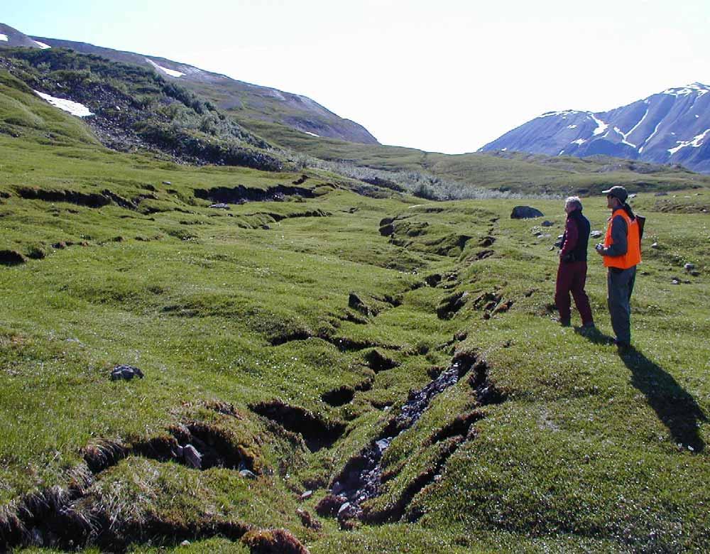
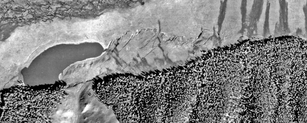
7 Short-lived glacial offsets Susitna glacier thrust, Nov Canwell glacier, Nov Chistochina glacier, July 2003 Chistochina glacier, July 2003

8 Km m
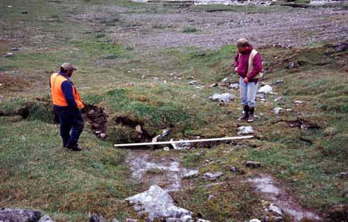
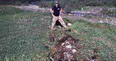
 1.")
9 Km (1.5) 1.4

10 Slate Creek Km 140
11 5m
12 5m
13

14 5.3 m Penultimate m
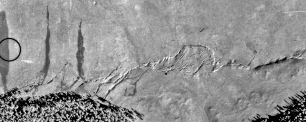
 100 150 200 250 300 Richardson Slate Creek Slana River Mentasta Tok Little Tok Nabesna Blue Highway Gillett Pass Cutoff River River Lake ne Canwell/Gakona Divide Highway")
15 Canwell - Gakona Glaciers Chistochina Glacier Denali -Totschunda Fault Transfer Zone July 2004 measurements July 2003 measurements November 2002 measurements Culled measurements penultimate Distance from epicenter (km) Richardson Slate Creek Slana River Mentasta Tok Little Tok Nabesna Blue Highway Gillett Pass Cutoff River River Lake ne Canwell/Gakona Divide Highway offset (8.1) Km 18

16 Km 184 Gillett Pas
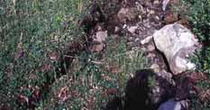
17 8.1 m


18 November 2002 Bone Creek 5.5m 5.5 meter lateral offset at Bone Creek Km 197 July 2003


19 Tok Cutoff Highway Km m

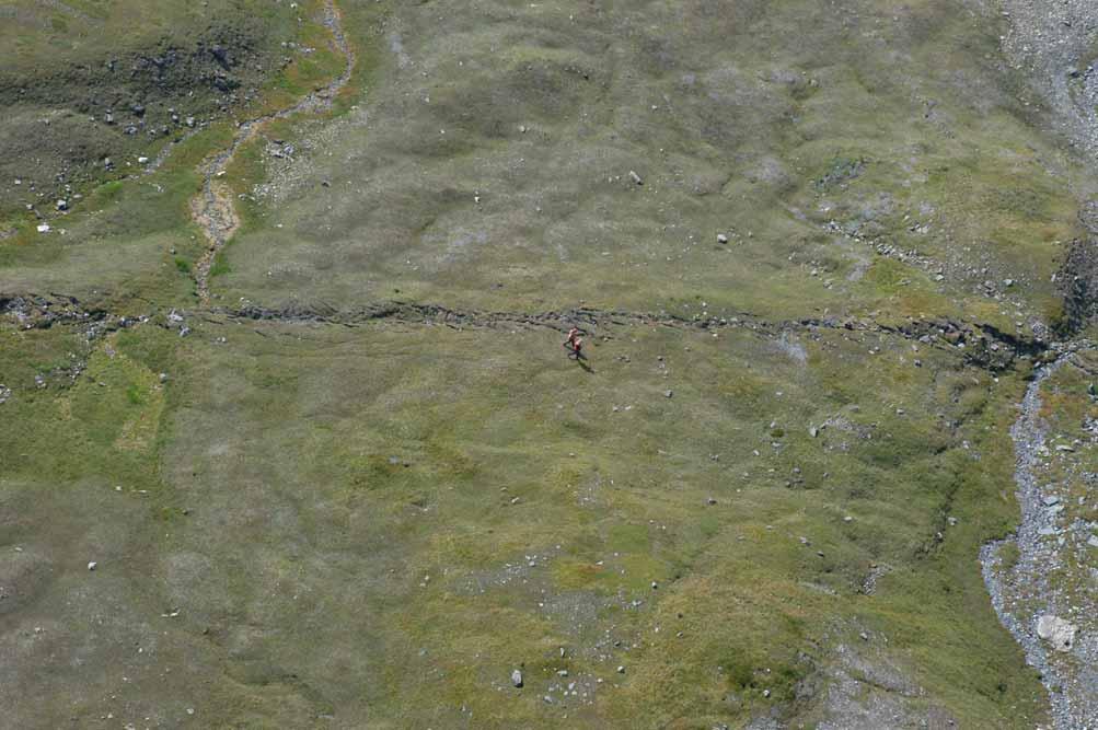
20 m m Primary control of 2002 rupture path is timing of past earthquakes/ accumulated strain on the Totschunda

21 Totschunda fault 250 km east of 02 epicenter


22 Horizontal slip (m) 10 West Fork Susitna - Black Canwell - Chistochina Denali -Totschunda Glacier Rapids Glacier Gakona Glacier Fault Transfer Zone Glaciers 8 July 2004 measurements July 2003 measurements 6 November 2002 measurements Culled measurements 4 2 Distance from epicenter (km) Augustana Epicenter Susitna/Black Creek Richardson Slate Creek Slana River Mentasta Tok Little Tok Nabesna Blue Rapids Divide Delta River Highway Gillett Pass Cutoff River River Lake Pipeline Canwell/Gakona Divide Highway (3.0) Km 250
23

24 8.2m Western Denali paleo-offsets 50 km west of 02 epicenter 8m in 2 events 4m

25 Eastern, unruptured (02), Denali Bean Lake, Tetlin River 20 km east of Totschunda fault intersection
26 Denali Rupture Characteristics Rupture of multiple faults:connectivity Slip distribution asymmetric: Dmax 180 km east of epicenter Slip divided into distinct sections (4-9) of Davg Large changes in slip occur over short ( 400 m) distances Within distinct sections point-specific D can vary by 90% Rupture structurally simple except at bends and steps Width of fault zone typically narrow (1-5m); no correlation between width of zone and Dnet Paleo offsets similar in size to 2002
27 The July 23, 1905 Bulnay Fault, Mongolia Surface Rupture D.P. Schwartz, S. Hecker, D. Ponti, W.E. Lund, H.D. Stenner, A. Bayasgalan


28 July 9 July Schlupp and Cisternas (2007)
29 Bulnay fault

30
31 Fissure with horizontal displacement Rupture Photos by A.Voznesenskii, 1905 Overthrust


32 complex trace large% of rupture


33
34 100 m

35 Buust Nuur 8.8 ± 2.3 m


 11 ± 2")
36 18 ± penultimate west of Buust Nuur 8 ± 0.6 (1905) 11 ± 2 (1905) 8.8 ± 1.0 (1905)

37 west of Oygon Nuur 8.75 ± 0.25


38 Zuun Hangay West 1905:8 ± 0.9 m m penultima yb05
39 Bulnay slip distribution e s?? Bilateral Slight asymmetry Dmax (11 m) near eastern end Davg (8 m) at surface Characteristic slip
40 Bulnay Rupture Characteristics Rupture of multiple faults: connectivity Slip distribution asymmetric: Dmax 170 km east of epicenter Similar amount of slip over long distances ( 200 km) Rupture commonly complex; multiple traces km apart Complexity may reflect long recurrence (~ 3ka) Paleo offsets similar in size to 1905
Description of faults
 GLG310 Structural Geology Description of faults Horizontal stretch Crustal thickness Regional elevation Regional character Issues Normal Thrust/reverse Strike-slip >1 1 in one direction and < 1 in
Yesterday scaling laws. An important one for seismic hazard analysis
 Yesterday scaling laws An important one for seismic hazard analysis Estimating the expected size of an earthquake expected on a fault for which the mapped length is known. Wells & Coppersmith, 1994 And
Earth and Planetary Science Letters
 Earth and Planetary Science Letters 270 (2008) 209 220 Contents lists available at ScienceDirect Earth and Planetary Science Letters journal homepage: www.elsevier.com/locate/epsl Detecting co-seismic
50 or 500? Current Issues in Estimating Fault Rupture Length. David P. Schwartz USGS Menlo Park
 50 or 500? Current Issues in Estimating Fault Rupture Length David P. Schwartz USGS Menlo Park Kondo et al (in press) Rockwell and Okumura (2010) 6.2 5 Hire Tom Rockwell! 4.9 5.1 5.2 4.5 5 4.7 6.1 North
STRUCTURE AND HOLOCENE SLIP OF THE JID FAULT, MONGOLIA ALTAI
 STRUCTURE AND HOLOCENE SLIP OF THE JID FAULT, MONGOLIA ALTAI LAURA K.O. SMITH AND SARAHTSETSEG PUREDORG Princeton University, Mongolian University of Science and Technology Sponsors: Ramon Gonzalez-Mieres
Description of faults
 GLG310 Structural Geology Description of faults Horizontal stretch Crustal thickness Regional elevation Regional character Issues Normal Thrust/reverse Strike-slip >1 1 in one direction and < 1 in
Why the 2002 Denali fault rupture propagated onto the Totschunda fault: Implications for fault branching and seismic hazards
 JOURNAL OF GEOPHYSICAL RESEARCH, VOL. 117,, doi:10.1029/2011jb008918, 2012 Why the 2002 Denali fault rupture propagated onto the Totschunda fault: Implications for fault branching and seismic hazards David
4. Geotechnical and Geological Aspects. 4.1 Geotechnical Aspects
 4. Geotechnical and Geological Aspects 4.1 Geotechnical Aspects A preliminary reconnaissance of the geotechnical conditions of Duzce, Kaynasli, and Bolu urban areas was done during the Turkey Expedition
SCEC Earthquake Gates Workshop Central Death Valley Focus Area
 SCEC Earthquake Gates Workshop Central Death Valley Focus Area Fault Gates: Rheology, fault geometry, stress history or directionality? How do we recognize or suspect a fault gate? Paleoseismic or historic
depression above scarp scarp
 1 LAB 1: FIELD TRIP TO McKINLEYVILLE AND MOUTH OF THE MAD RIVER OBJECTIVES: a. to look at geomorphic and geologic evidence for large scale thrust-faulting of young sediments in the Humboldt Bay region
Earthquakes and Faulting
 Earthquakes and Faulting Crustal Strength Profile Quakes happen in the strong, brittle layers Great San Francisco Earthquake April 18, 1906, 5:12 AM Quake lasted about 60 seconds San Francisco was devastated
Chapter 2. Earthquake and Damage
 EDM Report on the Chi-Chi, Taiwan Earthquake of September 21, 1999 2.1 Earthquake Fault 2.1.1 Tectonic Background The island of Taiwan is located in the complex junction where the Eurasian and Philippine
GROUND SURFACE VISUALIZATION USING RED RELIEF IMAGE MAP FOR A VARIETY OF MAP SCALES
 GROUND SURFACE VISUALIZATION USING RED RELIEF IMAGE MAP FOR A VARIETY OF MAP SCALES T. Chiba a, B. Hasi a * a Asia Air Survey Co., Ltd., Kawasaki, Japan (has.baator, ta.chiba,)@ajiko.co.jp Commission II,
Elastic rebound theory
 Elastic rebound theory Focus epicenter - wave propagation Dip-Slip Fault - Normal Normal Fault vertical motion due to tensional stress Hanging wall moves down, relative to the footwall Opal Mountain, Mojave
Earthquakes and Earthquake Hazards Earth - Chapter 11 Stan Hatfield Southwestern Illinois College
 Earthquakes and Earthquake Hazards Earth - Chapter 11 Stan Hatfield Southwestern Illinois College What Is an Earthquake? An earthquake is the vibration of Earth, produced by the rapid release of energy.
GPS Strain & Earthquakes Unit 5: 2014 South Napa earthquake GPS strain analysis student exercise
 GPS Strain & Earthquakes Unit 5: 2014 South Napa earthquake GPS strain analysis student exercise Strain Analysis Introduction Name: The earthquake cycle can be viewed as a process of slow strain accumulation
STUDY COMPLETION REPORT SITE-SPECIFIC SEISMIC HAZARD STUDY (16.6) ATTACHMENT 8: SEISMIC NETWORK 2013 ANNUAL SEISMICITY REPORT
 ATTACHMENT 8: SEISMIC NETWORK 2013 ANNUAL SEISMICITY REPORT") STUDY COMPLETION REPORT SITE-SPECIFIC SEISMIC HAZARD STUDY (16.6) ATTACHMENT 8: SEISMIC NETWORK 2013 ANNUAL SEISMICITY REPORT Susitna-Watana Hydroelectric Project Alaska Energy Authority FERC Project No.
STUDY COMPLETION REPORT SITE-SPECIFIC SEISMIC HAZARD STUDY (16.6) ATTACHMENT 8: SEISMIC NETWORK 2013 ANNUAL SEISMICITY REPORT Susitna-Watana Hydroelectric Project Alaska Energy Authority FERC Project No.
S. Toda, S. Okada, D. Ishimura, and Y. Niwa International Research Institute of Disaster Science, Tohoku University, Japan
 The first surface-rupturing earthquake in 20 years on a HERP major active fault: Mw=6.2 2014 Nagano, Japan, event along the Itoigawa-Shizuoka Tectonic Line is not characteristic S. Toda, S. Okada, D. Ishimura,
Crustal Deformation. Earth Systems 3209
 Crustal Deformation Earth Systems 3209 Crustal Deformation pg. 415 Refers to all changes in the original form and/or size of a rock body. May also produce changes in the location and orientation of rocks.
Introduction Faults blind attitude strike dip
 Chapter 5 Faults by G.H. Girty, Department of Geological Sciences, San Diego State University Page 1 Introduction Faults are surfaces across which Earth material has lost cohesion and across which there
Earthquake. What is it? Can we predict it?
 Earthquake What is it? Can we predict it? What is an earthquake? Earthquake is the vibration (shaking) and/or displacement of the ground produced by the sudden release of energy. Rocks under stress accumulate
Earthquakes and Seismotectonics Chapter 5
 Earthquakes and Seismotectonics Chapter 5 What Creates Earthquakes? The term Earthquake is ambiguous: Applies to general shaking of the ground and to the source of the shaking We will talk about both,
Surface Process Hazards Unit 2: Landscape Feature Scavenger Hunt
 Surface Process Hazards Unit 2: Landscape Feature Scavenger Hunt Sarah Hall (College of the Atlantic) and Becca Walker (Mt. San Antonio College) The following pages each have a series of questions about
Section Forces Within Earth. 8 th Grade Earth & Space Science - Class Notes
 Section 19.1 - Forces Within Earth 8 th Grade Earth & Space Science - Class Notes Stress and Strain Stress - is the total force acting on crustal rocks per unit of area (cause) Strain deformation of materials
San Andreas Movie Can It Happen?
 San Andreas Movie Can It Happen? Learning Objectives (LO) Lecture 14: Faults and Quakes Read: Chapter 10 and 11 Homework #12 due Thursday 12pm What we ll learn today:! 1. Compare strike-slip to dip-slip
ESTIMATES OF HORIZONTAL DISPLACEMENTS ASSOCIATED WITH THE 1999 TAIWAN EARTHQUAKE
 ESTIMATES OF HORIZONTAL DISPLACEMENTS ASSOCIATED WITH THE 1999 TAIWAN EARTHQUAKE C. C. Chang Department of Surveying and Mapping Engineering Chung Cheng Institute of Technology, Taiwan, ROC ABSTRACT A
RELOCATION OF THE MACHAZE AND LACERDA EARTHQUAKES IN MOZAMBIQUE AND THE RUPTURE PROCESS OF THE 2006 Mw7.0 MACHAZE EARTHQUAKE
 RELOCATION OF THE MACHAZE AND LACERDA EARTHQUAKES IN MOZAMBIQUE AND THE RUPTURE PROCESS OF THE 2006 Mw7.0 MACHAZE EARTHQUAKE Paulino C. FEITIO* Supervisors: Nobuo HURUKAWA** MEE07165 Toshiaki YOKOI** ABSTRACT
Kinematics of the Southern California Fault System Constrained by GPS Measurements
 Title Page Kinematics of the Southern California Fault System Constrained by GPS Measurements Brendan Meade and Bradford Hager Three basic questions Large historical earthquakes One basic question How
Jocelyn Karen Campbell
 THE UNCERTAINTIES IN ASSESSING THE IMPACT OF REGIONAL SEISMICITY AT THE WIL SITE Statement of Evidence by Jocelyn Karen Campbell A CANTERBURY FAULTS coded by type CHARACTERISTICS OF THRUST FAULTS IN CANTERBURY
Lecture # 6. Geological Structures
 1 Lecture # 6 Geological Structures ( Folds, Faults and Joints) Instructor: Dr. Attaullah Shah Department of Civil Engineering Swedish College of Engineering and Technology-Wah Cantt. 2 The wavy undulations
UNDERSTANDING GEOLOGIC M APS
 Name: Lab Section: work in groups, but each person turns in his/her own GEOSCIENCE 001 L AB UNDERSTANDING GEOLOGIC M APS Geologic maps are colorful and even beautiful, but they also contain an amazing
(First Edition: prepared on 29/12/2003)
") (First Edition: prepared on 29/12/2003) Dr Sassan Eshghi 1 and Dr Mehdi Zaré 2 International Institute of Earthquake Engineering and Seismology, Tehran, P.O.Box: 19395/3913, IRAN e-mails: 1)s.eshghi@iiees.ac.ir,
(First Edition: prepared on 29/12/2003) Dr Sassan Eshghi 1 and Dr Mehdi Zaré 2 International Institute of Earthquake Engineering and Seismology, Tehran, P.O.Box: 19395/3913, IRAN e-mails: 1)s.eshghi@iiees.ac.ir,
Science Starter. Describe in your own words what an Earthquake is and what causes it. Answer The MSL
 Science Starter Describe in your own words what an Earthquake is and what causes it. Answer The MSL WHAT IS AN EARTHQUAKE AND HOW DO WE MEASURE THEM? Chapter 8, Section 8.1 & 8.2 Looking Back Deserts Wind-shaped
Earthquakes. Forces Within Eartth. Faults form when the forces acting on rock exceed the rock s strength.
 Earthquakes Vocabulary: Stress Strain Elastic Deformation Plastic Deformation Fault Seismic Wave Primary Wave Secondary Wave Focus Epicenter Define stress and strain as they apply to rocks. Distinguish
Today: Basic regional framework. Western U.S. setting Eastern California Shear Zone (ECSZ) 1992 Landers EQ 1999 Hector Mine EQ Fault structure
 1992 Landers EQ 1999 Hector Mine EQ Fault structure") Today: Basic regional framework Western U.S. setting Eastern California Shear Zone (ECSZ) 1992 Landers EQ 1999 Hector Mine EQ Fault structure 1 2 Mojave and Southern Basin and Range - distribution of strike-slip
Today: Basic regional framework Western U.S. setting Eastern California Shear Zone (ECSZ) 1992 Landers EQ 1999 Hector Mine EQ Fault structure 1 2 Mojave and Southern Basin and Range - distribution of strike-slip
Strike & Dip. Structural Geology I: Folds & Faults 2009 Lect. 18, J. Steven Kite, West Virginia University
 2 Apr Structural Geology I: Folds & Faults 2009 Lect. 18, J. Steven Kite, West Virginia University Steeply dipping axial plane cleavage. These folded sedimentary layers exposed near Sullivan River in southeastern
Use a highlighter to mark the most important parts, or the parts. you want to remember in the background information.
 P a g e 1 Name A Fault Model Purpose: To explore the types of faults and how they affect the geosphere Background Information: A fault is an area of stress in the earth where broken rocks slide past each
Learning goals - January 16, Describe the geometry of a fault (1) orientation of the plane (strike and dip) (2) slip vector
 orientation of the plane (strike and dip) (2) slip vector") Learning goals - January 16, 2012 You will understand how to: Describe the geometry of a fault (1) orientation of the plane (strike and dip) (2) slip vector Understand concept of slip rate and how it is
Learning goals - January 16, 2012 You will understand how to: Describe the geometry of a fault (1) orientation of the plane (strike and dip) (2) slip vector Understand concept of slip rate and how it is
Deformation of Rocks. Orientation of Deformed Rocks
 Deformation of Rocks Folds and faults are geologic structures caused by deformation. Structural geology is the study of the deformation of rocks and its effects. Fig. 7.1 Orientation of Deformed Rocks
General Geologic Setting and Seismicity of the FHWA Project Site in the New Madrid Seismic Zone
 General Geologic Setting and Seismicity of the FHWA Project Site in the New Madrid Seismic Zone David Hoffman University of Missouri Rolla Natural Hazards Mitigation Institute Civil, Architectural & Environmental
Geo736: Seismicity and California s Active Faults Introduction
 Geo736: Seismicity and California s Active Faults Course Notes: S. G. Wesnousky Spring 2018 Introduction California sits on the boundary of the Pacific - North American plate boundary (Figure 1). Relative
Earthquakes. Building Earth s Surface, Part 2. Science 330 Summer What is an earthquake?
 Earthquakes Building Earth s Surface, Part 2 Science 330 Summer 2005 What is an earthquake? An earthquake is the vibration of Earth produced by the rapid release of energy Energy released radiates in all
CRUSTAL DEFORMATION. Chapter 10
 CRUSTAL DEFORMATION and dgeologic Structures t Chapter 10 Deformation Df Deformation involves: Stress the amount of force applied to a given area. Types of Stress: Confining Stress stress applied equally
In this lab, we will study and analyze geologic maps from a few regions, including the Grand Canyon, western Wyoming, and coastal California.
 Name: Lab Section: work in groups, but each person turns in his/her own GEOSCIENCE 001 LAB UNDERSTANDING GEOLOGIC MAPS Geologic maps are colorful and even beautiful, but they also contain an amazing amount
Earthquakes Chapter 19
 Earthquakes Chapter 19 Does not contain complete lecture notes. What is an earthquake An earthquake is the vibration of Earth produced by the rapid release of energy Energy released radiates in all directions
Chapter 15 Structures
 Chapter 15 Structures Plummer/McGeary/Carlson (c) The McGraw-Hill Companies, Inc. TECTONIC FORCES AT WORK Stress & Strain Stress Strain Compressive stress Shortening strain Tensional stress stretching
Lecture Outline Wednesday-Monday April 18 23, 2018
 Lecture Outline Wednesday-Monday April 18 23, 2018 Questions? Lecture Final Exam Lecture Section 1 Friday May 4, 8:00-10:00am Lecture Section 2 Friday May 4, 3:10-5:10 pm Final Exam is 70% new material
Neotectonic Implications between Kaotai and Peinanshan
 Neotectonic Implications between Kaotai and Peinanshan Abstract Longitudinal Valley was the suture zone between the Philippine Sea plate and the Eurasia plate. Peinanshan was the southest segment of the
Lab 9: Satellite Geodesy (35 points)
") Lab 9: Satellite Geodesy (35 points) Here you will work with GPS Time Series data to explore plate motion and deformation in California. This lab modifies an exercise found here: http://www.unavco.org:8080/cws/pbonucleus/draftresources/sanandreas/
Lab 9: Satellite Geodesy (35 points) Here you will work with GPS Time Series data to explore plate motion and deformation in California. This lab modifies an exercise found here: http://www.unavco.org:8080/cws/pbonucleus/draftresources/sanandreas/
This document is downloaded from DR-NTU, Nanyang Technological University Library, Singapore.
 This document is downloaded from DR-NTU, Nanyang Technological University Library, Singapore. Title Author(s) Citation Kinematic behavior of southern Alaska constrained by westward decreasing postglacial
UNIT 10 MOUNTAIN BUILDING AND EVOLUTION OF CONTINENTS
 UNIT 10 MOUNTAIN BUILDING AND EVOLUTION OF CONTINENTS ROCK DEFORMATION Tectonic forces exert different types of stress on rocks in different geologic environments. STRESS The first, called confining stress
Man-made Earthquakes. 2 June 16. Horst Rademacher HH Lect 4: Earthquakes in the US. Summer Session 2016
 2 June 16 Summer Session 2016 Horst Rademacher HH Lect 4: Earthquakes in the US Man-made Earthquakes http://seismo.berkeley.edu/~horst/summer2016.html Recap from last lecture I: Faults, Earthquakes and
For Goodness Sake, Let me Examine the Evidence, Ayhan!!!
 For Goodness Sake, Let me Examine the Evidence, Ayhan!!! Deformation Belts and Fracture Belts along Earthquake Ruptures: INTRODUCTION The Ayhan and Arvid Comedy Hour and a Half!!! 13 February 2006 Kaynaşlı,
BRIEFING MEMO ON RESERVOIR TRIGGERED SEISMICITY (RTS)
") BRIEFING MEMO ON RESERVOIR TRIGGERED SEISMICITY (RTS) 1. General. The issue of reservoir-triggered seismicity (RTS) has been controversial, and hotly debated, for many decades. There has been general recognition
BRIEFING MEMO ON RESERVOIR TRIGGERED SEISMICITY (RTS) 1. General. The issue of reservoir-triggered seismicity (RTS) has been controversial, and hotly debated, for many decades. There has been general recognition
Answers: Internal Processes and Structures (Isostasy)
") Answers: Internal Processes and Structures (Isostasy) 1. Analyse the adjustment of the crust to changes in loads associated with volcanism, mountain building, erosion, and glaciation by using the concept
Answers: Internal Processes and Structures (Isostasy) 1. Analyse the adjustment of the crust to changes in loads associated with volcanism, mountain building, erosion, and glaciation by using the concept
Geologic Structures. Changes in the shape and/or orientation of rocks in response to applied stress
 Geologic Structures Changes in the shape and/or orientation of rocks in response to applied stress Figure 15.19 Can be as big as a breadbox Or much bigger than a breadbox Three basic types Fractures >>>
Chapt pt 15 er EARTHQUAKES! BFRB P 215 ages -226
 Chapter 15 EARTHQUAKES! BFRB Pages 215-226226 Earthquake causes An earthquake is the shaking of the Earth s crust caused by a release of energy The movement of the Earth s plates causes most earthquakes
WAACY Magnitude PSF Model (Wooddell, Abrahamson, Acevedo-Cabrera, and Youngs) Norm Abrahamson DCPP SSC workshop #3 Mar 25, 2014
 Norm Abrahamson DCPP SSC workshop #3 Mar 25, 2014") WAACY Magnitude PSF Model (Wooddell, Abrahamson, Acevedo-Cabrera, and Youngs) Norm Abrahamson DCPP SSC workshop #3 Mar 25, 2014 UCERF3 Allowing larger magnitudes by linking rupture segments Grand inversion
WAACY Magnitude PSF Model (Wooddell, Abrahamson, Acevedo-Cabrera, and Youngs) Norm Abrahamson DCPP SSC workshop #3 Mar 25, 2014 UCERF3 Allowing larger magnitudes by linking rupture segments Grand inversion
Mechanics of Earthquakes and Faulting
 Mechanics of Earthquakes and Faulting Lecture 20, 30 Nov. 2017 www.geosc.psu.edu/courses/geosc508 Seismic Spectra & Earthquake Scaling laws. Seismic Spectra & Earthquake Scaling laws. Aki, Scaling law
Elastic Rebound Theory
 Earthquakes Elastic Rebound Theory Earthquakes occur when strain exceeds the strength of the rock and the rock fractures. The arrival of earthquakes waves is recorded by a seismograph. The amplitude of
The Omega fault is an Atirro fault splay that branches westward off of the main trace at
 This supplemental information file for Neotectonic faulting and forearc sliver motion along the Atirro-Río Sucio fault system, Costa Rica, Central America by Montero et al. contains descriptions of secondary
Deformation of the Crust
 Deformation of the Crust Review Choose the best response. Write the letter of that choice in the space provided. 1. The state of balance between the thickness of the crust and the depth at which it rides
Response Analysis of a Buried Pipeline Considering the
 Response Analysis of a Buried Pipeline Considering the process Process of fault Fault movement Movement A.W. Liu, X.H. Jia Institute of Geophysics, CEA, China SUMMARY: For the seismic design of a pipeline
What Causes Rock to Deform?
 Crustal Deformation Earth, Chapter 10 Chapter 10 Crustal Deformation What Causes Rock to Deform? Deformation is a general term that refers to all changes in the shape or position of a rock body in response
CHAPTER 1 BASIC SEISMOLOGY AND EARTHQUAKE TERMINOLGY. Earth Formation Plate Tectonics Sources of Earthquakes...
 CHAPTER 1 BASIC SEISMOLOGY AND EARTHQUAKE TERMINOLGY Earth Formation... 1-2 Plate Tectonics... 1-2 Sources of Earthquakes... 1-3 Earth Faults... 1-4 Fault Creep... 1-5 California Faults... 1-6 Earthquake
to: Interseismic strain accumulation and the earthquake potential on the southern San
 Supplementary material to: Interseismic strain accumulation and the earthquake potential on the southern San Andreas fault system by Yuri Fialko Methods The San Bernardino-Coachella Valley segment of the
Geometry of co-seismic surface ruptures and tectonic meaning of the 23 October 2011 Mw 7.1 Van earthquake (East Anatolian Region, Turkey)
") Geometry of co-seismic surface ruptures and tectonic meaning of the 23 October 2011 Mw 7.1 Van earthquake (East Anatolian Region, Turkey) Bülent Dogan & Ahmet Karakaș. Journal of Structural Geology, 46(2013),
Geometry of co-seismic surface ruptures and tectonic meaning of the 23 October 2011 Mw 7.1 Van earthquake (East Anatolian Region, Turkey) Bülent Dogan & Ahmet Karakaș. Journal of Structural Geology, 46(2013),
Earthquakes and How to Measure Them
 Earthquakes and How to Measure Them Earth Systems Georgia Performance Standards: SES2c. Relate certain geologic hazards to plate tectonic settings. Created by: Christy Dion Paulding County High School
LECTURES 10 and 11 - Seismic Sources Hrvoje Tkalčić
 LECTURES 10 and 11 - Seismic Sources Hrvoje Tkalčić *** N.B. The material presented in these lectures is from the principal textbooks, other books on similar subject, the research and lectures of my colleagues
The Seismic Hazardscape of New Zealand
 The Seismic Hazardscape of New Zealand Mark Stirling Professor of Earthquake Science Introduction Plate tectonic setting of New Zealand Seismic hazards for University of Otago campuses Kaikoura earthquake
Once you have opened the website with the link provided choose a force: Earthquakes
 Name: Once you have opened the website with the link provided choose a force: Earthquakes When do earthquakes happen? On the upper left menu, choose number 1. Read What is an Earthquake? Earthquakes happen
Magnitude 7.0 PAPUA, INDONESIA
 A 7.0 magnitude earthquake struck eastern Indonesia's mountainous West Papua province on Saturday but there were no immediate reports of casualties or damage. The region is sparsely populated. According
The Devils Postpile and its Unusual Surroundings. Shannon B. Carpenter A May 3, 2001
 The Devils Postpile and its Unusual Surroundings Shannon B. Carpenter A25584605 May 3, 2001 Abstract: The Devils Postpile is located in the eastern Sierra Nevada region just a few miles southwest of the
Distortion Effects of Faults on Gravity Worm Strings Robin O Leary
 Distortion Effects of Faults on Gravity Worm Strings Robin O Leary Problem Can upward continued gravity anomaly worm strings be used as a tool to determine the dip direction of an offsetting structure
GEOL104: Exploring the Planets LAB 5: PLANETARY TECTONICS
 GEOL104: Exploring the Planets LAB 5: PLANETARY TECTONICS OBJECTIVES: I. Understand the three basic types of tectonic interactions that can occur II. Identify tectonic interactions on other planets MATERIALS:
Earthquakes Earth, 9th edition, Chapter 11 Key Concepts What is an earthquake? Earthquake focus and epicenter What is an earthquake?
 1 2 3 4 5 6 7 8 9 10 Earthquakes Earth, 9 th edition, Chapter 11 Key Concepts Earthquake basics. "" and locating earthquakes.. Destruction resulting from earthquakes. Predicting earthquakes. Earthquakes
Surface Faulting and Deformation Assessment & Mitigation
 Surface Faulting and Deformation Assessment & Mitigation Summary of a Shlemon Specialty Conference sponsored by the Association of Environmental & Engineering Geologists convened on February 19 & 20, 2009
Zone of largest coseismic slips Rupture length (km) Rupture length (km)
 Rupture length (km)") Supplementary Figure S; Perrin et al. Relations between earthquake surface traces and slips, and architecture and, for all earthquakes analyzed in present study. 97 Bogd earthquake (Mw.) Gichgeniyn uruu
Supplementary Figure S; Perrin et al. Relations between earthquake surface traces and slips, and architecture and, for all earthquakes analyzed in present study. 97 Bogd earthquake (Mw.) Gichgeniyn uruu
Journal of Geophysical Research Letters Supporting Information for
 Journal of Geophysical Research Letters Supporting Information for InSAR observations of strain accumulation and fault creep along the Chaman Fault system, Pakistan and Afghanistan H. Fattahi 1, F. Amelung
Topographic Maps and Profiles
 Name: Date: Period: Earth Science Foundations The Physical Setting: Earth Science CLASS NOTES! Topographic Maps [contour maps] -! Topographic maps show three-dimensional shapes in two dimensions Elevation
SEISMIC-HAZARD ASSESSMENT: Conditional Probability
 Conditional Probability SEISMIC-HAZARD ASSESSMENT: Conditional Probability Supplies Needed calculator PURPOSE Previous exercises in this book have outlined methods for inferring the patterns and history
Magnitude 7.0 N of ANCHORAGE, ALASKA
 A magnitude 7.0 earthquake occurred just before 8:30 am local time 8 miles north of Anchorage at a depth of 40.9 km (25.4 miles). There are reports of major infrastructure damage and damage to many homes
6.1 Geological Stresses
 www.ck12.org Chapter 6. Geological Activity from Plate Tectonics Processes 6.1 Geological Stresses Define the types of geological stress and describe their affect on various types of rock under a range
Seismic Source Mechanism
 Seismic Source Mechanism Yuji Yagi (University of Tsukuba) Earthquake Earthquake is a term used to describe both failure process along a fault zone, and the resulting ground shaking and radiated seismic
Team Name. Name(s) SSSS Unome Geologic Mapping Test Packet p1
 SSSS Unome Geologic Mapping Test Packet p1") Scioly Summer Study Session 2018-2019 Geologic Mapping Test Packet Written by Unome Instructions 1) This test is based on the 2016 rules for Geologic Mapping. 2) This test is out of 115 points. Questions
Scioly Summer Study Session 2018-2019 Geologic Mapping Test Packet Written by Unome Instructions 1) This test is based on the 2016 rules for Geologic Mapping. 2) This test is out of 115 points. Questions
A Teleseismic Study of the 2002 Denali Fault, Alaska, Earthquake and Implications for Rapid Strong-Motion Estimation
 A Teleseismic Study of the 2002 Denali Fault, Alaska, Earthquake and Implications for Rapid Strong-Motion Estimation Chen Ji, a) Don V. Helmberger, a) and David J. Wald, b) M.EERI Slip histories for the
WESTERN STATES SEISMIC POLICY COUNCIL POLICY RECOMMENDATION Definitions of Recency of Surface Faulting for the Basin and Range Province
 WESTERN STATES SEISMIC POLICY COUNCIL POLICY RECOMMENDATION 15-3 Definitions of Recency of Surface Faulting for the Basin and Range Province Policy Recommendation 15-3 WSSPC recommends that each state
Lecture 6 Folds, Faults and Deformation Dr. Shwan Omar
 Fold: A fold is a bend or wrinkle of rock layers or foliation; folds form as a sequence of ductile deformation. Folding is the processes by which crustal forces deform an area of crust so that layers of
From Earthquakes to Mountains: the Earth s Crust in Motion
 Dean s Freshman Honor Seminar (SCI 110) Eric Calais Associate Professor of Geophysics Purdue University Department of Earth and Atmospheric Sciences ecalais@purdue.edu http:/www.eas.purdue.edu/~calais
Reconnaissance. Of the. Denis mineral claims. Situated at Kilometer 844 of the Alaska Highway. Liard Mining Division. Northeastern British Columbia
 Reconnaissance Of the Denis mineral claims Situated at Kilometer 844 of the Alaska Highway Liard Mining Division Northeastern British Columbia N.T.S. 94M.075 Latitude 59 42 25 Longitude 127 13 12 Field
Structural Geology and Geology Maps Lab
 Structural Geology and Geology Maps Lab Mesa College Geology 101 Lab Ray Rector: Instructor Structural Geology Lab Pre-Lab Resources Pre-Lab Internet Links 1) Fundamentals of Structural Geology 2) Visualizing
Earthquakes.
 Earthquakes http://quake.usgs.gov/recenteqs/latestfault.htm An earthquake is a sudden motion or shaking of the Earth's crust, caused by the abrupt release of stored energy in the rocks beneath the surface.
Contemporary Tectonics and Seismicity of the Teton and Southern Yellowstone Fault Systems- Phase I
 University of Wyoming National Park Service Research Center Annual Report Volume 4 4th Annual Report, 1980 Article 16 1-1-1980 Contemporary Tectonics and Seismicity of the Teton and Southern Yellowstone
COSMORPHOLOGY - May 2009
 Name COSMORPHOLOGY - May 2009 Geologic landforms Purpose: By studying aerial photographs you will learn to identify different kinds of geologic features based on their different morphologies and learn
ALASKA GEOLOGICAL SOCIETY PUBLICATIONS Stratigraphic And Structure Sections
 ALASKA GEOLOGICAL SOCIETY PUBLICATIONS 2007-2008 Stratigraphic And Structure Sections Price Western Alaska Bristol Bay Region Stratigraphic Correlation Sections (CD)... $12.00 AGS Member Price... $10.00
Plate Tectonics. Structure of the Earth
 Plate Tectonics Structure of the Earth The Earth can be considered as being made up of a series of concentric spheres, each made up of materials that differ in terms of composition and mechanical properties.
Section 19.1: Forces Within Earth Section 19.2: Seismic Waves and Earth s Interior Section 19.3: Measuring and Locating.
 CH Earthquakes Section 19.1: Forces Within Earth Section 19.2: Seismic Waves and Earth s Interior Section 19.3: Measuring and Locating Earthquakes Section 19.4: Earthquakes and Society Section 19.1 Forces
What Is an Earthquake? What Is an Earthquake? Earthquake
 Earthquakes Earth,, Chapter 11 Built Earthquakes: on shaky summary ground, in haiku form Memphis, south of New Madrid - whole lotta shakin'... What Is an Earthquake? An earthquake is ground shaking caused
Earthquakes and How to Measure Them
 Earthquakes and How to Measure Them Earth Systems Georgia Performance Standards: SES2c. Relate certain geologic hazards to plate tectonic settings. Created by: Christy Dion Paulding County High School
WRANGELL YAKUTAT PACIFIC PLATE BLOCK
 Tectonics, mountain building, subduction, and volcanism in south-central Alaska Peter Haeussler 1, Jeff Freymueller 2, Seth Moran 3, John Power 3, Rick Saltus 4 1 U.S. Geological Survey, 4200 University