BHUTAN. Reducing Disaster Risks for a safe and Happy. Samdrup Dorji, Survey Engineer Cadastral Information Division National Land Commission, BHUTAN
|
|
|
- Belinda Whitehead
- 5 years ago
- Views:
Transcription


1 NATIONAL LAND COMMISSION BHUTAN Reducing Disaster Risks for a safe and Happy Bhutan Samdrup Dorji, Survey Engineer Cadastral Information Division National Land Commission, BHUTAN
2 Presentation Outline Introduction Hazards in Bhutan Adaptation Measures Major functions of Disaster Management Department. Challenges Conclusions
3 Introduction Bhutan is a tiny Himalayan Kingdom with population of over 700,000 approximately. It covers about 340 km of the entire Himalaya. Geographic Location It is situated in the eastern Himalayas between latitudes 26º40 to 28º20 N and longitudes 88º45 to 92º7 E. Bordered by the Tibetan Plateau in the north and the Indian States of Sikkim in the west, West Bengal, and Assam in the south, and Arunachal Pradesh in the east Physical Features Total land area = 38,394 sq. km. The rugged mountainous terrain has elevation ranging from 150 m to 8000 m above sea level % of the totalt land is 4000 meters above MSL and mostly covered by snow and ice throughout the year. 3.3 % of the total land is covered by the glaciers.
4 Tibetan Plateau
5 Economy Hydropower is the main economy in Bhutan The hydropower projects are Chukha, Kurichu, Basachu, Tala Hydroelectricity, Punatsangchu I and II, Mangdechu, Chamkharchu, Kholongchu, Kuri Gongri and Amochu While some of the projects are already generating power, the others are under construction stage. Bhutan has a vision to generate 10,000MW by Climate Climate in Bhutan is dominated by a southwestern monsoon, which originates from the Bay of Bengal Climatically Bhutan is divided into three broad zones: tropical in the southern foothills, cool winters and hot summers in central valleys, and severe winters and cool summers in northern mountains Southern foothills are hot and humid during the summer months and quite cool in winter Inner hills are cold in winter and warm in summer with a pleasant spring and autumn with mild temperatures
6 Nt NaturalResources Flora 72% of the entire country is covered by forest with various species of plants including medicinal plants. And as per the constitution, Bhutan is required to maintain the 60 % forest covereage at all times. Fauna Over 165 species of animals including golden langur, takin, blue sheep, snow leopard, red panda, Himalayan black bear, wild pig, musk deer and rare black necked cranes.
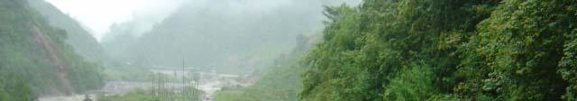
7 Hazards in Bhutan In Bhutan the area in the south is highly prone to Landslides and related natural hazards mainly due to weak geological formation and high rate of precipitation. The area in the north are subject to severe Glacial Lake Outburst Floods, especially due to climate change. The entire northern part of Bhutan is coveredbyiceandsnow,resultinginglaciersthatarethesourcesofthe rivers that traverse from north to the south. There are 667 glaciers and 2674 glacial lakes in Bhutan alone. Although these glaciers are perennial sources of water they are also potential flood disasters. In total, 25 glacial lakes have been identified as potentially dangerous.
8 The current Hazards of Bhutan GLOF Flash floods Landslides Earthquakes Forest fires Epidemic out breaks
9 Glacier Lake Outbursts Floods Number of Glaciers = 667 Number of Glacial Lakes = 2674 Potentially Dangerous Glacial Lakes = 25 Most rivers in Bhutan are Glacier fed Causes: Global Warming Avalanches (Rapidly sliding masses of snow) Earthquakes Past Events: 1957, 1960, 1994
10 Potentially Dangerous Glacial Lakes of Bhutan Pho Chu Sub Basin : 9 Mo Chu Sub Basin : 5 Chamkhar Chu Sub Basin: 3 Kuri Chu Sub Basin: 1 Mangde Chu Sub Basin: 7
11 Current Scenario of Glaciers and Glacial Lakes in Lunana Tsojo Glacier Bechung Glacier Rapstreng Tso Rapstreng Tso Thorthorm i Lugge Tso Thanza village
12 Present Situation of Glaciers and Glacial Lakes in East Lunana in 2008 Singer Gang (Table Mountain) R3R Bechung Glacier Rapstreng Tso Thorthormi Glacier


 human,")

13 Luggye Tso which burst in October 7, 1994 and down stream Punakha Dzong, partially damaged Impact of 1994 flood on one of the oldest temples in front of Punakha Dzong. Loss of lives (21 people killed ) human, cattle Damages to Properties Dzong, bridges, houses, rice fields
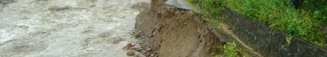
14 Flash Floods Recurrent in Bhutan Eastern and Southern districts most vulnerable. Past Events: 2000 Phuntsholing and Pasakha Floods 2004 Severe landslides in the east (9 Lives lost)
15 Loss and Damage 13 lives lost. Govt. Infrastructure: Nu. 544 Millions Farm and feeder roads: Nu. 47 millions Agriculture property: Nu. 7.5 million Bridges: Nu.56 millions Drinking water and irrigation: Nu. 45 million Livestock: Nu. 15 million Private properties: p Nu. 7 million Total: Nu. 722 million

16
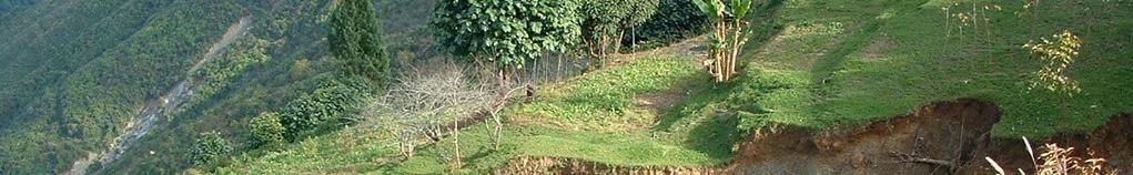
17 Landslides Eastern and southern Bhutan are very much prone to landslides while the area in the north is prone to glaciers and other natural hazards. Associated withvery heavy rainfall, tend to worsen the effects of flooding that often accompanies these events. In areas burnt by forest lesser amount of precipitation may initiate landslides. Other triggers: Earthquake, Poor land management.


18


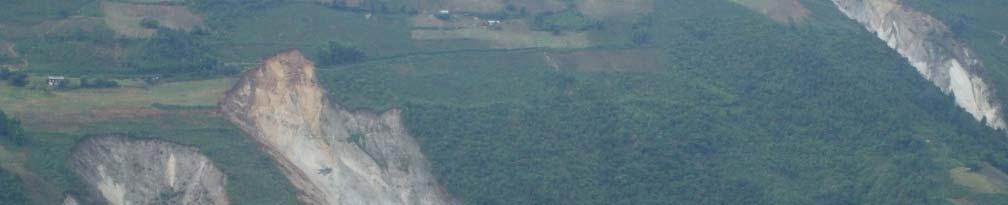

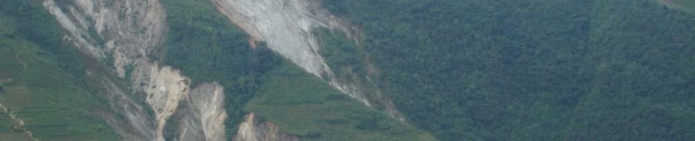
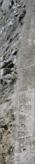
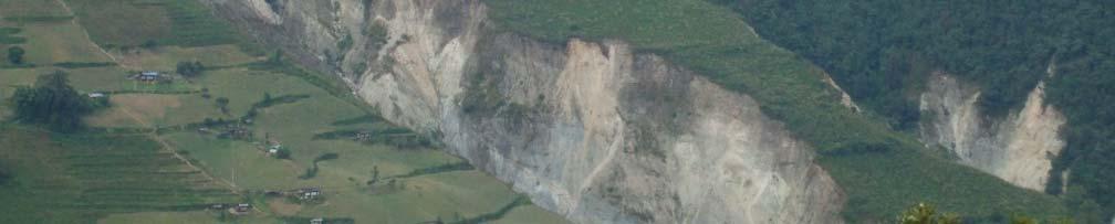
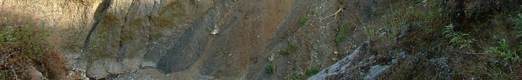
19 Bird s Eye View of Jumjha Slide Close up view of Jumjha Slide Scalin g Net Flexible fence Walls
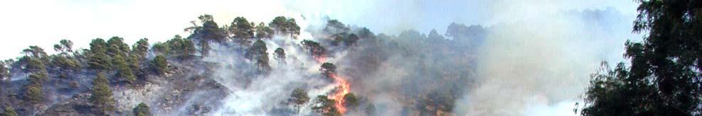
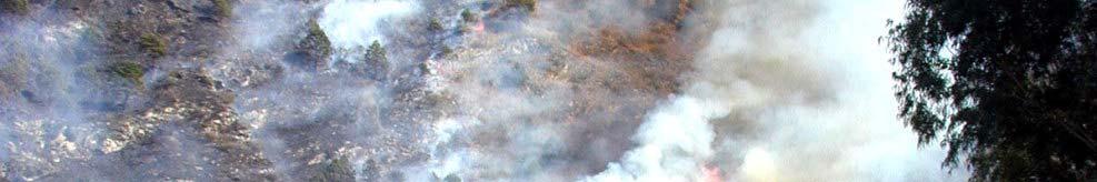
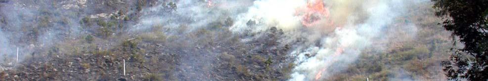
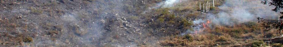
20 Fires on forest and Human settlement. Forest fires Annual event in Bhutan 99.9 % man mademade Fires on human settlement Unsafe habits Electrical wirings, temporary housing. Use of wood Numerous N isolated events.(picnics) i Response: Armed force Volunteer base
21
22
23 Earthquake in the Himalaya Bhutan is located well within the Himalayan Mountain Chains Because of Plate movements, Himalaya still rising in height Sketch showing Indian Plate going underneath Tibetan Plate causing growth of Himalayas & earthquakes.
24 Earthquake History: 4 exceeding 8 on Ritcher scale (1897,1905,1934,1950) 10exceeding 7.5(Himalayanbeltinthe in the last100years) 1980 (6.1, Sikkim) 1988 (6.6, 6 Indo Nepal border) 2003 (5.5, Bhutan) February 2006(5.8 and 5.55 in Bhutan)
25
26 Source: DGM
27 September 21, 2009 earthquake Magnitude 6.1 (2.53 PM local time) Epicenter Narang Monger Duration: 95 Secs Depth: 10 Kms shallow Repeated after schocks Widespread geographical area 13 districts

")


28 Location of September (M6.1) and October (M5.2) 2009 earthquake Sept 21: M=6 6.1 Oct 29: M=5.2


29 Impacts of Sept 21, 2009 Earthquake 4950 households damaged. 422 beyond repair 884 major repair 1335 partial repair 2269 minro repair Cost estimate USD$ 23.3million.


30 281 heritage sites damaged. 539 stops 8 Dzongs Estmated coast of loss is USD$ 13.5million. 45 health centers 117 schools 55 government offices Estimated cost USD$15.8 million


 NNW (343 ) from Shiliguri, West Bengal, India 133")
31 18 September, 2011 Earthquake A portion of the Paro Ta Dzong wall come apart Magnitude 6.8 Date Time Sunday, September 18, 2011 at 12:40:48 UTC Sunday, September 18, 2011 at 06:10:48 PM at epicenter Location N, E Depth 20.7 km (12.9 miles) Region SIKKIM, INDIA Distances 69 km (43 miles) NW (310 ) from Gangtok, Sikkim, India 120 km (74 miles) NNW (343 ) from Shiliguri, West Bengal, India 133 km (83 miles) E (94 ) from Namche Bazar, Nepal 166 km (103 miles) W (278 ) from THIMPHU, Bhutan


32 Families forced to camp outside Cracked/collapsed/damaged in 10 dzongkhags. 329 homes 7 dzongs 19 lhakangs 10 chortens 15 schools 5 BHU/Hospitals/ORC 7 RNR 8 gewog centre/ gup office 6 other infrastructure
33 Other Hazards Wind storms /Thunder storms /Snow storms /Hail storms Epidemics, Pest and Diseases.

.")

34 Cyclone Aila A Flood from Olarongchu River Bhutan is also highly vulnerable to the weather pattern of its southern neighbors. When ever there is depression or cyclone in the Indian State of West Bengal and Bangladesh, there is heavy rainfall in Bhutan. Typical Example Cyclone Aila of May 2009). Bhutan was hit by Cyclone Aila from the Bay of Bengal on May 24,2009 which caused a record breaking average rainfall of 76 mm in the country from May 25, 9 AM to May 26, 9 AM Gasa Hot Springs, the country s most famous hot springs were completely washed away (5 soaking ponds, VIP bathhouse, an outreachclinic clinic, shops, publictoilets, camping ground)


 III.")
35 Adaptation Measures 1. GLOF hazard zonation and vulnerability assessment. To reduce risks onlives and properties downstream through proper planning I. Lunana to Khuruthang: Austro By DGM Austrian Project in 2003 II. Khuruthang Lhamoizingkha (Indo Bhutan Border): DGM under Netherlands Climate Assistance Program (NCAP, 2007) III. Chamkhar valley, Bumthang: DGM in 2007 funded by the Global Environment Facility (GEF).
36 Bajo School New Bajo Town BHU Druk Seed Office Dragon Nest Lunana Glacial Lakes and their Glacial Lake Outburst Floods; Presented to the Cabinet on May 1,
37 Hazard Level Hazard Level High Medium Low Descriptions Persons are in danger both inside and outside their houses. Structures are in danger of being destroyed. Persons are in danger outside their houses. Buildings may suffer damage and possible destruction depending on construction characteristics. Danger to persons is low or non-existent. Buildings may suffer little damages. Lunana Glacial Lakes and their Glacial Lake Outburst Floods; Presented to the Cabinet on May 1,
38 2. Artificial Lowering of Lake water level/mitigation of Lakes at the source To reduce risks at source i. Raphstreng Tso ( ): funded by the Government of India ii. Thorthormi Lake ( ): Planned under the DGM UNDP/GEF Project with funding from LDCF and cofinancers Government of Austria, UNDP, WWF Bhutan and RGoB
39

 Community")


40 3. Installation of Technically Early Warning System (TEWS): To alert people during GLOF and provide enough evacuation time. Early warnings for major river basins are installed. GLOF EWS for Punakha Wangdue basin (DoE & DGM) Community based EWS Sirens installed in Punakha, Khuruthang, Bajothang and Wangdue with the help of UNDP/GEF Funding. Initially there was wireless radio network and satellite phone with DoE personnel in Lunana. Now the mobile connectivity is provided.
41 Installed TEWS Sensor 54 mins 1 hr 24 mins 1hr40mins 2 hrs 14 mins
42 4. Create GLOF Risk Awareness DGM and Disaster Management Division conduct GLOF and early warning system awareness in the country. With the current technology of Bhutan, GLOFs can neither be totally prevented nor predicted and the threats from the GLOF should be taken very seriously.
43 Underlying Vulnerabilities Unsafe construction practices Rapid Urbanization Lack of Enforcement Socio Economic Factors Lack of Awareweness Lack of Preparedness Planning Culture Insurance
44 Functions of Department of Disaster Management National coordinating agency for all DM activities(among all sectors/ agencies/ stakeholders). Institution and functioning of DM institutions. Formulation of guidelines, codes and standards. Facilitate preparation and implementation of all DM plans at all levels. Establishment of disaster communication networks. Capacity building Preparedness, response and recovery. Awareness and advocacy at all levels. l Facilitate mainstreaming of all DRR into development. Collaborationwithall all International, Regional and National Agencies.
45 Emergency Communications: National Emergency Operation Center District Emergency Operation Center Emergency Tele Communication Network System Emergency Transportation
46 Challenges Resource constraint Lack of capacities (Technical Expertise) Multi sectoral coordination Lack of Awareness Peoples attitude Mainstreaming of DRR Response Capacities
47 Conclusions, (GLOF & Landslides) Since GLOF cannot be totally prevented or predicted, the threat from GLOF should be taken seriously. Mitigation measures for risk reduction are planned only along Punatshangchu and Chamkhar a Chu. Most rivers in Bhutan are glacier fed and we have Plans to replicate similar projects in other river basins. For effective land risk management, the potential landslide prone areas should be identified. Delineation of susceptible areas and different types of landslides hazards at a scale will be useful for planning and decision making. At present the hazard prone areas are mapped on 1:50,000 scale, which is not really useful for micro scale infrastructure development. For Earthquake, we can only say that Bhutan is a earthquake prone areas, but we can never say when the earthquake will occur. Measures may be taken by constructing earthquake resilient structures In order to mitigate earthquake risk, Bhutan needs a micro zonation map for the most vulnerable urban cities. Today one building standard is followed across all municipalities. i If we have the micro zonation map the standard d building needed d could be different from one place to another.. We should establish seismic observatories, prepare active fault maps, prepare micro zonation and then develop building codes based on these studies.
48 Thank You
Disaster Management in Bhutan
 ROYAL GOVERNMENT OF BHUTAN Disaster Management in Bhutan Tshering Wangchuk ROYAL GOVERNMENT OF BHUTAN EARTH FIRE WATER AIR ROYAL GOVERNMENT OF BHUTAN Presentation Outline Various Hazards in Bhutan Major
Bhutan Country Report for JPTM 2010 (July, 2010) Department of Disaster Management Ministry of Home & Cultural Affairs Royal Government of Bhutan
 Department of Disaster Management Ministry of Home & Cultural Affairs Royal Government of Bhutan") Bhutan Country Report for JPTM 2010 (July, 2010) Department of Disaster Management Ministry of Home & Cultural Affairs Royal Government of Bhutan 1 Contents of Presentation 1. Disaster Hazards and Underlying
Bhutan Country Report for JPTM 2010 (July, 2010) Department of Disaster Management Ministry of Home & Cultural Affairs Royal Government of Bhutan 1 Contents of Presentation 1. Disaster Hazards and Underlying
DISASTER HAZARDS IN BHUTAN By Tshewang Rinzin January Reducing Disaster Risks for a Safe and Happy Bhutan
 DISASTER HAZARDS IN BHUTAN By Tshewang Rinzin 26-27 January 2009 Reducing Disaster Risks for a Safe and Happy Bhutan Disaster Hazards in Bhutan Earthquakes Glacial Lake Outburst Flood (GLOF) Floods in
Role of Hydro-Met Services in Disaster Risk Management
 Role of Hydro-Met Services in Disaster Risk Management Tshewang Rigzin (Mr) National Centre for Hydrology and Meteorology, Bhutan 30 th November 2017 Outline Vision and Mission Functions related to Disaster
Disaster RISK Management : Bhutanese Scenario
 Disaster RISK Management : Bhutanese Scenario Expert Group Meeting (EGM) on Geo-referenced Information Systems for Disaster Risk Management (Geo-DRM) and sustaining the Community of Practice (COP), Bangkok,
Hazard Zonation for Glacial Lake Outburst Flood (GLOF) in Bhutan Himalaya
 in Bhutan Himalaya") Hazard Zonation for Glacial Lake Outburst Flood (GLOF) in Bhutan Himalaya A mode of Adaptation to the impacts of climate change DGM-NCAP Project Karma Department of Geology & Mines Ministry of Economic
Hazard Zonation for Glacial Lake Outburst Flood (GLOF) in Bhutan Himalaya A mode of Adaptation to the impacts of climate change DGM-NCAP Project Karma Department of Geology & Mines Ministry of Economic
Report on Disaster statistics of Nepal
 Report on Disaster statistics of Nepal Submitted by Altaf Rehman Submitted to Dr. Naveed Ahmed University of engineering and technology Peshawar Assignment 1 Section A Registration id 14PWCIV456 Page 1
- facilitate the preparation of landslide inventory and landslide hazard zonation maps for the city, - development of precipitation thresholds,
 Date of Submission 29.03.2012 IPL Project Proposal Form 2012 (MAXIMUM: 3 PAGES IN LENGTH) 1. Project Title: (2 lines maximum)-introducing Community-based Early Warning System for Landslide Hazard Management
Geographical location and climatic condition of the
 Geographical location and climatic condition of the study sites North eastern region of India is comprised of eight states namely; Arunachal Pradesh, Assam, Manipur, Meghalaya, Mizoram, Nagaland, Sikkim
Natural Disasters in Member Countries (2002 Summary)
") 4.2 Member Countries and their Disaster Characteristics: Table 5: Natural Disasters in Member Countries (2002 Summary) (Country/Disaster Type/Disaster Characteristics) Data Country DisType Count of TotAff
4.2 Member Countries and their Disaster Characteristics: Table 5: Natural Disasters in Member Countries (2002 Summary) (Country/Disaster Type/Disaster Characteristics) Data Country DisType Count of TotAff
SEISMIC RISK ASSESSMENT IN ARMENIA
 SEISMIC RISK ASSESSMENT IN ARMENIA Hovhannes Khangeldyan Head of National Crisis Management Center Rescue Service Ministry of Emergency Situations of the Republic of Armenia Tokyo, 2016 ARMENIA: GEOGRAPHICAL
Geo-information and Disaster Risk Reduction in the Hindu Kush-Himalayan region
 Geo-information and Disaster Risk Reduction in the Hindu Kush-Himalayan region Basanta Shrestha, Division Head MENRIS, International Centre for Integrated Mountain Development Kathmandu, Nepal The International
South Asia Flash Flood Guidance System Operational Workshop (Step-4)
") South Asia Flash Flood Guidance System Operational Workshop (Step-4) (5 th to 7 th June 2018) Operational Flash Flood Forecasting and Early Warnings Capabilities in Bhutan (Sonam Tashi) Weather Forecaster
South Asia Flash Flood Guidance System Operational Workshop (Step-4) (5 th to 7 th June 2018) Operational Flash Flood Forecasting and Early Warnings Capabilities in Bhutan (Sonam Tashi) Weather Forecaster
UNIT 11 SOUTH ASIA SG 1 - PHYSICAL GEOGRAPHY & THE ENVIRONMENT
 UNIT 11 SOUTH ASIA SG 1 - PHYSICAL GEOGRAPHY & THE ENVIRONMENT I. PHYSICAL GEOGRAPHY TAKE OUT YOUR PHYSICAL MAP OF SOUTH ASIA A. The Himalayan Mountains form the northern boundary of the region (color
Word Cards. 2 map. 1 geographic representation. a description or portrayal of the Earth or parts of the Earth. a visual representation of an area
 Name: Date: Hour: Word Cards 1 geographic representation a description or portrayal of the Earth or parts of the Earth Example: A map is a representation of an actual location or place. 2 map a visual
Country Report Nepal Geospatial Data Sharing Initiatives of Survey Department Supporting Disaster Management
 Third JPTM Step 2 for Sentinel Asia 6-8 July, 2010 Manila, The Philippines Country Report Nepal Geospatial Data Sharing Initiatives of Survey Department Supporting Disaster Management Durgendra M Kayastha
West Carroll Parish Hazard Mitigation Plan Update Public Meeting. August 25, 2015 Oak Grove, LA
 West Carroll Parish Hazard Mitigation Plan Update Public Meeting August 25, 2015 Oak Grove, LA Agenda Hazard Mitigation Planning Process SDMI Staff Risk Assessment SDMI Staff Update on Previous/Current
Chapter-3 GEOGRAPHICAL LOCATION, CLIMATE AND SOIL CHARACTERISTICS OF THE STUDY SITE
 Chapter-3 GEOGRAPHICAL LOCATION, CLIMATE AND SOIL CHARACTERISTICS OF THE STUDY SITE Chapter-3 GEOGRAPHICAL LOCATION, CLIMATE AND SOIL CHARACTERISTICS OF THE STUDY SITE Assam, the eastern most state of
EARLY WARNING IN SOUTHERN AFRICA:
 EARLY WARNING IN SOUTHERN AFRICA: Enhancing the Meteorological Early Warning System Eugene Poolman South African Weather Service OUTLINE OF PRESENTATION Impact of Climate Change Meteorological Early Warning
A Presentation By: Dr. G. M. Dar Centre for Disaster Management & Env. Studies, J&K IMPA, Srinagar
 A Presentation By: Dr. G. M. Dar Centre for Disaster Management & Env. Studies, J&K IMPA, Srinagar Introduction Disaster: Sudden or great misfortune. A catastrophe, a calamitous event. Hazards are a natural
Seasonal and annual variation of Temperature and Precipitation in Phuntsholing
 easonal and annual variation of Temperature and Precipitation in Phuntsholing Leki Dorji Department of Civil Engineering, College of cience and Technology, Royal University of Bhutan. Bhutan Abstract Bhutan
Disaster Risk Management in India. Kamal Kishore New Delhi, 27 October 2016
 Disaster Risk Management in India Kamal Kishore New Delhi, 27 October 2016 Hazard, Exposure and Vulnerability Disaster Prevention Mitigation Hurricane Matthew: Cuba & Haiti Emergency Response Coordination
Impact of Cyclone Nargis
 Lessons Learnt from Nargis Recovery for the Next Disaster International Recovery Forum (2011) 12, JAN 2011, Kobe, Japan Home for over 100 national races. Profile of Myanmar The 2 nd largest country in
Residents Emergency Response Checklist
 COMMUNITY RESILIENCE PLAN Residents Emergency Response Checklist A helpful guide in the event of extreme weather or bushfire events. < PREVIOUS I NEXT > 02 Purchasing an existing property or building a
2014 Summer training course for slope land disaster reduction Taipei, Taiwan, Aug
 MINISTRY OF SCIENCE AND TECHNOLOGY HYDROTECH RESEARCH INSTITUTE MINISTRY OF NATURAL RESOURCES AND ENVIRONMENT VIETNAM INSTITUTE OF GEOSCIENCES AND MINERAL RESOURCES (VIGMR) 2014 Summer training course
Kentucky Weather Hazards: What is Your Risk?
 Kentucky Weather Hazards: What is Your Risk? Stuart A. Foster State Climatologist for Kentucky 2010 Kentucky Weather Conference Bowling Green, Kentucky January 16, 2010 Perspectives on Kentucky s Climate
MEGACITIES AND DISASTER RISK - THE CASE OF MUMBAI
 Municipal Corporation of Greater Mumbai, India MEGACITIES AND DISASTER RISK - THE CASE OF MUMBAI Presentation by S S KSHATRIYA Municipal Commissioner MUMBAI Largest city in India 6 th Largest metropolis
MODELLING FROST RISK IN APPLE TREE, IRAN. Mohammad Rahimi
 WMO Regional Seminar on strategic Capacity Development of National Meteorological and Hydrological Services in RA II (Opportunity and Challenges in 21th century) Tashkent, Uzbekistan, 3-4 December 2008
Geography Class XI Fundamentals of Physical Geography Section A Total Periods : 140 Total Marks : 70. Periods Topic Subject Matter Geographical Skills
 Geography Class XI Fundamentals of Physical Geography Section A Total Periods : 140 Total Marks : 70 Sr. No. 01 Periods Topic Subject Matter Geographical Skills Nature and Scope Definition, nature, i)
Disaster Management and Spatial Data An Experience of Sri Lanka for Joint project team meeting 2012
 Disaster Management and Spatial Data An Experience of Sri Lanka for Joint project team meeting 2012 1 by Padma Kumara Withana Provincial Surveyor General Uva Province 2 Out line ü Introduction ü Natural
Emergency Preparedness Questions
 Emergency Preparedness Questions 1. A family emergency plan should NOT include which of the following? a) Information about your children's school(s) b) The name and phone number of an out-of-town contact
LECTURE #15: Thunderstorms & Lightning Hazards
 GEOL 0820 Ramsey Natural Disasters Spring, 2018 LECTURE #15: Thunderstorms & Lightning Hazards Date: 1 March 2018 (lecturer: Dr. Shawn Wright) I. Severe Weather Hazards focus for next few weeks o somewhat
Paper Reference. Paper Reference(s) 1312/4H Edexcel GCSE Geography A Higher Tier. Monday 11 June 2007 Afternoon Time: 1 hour 15 minutes
 1312/4H Edexcel GCSE Geography A Higher Tier. Monday 11 June 2007 Afternoon Time: 1 hour 15 minutes") Centre No. Paper Reference Surname Initial(s) Candidate No. 1 3 1 2 4 H Signature Paper Reference(s) 1312/4H Edexcel GCSE Geography A Higher Tier Paper 4H Monday 11 June 2007 Afternoon Time: 1 hour 15
Centre No. Paper Reference Surname Initial(s) Candidate No. 1 3 1 2 4 H Signature Paper Reference(s) 1312/4H Edexcel GCSE Geography A Higher Tier Paper 4H Monday 11 June 2007 Afternoon Time: 1 hour 15
Vulnerability of Bangladesh to Cyclones in a Changing Climate
 Vulnerability of Bangladesh to Cyclones in a Changing Climate Susmita Dasgupta Kiran Pandey Mainul Huq Zahirul Huq Khan M.M. Zahid Ahmed Nandan Mukherjee Malik Fida Khan 2010 Bangladesh: Tropical Cyclone
Physical Geography of East Asia
 Physical Geography of East Asia Satellite View of China Landforms of China China s Geography China Miles 0 250 500 1,000 1,500 2,000 United States 3 rd largest country in the world. Comparable to the US
Unit 2 Text Worksheet # 2
 Unit 2 Text Worksheet # 2 Read Pages 74-77 1. Using fig. 5.1 on page 75 identify: Climatic Region the most widespread climatic region in the low latitudes two climatic subregions with dry conditions for
Table G - 6. Mitigation Actions Identified for Implementation by the City of Kent ( ) (From Wilkin County Master Mitigation Action Chart)
 (From Wilkin County Master Mitigation Action Chart)") Table G - 6. Actions Identified by the () (From Master Action Chart) Multi-Hazard Plan, 2017 Action Comments 5 All-Hazards Local Planning & Regulations Update the Operations Plan on an annual basis. Work
Table G - 6. Actions Identified by the () (From Master Action Chart) Multi-Hazard Plan, 2017 Action Comments 5 All-Hazards Local Planning & Regulations Update the Operations Plan on an annual basis. Work
RISK OF PRINCIPAL DISASTERS IN INDIA AND IMPACTS OF DISASTERS ON ECONOMIC DEVELOPMENT
 RISK OF PRINCIPAL DISASTERS IN INDIA AND IMPACTS OF DISASTERS ON ECONOMIC DEVELOPMENT At the Himachal Pradesh Institute of Public Administration Shimla 05. 05.2012 Improve Disaster Management with the
Georeferencing and Satellite Image Support: Lessons learned, Challenges and Opportunities
 Georeferencing and Satellite Image Support: Lessons learned, Challenges and Opportunities Shirish Ravan shirish.ravan@unoosa.org UN-SPIDER United Nations Office for Outer Space Affairs (UNOOSA) UN-SPIDER
Disclaimer. This report was compiled by an ADRC visiting researcher (VR) from ADRC member countries.
 from ADRC member countries.") Disclaimer This report was compiled by an ADRC visiting researcher (VR) from ADRC member countries. The views expressed in the report do not necessarily reflect the views of the ADRC. The boundaries and
Disclaimer This report was compiled by an ADRC visiting researcher (VR) from ADRC member countries. The views expressed in the report do not necessarily reflect the views of the ADRC. The boundaries and
Project on Seismic Hazard & Vulnerability. areas, Bangladesh. Mohammad Ashraful Kamal (Geologist)
") Project on Seismic Hazard & Vulnerability Assessment in Dhaka, Chittagong & Sylhet city areas, Bangladesh By Mohammad Ashraful Kamal (Geologist) Tectonic & Seismic zoning map of Bangladesh Geological map
Project on Seismic Hazard & Vulnerability Assessment in Dhaka, Chittagong & Sylhet city areas, Bangladesh By Mohammad Ashraful Kamal (Geologist) Tectonic & Seismic zoning map of Bangladesh Geological map
Summary of the Presentation
 CBMS & GIS Utilization in Planning for Disaster Risk Reduction & Management (DRRM) and Climate Change Adaptation (CCA) Presented by: ENGR. MARIVIC J. NIERRAS, EnP Planning Officer IV and Officer-In-Charge
Use of Geospatial data for disaster managements
 Use of Geospatial data for disaster managements Source: http://alertsystemsgroup.com Instructor : Professor Dr. Yuji Murayama Teaching Assistant : Manjula Ranagalage What is GIS? A powerful set of tools
General Characteristics of the Country
 Chapter 2 General Characteristics of the Country 2.1 PHYSICAL FEATURES Bhutan is situated in the eastern Himalayas between the latitudes 26 45 N to 28 10 N and longitudes 88 45 E to 92 10 E. It is 340
Recent development of the National Hydro-Meteorological Service (NHMS) of Viet Nam for disaster risk reduction
 of Viet Nam for disaster risk reduction") Ministry of Natural Resources and Environment National Hydro-Meteorological Service Recent development of the National Hydro-Meteorological Service (NHMS) of Viet Nam for disaster risk reduction Tran Van
Ministry of Natural Resources and Environment National Hydro-Meteorological Service Recent development of the National Hydro-Meteorological Service (NHMS) of Viet Nam for disaster risk reduction Tran Van
The Impact of Geography in South and East Asia
 The Impact of Geography in South and East Asia Gobi desert, Mongolia Essential Question: How does geography impact the distribution of population throughout South and East Asia? I CAN Explain how geography
The Impact of Geography in South and East Asia
 The Impact of Geography in South and East Asia Gobi desert, Mongolia Essential Question: How does the geography of SE Asia impact trade and the distribution of population throughout the region? (AKS #52a)
MULTI-HAZARD RISK ASSESSMENT AND DECISION MAKING
 MULTI-HAZARD RISK ASSESSMENT AND DECISION MAKING JULINDA KEÇI Epoka University Logo of the institution CONTENT: Introduction Multi Hazard Risks Multi-Hazard Risk Assessment Quantitative Assessment Event
Progress Report. Flood Hazard Mapping in Thailand
 Progress Report Flood Hazard Mapping in Thailand Prepared By: Mr. PAITOON NAKTAE Chief of Safety Standard sub-beuro Disaster Prevention beuro Department of Disaster Prevention and Mitigation THAILAND E-mail:
By Lillian Ntshwarisang Department of Meteorological Services Phone:
 By Lillian Ntshwarisang Department of Meteorological Services Phone: +267 3612200 Email: lntshwarisang@gov.bw/ lntshwarisang@gmail.com Introduction Mandate of DMS Function of the Department Services to
Bossier Parish Hazard Mitigation Plan Update Public Meeting. August 10, 2016 Bossier City, LA
 Bossier Parish Hazard Mitigation Plan Update Public Meeting August 10, 2016 Bossier City, LA Agenda Hazard Mitigation Planning Process SDMI Staff Risk Assessment SDMI Staff Update on Previous/Current Mitigation
Weather and Climate 1. Elements of the weather
 Weather and Climate 1 affect = to have an effect on, influence, change altitude = the height of a place above the sea axis = the line around which an object rotates certain = special consist of = to be
Pacific Catastrophe Risk Assessment And Financing Initiative
 Pacific Catastrophe Risk Assessment And Financing Initiative TIMOR-LESTE September Timor-Leste is expected to incur, on average, 5.9 million USD per year in losses due to earthquakes and tropical cyclones.
IN VEHICLES: Do not try to outrun a tornado. Abandon your vehicle and hide in a nearby ditch or depression and cover your head.
 TORNADO SAFETY TORNADO! The very word strikes fear in many people. While a tornado is perhaps nature's most destructive storm, deaths and injuries can be prevented. By following Tornado Safety Rules, lives
California: Land and People Lesson 1: Locating California
 California: Land and People Lesson 1: Locating California Hemisphere One half of the earth or another sphere Video on Hemispheres click here Relative location Where a place is compared to one or more other
COUNTRY PRESENTATION ON MR JAYNAL ABEDIN JOINT SECRETARY ( WORKS & DEVELOPMENT ) MINISTRY OF DEFENCE
 MINISTRY OF DEFENCE") COUNTRY PRESENTATION ON By MR JAYNAL ABEDIN JOINT SECRETARY ( WORKS & DEVELOPMENT ) MINISTRY OF DEFENCE Bangladesh Geographical Location of Bangladesh Bangladesh Country at a Glance Physical Features 1,230
COUNTRY PRESENTATION ON By MR JAYNAL ABEDIN JOINT SECRETARY ( WORKS & DEVELOPMENT ) MINISTRY OF DEFENCE Bangladesh Geographical Location of Bangladesh Bangladesh Country at a Glance Physical Features 1,230
UIB Network - TWG 5 Hazards and risks:
 UIB Network - TWG 5 Hazards and risks: Philippus Wester & Muhammad Asif Khan ICIMOD & Karakoram International university TWG-5 members: Arun Shrestha, Liu Shiyin, Nusrat Nasab, Deedar Karim, Muhammad Zafar
CLIMATE CHANGE ASSESSMENT. A. Climate Change Risk Assessment and Adaptation Measures
 Solar Transmission Sector Project (RRP IND 49214) CLIMATE CHANGE ASSESSMENT I. Transmission System at Bhadla, Rajasthan A. Climate Change Risk Assessment and Adaptation Measures High temperature Risk is
Flood Inundation Mapping under different climate change scenarios in the upper Indus River Basin, Pakistan
 Flood Inundation Mapping under different climate change scenarios in the upper Indus River Basin, Pakistan Sohaib Baig (doctoral student) 16 November 2017 Disaster Prevention Research Institute 1 Kyoto
Chapter 1 Section 2. Land, Water, and Climate
 Chapter 1 Section 2 Land, Water, and Climate Vocabulary 1. Landforms- natural features of the Earth s land surface 2. Elevation- height above sea level 3. Relief- changes in height 4. Core- most inner
They include earthquakes, volcanic eruptions, floods, landslides, and other processes and occurrences. They are included in the broader concept of.
 They include earthquakes, volcanic eruptions, floods, landslides, and other processes and occurrences. They are included in the broader concept of. In general, natural processes are labeled hazardous only
Joint Meeting of RA II WIGOS Project and RA V TT-SU on 11 October 2018 BMKG Headquarter Jakarta, Indonesia. Mrs. Sinthaly CHANTHANA
 Joint Meeting of RA II WIGOS Project and RA V TT-SU on 11 October 2018 BMKG Headquarter Jakarta, Indonesia Mrs. Sinthaly CHANTHANA Lao PDR Background Department of Meteorology and Hydrology ( DMH ) in
Workshop on Drought and Extreme Temperatures: Preparedness and Management for Sustainable Agriculture, Forestry and Fishery
 Workshop on Drought and Extreme Temperatures: Preparedness and Management for Sustainable Agriculture, Forestry and Fishery 16-17 Feb.2009, Beijing, China Modeling Apple Tree Bud burst time and frost risk
DIPLOMA IN DISASTER MANAGEMENT. (Non-Semester) (With effect from the academic year )
 (With effect from the academic year )") DIPLOMA IN DISASTER MANAGEMENT (Non-Semester) (With effect from the academic year 2013-14) Eligibility for the Course Candidate should have passed the Higher Secondary Examination conducted by the Board
DIPLOMA IN DISASTER MANAGEMENT (Non-Semester) (With effect from the academic year 2013-14) Eligibility for the Course Candidate should have passed the Higher Secondary Examination conducted by the Board
Initiative. Country Risk Profile: papua new guinea. Better Risk Information for Smarter Investments PAPUA NEW GUINEA.
 Pacific Catastrophe Risk Assessment And Financing Initiative PAPUA NEW GUINEA September 211 Country Risk Profile: papua new is expected to incur, on average, 85 million USD per year in losses due to earthquakes
How strong does wind have to be to topple a garbage can?
 How strong does wind have to be to topple a garbage can? Imagine winds powerful enough to pick up a truck and toss it the length of a football field. Winds of this extreme sometimes happen in a tornado.
Data challenges in Trans-boundary River Basins: Case Study of the Upper Indus Basin
 Data challenges in Trans-boundary River Basins: Case Study of the Upper Indus Basin Asif Khan Lead Author (Water chapter- AR6 IPCC) Post Doctorate (Water-Energy-Food-Climate Change, IIASA, Austria) PhD
Extreme Weather Events: Infrastructure Damage and Impact on Vulnerable Populations
 Extreme Weather Events: Infrastructure Damage and Impact on Vulnerable Populations Cindy L. Parker MD, MPH Physicians for Social Responsibility Johns Hopkins Bloomberg School of Public Health 1 Climate
A Living Planet. The Earth Inside and Out
 A Living Planet The Earth Inside and Out Planet Earth Earth s Rotation, Revolution, and Tilt Most of Earth s energy comes from the Sun, which we call solar energy. Imagine that the Earth has an imaginary
DISASTERS IN MONGOLIA
 DISASTERS IN MONGOLIA ADRC Visiting Researcher Ms. Sh.Altanchimeg Kobe, 0Japan March, 2007 Mongolia is located in Asia, between China and Russia 1 1 Territory: 1,564,619 sq. km Population : 2,500,000.
5.2. IDENTIFICATION OF NATURAL HAZARDS OF CONCERN
 5.2. IDENTIFICATION OF NATURAL HAZARDS OF CONCERN To provide a strong foundation for mitigation strategies considered in Sections 6 and 9, County considered a full range of natural hazards that could impact
KNOWLEDGE NOTE 5-1. Risk Assessment and Hazard Mapping. CLUSTER 5: Hazard and Risk Information and Decision Making. Public Disclosure Authorized
 Public Disclosure Authorized Public Disclosure Authorized Public Disclosure Authorized Public Disclosure Authorized KNOWLEDGE NOTE 5-1 CLUSTER 5: Hazard and Risk Information and Decision Making Risk Assessment
Paper Reference. Paper Reference(s) 1312/2F Edexcel GCSE Geography A Foundation Tier. Monday 11 June 2007 Afternoon Time: 1 hour 15 minutes
 1312/2F Edexcel GCSE Geography A Foundation Tier. Monday 11 June 2007 Afternoon Time: 1 hour 15 minutes") Centre No. Paper Reference Surname Initial(s) Candidate No. 1 3 1 2 2 F Signature Paper Reference(s) 1312/2F Edexcel GCSE Geography A Foundation Tier Paper 2F Monday 11 June 2007 Afternoon Time: 1 hour
Centre No. Paper Reference Surname Initial(s) Candidate No. 1 3 1 2 2 F Signature Paper Reference(s) 1312/2F Edexcel GCSE Geography A Foundation Tier Paper 2F Monday 11 June 2007 Afternoon Time: 1 hour
Table-Top Exercise for Emergency Preparedness Evaluation: Little Anse, Isle Madame
 Table-Top Exercise for Emergency Preparedness Evaluation: Little Anse, Isle Madame Alexander Chung, M.Sc. Candidate C-Change Student Research Associate May 2013 The Community of Little Anse Coastal community
1.0 Introduction 1.1 Geographic Location 1.2 Topography 1.3 Climate and Rainfall 1.4 Geology and Hydrogeology 1.5 Water Availability 1.
 1.0 1.1 Geographic Location 1.2 Topography 1.3 Climate and Rainfall 1.4 Geology and Hydrogeology 1.5 Water Availability 1.6 Demography 1.0 1.1 Geographic Location St. Lucia forms part of an archipelago
STEUBEN COUNTY, NEW YORK. Hazard Analysis Report
 STEUBEN COUNTY, NEW YORK Hazard Analysis Report Prepared by: April 1, 2014 Background On April 1, 2014 the Steuben County Office of Emergency Management conducted a hazard analysis using the automated
GENERAL. CHAPTER 1 BACKGROUND AND PURPOSE OF THE GUIDELINES Background of the Guidelines Purpose of the Guidelines...
 GENERAL CHAPTER 1 BACKGROUND AND PURPOSE OF THE GUIDELINES... 1 1.1 Background of the Guidelines... 1 1.2 Purpose of the Guidelines... 3 CHAPTER 2 APPLICATION OF THE GUIDELINES... 3 2.1 Potential Users
Chapter 4 Hydrodynamic Modelling of Glacial Lake Outburst Floods
 Chapter 4 Hydrodynamic Modelling of Glacial Lake Outburst Floods To better understand the impacts that a GLOF can have on the downstream valleys, an attempt was made to simulate one GLOF event each in
Use of Climate information in Disaster Risk Management in Zimbabwe
 Use of Climate information in Disaster Risk Management in Zimbabwe WMO Regional Technical Meeting & User/CONOPS Workshop, 28 th October 2015 Lameck Betera Department of Civil Protection Institutional Arrangements
RISK ASSESSMENT COMMUNITY PROFILE NATURAL HAZARDS COMMUNITY RISK PROFILES. Page 13 of 524
 RISK ASSESSMENT COMMUNITY PROFILE NATURAL HAZARDS COMMUNITY RISK PROFILES Page 13 of 524 Introduction The Risk Assessment identifies and characterizes Tillamook County s natural hazards and describes how
2014 Russell County Hazard Mitigation Plan Update STAKEHOLDERS AND TECHNICAL ADVISORS MEETING 2/6/14
 2014 Russell County Hazard Mitigation Plan Update STAKEHOLDERS AND TECHNICAL ADVISORS MEETING 2/6/14 Welcome and Introductions We cannot direct the wind, but we can adjust our sails. 44 CFR 201.6; Local
INDONESIA IMPACT BASED FORECAST PROGRAM
 INDONESIA IMPACT BASED FORECAST PROGRAM Seoul, 19-21 November 2018 The 2nd Regional Workshop on Impact-based Forecasts in Asia Indonesia Agency for Meteorology Climatology and Geophysics (BMKG) A. Fachri
This report was produced and issued by OCHA Pakistan. It provides an overview of the monsoon flood situation as of 22 July 2015.
 Pakistan: Monsoon 2015 Update No. 1 (as of 22 July 2015) This report was produced and issued by OCHA Pakistan. It provides an overview of the monsoon flood situation as of 22 July 2015. Heavy monsoon rains,
2014 Annual Mitigation Plan Review Meeting
 2014 Annual Mitigation Plan Review Meeting Highland County EMA MEETING OBJECTIVES Understand Your Natural Disaster Risk Review of Previous Plans Current Plan Status Future Activity Plan/Needs of Each Community
Flooding in Western North Carolina: Some Spatial, Hydrologic, and Seasonal Characteristics CAUTION!! Outline. Basic Flood Facts.
 Flooding in Western North Carolina: Some Spatial, Hydrologic, and Seasonal Characteristics J. Greg Dobson CAUTION!! National Environmental Modeling and Analysis Center RENCI at UNC-Asheville Engagement
investment decisions
 Climate modelling: A guide to investment decisions Vicky Pope Met Office Hadley Centre This is not an ADB material. The views expressed in this document are the views of the author/s and/or their organizations
Pacific Catastrophe Risk Assessment And Financing Initiative
 Pacific Catastrophe Risk Assessment And Financing Initiative TUVALU is expected to incur, on average,. million USD per year in losses due to earthquakes and tropical cyclones. In the next 5 years, has
National Public Weather and Warning Services in the Swaziland Meteorological Service Dennis S.Mkhonta /
 National Public Weather and Warning Services in the Swaziland Meteorological Service Dennis S.Mkhonta dennis.mkhonta@gmail.com / dennis@swazimet.gov.sz Introduction Swaziland s geographical position exposes
Year 4 Geography Revision Pack Summer 2018 Name
 Year 4 Geography Revision Pack Summer 2018 Name Welcome to your geography revision pack for the upcoming Summer exams. Everything that we have been working on in lessons since Christmas will be covered
South, Southeast, and East Asia. Physical Geography
 South, Southeast, and East Asia Physical Geography Mountains v Mountains are important in Asia because they influence: A. Population patterns B. Movement of people and goods C. Climate Mountains v The
3. HYDROMETEROLOGY. 3.1 Introduction. 3.2 Hydro-meteorological Aspect. 3.3 Rain Gauge Stations
 3. HYDROMETEROLOGY 3.1 Introduction Hydrometeorology is a branch of meteorology and hydrology that studies the transfer of water and energy between the land surface and the lower atmosphere. Detailed hydrological
What Are Disasters? The Rescue Kids Trio!
 The Rescue Kids Trio! What Are Disasters? This manual was made possible through funding by the Council of Local Authorities for International Relations. Disasters and emergency preparedness Emergency preparedness
Weather. A. atmosphere is a layer of gases that wrap around the Earth like a blanket.
 Weather I. The air around us A. atmosphere is a layer of gases that wrap around the Earth like a blanket. II. Weather Temperature Humidity Air pressure Wind 1. contains the air we breathe, protects us
HAZARD DESCRIPTION... 1 LOCATION... 1 EXTENT... 1 HISTORICAL OCCURRENCES...
 WINTER STORM HAZARD DESCRIPTION... 1 LOCATION... 1 EXTENT... 1 HISTORICAL OCCURRENCES... 3 SIGNIFICANT PAST EVENTS... 4 PROBABILITY OF FUTURE EVENTS... 5 VULNERABILITY AND IMPACT... 5 Hazard Description
Report. Developing a course component on disaster management
 Report Developing a course component on disaster management By Chira Prangkio Tawee Chaipimonplin Department of Geography, Faculty of Social Sciences, Chiang Mai University Thailand Presented at Indian
The weather in Iceland 2012
 The Icelandic Meteorological Office Climate summary 2012 published 9.1.2013 The weather in Iceland 2012 Climate summary Sunset in Reykjavík 24th April 2012 at 21:42. View towards west from the balcony
Tropical Moist Rainforest
 Tropical or Lowlatitude Climates: Controlled by equatorial tropical air masses Tropical Moist Rainforest Rainfall is heavy in all months - more than 250 cm. (100 in.). Common temperatures of 27 C (80 F)
Geohazards and disaster risk reduction
 Geohazards and disaster risk reduction Susanne Sargeant 8 November 2017 Overview University and my PhD Seismology at BGS Learning other skills Working at the interface between science and resilience building
Fire Weather Drivers, Seasonal Outlook and Climate Change. Steven McGibbony, Severe Weather Manager Victoria Region Friday 9 October 2015
 Fire Weather Drivers, Seasonal Outlook and Climate Change Steven McGibbony, Severe Weather Manager Victoria Region Friday 9 October 2015 Outline Weather and Fire Risk Environmental conditions leading to
TABLE OF CONTENTS LIST OF TABLES. Page
 TABLE OF CONTENTS Page 11.0 EFFECTS OF THE ENVIRONMENT ON THE PROJECT... 11-1 11.1 Weather Conditions... 11-1 11.2 Flooding... 11-2 11.3 Forest Fires... 11-2 11.4 Permafrost and Subsidence Risk... 11-3