Strong Aftershocks Continue to Affect Japan
|
|
|
- Chester Lee
- 5 years ago
- Views:
Transcription

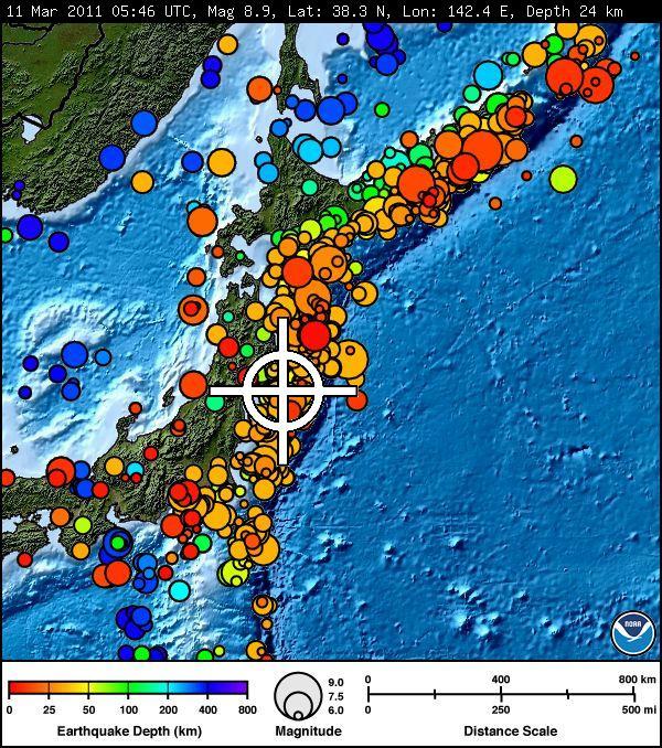
1 Strong Aftershocks Continue to Affect Japan MARCH 11, :05 AM UTC UPDATED: MARCH 12, :28 PM UTC FILED UNDER EARTHQUAKE, JAPAN There have been hundreds of aftershocks following the devastating magnitude 8.9 earthquake that struck off the East Coast of Japan on March 11. More than two dozen are greater than magnitude 6, the size of the earthquake that severely damaged Christchurch, NZ last month. Learn more CATEGORIES BIOLOGY CLIMATE CHANGE ECOSYSTEMS
2 ENERGY AND MINERALS GEOGRAPHY GEOLOGY JUST IN GENERAL NATURAL HAZARDS ORGANIZATIONAL WATER WILDLIFE AND HUMAN HEALTH Related Posts: Hot Times Continue on Hawai`i Island Groundwater Awareness Week, March 6-12, 2011 Help Shape the Future of Our Ecosystems Science What's Water Doing Underground? Gone With the Wind NEAR EAST COAST OF HONSHU, JAPAN Friday, March 11, 2011 at 05:46:23 (UTC) - Coordinated Universal Time Friday, March 11, 2011 at 02:46:23 PM - Local Time at Epicenter North America:: Friday, March 11, 2011 at 02:16:23 AM (NST) - Newfoundland Standard (St. John's) Friday, March 11, 2011 at 01:46:23 AM (AST) - Atlantic Standard (Halifax, San Juan) Friday, March 11, 2011 at 12:46:23 AM (EST) - Eastern Standard (New York, Toronto, Jamaica) Thursday, March 10, 2011 at 11:46:23 PM (CST) - Central Standard (Chicago, Mexico City, Costa Rica) Thursday, March 10, 2011 at 10:46:23 PM (MST) - Mountain Standard (Calgary, Denver, Phoenix) Thursday, March 10, 2011 at 09:46:23 PM (PST) - Pacific Standard (Vancouver, Los Angeles, Tijuana) Thursday, March 10, 2011 at 08:46:23 PM - Anchorage Thursday, March 10, 2011 at 07:46:23 PM - Adak Thursday, March 10, 2011 at 07:46:23 PM -
3 Honolulu South America:: Friday, March 11, 2011 at 12:46:23 AM - Bogota, Quito, Lima Friday, March 11, 2011 at 01:16:23 AM - Caracas Friday, March 11, 2011 at 01:46:23 AM - Manaus, La Paz Friday, March 11, 2011 at 02:46:23 AM - Belem, Buenos Aires, Santiago, Rio de Janeiro, Sao Paulo Friday, March 11, 2011 at 03:46:23 AM - Montevideo Europe:: Friday, March 11, 2011 at 05:46:23 AM - London, Lisbon Friday, March 11, 2011 at 06:46:23 AM - Madrid, Rome, Berlin, Warsaw Friday, March 11, 2011 at 07:46:23 AM - Kiev, Istanbul, Athens Friday, March 11, 2011 at 08:46:23 AM - Moscow, Saint Petersburg Africa:: Friday, March 11, 2011 at 05:46:23 AM - Casablanca, Abidjan Friday, March 11, 2011 at 06:46:23 AM - Algiers, Lagos, Kinshasa Friday, March 11, 2011 at 07:46:23 AM - Cairo, Lusaka, Cape Town Friday, March 11, 2011 at 08:46:23 AM - Addis Ababa, Nairobi Asia:: Friday, March 11, 2011 at 07:46:23 AM - Anakara, Damascus Friday, March 11, 2011 at 08:46:23 AM - Baghdad, Riyadh, Samara Friday, March 11, 2011 at 09:16:23 AM - Tehran, Mashhad Friday, March 11, 2011 at 09:46:23 AM - Baku, Tbilisi, Muscat Friday, March 11, 2011 at 10:16:23 AM - Kabul Friday, March 11, 2011 at 10:46:23 AM - Yekaterinburg, Tashkent, Karachi Friday, March 11, 2011 at 11:16:23 AM - Delhi, Bombay, Calcutta Friday, March 11, 2011 at 11:46:23 AM - Novosibirsk, Almaty, Dhaka Friday, March 11, 2011 at 12:46:23 PM - Krasnoyarsk, Bangkok, Jakarta Friday, March 11, 2011 at 01:46:23 PM - Irkutsk, Beijing, Manilla, Singapore Friday, March 11, 2011 at 02:46:23 PM - Chita, Seoul, Tokyo Friday, March 11, 2011 at 03:46:23 PM - Vladivostok, Guam Friday, March 11, 2011 at 04:46:23 PM - Magadan, Petropavlovsk-Kamchatskiy Australasia/Oceania:: Thursday, March 10, 2011 at 06:46:23 PM - American Samoa Thursday, March 10, 2011 at 07:46:23 PM - Tahiti Friday, March 11, 2011 at 01:46:23 PM - Perth Friday, March 11, 2011 at 03:16:23 PM - Darwin Friday, March 11, 2011 at 03:46:23 PM - Port Moresby, Brisbane Friday, March 11, 2011 at 04:16:23 PM - Adelaide Friday, March 11, 2011 at 04:46:23


 near the east coast of Honshu,")


4 PM - Sydney, Melbourne, Solomon Islands, Vanuatu Friday, March 11, 2011 at 05:46:23 PM - Fiji Friday, March 11, 2011 at 06:46:23 PM - Auckland, Christchurch Earthquake Summary Earthquake Summary Poster Tectonic Summary Versión en Español The 03/11/2011 earthquake (preliminary magnitude 8.9) near the east coast of Honshu, Japan, occurred as a result of thrust faulting on or near the subduction zone interface plate boundary between the Pacific and North America plates. At the latitude of this earthquake, the Pacific plate moves approximately westwards with respect to the North America plate at a velocity of 83 mm/yr. The Pacific plate thrusts underneath Japan at the Japan Trench, and dips to
5 the west beneath Eurasia. The location, depth, and focal mechanism of the March 11 earthquake are consistent with the event having occurred as thrust faulting associated with subduction along this plate boundary. Note that some authors divide this region into several microplates that together define the relative motions between the larger Pacific, North America and Eurasia plates; these include the Okhotsk and Amur microplates that are respectively part of North America and Eurasia. The March 11 earthquake was preceded by a series of large foreshocks over the previous two days, beginning on March 9th with an M 7.2 event approximately 40 km from the March 11 earthquake, and continuing with a further 3 earthquakes greater than M 6 on the same day. The Japan Trench subduction zone has hosted 9 events of magnitude 7 or greater since The largest of these was an M 7.8 earthquake approximately 260 km to the north of the March 11 event, in December 1994, which caused 3 fatalities and almost 700 injuries. In June of 1978, an M 7.7 earthquake 35 km to the southwest caused 22 fatalities and over 400 injuries. Earthquake Information for Asia Earthquake Information for Japan Seismicity of the Earth 1900 to 2007, Japan and Vicinity Map USGS Audio CoreCast Interview with Seismologists Bill Ellsworth and Eric Geist Historic USGS Moment Tensor Solutions


6 M a g n it u d e 8. 9 NEAR EAST COAST OF HONSHU, JAPAN Friday, March 11, 2011 at 05:46:23 UTC
7 Major Tectonic Boundaries: Subduction Zones -purple, Ridges -red and Transform Faults -green The most recent (20 or less) USGS Moment Tensor Solutions are shown. Data from the Source Parameter Database.
8 Latest USGS Fast Moment Tensor Solutions Preliminary Earthquake Report U.S. Geological Survey, National Earthquake Information Center World Data Center for Seismology, Denver
9
Magnitude 7.1 NEAR THE EAST COAST OF HONSHU, JAPAN
 Japan was rattled by a strong aftershock and tsunami warning Thursday night nearly a month after a devastating earthquake and tsunami flattened the northeastern coast. This earthquake can be considered
nd STREET, MENOMINEE, MICHIGAN 49858
 2209 22 nd STREET, MENOMINEE, MICHIGAN 49858 DATE: May 4, 2009 SERVICE INFORMATION LETTER NO. T-035 Page 1 of 9 1. SUBJECT: Identifying Corrosion Severity Zone for Operating Environment 2. MODEL: TH-28,
Latitude & Longitude. Worksheets & activities to teach latitude & longitude. Includes notes, activities, review & all answer keys. 11 pages!
 Latitude & Longitude Worksheets & activities to teach latitude & longitude. Includes notes, activities, review & all answer keys. 11 pages! Lines of Latitude & Longitude Name: Lines of latitude and longitude
Meeting the Challenges of Earthquake Risk Dynamics and Globalisation
 Check Against Delivery. Embargoed until 4:15 PM, 5 November 2010 Meeting the Challenges of Earthquake Risk Dynamics and Globalisation by Jochen Zschau GFZ German Research Centre for Geosciences, Potsdam,
Tsunami waves swept away houses and cars in northern Japan and pushed ships aground.
 Japan was struck by a magnitude 8.9 earthquake off its northeastern coast Friday. This is one of the largest earthquakes that Japan has ever experienced. In downtown Tokyo, large buildings shook violently
Magnitude 7.5 NEW BRITAIN REGION, PAPUA NEW GUINEA
 A magnitude 7.5 earthquake struck off the eastern coast of Papua New Guinea on Tuesday, approximately 130 km (81 mi) southsouthwest of Kokopo at a depth of 42 km (26.1 mi). There are reports of some structural
Magnitude 7.0 VANUATU
 A major earthquake struck in the southwest Pacific Ocean at a depth of 27 km beneath the island of Melampa in the Vanuatu island chain. There are no reports of damage. The Modified Mercalli Intensity (MMI)
10.2 Fitting a Linear Model to Data
 Name Class Date 10.2 Fitting a Linear Model to Data Essential Question: How can you use the linear regression function on a graphing calculator to find the line of best fit for a two-variable data set?
Magnitude 7.0 PAPUA, INDONESIA
 A 7.0 magnitude earthquake struck eastern Indonesia's mountainous West Papua province on Saturday but there were no immediate reports of casualties or damage. The region is sparsely populated. According
Magnitude 8.3 SEA OF OKHOTSK
 A powerful earthquake in Russia's Far East was felt as far away as Moscow, about 7,000 kilometers (4,400 miles) west of the epicenter, but no casualties or damage were reported. The epicenter was in the
Hazard and Vulnerability of Moderate Seismicity Regions
 Hazard and Vulnerability of Moderate Seismicity Regions presented by Professor Tso-Chien PAN Dean, College of Engineering Director, 25 October 2010 DRM GDLN Session on Earthquake Vulnerability Reduction
Magnitude 7.0 NEW CALEDONIA
 A magnitude 7.0 earthquake has occurred 82km ENE of Maré Island, the secondlargest of the Loyalty Islands in the archipelago of New Caledonia. The initial report of the magnitude and shallow 10km depth
Magnitude 6.9 GULF OF CALIFORNIA
 A pair of strong earthquakes struck off the coast of Mexico early Thursday only minutes apart. The magnitude 6.9 and 6.2 were centered about 85 miles northeast of Guerrero Negro in the Mexican state of
Magnitude 7.0 PERU. This region of the Andes is a sparsely populated area, there were no immediate reports of injuries or damage.
 A magnitude 7.0 earthquake occurred in southeastern Peru on Friday about 27 kilometers northeast of the town of Azángaro, Peru, near the border with Bolivia. The earthquake occurred at a depth of 257.4
Magnitude 7.3 OFFSHORE EL SALVADOR
 A magnitude 7.3 earthquake struck off the Pacific coast of Central America late Monday night, early reports indicate one death. The earthquake occurred at a depth of 40 km (24.9 miles). Its epicenter was
CAL. 8F56 PERPETUAL CALENDAR
 CAL. 8F56 PERPETUAL CALENDAR PERPETUAL CALENDAR Once set, the calendar automatically adjusts for odd and even months including February of leap years up to February 28, 2100. It indicates the month, date
Geographic Grid. Locations Feature 1 Feature 2 Feature 3
 Geographic Grid Name The geographic grid refers to the internationally-recognized system of latitude and longitude used to location positions on Earth's surface. Accurate use of this coordinate system
World Physical Features Map
 2 2 6 PLAI Mt. Aconcagua (22,834 ft. 6,96 m) 1 PAMPA 6 4 2 4 2. R COGO BAI 4 ARABIA PIULA 6 1 AL 1 Le 12 14 I OB GH uan na 16 16 Meters Over 3,5 1,526 3,5 611 1,525 36 61 35 Below sea level Mountain peak
Magnitude 7.9 SE of KODIAK, ALASKA
 A magnitude 7.9 earthquake occurred at 12:31 am local time 181 miles southeast of Kodiak at a depth of 25 km (15.5 miles). There are no immediate reports of damage or fatalities. Light shaking from this
Magnitude 7.4 SOUTH GEORGIA ISLAND REGION
 A magnitude 7.4 earthquake occurred in the South Georgia Island Region. South Georgia Island is a British territory in the South Atlantic Ocean that lies about 800 miles east of the Falkland Islands. It
World Physical Features Map
 8 1 6 4 R sippi Mis s i s A er ig AMAZO BAI OUTH TAI Mt. Aconcagua (22,834 ft. 6,96 m) AYA Mt. verest (29,35 ft. 8,85 m) DCCA PLATAU 4 He g Jiang an 2 quator Mt. Kilimanjaro (19,34 ft. 5,895 m) PAMPA 1,5
The March 11, 2011, Tohoku-oki earthquake (Japan): surface displacement and source modelling
: surface displacement and source modelling") The March 11, 2011, Tohoku-oki earthquake (Japan): surface displacement and source modelling Salvatore Stramondo Bignami C., Borgstrom S., Chini M., Guglielmino F., Melini D., Puglisi G., Siniscalchi V.,
The March 11, 2011, Tohoku-oki earthquake (Japan): surface displacement and source modelling Salvatore Stramondo Bignami C., Borgstrom S., Chini M., Guglielmino F., Melini D., Puglisi G., Siniscalchi V.,
Magnitude 7.6 & 7.6 PERU
 Two deep 7.6 magnitude earthquakes have shaken a sparsely populated jungle region near the Peru-Brazil border in southeast Peru. There were no immediate reports of injuries or damage. The second M 7.6
Tsunami and earthquake in Chile Part 2
 EUROPEAN COMMISSION DIRECTORATE GENERAL JRC JOINT RESEARCH CENTRE Institute for the Protection and Security of the Citizen Global Security and Crisis Management Unit CriTech Sunday, 28 February 2010 Executive
Can I have a similar please. Sorry Mister that s the last one
 Can I have a similar please Sorry Mister that s the last one Mega cities 1950 New York London Rhine-Ruhr Moscow Tokyo Shanghai Paris Buenos Aires Mega cities 2015 Population worldwide in cities Tokyo Los
The Coordinate System
 5 The Coordinate System Key Words: latitude, degrees, longitude, prime meridian, absolute location You can locate any place on Earth by using a special set of numbers. These numbers are part of a set of
Introduction. Learning Outcomes. Exercise 1 Plates and Plate Boundaries. GEO 101 The Solid Earth Week 2 Plate Tectonics Lab (25 points)
") GEO 101 The Solid Earth Week 2 Plate Tectonics Lab (25 points) Introduction Plate tectonics is a set of related concepts that explains how the Earth works including where and why earthquakes and volcanoes
GEO 101 The Solid Earth Week 2 Plate Tectonics Lab (25 points) Introduction Plate tectonics is a set of related concepts that explains how the Earth works including where and why earthquakes and volcanoes
Magnitude 7.1 PERU. There are early reports of homes and roads collapsed leaving one dead and several dozen injured.
 A magnitude 7.1 earthquake has occurred offshore Peru. The earthquake struck just after 4 a.m. local time and was centered near the coast of Peru, 40 km (25 miles) south-southwest of Acari, Peru at a depth
Preliminary report on the Canterbury Earthquake South Island of New Zealand , M 6.3
 Preliminary report on the Canterbury Earthquake South Island of New Zealand 21.02.2011, M 6.3 Kyriazis Pitilakis and the group of - Aristotle University Thessaloniki, Greece. General 2 General 147 people
Magnitude 7.2 OAXACA, MEXICO
 A magnitude 7.2 earthquake has occurred in Oaxaca, Mexico at a depth of 24.6 km (15 miles). It was felt as far away as Guatemala. There have been no reported deaths directly linked to the earthquake. Emergency
Daylight, Latitude, and Traditional Japanese Clocks
 The School and University Partnership for Educational Renewal in Mathematics An NSF-funded Graduate STEM Fellows in K 12 Education Project University of Hawai i at Manoa, Department of Mathematics Daylight,
Magnitude 7.6 HONDURAS
 A magnitude 7.6 earthquake has occurred in the Caribbean between Honduras and the Cayman Islands approximately 125 miles (202 km) north-northeast of Barra Patuca, Honduras, and 188 miles (303 km) southwest
Earth geometry. Strand: Applied geometry. Core topic: Elements of applied geometry
 Earth geometry 6 syllabusref Strand: Applied geometry eferenceence Core topic: Elements of applied geometry In this cha chapter 6A Latitude and longitude 6B Distances on the Earth s surface 6C Time zones
Case Study 2: 2014 Iquique Sequence
 Case Study 2: 2014 Iquique Sequence Overview Mw 8.2 earthquake on 1 April 2014 at 11:08:43 UTC Pictures of damage Seismicity maps Foreshock seismicity -> Main shock -> Aftershock 1 April 2014 11:08:43
HCSS: Geography: Homes & Habitats Project: Creating and Publishing a City Tour in Google Earth Using Tour Builder & Lonely Planet Guides
 HCSS: Geography: Homes & Habitats Project: Creating and Publishing a City Tour in Google Earth Using Tour Builder & Lonely Planet Guides You and your partner will use Tour Builder to tell the story of
San Andreas Movie Can It Happen?
 San Andreas Movie Can It Happen? Learning Objectives (LO) Lecture 14: Faults and Quakes Read: Chapter 10 and 11 Homework #12 due Thursday 12pm What we ll learn today:! 1. Compare strike-slip to dip-slip
Polar Climate Zone. Temperate Climate Zone. Tropical Climate Zone. Temperate Climate Zone. Polar Climate Zone. 1st. 3 hottest cities 3 coldest cities
 Exploring the Influences on Climate Part 1: Predictions and Background 1.) Based on the map below, record what you predict to be the 3 hottest and coldest cities in the month of July. Polar Climate Zone
Geography. Total marks 100. Section I Pages marks Attempt Questions 1 15 Allow about 25 minutes for this section
 2006 HIGHER SCHOOL CERTIFICATE EXAMINATION Geography Total marks 100 General Instructions Reading time 5 minutes Working time 3 hours Write using black or blue pen Board-approved calculators may be used
Magnitude 7.1 SOUTH SANDWICH ISLANDS
 A magnitude 7.1 earthquake occurred at a depth of 164.7 km (102 miles) in the South Sandwich Islands, an uninhabited British territory off the coast of Argentina in the southern Atlantic Ocean. Antarctica
Magnitude 7.5 PAPUA NEW GUINEA
 A magnitude 7.5 earthquake occurred 33 kilometers (20 miles) southwest of Tari, Papua New Guinea, at a depth of 35 km (22 miles). Papua New Guinea is located on the eastern half of the island of New Guinea,
Magnitude 7.5 NEW BRITAIN REGION, PAPUA NEW GUINEA
 A magnitude 7.5 earthquake struck off the eastern coast of Papua New Guinea on Sunday, approximately 54 km (33 miles) southeast of Kokopo. Residents reported strong ground shaking for about five minutes.
1. Match the words in the first column to the meaning in the second column. [5]
![1. Match the words in the first column to the meaning in the second column. [5]](/thumbs/96/126839765.jpg "1. Match the words in the first column to the meaning in the second column. [5]") Exercise 1: [40 POINTS] 1. Match the words in the first column to the meaning in the second column. [5] Equator Around earth between the Equator and the Poles. Greenwich meridian Half of earth. Longitude
Exercise 1: [40 POINTS] 1. Match the words in the first column to the meaning in the second column. [5] Equator Around earth between the Equator and the Poles. Greenwich meridian Half of earth. Longitude
Magnitude 7.6 & 7.4 SOLOMON ISLANDS
 A magnitude 7.6 earthquake struck near the Solomon Islands on Sunday morning local time; there were no immediate reports of damage. The earthquake was centered 100 km (60 miles) south of Kira Kira, a town
Phase 1 Cards. Phase 1. Phase 1. How many picnic areas does the park have? Write the answer near the legend.
 S T U D E N T H A N D O U T F Cards Write the map s title in the northwest corner above the map. How many picnic areas does the park have? Write the answer near the legend. 1 2 Draw a compass rose near
SDI Developments in the World s Currently Existing Mega Cities
 SDI Developments in the World s Currently Existing Mega Cities Silke Boos and Hartmut Müller FIG Working Week 2009 Surveyors Key Role in Accelerated Development, Eilat, Israel, 3-8 May 2009 TS 1B SDI in
Magnitude 7.1 PHILIPPINES
 A magnitude 7.1 earthquake struck in the southeastern Philippines just after 8 am local time Tuesday morning killing 82 people and reducing a 17 th century church to rubble. Offices and schools were closed
Magnitude 7.7 QUEEN CHARLOTTE ISLANDS REGION
 A major 7.7 magnitude earthquake struck at 8:04 PM local time in western British Columbia, Canada. The epicenter is located on Moresby Island, the southern large island in the Queen Charlotte Islands region.
Urbanisation & Economic Geography (2)
") GEOG1101: Introduction to Economic Geography Tuesday 20 October, 2009 Urbanisation & Economic Geography (2) Kevon Rhiney Department of Geography and Geology University of the West Indies, Mona Lecture
GEOG1101: Introduction to Economic Geography Tuesday 20 October, 2009 Urbanisation & Economic Geography (2) Kevon Rhiney Department of Geography and Geology University of the West Indies, Mona Lecture
Magnitude 6.5 OFFSHORE NORTHERN CALIFORNIA
 A powerful offshore earthquake that struck near the Northern California coast left a hodgepodge of debris for communities to sort through Sunday but spared residents any serious injury. After 25,000 people
Magnitude 6.3 SOUTH ISLAND OF NEW ZEALAND
 A magnitude 6.3 earthquake shook the southern New Zealand city of Christchurch. At least 100 people are reported dead, and there are reports of collapsed buildings, cracked streets and flooding due to
Magnitude Central Italy
 Magnitude 6.3 - Central Italy > at least 227 killed > 1000 injured, 10000 bldgs destroyed or damaged > occurred in central Appenines, a mountain range formed as a large accretionary wedge > Mediterranean
Student Handout. Write the map s title in the northwest corner of the map. How many picnic areas does the park have? Write the answer near the legend.
 Student Handout 1F Cards Write the map s title in the northwest corner of the map. How many picnic areas does the park have? Write the answer near the legend. 1 2 Draw a compass rose near the west edge
Multitemporal RADARSAT 2 Fine Beam Polarimetric SAR for Urban Land Cover Mapping
 Multitemporal RADARSAT 2 Fine Beam Polarimetric SAR for Urban Land Cover Mapping Yifang Ban & Xin Niu KTH Royal Institute of Technology Stockholm, Sweden Introduction Urban represents one of the most dynamic
ANOTHER MEXICAN EARTHQUAKE! Magnitude 7.1, Tuesday Sept. 19, 2017
 ANOTHER MEXICAN EARTHQUAKE! Magnitude 7.1, Tuesday Sept. 19, 2017 Why is there no oceanic crust older than 200 million years? SUBDUCTION If new oceanic crust is being continuously created along the earth
Magnitude 7.8 SCOTIA SEA
 A magnitude 7.8 earthquake has occurred in the South Orkney Island region in the Scotia Sea. According to the USGS, this earthquake is the latest in a series of moderate-tolarge earthquakes to strike this
Dynamic Crust Practice
 1. Base your answer to the following question on the cross section below and on your knowledge of Earth science. The cross section represents the distance and age of ocean-floor bedrock found on both sides
Magnitude 7.0 N of ANCHORAGE, ALASKA
 A magnitude 7.0 earthquake occurred just before 8:30 am local time 8 miles north of Anchorage at a depth of 40.9 km (25.4 miles). There are reports of major infrastructure damage and damage to many homes
Earth Science Lesson 3 Dynamic Earth Processes (Grades 8-12 ) Instruction 3-3 Plate Boundaries
 Instruction 3-3 Plate Boundaries") As we told you in a recent Instruction, much of the Earth's lithosphere (its Crust and the top layer of its Outer Mantle) is made up of moving masses of rock called tectonic plates (tectonic means moving).
As we told you in a recent Instruction, much of the Earth's lithosphere (its Crust and the top layer of its Outer Mantle) is made up of moving masses of rock called tectonic plates (tectonic means moving).
LAB 9: Earthquakes & Seismic Activity
 LAB 9: Earthquakes & Seismic Activity Objectives Identify P, S, and surface waves on a simple seismogram Locate the epicenter of an earthquake using seismograms and travel times curves Describe how the
ia PU BLi s g C o M Pa K T Wa i n CD-1576
 M h M y CD-1576 o M Pa g C n ar ia PU BLi s in K T Wa i n ed National Geography Standards National Geography Standards Teachers leading discussions while completing units and activities is a prerequisite
crustal structure experiment beneath Wairarapa - Wellington area: results from SAHKE
 crustal structure experiment beneath Wairarapa - Wellington area: results from SAHKE Tim Stern and SAHKE team* * VUW, GNS, University of Southern California, University of Tokyo(Japan) SAHKE = Seismic
Earthquakes down under: a rare but real hazard
 University of Wollongong Research Online Faculty of Science, Medicine and Health - Papers Faculty of Science, Medicine and Health 2015 Earthquakes down under: a rare but real hazard Solomon Buckman University
PROBABILISTIC SEISMIC HAZARD MAPS AT GROUND SURFACE IN JAPAN BASED ON SITE EFFECTS ESTIMATED FROM OBSERVED STRONG-MOTION RECORDS
 13 th World Conference on Earthquake Engineering Vancouver, B.C., Canada August 1-6, 2004 Paper No. 3488 PROBABILISTIC SEISMIC HAZARD MAPS AT GROUND SURFACE IN JAPAN BASED ON SITE EFFECTS ESTIMATED FROM
IR-4: Classroom Grid Region 4 Education Service Center Geography by Design, Volume 1
 IR-4: Classroom Grid 2013 Region 4 Education Service Center Geography by Design, Volume 1 IR-5: Latitude/Longitude Coordinates Location Latitude Longitude 35 N 139 E 11 N 104 E 1 N 103 E 18 N 72 E 59 N
Cambridge IGCSE Geography past paper questions
 Cambridge IGCSE Geography Past paper questions are reproduced by permission of University of Cambridge International Examinations. QUESTION 1: Cambridge IGCSE Geography 04/01 Q2 June 2005 (a) Study Fig.
A magnitude 7.4 earthquake struck 255 km (158 miles) southwest of Tonga, according to the US Geological Survey, but there were no reports of damage.
 southwest of Tonga, according to the US Geological Survey, but there were no reports of damage.") A magnitude 7.4 earthquake struck 255 km (158 miles) southwest of Tonga, according to the US Geological Survey, but there were no reports of damage. The earthquake hit at 5:19 am local time and was centered
A magnitude 7.4 earthquake struck 255 km (158 miles) southwest of Tonga, according to the US Geological Survey, but there were no reports of damage. The earthquake hit at 5:19 am local time and was centered
TAKE HOME EXAM 8R - Geology
 Name Period Date TAKE HOME EXAM 8R - Geology PART 1 - Multiple Choice 1. A volcanic cone made up of alternating layers of lava and rock particles is a cone. a. cinder b. lava c. shield d. composite 2.
Magnitude 8.2 NORTHWEST OF IQUIQUE, CHILE
 An 8.2-magnitude earthquake struck off the coast of northern Chile, generating a local tsunami. The USGS reported the earthquake was centered 95 km (59 miles) northwest of Iquique at a depth of 20.1km
General Oceanography Geology 105 Expedition 10 - Whole Lotta Shakin' Goin' On
 General Oceanography Geology 105 Expedition 10 - Whole Lotta Shakin' Goin' On Name Not attempting to answer questions on expeditions will result in point deductions on course workbook (two or more blank
Subjective. well-being and the city
 Subjective well-being and the city Percentage of respondents All things considered, how satisfied are you with your life as a whole nowadays? percent 10 20 30 40 8.11 0 0 2 3 4 5 6 7 8 9 10 Source: European
Sendai Earthquake NE Japan March 11, Some explanatory slides Bob Stern, Dave Scholl, others updated March
 Sendai Earthquake NE Japan March 11, 2011 Some explanatory slides Bob Stern, Dave Scholl, others updated March 14 2011 Earth has 11 large plates and many more smaller ones. Plates are 100-200 km thick
Earthquakes and Earth s Interior
 - What are Earthquakes? Earthquakes and Earth s Interior - The shaking or trembling caused by the sudden release of energy - Usually associated with faulting or breaking of rocks - Continuing adjustment
Modelling Subduction Zone Seismogenic Hazards in Southeast Asia for Seismic Hazard Assessments
 Modelling Subduction Zone Seismogenic Hazards in Southeast Asia for Seismic Hazard Assessments Vicki-Ann Dimas 1,2 and Gary Gibson 3 1. Corresponding Author. Seismic Hazard Analyst, Seismology Research
7.1 FIJI 1, :57:22 UTC
 A magnitude 7.1 earthquake struck 141 km (88 miles) northeast of Ndoi Island, Fiji, and 313 km (194 mi) west-northwest of Nuku alofa, Tonga according to the US Geological Survey, but there were no reports
12.2 Plate Tectonics
 12.2 Plate Tectonics LAYERS OF THE EARTH Earth is over 1200 km thick and has four distinct layers. These layers are the crust, mantle (upper and lower), outer core, and inner core. Crust outer solid rock
Magnitude 7.6 SOUTH OF IQUIQUE, CHILE
 A powerful aftershock struck off northern Chile prompting an evacuation of the coastal area and raising fears of a tsunami. This magnitude 7.6 earthquake is the largest of a series of aftershocks following
Earthquakes. Earthquake Magnitudes 10/1/2013. Environmental Geology Chapter 8 Earthquakes and Related Phenomena
 Environmental Geology Chapter 8 Earthquakes and Related Phenomena Fall 2013 Northridge 1994 Kobe 1995 Mexico City 1985 China 2008 Earthquakes Earthquake Magnitudes Earthquake Magnitudes Richter Magnitude
2018 s816 PLANNER BOOK
 0 s PLANNER BOOK 0 JANUARy FEBRUARy MARCH APRIl 0 0 0 0 0 0 0 0 0 0 0 MAy JUNE JUly AUgUST 0 0 0 0 0 0 0 0 0 0 0 0 SEPTEMBER OCTOBER NOvEMBER DECEMBER 0 0 0 0 0 0 0 0 0 0 0 0 My IMPORTANT DAy PUBlIC HOlIDAyS
2018 P914 PLANNER BOOK
 0 P PLANNER BOOK 0 JANUARY FEBRUARY MARCH ApRil 0 0 0 0 0 0 0 0 MAY JUNE JUlY AUgUST 0 0 0 0 0 0 0 0 SEpTEMBER OCTOBER NOvEMBER december 0 0 0 0 0 0 0 0 MY important day public HOlidAYS AUS AUSTRAliA BRU
Geology Project 1 Plate Motions
 Due: 9/9/08 Geology 1002.1 Project 1 Plate Motions Plate Tectonics explains how the earth s lithosphere has evolved over geologic time. This theory explains why the Pacific Northwest has earthquakes and
Geology Topics. Unit 6 Notes
 Geology Topics Unit 6 Notes Composition of the Earth Earth is layered due to density differences. Crust thin outer layer, solid, made up of continental and oceanic crust Mantle rocky layer below the crust
The Earthquake of Padang, Sumatra of 30 September 2009 scientific information and update
 The Earthquake of Padang, Sumatra of 30 September 2009 scientific information and update 01-October-2009 Christophe Vigny Directeur de recherches at CNRS Laboratoire de Géologie Geoscience Dept. Of ENS,
SAMPLE. Succeeding in Social Studies 5 6 TH IN A SERIES OF 7. Years 5 9. Written by Valerie Marett. CORONEOS PUBLICATIONS Item No 508
 AUSTRALIAN HOMESCHOOLING SERIES Succeeding in Social Studies 5 6 TH IN A SERIES OF 7 Years 5 9 Written by Valerie Marett CORONEOS PUBLICATIONS Item No 508 Contents Notes to Parents.2 Latitude and Longitude...3
6. What is the absolute location (latitude and longitude) and relative location of your home town or the town in which you attend school?
 and relative location of your home town or the town in which you attend school?") Social Studies 10 Chapter 1 Worksheet Directions: Be sure to complete reading the chapter before you attempt these questions. Be aware that the Chapter Test will cover everything you read in the chapter,
Social Studies 10 Chapter 1 Worksheet Directions: Be sure to complete reading the chapter before you attempt these questions. Be aware that the Chapter Test will cover everything you read in the chapter,
Chapter 2. Earthquake and Damage
 EDM Report on the Chi-Chi, Taiwan Earthquake of September 21, 1999 2.1 Earthquake Fault 2.1.1 Tectonic Background The island of Taiwan is located in the complex junction where the Eurasian and Philippine
Earth is over 1200 km thick and has four distinct layers.
 1 2.2 F e a ture s o f P la te T e c to nic s Earth is over 1200 km thick and has four distinct layers. These layers are the crust, mantle (upper and lower), outer core, and inner core. Crust outer solid
ISTAMBUL April 22, pm
 Global Urban Data Initiative ISTAMBUL April 22, 11-12.30 pm Tokyo Ho Chi Minh Moscow Global Urban Data Initiative Global Urban and DRM Unit LEARN ABOUT: Data Access through PUMA Portal and ESA Urban Thematic
RR#8 - Free Response
 Base your answers to questions 1 through 4 on the passage and the map below and on your knowledge of Earth science. The map indicates the epicenter (*) of a major earthquake that occurred at 38 N 142 E.
1 Study the map of Cornwall below. Answer the question that follows.
 Distance and direction 1 Study the map of Cornwall below. Answer the question that follows. five statements that are correct. Lanreath is about 22 km from Plymouth Lanreath is about 28 km from Plymouth
Seismic Activity near the Sunda and Andaman Trenches in the Sumatra Subduction Zone
 IJMS 2017 vol. 4 (2): 49-54 International Journal of Multidisciplinary Studies (IJMS) Volume 4, Issue 2, 2017 DOI: http://doi.org/10.4038/ijms.v4i2.22 Seismic Activity near the Sunda and Andaman Trenches
MEASUREMENt geometry of the EARth ChAptER outline
 9MEASUREMENt geometry of the earth Did you know that the sun rises in Australia before most of the rest of the world, and that in the USA it is still yesterday? The only places that are ahead of us in
ESTIMATED SEISMIC DESIGN VALUES FOR CANADIAN MISSIONS ABROAD ABSTRACT
 Proceedings of the 9th U.S. National and 10th Canadian Conference on Earthquake Engineering Compte Rendu de la 9ième Conférence Nationale Américaine et 10ième Conférence Canadienne de Génie Parasismique
Lab 9: Satellite Geodesy (35 points)
") Lab 9: Satellite Geodesy (35 points) Here you will work with GPS Time Series data to explore plate motion and deformation in California. This lab modifies an exercise found here: http://www.unavco.org:8080/cws/pbonucleus/draftresources/sanandreas/
Lab 9: Satellite Geodesy (35 points) Here you will work with GPS Time Series data to explore plate motion and deformation in California. This lab modifies an exercise found here: http://www.unavco.org:8080/cws/pbonucleus/draftresources/sanandreas/
Dynamic Earth A B1. Which type of plate boundary is located at the Jordan Fault? (1) divergent (3) convergent (2) subduction (4) transform
 divergent (3) convergent (2) subduction (4) transform") Dynamic Earth A B1 1. The edges of most lithospheric plates are characterized by (1) reversed magnetic orientation (2) unusually rapid radioactive decay (3) frequent volcanic activity (4) low P-wave and
Dynamic Earth A B1 1. The edges of most lithospheric plates are characterized by (1) reversed magnetic orientation (2) unusually rapid radioactive decay (3) frequent volcanic activity (4) low P-wave and
Global Earthquake Distribution
 GeoPatterns Activity Global Earthquake Distribution Background One of the things scientists do is look for patterns in nature. Geologists look for patterns so they can answer questions about how Earth
12. The diagram below shows the collision of an oceanic plate and a continental plate.
 Review 1. Base your answer to the following question on the cross section below, which shows the boundary between two lithospheric plates. Point X is a location in the continental lithosphere. The depth
I. Locations of Earthquakes. Announcements. Earthquakes Ch. 5. video Northridge, California earthquake, lecture on Chapter 5 Earthquakes!
 51-100-21 Environmental Geology Summer 2006 Tuesday & Thursday 6-9:20 p.m. Dr. Beyer Earthquakes Ch. 5 I. Locations of Earthquakes II. Earthquake Processes III. Effects of Earthquakes IV. Earthquake Risk
Atlas skills Atlas skills should be developed and location knowledge is required
 GEOGRAPHICAL SKILLS FOR Common Entrance at 13/KS3 Aimed at ages 11-13. Atlas skills Atlas skills should be developed and location knowledge is required Ordinance Survey map-work skills 4-figure and 6-figure
Earthquakes Physical Geology 2017 Part 1: Exploring Earthquake distributions. Home butto California Earthquakes: 1) 2) 3) above
 2) 3) above") Earthquakes Physical Geology 2017 Adapted from a lab by Jennifer Wenner This lab is designed to give you experience exploring seismicity associated with different plate boundaries. You will examine seismograms
Earthquakes Physical Geology 2017 Adapted from a lab by Jennifer Wenner This lab is designed to give you experience exploring seismicity associated with different plate boundaries. You will examine seismograms
EARTHQUAKE LOCATIONS INDICATE PLATE BOUNDARIES EARTHQUAKE MECHANISMS SHOW MOTION
 6-1 6: EARTHQUAKE FOCAL MECHANISMS AND PLATE MOTIONS Hebgen Lake, Montana 1959 Ms 7.5 1 Stein & Wysession, 2003 Owens Valley, California 1872 Mw ~7.5 EARTHQUAKE LOCATIONS INDICATE PLATE BOUNDARIES EARTHQUAKE