LAYMAN S REPORT. Project START - Strengthening cross border and inter-sectorial operability ECHO/SUB/2014/693897
|
|
|
- Darren Morgan
- 5 years ago
- Views:
Transcription


1 LAYMAN S REPORT Project START - Strengthening cross border and inter-sectorial operability ECHO/SUB/2014/693897


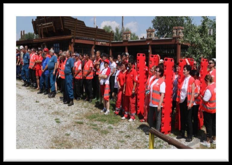
2 Problem: Why was this project necessary? The area of coverage of the problem is the Water Basin of Tisa River with its tributaries, Somes, Crasna and Tur that flow along dams from N-W Romania into N-E Hungary, an area prone to flooding: floods occurred in 19 of the last 45 years, the last being in 2013, and usually affects both counties). Even if working in the same sector, there was a lack of interoperability and of specific methodology of collaboration between the national bodies empowered to coordinate emergency situations and the private (civil) special rescue teams, support NGOs, local volunteer action groups. This lack of procedures and similar knowledge about rescue issues could have led to results like during the 1970 flood that affected this region too, when the intervention teams and even the army were overwhelmed by the situation, which lead to a high number of death. During common activities in emergency situations, frequently appeared misunderstandings between coordinators, specialists and volunteers, leading to delays or errors in the rescue process. The main causes were the lack of similar rescue procedures and techniques and the differences in structure types and way of functioning ( military versus civil ). In Hungary, a closer collaboration between the national bodies and private organizations has begun 4 years ago, starting with common exercises in dam protection. ( In Romania there were no such initiatives, the collaboration between national bodies and rescue teams was practically ad-hoc. Individual development projects were implemented by almost all actors, but none focused on interoperability, none involved all major actors. Somes River Flooding Satu Mare city, P a g e
3 Project objectives and fact sheet Overall objective: The project aimed to improve the preparedness of civil protection professionals and volunteers acting at the Romanian Hungarian border area through strengthened coordinated action and capacity building and through developing a cross-border informational system that enhances its coordinated reaction capacity. Objectives: O1. Developing cross-border civil protection cooperation and interoperability by creating a locally coordinated cross-border group of 7 institutions and organizations that exchanged information and developed common intervention procedures in the context of 2 workshops and 3 roundtables, during 11 months. O2. Supporting capacity building in emergency preparedness for at least 15 institutions and organizations from Hungary and Romania, in the target area (including local volunteer groups) that participated at 5 training sessions and 4 small scale exercises during 11 months of the project implementation. O3. Developing a cross-border informational system by planning and creating a Local Resource Database and Communication System (LoRDaCS) for dynamic adjustment of response capacity in case of disasters. START PROJECT FACT SHEET Project type: ECHO Project website: Coordinating beneficiary: Multisalva Association Satu Mare Implementation countries: Romania and Hungary Project duration: 15 months ( ) Total eligible cost: ,00 EUR EC co-financing: ,00 EUR Contact: Mr. Szabolcs FÜLÖP Multisalva Association Padurea Noroieni Street no. 65, Satu Mare City, Romania Tel: szabolcs@multisalva.ro Facebook: START - Strengthening cross border and inter-sectorial operability Community 3 P a g e
4 Project partners Project coordinator: Asociaţia Multisalva (Multisalva Association) It is a non-profit organization, which provides services in the field of special rescue. Currently the team is composed of 25 volunteers, they are all specialists who have internationally recognized skills and who carry out activities in numerous rescue fields, giving support to governmental organizations during times of natural disasters. Partner 1: Felső-Tiszavidéki Búvár és Mentő Közhasznú Egyesület (Upper Tisa Diving and Rescue Public Utility Association) It was founded by individuals and its members represent different kind of rescue areas. In the beginning its main duty was finding people lost in water, but currently its rescue areas are widened. The rescue techniques of the Association: diving, boating, aeronautical, searching dogs, search and rescue in cities. Partner 2: Inspectoratul pentru Situaţii de Urgenţă Someş judeţul Satu Mare (Someş Inspectorate for Emergency Situations) It is a public authority working at the county level, it is subordinated to the General Inspectorate for Emergency Situations. According legal provisions, ISU Satu Mare provides actions and measures during emergency situations or potential states generating emergency situations. Partner 3: Szabolcs-Szatmár-Bereg Megyei Katasztrófa-védelmi Igazgatóság (Disaster Management Directorate of Sz-Sz-B) It is an organization responsible for the territory of Szabolcs-Szatmár-Bereg County, in the area of fire departments, civilian protection and industry safety. Its main task is to expert authority powers on industrial security, fire protection and civil protection. Partner 4: Societatea Naţională de Cruce Roşie din România, Filiala Satu Mare (Romanian Red Cross Society, Satu Mare) It is an organization with relevant experience in providing relief to the flood affected in targeted area. It has multiple local and regional initiatives, providing social services for disadvantaged groups, working with volunteers and economic agents. Partner 5: Magyar Vöröskereszt Szabolcs-Szatmár-Bereg Megyei Szervezete (Hungarian Red Cross - Sz-Sz-B County) (H) It is an organization with experience in psychological preparedness of general public and volunteer teams. Its main tasks include blood donor recruitment, first aid, social welfare and disaster management; its Tracing Service restores family links broken as a consequence of armed conflicts or natural disasters. Partner 6: Asociaţia Organizaţia Caritas a Diecezei Satu Mare (Caritas Association of the Diocese of Satu Mare) (RO) It is a non-profit organization which is providing social programs and services in the counties of Satu Mare and Maramureş in Northwestern Romania within four areas of activity: socio-educational programs for children and youth, programs for the disabled and the elderly as well as social- charitable programmes. 4 P a g e


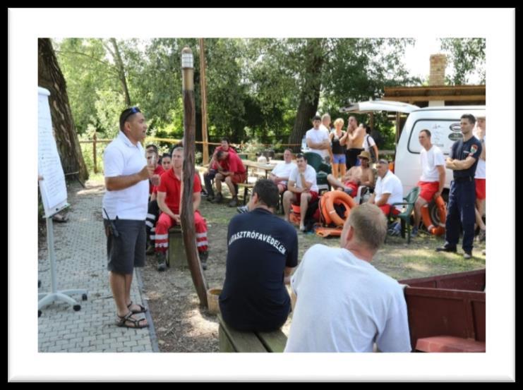
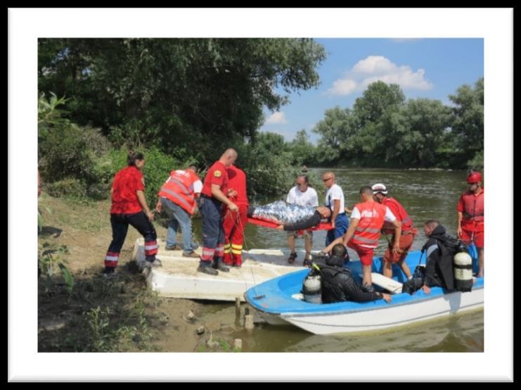
5 Activities used to tackle the problem Establishment of a Cross-Border Crisis Team to coordinate cross-border disaster intervention teams and resources Organizing of roundtables for the team of experts to develop a Common Intervention Plan in case of disasters, assisted and counselled by an international expert from the Netherlands Organizing 3 trainings and 4 small scale exercises for the public and private rescue teams and support organizations Endowment of partners with consumables and equipment Elaboration of a cross-border local resource database for emergency situations Elaboration of an Autonomous Communication System feasibility study Implementation of publicity activities: project opening and closing conferences, press conferences, movies, roll-up banners, leaflets, web page, publication of articles in newspapers and newsletters 5 P a g e

 and NGOs operating in the")


6 Results: Exercises PURPOSE: To simulate a dam failure and flooding / ice rescue / water rescue event in order to discover the strengths and the weaknesses of organizing the rescue and saving activities by the participant teams TARGET GROUPS: Representatives of project partners, state institutions (municipalities, gendarmerie, water directorates, border police, environment protection agencies) and NGOs operating in the field of rescue and support in case of disasters POSITIVE EXPERIENCES: All participants tried to solve cooperative the problems during the exercise. There were positive feedbacks from the observers invited for the exercise and from the local people. The effectiveness of the cooperation between the units became better. The exercise was very spectacular, the press was very positive about it, because the safety of the population has news value. 6 P a g e
 that could be involved in case of necessity FEASIBILITY STUDY To")
7 Impact DATA BASE Updated information source at the Cross-Border Crisis Team disposal regarding available material resources in the cross-border area prone to flooding, that could be used in case of disasters Updated information source at the Cross-Border Crisis Team disposal regarding available human resources (volunteers) that could be involved in case of necessity FEASIBILITY STUDY To evaluate the functionality of a complementary communication system between the partners and the stakeholders, that can be used even when other communication lines are down To study the possibility of a dynamic adjustment of response capacity in case of disasters, coordinated by CBCT through a communication system that connects all stakeholders This document does not necessarily reflect the European Union s opinion 7 P a g e
ACTION PLAN FOR WORLD HERITAGE IN LATIN AMERICA AND THE CARIBBEAN ( )
") Annex ACTION PLAN FOR WORLD HERITAGE IN LATIN AMERICA AND THE CARIBBEAN (2014-2024) The current Regional Action Plan for Latin America and the Caribbean for 2014-2024 has been elaborated by the State Parties
Annex ACTION PLAN FOR WORLD HERITAGE IN LATIN AMERICA AND THE CARIBBEAN (2014-2024) The current Regional Action Plan for Latin America and the Caribbean for 2014-2024 has been elaborated by the State Parties
UNESCO World Heritage Centre - Arab States Unit
 UNESCO World Heritage Centre - Arab States Unit Post-Conflict Reconstruction in the Middle East Context and in the Old City of Aleppo in Particular UNESCO Headquarter, 18-19 June 2015 ACTION PLAN resulting
SEISMIC RISK ASSESSMENT IN ARMENIA
 SEISMIC RISK ASSESSMENT IN ARMENIA Hovhannes Khangeldyan Head of National Crisis Management Center Rescue Service Ministry of Emergency Situations of the Republic of Armenia Tokyo, 2016 ARMENIA: GEOGRAPHICAL
WMO/WWRP FDP: INCA CE
 WMO/WWRP FDP: INCA CE Yong Wang ZAMG, Austria This project is implemented through the CENTRAL EUROPE Programme co-financed by the ERDF INCA CE: implementation over Central Europe A Nowcasting Initiative
ACTION PLAN FOR WORLD HERITAGE IN LATIN AMERICA AND THE CARIBBEAN
 Final version-to send to the ACTION PLAN FOR WORLD HERITAGE IN LATIN AMERICA AND THE CARIBBEAN 2014-2024 The current Regional Action Plan for Latin America and the Caribbean has been elaborated by the
Strengthening the cooperation in the region: Carpathian, Tisa,, Danube and Black Sea areas
 Strengthening the cooperation in the region: Carpathian, Tisa,, Danube and Black Sea areas 14th October 2009 SEE Annual Conference Advancing development through transnational cooperation in South East
Contract title: Technical assistance for multi-annual programming of future cross border cooperation programme in the Romania-Serbia cooperation area
 GOVERNMENT OF ROMANIA SERBIAN GOVERNMENT Contract title: Technical assistance for multi-annual programming of future cross border cooperation programme in the Romania-Serbia cooperation area Reference:
Mitigation planning in Epirus- The case of frost and snowfalls. Thematic seminar Epirus September 2011
 Mitigation planning in Epirus- The case of frost and snowfalls Thematic seminar Epirus September 2011 1 Structure of Mitigation Planning in Greece First Level: General Plan for Civil Protection Ksenokratis
Urban Climate Resilience
 Urban Climate Resilience in Southeast Asia Partnership Project Introduction Planning for climate change is a daunting challenge for governments in the Mekong Region. Limited capacity at the municipal level,
GIS Geographical Information Systems. GIS Management
 GIS Geographical Information Systems GIS Management Difficulties on establishing a GIS Funding GIS Determining Project Standards Data Gathering Map Development Recruiting GIS Professionals Educating Staff
INCA CE: Integrating Nowcasting with crisis management and risk prevention in a transnational framework
 INCA CE: Integrating Nowcasting with crisis management and risk prevention in a transnational framework Yong Wang ZAMG, Austria This project is implemented through the CENTRAL EUROPE Programme co-financed
Non-Governmental Organizations for Spatial Data Infrastructure. Environmental Democracy Case
 Non-Governmental Organizations for Spatial Data Infrastructure Environmental Democracy Case L.Jovičić, S.Vrečar, V.Cetl, K.Ristovski GSDI Small Grant Program Award 2011-2012 Non-Governmental Organisations
Regulations on Administration of Earthquake Predictions
 Regulations on Administration of Earthquake Predictions (Promulgated by Decree No.255 of the State Council of the People s Republic of China on December 17, 1998, and effective as of the date of promulgation)
Integrating Nowcastingwith crisis management and risk prevention in a transnational framework (INCA-CE)
") Integrating Nowcastingwith crisis management and risk prevention in a transnational framework (INCA-CE) Yong Wang ZAMG, Austria This project is implemented through the CENTRAL EUROPE Programme co-financed
Integrating Nowcastingwith crisis management and risk prevention in a transnational framework (INCA-CE) Yong Wang ZAMG, Austria This project is implemented through the CENTRAL EUROPE Programme co-financed
National Adaptation Geo-information System (NAGiS) project in Hungary
 project in Hungary") National Adaptation Geo-information System (NAGiS) project in Hungary Mr. Péter Kajner Hungarian Mining and Geological Survey (MBFSZ) National Adaptation Center Department CGE webinar: Geo-information
National Adaptation Geo-information System (NAGiS) project in Hungary Mr. Péter Kajner Hungarian Mining and Geological Survey (MBFSZ) National Adaptation Center Department CGE webinar: Geo-information
THE SEVILLE STRATEGY ON BIOSPHERE RESERVES
 THE SEVILLE STRATEGY ON BIOSPHERE RESERVES 1 VISION FOR BIOSPHERE RESERVES IN THE 21 ST CENTURY The international Seville Conference on Biosphere Reserves, organised by UNESCO, adopted a two-pronged approach,
PART A Project summary
 PART A Project summary A.1 Project identification Project title Project acronym Name of the lead partner organisation in English Specific objective Demonstrattion AF DAF Partner 1.1. Improving innovation
Floods 2014 a wake up call to natural hazards
 Floods 2014 a wake up call to natural hazards Floods affected 119 municipalities (out of 165) 22% of total population affected by floods More than 30 municipalities sustained extensive damage 57 lives
Economic and Social Council
 United Nations Economic and Social Council Distr.: General 18 July 2016 Original: English Committee of Experts on Global Geospatial Information Management Sixth session New York, 3-5 August 2016 Item 2
Harmonizing spatial databases and services at local and regional level
 Harmonizing spatial databases and services at local and regional level A. Ionita 1, M. Caian 2, V. Vassilev 3, V. Craciunescu 2, I. Nedelcu 4 1 Research Institute for Artificial Intelligence, Bucuresti,
Global Monitoring for Environment and Security (GMES)
") Global Monitoring for Environment and Security (GMES) Satellite Earth Observation for the Emergency Services Dr Nick Veck Presentation to the G-STEP Launch Univ. of Leicester 19 th June 2009 Contents of
Global Monitoring for Environment and Security (GMES) Satellite Earth Observation for the Emergency Services Dr Nick Veck Presentation to the G-STEP Launch Univ. of Leicester 19 th June 2009 Contents of
MEMORANDUM OF UNDERSTANDING FOR THE ESTABLISHMENT OF A CARPATHIAN INTEGRATED BIODIVERSITY INFORMATION SYSTEM
 MEMORUM OF UNDERSTING FOR THE ESTABLISHMENT OF A CARPATHIAN INTEGRATED BIODIVERSITY INFORMATION SYSTEM BETWEEN DAPHNE - INSTITUTE OF APPLIED ECOLOGY (hereinafter referred to DAPHNE) EUROPEAN ACADEMY BOLZANO
COUNCIL OF THE EUROPEAN UNION. Brussels, 2 May /14 CULT 68
 COUNCIL OF THE EUROPEAN UNION Brussels, 2 May 2014 9129/14 CULT 68 NOTE from: General Secretariat of the Council to: Permanent Representatives Committee (Part 1) / Council No. prev. doc.: 8892/14 CULT
Disaster Risk Reduction in Survey for Seismic Protection of MES
 Survey for Seismic Protection Ministry of Emergency Situations of Republic of Armenia Disaster Risk Reduction in Survey for Seismic Protection of MES Syuzanna Kakoyan Leading specialist at the Department
RETA 6422: Mainstreaming Environment for Poverty Reduction Category 2 Subproject
 RETA 6422: Mainstreaming Environment for Poverty Reduction Category 2 Subproject A. Basic Data 1. Subproject Title: Poverty-Environment Mapping to Support Decision Making 2. Country Director: Adrian Ruthenberg
Arctic Spatial Data Infrastructure Enabling Access to Arctic Location-Based Information
 Arctic Spatial Data Infrastructure Enabling Access to Arctic Location-Based Information Arctic SDI Side Event Co-Chairs: Arvo Kokkonen Arctic SDI Board Chair & Director General, National Land Survey of
Table G - 6. Mitigation Actions Identified for Implementation by the City of Kent ( ) (From Wilkin County Master Mitigation Action Chart)
 (From Wilkin County Master Mitigation Action Chart)") Table G - 6. Actions Identified by the () (From Master Action Chart) Multi-Hazard Plan, 2017 Action Comments 5 All-Hazards Local Planning & Regulations Update the Operations Plan on an annual basis. Work
Table G - 6. Actions Identified by the () (From Master Action Chart) Multi-Hazard Plan, 2017 Action Comments 5 All-Hazards Local Planning & Regulations Update the Operations Plan on an annual basis. Work
THE ROLE OF GEOSPATIAL AT THE WORLD BANK
 THE ROLE OF GEOSPATIAL AT THE WORLD BANK INSPIRE Conference Barcelona, Spain September 26, 2016 Kathrine Kelm Senior Land Administration Specialist Global Land and Geospatial Unit The World Bank Group
Use of Climate information in Disaster Risk Management in Zimbabwe
 Use of Climate information in Disaster Risk Management in Zimbabwe WMO Regional Technical Meeting & User/CONOPS Workshop, 28 th October 2015 Lameck Betera Department of Civil Protection Institutional Arrangements
Local EPM Implementation Process in 5 stages
 Local PM Implementation Process in 5 stages 3. Working groups 1. City nvironmental Profile/ Outlook 5. Consolidation & Institutionalisation 4. Strategy & Action plans 2. City Consultation Urban nvironmental
Land Use in the context of sustainable, smart and inclusive growth
 Land Use in the context of sustainable, smart and inclusive growth François Salgé Ministry of sustainable development France facilitator EUROGI vice president AFIGéO board member 1 Introduction e-content+
Concept note. High-Level Seminar: Accelerating Sustainable Energy for All in Landlocked Developing Countries through Innovative Partnerships
 Concept note High-Level Seminar: Accelerating Sustainable Energy for All in Landlocked Developing Countries through Innovative Partnerships Date: 24 and 25 October 2016 Venue: Conference Room C3, Vienna
- facilitate the preparation of landslide inventory and landslide hazard zonation maps for the city, - development of precipitation thresholds,
 Date of Submission 29.03.2012 IPL Project Proposal Form 2012 (MAXIMUM: 3 PAGES IN LENGTH) 1. Project Title: (2 lines maximum)-introducing Community-based Early Warning System for Landslide Hazard Management
Republic of Mozambique
 Republic of Mozambique Second Expert's Symposium on Multi-Hazard Early Warning Systems with focus on the Role of National Meteorological and Hydrological Services 5-7 May 2009, Toulouse France 1. Background
SHARE. Structured Humanitarian Assistance Reporting
 SHARE Structured Humanitarian Assistance Reporting A Summary Description and Requirements for Geo-referenced Data Collection and Mapping to Support Humanitarian Assistance Operations Geographic Information
Overview of Early Warning Systems and the role of National Meteorological and Hydrological Services
 Overview of Early Warning Systems and the role of National Meteorological and Hydrological Services South Africa Second Experts Symposium on Multi-Hazard Early Warning Systems With focus on the Role of
INCA-CE: The Challenge of Severe Weather Warnings. Yong Wang, ZAMG
 INCA-CE: The Challenge of Severe Weather Warnings Yong Wang, ZAMG Severe Weather and Impact The need of civil society and economy Save Life! Save Cost! Reduce Risks and impacts! The Challenge of Severe
Analysis of catastrophic floods affecting Croatia in May 2014 Meteorological and Hydrological Service Zagreb, Croatia
 Analysis of catastrophic floods affecting Croatia in May 2014 Meteorological and Hydrological Service Zagreb, Croatia http://meteo.hr Branka Ivančan-Picek e-mail: picek@cirus.dhz.hr Overview The most affected
L i n k i n g f l o o d i m p a c t f o r e c a s t i n g a n d s a t e l l i t e r a p i d m a p p i n g i n E u r o p e
 L i n k i n g f l o o d i m p a c t f o r e c a s t i n g a n d s a t e l l i t e r a p i d m a p p i n g i n E u r o p e Francesco Dottori, Milan Kalas, Peter Salamon, Annett Wania, Ines Rivero (EC JRC)
Norwegian spatial data infrastructure supporting disaster risk management Norwegian Mapping Authority
 Norwegian spatial data infrastructure supporting disaster risk management Norwegian Mapping Authority Arvid Lillethun, Norwegian Mapping Authority Land and Poverty 2018 Conference, World Bank 19.-23. March
United States Multi-Hazard Early Warning System
 United States Multi-Hazard Early Warning System Saving Lives Through Partnership Lynn Maximuk National Weather Service Director, Central Region Kansas City, Missouri America s s Weather Enterprise: Protecting
INCA-CE achievements and status
 INCA-CE achievements and status Franziska Strauss Yong Wang Alexander Kann Benedikt Bica Ingo Meirold-Mautner INCA Central Europe Integrated nowcasting for the Central European area This project is implemented
By Lillian Ntshwarisang Department of Meteorological Services Phone:
 By Lillian Ntshwarisang Department of Meteorological Services Phone: +267 3612200 Email: lntshwarisang@gov.bw/ lntshwarisang@gmail.com Introduction Mandate of DMS Function of the Department Services to
ICZM and MSP in the Black Sea Region
 ICZM and MSP in the Black Sea Region Drd. Claudia Coman, Environmental engineer AG ICZM Focal Point, Romania Black Sea Commission Black Sea Commission on the Protection of the Black Sea against Pollution
World Meteorological Organization
 World Meteorological Organization Opportunities and Challenges for Development of Weather-based Insurance and Derivatives Markets in Developing Countries By Maryam Golnaraghi, Ph.D. Head of WMO Disaster
about GCC
 about GCC Bldg 234, Flat 11, Al Barakat Street, Hail Al Janaubiyah P.O Box: 94, Postal Code: 123, Al Khaudh, Sultante of Oman Fax : +968 24543188 Mobile :+968 96666445 info@gcc-oman.com www.gcc-oman.com
SPLAN-Natura Towards an integrated spatial planning approach for Natura th January, 2017 Brussels. Commissioned by DG Environment
 SPLAN-Natura 2000 Towards an integrated spatial planning approach for Natura 2000 Commissioned by DG Environment 17 th January, 2017 Brussels V. Simeonova (Ph.D.) Drivers towards integrating Biodiversity
UN-GGIM: Strengthening Geospatial Capability
 Fifth Plenary Meeting of UN-GGIM: Europe Brussels, 6-7 June 2018 UN-GGIM: Strengthening Geospatial Capability Walking the talk to leave no one behind Greg Scott, UN-GGIM Secretariat Environmental Statistics
The Strategy of Regional Development of the Carpathians Carpathian Horizon 2020
 The Strategy of Regional Development of the Carpathians Carpathian Horizon 2020 AssociationCarpathian Euroregion Poland Part 1 Current state of the Carpathian Euroregion Current state of the CE Beginning
Al Ain Cultural Heritage Management Strategy 1/102
 AL AIN CULTURAL HERITAGE MANAGEMENT STRATEGY EXECUTIVE SUMMARY The cultural heritage of Al Ain is rich and varied; it consists of tangible and intangible resources and incorporates archaeological sites,
Role of International Ocean Institute (IOI) to Promote Multi-Level and Multi-Coordination of Capacity Building on
 to Promote Multi-Level and Multi-Coordination of Capacity Building on") Role of International Ocean Institute (IOI) to Promote Multi-Level and Multi-Coordination of Capacity Building on Ocean Governance and Sustainable Development By Cherdsak Virapat Executive Director International
Role of International Ocean Institute (IOI) to Promote Multi-Level and Multi-Coordination of Capacity Building on Ocean Governance and Sustainable Development By Cherdsak Virapat Executive Director International
Asia Pacific Ministerial Conference on Housing and Urban Development (APMCHUD) Meeting of the Working Group on Urban and Rural Planning and Management
 Meeting of the Working Group on Urban and Rural Planning and Management") Asia Pacific Ministerial Conference on Housing and Urban Development (APMCHUD) Meeting of the Working Group on Urban and Rural Planning and Management August 16 17, 2012 New Delhi Recommendations of the
Asia Pacific Ministerial Conference on Housing and Urban Development (APMCHUD) Meeting of the Working Group on Urban and Rural Planning and Management August 16 17, 2012 New Delhi Recommendations of the
CONFERENCE STATEMENT
 Final draft CONFERENCE STATEMENT We, the elected representatives of Canada, Denmark/Greenland, the European Parliament, Finland, Iceland, Norway, Russia, Sweden and the United States of America; In collaboration
UNCTAD Single-year Expert Meeting on Tourism s Contribution to Sustainable Development
 UNCTAD Single-year Expert Meeting on Tourism s Contribution to Sustainable Development Geneva, Palais des Nations, Salle XXVI, 14-15 March 2013 Zoritsa Urosevic Head, Institutional & Corporate Relations,
Final Presentation on Disaster Risk Management in Japan. Through ADRC V. R Programme. Main Findings and Action Plan:
 Final Presentation on Disaster Risk Management in Japan Through ADRC V. R Programme Main Findings and Action Plan: Problem/Hazard and Disaster in Japan Good Practiced on Disaster Risk Management in Japan
International Cooperation on Earthquake Disaster Management to Protect Lives
 Pontificia Universidad Católica de Chile Chile, un país s con múltiples m amenazas International Cooperation on Earthquake Disaster Management to Protect Lives Raúl Alvarez Medel, Pontificia Universidad
WMO. Key Elements of PWS and Effective EWS. Haleh Haleh Kootval Chief, PWS Programme
 WMO Key Elements of PWS and Effective EWS Haleh Haleh Kootval Chief, PWS Programme Workshop Objectives This workshop is all about Service Delivery and becoming excellent at it through: Sharing experiences
WHAT HAPPENS WHEN A TORNADO STRIKES THE COMMUNITY? Carroll County Sheriff s Office Emergency Management
 WHAT HAPPENS WHEN A TORNADO STRIKES THE COMMUNITY? Carroll County Sheriff s Office Emergency Management WHAT IS EMERGENCY MANAGEMENT? Carroll County Sheriff s Office Emergency Management Agency is responsible
Key Steps for Assessing Mission Critical Data for An ebook by Geo-Comm, Inc.
 Key Steps for Assessing Mission Critical Data for 9-1-1 An ebook by Geo-Comm, Inc. If you re reading this, you probably understand transitioning to Next Generation 9-1-1 (NG9-1-1) means your Geographic
Report of the Working Group 2 Data Sharing and Integration for Disaster Management *
 UNITED NATIONS E/CONF.104/6 ECONOMIC AND SOCIAL COUNCIL Twentieth United Nations Regional Cartographic Conference for Asia and the Pacific Jeju, 6-9 October 2015 Item 5 of the provisional agenda Report
Impact of Cyclone Nargis
 Lessons Learnt from Nargis Recovery for the Next Disaster International Recovery Forum (2011) 12, JAN 2011, Kobe, Japan Home for over 100 national races. Profile of Myanmar The 2 nd largest country in
Climate Change & Disaster Risk Reduction in Urban Informal Settlements - Seminar Summary Report
 Norwegian University of Life Sciences Faculty of Social Sciences The Department of International Environment and Development Studies (Noragric) 2015 ISSN: 2464-1537 Courting Catastrophe Project Report
Danube-Kris-Mures-Tisa. Agency PUC. Eszter Csókási Managing Director
 Danube-Kris-Mures-Tisa Euroregional Development Agency PUC. Eszter Csókási Managing Director Established: 21 November 1997 Area: 71.6 thousand km2 Population: 5.4 million Managing body: General assembly
MR. George ALEXAKIS, parallel session 3. "Mediterranean Sea Region. laying the conditions. for sustainable growth and jobs"
 parallel session 3 "Mediterranean Sea Region laying the conditions for sustainable growth and jobs" MR. George ALEXAKIS, elected Regional Councillor of Crete, Greece and representative of Crete in CRPM.
Declaration Population and culture
 Declaration Population and culture The ministers of the parties to the Alpine Convention regard the socio-economic and socio-cultural aspects mentioned in Article 2, Paragraph 2, Item a., as being central
Marine/Maritime Spatial Planning Andrej Abramić
 Marine/Maritime Spatial Planning Andrej Abramić EcoAqua SUMMER SCHOOL: Ecosystem approach to aquaculture 26-29th of October 2015 Research and Technology to enhance excellence in Aquaculture development
The National Spatial Strategy
 Purpose of this Consultation Paper This paper seeks the views of a wide range of bodies, interests and members of the public on the issues which the National Spatial Strategy should address. These views
ANNEXURE 8a-e : GEF STANDARD ANNEXES
 ANNEXURE 8a-e : GEF STANDARD ANNEXES 8a 8b 8c 8d 8e Letters of Endorsement Letters of Co-Finance STAP Review Response to STAP Review and GEF Secretariat Reviews Project Site Map 8a) LETTERS OF ENDORSEMENT
DELHI URBAN RESILIENCE PROJECT
 DELHI URBAN RESILIENCE PROJECT Informed citizen-led action improves resilience of high-risk East Delhi communities Photograph SEEDS/ Siddharth Behl Source: The Indian express http//indianexpress.com/article/cities/delhi/unprepared-for-disaster-ten-of-citys-11-districts-prone-to-fires-building-collapse-looms-in-9/#sthash.vheum8rx.dpuf
MOZAMBIQUE: Institutional Arrangements and Achievements
 UN-International Strategy for Disaster Reduction Global Platform for Disaster Risk Reduction- First Session MOZAMBIQUE: Institutional Arrangements and Achievements on Implementation of Hyogo Framework
INSPIRE Impact in Urban Engineering and Regional Development
 INSPIRE Impact in Urban Engineering and Regional Development Florian Petrescu, Oana Luca, Florian Gaman, Cristina Iacoboaea, Mihaela Aldea, Iuliana Boiu Technical University of Civil Engineering Bucharest
CapacityAssessmentofNational MeteorologicalandHydrological ServicesinSupportof DisasterRiskReduction
 CapacityAssessmentofNational MeteorologicalandHydrological ServicesinSupportof DisasterRiskReduction Analysisofthe2006WMO DisasterRiskReduction Country-levelSurvey Capacity Assessment of National Meteorological
The World Bank Health System Performance Reinforcement Project (P156679)
") Public Disclosure Authorized AFRICA Cameroon Health, Nutrition & Population Global Practice IBRD/IDA Investment Project Financing FY 2016 Seq No: 3 ARCHIVED on 14-Apr-2017 ISR27518 Implementing Agencies:
Public Disclosure Authorized AFRICA Cameroon Health, Nutrition & Population Global Practice IBRD/IDA Investment Project Financing FY 2016 Seq No: 3 ARCHIVED on 14-Apr-2017 ISR27518 Implementing Agencies:
EARLY WARNING SYSTEM AND THE ROLE OF METEOROLOGICAL AND HYDROLOGICAL SERVICE CROATIA
 EARLY WARNING SYSTEM AND THE ROLE OF METEOROLOGICAL AND HYDROLOGICAL SERVICE CROATIA Meteorological and Hydrological Service National Protection and Rescue Directorate B. Ivančan an-picek V. Stajčić Establishment
Plan4all (econtentplus project)
") Plan4all (econtentplus project) Karel CHARVAT 1, Tomáš MILDORF 2 1 Help service remote sensing, Ltd., Černoleská 1600, 256 01 Benešov u Prahy, Czech Republic charvat@bnhelp.cz 2 Department of Mathematics
Plan4all (econtentplus project) Karel CHARVAT 1, Tomáš MILDORF 2 1 Help service remote sensing, Ltd., Černoleská 1600, 256 01 Benešov u Prahy, Czech Republic charvat@bnhelp.cz 2 Department of Mathematics
THE DATA REVOLUTION HAS BEGUN On the front lines with geospatial data and tools
 THE DATA REVOLUTION HAS BEGUN On the front lines with geospatial data and tools Slidedoc of presentation for MEASURE Evaluation End of Project Meeting Washington DC May 22, 2014 John Spencer Geospatial
Implementing the Sustainable Development Goals: The Role of Geospatial Technology and Innovation
 Fifth High Level Forum on UN Global Geospatial Information Management Implementing the Sustainable Development Goals: The Role of Geospatial Technology and Innovation 28-30 November 2017 Sheraton Maria
ADVANTAGES OF GIS-INTEGRATED MARITIME DATA IN THE BLACK SEA REGION FOR MULTIPURPOSE USE
 INTERAGENCY INTERACTION IN CRISIS MANAGEMENT AND DISASTER RESPONSE 2017 ADVANTAGES OF GIS-INTEGRATED MARITIME DATA IN THE BLACK SEA REGION FOR MULTIPURPOSE USE Lyubka Pashova 1, Anna Kortcheva 2, Vasko
INSPIRing Geospatial Framework For Local Administrations
 This project is financed by the European Union and the Republic of Turkey Presented at the FIG Congress 2018, May 6-11, 2018 in Istanbul, Turkey National Programme for Turkey 2010 Instrument for Pre-Accession
73/2011 Coll. ACT PART ONE LABOUR OFFICE OF THE CZECH REPUBLIC
 The ASPI system as amended on 25 August 2015 up to Chapter 86/2015 Coll. and 29/2015 Coll.m.s. 73/2011 Coll. - On the Labour Office of the Czech Republic and amending related acts as last amended, the
SWEDISH SDI DEVELOPMENT & IMPLEMENTATION OF INSPIRE
 SWEDISH SDI DEVELOPMENT & IMPLEMENTATION OF INSPIRE Christina Wasström, Lantmäteriet, 801 82 Gävle, Sweden, christina.wasstrom@lm.se ABSTRACT The Swedish Government and Parliament has given Lantmäteriet
Weather Climate Science to Service Partnership South Africa
 PROJECTS UNDERWAY Title of the Weather Climate Science to Service Partnership South Africa Together, building on an existing strong partnership, South African Weather Service and the Met Office will build
Copernicus Academy. Roles and responsibilities of the Copernicus Academy. user uptake. Focus Data uptake, capacity building and skills development
 Copernicus Academy user uptake Roles and responsibilities of the Copernicus Academy The European Commission has launched two Networks, the Copernicus Relays and the Copernicus Academy, to contribute on
St. Pölten University of Applied Sciences. Strategy St. Pölten University of Applied Sciences. fhstp.ac.at
 St. Pölten University of Applied Sciences Strategy 2021 St. Pölten University of Applied Sciences fhstp.ac.at St. Pölten UAS: My best place Our vision St. Pölten University of Applied Sciences (St. Pölten
Copernicus Overview and Emergency Management Service
 Copernicus Overview and Emergency Management Service Frédéric BASTIDE European Commission Open informal session of the United Nations Inter-Agency Meeting on Outer Space Activities 12 March 2013, Geneva
Inventory of United Nations Resolutions on Cartography Coordination, Geographic Information and SDI 1
 Inventory of United Nations Resolutions on Cartography Coordination, Geographic Information and SDI I. Resolutions on Cartography Coordination and Establishment of United Nations Regional Cartographic
WORLD DAY TO COMBAT DESERTIFICATION 2018 IN MONGOLIA
 WORLD DAY TO COMBAT DESERTIFICATION 2018 IN MONGOLIA This year the WDCD slogan was Land has true value. Invest in it to address the importance of sustainable land use, land degradation prevention and its
Building the Sustainable Network of Settlements on the Caspian Sea Region of Kazakhstan
 Building the Sustainable Network of Settlements on the Caspian Sea Region of Kazakhstan Introduction The Ecological Zoning and Identification of Ecological Capacity of Natural and Socio- Economic Potential
DIPLOMA IN DISASTER MANAGEMENT. (Non-Semester) (With effect from the academic year )
 (With effect from the academic year )") DIPLOMA IN DISASTER MANAGEMENT (Non-Semester) (With effect from the academic year 2013-14) Eligibility for the Course Candidate should have passed the Higher Secondary Examination conducted by the Board
DIPLOMA IN DISASTER MANAGEMENT (Non-Semester) (With effect from the academic year 2013-14) Eligibility for the Course Candidate should have passed the Higher Secondary Examination conducted by the Board
1. 1 What hazard maps have been developed in your country?
 REPUBLIC OF SLOVENIA MINISTRY OF DEFENCE ADMINISTRATION FOR CIVIL PROTECTION AND DISASTER RELIEF Kardeljeva plošcad 21, 1000 Ljubljana telephone: (+386) 1 471 33 22, fax: (+386) 1 431 81 17 ANSWERS TO
GLOBAL GEOPARKS NETWORK
 GLOBAL GEOPARKS NETWORK International Association on Geoparks CELEBRATING EARTH HERITAGE SUSTAINING LOCAL COMMUNITIES REQUEST FOR PROPOSALS Communication & Marketing Strategy FOR UNESCO Global Geoparks
Economic and Social Council
 United Nations Economic and Social Council Distr.: General 2 July 2012 E/C.20/2012/10/Add.1 Original: English Committee of Experts on Global Geospatial Information Management Second session New York, 13-15
RURAL-URBAN PARTNERSHIPS: AN INTEGRATED APPROACH TO ECONOMIC DEVELOPMENT
 RURAL-URBAN PARTNERSHIPS: AN INTEGRATED APPROACH TO ECONOMIC DEVELOPMENT William Tompson Head of the Urban Development Programme OECD Public Governance and Territorial Development Directorate JAHRESTAGUNG
Spatial Optimization of CoCoRAHS Network in Tennessee. Joanne Logan Department of Biosystems Engineering and Soil Science University of Tennessee
 Spatial Optimization of CoCoRAHS Network in Tennessee Joanne Logan Department of Biosystems Engineering and Soil Science University of Tennessee Abstract CoCoRaHS (Community Collaborative Rain, Hail and
COMMERCIALISING WEATHER AND CLIMATE SERVICES:
 COMMERCIALISING WEATHER AND CLIMATE SERVICES: THE CASE OF UGANDA BY MICHAEL S.Z. NKALUBO Commissioner for Meteorology/PR of Uganda with WMO Uganda National Meteorological Authority Presentation Outline
PhD in URBAN PLANNING, DESIGN, AND POLICY - 34th cycle
 PhD in URBAN PLANNING, DESIGN, AND POLICY - 34th cycle Research Field: THE MULTIPLE EFFECTS OF B2C E-COMMERCE GROWTH IN ITALY: RETAIL SYSTEM EVOLUTION AND SPATIAL IMPACT. Monthly net income of PhDscholarship
Chair s Summary Adopted at the Thematic Meeting on Enhancing ICT development and connectivity for the Landlocked Developing Countries
 UN-OHRLLS COMPREHENSIVE TEN-YEAR REVIEW CONFERENCE OF THE ALMATY PROGRAMME OF ACTION Chair s Summary Adopted at the Thematic Meeting on Enhancing ICT development and connectivity for the Landlocked Developing
Presentation by Thangavel Palanivel Senior Strategic Advisor and Chief Economist UNDP Regional Bureau for Asia-Pacific
 Presentation by Thangavel Palanivel Senior Strategic Advisor and Chief Economist UNDP Regional Bureau for Asia-Pacific The High-Level Euro-Asia Regional Meeting on Improving Cooperation on Transit, Trade
Transnational SWOT Analysis
 Transnational SWOT Analysis THETRIS PROJECT WP3.4.1 PP6 - LAMORO Development Agency This project is implemented through the CENTRAL EUROPE Programme co-financed by the ERDF 1 Table of Contents Introduction:
2018/1 The integration of statistical and geospatial information. The Regional Committee of UN-GGIM: Americas:
 The following are the conclusions and recommendations of the Regional Committee of the United Nations on Global Geospatial Information Management for the Americas, during its Fifth Session, Thursday 8