Highs and Lows, Floods and Flows PLANETARY MAPPING
|
|
|
- Mae Hodge
- 5 years ago
- Views:
Transcription
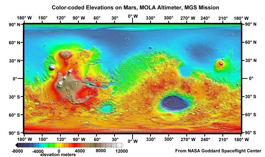
1 Highs and Lows, Floods and Flows PLANETARY MAPPING OVERVIEW Teams of students become familiar with the topography of Mars, its geologic features, and patterns of features using a color-coded topographic map. They discuss the geologic processes that have occurred, or are occurring, and assign relative ages to them. Based on their observations and interests, they propose a landing site for their exploration team. Grades: 5 to 8 Duration: minutes OBJECTIVE Students will: Gain general knowledge about how to read a topographic map Identify elevation features on Mars Identify geologic features and patterns on Mars and relate these to geologic processes Draw conclusions regarding the events and relative ages of geologic features MATERIALS For the class: A large color image of the Mars Orbiter Laser Altimeter (MOLA) map from projected or displayed as a large poster For each team of 2-4 students Investigator Package ACTIVITY Facilitator s Note: The question sets in the Investigator Packet start on a very basic level and become increasingly challenging. If students are already familiar with maps, you may wish to skip question set 1 or review it briefly as a class. 1. Divide the students into groups of planetary scientists. Explain that they are studying the geologic history of a planet. Ultimately they will propose future landing sites for exploration that will help to answer their interesting scientific questions. What scientific questions do they have? Where is the best place on the planet to address these questions? Where would the safest place be to land a rover or an astronaut to address these questions? 2. Invite each team to begin the challenge by projecting or displaying the MOLA map to determine what kind of picture it is and what features might be represented by the different colors. What particular type of picture do you think this is? (a map) What do you think is represented by the different colors? (the answer to this question elevation will be determined by students as they progress through the exercise) 3. Distribute to each group one copy of Investigator Package. Review the Terms to Know and encourage the students to use them throughout the activity. 4. Share your expectations: Give the students directions on which activities to complete and the amount of time you expect them to spend on each section. Have them work together to answer the questions in the package. You may wish to review the answers to each Question Set with the students before proceeding to the next.

2 IN CONCLUSION Ask the teams to share their questions and suggestions for a landing site, and to describe how they think Mars has changed over time. Invite the students to use their observations to justify their explanations, and to describe why they agree or disagree with the different explanations presented. Share that planetary scientists are still formulating models to explain some of the features we observe on Mars and that they do not agree on all of these explanations yet more data is still needed. BACKGROUND INFORMATION Planetary scientists can say a lot about a planet s history by looking at a map of its surface. They examine the features to understand the geologic activity that has occurred, look for patterns, determine the order in which events happened and formulate questions for further exploration. They use maps to select locations on the planet s surface to investigate that may answer those questions. Maps are critical for identifying targets for rovers, human exploration, and future colonies. This activity analyzes the Mars Orbiter Laser Altimeter (MOLA) map, a color-coded topographic map of Mars surface obtained from laser altimeter measurements taken by the Mars Orbiter Laser Altimeter instrument on the Mars Global Surveyor, The format of the MOLA map in this activity is a Mercator projection, a rectangular map with lines of latitude and longitude intersecting at right angles, in which true compass directions are correct but the areas are distorted; features in the extreme north and south are stretched. Mars topography shows a variety of interesting features. The high elevations volcanos are primarily clustered in the Tharsis region near the equator on the left side of the map, probably the result of a hotspot which has caused this bulge in the crust. Just to the right of these volcanos is Mariner Valley (Valles Marineris); this very long straight canyon is a tectonic fault, likely formed when the surface of Mars thinned, stretched, and broke from the volcanic activity. The large very low circular region on the lower right side of the map (Hellas Planitia) is an extremely large impact crater. There are many other impact craters on the map as well.
3 The map also shows features that appear to have been formed by water, north and northeast of Mariner Valley (around the borders of Chryse Panitia). Occasional warm periods in Mars' history resulted in melting of the subsurface ice and gigantic floods. The floods are recorded by outflow channels that feed into the Northern Lowlands, formed from catastrophic floods of water. A quick look at elevations on Mars shows that the northern hemisphere is relatively low or deep and the southern hemisphere is high; this has been called the great dichotomy. The crust in the southern hemisphere is about 25 kilometers (15 miles) thicker than in the northern hemisphere, and this causes the southern highlands to be about 4 kilometers (2.5 miles) higher in elevation than the northern lowlands. This evidently happened in the first few hundred million years of Martian history. The interesting problem is understanding why the crust is thicker in the south than it is in the north. Some scientists suggest that the northern hemisphere low is a depression created either by one giant asteroid impact or by several big impacts. Others suggest that motions inside of the mantle of Mars, known as convection, may have concentrated crust into the southern hemisphere. It is important to note that planetary scientists today are debating this dichotomy. In general, the southern latitudes of Mars are rougher, and the northern latitudes are smoother. Rougher regions on most planets and moons are older regions, with heavier amounts of cratering. Students may need help making this connection. Planetary geologists assume that any location on a planet has an equal chance of being hit by impactors. So they expect a planet to have an even distribution of impact craters. Old surfaces have lots of impact craters, young surfaces have few impact craters. Just like old faces have lots of wrinkles and young faces have few wrinkles. With time, a planet accumulates more and more impacts. When an area has few craters, they suspect that another event has occurred to smooth the surface, such as lava flowing across the surface, or erosion. Imagine a sheet of mud in a rainstorm. Early in the rainstorm, when only a few drops have fallen, there will be only a few raindrop patterns in the mud. With time, as the storm continues, more and more raindrops leave imprints in the mud. The longer (older) a planet s surface is, the more raindrops/impact craters it will have. After the storm, you have a mud sheet peppered with raindrop imprints. Now, imagine taking a bowl of mud and pouring it across half of the sheet. In the area where the new mud was poured, the imprints will be filled in / smoothed over by a newer surface. The mud represents a lava flow filling in and smoothing over the craters. CORRELATION TO STANDARDS Next Generation Science Standards Assessment Standard: 4-ESS2-2. Analyze and interpret data from maps to describe patterns of Earth s features. MS-ESS2-2. Construct an explanation based on evidence for how geoscience processes have changed Earth's surface at varying time and spatial scales. Disciplinary Core Ideas ESS1.C The history of planet Earth: 3-5. Certain features on Earth can be used to order events that have occurred in a landscape. ESS2.B Plate tectonics and large-scale system interactions: 3-5. Earth s physical features occur in patterns, as do earthquakes and volcanoes. Maps can be used to locate features and determine patterns in those events. Science and Engineering Practices Asking Questions and Defining Problems: Ask questions that arise from careful observation of phenomena, models, or unexpected results, to clarify and/or seek additional information. Analyzing and Interpreting Data: Use graphical displays (e.g., maps, charts, graphs, and/or tables) of large data sets to identify temporal and spatial relationships. Analyzing and Interpreting Data: Analyze and interpret data to provide evidence for phenomena.
4 Constructing Explanations and Designing Solutions: Use evidence (e.g., measurements, observations, patterns) to construct or support an explanation or design a solution to a problem. Engaging in Argument from Evidence: Construct and/or support an argument with evidence, data, and/or a model. Engaging in Argument from Evidence: Respectfully provide and receive critiques from peers about a proposed procedure, explanation, or model by citing relevant evidence and posing specific questions. Crosscutting Concepts Patterns: students identify patterns in rates of change and other numerical relationships that provide information about natural and human designed systems. They use patterns to identify cause and effect relationships, and use graphs and charts to identify patterns in data. Structure and Function: students observe the shape and stability of structures of natural and designed objects are related to their function(s). Stability and Change: students learn some systems appear stable, but over long periods of time they will eventually change.
5 ANSWER KEY Question Set 1: Observing Patterns 1. This is a map of which planet? Mars 2a. What do the colors on the map key signify? Elevation 2b. Which physical features are represented by all topographic maps? Size, shape, and elevation are shown on all topographic maps. 3a. Where is north located on this map? Up, or at the top 3b. Where is south located on this map? Down, or at the bottom 4. Where do you think the equator is located? Horizontally across the middle at 0 latitude 5. Where are the red, orange & yellow colors located (in general)? Most of the red, orange, and yellow colors are in the southern hemisphere 6. Where are the greens and blues located (in general)? Most of the greens and blues are in the northern hemisphere 7. Where are the tans and whites? The tans and whites are clustered together 8a. Which colors represent higher terrain? The tans, whites, reds, and oranges are higher terrain 8b. Lower terrains? The greens, blues, and purples represent lower regions. 9. How do you know? You can tell by reading the elevation key on the map you have been given. 10. What patterns do you observe? Answers will vary and may include: Most of the blues and greens are located in the northern hemisphere Most of the reds, oranges and yellows are south of the equator Yellows and greens are found along the length of what looks like a shoreline The rough areas are almost exclusively reds, oranges, and yellows All the white areas are grouped together in close proximity to one another Question Set 2: Analysis & Synthesis 1. What type of map is this? This is a topographic map; it provides elevation information 2. What color are the mountain tops? White 3a. Do any of the colors signify water? No 3b. If not, what does the color blue signify? Lower elevations 4. Refer to the Terms to Know and explain what feature is represented by the darkest blue area. The darkest blue area is a large impact crater basin. 5. What could have caused the darkest blue area to be in a location separate from the large lighter blue areas? That is where an impactor landed, creating a depression even deeper than the naturally occurring lowlands. 6. What indications of past or present flowing water do you observe? Channels from the highlands to the lowlands occur east of the mountains 7. Which areas (colors) of the map look rough? Most of the red, orange, and yellow areas look rough 8a. What makes the area rough? Lots of circular patterns of different sizes. 8b. What do you think caused the roughness? Referring to the Terms to Know, students may conclude that the rough areas are heavily cratered from meteorite impacts.
6 9a. How would you describe the surfaces downslope from the highest peaks (rough or smooth)? Smooth 9b. Do these surfaces have many craters on them? No 10. What might have caused the smoothness; why might this area not be cratered? Answers will vary: Something smoothed it out. It was eroded. There were not as many impacts. Water smoothed it out. Lava flows smoothed it out. Wind smoothed it out. 11a. What kind of geologic features are the highest mountains? Volcanos 11b. Why do you think that? They are the right shape and have lava flows around them. 12. What is the feature just to the east of the mountains that looks like an east-west gash in the surface of the planet? A large fault Questions Set 3: Drawing Conclusions 1. How could smooth surfaces on Mars become rough? From meteorite impacts 2. There is a big difference in the characteristics of the northern part of Mars and the southern part. What could have caused the northern terrain to become smooth? Answers will vary: from flowing water (erosion), being covered up, being filled in by flowing lava, having a big ocean in the north. 3. Which do you think is older, the red rough terrain or the lighter blue smooth terrain? The red rough terrain 4. What are your reasons? The lowest (blue-colored) terrain has fewer craters. Something happened to fill them in. 5. Which do you think is older, the rough red terrain or the smooth red terrain (around the mountains)? The rough red terrain is older. 6. Why do you suspect is it older? The rough red terrain has more craters; the smooth red terrain is younger and has not been hit by as many impactors. The smooth terrain probably is formed by lava flows because they sit next to volcanos. To Mars! Decide as a team what scientific question you have about Mars. Based on your investigations, this could be a geologic question, but it could also be another question that can be answered by the scientific process. To what location will you send a rover or astronaut to gather information that will address your question? Why did you choose this site? Answers will vary.: Wrapping Up Based on your study of the MOLA topographic map of Mars, describe its topographic features and the geologic processes you think may have caused them. Based on your observations, describe how the red planet has changed through time. Answers will vary, but should include some of the following:
7 For topographic features: Volcanos (or volcanic mountains) a much lower, smoother northern hemisphere with few craters higher, rougher southern hemisphere with lots of craters a large depression, or impact basin in the southern area possibly a shoreline separating northern and southern areas smooth areas downslope of the mountains a large fault to the east of the mountainous area channels cutting from the highlands to the lowlands to the east of the volcanos. For geologic processes: Volcanism with large lava flows cratering flowing water carving channels, faulting For evolution of the planet: heavily cratered by impacts craters in low area were filled in or eroded flowing water carved channels between high southern area and low northern area volcanos erupted
8 Investigator Packet Overview: Planetary scientists can say a lot about a planet s history by looking at a map of its surface. They examine the features to understand the geologic activity that has occurred, look for patterns, determine the order in which events happened and formulate questions for further exploration. They use maps to select locations to investigate on that planet s surface that may answer those questions. Maps are critical for identify targets for rovers, human exploration, and future colonies. Your Challenge: As a team, develop a good understanding of the features and geologic history of the planet by answering the questions presented in this Investigator s Packet. At the close of the project, your team will propose a scientific question that could be answered by a rover or astronaut expedition and will identify the best and safest place to go to answer that question. Terms to Know Topographic Map a map that shows natural and human-made features of an area in a way that shows their relative positions and elevations. Topographic maps often show contour lines (lines of equal elevation). Crater large depressions in a planetary surface caused by impactors, such as asteroids or comets. Craters typically are circular in shape and have raised rims. Channel - the bed where a natural stream of water (or lava) runs, or ran. Channels can be straight or sinuous (curvy). Volcano usually a large cone-shaped structure forming at a vent in the surface of a planet through which magma and gases erupt. The cone-shaped feature builds up from the ejected material. Lava molten rock that flows on the surface of a planet (magma is molten rock that is still inside the planet). Early bombardment a period early in the history of the Solar System during which asteroid impacts were very frequent. Very large craters were created on the planets at this time, caused by large impactors. While impacts still occur today, they are less frequent and smaller. Fault a break in a planet s surface, along which blocks of the surface move relative to one another. Faults are long straight features.
9 Question Set 1 - Observing Patterns & Mapping 1. This is a map of which planet? 2a. What do the colors on the map key signify? 2b. Which physical features are represented by all topographic maps? 3a. Where is north located on this map? 3b. Where is south located on this map? 4. Where is the equator is located? 5. Where are red, orange & yellow colors located (in general)? 6. Where are the greens and blues located (in general)? 7. The tans and whites? 8a. Which colors represent higher terrain? 8b. Lower terrain? 9. How do you know? 10. What patterns do you observe? Check your answers with your teacher!
10 Question Set 2 Analysis & Synthesis 1. What type of map is this? 2. What color are the mountain tops? 3a. Do any of the colors signify water? 3b. If not, what does the color blue signify? 4. Refer to the Terms to Know and explain what feature is represented by the darkest blue area. 5. What would have caused the darkest blue area to be in a location separate from the large light blue areas? 6. What indications of past or present flowing water do you observe? Use your writing utensil to mark the possible directions of the flows. 7. Which areas (colors) of the map look rough? 8a. What makes the area rough? 8b. What do you think caused the roughness?
11 9a. How would you describe the surfaces downslope from the highest peaks (rough or smooth)? 9b. Do these surfaces have many craters on them? 10. What might have caused the smoothness; why might this area not be cratered? 11a. What kind of geologic features are the highest mountains? 11b. Why do you think that? 12. What is the feature just to the east of the mountains that looks like an eastwest gash in the surface of the planet? Check your answers with your teacher!
12 Questions Set 3 - Drawing Conclusions 1. How could smooth surfaces on Mars become rough? 2. How could rough surfaces on Mars have been smoothed out? 3. There is a big difference in the character of the northern part of Mars and the southern part. What could have caused the northern terrain to become smooth? 4. Which do you think is older, the red rough terrain or the blue smooth terrain? 5. What are your reasons? 6. Which do you think is older, the rough red terrain or the smooth red terrain (around the mountains)? 7. What are your reasons? Check your answers with your teacher!
13 To Mars! Decide as a team what scientific question you have about Mars. Based on your investigations, this could be a geologic question, but it could also be another question that can be answered by the scientific process. To what location will you send the rover or astronaut to gather information that will address your question? Latitude: Longitude: Why did you choose this site?
14 Wrapping Up The MOLA map you just used to determine your landing site was one of the same maps used by NASA scientists and engineers to determine the landing sites of the rovers, Spirit and Opportunity in the Mars Exploration Rover Mission. Spirit landed in Gusev Crater, located at South and West. Opportunity landed on Meridiani Planum, located at 1.95 South and 5.53 West. Based on your study of the MOLA topographic map of Mars, describe its topographic features and the geologic processes you think may have caused them. Based on your observations, describe how the red planet has changed through time.
15
16 ~ LPI EDUCATION/PUBLIC ENGAGEMENT SCIENCE ACTIVITIES ~
Highs and Lows Floods and Flows
 Highs and Lows Floods and Flows Planetary Mapping Facilitator Guide Becky Nelson Education Specialist The Lunar and Planetary Institute Highs and Lows, Floods and Flows Planetary Mapping Overview In this
Mapping the Surface of Mars Prelab. 1. Explain in your own words what you think a "geologic history" for a planet or moon is?
 Prelab 1. Explain in your own words what you think a "geologic history" for a planet or moon is? 2. Describe some of the major features seen on the Martian surface by various spacecraft missions over the
The Main Points. The View from the Surface. Geology of Mars. Lecture #20: Reading:
 Surface of Mars Lecture #20: Geology and Geologic Processes View from the Surface History/Evolution of the surface Reading: Chapter 9.4 The Main Points Mars has had a geologically active past that has
Ronald Wilhelm & Jennifer Wilhelm, University of Kentucky Ages on Mars. Martian Surface Age Exploration
 Ronald Wilhelm & Jennifer Wilhelm, University of Kentucky 2008 Ages on Mars Martian Surface Age Exploration You have now learned some very important things about various planets and moons in our Solar
Examining the Terrestrial Planets (Chapter 20)
") GEOLOGY 306 Laboratory Instructor: TERRY J. BOROUGHS NAME: Examining the Terrestrial Planets (Chapter 20) For this assignment you will require: a calculator, colored pencils, a metric ruler, and your geology
GEOLOGY 306 Laboratory Instructor: TERRY J. BOROUGHS NAME: Examining the Terrestrial Planets (Chapter 20) For this assignment you will require: a calculator, colored pencils, a metric ruler, and your geology
Chapter 17: Mercury, Venus and Mars
 Chapter 17: Mercury, Venus and Mars Mercury Very similar to Earth s moon in several ways: Small; no atmosphere lowlands flooded by ancient lava flows heavily cratered surfaces Most of our knowledge based
Lecture Outlines. Chapter 10. Astronomy Today 8th Edition Chaisson/McMillan Pearson Education, Inc.
 Lecture Outlines Chapter 10 Astronomy Today 8th Edition Chaisson/McMillan Chapter 10 Mars Units of Chapter 10 10.1 Orbital Properties 10.2 Physical Properties 10.3 Long-Distance Observations of Mars 10.4
Explore Marvel Moon: KID MOON: SPLAT!
 ~ LPI EDUCATION/PUBLIC ENGAGEMENT SCIENCE ACTIVITIES ~ Explore Marvel Moon: KID MOON: SPLAT! OVERVIEW Participants model ancient lunar impacts using water balloons. Like huge asteroids, the water balloons
What are terrestrial planets like on the inside? Chapter 9 Planetary Geology: Earth and the Other Terrestrial Worlds. Seismic Waves.
 Chapter 9 Planetary Geology: Earth and the Other Terrestrial Worlds What are terrestrial planets like on the inside? Seismic Waves Vibrations that travel through Earth s interior tell us what Earth is
Chapter 9 Planetary Geology: Earth and the Other Terrestrial Worlds
 Chapter 9 Planetary Geology: Earth and the Other Terrestrial Worlds 9.1 Connecting Planetary Interiors and Surfaces Our goals for learning What are terrestrial planets like on the inside? What causes geological
Mars ( ) The Sun and Planets Lecture Notes 6. Spring Semester 2018 Prof Dr Ravit Helled
 The Sun and Planets Lecture Notes 6. Spring Semester 2018 Prof Dr Ravit Helled") The Sun and Planets Lecture Notes 6. Spring Semester 2018 Prof Dr Ravit Helled Mars ( ) Mars is the fourth planet from the Sun and the outermost terrestrial planet. It has a density of 3.93 g/cm3, which
The Sun and Planets Lecture Notes 6. Spring Semester 2018 Prof Dr Ravit Helled Mars ( ) Mars is the fourth planet from the Sun and the outermost terrestrial planet. It has a density of 3.93 g/cm3, which
MAPPING THE SURFACE OF MARS
 MAPPING THE SURFACE OF MARS What will you learn in this lab? How can we determine the geologic history of a planet or satellite without travelling to the planetary body? In this lab you will create a simple
ESCI 110: Planetary Surfaces Page 3-1. Exercise 3. Surfaces of the Planets and Moons
 ESCI 110: Planetary Surfaces Page 3-1 Introduction Exercise 3 Surfaces of the Planets and Moons Our knowledge of the solar system has exploded with the space exploration programs of the last 40 years.
COSMORPHOLOGY - May 2009
 Name COSMORPHOLOGY - May 2009 Geologic landforms Purpose: By studying aerial photographs you will learn to identify different kinds of geologic features based on their different morphologies and learn
MARS INSIDE AND OUT.
 GEOLOGIC SCENE INVESTIGATOR JOURNAL MARS INSIDE AND OUT Explore! Mars Inside and Out Investigator Name www.lpi.usra.edu/education PART I: SCRATCHING THE SURFACE GSI: INSIDE MARS COOLING CUPCAKES AND PLANETS
Geologic Features of Mars
 Name Purpose Geologic Features of Mars To learn to identify landforms on the surface of Mars and the geological processes that produced them. Introduction In many ways, Mars is similar to Earth. The same
Introduction. Background
 Introduction In introducing our research on mars we have asked the question: Is there a correlation between the width of an impact crater and the depth of that crater? This will lead to answering the question:
We will apply two of these principles to features on the lunar surface in the following activities.
 STUDENT ACTIVITY 4 Studying the Geologic Past Scientists who study the processes that shape the surface of Earth are called geologists. They have scientific rules, which help them figure out the history
11/4/2015. Venus and Mars. Chapter 13. Venus and Mars. The Rotation of Venus. The Atmosphere of Venus. The Surface of Venus
 Venus and Mars Two most similar planets to Earth: Chapter 13 Venus and Mars Similar in size and mass Same part of the solar system Atmosphere Similar interior structure The Rotation of Venus Almost all
Today. Events. Terrestrial Planet Geology. Fall break next week - no class Tuesday
 Today Terrestrial Planet Geology Events Fall break next week - no class Tuesday When did the planets form? We cannot find the age of a planet, but we can find the ages of the rocks that make it up. We
Chapter 9 Lecture. The Cosmic Perspective Seventh Edition. Planetary Geology: Earth and the Other Terrestrial Worlds Pearson Education, Inc.
 Chapter 9 Lecture The Cosmic Perspective Seventh Edition Planetary Geology: Earth and the Other Terrestrial Worlds Planetary Geology: Earth and the Other Terrestrial Worlds 9.1 Connecting Planetary Interiors
How can solid rock be bent, squished, stretched, and cracked?
 AST 105 Intro Astronomy The Solar System MIDTERM II: Tuesday, April 5 4 Processes that Shape Surfaces Volcanism Eruption of molten rock onto surface Impact cratering Impacts by asteroids or comets Tectonics
Where do they come from?
 Exploring Meteorite Mysteries Lesson 7 Crater Hunters Objectives Students will: observe impact craters on Earth and other solar system bodies. discuss geologic forces that have removed most of the evidence
Mars: The Red Planet. Roman God of war Blood Reflects 30% of its incident sunlight 2 small moons : Phobos and Deimos
 Mars: The Red Planet Roman God of war Blood Reflects 30% of its incident sunlight 2 small moons : Phobos and Deimos Property Earth Mars Radius 6378km 3394km ~ 0.51R E Mass 5.97x10 24 kg 6.42x10 23 kg =
CHANNELS ON MARS. KWL Prior Knowledge/Engagement Activity
 CHANNELS ON MARS KWL Prior Knowledge/Engagement Activity In your small group, brainstorm ideas about what you think you know about channels and what questions you have about channels on Mars. You will
page - Lab 13 - Introduction to the Geology of the Terrestrial Planets
 page - Lab 13 - Introduction to the Geology of the Terrestrial Planets Introduction There are two main families of planets in our solar system: the inner Terrestrial planets (Earth, Mercury, Venus, and
The Moon. Part II: Solar System. The Moon. A. Orbital Motion. The Moon s Orbit. Earth-Moon is a Binary Planet
 Part II: Solar System The Moon Audio update: 2014Feb23 The Moon A. Orbital Stuff B. The Surface C. Composition and Interior D. Formation E. Notes 2 A. Orbital Motion 3 Earth-Moon is a Binary Planet 4 1.
MARINER VENUS / MERCURY 1973 STATUS BULLETIN
 MARINER VENUS / MERCURY 1973 STATUS BULLETIN MARINER 10 PICTURES OF MERCURY; SECOND ENCOUNTER PLANNED Fig. 1. (a) Photomosaic of Mercury made from nine computer-enhanced pictures taken at 234,000 km, 6
Astronomy 1 Fall 2016
 Astronomy 1 Fall 2016 Announcements: 1. Midterm exam on Thursday (in this room) 2. Oct 21 st - 26 th : Sections replaced by evening observing) Lecture 8: October 18, 2016 Previously on Astro 1 Solar System
This evening s announcements
 This evening s announcements Homework 3 is graded and available for pickup at entry Quiz 4 will be held this Wednesday, March 12. Coverage: Feb. 25: origin of the solar system (chapter 6) Feb. 27: Earth,
Erosional Features. What processes shaped this landscape?
 Have you ever looked at the land around you and wondered what processes shaped what you see? Perhaps you see mountains, valleys, rivers, or canyons. Do you know how long these geologic features have been
C E C U R R I C U L U M I E N S C B L E I T A. i N T E G R A T I N G A R T S i n O N A T I D U C B L I P U. Student Learning Objectives:
 Sedimentation E Q U I T A B L E S C I E N C E C U R R I C U L U M Lesson 3 i N T E G R A T I N G A R T S i n P U B L I C E D U C A T I O N NGSS Science Standard: 4-ESS1-1 Identify evidence from patterns
Name Date. Partners. Comparative Planetology by Mary Lou West after Paul Johnson and Ron Canterna
 Name Date Partners Comparative Planetology by Mary Lou West after Paul Johnson and Ron Canterna Purpose : to become familiar with the major features of the planets of the solar system, especially the Earth,
LANDFORMS. Extra Credit. Name Date
 LANDFORMS Extra Credit Name Date 1. Label the drawing above using the words below that match the landforms. canyon meander plateau delta mountain valley 2. The bending of rock at plate boundaries is A.
Overview of Solar System
 Overview of Solar System The solar system is a disk Rotation of sun, orbits of planets all in same direction. Most planets rotate in this same sense. (Venus, Uranus, Pluto are exceptions). Angular momentum
Martian Crater Dating through Isochrons. The universe is a vast and seemingly-endless array of space and matter that
 Gary Studen ASTR 498 5/13/05 Martian Crater Dating through Isochrons Introduction The universe is a vast and seemingly-endless array of space and matter that harbors many mysteries. Through advances in
Welcome to Class 12: Mars Geology & History. Remember: sit only in the first 10 rows of the room
 Welcome to Class 12: Mars Geology & History Remember: sit only in the first 10 rows of the room What are we going to discuss today? How easily could humans live on Mars? Is there water on Mars? PRS: If
Mars. Mars is the fourth planet from the Sun and the outermost of the four terrestrial worlds in the Solar System. It lies outside Earth s orbit.
 Mars Mars is the fourth planet from the Sun and the outermost of the four terrestrial worlds in the Solar System. It lies outside Earth s orbit. Mars s orbital eccentricity is 0.093, much larger than that
EROSIONAL FEATURES. reflect
 reflect Have you ever looked at the land around you and wondered what processes shaped what you see? Perhaps you see mountains, valleys, rivers, or canyons. Do you know how long these geologic features
ESSENTIAL QUESTION How can we use the Mars Map and photographs of Mars to learn about the geologic history of the planet?
 GRADE LEVEL(S) 4 6 LENGTH 60 minutes MATERIALS Giant Destination Mars Map Mars Mapping Student Sheet Colored Markers (red, green, blue) VOCABULARY Crater Erode Ejecta Channel Sun Angle Sequence ESSENTIAL
Geology of the terrestrial planets Pearson Education, Inc.
 Geology of the terrestrial planets 2014 Pearson Education, Inc. Earth s Bulk Properties Earth s Bulk Properties albedo - A = 0.39 A = 0 planet absorbs all sunlight that hits it A =1 planet reflects all
C E C U R R I C U L U M I E N S C B L E I T A. i N T E G R A T I N G A R T S i n O N A T I D U C B L I P U. Student Learning Objectives:
 We athering E Q U I T A B L E S C I E N C E C U R R I C U L U M Lesson 1 i N T E G R A T I N G A R T S i n P U B L I C E D U C A T I O N NGSS Science Standard: 4-ESS1-1 Identify evidence from patterns
Brookhaven Academy. 8 th Grade Earth Science Final Report
 Brookhaven Academy 8 th Grade Earth Science Final Report Introduction and Hypothesis: Science Question: What effect does elevation have on Martian lava flows? Our class was interested in conducting Earth
Unit 3 Lesson 4 The Terrestrial Planets. Copyright Houghton Mifflin Harcourt Publishing Company
 Florida Benchmarks SC.8.N.1.5 Analyze the methods used to develop a scientific explanation as seen in different fields of science. SC.8.E.5.3 Distinguish the hierarchical relationships between planets
SECOND GRADE 1 WEEK LESSON PLANS AND ACTIVITIES
 SECOND GRADE 1 WEEK LESSON PLANS AND ACTIVITIES UNIVERSE CYCLE OVERVIEW OF SECOND GRADE UNIVERSE WEEK 1. PRE: Discovering stars. LAB: Analyzing the geometric pattern of constellations. POST: Exploring
Photogeologic Mapping of Mars
 Exercise Two and Fifteen are suggested as introductory exercises. 2.0 hours Exercise Seventeen Photogeologic Mapping of Mars Instructor Notes Suggested Correlation of Topics Deductive reasoning, geologic
Plates & Boundaries The earth's continents are constantly moving due to the motions of the tectonic plates.
 Plates & Boundaries The earth's continents are constantly moving due to the motions of the tectonic plates. As you can see, some of the plates contain continents and others are mostly under the ocean.
Extraterrestrial Volcanism
 Extraterrestrial Volcanism What does it take to create volcanic activity? How do different planetary conditions influence volcanism? Venus Volcanism in our solar system. Io Europa Mercury Venus Earth/Moon
LUNAR OBSERVING. What will you learn in this lab?
 LUNAR OBSERVING What will you learn in this lab? The Moon is the second most noticeable object in the sky. This lab will first introduce you to observing the Moon with a telescope. You will be looking
Initial Observations and Strategies
 STUDENT WORKSHEET 1 Initial Observations and Strategies Name(s) Date Look at the Thermal Emission Imaging System (THEMIS) Daytime Infrared (IR) image mosaic your teacher has given you. You will be investigating
Moon 101. Bellaire High School Team: Rachel Fisher, Clint Wu, Omkar Joshi
 Moon 101 Bellaire High School Team: Rachel Fisher, Clint Wu, Omkar Joshi Part I Formation of the Moon Planetary Formation In the solar nebula, dust particles coalesced to form smaller planetesimals and
Why Does the Mantle Move the Way it Does?
 Why Does the Mantle Move the Way it Does? In the demonstration, you observed warm water rising through cool water. You also observed cool water sinking to replace the warm water. The movement of a fluid
Outline 9: Origin of the Earth: solids, liquids, and gases. The Early Archean Earth
 Outline 9: Origin of the Earth: solids, liquids, and gases The Early Archean Earth Origin of Earth s Matter The earth is made of recycled elements formed in stars that existed prior to our Sun. Supernova
LESSON 2 THE EARTH-SUN-MOON SYSTEM. Chapter 8 Astronomy
 LESSON 2 THE EARTH-SUN-MOON SYSTEM Chapter 8 Astronomy OBJECTIVES Investigate how the interaction of Earth, the Moon, and the Sun causes lunar phases. Describe conditions that produce lunar and solar eclipses.
UNIVERSITY OF MARYLAND ASTRONOMY DEPARTMENT. Mars Cratering. Crater count isochrons of Arsia and Pavonis Mons
 UNIVERSITY OF MARYLAND ASTRONOMY DEPARTMENT Mars Cratering Crater count isochrons of Arsia and Pavonis Mons Paul Hearding and Ben McIlwain 5/21/2007 Imagery of Arsia and Pavonis Mons taken by Mars Global
Outline 9: Origin of the Earth: solids, liquids, and gases
 Outline 9: Origin of the Earth: solids, liquids, and gases The Early Archean Earth Origin of Earth s Matter The earth is made of recycled elements formed in stars that existed prior to our Sun. Supernova
39 Mars Ice: Intermediate and Distant Past. James W. Head Brown University Providence, RI
 39 Mars Ice: Intermediate and Distant Past James W. Head Brown University Providence, RI james_head@brown.edu 37 Follow the Water on Mars: 1. Introduction: Current Environments and the Traditional View
SOLAR SYSTEM B Division
 SOLAR SYSTEM B Division Team Name: Team #: Student Names: IMAGE SHEET A E B C D F G H Spectrum I Spectrum II SS2014 Spectrum III Spectrum IV Spectrum V Spectrum VI 1. A. What satellite is pictured in Image
2nd Grade Changing of Earth
 Slide 1 / 133 Slide 2 / 133 2nd Grade Changing of Earth 2015-11-23 www.njctl.org Slide 3 / 133 Table of Contents: Changing of Earth Earth and Moon Cycles Weather Cycles The Rock Cycle Defined Events Gradual
2nd Grade. Earth and Moon Cycles. Slide 1 / 133 Slide 2 / 133. Slide 3 / 133. Slide 4 / 133. Slide 5 / 133. Slide 6 / 133.
 Slide 1 / 133 Slide 2 / 133 2nd Grade Changing of Earth 2015-11-23 www.njctl.org Slide 3 / 133 Slide 4 / 133 Table of Contents: Changing of Earth Earth and Moon Cycles Click on the topic to go to that
Interiors of Worlds and Heat loss
 Interiors of Worlds and Heat loss Differentiation -materials separate into layers by gravity How do we learn about planetary interiors? Measure moment of inertia & average density Observe seismic events
Q. Some rays cross maria. What does this imply about the relative age of the rays and the maria?
 Page 184 7.1 The Surface of the Moon Surface Features To the naked eye, the Moon is a world of grays. Some patches are darker than others, creating a vague impression of what some see as a face ( the man
b. What evidence could you see on, above, or around the rim of a planet, dwarf planet, or moon that would indicate the presence of an atmosphere?
 ASTR& 101 Name: Extra Credit Exercise in Planetary Geology: The Geology of Pluto The New Horizons satellite, launched by NASA in 2006, completed its flyby of Pluto in July of 2014, passing the dwarf of
Earth Science 14 th Edition, 2015 Tarbuck Lutgens - Tasa
 A Correlation of Tarbuck Lutgens - Tasa To the Oklahoma Academic Standards for Earth & Space Science A Correlation of, EARTH & SPACE SCIENCE HS-ESS1 Earth s Place in the Universe HS-ESS1-1 Students who
Assignment 4. Due TBD
 Assignment 4 Due TBD Show all work and turn in answers on separate pages, not on these pages. Circle your final answers for clarity. Be sure to show/explain all of your reasoning and that your work is
Are There Plate Tectonics on Mars? 5 th Grade Class of 2013 John Read Middle School Redding, CT 06896
 Are There Plate Tectonics on Mars? 5 th Grade Class of 2013 John Read Middle School Redding, CT 06896 Introduction: Are there plate tectonics on Mars? Could plate tectonics explain the formation of Valles
The Moon & Mercury: Dead Worlds
 The Moon & Mercury: Dead Worlds There are many similarities between the Moon and Mercury, and some major differences we ll concentrate mostly on the Moon. Appearance of the Moon from the Earth We ve already
Introduction to Astronomy
 Introduction to Astronomy AST0111-3 (Astronomía) Semester 2014B Prof. Thomas H. Puzia Venus Venus The atmosphere of Venus is very dense and an opaque layer of clouds covers the planet, such that we cannot
Where we are now. The Moon Chapters 8.2, 9. Topography. Outline
 Where we are now Introduction Little things - comets, asteroids, KBOs Slightly larger things - Moon Larger still - Terrestrial planets Really large - Jovian planets Jovian moons + Pluto Extrasolar Planets
All instruction should be three-dimensional. NGSS Example Bundles. Page 1 of 14
 Middle School Topic Model Course II Bundle 3 Geologic Changes to the Earth This is the third bundle of the Middle School Topics Model Course II. Each bundle has connections to the other bundles in the
8 th Grade Earth Science Brookhaven Academy
 8 th Grade Earth Science Brookhaven Academy Science Question What factors effect lava flows on Mars? Why is this question interesting and important? By studying lava flows on Mars the geology of Mars can
Plate Tectonics. Earth's Crust is broken...but the pieces fit together like a puzzle! And they move- constantly!! What theory explains this process?
 Earth's Crust is broken...but the pieces fit together like a puzzle! And they move- constantly!! What theory explains this process? Were there other theories before this one was determined to be the most
Red Planet Mars. Chapter Thirteen
 Red Planet Mars Chapter Thirteen ASTR 111 003 Fall 2006 Lecture 11 Nov. 13, 2006 Introduction To Modern Astronomy I Introducing Astronomy (chap. 1-6) Planets and Moons (chap. 7-17) Ch7: Comparative Planetology
Camden Fairview NASA Lunar Research Team PowerPoint. October 27, 2011
 Camden Fairview NASA Lunar Research Team PowerPoint October 27, 2011 Introduction to the Moon The Moon is the only natural satellite of the Earth and was formed about the same time, over 4.5 billion years
The Planets. The Terrestrial Planets. Admin. 9/19/17. Key Concepts: Lecture 13. Formulae (will be displayed for you in Midterm 1):
:") Admin. 9/19/17 1. Class website http://www.astro.ufl.edu/~jt/teaching/ast1002/ 2. Optional Discussion sections: Tue. ~11.30am (period 5), Bryant 3; Thur. ~12.35pm (end of period 5 and period 6), start
Admin. 9/19/17 1. Class website http://www.astro.ufl.edu/~jt/teaching/ast1002/ 2. Optional Discussion sections: Tue. ~11.30am (period 5), Bryant 3; Thur. ~12.35pm (end of period 5 and period 6), start
Introduction to Mars PTYS/ASTR 206 3/22/07
 Introduction to Reading Assignment Finish Chapter 13 Announcements Quiz today Will cover all material since the last exam. This is Chapters 9-12 and the part of 13 covered today. Exam #2 next Thursday
deep within the planet. They are also shaped by conditions on the planet s surface. In
 Chapter 4 Landforms, Water, and Natural Resources Earth is home to many different types of landforms. These landforms are shaped by forces deep within the planet. They are also shaped by conditions on
Mercury = Hermes Mythology. Planet Mercury, Element, Mercredi God of Commerce, Messenger God, guide to Hades Winged sandals and staff
 Mercury = Hermes Mythology Planet Mercury, Element, Mercredi God of Commerce, Messenger God, guide to Hades Winged sandals and staff Mercury s Orbit Mercury never seen more than 28 from the sun Revolves/orbits
Question. Which volcano on the Tharsis region of Mars is the youngest?
 Question Which volcano on the Tharsis region of Mars is the youngest? Importance We believe that this question is important and interesting because we don t have any evidence of recent tectonic activity
Earth, the Lively* Planet. * not counting the life on the planet!
 Earth, the Lively* Planet * not counting the life on the planet! What We Will Learn Today What are planet Earth s features? What processes shape planetary surfaces? How does Earth s surface move? How did
Rilles Lunar Rilles are long, narrow, depressions formed by lava flows, resembling channels.
 Rilles Lunar Rilles are long, narrow, depressions formed by lava flows, resembling channels. Rugged Terra Rugged terra are mountainous regions of the moon. Wrinkle Ridges Wrinkle Ridges are created through
I. Introduction: II. Background:
 I. Introduction: Is there a difference between the size of the crater and the ejecta blanket? This question could lead to many different discoveries. When you think about the thousands of craters on mars,
Earth. Physical Properties of Earth kg. Average Density g/cm 2. Surface Gravity 9.8 m/s o C to 50 o C. Surface Temperature
 Earth Physical Properties of Earth Equatorial Diameter Mass 12,756 km 5.976 10 24 kg Average Density 5.497 g/cm 2 Surface Gravity 9.8 m/s 2 Escape Velocity Surface Temperature 11.2 km/s -50 o C to 50 o
9. Moon, Mercury, Venus
 9. Moon, Mercury, Venus All the heavier elements were manufactured by stars later, either by thermonuclear fusion reactions deep in their interiors or by the violent explosions that mark the end of massive
Astro 1010 Planetary Astronomy Sample Questions for Exam 4
 Astro 1010 Planetary Astronomy Sample Questions for Exam 4 Chapter 8 1. Which of the following processes is not important in shaping the surface of terrestrial planets? a) Impact cratering b) Tectonism
Grades 9-12: Earth Sciences
 Grades 9-12: Earth Sciences Earth Sciences...1 Earth s Place in the Universe...1 Dynamic Earth Processes...2 Energy in the Earth System...2 Biogeochemical cycles...4 Structure and Composition of the Atmosphere...4
Grading Summary: Question 1: 80 points. Question 2: 20 points. Total: 100 points
 HOMEWORK #5 Mars & Mercury Due Friday, May 26 th IN CLASS Answers to the questions must be given in complete sentences (except where indicated), using correct grammar and spelling. Please be as brief and
EARTH S SYSTEMS: PROCESSES THAT SHAPE THE EARTH
 9 Week Unit UNIT 2 EARTH S SYSTEMS: PROCESSES THAT SHAPE THE EARTH Fourth Grade Rogers Public Schools : Earth s Systems: Processes that Shape the Earth 9 weeks In this unit, students develop understandings
Back to the Big Question
 5.1 Understand the 5.4 Question Explore Learning Set 5 Back to the Big Question What processes within Earth cause geologic activity? You now know a lot about patterns of volcanoes in your region and around
What You Already Know
 Mars: The Red Planet What You Already Know The Sun is a star, a huge ball of very hot gas that gives off energy. Our Sun is an average star. It is located at the center of the solar system, which consists
Infinity Express. Kendall Planetarium. Planetarium Show Teacher s Guide PROGRAM OUTLINE
 Kendall Planetarium Infinity Express Planetarium Show Teacher s Guide PROGRAM OUTLINE Description: Infinity Express is an immersive experience narrated by Lawrence Fishburne that fully utilizes the unique
1.2: Observing the Surfaces of Mars and Earth
 GEOLOGY ON MARS Unit 1 - Chapter 1-2 Comparing Rocky Planets 1.2: Observing the Surfaces of Mars and Earth Log on to Amplify Geology on Mars Chapter 1.2 In a moment, you will watch a video made by other
What is the Moon? A natural satellite One of more than 96 moons in our Solar System The only moon of the planet Earth
 The Moon What is the Moon? A natural satellite One of more than 96 moons in our Solar System The only moon of the planet Earth Location, location, location! About 384,000 km (240,000 miles) from Earth
Asteroids and comets.
 Asteroids and comets. Question 1 Can Asteroids and comets cause the earth to change? Asteroids do change the earth because when the earth was first starting out Asteroids and comets would come to the earth
Impact Age Dating. ASTRO 202 Lecture Thursday, February 14, Review. What is relative age dating? What is relative age dating?
 Review Impact Age Dating ASTRO 202 Lecture Thursday, February 14, 2008 Carbon-14, Potassium-Argon isotopic age determination: (1) Parent decays to daughter at some predictable rate (2) How much now? (3)
Study Guide: Unit 3. Density and Pressure: You should be able to answer the types of questions given in the end of module questions.
 IDS 102 Study Guide: Unit 3 The purpose of this study guide is to help you prepare for the third exam by focusing your studying and providing example essay questions. In the Focus On section you will find
4 th Grade PSI. Slide 1 / 107 Slide 2 / 107. Slide 3 / 107. Slide 4 / 107. Slide 5 / 107. Slide 6 / 107. The History of Planet Earth
 Slide 1 / 107 Slide 2 / 107 4 th Grade PSI The History of Planet Earth 2015-11-10 www.njctl.org Slide 3 / 107 Slide 4 / 107 The History of Planet Earth The Structure of Earth Rock Layers Fossils and Relative
Assignment 2. Due March 4, 2019
 Assignment 2 Due March 4, 2019 Show all work and turn in answers on separate pages, not on these pages. Circle your final answers for clarity. Be sure to show/explain all of your reasoning and that your
The Moon. Tides. Tides. Mass = 7.4 x 1025 g = MEarth. = 0.27 REarth. (Earth 5.5 g/cm3) Gravity = 1/6 that of Earth
 Gravity = 1/6 that of Earth") The Moon Mass = 7.4 x 1025 g = 0.012 MEarth Radius = 1738 km = 0.27 REarth Density = 3.3 g/cm3 (Earth 5.5 g/cm3) Gravity = 1/6 that of Earth Dark side of the moon We always see the same face of the Moon.
The Moon Mass = 7.4 x 1025 g = 0.012 MEarth Radius = 1738 km = 0.27 REarth Density = 3.3 g/cm3 (Earth 5.5 g/cm3) Gravity = 1/6 that of Earth Dark side of the moon We always see the same face of the Moon.
The Variety of Maps By ReadWorks
 The Variety of Maps By ReadWorks Maps are known for helping us figure out how to get to a certain location: which road do I take to the ice-cream parlor? How do I get from my house to my best friend s?