RCEnE 2018 Manila. Geothermal Energy Development: a Synergy between Science and Engineering
|
|
|
- Charlene Gordon
- 5 years ago
- Views:
Transcription


1 RCEnE 2018 Manila : a Synergy between Science and Engineering Pri Utami Geothermal Research Centre Faculty of Engineering Universitas Gadjah Mada Jalan Grafika 2, Yogyakarta p.utami@ugm.ac.id
2 Talk Coverage HEAT ENERGY BENEATH OUR FEET GEOTHERMAL IN INDONESIA AND PHILIPPINES SCIENCE AND TECHNOLOGY FOR DEVELOPMENT ROOMS FOR SOCIAL ENGINEERING CONCLUDING REMARKS

3 Geothermal: ENERGY BENEATH OUR FEET Virtually infinite energy from the interior of the Earth. More equally distributed than any other source of natural energy.


4 Geothermal energy is contained within a geothermal system, i.e., the system of heat and mass transfer from the inner part of the Earth to the surface. Geothermal systems are open sytem which serve as both natural laboratories and energy sources, which allow us to: Study the Earth and planetary processes. Biodiversity and life in extreme environment. Develop the technology to explore and harness their potential.


5 Extended definition Heat energy from the Earth that can be extracted economically. Challenge for development Resource discovery and characterization Optimation of energy utilization By-product utilization Environmental sustainablity Economic competitiveness Social and cultural acceptability

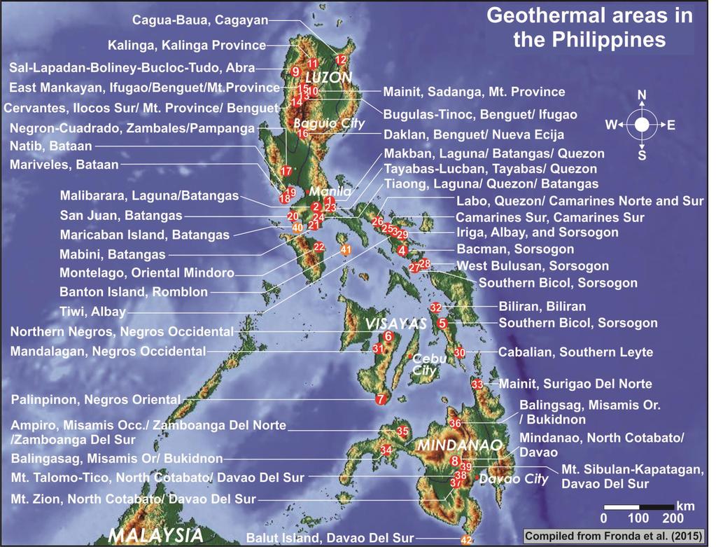
6 Indonesia & Philippines 1 GW Geothermal Country Club

7 342 locations Reserves = 17,506 MW Resources 11,073 MW Utilization 11% of the existing reserves Great opportunity for research & investment National energy security
8

9 Other ASEAN Countries known to have geothermal potential: Malaysia, Vietnam, Thailand
 are now being considered. Low and medium enthalpy systems are being researched.")
10 Resource discovery and characterization INDONESIA MW total potential (onshore) ~ 40% world s resource. Installed capacity : ~1.925 MW: high-temperature, volcano-hosted geothermal fields Hidden systems (lack of manifestations) are now being considered. Low and medium enthalpy systems are being researched. Submarine geothermal has not been considered as an economically and technologically feasible option for development.
11 Keys for succesful development Increase the geological assurance of the resource potential Improve the technology for efficiency of energy extraction and utilization Challenges in research High-temperature, volcano-hosted geothermal system Improve the resolution of geoscientific exploration methods to accurately locate the best production zone. Hidden geothermal system (lack of surface manifestation): Development of exploration technology Technology to access the producible heat at the subsurface. Low & medium enthalpy geothermal system Improvement of the understanding of the geological setting and character of the systems Development of utilization technology
12 Engineering research Geothermal reservoir engineering Accurate measurements or estimation of reservoir properties Development of powerful, user-friendly modelling softwares Fluid production facilities Efficiency of production facilities Material engineering Energy utilization technology Power generation efficiency in conventional plant Binary power plant Direct use Cascade utization By products New paradigm in scaling mitigation

13 High-temperature, volcano-hosted geothermal systems Indonesian archipelago: 80 active and inactive strato-volcanoes 20 volcano-hosted high-temperature geothermal systems MW from 11 fields 7 fields associated with magmatically derived acidic fluids. A. Geothermal systems hosted by young strato-volcanoes: Sibayak (North Sumatra) Kawah Ijen (East Java) and Tangkuban Perahu (West Java) Ulubelu (South Sumatra) B. Geothermal systems associated with acidic fluid feeders: Dieng (Central Java) Lahendong (North Sulawesi) and Patuha (West Java)

14 Challenges in developing potential fields with acidic fluids (Example from Lahendong, North Sulawesi) Corrosion of production facilities in the hottest sector of the field. Environmental management to mitigate possible damage due to the presence of deeply derived corrosive fluids. High NCG content from wells in the central parts of the system: Lower the turbine efficiency. Environmental problem. Anticipation of scaling problem in other parts of the system. Modeling the field hydrology that will help: Build the development strategy to reduce risk of future problems related to deeply-derived acid fluid. Find development target with hightemperature and benign fluids.
15 NZ-type geothermal system in Indonesia? Low relief terrain, high-t, good permeability, benign reservoir fluid Tompaso sector of the Lahendong Tompaso Field, North Sulawesi Detailed, wider coverage of geological survey Detailed, higher resolution of geophysical exploration technology Advanced fluid geochemistry analyzes
 36% old volcanoes")
 Map from Watkinson (2011) Geothermal resource locations from MEMR")
16 Other types of geothermal system Development of suitable exploration concept. Development of direct utilzation design. Example: Sulawesi Occurrence of geothermal resources 6% active volcanoes (Minahasa sector, North Arm) 36% old volcanoes (Gorontalo & South Arm) 28% uplifted granites around the Palu fault zone 30% faulted granite and metamorphic basement rocks and fragments of oceanic crust (Southeast Arm) Map from Watkinson (2011) Geothermal resource locations from MEMR (2004)


17 Offshore geothermal resource development Although in the short term technicaly more difficult and expensive to develop as practical power source, globally the offshore geothermal resource far exceeds the equivalent potential on land. Using mature technology from onshore geothermal and offshore hydrocarbon exploitation, in the future submarine geothermal resources can be an economical affordable option for energy supplies at small to large scale.

18 BANDA Arc continent collision World s deepest through (7 km). World s most tectonically and seismically active region. Limited knowledge on its georesources. Submarine geothermal potential in Banda Sea? Špičák et al (2013) Banda volcanic arc : Alor, Wetar and Romang (active Ma), Damar, Teon, Nila, Serua (currently active), and Manuk (solfataric activity). Ambon volcanic arc : Ambon (active Plateau, Banda Api (currently active). 5 1 Ma, submarine volcanic complex of the Pisang Northwest of the Banda volcanic arc: submarine volcanoes Emperor of China and Nieuwerkerk (active 8 7 Ma), Gunung Api Wetar (currently active), and the submarine Lucipara ridge (active 7 3 Ma).
19 RESEARCH OPPORTUNITIES Submarine geoscience research to characterise the resource Locate the prospects Model the subsurface conditions (size, resevoir rocks, permeability types, temperature and pressure) Understand the fluid quality Fluid-rock interactions, mineralization Heat extraction and utilization technology Material science Suitable materials for the equipments to access and extract the heat energy Other research to ensure the feasibility of the submarine geothermal projects

20 Rooms for Social Engineering Bring geothermal closer to the heart of the society

21 Bring geothermal closer to the heart of the society Geothermal education for the society Introduction to geothermal science and technology to schools Development of geothermal-based economic activities e.g., community-based geothermal tourism, geothermal-powered agro industries, etc.


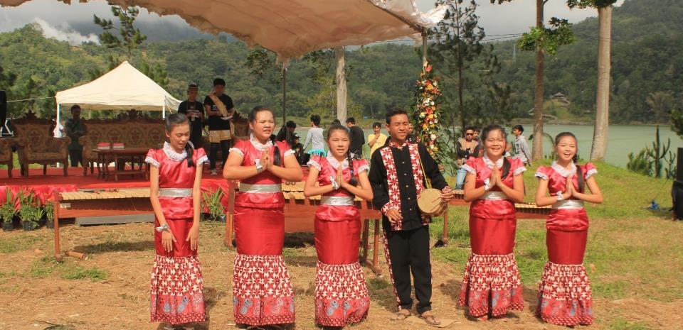
22 The First Indonesian Geothermal Festival Lahendong Geothermal Field, 6 7 August 2015 Soft launching of the lahendong Geothermal Education Park celebrated with the first Indonesian Geothermal Festival.


23 Public activity in the Geothermal Education Park, Lahendong Field, North Sulawesi
 have geothermal energy potential contained in systems different from those of Indonesia and the Philippines, however their potential are worth to be unlocked.")
24 Concluding Remarks Being indigeneous, clean, renewable, and season-independent, geothermal energy is a vital aset for the energy security. Synergy between science and engineering certainly help to explore their potentials, optimize their use, and to increase their economic competitiveness. Other ASEAN Countries (e.g., Malaysia, Thailand, Vietnam) have geothermal energy potential contained in systems different from those of Indonesia and the Philippines, however their potential are worth to be unlocked. Buliding the support from the community to geothermal energy development is equally important to hard-science and engineering research.


25 The 1st Indonesian Geothermal Festival 2015
Overview of Indonesian Geothermal System
 Overview of Indonesian Geothermal System The Resources Beyond High Enthalpy Magmatic/Volcanic Systems By Dr.Eng. Suryantini ITB 4/3/2017 1 Outline Current Condition of Indonesian Geothermal Resources and
Deep-Sea and Sub-Seafloor Resources: A Polymetallic Sulphide and Co-Mn Crust Perspective. Stephen Roberts
 Deep-Sea and Sub-Seafloor Resources: A Polymetallic Sulphide and Co-Mn Crust Perspective by Stephen Roberts The LRET Research Collegium Southampton, 16 July 7 September 2012 1 Deep-Sea and Sub-Seafloor
THE INDONESIA S MINERAL ENERGY POTENTIALS AS THE BASE OF THE REGIONAL ENERGY RESILIENCE 1 By : Mega Fatimah Rosana.
 THE INDONESIA S MINERAL ENERGY POTENTIALS AS THE BASE OF THE REGIONAL ENERGY RESILIENCE 1 By : Mega Fatimah Rosana Senior lecturer at Geology Department, Faculty of Mathematics and Natural Sciences, Padjadjaran
Learning objectives: 1)To describe the principle behind tapping of Geothermal energy 2)To indicate limits and challenges with Geothermal energy usage
To describe the principle behind tapping of Geothermal energy 2)To indicate limits and challenges with Geothermal energy usage") Geothermal Energy Learning objectives: 1)To describe the principle behind tapping of Geothermal energy 2)To indicate limits and challenges with Geothermal energy usage Core: Iron, Nickel, noble metals
Geothermal Energy Learning objectives: 1)To describe the principle behind tapping of Geothermal energy 2)To indicate limits and challenges with Geothermal energy usage Core: Iron, Nickel, noble metals
The Initial-State Geochemistry as a Baseline for Geochemical Monitoring at Ulubelu Geothermal Field, Indonesia
 Proceedings World Geothermal Congress 2015 Melbourne, Australia, 19-25 April 2015 The Initial-State Geochemistry as a Baseline for Geochemical Monitoring at Ulubelu Geothermal Field, Indonesia Mulyanto,
STATUS OF GEOTHERMAL ENERGY PROJECTS IN TANZANIA
 STATUS OF GEOTHERMAL ENERGY PROJECTS IN TANZANIA Regional Geothermal Stakeholders Workshop for East African Rift System Countries and Partners 15-17 March 2010 Nairobi - Kenya Gabriel Mbogoni (Geologist-GST)
GEOTHERMAL ENERGY EXPLORATION IN UGANDA, COUNTRY UPDATE 2006
 GEOTHERMAL ENERGY EXPLORATION IN UGANDA, COUNTRY UPDATE 2006 Godfrey Bahati Department of Geological Survey and Mines, P.O Box 9, Entebbe, Uganda First East African Rift Geothermal Conference-ARGeo ARGeo-C1
GEOLOGICAL HAZARD MITIGATION STRATEGY IN INDONESIA
 GEOLOGICAL HAZARD MITIGATION STRATEGY IN INDONESIA Surono Head of Geological Agency presented in: The 2nd Global Summit of Research Institutes for Disaster Risk Reduction Kihada Hall, Uji Campus, Kyoto
USU 1360 TECTONICS / PROCESSES
 USU 1360 TECTONICS / PROCESSES Observe the world map and each enlargement Pacific Northwest Tibet South America Japan 03.00.a1 South Atlantic Arabian Peninsula Observe features near the Pacific Northwest
CH2356 Energy Engineering Geothermal Energy. Dr. M. Subramanian
 CH2356 Energy Engineering Geothermal Energy Dr. M. Subramanian Associate Professor Department of Chemical Engineering Sri Sivasubramaniya Nadar College of Engineering Kalavakkam 603 110, Kanchipuram(Dist)
Geology Topics. Unit 6 Notes
 Geology Topics Unit 6 Notes Composition of the Earth Earth is layered due to density differences. Crust thin outer layer, solid, made up of continental and oceanic crust Mantle rocky layer below the crust
1.4 Notes: Plates Converge or Scrape Past Each Other Think About Tectonic Plates Push Together at Convergent Boundaries
 1.4 Notes: Plates Converge or Scrape Past Each Other Think About If new crust is created at divergent boundaries, why does the total amount of crust on Earth stay the same? Tectonic Plates Push Together
Opportunities for Geothermal Development Created by New Technologies S2-1-2
 Opportunities for Geothermal Development Created by New Technologies S2-1-2 Geothermal Academy Masami Nakagawa Director of Geothermal Academy Fulbright Energy Specialist CSM/NREL Joint Appointee Department
Keywords: geophysics field camp, low to moderate, temperature, geothermal system, Mt Pancar, Indonesia
 Proceedings World Geothermal Congress 2015 Melbourne, Australia, 19-25 April 2015 Geophysics Field Camp (GFC): A Student Project Aimed to Investigate the Low to Moderate Temperature Geothermal System in
Overview of Microseismic in Sustainable Monitoring of Geothermal Reservoirs in Indonesia*
 Overview of Microseismic in Sustainable Monitoring of Geothermal Reservoirs in Indonesia* Bagus Guspudin 1, Febriwan Mohamad 1, and Hetty Triastuty 2 Search and Discovery Article #80347 (2013) Posted December
The Subsurface Soil Effects Study Using the Short and Long Predominant Periods From H/V Spectrum In Yogyakarta City
 Paper ID 90 The Subsurface Soil Effects Study Using the Short and Long Predominant Periods From H/V Spectrum In Yogyakarta City Z.L. Kyaw 1,2*, S. Pramumijoyo 2, S. Husein 2, T.F. Fathani 3, J. Kiyono
AN OVERVIEW OF RESEARCH AND POTENTIAL IN VIETNAM
 AN OVERVIEW OF RESEARCH AND INVESTIGATION OF GAS HYDRATE POTENTIAL IN VIETNAM Vu Truong Son 1, Do Tu Chung 1, Trinh Nguyen Tinh 1, Nguyen Bieu 2, Tran Van Tri 2, Nguyen Duc Thang 2, Tran Nghi 3 1. Marine
Plates Moving Apart Types of Boundaries
 Plates Moving Apart Types of Boundaries PLATE TECTONICS IS The theory that the Earth s crust is broken into slabs of rock that move around on top of the asthenosphere. How fast are plates moving? The Arctic
Seaport Status, Access, and Regional Development in Indonesia
 Seaport Status, Access, and Regional Development in Indonesia Muhammad Halley Yudhistira Yusuf Sofiyandi Institute for Economic and Social Research (LPEM), Faculty of Economics and Business, University
Plate Tectonics Lab II: Background Information
 Plate Tectonics Lab II: Background Information This lab is based on a UW ESS101 Lab. Note: Hand in only the Answer Sheet at the back of this guide to your Instructor Introduction One of the more fundamental
James Francis Natukunda
 James Francis Natukunda Department of Geological Surveys and Mines Ministry of Energy and Mineral Development, Uganda Regional stakeholders workshop for EARS countries and partners Nairobo, Kenya 15-17
Application of Transient Electromagnetics for the Investigation of a Geothermal Site in Tanzania
 Application of Transient Electromagnetics for the Investigation of a Geothermal Site in Tanzania Gerlinde Schaumann, Federal Institute for Geosciences and Natural Resources (BGR), Stilleweg 2, 30655 Hannover,
Sustainable Energy Science and Engineering Center GEOTHERMAL ENERGY. Sustainable Energy Sources. Source:
 Sustainable Energy Sources GEOTHERMAL ENERGY Earth s Temperature Profile GEOTHERMAL ENERGY Plate Tectonics Earth's crust is broken into huge plates that move apart or push together at about the rate our
Petroleum Exploration
 Petroleum Exploration Upstream Petroleum Exploration The role of exploration is to provide the information required to exploit the best opportunities presented in the choice of areas, and to manage research
Lab 7: Plate tectonics
 Geology 115/History 150 Name(s): Lab 7: Plate tectonics Plate tectonics is the theory that is used to explain geological phenomena worldwide. For this reason, most of the useful maps that illustrate plate
Beneath our Feet: The 4 Layers of the Earty by Kelly Hashway
 Beneath our Feet: The 4 Layers of the Earty by Kelly Hashway The Earth is more than a giant ball made up of dirt, rocks, and minerals. The Earth may look like a giant ball from when looking at it from
PLATE TECTONIC PROCESSES
 Lab 9 Name Sec PLATE TECTONIC PROCESSES 1. Fill in the blank spaces on the chart with the correct answers. Refer to figures 2.3, 2.4 p.33 (2.2 and 2.3 on p. 23) as needed. 2. With your knowledge of different
SWELLING POTENTIAL OF THE RESIDUAL SOIL, BASED ON PLASTICITY INDEX VALUE AT MUAROSIJUNJUNG, WEST SUMATERA
 SWELLING POTENTIAL OF THE RESIDUAL SOIL, BASED ON PLASTICITY INDEX VALUE AT MUAROSIJUNJUNG, WEST SUMATERA Faiq NIRMALA* and Yanwar Yusup RUKMANA Faculty of Geological Engineering, Universitas Padjadjaran,
Imaging Reservoir Structure of Mt. Pancar Geothermal Prospect Using Audio-Frequency Magnetotelluric (AMT) and Gravity Technology
 and Gravity Technology") PROCEEDINGS, 42nd Workshop on Geothermal Reservoir Engineering Stanford University, Stanford, California, February 13-15, 2017 SGP-TR-212 Imaging Reservoir Structure of Mt. Pancar Geothermal Prospect Using
PROCEEDINGS, 42nd Workshop on Geothermal Reservoir Engineering Stanford University, Stanford, California, February 13-15, 2017 SGP-TR-212 Imaging Reservoir Structure of Mt. Pancar Geothermal Prospect Using
Yev Kontar. Illinois State Geological Survey, University of Illinois at Urbana-Champaign
 Addressing Caribbean Geophysical Hazards through the Continuously Operating Caribbean GPS Observational Network (COCONet) and International Ocean Drilling Program (IODP) Yev Kontar Illinois State Geological
Geothermal Development and Research in Chile: the Andean Geothermal Center of Excellence (CEGA)
") ALCUE NET Salta, Argentina 9-12 December 2014 Geothermal Development and Research in Chile: the Andean Geothermal Center of Excellence Dr. Diego Morata Dpto Geología & CEGA Director Fac. Cs Físicas y Matemáticas
ALCUE NET Salta, Argentina 9-12 December 2014 Geothermal Development and Research in Chile: the Andean Geothermal Center of Excellence Dr. Diego Morata Dpto Geología & CEGA Director Fac. Cs Físicas y Matemáticas
MODELING OF MENTAWAI SUBDUCTION ZONE BASED ON GRAVITY DATA
 MODELING OF MENTAWAI SUBDUCTION ZONE BASED ON GRAVITY DATA I. M. Fairayanti 1, Irham, MN 2, H. Danusaputro 3 1,2,3 Department of Physics, Faculty of Science and Mathematics, Diponegoro University, Semarang
PLATE TECTONICS REVIEW GAME!!!!
 PLATE TECTONICS REVIEW GAME!!!! Name the four layers of the earth - crust - mantle - outer core - inner core Which part of Earth s structure contains tectonic plates? LITHOSPHERE Name one reason why the
Earth and Space Science Semester 2 Exam Review. Part 1. - Convection currents circulate in the Asthenosphere located in the Upper Mantle.
 Earth and Space Science 2015 Semester 2 Exam Review Part 1 Convection -A form of heat transfer. - Convection currents circulate in the Asthenosphere located in the Upper Mantle. - Source of heat is from
Forces That Shape Earth. How do continents move? What forces can change rocks? How does plate motion affect the rock cycle?
 Forces That Shape Earth How do continents move? What forces can change rocks? How does plate motion affect the rock cycle? Plate Motion Mountain ranges are produced by plate tectonics. The theory of plate
Theory of Plate Tectonics
 Plate Tectonics Theory of Plate Tectonics Lithosphere is made of sections called plates that move around called continental drift Plates move because they float on the asthenosphere Most plates consist
Map shows 3 main features of ocean floor
 Map shows 3 main features of ocean floor 2017 Pearson Education, Inc. Chapter 3 Marine Provinces 2017 Pearson Education, Inc. 1 Chapter 3 Overview The study of bathymetry determines ocean depths and ocean
Geothermometer, Geoindicator and Isotope Monitoring in Lahendong Wells during
 Proceedings World Geothermal Congress 2015 Melbourne, Australia, 19-25 April 2015 Geothermometer, Geoindicator and Isotope Monitoring in Lahendong Wells during 2010-2012 Azka G., Suryanto S. and Yani A.
Plate Tectonics. entirely rock both and rock
 Plate Tectonics I. Tectonics A. Tectonic Forces are forces generated from within Earth causing rock to become. B. 1. The study of the origin and arrangement of Earth surface including mountain belts, continents,
GEOTHERMAL POTENTIAL OF ST. KITTS AND NEVIS ISLANDS
 GEOTHERMAL POTENTIAL OF ST. KITTS AND NEVIS ISLANDS By Gerald W. Huttrer Geothermal Management Company, Inc. For the Eastern Caribbean Geothermal Energy Project ( Geo- Caraibes ; G-C ) Presented Using
ASSESSMENT OF GEOTHERMAL POTENTIAL AT UNGARAN VOLCANO, INDONESIA DEDUCED FROM NUMERICAL ANALYSIS
 PROCEEDINGS, Thirty-Fourth Workshop on Geothermal Reservoir Engineering Stanford University, Stanford, California, February 9-11, 2009 SGP-TR-187 ASSESSMENT OF GEOTHERMAL POTENTIAL AT UNGARAN VOLCANO,
Tectonic Processes and Hazards Enquiry Question 1: Why are some locations more at risk from tectonic hazards?
 Tectonic Processes and Hazards Enquiry Question 1: Why are some locations more at risk from tectonic hazards? Key words Basalt Andesite Rhyolite Benioff Zone Subduction zone Crustal fracturing Definition
Current tsunami research activities in the Philippines
 DOST PHIVOLCS Current tsunami research activities in the Philippines Graciano P. Yumul, Jr. 1,2, Carla B. Dimalanta 1 and Bart Bautista 3 1 National Institute of Geological Sciences, University of the
UNIVERSITY GADJAH MADA EUBIOS YOUTH LOOKING BEYOND DISASTER (LBD5) FORUM 4-8 SEPTEMBER, Hosted by: Universitas Gadjah Mada
 FORUM 4-8 SEPTEMBER, Hosted by: Universitas Gadjah Mada") UNIVERSITY GADJAH MADA EUBIOS YOUTH LOOKING BEYOND DISASTER (LBD5) FORUM 4-8 SEPTEMBER, 2014 Hosted by: Universitas Gadjah Mada Outline LBD program Brief Information of Universitas Gadjah Mada, Indonesia
UNIVERSITY GADJAH MADA EUBIOS YOUTH LOOKING BEYOND DISASTER (LBD5) FORUM 4-8 SEPTEMBER, 2014 Hosted by: Universitas Gadjah Mada Outline LBD program Brief Information of Universitas Gadjah Mada, Indonesia
AGENDA HIGHT LIGHT OF INDONESIA EXPLORATION ACTIVITY BACKGROUND
 AGENDA Background - Hight Light of Indonesia Exploration Activity - Obstacles - Exploration Opportunity - Exploration Strategy Definition - Exploration Incentives - New Field NELLI EKAYANTI New Field Determining
Earth Science Lesson 3 Dynamic Earth Processes (Grades 8-12 ) Instruction 3-3 Plate Boundaries
 Instruction 3-3 Plate Boundaries") As we told you in a recent Instruction, much of the Earth's lithosphere (its Crust and the top layer of its Outer Mantle) is made up of moving masses of rock called tectonic plates (tectonic means moving).
As we told you in a recent Instruction, much of the Earth's lithosphere (its Crust and the top layer of its Outer Mantle) is made up of moving masses of rock called tectonic plates (tectonic means moving).
Worldwide Power Density Review
 PROCEEDINGS, Thirty-Ninth Workshop on Geothermal Reservoir Engineering Stanford University, Stanford, California, February 24-26, 2014 SGP-TR-202 Worldwide Power Density Review Maxwell Wilmarth 1, James
Heat (& Mass) Transfer. conceptual models of heat transfer. large scale controls on fluid movement. distribution of vapor-saturated conditions
 Transfer. conceptual models of heat transfer. large scale controls on fluid movement. distribution of vapor-saturated conditions") Heat (& Mass) Transfer conceptual models of heat transfer temperature-pressure gradients large scale controls on fluid movement distribution of vapor-saturated conditions fluid flow paths surface manifestations
Heat (& Mass) Transfer conceptual models of heat transfer temperature-pressure gradients large scale controls on fluid movement distribution of vapor-saturated conditions fluid flow paths surface manifestations
Earth s Continents and Seafloors. GEOL100 Physical Geology Ray Rector - Instructor
 Earth s Continents and Seafloors GEOL100 Physical Geology Ray Rector - Instructor OCEAN BASINS and CONTINENTAL PLATFORMS Key Concepts I. Earth s rocky surface covered by of two types of crust Dense, thin,
Initial Borehole Drilling and Testing in Central Huron,
 JULY 2016 PRELIMINARY ASSESSMENT OF POTENTIAL SUITABILITY Initial Borehole Drilling and Testing in Central Huron, Huron-Kinloss and South Bruce DRAFT FOR DISCUSSION WITH COMMUNITIES In 2012, at the request
The Indian Ocean. Copyright 2010 LessonSnips
 The Indian Ocean One of the five major geographic divisions of the world s ocean, the Indian Ocean is located in the Eastern Hemisphere. The Indian Ocean is bounded by three continents: Africa to the west,
Course Syllabus (Contents Part 8) Geothermal Energy
 Geothermal Energy") Course Syllabus (Contents Part 8) PART 8 GEOTHERMAL ENERGY Geothermal energy Typical geothermal gradient Global geothermal resource Plate boundaries & hot spots Major geothermal regions US geothermal resources
Course Syllabus (Contents Part 8) PART 8 GEOTHERMAL ENERGY Geothermal energy Typical geothermal gradient Global geothermal resource Plate boundaries & hot spots Major geothermal regions US geothermal resources
Mineral Deposits of SE Asia: Lessons for Myanmar from Adjacent Regions. Dr Stuart Smith & Prof Khin Zaw
 Mineral Deposits of SE Asia: Lessons for Myanmar from Adjacent Regions Dr Stuart Smith & Prof Khin Zaw 2 Presentation Outline The Big Picture Plate Tectonics Mineral prospectivity is a function of plate
1. In the block diagram shown here, which is the oldest rock unit?
 Pre/Post GCI Name (print) 1. In the block diagram shown here, which is the oldest rock unit? 2. Referring to the same diagram as the previous question, which of the labeled rock units is the youngest?
Geothermal Systems: Geologic Origins of a Vast Energy Resource
 Geothermal Systems: Geologic Origins of a Vast Energy Resource Energy From the Earth Energy-Land-Water Connections Speaker Series James E. Faulds, PhD Nevada State Geologist and Professor Nevada Bureau
GETAHUN Demissie Gemeda P. O. Box 7355, Addis Abeba, Ethiopia Tel. (251) ,
 ,") GETAHUN Demissie Gemeda P. O. Box 7355, Addis Abeba, Ethiopia Tel. (251) 91 173 6725, 92 720 9778 E-mail: getahun.demissie578@gmeil.com, getahun.demissie578@yahoo.com 1. The energy situation in Africa
GETAHUN Demissie Gemeda P. O. Box 7355, Addis Abeba, Ethiopia Tel. (251) 91 173 6725, 92 720 9778 E-mail: getahun.demissie578@gmeil.com, getahun.demissie578@yahoo.com 1. The energy situation in Africa
Plate Tectonics. Structure of the Earth
 Plate Tectonics Structure of the Earth The Earth can be considered as being made up of a series of concentric spheres, each made up of materials that differ in terms of composition and mechanical properties.
OVERVIEW OF GEOTHERMAL RESOURCE EVALUATION OF BANG LE THUY- QUANG BINH
 Proceedings of the 8th Asian Geothermal Symposium, December 9-10, 2008 OVERVIEW OF GEOTHERMAL RESOURCE EVALUATION OF BANG LE THUY- QUANG BINH Nguyen Tien Hung 1. Shigetaka Nakanishi 2, Shigeo Tezuka 3
GIS INTEGRATION METHIOD FOR GEOTHERMAL POWER PLANT SITEING IN SABALAN AREA, NW IRAN
 PROCEEDINGS, Thirty-Third Workshop on Geothermal Reservoir Engineering Stanford University, Stanford, California, January 28-30, 2008 SGP-TR-185 GIS INTEGRATION METHIOD FOR GEOTHERMAL POWER PLANT SITEING
UPDATE OF REGIONAL WEATHER AND SMOKE HAZE (May 2017)
") UPDATE OF REGIONAL WEATHER AND SMOKE HAZE (May 2017) 1. Review of Regional Weather Conditions in April 2017 1.1 Inter monsoon conditions, characterised by afternoon showers and winds that are generally
UPDATE OF REGIONAL WEATHER AND SMOKE HAZE (May 2017) 1. Review of Regional Weather Conditions in April 2017 1.1 Inter monsoon conditions, characterised by afternoon showers and winds that are generally
I 200 anni dell'utilizzo industriale del sito di Larderello: una geotermia sostenibile
 I 200 anni dell'utilizzo industriale del sito di Larderello: una geotermia sostenibile Tipologie di campi geotermici nel mondo e frontiere della ricerca geotermica. Ruggero Bertani Head of geothermal innovation
Shape Earth. Plate Boundaries. Building. Building
 Chapter Introduction Lesson 1 Lesson 2 Lesson 3 Lesson 4 Chapter Wrap-Up Forces That Shape Earth Landforms at Plate Boundaries Mountain Building Continent Building How is Earth s surface shaped by plate
Use models to describe the sun s place in space in relation to the Milky Way Galaxy and the distribution of galaxy clusters in the universe.
 The Milky Way Galaxy consists of more than two hundred billion stars, the sun being one of them, and is one of hundreds of billions of galaxies in the known universe. s of the formation and structure of
UPDATE OF REGIONAL WEATHER AND SMOKE HAZE (February 2018)
") UPDATE OF REGIONAL WEATHER AND SMOKE HAZE (February 2018) 1. Review of Regional Weather Conditions for January 2018 1.1 The prevailing Northeast monsoon conditions over Southeast Asia strengthened in January
UPDATE OF REGIONAL WEATHER AND SMOKE HAZE (February 2018) 1. Review of Regional Weather Conditions for January 2018 1.1 The prevailing Northeast monsoon conditions over Southeast Asia strengthened in January
Earth s Structure and Surface
 Earth s Structure and Surface Structure of the Earth The earth is thought have originated about 4.5 billion years ago from a cloud or clouds of dust. The dust was the remains of a huge cosmic explosion
UPDATE OF REGIONAL WEATHER AND SMOKE HAZE November 2016
 UPDATE OF REGIONAL WEATHER AND SMOKE HAZE November 2016 1. Review of Regional Weather Conditions in November 2016 1.1 Southwest Monsoon conditions prevailed on most days in October 2016 and the winds were
What is the scope for carbon capture and storage in Northern Ireland. Michelle Bentham
 What is the scope for carbon capture and storage in Northern Ireland Michelle Bentham Kingsley Dunham Centre Keyworth Nottingham NG12 5GG Tel 0115 936 3100 What is Carbon Capture and Storage? Capture of
Iwan Yandika Sihotang, Tommy Hendriansyah, Nanang Dwi Ardi
 Proceedings Indonesia International Geothermal Convention & Exhibition 2014 Jakarta Convention Center, Indonesia 4-6 June 2014 FOCAL MECHANISM FOR DETERMINING FAULT PLANES ORIENTATION IN GAMMA GEOTHERMAL
Lab 1: Plate Tectonics April 2, 2009
 Name: Lab 1: Plate Tectonics April 2, 2009 Objective: Students will be introduced to the theory of plate tectonics and different styles of plate margins and interactions. Introduction The planet can be
April 20, 2017 The Dharmawangsa Hotel, Jakarta. Understanding Indonesia s Regional Exploration Potential TOBIAS MAYA PT.
 April 20, 2017 The Dharmawangsa Hotel, Jakarta Understanding Indonesia s Regional Exploration Potential TOBIAS MAYA PT. GEO SEARCH 55Ma 54Ma 53Ma 52Ma 51Ma 50Ma 49Ma 48Ma 47Ma 46Ma 45Ma 44Ma 43Ma 42Ma
Dynamic Earth A B1. Which type of plate boundary is located at the Jordan Fault? (1) divergent (3) convergent (2) subduction (4) transform
 divergent (3) convergent (2) subduction (4) transform") Dynamic Earth A B1 1. The edges of most lithospheric plates are characterized by (1) reversed magnetic orientation (2) unusually rapid radioactive decay (3) frequent volcanic activity (4) low P-wave and
Dynamic Earth A B1 1. The edges of most lithospheric plates are characterized by (1) reversed magnetic orientation (2) unusually rapid radioactive decay (3) frequent volcanic activity (4) low P-wave and
Learning Objectives (LO)! Lecture 11: Plate Tectonics II! No Homework!! ** Chapter 3 **! What we ll learn today:!
! Lecture 11: Plate Tectonics II! No Homework!! ** Chapter 3 **! What we ll learn today:!") Learning Objectives (LO)! Lecture 11: Plate Tectonics II! No Homework!! ** Chapter 3 **! What we ll learn today:! 1. List the three types of tectonic plate boundaries! 2. Describe the processes occurring
Learning Objectives (LO)! Lecture 11: Plate Tectonics II! No Homework!! ** Chapter 3 **! What we ll learn today:! 1. List the three types of tectonic plate boundaries! 2. Describe the processes occurring
Chapter 2 Plate Tectonics and the Ocean Floor
 Chapter 2 Plate Tectonics and the Ocean Floor Matching. Match the term or person with the appropriate phrase. You may use each answer once, more than once or not at all. 1. hydrothermal vents A. convergent
Continental Landscapes
 Continental Landscapes Landscape influenced by tectonics, climate & differential weathering Most landforms developed within the last 2 million years System moves toward an equilibrium Continental Landscapes
Can t t wait to take Exam 4!
 Can t t wait to take Exam 4! Really can t wait to study for the final exam! 1 2 Housekeeping Exam 4: study glossaries, chapter questions TA lab closed after Tues. How to study for exam 4 Make lists for
Bathymetry Measures the vertical distance from the ocean surface to mountains, valleys, plains, and other sea floor features
 1 2 3 4 5 6 7 8 9 10 11 CHAPTER 3 Marine Provinces Chapter Overview The study of bathymetry determines ocean depths and ocean floor topography. Echo sounding and satellites are efficient bathymetric tools.
12. The diagram below shows the collision of an oceanic plate and a continental plate.
 Review 1. Base your answer to the following question on the cross section below, which shows the boundary between two lithospheric plates. Point X is a location in the continental lithosphere. The depth
TSUNAMI AND EARTHQUAKE ACTIVITY IN INDONESIA *
 LOCAL TSUNAMI WARNING AND MITIGATION TSUNAMI AND EARTHQUAKE ACTIVITY IN INDONESIA * Nanang T. Puspito Department of Geophysics and Meteorology, Institute of Technology Bandung (ITB) Address: Jalan Ganeca
FOCAL MECHANISMS OF SUBDUCTION ZONE EARTHQUAKES ALONG THE JAVA TRENCH: PRELIMINARY STUDY FOR THE PSHA FOR YOGYAKARTA REGION, INDONESIA
 FOCAL MECHANISMS OF SUBDUCTION ZONE EARTHQUAKES ALONG THE JAVA TRENCH: PRELIMINARY STUDY FOR THE PSHA FOR YOGYAKARTA REGION, INDONESIA Myo Thant 1, Hiroshi Kawase 2, Subagyo Pramumijoyo 3, Heru Hendrayana
GNS Science Update. New Zealand Geothermal Workshop Dr. Greg Bignall. Department of Geothermal Sciences Wairakei Research Centre
 GNS Science Update New Zealand Geothermal Workshop 2012 Dr. Greg Bignall 1 Department of Geothermal Sciences Wairakei Research Centre Crown Research Institute : New Zealand s leading supplier of earth
Plate Tectonics Tutoiral. Questions. Teacher: Mrs. Zimmerman. Plate Tectonics and Mountains Practice Test
 Teacher: Mrs. Zimmerman Print Close Plate Tectonics and Mountains Practice Test Plate Tectonics Tutoiral URL: http://www.hartrao.ac.za/geodesy/tectonics.html Questions 1. Fossils of organisms that lived
Earthquake Hazards. Tsunami
 Earthquake Hazards Tsunami Measuring Earthquakes Two measurements that describe the power or strength of an earthquake are: Intensity a measure of the degree of earthquake shaking at a given locale based
The Pine Creek AEM Survey, Northern Territory
 The Pine Creek AEM Survey, Northern Territory (Data acquisition, processing, delivery and interpretation) M.A. Craig, M.T. Costelloe, S. Liu, S. Jaireth Onshore Energy and Minerals Division, Geoscience
Earthquake Hazards. Tsunami
 Earthquake Hazards Tsunami Review: What is an earthquake? Earthquake is the vibration (shaking) and/or displacement of the ground produced by the sudden release of energy. The point inside the Earth where
LIGO sees binary neutron star merger on August 17, 2017
 LIGO sees binary neutron star merger on August 17, 2017 Laser Interferometer Gravitational-Wave Observatory (LIGO) Laser Interferometer Gravitational-Wave Observatory (LIGO) Multi-Messenger Astronomy This
Introduction to Subduction Zones
 PAGEOPH, Vol. 128, Nos. 3/4 (1988) 0033~4553/88/040449-0551.50 + 0.20/0 9 1988 Birkh/iuser Verlag, Basel Introduction to Subduction Zones LARRY J. RUFF j and HIROO KANAMORI 2 Subduction zones present many
LECTURE 1 - Introduction Hrvoje Tkalčić
 LECTURE 1 - Introduction Hrvoje Tkalčić *** N.B. The material presented in these lectures is from the principal textbooks, other books on similar subject, the research and lectures of my colleagues from
A) B) C) D) 4. Which diagram below best represents the pattern of magnetic orientation in the seafloor on the west (left) side of the ocean ridge?
 B) C) D) 4. Which diagram below best represents the pattern of magnetic orientation in the seafloor on the west (left) side of the ocean ridge?") 1. Crustal formation, which may cause the widening of an ocean, is most likely occurring at the boundary between the A) African Plate and the Eurasian Plate B) Pacific Plate and the Philippine Plate C)
1. Crustal formation, which may cause the widening of an ocean, is most likely occurring at the boundary between the A) African Plate and the Eurasian Plate B) Pacific Plate and the Philippine Plate C)
The Lithosphere and the Tectonic System. The Structure of the Earth. Temperature 3000º ºC. Mantle
 The Lithosphere and the Tectonic System Objectives: Understand the structure of the planet Earth Review the geologic timescale as a point of reference for the history of the Earth Examine the major relief
Prospects and Status of Exploration for Polymetallic Sulphides. Georgy Cherkashov VNIIOkeangeologia St.Petersburg, RUSSIA
 Prospects and Status of Exploration for Polymetallic Sulphides Georgy Cherkashov VNIIOkeangeologia St.Petersburg, RUSSIA Introduction Outline Hydrothermal processes and seafloor massive sulfides (SMS):
In situ Geothermal Lab Groß Schönebeck
 In situ Geothermal Lab Groß Schönebeck As a member of the Helmholtz Association, the GeoForschungsZentrum (GFZ) is the National Research Centre for Geosciences in Germany Foundation under public law Founded
Cambridge International Examinations Cambridge International General Certificate of Secondary Education
 Cambridge International Examinations Cambridge International General Certificate of Secondary Education *3640589177* ENVIRONMENTAL MANAGEMENT 0680/22 Paper 2 May/June 2016 1 hour 45 minutes Candidates
Outcomes of the Workshop on the Geologic and Geothermal Development of the Western Branch of the Greater East African Rift System
 Outcomes of the Workshop on the Geologic and Geothermal Development of the Western Branch of the Greater East African Rift System Energy Ministerial Meeting 13 June 2016 AUC Headquarter Addis Ababa, Ethiopia
Copyright McGraw-Hill Education. All rights reserved. No reproduction or distribution without the prior written consent of McGraw-Hill Education
 Copyright McGraw-Hill Education. All rights reserved. No reproduction or distribution without the prior written consent of McGraw-Hill Education Tibetan Plateau and Himalaya -southern Asia 11.00.a VE 10X
An overview of petroleum potential and investment opportunities in Southeast Asia
 An overview of petroleum potential and investment opportunities in Southeast Asia Minh Hoang Cu 1*, Khac Hoan Phung 1, Hai An Le 2 1 PVEP Overseas Co., Ltd 2 Hanoi University of Mining and Geology Received
Thursday, April 27, 17
 Thursday, April 27, 17 Geography of Southeast Asia Objec-ve: Understand the geographical differences between the mainland region and the insular region of Southeast Asia. Do Now: What is the capital of
ANOTHER MEXICAN EARTHQUAKE! Magnitude 7.1, Tuesday Sept. 19, 2017
 ANOTHER MEXICAN EARTHQUAKE! Magnitude 7.1, Tuesday Sept. 19, 2017 Why is there no oceanic crust older than 200 million years? SUBDUCTION If new oceanic crust is being continuously created along the earth
The Structure of the Earth and Plate Tectonics
 The Structure of the Earth and Plate Tectonics Structure of the Earth The Earth is made up of 4 main layers: Inner Core Outer Core Mantle Crust Crust Mantle Outer core Inner core The Crust This is where
APPLICATION OF GEOPHYSICS TO GEOTHERMAL ENERGY EXPLORATION AND MONITORING OF ITS EXPLOITATION
 Presented at Short Course III on Exploration for Geothermal Resources, organized by UNU-GTP and KenGen, at Lake Naivasha, Kenya, October 24 - November 17, 2008. GEOTHERMAL TRAINING PROGRAMME Kenya Electricity
Cooperating Country Report of GERMANY
 CCOP-47AS/4.1-19 COORDINATING COMMITTEE FOR GEOSCIENCE PROGRAMMES IN EAST AND SOUTHEAST ASIA (CCOP) 47 th CCOP Annual Session 17-21 October 2010 Manado, Indonesia Cooperating Country Report of GERMANY