LEMBAGA PENERBANGAN DAN ANTARIKSA NASIONAL INDONESIAN NATIONAL INSTITUTE OF AERONAUTICS AND SPACE (LAPAN)
|
|
|
- Heather Gwen Collins
- 5 years ago
- Views:
Transcription
 The Utilization of Remotely Sensed Data to Analyze")

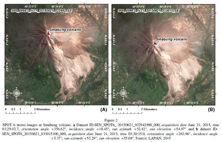
1 LEMBAGA PENERBANGAN DAN ANTARIKSA NASIONAL INDONESIAN NATIONAL INSTITUTE OF AERONAUTICS AND SPACE (LAPAN) The Utilization of Remotely Sensed Data to Analyze The Estimated Volume of Pyroclastic Deposits and Morphological Changes Caused By The Eruption of Sinabung Volcano, North Sumatra, Indonesia Fajar Yulianto

2 Research area at Sinabung volcano in North Sumatra, Indonesia
3 INTRODUCTION (1) Among the developing countries, Indonesia is most vulnerable to natural hazards This vulnerability is caused by the location of the nation at the confluence of three active tectonic plates, namely: Pacific, Euro-Asia, and Indo-Australia The three plates slide past and collide with each other resulting in earthquakes, volcanic eruptions, landslides, floods and tsunami An important control on the occurrence of natural hazards is topography Topography has a dominant influence on the potential and direction of a hazard, such as volcanic eruptions, landslides, and floods
4 INTRODUCTION (2) The availability of topographic data and up-to-date information (including post-hazards topography) is needed to predict and prevent potential hazards in the future and minimize the risk of natural hazards. Limited availability of topographic data during the recent eruptions of Sinabung volcano has been an obstacle in analyzing morphologic change and in obtaining volumes of pyroclastic materials. To address this problem, we extracted a 2015 DEM from SPOT 6 stereo images, which have a spatial resolution of 6 m. By comparing our new DEM with pre eruption topographic maps we are able to estimate the volume of pyroclastic flow deposits and morphological changes for the period
5 METHODOLOGY (1) Data availability For our research we derived a pre-eruption DEM from ASTER GDEM version 1.0 (released 29 June 2009) and SPOT 6 stereo image data, which was acquired on 21 June 2015 Additionally, topographic maps with a scale of 1:50,000 from the Indonesian Geospatial Information Agency (BIG) were used to combine with the ASTER GDEM and used as reference data to evaluate accuracy of the SPOT 6 DEM.
6 METHODOLOGY (2)
7 METHODOLOGY (3) The Estimated Volume of Pyroclastic Deposited As there has been on limited syn-eruption erosion, the approximate volume estimated of pyroclastic flows deposits from eruption of Sinabung volcano during the period 2010 to mid-2015 can be calculated by differencing the pre- and syn-eruption DEM data for this period. Thickness of pyroclastic flows is assumed to be equal to the difference values of elevation in the DEM pre- and syn-eruption data LTF = DEMt2 (syn-eruption) - DEMt1 (pre-eruption data)
8 METHODOLOGY (4) The Estimated Volume of Pyroclastic Deposited The volume of pyroclastic flow deposits can be formulated as shown where VolLF is the volume pyroclastic flow deposited. x and y are the pixel dimensions. m and n are the array of elevation change columns and rows. LTF is the pyroclastic flows thickness for each pixel position (i and j).
9 METHODOLOGY (5) Morphological Change Detection Analysis Morphological change detection analysis can be done by comparing the locations expected to experience change in elevation on the condition pre- and syn- eruption. The analysis is done by creating a cross-section model at several location changes based on the DEM data pre- and syn eruption.

10 (A) ASTER GDEM Year 2009 (B) DEM SPOT 6 Year 2015 RESULTS (1)

11 RESULTS (2) (A) Landsat 8 Year 2015 (B) Thickness of pyroclastic and lava flow deposits year

12 RESULTS (3) Estimated Volume of pyroclastic deposits year = ~ 2.8 x 10^8 m^3 Material Lava = ~ 0.9 x 10^8 m^3 Material Pyroclastics = ~1.9 x 10^8 m^3
")
13 RESULTS (4)
14
15
16 CONCLUSION The purpose of this research is to describe the use of remotely sensed data to estimate the volume of pyroclastic material deposited and to analyze morphological change as a result of the eruption of Sinabung volcano during the period Approximate estimation of 2.8 x 10^8 m^3 for the total volume of eruptive products, comprising 0.9 x 10^8 m^3 of lava flow and dome deposits, and 1.9 x 10^8 m^3 of pyroclastic deposits. Related the Early warning, impact of this eruption volcano not only the primary hazard (Lava and Pyroclastics flow), but also the secondary hazard Lahars (mixed Pyroclastics deposits with rain fall water) can be a threat to the surrounding area. The output of this research can be used as input for modeling secondary hazard.
17 Detail Research Information

18 Remote Sensing Application Center, LAPAN Jl. Kalisari No.8, Pekayon, Pasar Rebo, Jakarta Timur Telp Faks
INTRODUCTION OF A SUCCESS STORY IN THE PHILIPPINES
 INTRODUCTION OF A SUCCESS STORY IN THE PHILIPPINES Arturo S. Daag Department of Science and Technology Philippine Institute of Volcanology and Seismology (DOST-PHIVOLCS) Establishment of Sentinel Asia
Food Security Monitoring Bulletin. INDONESIA Special Focus: Estimating Impact of Disasters on Market Access
 Food Security Monitoring Bulletin INDONESIA Special Focus: Estimating Impact of Disasters on Market Access Volume 10, May 2018 CLIMATE AND FOOD SECURITY January - April 2018 More floods and landslides
Role of Science and Technology in Disaster Preparedness in Indonesia
 2014/SOM3/EPWG/SDMOF/014 Session 1 Role of Science and Technology in Disaster Preparedness in Indonesia Submitted by: Indonesia 8 th Senior Disaster Management Officials Forum Beijing, China 11-12 August
Erupted and killed approximately 15,000 people 200 years ago
 1 2 3 4 5 6 7 8 Introduction to Environmental Geology, 5e Chapter 8 Volcanic Activity Volcanoes: summary in haiku form A volcano forms. Magma comes to the surface - explodes, if felsic. Case History: Mt.
USAGE AND PLANS OF HOTSPOT INFORMATION IN INDONESIA
 USAGE AND PLANS OF HOTSPOT INFORMATION IN INDONESIA Orbita Roswintiarti Natural Resources and Environmental Monitoring Division Indonesian National Institute of Aeronautics and Space (LAPAN) http://www.rs
held on 4 June 2013 Prof. Yoshimori Honkura, Program Officer of Japan Science and Technology Agency (JST) Jakarta, Indonesia Pan Pacific Hotel)
 Jakarta, Indonesia Pan Pacific Hotel)") Overview of the Outcomes from e-asia JRP Disaster Prevention Workshop held on 4 June 2013 Prof. Yoshimori Honkura, Program Officer of Japan Science and Technology Agency (JST) Jakarta, Indonesia (@Sari
Overview of the Outcomes from e-asia JRP Disaster Prevention Workshop held on 4 June 2013 Prof. Yoshimori Honkura, Program Officer of Japan Science and Technology Agency (JST) Jakarta, Indonesia (@Sari
GEOLOGICAL HAZARD MITIGATION STRATEGY IN INDONESIA
 GEOLOGICAL HAZARD MITIGATION STRATEGY IN INDONESIA Surono Head of Geological Agency presented in: The 2nd Global Summit of Research Institutes for Disaster Risk Reduction Kihada Hall, Uji Campus, Kyoto
Weather Satellite Data Applications for Monitoring and Warning Hazard at BMKG
 The 5th Meeting of the Coordinating Group of the RA II WIGOS Satellite Project 21 October 2017, Vladivostok city, Russky Island, Russia Far Eastern Federal University Weather Satellite Data Applications
Jeopardy. Final Jeopardy $100 $100 $100 $100 $100 $200 $200 $200 $200 $200 $300 $300 $300 $300 $400 $400 $400 $500 $500 $500 $500 $500
 Jeopardy Earthquakes Volcanoes Tsunamis Wildfires Landslides/ Droughts $100 $100 $100 $100 $100 $200 $200 $200 $200 $200 $300 $300 $300 $300 $300 $400 $400 $400 $400 $400 $500 $500 $500 $500 $500 Final
Visualizing Earth Science. Chapter Overview. Volcanoes and Eruption Types. By Z. Merali and B. F. Skinner. Chapter 9 Volcanism and Other
 Visualizing Earth Science By Z. Merali and B. F. Skinner Chapter 9 Volcanism and Other Igneous Processes Volcanoes types and effects of eruption Chapter Overview Melting and cooling of rocks Geological
Landslide Susceptibility Mapping Using Logistic Regression in Garut District, West Java, Indonesia
 Landslide Susceptibility Mapping Using Logistic Regression in Garut District, West Java, Indonesia N. Lakmal Deshapriya 1, Udhi Catur Nugroho 2, Sesa Wiguna 3, Manzul Hazarika 1, Lal Samarakoon 1 1 Geoinformatics
New A-Level Physical Geography
 Half Term 1 3.1 Physical Geography: 3.1.5 Hazards: Plate Tectonics This optional section of our specification focuses on the lithosphere and the atmosphere, which intermittently but regularly present natural
2/25/2013. Volcanoes: summary in haiku form A volcano forms. Magma comes to the surface - explodes, if felsic.
 Introduction to Environmental Geology, 5e Edward A. Keller Chapter 8 Volcanic Activity Volcanoes: summary in haiku form A volcano forms. Magma comes to the surface - explodes, if felsic. Lecture Presentation
LOCAL TSUNAMIS: CHALLENGES FOR PREPAREDNESS AND EARLY WARNING
 LOCAL TSUNAMIS: CHALLENGES FOR PREPAREDNESS AND EARLY WARNING HARALD SPAHN 1 1 German Technical Cooperation International Services, Jakarta, Indonesia ABSTRACT: Due to the threat of local tsunamis warning
Australia Government Geospatial Capacity Building Efforts in Asia and the Pacific. Dr John Dawson
 Australia Government Geospatial Capacity Building Efforts in Asia and the Pacific Dr John Dawson Presentation Overview About Geoscience Australia Examples of Geospatial Capacity Building Activity Geodesy
Website Lecture 4 The Physical Environment Continued
 Website http://websites.rcc.edu/halama Lecture 4 The Physical Environment Continued 1 Lecture 4 1. Weather and Climate Global Local 2. Internal Planetary Processes Layers Plate Tectonics Earthquakes Volcanos
GLY July Ms. Nelda Breedt. Plates move slowly and eventually.
 GLY 162 Tectonic Processes: Volcanism Ms. Nelda Breedt GLY 162 Environmental Geology Plate Tectonics Plates move slowly and eventually. 2 Spread apart (divergent plates) Dive beneath one another (converging
CANBERRA SECONDARY SCHOOL Preliminary Examination 2
 CANBERRA SECONDARY SCHOOL 2015 Preliminary Examination 2 Secondary Four (Normal Academic) COMBINED HUMANITIES 11 August 2015 Geography Elective (2194/02) 1 hour 40 minutes 10.30 12.10 Name: ( ) Class:
CAPE Unit 1 Module 2 & 3. Topic Specific Objectives Content Explain the main concepts, flows and processes associated with coastal environments
 # Week(s) Wks 1-3 CAPE Unit 1 Module 2 & 3 Topic Specific Objectives Content Explain the main concepts, flows and processes associated with coastal environments Wave formation, structure, types Textbook
Volcanoes. volcanic hazards. Image courtesy of USGS.
 Volcanoes volcanic hazards Volcanic hazards Pyroclastic flows and surges Pyroclastic flows and surges PYROCLAST: all solid fragments ejected from volcanoes PYROCLASTIC FLOW: A flow of hot gas and volcanic
Tectonic Processes and Hazards Enquiry Question 1: Why are some locations more at risk from tectonic hazards?
 Tectonic Processes and Hazards Enquiry Question 1: Why are some locations more at risk from tectonic hazards? Key words Basalt Andesite Rhyolite Benioff Zone Subduction zone Crustal fracturing Definition
Guidance for GEOGRAPHY End of Year Examination 2016
 Guidance for GEOGRAPHY End of Year Examination 2016 The End of Year Examination takes place in Week 4 of the Summer Term. The Geography Examination will last 50 minutes. The Examination will include questions
Julie Fero NRS 509. Mapping Volcanic Risk with GIS
 Julie Fero NRS 509 Mapping Volcanic Risk with GIS Introduction Volcanoes are present throughout the world, generally occurring along plate margins, making the entire world prone to volcanic influence,
Year 8 Practice Questions for Summative Assessment. NAME:...
 Year 8 Practice Questions for Summative Assessment. NAME:... Earthquakes and Volcanoes 1. (a) The diagram below shows a simple cross section of the Earth. Complete the labels. (b) Name an earthquake you
UGRC 144 Science and Technology in Our Lives/Geohazards
 UGRC 144 Science and Technology in Our Lives/Geohazards Session 6 Volcanic Hazards Lecturer: Dr. Patrick Asamoah Sakyi Department of Earth Science, UG Contact Information: pasakyi@ug.edu.gh College of
EMERGENCY PLANNING IN NORTHERN ALGERIA BASED ON REMOTE SENSING DATA IN RESPECT TO TSUNAMI HAZARD PREPAREDNESS
 EMERGENCY PLANNING IN NORTHERN ALGERIA BASED ON REMOTE SENSING DATA IN RESPECT TO TSUNAMI HAZARD PREPAREDNESS Barbara Theilen-Willige Technical University of Berlin, Institute of Applied Geosciences Department
Volcanic Disaster Mitigation for Living in Harmony with Active Volcanoes
 Volcanic Disaster Mitigation for Living in Harmony with Active Volcanoes SURONO Expert Staf of Ministry of Energy and Mineral Resources, Republic of Indonesia Presented on : The 9 th International Graduate
Change detection at the recently erupted Te Maari crater, Tongariro, from stereo aerial photographs
 Change detection at the recently erupted Te Maari crater, Tongariro, from stereo aerial photographs Strong, D.T., Jones, K.E., Ashraf, S. and Lee, J. Outline Geographic context Setting and eruption Science
Improvement of active volcano monitoring system in east Asia by using SGLI : preparation for realtime high spatial resolution observation
 GCOM WS 2014.1.16 Improvement of active volcano monitoring system in east Asia by using SGLI : preparation for realtime high spatial resolution observation T. Kaneko, A. Yasuda, T. Fujii and K. Kajiwara*
Constructive & Destructive Forces
 Constructive & Destructive Forces Intro: Constructive Forces Processes that create landforms. Destructive Forces Processes that destroy landforms. Intro: Constructive Forces Volcanoes Deposition Landslides
Orting Community College Proposal
 Orting Community College Proposal Cedric, Celina, Francine, Sarah, Samuel GEO CORP Located in Washington, 42 miles south of Seattle. Situated between two rivers on fertile plains. Built on lahar deposits.
The Third UN-GGIM-AP Plenary Meeting. Use of Geospatial Information in Disaster and Coordination among NDMA and Relevant Organizations/Stakeholders
 The Third UN-GGIM-AP Plenary Meeting Use of Geospatial Information in Disaster and Coordination among NDMA and Relevant Organizations/Stakeholders Bali Indonesia 10 November 2014 Bernardus Wisnu Widjaja
Forecasting hotspots in East Kutai, Kutai Kartanegara, and West Kutai as early warning information
 IOP Conference Series: Earth and Environmental Science PAPER OPEN ACCESS Forecasting hotspots in East Kutai, Kutai Kartanegara, and West Kutai as early warning information To cite this article: S Wahyuningsih
Building Disaster Resilience Community in Asia: Indonesian perspective
 Workshop C of the 7th Science Council of Asia (SCA) Conference Construction of Secure and Safe Society against Global Changes of Natural Disasters Okinawa, June 14 th, 2007 Building Disaster Resilience
NGIAs' roles in successful disaster response
 The Second UN-GGIM-AP Plenary Meeting NGIAs' roles in successful disaster response Japan Teheran Iran 28 October 2013 Shin-ichi SAKABE, Director of International Affairs Division Geospatial Information
Copernicus EMS: Αξιολόγηση πολλαπλών φυσικών κινδύνων - Σχεδιασμός και Ανάκτηση
 Building Capacity for a Centre of Excellence for EO-based monitoring of Natural Disasters Copernicus EMS: Αξιολόγηση πολλαπλών φυσικών κινδύνων - Σχεδιασμός και Ανάκτηση Γιάννης Παπουτσής ΙΑΑΔΕΤ Εθνικό
A physical feature of the Earth s surface
 Earth s Landforms A physical feature of the Earth s surface A physical feature of the Earth s surface LANDFORM Highest of Earth s physical features Highest of Earth s physical features MOUNTAIN Low area
Authors. Executive Editors Sutopo Purwo Nugroho Razali Ritonga Rosilawati Anggraini
 Authors Executive Editors Sutopo Purwo Nugroho Razali Ritonga Rosilawati Anggraini Writers Suprapto Theophilus Yanuarto Ratih Nurmasari Ikhsan Prabowo Editors Agus Wibowo Indra Murty Surbakti Ario Akbar
Technical Documentation
 Technical Documentation Tsunami Hazard Maps for Kabupaten Cilacap Multi-sce scenario Tsunami Hazard Map for Kabupaten aten Cilacap, 1:100,000 Multi-scenario Tsunami Hazard Map for the City of Cilacap,,
Chapter: Earthquakes and Volcanoes
 Table of Contents Chapter: Earthquakes and Volcanoes Section 1: Earthquakes Section 2: Volcanoes Section 3: Earthquakes, Volcanoes, and Plate Tectonics 1 Earthquakes What causes earthquakes? Elastic Rebound
Sentinel Asia Tsunami Working Group
 Sentinel Asia Tsunami Working Group Co-Chairman: Prof. Shunichi Koshimura Abdul Muhari, PhD 4 th Joint Project Team Meeting (JPTM 2017): Sentinel Asia STEP 3 Abdul MUHARI, PhD Ministry of Marine Affairs
Major External Processes Driven by energy from the sun and from gravity. Also create hazards and resources.
 Geologic Processes and Hazards Definition of Geology External and Internal Processes: examples of each Fundamentals of Plate Tectonics: definition, types of boundaries, general geography, hazards & resources
José Luis Palma, William Rose and Rüdiger Escobar Wolf Department of Geological Engineering and Sciences Michigan Technological University
 Assessing the Volcanic Threat of Central American Volcanoes José Luis Palma, William Rose and Rüdiger Escobar Wolf Department of Geological Engineering and Sciences Michigan Technological University Outline
NORTH VISTA SECONDARY SCHOOL HUMANITIES DEPARTMENT SECONDARY 3 EXPRESS HUMANITIES (GEOGRAPHY) 2272/02 CONTENT OUTLINE Term 1
 2272/02 CONTENT OUTLINE Term 1") NORTH VISTA SECONDARY SCHOOL HUMANITIES DEPARTMENT SECONDARY 3 EXPRESS HUMANITIES (GEOGRAPHY) 2272/02 CONTENT OUTLINE 2019 Term 1 Week Learning Outcomes Skills to be covered Assignment Test Project 1-2
NORTH VISTA SECONDARY SCHOOL HUMANITIES DEPARTMENT SECONDARY 3 EXPRESS HUMANITIES (GEOGRAPHY) 2272/02 CONTENT OUTLINE 2019 Term 1 Week Learning Outcomes Skills to be covered Assignment Test Project 1-2
THREE DIMENSIONAL DETECTION OF VOLCANIC DEPOSIT ON MOUNT MAYON USING SAR INTERFEROMETRY
 ABSTRACT THREE DIMENSIONAL DETECTION OF VOLCANIC DEPOSIT ON MOUNT MAYON USING SAR INTERFEROMETRY Francis X.J. Canisius, Kiyoshi Honda, Mitsuharu Tokunaga and Shunji Murai Space Technology Application and
Plates Moving Apart Types of Boundaries
 Plates Moving Apart Types of Boundaries PLATE TECTONICS IS The theory that the Earth s crust is broken into slabs of rock that move around on top of the asthenosphere. How fast are plates moving? The Arctic
A New College in Orting?
 A New College in Orting? Risk Report and Recommendation by: Safe Schools Kause Everyone Deserves (SSKED) 2017 Geographic location and physical site of Orting The city of Orting is located in Pierce county,
Progress Report: Sentinel Asia Success Story in the Philippines
 Progress Report: Sentinel Asia Success Story in the Philippines 3 rd Joint Project Team Meeting on the Sentinel Asia STEP-2 July 6-8, 2010 Hyatt Hotel, Manila, Philippines Renato U. Solidum Jr. Director
Earth s Layers p.3 Basic Inner Earth Characteristics
 Earth s Layers p.3 Basic Inner Earth Characteristics Temperature increases with depth Pressure increases with depth Thickest layers to thinnest: mantle, outer core, inner core, crust Earth s Layers p.3
NATIONAL FRAMEWORK FOR FLOOD DISASTER MANAGEMENT IN INDONESIA. 11 th GEOSS ASIA PASIFIC SYMPOSIUM Kyoto, October 2018
 NATIONAL FRAMEWORK FOR FLOOD DISASTER MANAGEMENT IN INDONESIA 11 th GEOSS ASIA PASIFIC SYMPOSIUM Kyoto, 24-26 October 2018 1 OUTLINE Disasters in Indonesia The Disaster Management Mechanism Current Status
Assessment Schedule 2015 Earth and Space Science: Demonstrate understanding of the causes of extreme Earth events in New Zealand (91191)
") NCEA Level 2 Earth and Space Science (91191) 2015 page 1 of 6 Assessment Schedule 2015 Earth and Space Science: Demonstrate understanding of the causes of extreme Earth events in New Zealand (91191) Evidence
NCEA Level 2 Earth and Space Science (91191) 2015 page 1 of 6 Assessment Schedule 2015 Earth and Space Science: Demonstrate understanding of the causes of extreme Earth events in New Zealand (91191) Evidence
Discusssion / Activity 1 Suggested Answers. INSPECTION COPY for schools only
 Earth Structure Discusssion / Activity 1 Suggested Answers 1. Clearly label the diagram to show the main layers of the Earth. 2. What is the lithosphere? The lithosphere is the crust, plus a thin part
8 th Grade Science Plate Tectonics and Topography Review
 8 th Grade Science Plate Tectonics and Topography Review #1 Scientists believe that the land masses of Earth were once joined together as one supercontinent called. A: Australia B: Wegner C: Pangaea D:
Earthquakes & Volcanoes
 Earthquakes & Volcanoes Geology - the study of solid Earth, the rocks of which it is composed, and the processes by which they change geo = Earth; ology = study of Earth s Layers Plate Tectonics - the
Chapter 4. The Earth s Surface: Shaping the crust
 Chapter 4 The Earth s Surface: Shaping the crust Learning outcomes In this chapter you will learn: That the earth is made up of layers Why the earth is shaped as it is What plates are and how they move
Capacity Building in Applications of Remote Sensing and GIS for Disaster Management
 Capacity Building in Applications of Remote Sensing and GIS for Disaster Management M.K. Hazarika, L. Samarakoon, N. Senevirathne, J.S.M. Fowze and R. de Silva Project Researcher GeoInformatics Center
GLG Ch 6: Volcanoes & Volcanic Hazards. 3. Name, describe (DSC) and draw the three types of volcanoes from smallest to largest.
 and draw the three types of volcanoes from smallest to largest.") GLG 101 - Ch 6: Volcanoes & Volcanic Hazards Name 6.1 What Is and and Is Not a Volcano? 1. Three common characteristics of a volcano include A B C 2. How did the Hopi Buttes (figure 06 01.b1) form? 3.
GLG 101 - Ch 6: Volcanoes & Volcanic Hazards Name 6.1 What Is and and Is Not a Volcano? 1. Three common characteristics of a volcano include A B C 2. How did the Hopi Buttes (figure 06 01.b1) form? 3.
GEOLOGY MEDIA SUITE Chapter 12
 UNDERSTANDING EARTH, SIXTH EDITION GROTZINGER JORDAN GEOLOGY MEDIA SUITE Chapter 12 Volcanoes 2010 W.H. Freeman and Company Plate tectonics explains the global pattern of volcanism. Key Figure 12.20 (page
Coastal Abrasion and Accretion Studies of West Sumatera Province in Period
 Journal of Environmental Science and Engineering A 7 (2018) 22-29 doi:10.17265/2162-5298/2018.01.003 D DAVID PUBLISHING Coastal Abrasion and Accretion Studies of West Sumatera Province in Period 2003-2016
GEOLOGY. What is geology?
 GEOLOGY What is geology? It is essentially the study of the earth and it s dynamic processes. Features and processes of rocks, the earth s interior and surface. Structure of the Earth Made up of three
LECTURE #11: Volcanoes: Monitoring & Mitigation
 GEOL 0820 Ramsey Natural Disasters Spring, 2018 LECTURE #11: Volcanoes: Monitoring & Mitigation Date: 15 February 2018 I. What is volcanic monitoring? the continuous collection of one or more data sources
Policies and practices of remote sensing implementation in Indonesia
 Policies and practices of remote sensing implementation in Indonesia AGF 2014 Jakarta, 26 Nov 2014 Orbita Roswintiarti Deputy Chairman for Remote Sensing Affairs Outline Background Role of LAPAN in remote
Predicting the probability of Mount Merapi eruption using Bayesian Event Tree_Eruption Forecasting
 Predicting the probability of Mount Merapi eruption using Bayesian Event Tree_Eruption Forecasting Dyah Ika Rinawati *, Diana Puspita Sari, Naniek Utami Handayani, and Bramasta Raga Siwi Industrial Engineering
Disaster Management and Spatial Data An Experience of Sri Lanka for Joint project team meeting 2012
 Disaster Management and Spatial Data An Experience of Sri Lanka for Joint project team meeting 2012 1 by Padma Kumara Withana Provincial Surveyor General Uva Province 2 Out line ü Introduction ü Natural
Development of the Kingdom of Tonga Cyclone Emergency Recovery and Management System using Geospatial Tools
 Development of the Kingdom of Tonga Cyclone Emergency Recovery and Management System using Geospatial Tools Case Studies from Small Island States FIG Commissions 3, 7 and 8 Malcolm Archbold General Manager
Name: Geology Study Guide Date:
 Name: Geology Study Guide Date: Vocabulary You must know the following terms and definitions: 1. bedrock- a solid rock mass that is undisturbed by environmental conditions on the Earth s crust 2. Continental
Natural hazards risk factors a card sort
 Student tasks 1. Cut up the cards below. 2. Read all of the risk factors and explanations carefully. Match each risk factor to its correct explanation. 3. Identify and explain which risk factor you feel
9768 GEOGRAPHY. Mark schemes should be read in conjunction with the question paper and the Principal Examiner Report for Teachers.
 CAMBRIDGE INTERNATIONAL EXAMINATIONS Pre-U Certificate www.xtremepapers.com MARK SCHEME for the May/June 2014 series 9768 GEOGRAPHY 9768/01 Paper 1 (Geographical Issues), maximum raw mark 105 This mark
2013 Esri Europe, Middle East and Africa User Conference October 23-25, 2013 Munich, Germany
 2013 Esri Europe, Middle East and Africa User Conference October 23-25, 2013 Munich, Germany Environmental and Disaster Management System in the Valles Altos Region in Carabobo / NW-Venezuela Prof.Dr.habil.Barbara
THE EARTH S RELIEF SOCIAL SCIENCES 1º ESO
 THE EARTH S RELIEF SOCIAL SCIENCES 1º ESO 1. THE STRUCTURE OF THE EARTH The Earth is divided into layers: The crust is the surface layer. It is a thin, solid layer made of rock. The Earth s crust has a
Natural Disasters in Member Countries (2002 Summary)
") 4.2 Member Countries and their Disaster Characteristics: Table 5: Natural Disasters in Member Countries (2002 Summary) (Country/Disaster Type/Disaster Characteristics) Data Country DisType Count of TotAff
4.2 Member Countries and their Disaster Characteristics: Table 5: Natural Disasters in Member Countries (2002 Summary) (Country/Disaster Type/Disaster Characteristics) Data Country DisType Count of TotAff
Unit 5: Plate Tectonics
 Unit 5: Plate Tectonics A. Alfred Wegner 1. Continental drift hypothesis a. single supercontinent called Pangaea b. 200 million years ago Pangaea (all land) began to break up and started drifting to their
Increasingly technological
 QU: How can tectonic events be managed? AIM: To explain the approaches to tectonic hazard prediction, monitoring and event modification. Hazard Modification, Mitigation and Adaption Modify the loss Modify
COUNTRY REPORT INDONESIA
 COUNTRY REPORT INDONESIA Badan Meteorologi Klimatologi dan Geofisika (BMKG) Agency For Meteorology, Climatology, and Geophysics Republic of Indonesia DKI Jakarta, Indonesia Tel. (021) 4246321 Email: pcs@bmkg.go.id
Food Security Monitoring Bulletin INDONESIA. Special focus: Extreme weather. Volume 4, November 2016
 Food Security Monitoring Bulletin INDONESIA Special focus: Extreme weather Volume 4, November 2016 Summary 2 Key messages Summary The abnormally-high rainfall across Indonesia between August and October
Earth s Changing Surface
 Earth s Changing Surface Earthquakes and Volcanoes Key Concepts What causes earthquakes? What causes volcanoes to form? How do earthquakes and volcanoes change Earth s surface? What do you think? Read
ESTIMATING LAND VALUE AND DISASTER RISK IN URBAN AREA IN YANGON, MYANMAR USING STEREO HIGH-RESOLUTION IMAGES AND MULTI-TEMPORAL LANDSAT IMAGES
 ESTIMATING LAND VALUE AND DISASTER RISK IN URBAN AREA IN YANGON, MYANMAR USING STEREO HIGH-RESOLUTION IMAGES AND MULTI-TEMPORAL LANDSAT IMAGES Tanakorn Sritarapipat 1 and Wataru Takeuchi 1 1 Institute
Chapter Introduction Lesson 1 Earthquakes Lesson 2 Volcanoes Chapter Wrap-Up
 Chapter Introduction Lesson 1 Earthquakes Lesson 2 Volcanoes Chapter Wrap-Up What causes earthquakes and volcanic eruptions? What do you think? Before you begin, decide if you agree or disagree with each
Volcanic Benefits & Forecasting
 Volcanic Benefits & Forecasting Review: https://www.youtube.com/watch?v=ydy28qtdyjy 1. Based on what we know about volcanoes, predict where you might you expect to see volcanoes in and around New Zealand?
Earthquake Lab! Seismic Waves 1. What do scientists believe the Earth is made of?
 Name: Earthquake Lab! Seismic Waves 1. What do scientists believe the Earth is made of? Period: 2. How do scientists make measurements of inside the Earth? 3. What are the two types of Earthquake waves?
COMPOSITION and PHYSICAL PROPERTIES GENERAL SUBJECTS. GEODESY and GRAVITY
 COMPOSITION and PHYSICAL PROPERTIES Composition and structure of the continental crust Composition and structure of the core Composition and structure of the mantle Composition and structure of the oceanic
GEOL1 Physical Geology Laboratory Manual College of the Redwoods Lesson Five: Volcanoes Background Reading: Volcanoes Volcanic Terms: Silca:
 Name: Date: GEOL1 Physical Geology Laboratory Manual College of the Redwoods Lesson Five: Volcanoes Background Reading: Volcanoes Volcanic Terms: Silca: SiO 2 silicon dioxide. This is quartz when it crystallizes.
Plate Tectonic Review, Types of Plates
 Plate Tectonic Review, Types of Plates Review from last week: 1. Alfred Wegener: thought that sections of the Earth s crust moved, but people were confused, and thought that continents drifted over water
Volcanoes. Environmental Geology, Mr. Paul Lowrey Stacey Singleton, Cassandra Combs, Dwight Stephenson, Matt Smithyman
 Volcanoes Environmental Geology, Mr. Paul Lowrey Stacey Singleton, Cassandra Combs, Dwight Stephenson, Matt Smithyman EMPACTS Project, Spring 2017 Northwest Arkansas Community College, Bentonville, AR
water erosion lithosphere Describe the process of erosion and deposition. chemical weathering Dissolving limestone is an example of.
 At one time, there was one large island off the coast of Mississippi and now it is two separate islands. What caused the island to be split into two? water erosion The crust and the top part of the upper
Word Cards. 2 map. 1 geographic representation. a description or portrayal of the Earth or parts of the Earth. a visual representation of an area
 Name: Date: Hour: Word Cards 1 geographic representation a description or portrayal of the Earth or parts of the Earth Example: A map is a representation of an actual location or place. 2 map a visual
2008 JC2 H2 GEOGRAPHY: PIONEER JUNIOR COLLEGE PRELIMINARY EXAMS. Figure 1 for Question 1
 PHYSICAL GEOGRAPHY Figure 1 for Question 1 Figure 2 for Question 2 Tropical air mass source regions Figure 3 for Question 3 Figure 4 for Question 4 Volcanic gases Figure 5 for Question 5 EITHER Photograph
EXTRACTION OF FLOODED AREAS DUE THE 2015 KANTO-TOHOKU HEAVY RAINFALL IN JAPAN USING PALSAR-2 IMAGES
 EXTRACTION OF FLOODED AREAS DUE THE 2015 KANTO-TOHOKU HEAVY RAINFALL IN JAPAN USING PALSAR-2 IMAGES F. Yamazaki a, *, W. Liu a a Chiba University, Graduate School of Engineering, Chiba 263-8522, Japan
Indian Ocean Tsunami Warning System: Example from the 12 th September 2007 Tsunami
 Indian Ocean Tsunami Warning System: Example from the 12 th September 2007 Tsunami Charitha Pattiaratchi 1 Professor of Coastal Oceanography, The University of Western Australia Email: chari.pattiaratchi@uwa.edu.au
Level 2 Earth and Space Science, 2017
 91191 911910 2SUPERVISOR S Level 2 Earth and Space Science, 2017 91191 Demonstrate understanding of the causes of extreme Earth events in New Zealand 9.30 a.m. Thursday 30 November 2017 Credits: Four Achievement
They include earthquakes, volcanic eruptions, floods, landslides, and other processes and occurrences. They are included in the broader concept of.
 They include earthquakes, volcanic eruptions, floods, landslides, and other processes and occurrences. They are included in the broader concept of. In general, natural processes are labeled hazardous only
b. Why is the area affected by each earthquake circular or nearly circular? Where is the epicenter of each quake located?
 Name: Skill Sheet 29-A Interpreting Geologic Hazard Maps Plate tectonics and the weather are often the cause of geologic hazards such as earthquakes, volcanic eruptions, and flooding. Geologic hazard events
12/11/14. Chapter: Earthquakes and Volcanoes. What causes earthquakes? Elastic Rebound. What causes earthquakes? Elastic Rebound.
 //4 Table of Contents Chapter: and Section : Section : Section :,, and Plate Tectonics What causes earthquakes? Elastic Rebound If enough force is applied, rocks become strained, which means they change
Land-use planning and volcanic hazards: Opportunities for New Zealand
 Land-use planning and volcanic hazards: Opportunities for New Zealand Julia Becker, Wendy Saunders, Graham Leonard, David Johnston, Lower Hutt Clare Robertson, Massey University, Palmerston North Presentation
Volcanoes and Urban Planning
 Background Reading & Lesson Plan Document ID: 10_04_04_1 Date Received: 2004-10-04 Date Revised: 2004-11-16 Date Accepted: 2004-11-23 Curriculum Topic Benchmarks: M1.3.5, M3.3.17, M5.3.3, M9.3.2, S12.3.7,
STUDY ON TSUNAMIGENIC EARTHQUAKE CRITERIA FOR THE INDONESIAN TSUNAMI EARLY WARNING SYSTEM
 STUDY ON TSUNAMIGENIC EARTHQUAKE CRITERIA FOR THE INDONESIAN TSUNAMI EARLY WARNING SYSTEM Nanang T. Puspito 1 1 Geophysics Research Group, Faculty of Mining and Petroleum Engineering, Institute of Technology
Topics. Nuclear waste storage, risk analysis, evidence and tradeoffs, Groundwater, aquifer, aquitard. literacy
 UNIT OVERVIEW GEOLOGICAL PROCESSES Listed below is a summary of the activities in this unit. Note that the total teaching time is listed as 26 32 periods of approximately 45 50 minutes (approximately 6
Name Class Date. Write the letter that best answers the question or completes the statement on the line provided.
 Chapter 1 Introduction to Earth Science Chapter Study Guide Multiple Choice Write the letter that best answers the question or completes the statement on the line provided. 1. Which of the following is
Utilization of Satellite for Disaster Management with a Focus on the Sentinel Asia
 2013/01/23 Asian Conference on Reduction 2013 Utilization of Satellite for Management with a Focus on the Sentinel Asia Ichiro NAITO JAXA Space Applications and Promotion Center Management Support Systems
Section 2: How Mountains Form
 Section 2: How Mountains Form Preview Objectives Mountain Ranges and Systems Plate Tectonics and Mountains Types of Mountains Objectives Identify the types of plate collisions that form mountains. Identify