PROJECT FACT SHEETS August 2015
|
|
|
- Richard Parrish
- 5 years ago
- Views:
Transcription


1 PROJECT FACT SHEETS August 2015
 Redondo-Veronica Block 3-Culebra Limbo Block 4-Anaconda Morros Blancos Los Azules Calvario Mirador Bronce Weste San Valentino SECTION 3.")
2 INDEX SECTION 1. ACTIVE OPTION/JV AGREEMENTS Montezuma (Cu-Mo-Au) Las Pampas (Au-Ag ±Cu) SECTION 2. AVAILABLE FOR OPTION/JV - Cu Reina Hija Block 2 (Cu-Mo) Redondo-Veronica Block 3-Culebra Limbo Block 4-Anaconda Morros Blancos Los Azules Calvario Mirador Bronce Weste San Valentino SECTION 3. AVAILABLE FOR OPTION/JV - IOCG T4 Las Animas Morsas SECTION 4. AVAILABLE FOR OPTION/JV. Au+Ag Magallanes Loro San Guillermo SECTION 5. ROYALTY AGREEMENTS Victoria
")
3 PROJECT FACT SHEETS SECTION 1. ACTIVE OPTION/JV AGREEMENTS Montezuma (Cu-Mo-Au) Las Pampas (Au-Ag ±Cu)
 and Esperanza (Antofagasta Minerals) copper mining districts.")
4 MONTEZUMA August 2015 Montezuma is a large property situated along the Domeyko Cordillera porphyry copper belt in northern Chile, which is host to some of the world s largest copper deposits and mines. The property is located along a highly prolific segment of the Domeyko Cordillera, between the giant Chuquicamata (Codelco) and Esperanza (Antofagasta Minerals) copper mining districts. LOCATION OWNERSHIP PROPERTY SIZE STATUS DEPOSIT TYPE STAGE Northern Chile, 30 minutes drive S of Calama Midway between the Chuquicamata (Codelco) and Esperanza (Antofagasta Minerals) Mining Districts 49% Revelo - 51% Newmont Ventures (JV) ~ 45,000 Ha Optioned to Newmont Ventures (January 2014) May earn up to 75% by spending $20.5M over 7 years Completed Phase 1: Feb $2.5M - 51% (> 1y early) Phase 2: Mar 2015 to Sep $5.5M - 65% Phase 3: Oct 2017 to Sep $12.5M - 75% Porphyry Copper Several exploration campaigns, including >30,000 m drilling Montezuma INFRASTRUCTURE Easy access - goodquality dirt road from Calama Altitude of approximately 3,000 m
5 LOCATION The Montezuma property is located in northern Chile approximately 20 Km south of the important mining town of Calama. The property is situated in the centre of one of the most geologically productive segments of the principal northern Chile copper belt, along trend and approximately 38 Km due south of the giant Chuquicamata copper mine and other related copper deposits in the district (Codelco), and some 40 Km northeast of the Esperanza copper mine (Antofagasta Minerals) and related deposits. OWNERSHIP Montezuma consists of approximately 44,700 Ha of 100% owned tenement comprising both exploration and mining concessions, now held under a joint venture agreement with Newmont Ventures. Besides Montezuma, Revelo controls several other important porphyry copper projects and targets along the main Chilean porphyry copper belts in northern Chile at Reina Hija, Block 2, Redondo-Veronica, Block 3- Culebra, Block 4-Anaconda, Limbo, Los Azules, Calvario, Mirador, San Valentino and Bronce Weste, totaling more than 220,000 Ha. Additionally, Revelo is the beneficiary of a potentially important, uncapped 2% NSR royalty from the approximately 45,000 Ha Victoria property located about half way between the giant La Escondida (BHP Billiton-Rio Tinto) and El Salvador (Codelco) copper mines. STATUS NEWMONT OPTION, JOINT VENTURE AND ROYALTY AGREEMENT Revelo (as Polar Star Mining Corp.) signed a definitive option and joint venture agreement with Newmont Ventures Ltd. and Minera Newmont Chile Ltda. in January 2014 (News Release dated January 20, 2014). Newmont gave notice to Revelo in February 2015 that it had completed the Phase 1 Earn-In to 51% in the Montezuma project, by funding and incurring an aggregate of more than US$2.5M in exploration expenditures over a period of not more than 2.5 years from the date of the agreement. Newmont also gave notice to Revelo that it had elected to continue to the Phase 2 Earn-In to acquire an additional 14% beneficial interest (to 65% in total) by funding and incurring an additional US$5.5M in exploration expenditures over
6 the next 2.5 years (Phase 2 earn-in). Newmont originally had until June 2016 to complete Phase 1 Earn-In, but spent a total of approximately US$2.7M at Montezuma between January 2014 and December Any expenditure in excess of Phase 1 Earn-In requirement will be credited towards Phase 2 Earn-In. Should Newmont elect to continue to Phase 3 Earn-In, it will be required to spend an additional US$12.5M over the 2 years following completion of Phase 2, in order to own a total 75% beneficial interest in the project. Total expenditures to earn a 75% interest are thus US$20.5M over a period of not more than 7 years. In the case that Newmont completes Phase 3 Earn-In and earns a 75% interest in the Montezuma project, Revelo will subsequently have options to either finance its 25% through to mine production or alternatively accept a Financing Option provided by Newmont under terms provided for in the agreement. The Financing Option allows for a 5% increase of Newmont s interest in the project to 80%, and a corresponding reduction in Revelo s interest by 5% to 20%. Additionally, Newmont shall receive 90% of that portion of Revelo s distribution of earnings or dividends from the venture to which Revelo otherwise would be entitled until such time as the amounts so received equal the aggregate amount of expenditures incurred by Newmont that, but for the Financing Option, would have been payable by Revelo, plus interest from the dates such expenditures were incurred at a rate per annum equal to Prime plus 4%. Should Revelo elect not to participate in financing the project after Newmont achieves either a 51% (now past) or 65% beneficial interest (as indicated above), without implementing the Phase 3 Earn-In, Revelo may elect to retain a 0.5% net smelter royalty rather than contributing its proportionate share, with Newmont receiving Revelo s interest at no additional cost. Newmont will be the operator of the concessions during the option periods and may accelerate the time scales indicated at its ownelection. GEOLOGY AND DEPOSIT TYPE Montezuma is located along the Domeyko Cordillera porphyry copper belt in northern Chile, which is host to some of the world s largest copper deposits and mines, and which represents the Late Eocene-Oligocene magmatic arc of northern Chile. The property covers more than 20 km of continuous strike length along the prospective belt, and has potential for porphyry copper deposits (+/- molybdenum +/- gold). The Domeyko Cordillera is host to three of the world's top five copper deposits and mines at Collahuasi, Chuquicamata and La Escondida, and Montezuma is situated to the south of the mining town of Calama, in the centre of one of the most productive segments of the belt, midway been the giant Chuquicamata mining district of Codelco and the Esperanza Tesoro mining district controlled by Antofagasta Minerals. The Montezuma property is principally prospective for porphyry copper deposits of the Ministro Hales (ex- Mansa Mina / MM) type, which has published mineral resources of approximately 0.96% Cu (not NI compliant *). Ministro Hales is Codelco s newest mine, located approximately 9 Km north-northeast of Calama, 10 Km south of the Chuquicamata mine, and some 30 Km north of the centre of the Montezuma property. The principal strands of the Domeyko Cordillera fault zone that extend from north of the Chuquicamata mine to south of Montezuma are typically referred to as the West Fissure Fault System (or Falla Oeste) in this segment of the prospective belt. The principal strands of the West Fissure pass in an approximately northsouth direction from the Chuquicamata mine, through the Ministro Hales mine, and directly through the centre of the Montezuma property. The West Fissure in the Montezuma area is also known as Los Toros Fault, and is intersected by an important series of oblique, northeast southwest oriented faults of the Sierra Limon Verde towards the northern end of the Montezuma property. The Limon Verde Fault Zone forms part of a structural complex that also controls the emplacement of porphyry copper deposits in the Centinela district, including the Esperanza copper mine of Antofagasta Minerals (published ore reserves of 0.45% Cu g/t Au **), to the immediate south-southwest of the Montezuma property. The Montezuma property is almost entirely underlain by Proterozoic and Paleozoic rocks, including volcanic rocks of the Late Paleozoic Agua Dulce Formation, together with post-mineral gravels and mudflow deposits of Miocene to Pliocene/Recent ages. The crystalline basement of the Sierra Limon Verde is made up of two principal rock groups: 1) The metamorphic group of Aguada Limon Verde, which outcrops along the western slopes of the Sierrade Limon Verde, west of the Limon Verde Fault;
7 2) the Limon Verde Plutonic Complex, of late Paleozoic age, which comprises most of the Sierra Limon Verde. The core of the Sierra is bounded by the Limon Verde Fault on the west and is crosscut by the north-south trending, strike-slip Los Toros Fault, corresponding to the southern extension of the West Fissure Fault Zone of the Chuquicamata cluster of porphyry copper deposits. The central and eastern parts of the Montezuma property are largely obscured by postmineral gravels and mudflow deposits, although Paleozoic intrusions outcrop in the northeast of the property. The work to date has allowed the definition of a series of copper-gold-molybdenum targets of interest, several of which are largely obscured by post-mineral gravels and mudflow deposits along the West Fissure and associated fault splays that extend south from the Chuquicamata copper mine and into the Montezuma property. The targets are manifest as a series of IP geophysical anomalies that are associated with porphyry copper style hydrothermal alteration and mineralisation as proven by historic drill testing. A further target of interest occurs at Melisa in the northeast of the property. Other targets of interest have also been identified. EXPLORATION Several exploration campaigns have been completed on the property and have included geological mapping of outcropping areas; rock-chip sampling of altered and mineralised outcrops; trenching and pitting and associated rock sampling in selected areas; induced polarisation geophysical surveys; and several phases of drill testing in several target areas (> 30,000 m of diamond drilling in several campaigns between 2008 and 2013). The best drill results previously reported by Polar Star include: Zone A: DD hole MODD m (from 6.0m to 0.21% Cu g/t Au DD hole MODD m (from 277.0m to 377.0m)@0.15% Cu g/t Au Zone B: DD hole MODD m (from 226.0m to 270.0m)@ 0.55% Cu g/t Au DD hole MODD m (from 194.0m to 0.35% Cu g/t Au Newmont is exploring the Montezuma project for porphyry Cu-Au-Mo deposits and related mineralization utilizing historical datasets with programs of detailed geological mapping and proprietary deep penetrating geophysical technologies. Geological mapping has been integrated with downhole data from an extensive re-logging program of over 30,000 m of historic drilling originally carried out by Polar Star, its predecessor, and over 5,000 surface geochemical samples, which have generated three-dimensional geological models of the drill hole geology, hydrothermal alteration and assay data. Multiple targets are being ranked for possible future drill testing. INFRASTRUCTURE Access to the property is via a good quality dirt road leading off from paved roads and the general infrastructure associated with the important mining town of Calama. Total journey time from Calama is less than 1 hour. Altitudes vary from approximately 2,600 m to around 3,100 m. Qualified Person Dr. Demetrius Pohl, PhD., Certified Professional Geoscientist (CPG), an independent consultant, is the Company's Qualified Person for the purposes of National Instrument Standards of Disclosures for Mineral Projects of the Canadian Securities Administrators, and is responsible for the accuracy of, and has verified the technical information in, this project summary, and has approved its written disclosure. Notes (*) See external Codelco website: (**) See external Antofagasta Minerals website:
8 LOCATION MAP
9 REGIONAL GEOLOGY MAP

10 DISTRICT SCALE MAP

11 PROJECT SCALE - IP CHARGEABILITY MAP (Historic Polar Star Data)

12 LAS PAMPAS August 2015 Las Pampas is a large project, strategically located along the highly productive Paleocene Mineral Belt in northern Chile that contains several important gold, silver and copper mines and projects. Numerous indications of gold and silver mineralization, together with conceptual targets for copper mineralization, occur on the property. The property is located along trend and to the southwest of the El Peñon mining district. LOCATION OWNERSHIP PROPERTY SIZE STATUS DEPOSIT TYPE STAGE INFRASTRUCTURE Northern Chile, 2 hours drive S of Antofagasta Centred 35 Km SW of El Peñon Mine (Yamana Gold) 100% Revelo 2% NSR payable on the northern portion of the property ~ 50,000 Ha Optioned to Kinross Gold (since April 2014) Kinross may earn up to a 75% interest by spending $25M over 9 years Phase 1: Apr 2014 to Mar $5M - 60% Completed Year 1 commitment: >$0.5M spent in 2014 Phase 2: Apr 2018 to Mar $20M - 75% Epithermal Gold-Silver (and possible Porphyry Copper) Early stage with 14,600 m drilling on several targets NI Technical Report Available Easy access alongside Pan-American Highway Modest altitude of approximately 2,000 m Las Pampas
13 LOCATION Las Pampas is located in northern Chile along trend and approximately 35 Km southwest of the highly productive El Peñon and Fortuna gold-silver mines (Yamana Gold proven and probable reserves of 5.03 g/t Au g/t Ag 1.68Moz Au Moz Ag*), and some 100 Km north of Revelo's San Guillermo property. OWNERSHIP Las Pampas consists of approximately 50,050 Ha of 100% owned tenement comprising both exploration and mining concessions. A 2% NSR royalty is applicable to a 3rd Party on the northern (Pampa Buenos Aires) portion of the property. No royalty is applicable on the southern (Pampa Sur) portion. Revelo controls a highly prospective and strategic land position along the Paleocene Mineral Belt, with the Las Pampas, Loro and San Guillermo properties totaling around 67,750 Ha being wholly-owned, and complemented by the Magallanes property. All four properties contain abundant evidence for the main vein-hosted style of precious metals mineralization sought, and all four are located close to and along trend from either producing mines or significant inground mineral resources. STATUS- KINROSS OPTION AGREEMENT Revelo (as Iron Creek Capital Corp.) signed a definitive option and royalty agreement with Kinross Minera Chile Limitada, a wholly owned subsidiary of Kinross Gold Corp., in April 2014 (Iron Creek News Releases dated April 14, 2014 and August 8, 2013). Kinross can earn a 60% interest by funding and incurring an aggregate of US$5M in exploration expenditures over 4 years from the date of the agreement, including a minimum of US$0.5M in the first year. In February 2015, Kinross advised Revelo that it had exceeded the first year s expenditure commitment by spending in excess of the US$0.5M by end 2014 (Kinross had until April 2015 to complete the commitment). If Kinross completes the 60% earn-in, it will then have the option to acquire an additional 15% interest (to 75% in total) by funding and incurring an additional US$20M in exploration expenditures over
14 the following 5 years, or by completing a NI compliant bankable feasibility study with respect to the concessions over the same time period. Revelo can contribute to the JV at the 40% or 25% levels respectively, or convert its interest to a predetermined NSR royalty, a portion of which may be purchased by Kinross for a pre-determined price at any time. Kinross will be the operator of the concessions during the option periods. Kinross may extend the additional option period by intervals of one year up to a maximum of 4 years by incurring a minimum of US$1M in expenditures during each additional year. Kinross may also pay Revelo cash in lieu of expenditures during the initial and additional optionperiods. GEOLOGY AND DEPOSIT TYPE Las Pampas (previously the wholly owned Pampa Sur Property and the Pampa Buenos Aires JV Property) covers approximately 50,000 Ha and 35 km of continuous strike length of the prospective Dominador Fault Zone. Las Pampas lies within the Paleocene volcanic belt of northern Chile that hosts some of the most important precious metals and copper deposits in the country. The property is situated along trend and approximately 35 Km to the southwest of the important El Peñon and Fortuna mines (Yamana Gold), which host a series of high-grade, low-sulphidation epithermal gold and silver veins. District geology comprises basaltic to rhyolitic flow and pyroclastic units, sub-volcanic dacites and rhyolites, and volcanic breccias of Late Cretaceous to Early Eocene age, related to the extensional Paleocene-aged magmatic arc that developed to the east of the Coastal Belt Jurassic magmatic arc. These rocks are underlain by Lower Cretaceous sedimentary and volcanic rocks. Major structures are dominated by basin-bounding fault systems, including the important Dominador Fault Zone to the west and the Domeyko Fault Zone to the east, and related second-order fault splays. The property is principally prospective for high-grade, vein-style, epithermal precious metals mineralization of low-sulphidation type, although zones of advanced argillic alteration also suggest potential for epithermal precious metals mineralisation of high-sulphidation type, as well as possibly deep porphyry copper mineralization beneath extensive lithocaps. An important splay off the NE-SW trending (in this area) Dominador Fault Zone passes approximately N-S through the centre of the property, and likely plays an important role on controlling the location of potential mineralised systems on the property. Results to date indicate the presence of a, likely structurally controlled, belt of interest with coincident geochemical, geophysical and geological anomalies extending from Cerritos Sur in the southeast of the property, through Cerritos Este and Cerritos Norte to Cerritos Centro in the central-southern part of the property (the Cerritos Trend ). The anomalous belt is largely obscured by post-mineral gravels and mud flows, interpreted to be <100m thick (and often only a few metres thick), with only minor outcropping areas, and is defined by a large, NW-SE trending arsenic and antimony in soil/talus anomaly; minor outcrops of anomalous chalcedonic veining together with float trains of vein material; geochemical anomalies in existing drill holes at Cerritos Sur and Cerritos Norte, including minor gold and silver intercepts; and in parts, low-magnetic geophysical anomalies oriented along the trend. Additionally, a large area of chalcedonic silica at Cerros Bayos, to the north of the Cerritos Trend, is interpreted to represent the eroded remnants of a large sinter field, and has low-level anomalies in gold, silver and arsenic in rock chip samples. Three selected petrographic samples from the sinter material revealed trace amounts of native silver together with the silver sulphide and sulphosalt minerals of argentite, pyrargyrite and proustite. The sinter field at Cerros Bayos is thought to represent the very highest levels of an epithermal system, with potential for mineralised feeder veins occurring at depth. Large low-magnetic geophysical anomalies together with linear resistivity features interpreted from HoistEM data, oriented NW- SE, in-part coincide with the sinter field, and may be related to silicified feeder zones at depth. A target identified at the southern end of the property, called Jarosita, is characterised by extensive argillic alteration together with abundant iron oxides and sulphates; phreatic and crackle breccias; extensive opaline silica; and weakly anomalous gold in talus fines samples. Further geochemically and geophysically anomalous areas of interest occur in several areas and are related to rhyo-dacitic domes and associated volcanic rocks.
15 Both the Cerro Blanco and Cerro Buenos Aires target areas have characteristics of advanced argillic altered lithocaps above shallow intrusive complexes. Cerro Blanco may have potential for a deep porphyry target while Cerro Buenos Aires has potential for highsulphidation gold and silver mineralization, as well as potentially deep porphyry copper mineralisation. EXPLORATION Significant portions of the property are characterized by large, post-mineral, gravel-covered pampas, where surface geochemistry, float mapping and geophysics are the main exploration tools prior to drilling. Previous exploration activities to date have included geological mapping of outcropping areas; wide-spaced surface geochemical sampling surveys of colluvial deposits and soils (talus fines) across large parts of the property, together with selected infill grids; airborne and ground magnetics surveys over most of the property; an airborne TEM survey over the northern half of the property; eight wide-spaced lines of CSAMT geophysical profiling across the property; quartz vein float mapping and sampling on portions of the property; detailed spectral analysis of talus fines samples and drill chip samples for clay mineral mapping; and preliminary reconnaissance drill testing (14,600 m of reconnaissance RC drilling was completed in two phases in 2008 and 2011) of several widely spaced targets. The best drill results have previously been reported by Revelo, but include: Cerritos Norte: RC hole IRN-PS-RC012-26m (192m 8.5 g/t Ag Including 12m (198m to 14.8 g/t Ag o and 56m (222m to 2.1 g/t Ag o and 46m (304m to 6.6 g/t Ag g/t Au Including: 2m (310m to 53.3 g/t Ag+1 g/t Au Kinross has completed detailed geological mapping over key parts of the property; geochemical sampling of soils, talus and rocks, including from excavated trenches, totalling more than 5,000 samples; detailed ground magnetics surveying, extending existing surveys further to the south within the Las Pampas property; and detailed spectral analysis of Aster satellite images across the entire property and further to the north towards the El Peñon District. A shallow RAB drilling programme over key targets was initiated in Q A NI compliant Technical Report for Las Pampas was completed in October The report is filed on SEDAR and is posted on the Las Pampas project page of the Revelo website. INFRASTRUCTURE Las Pampas is easily accessed, being located alongside the Pan-American Highway some two hours drive from either the port cities of Antofagasta or Taltal. The property is situated at modest altitudes ranging from around 1,750 m to 2,100 m. Qualified Person Dr. Demetrius Pohl, PhD., Certified Professional Geoscientist (CPG), an independent consultant, is the Company's Qualified Person for the purposes of National Instrument Standards of Disclosures for Mineral Projects of the Canadian Securities Administrators, and is responsible for the accuracy of, and has verified the technical information in, this project summary, and has approved its written disclosure. Notes (*) As of December 31, 2014 see external YamanaGold website:
16 LOCATION MAP
17 REGIONAL GEOLOGY MAP

18 SCHEMATIC MAP OF PALEOCENE BELT WITH LS & HS EPITHERMAL DEPOSITS & TARGETS

19 SCHEMATIC SUMMARY TARGET MAP - LAS PAMPAS

20 SURFACE GEOCHEMISTRY - ARSENIC ANOMALIES - LAS PAMPAS Las Pampas Project Arsenic Geochemistry in Talus / Colluvium / Soil Fines El Peñon District for Scale

21 SIMPLIFIED GEOLOGY & INTERPRETED MAGNETIC FEATURES - LAS PAMPAS

22 AIRBORNE & GROUND MAGNETICS SURVEYS - ANALYTIC SIGNAL - LAS PAMPAS Las Pampas Project Airborne & Ground Magnetics Data Shaded Analytic Signal of Total Field
23 GEOLOGICAL & GEOCHEMICAL MODELS FOR EL PEŇON STYLE LS VEIN SYSTEMS El Peñon Geologic Model Note multiple extrusive/intrusive rhyolite domes, near horizontal intercalated volcanics, characteristic lithologic types (flow banded rhyolite, spherulitic, sanidine, and breccia or fragmental rhyolite), zoned hydrothermal alteration, and hematite & arsenic anomalies capping mineralized veins and breccias (Modified from Perez, 1999) Trace Elements Distribution Model at El Peñon Low Sulphidation Gold/Silver Deposits Note the wide arsenic cap over the LS veins, as well as the generalized >100m wide anomalous silver (~ 2 ppm) envelope around the ore-grade gold/silver mineralized structure (Compiled from Gonzalez, 2001)
24 GEOCHEMICAL MODEL FOR PORPHYRY COPPER LITHOCAP TARGET Trace Elements Distribution Model for Porphyry Copper Lithocap Target
25 PROJECT FACT SHEETS SECTION 2. AVAILABLE FOR OPTION/JV - Cu Reina Hija Block 2 Redondo-Veronica Block 3-Culebra Limbo Block 4-Anaconda Morros Blancos Los Azules Calvario Mirador Bronce Weste San Valentino

26 REINA HIJA August 2015 The Reina Hija property is strategically situated along the northern extensions of the Domeyko Cordillera porphyry copper belt in northern Chile, which is host to some of the world s largest copper deposits and mines. The property is contiguous with a third party exploration project called Queen Elizabeth. LOCATION OWNERSHIP PROPERTY SIZE STATUS DEPOSIT TYPE STAGE INFRASTRUCTURE Northern Chile, 130 Km E-NE of Iquique 120 Km N-NW of the giant copper district of Collahuasi (Anglo American & Glencore) 100% Revelo 2% NSR on precious metals + 1% on base metals (50% purchasable) for portion acquired from Minera Fuego ~ 3,500 Ha Available for JV Porphyry Copper Early stage with geological mapping, limited geochemical sampling grids, and ground magnetics coverage Close to good quality dirt road that connects Pan-American Highway to Bolivia Altitude of approximately 4,000 m Reina Hija
 in northern Chile. BHP Billiton s Cerro Colorado copper mine is located along a parallel belt about 37Km southwest of Reina Hija.")
27 LOCATION Reina Hija is located approximately 130Km eastnortheast of the coastal city of Iquique, and along trend and approximately 120Km north-northwest of the giant porphyry copper district of Collahuasi (Anglo American and Glencore *) in northern Chile. BHP Billiton s Cerro Colorado copper mine is located along a parallel belt about 37Km southwest of Reina Hija. OWNERSHIP Reina Hija consists of approximately 3,500 Ha of 100% owned tenement comprising both exploration and mining concessions. 1,800 Ha were acquired from Minera Fuego, and the remainder of the property was staked by Revelo. A 2% NSR royalty on precious metals and 1% NSR royalty on base metals, 50% of which is purchasable at any time for a total cash payment of $5M, is applicable to the portion of the property acquired from Minera Fuego. Besides Reina Hija, Revelo controls several other important porphyry copper projects and targets along the main Chilean porphyry copper belts in northern Chile at Montezuma, Block 2, Redondo-Veronica, Block 3-Culebra, Block 4-Anaconda, Limbo, Los Azules, Calvario, Mirador, San Valentino and Bronce Weste, totaling more than 220,000 Ha. Additionally, Revelo is the beneficiary of a potentially important, uncapped 2% NSR royalty from the approximately 45,000 Ha Victoria property located about half way between the giant La Escondida (BHP Billiton-Rio Tinto) and El Salvador (Codelco) copper mines. MINERA FUEGO ACQUISITION In May 2014, Revelo (as Iron Creek Capital Corp.) acquired from Minera Fuego Limitada, a privately owned Chilean exploration company, a 100% interest in five properties prospective for gold, silver and copper, located in northern Chile, including Reina Hija (Iron Creek News Releases dated May 6, 2014 and July 22, 2014). Revelo granted to Minera Fuego a 2% NSR on precious metals and a 1% NSR on base metals mined from the properties acquired (the "NSR Royalties"). Revelo shall have the perpetual right to acquire 50% of these NSR Royalties on each property in consideration of a totalcash payment to Minera Fuego of USD 5.0
28 million, ona property by property basis. Revelo issued 3,479,464 common shares (9.9% of the issued and outstanding share capital at the time), and it shall issue a further 1M common shares to Minera Fuego upon completion of its first feasibility study regarding a project to be developed on any one of the properties. Following closing, Revelo appointed a representative of Minera Fuego to its Board of Directors and Minera Fuego shall have the right to designate a member of the Board so long as it owns more than 5% of the Company s common shares. STATUS Revelo is actively looking for a partner to explore the Reina Hija property. GEOLOGY AND DEPOSIT TYPE Reina Hija lies along the northern extensions of the Eocene-Oligocene porphyry copper belt of northern Chile the Domeyko Cordillera that is host to three of the world's top five copper mines at Collahuasi, Chuquicamata and La Escondida (the world s single largest copper mine). The property is prospective for hypogene porphyry copper mineralisation, centred on the Diana prospect where quartz veinlets and copper oxides are found, and at Cerro Vilacollo where a contact metamorphic aureole within volcaniclastic rocks, highly anomalous in copper, molybdenum and silver, is cut by hydrothermal breccias, and possibly conceals a buried porphyry target at depth. The proximity to the Queen Elizabeth project, where a combination of mineralised porphyries and breccias have been drill tested by other companies, is encouraging. EXPLORATION Exploration activities to date have included geological mapping of outcropping areas, surface MMI geochemical sampling grids, and ground magnetics coverage. More detailed geological and alteration mapping is being carried out across the property. Historic drill holes with unknown results are located on the property, but no drilling has been completed by Revelo to date. Historic data and newly acquired data are being recompiled and target models refined. INFRASTRUCTURE Reina Hija is easily accessed, being located close to the dirt road that connects the main paved Pan-American Highway with the Bolivian border, and which passes within a few kilometers of the Cerro Colorado porphyry copper mine and associated infrastructure. It is located at altitudes ranging from about 3,900 m to 4,500 m. Qualified Person Dr. Demetrius Pohl, PhD., Certified Professional Geoscientist (CPG), an independent consultant, is the Company's Qualified Person for the purposes of National Instrument Standards of Disclosures for Mineral Projects of the Canadian Securities Administrators, and is responsible for the accuracy of, and has verified the technical information in, this project summary, and has approved its written disclosure. Notes (*) See external website Compañía Minera Doña Inés de Collahuasi SCM:

29 LOCATION MAP
30 REGIONAL GEOLOGY MAP

31 SIMPLIFIED GEOLOGY MAP - REINA HIJA

32 SIMPLIFIED ALTERATION MAP - REINA HIJA
copper mining district.")
33 BLOCK 2 August 2015 Block 2 is a large property block situated between the Domeyko Cordillera porphyry copper belt and the Paleocene porphyry copper and precious metals belt of northern Chile. The property is located along a highly prolific segment of the Andean Cordillera, centred some 45 Km north-northwest of the giant La Escondida (BHP Billiton & Rio Tinto)copper mining district. LOCATION 45 km NNW of the giant La Escondida (BHP Billiton & Rio Tinto) Mining District OWNERSHIP PROPERTY SIZE STATUS DEPOSIT TYPE STAGE INFRASTRUCTURE 100% Revelo ~ 26,000Ha Available for Option Porphyry Copper Reconnaissance, detailed geological mapping and sampling Good quality dirt roads leading off North from the Antofagasta to La Escondida paved road Altitudes ranging from approximately 2,400 m to 3,000 m Block 2
34 LOCATION Block 2 is located in northern Chile and is centred approximately 125 Km east-southeast of the coastal port city of Antofagasta. The property is situated along one of the most geologically productive segments of the Andean Cordillera, along trend and approximately 45 Km north-northwest of the giant La Escondida copper mine and other related copper deposits in the district (BHP Billiton, Rio Tintoand Barrick Gold). OWNERSHIP Block 2 consists of approximately 25,900 Ha of 100% owned tenement comprising both exploration and mining concessions, and is also known as LosMorros. Besides Block 2, Revelo controls several other important porphyry copper projects and targets along the main Chilean porphyry copper belts in northern Chile at Reina Hija, Montezuma, Redondo-Veronica, Block 3-Culebra, Block 4-Anaconda, Limbo, Morros Blancos, Los Azules, Calvario, Mirador, San Valentino and Bronce Weste, totaling more than 220,000 Ha. Additionally, Revelo is the beneficiary of a potentially important, uncapped 2% NSR royalty from the approximately 45,000 Ha Victoria property located about half way between the giant La Escondida (BHP Billiton-Rio Tinto) and El Salvador (Codelco) copper mines. STATUS Revelo is actively looking for a partner to explore the Block 2 property. GEOLOGY AND DEPOSIT TYPE The Block 2 property appears to straddle the transition zone between the Domeyko Cordillera, which represents the Late Eocene-Oligocene magmatic arc of northern Chile, and the Paleocene Belt, representing the Paleocene magmatic arc of northern Chile. The Domeyko Cordillera is host to three of the world's top five copper mines at Collahuasi, Chuquicamata and La Escondida (the world s single largest copper mine), and the Paleocene Belt is also host to important copper deposits such as Spence and Sierra Gorda, as well as important precious metals deposits such as El Peñon. The Block 2 property is centered some 45 km to the north-northwest of the La Escondida Zaldivar mining
35 district. The Block 2 property covers an important segment of the prospective belts, and has potential for porphyry copper deposits (+/- molybdenum +/- gold) and possibly epithermal precious metals deposits. The western area is characterized by Late Cretaceous volcano-sedimentary rocks which host polymetallic vein systems related to Eocene-aged intrusions and north-northeast trending faults. The eastern area is mostly underlain by Paleozoic volcanics and intrusive rocks with scattered, partially covered Eocene stocks associated with northeast-southwest and north-south trending faults of the Domeykosystem. The principal strands of the Domeyko Cordillera fault zone that extend approximately north-south through the La Escondida mining district, including the Escondida Fault, (also sometimes referred to as the West Fissure Fault Zone or Falla Oeste), pass to the immediate east of the Block 2 property, and between Block 2 and Revelo s Redondo-Veronica property. The Chilean subsidiary of BHP Billiton (BHPB), under an expired JV agreement with Revelo, previously focused into the Los Morros porphyry copper target, located to the west of the Sierra de Varas Fault, one of the strands of the West Fissure Fault Zone, where an advanced argillic alteration lithocap zone that is surrounded by zoned precious and base metal veins has been identified. A portion of the target area, which is at least 2.5Km in diameter, is covered by postmineral covergravels. EXPLORATION The detail of historic exploration within the Block 2 property is not accessible by Revelo. BHPB, under an expired JV agreement with Revelo, previously completed reconnaissance and 1:25,000 scale geological mapping over portions of the property, supplemented by geochemical sampling. INFRASTRUCTURE Access to the property is via a variety of generally good quality dirt roads leading off from the paved Antofagasta to La Escondida road, and other access points. Total journey time from Antofagasta is about 2 hours. Altitudes vary from approximately 2,400 m to around 2,900 m. Qualified Person Dr. Demetrius Pohl, PhD., Certified Professional Geoscientist (CPG), an independent consultant, is the Company's Qualified Person for the purposes of National Instrument Standards of Disclosures for Mineral Projects of the Canadian Securities Administrators, and is responsible for the accuracy of, and has verified the technical information in, this project summary, and has approved its written disclosure.
36 LOCATION MAP
37 REGIONAL GEOLOGY MAP

38 DISTRICT SCALE GEOLOGY MAP - LOS MORROS TARGET

39 PROSPECT SCALE GEOLOGY MAP - LOS MORROS TARGET
 copper mining district.")
40 REDONDO-VERONICA August 2015 Redondo-Veronica is a large property block, split into four sub-blocks, situated along the Domeyko Cordillera porphyry copper belt in northern Chile, which is host to some of the world s largest copper deposits and mines. The property is centred some 45 Km north-northeast of the giant La Escondida (BHP Billiton & Rio Tinto) copper mining district. LOCATION OWNERSHIP PROPERTY SIZE STATUS DEPOSIT TYPE 45 km NNE of the giant La Escondida (BHP Billiton & Rio Tinto) Mining District 100% Revelo ~ 15,000Ha Available for JV Porphyry Copper STAGE Reconnaissance, detailed geological mapping and sampling INFRASTRUCTURE Good quality dirt roads leading off from the Antofagasta to La Escondida paved road Altitudes ranging from approximately 2,400 m to 3,000 m Redondo- Veronica
41 LOCATION Redondo-Veronica is located in northern Chile and is centred approximately 150 Km east-southeast of the coastal port city of Antofagasta. The property is situated along one of the most geologically productive segments of the Andean Cordillera, along trend and approximately 45 Km north-northeast of the giant La Escondida copper mine and other related copper deposits in the district (BHP Billiton, Rio Tintoand Barrick Gold). OWNERSHIP Redondo-Veronica consists of approximately 15,200 Ha of 100% owned tenement comprising both exploration and mining concessions, split between four principal sub-blocks, the largest of which are named Cerro Redondo and Veronica. Besides Redondo-Veronica, Revelo controls several other important porphyry copper projects and targets along the main Chilean porphyry copper belts in northern Chile at Reina Hija, Montezuma, Block 2, Block 3-Culebra, Block 4-Anaconda, Limbo, Los Azules, Calvario, Mirador, San Valentino and Bronce Weste, totaling more than 220,000 Ha. Additionally, Revelo is the beneficiary of a potentially important, uncapped 2% NSR royalty from the approximately 45,000 Ha Victoria property located about half way between the giant La Escondida (BHP Billiton-Rio Tinto) and El Salvador (Codelco) copper mines. STATUS Revelo is actively looking for a partner to explore the Redond-Veronica property. GEOLOGY AND DEPOSIT TYPE The Redondo-Veronica properties are located along the Domeyko Cordillera, which represents the Late Eocene-Oligocene magmatic arc of northern Chile, which is host to three of the world's top five copper mines at Collahuasi, Chuquicamata and La Escondida (the world s single largest copper mine). The Redondo- Veronica properties are centred some 45 km to the north-northeast of the La Escondida Zaldivar mining district. The Redondo-Veronica properties cover an important segmentof the prospective belt, and have potential
42 for porphyry copper deposits (+/- molybdenum +/- gold). Redondo-Veronica is divided into four sub-blocks, the two principal ones of which are summarised below: Cerro Redondo (8,500 ha): Is dominated by Palaeozoic volcanic and intrusive rocks together with Permian to Late Triassic aged porphyry systems (e.g. 213Ma at Lila). Veronica (6,700 ha): Comprises a largely postmineral covered area limited to the east by prominent Palaeozoic aged advanced argillic lithocaps. The principal strands of the Domeyko Cordillera fault zone that extend approximately north-south through the La Escondida mining district, including the Escondida Fault, (also sometimes referred to as the West Fissure Fault Zone or Falla Oeste), pass to the immediate west of the Redondo-Veronica properties, and between Redondo-Veronica and Revelo s Block 2 property (optioned to a subsidiary of BHP Billiton). A series of post-mineral covered basins (or pampas), are separated by basement ranges with various hydrothermal alteration systems exposed in outcrop. EXPLORATION The detail of historic exploration within the Redondo- Veronica properties is not accessible by Revelo. The Chilean subsidiary of BHP Billiton, under an expired JV agreement with Revelo, previously completed reconnaissance and 1:25,000 scale geological mapping over portions of the properties, supplemented by geochemical sampling and K-Ar age dating from phyllic alteration located 5 km south of Cerro Redondo. This data is available to Revelo and is being re-compiled in order toaid future targeting. INFRASTRUCTURE Access to the property is via a variety of generally good quality dirt roads leading off from the paved Antofagasta to La Escondida road, and other access points. Total journey time from Antofagasta is about 2 hours. Altitudes vary from approximately 2,400 m to around 2,900 m. Qualified Person Dr. Demetrius Pohl, PhD., Certified Professional Geoscientist (CPG), an independent consultant, is the Company's Qualified Person for the purposes of National Instrument Standards of Disclosures for Mineral Projects of the Canadian Securities Administrators, and is responsible for the accuracy of, and has verified the technical information in, this project summary, and has approved its written disclosure.
43 LOCATION MAP
44 REGIONAL GEOLOGY MAP

45 DISTRICT SCALE GEOLOGY MAP - REDONDO-VERONICA
 copper mining district.")
46 BLOCK 3 - CULEBRA August 2015 Block 3-Culebra is a large, contiguous property block situated along the Domeyko Cordillera porphyry copper belt in northern Chile, which is host to some of the world s largest copper deposits and mines. The property is centred some 45 Km south-southwest of the giant La Escondida (BHP Billiton & Rio Tinto) copper mining district. LOCATION OWNERSHIP PROPERTY SIZE STATUS DEPOSIT TYPE STAGE INFRASTRUCTURE Northern Chile, some 160 Km SE of Antofagasta Centred 45 km S-SW of the giant La Escondida (BHP Billiton & Rio Tinto)Mining District 100% Revelo 2% NSR on precious metals + 1% on base metals (50% purchasable) for portion acquired from BLC / Altius ~ 62,000Ha Available for JV Porphyry Copper Reconnaissance and detailed geological mapping and sampling, and shallow RC drilling Dirt roads from Pan-American Highway 70 km to the west Altitudes ranging from approximately 2,700 m to 3,800 m Block 3 - Culebra
47 LOCATION Block 3-Culebra is located in northern Chile and is centred approximately 160 Km southeast ofthe coastal port city of Antofagasta. The property is situated along one of the most geologically productive segments of the Andean Cordillera, along trend and approximately 45 Km south-southwest of the giant La Escondida copper mine and other related copper deposits in the district (BHP Billiton, Rio Tinto and Barrick Gold). OWNERSHIP Block 3-Culebra consists of approximately 62,000 Ha of 100% owned tenement comprising both exploration and mining concessions. The Culebra portion of the property (approximately 15,800 Ha) was acquired together with three other properties from BLC SpA, the 49% owned Chilean subsidiary of Altius Minerals Corporation (News Release dated July 6, 2015). As part of the acquisition, Revelo: Issued 2,775,773 common shares of Revelo valued at C$250,000; Will issue 500,000 common shares on completion of the first feasibility study on any one of the (four) Properties (in respect of all of the Properties, no matter how many feasibility studies may be completed); and Granted a royalty of 2% of net smelter returns from commercial production of precious metals and 1% of net smelter returns from commercial production of base metals from each of the Properties. Revelo will have the right to purchase one-half of the Royalties in respect of each of the Properties for C$5 million, which right will be exercisable for a period of five years following the commencement of commercial production of mineral products from each of the Properties. In this case, this applies to Culebra. Besides Block 3-Culebra, Revelo controls several other important porphyry copper projects and targets along the main Chilean porphyry copper belts in northern Chile at Reina Hija, Montezuma, Block 2, Redondo- Veronica, Block 4-Anaconda, Limbo, Los Azules, Calvario, Mirador, San Valentino and Bronce Weste, totaling more than 220,000 Ha. Additionally, Revelo is the beneficiary of a potentially important, uncapped
48 2% NSR royalty from the approximately 45,000 Ha Victoria property located about half way between the giant La Escondida (BHP Billiton-Rio Tinto) and El Salvador (Codelco) copper mines. STATUS Revelo is actively looking for a partner to explore the Block 3-Culabra property. GEOLOGY AND DEPOSIT TYPE The Block 3-Culebra property is located along the Domeyko Cordillera, which represents the Late Eocene-Oligocene magmatic arc of northern Chile, and which is host to three of the world's top five copper mines at Collahuasi, Chuquicamata and La Escondida (the world s single largest copper mine). The Block 3- Culebra property is centred some 45 km to the southsouthwest of the La Escondida Zaldivar mining district. The Block 3-Culebra property covers more than 55 km of continuous strike length along the prospective belt, and has potential for porphyry copper deposits (+/- molybdenum +/- gold). Two known porphyry-related systems, Anakena and Sierra de Varas, are located adjacent to, or as a thirdparty in-holding within, the Block 3-Culebra properties. The Sierra de Varas porphyry-related hydrothermal alteration system is situated within a third-party inholding located in the southeast quadrant of the postmineral covered portion of the Block 3-Culebra property. Sierra de Varas was definitively emplaced during the Eocene (41Ma) in close relation to the north-south trending Sierra de Varas fault system, which represents important fault strands of the Domeyko Cordillera mineral belt. The Sierra De Varas porphyry system was drill tested by Anglo American, with unknown results, and hydrothermal alteration related to this system extends on to Revelo ground. Large portions of the Block 3-Culebra property are characterised by post-mineral, Miocene to Recent, alluvial and volcanic cover generally less than 150m thick, where the underlying geology is obscured. Elevated, north-south trending sierras border the western and eastern margins of the northern part of the property (Block 3), and characterise the southern part of the property (Culebra), and consist of Palaeozoic rhyolitic and dacitic lavas, Palaeozoic granites, and Jurassic limestones. EXPLORATION The details of historic exploration within the Block 3- Culebra properties are not accessible to Revelo. The Chilean subsidiary of BHP Billiton (BHPB), under an expired JV agreement with Revelo, previously completed reconnaissance and 1:25,000 scale geological mapping over portions of the property, supplemented by geochemical sampling. 39 vertical, shallow RC drill holes were also completed by BHPB over the post-mineral covered portions of the property, on an approximately 2 km x 2.5 km grid totalling 6,548 m in , with the intention of penetrating the post-mineral cover and exploring for hydrothermal alteration. The results of this campaign are currently being evaluated. INFRASTRUCTURE Access to the property is via a variety of generally good quality dirt roads leading off from the Pan-American Highway to the west, and other access points including from the Guanaco mine, about 60 km to the southwest. Total journey time from Antofagasta is about 3 to 4 hours. Altitudes vary from approximately 2,700 m in the post-mineral covered portions of the property, to around 3,800 m in the surrounding sierras. Qualified Person Dr. Demetrius Pohl, PhD., Certified Professional Geoscientist (CPG), an independent consultant, is the Company's Qualified Person for the purposes of National Instrument Standards of Disclosures for Mineral Projects of the Canadian Securities Administrators, and is responsible for the accuracy of, and has verified the technical information in, this project summary, and has approved its written disclosure.
49 LOCATION MAP
50 REGIONAL GEOLOGY MAP
")
51 DISTRICT SCALE GEOLOGY MAP - BLOCK 3 (Culebra not mapped)
 and 90 Km southsouthwest of the giant La Escondida")
52 LIMBO August 2015 Limbo is situated between the Domeyko Cordillera porphyry copper belt and the Paleocene porphyry copper and precious metals belt of northern Chile. The property is located along a highly prolific segment of the Andean Cordillera, centred just 12 Km northeast of the Guanaco mine (Austral Gold) and 90 Km southsouthwest of the giant La Escondida copper mining district. LOCATION OWNERSHIP 90 km SSW of the giant La Escondida (BHP Billiton & Rio Tinto) Mining District, and 12 km NE of the Guanaco Mine (Austral Gold) 100% Revelo PROPERTY SIZE ~ 5,600Ha STATUS Available for JV DEPOSIT TYPE Porphyry Copper & Epithermal Gold-Silver STAGE Early stage INFRASTRUCTURE Access by variable quality dirt roads leading off from the Pan-American Highway to the west Altitude of approximately 2,800 m Limbo
53 LOCATION Limbo is located in northern Chile and is centred approximately 110 Km east-northeast of the coastal port city of Taltal. The property is situated in the centre of a geologically productive segment of the Andean Cordillera, and is located close to the Guanaco highsulphidation epithermal gold district, and straddles the mineral belts that host the El Peñon low-sulphidation epithermal gold-silver vein district to the north, and the giant La Escondida copper mine and other related copper deposits (BHP Billiton, Rio Tinto and Barrick Gold) tothe northeast. OWNERSHIP Limbo consists of approximately 5,600 Ha of 100% owned tenement comprising both exploration and mining concessions. Besides Limbo, Revelo controls several other important porphyry copper projects and targets along the main Chilean porphyry copper belts in northern Chile at Reina Hija, Montezuma, Redondo-Veronica, Block 2, Block 3-Culebra, Block 4-Anaconda, Los Azules, Calvario, Mirador, San Valentino and Bronce Weste, totaling more than 220,000 Ha. Additionally, Revelo is the beneficiary of a potentially important, uncapped 2% NSR royalty from the approximately 45,000 Ha Victoria property located about half way between the giant La Escondida (BHP Billiton-Rio Tinto) and El Salvador (Codelco) copper mines. STATUS Revelo is actively looking for a partner to explore the Limbo property. GEOLOGY AND DEPOSIT TYPE The Limbo property appears to straddle the transition zone between the Domeyko Cordillera, which represents the Late Eocene-Oligocene magmatic arc of northern Chile, and the Paleocene Belt, representing the Paleocene magmatic arc of northern Chile. The Domeyko Cordillera is host to three of the world's top five copper mines at Collahuasi, Chuquicamata and La Escondida (the world s single largest copper mine), and the Paleocene Belt is also host to important copper deposits such as Spence and Sierra Gorda, as well as important precious metals deposits such as El Peñon.
54 The Limbo property is centred some 90 km to the south-southwest of the giant La Escondida Zaldivar copper mining district, 70 km south of the El Peñon gold-silver mining district, 13 Km northeast of the highsulphidation related Guanaco gold-silver mine, and 5 km east of the Cachinal de la Sierra low-sulphidation silver vein district. The Limbo property has potential for porphyry copper deposits (+/- molybdenum +/- gold) and possibly for epithermal precious metals deposits. The detailed geology at Limbo is currently poorly known and much of the property is obscured by postmineral gravels of Miocene to Recent age. EXPLORATION The details of historic exploration within the Limbo property are not accessible to Revelo. Revelo has yet to carry out exploration activities across the property, but reconnaissance geological mapping is planned. INFRASTRUCTURE Access to the property is by variable quality dirt roads leading off from the Pan-American Highway to the west and other access points, including the road via the Guanaco mine. Total journey time from Taltal is about 2 hours. Altitudes are approximately 2,800 m. Qualified Person Dr. Demetrius Pohl, PhD., Certified Professional Geoscientist (CPG), an independent consultant, is the Company's Qualified Person for the purposes of National Instrument Standards of Disclosures for Mineral Projects of the Canadian Securities Administrators, and is responsible for the accuracy of, and has verified the technical information in, this project summary, and has approved its written disclosure.
55 LOCATION MAP
56 REGIONAL GEOLOGY MAP

57 BLOCK 4 - ANACONDA August 2015 Block 4-Anaconda is a large, contiguous property block situated along the Domeyko Cordillera porphyry copper belt in northern Chile, which is host to some of the world s largest copper deposits and mines. The property is centred some 120 Km south of the giant La Escondida (BHP Billiton & Rio Tinto) copper mining district, and approximately 105 Km north-northeast of the El Salvador copper mine (Codelco). LOCATION OWNERSHIP PROPERTY SIZE STATUS DEPOSIT TYPE STAGE Northern Chile, some 225 Km S-SE of Antofagasta 120 km S of the giant La Escondida (BHP Billiton & Rio Tinto) Mining District 100% Revelo 2% NSR on precious metals + 1% on base metals (50% purchasable) for portion acquired from BLC / Altius ~ 42,000Ha Available for JV Porphyry Copper Reconnaissance, detailed geological mapping and sampling INFRASTRUCTURE Dirt roads from Pan-American Highway 70 km to the west Altitudes ranging from approximately 3,400 m to 4,500 m Block 4 - Anaconda
58 LOCATION Block 4-Anaconda is located in northern Chile and is centred approximately 225 Km south-southeast of the coastal port city of Antofagasta. The property is situated along one of the most geologically productive segments of the Andean Cordillera, along trend and approximately 120 Km south of the giant La Escondida copper mine and other related copper deposits in the district (BHP Billiton, Rio Tinto and Barrick Gold), and 105 Km north-northeast ofthe El Salvador copper mine (Codelco) and related deposits. OWNERSHIP Block 4-Anaconda consists of approximately 42,000 Ha of 100% owned tenement comprising both exploration and mining concessions. The Anaconda portion of the property (approximately 3,600 Ha) was acquired together with three other properties from BLC SpA, the 49% owned Chilean subsidiary of Altius Minerals Corporation (News Release dated July 6, 2015). As part of the acquisition, Revelo: Issued 2,775,773 common shares of Revelo valued at C$250,000; Will issue 500,000 common shares on completion of the first feasibility study on any one of the (four) Properties (in respect of all of the Properties, no matter how many feasibility studies may be completed); and Granted a royalty of 2% of net smelter returns from commercial production of precious metals and 1% of net smelter returns from commercial production of base metals from each of the Properties. Revelo will have the right to purchase one-half of the Royalties in respect of each of the Properties for C$5 million, which right will be exercisable for a period of five years following the commencement of commercial production of mineral products from each of the Properties. In this case, this applies to Anaconda. Besides Block 4-Anaconda, Revelo controls several other important porphyry copper projects and targets along the main Chilean porphyry copper belts in northern Chile at Reina Hija, Montezuma, Block 2, Redondo-Veronica, Block 3-Culebra, Limbo, Los Azules, Calvario, Mirador, San Valentino and Bronce Weste,
59 Totaling more than 220,000 Ha. Additionally, Revelo is the beneficiary of a potentially important, uncapped 2% NSR royalty from the approximately 45,000 Ha Victoria property located about half way between the giant La Escondida (BHP Billiton-Rio Tinto) and El Salvador (Codelco) copper mines. STATUS Revelo is actively looking for a partner to explore the Block 4-Anaconda property. GEOLOGY AND DEPOSIT TYPE The Block 4-Anaconda property is located along the Domeyko Cordillera, which represents the Late Eocene-Oligocene magmatic arc of northern Chile, and which is host to three of the world's top five copper mines at Collahuasi, Chuquicamata and La Escondida (the world s single largest copper mine). The Block 4- Anaconda property is centred some 120 km to the south of the La Escondida Zaldivar mining district, and is contiguous with, and located immediately east of, the 45,000 Ha Victoria property where Revelo has a royalty interest. The Block 4-Anaconda property covers more than 40 km of continuous strike length along the prospective belt, and has potential for porphyry copper deposits (+/- molybdenum +/- gold). Block 4-Anaconda is located along the key Middle Eocene Early Oligocene mineral belt and contains at least two hydrothermal alteration zones, at Rio Frio and Adonai, characterized by argillic to sericitic assemblages related to NNE-trending structures linked in to the main Domeyko Cordillera fault zone. Late Cretaceous to Tertiary dioritic stocks hosted by Jurassic sediments display coarse-grain muscovite alteration and oxidized pyrite. Much of the Block 4-Anaconda property is characterised by post-mineral Miocene ignimbrite cover, particularly to the north, east and south, where the underlying geology is obscured. Elevated, sierras expose Palaeozoic intrusions, Late Triassic to Jurassic sedimentary sequences, and Jurassic limestones. These basement rocks are cut by early Tertiary (~ 65 Ma) intrusions, one of which is spatially related to one of the known zones of hydrothermal alteration (Adonai). Age dating of the southwest extension to the second hydrothermal alteration zone at Rio Frio yielded a Palaeozoic K-Ar age of ± 0.7 Ma. EXPLORATION The details of historic exploration within the Block 4 properties are not accessible to Revelo. The Chilean subsidiary of BHP Billiton (BHPB), under an expired JV agreement with Revelo, previously completed reconnaissance and 1:25,000 scale geological mapping over the property, supplemented by geochemical sampling. Data compilation and targeting is underway. INFRASTRUCTURE Access to the property is via a variety of dirt roads leading off from the Pan-American Highway to the west, and other access points. Total journey time from Antofagasta is about 4 hours. Altitudes vary from approximately 3,400 m in the post-mineral covered portions of the property, to around 4,500 m in the sierras. Qualified Person Dr. Demetrius Pohl, PhD., Certified Professional Geoscientist (CPG), an independent consultant, is the Company's Qualified Person for the purposes of National Instrument Standards of Disclosures for Mineral Projects of the Canadian Securities Administrators, and is responsible for the accuracy of, and has verified the technical information in, this project summary, and has approved its written disclosure.
60 LOCATION MAP
61 REGIONAL GEOLOGY MAP

62 DISTRICT SCALE GEOLOGY MAP - BLOCK 4 (Anaconda not mapped)
63 MORROS BLANCOS August 2015 Morros Blancos represents a conceptual copper target beneath a leached, geochemically anomalous lithocap, located along the highly productive Paleocene Mineral Belt in northern Chile that contains several important gold, silver and copper mines and projects. The property lies to the east of the Amancaya precious metals mining project of Austral Gold, and Revelo ssan Guillermo project. LOCATION OWNERSHIP PROPERTY SIZE STATUS DEPOSIT TYPE STAGE INFRASTRUCTURE Northern Chile, 3 hours drive S of Antofagasta Immediately E of Amancaya Project (Austral Gold) 100% Revelo 2% NSR on precious metals + 1% on base metals (50% purchasable) for portion acquired from Minera Fuego ~ 17,000 Ha Available for JV Porphyry Copper (& High-Sulphidation Gold-Silver) Early stage with approximately 5,300 m drilling Easy access short drive from Pan-American Highway Modest altitude of approximately 2,100 m Morros Blancos
64 LOCATION Morros Blancos is located in northern Chile in a similar geological setting to, and approximately 55 Km southwest of, the Guanaco Mine of Austral Gold (2014 production of 50,375 oz Au + 46,458 oz Ag*). The property also lies along trend and some 300 Km south of the Spence (BHP Billiton) and Sierra Gorda (KGHM) porphyry copper deposits. Morros Blancos lies immediately east of the Amancaya Project (Austral Gold) with an inferred resource of 7.9 g/t Au + 73 g/t Ag (351,000 oz Au M oz Ag**). OWNERSHIP Morros Blancos consists of approximately 17,200 Ha of 100% owned tenement comprising both exploration and mining concessions. 9,520 Ha were acquired from Minera Fuego, and the remainder of the property was staked by Revelo. A 2% NSR royalty on precious metals and 1% NSR royalty on base metals, 50% of which is purchasable at any time for a total cash payment of $5M, is applicable to the portion of the property acquired from Minera Fuego. Additionally, within the area acquired from Minera Fuego, properties totalling 872 Ha are subject to an underlying NSR royalty of 2%. Revelo controls a highly prospective and strategic land position along the Paleocene Mineral Belt, with the Las Pampas, Loro and San Guillermo precious metals properties totaling around 67,750 Ha being whollyowned, and complemented by the Magallanes property. All four properties contain abundant evidence for vein-hosted styles of precious metals mineralization, and all four are located close to and along trend from either producing mines or significant in-ground mineral resources. Morros Blancos is one of several lithocaps with porphyry copper potential along the mineral belt controlled by Revelo. MINERA FUEGO ACQUISITION In May 2014, Revelo (as Iron Creek Capital Corp.) acquired from Minera Fuego Limitada, a privately owned Chilean exploration company, a 100% interest in five properties prospective for gold, silver and copper, located in northern Chile, including Morros Blancos (originally part of the San Guillermo property -
65 see separate fact sheet - and see Iron Creek News Releases dated May 6, 2014 and July 22, 2014). Revelo granted to Minera Fuego a 2% NSR on precious metals and a 1% NSR on base metals mined from the properties acquired (the "NSR Royalties"). Revelo shall have the perpetual right to acquire 50% of each of these NSR Royalties on each property in consideration of a total cash payment to Minera Fuego of USD 5.0 million, on a property by property basis. Additionally, within the area at Morros Blancos acquired from Minera Fuego, properties totaling 827 Ha are subject to an underlying NSR royalty of 2%. Revelo issued 3,479,464 common shares (9.9% of the issued and outstanding share capital at the time), and it shall issue a further 1M common shares to Minera Fuego upon completion of its first feasibility study regarding a project to be developed on any one of the properties. Following closing, Revelo appointed a representative of Minera Fuego to its Board of Directors and Minera Fuego shall have the right to designate a member of the Board so long as it owns more than 5% of the Company's common shares. STATUS Revelo is actively looking for a partner to explore the Morros Blancos property. GEOLOGY AND DEPOSIT TYPE Morros Blancos lies within the Paleocene volcanic belt of northern Chile that hosts some of the most important precious metals and copper deposits in the country. The property lies to the immediate east of the Amancaya project of Austral Gold (purchased from Yamana Gold see Austral Gold News Release dated June 17, 2014), which hosts a total of 407,000 ounces of gold-equivalent at grades of 9.1g/t AuEq (**), within a series of high-grade, low-sulphidation epithermal gold and silver veins of early Paleocene age (ca Ma), and Revelo s San Guillermo property. The property also lies along trend and to the south of major porphyry copper deposits such as Spence (BHP Billiton), Sierra Gorda (KGHM) and Lomas Bayas (Glencore). District geology comprises ignimbrites, tuffs and lavas cut by dacitic domes of lower Paleocene age, related to the Paleocene-aged magmatic arc that developed to the east of the Coastal Belt Jurassic magmatic arc. The property displays widespread advanced argillic alteration characterised by the presence of alunite, dickite and high-temperature kaolinite, as demonstrated by SWIR analyses. Hydrothermal breccias also occur. The hydrothermal alteration is characterised by anomalous geochemistry in rocks and soils, and in particular Mo (up to 59ppm in rocks), and accompanying As, Bi, Se, Te and Tl anomalies. The Morros Blancos target area probably represents a partially eroded and leached lithocap above a possible porphyry copper target, with a high-sulphidation overprint that could have potentialfor precious metals. Two IP lines across the northern part of the alteration zone show a chargeability anomaly at depth. Limited historic drill testing was shallow and failed to test the geophysical anomaly, which requires drill holes of >400m length in order to be tested properly. The geochemistry of the southern portion of Morros Blancos transitions to Ag, As, Mo, Zn, Pb, Se and Sb. Two lines of IP across the anomalous zone indicate a flatter-lying chargeability and resistivity anomaly, which may represent a distal stratabound style of mineralisation to a porphyry centre, or a volcanichosted stratabound style of copper mineralisation such as that found at the Altamira and Franke deposits located around 25 Km to the south-southeast. A significant NNE trending structure - the Morros Blancos Fault - appears to control the hydrothermal alteration and related mineralisation. EXPLORATION Exploration activities to date have included geological mapping of outcropping areas; restricted areas of surface MMI geochemical sampling grids; trenching of some geochemical anomalies; limited areas of geophysical coverage including magnetics and IP; and drill testing (4,028 m of RC drilling in 12 holes, and 1,264 m of diamond drilling in 3 holes). Surface geochemical sampling and ph analyses have been extended across the property and additional geological mapping of outcrops and trenches has been carried out. Historic data and newly acquired data have been recompiled and target models have been refined.
66 INFRASTRUCTURE Morros Blancos is easily accessed, being located within a short driving distance from the Pan-American Highway along a well-maintained dirt road, some 3 hours' drive from Antofagasta and 1½ hours from Taltal. The property is situated at modest altitudes ranging from around 1,900 m to2,100 m. Qualified Person Dr. Demetrius Pohl, PhD., Certified Professional Geoscientist (CPG), an independent consultant, is the Company's Qualified Person for the purposes of National Instrument Standards of Disclosures for Mineral Projects of the Canadian Securities Administrators, and is responsible for the accuracy of, and has verified the technical information in, this project summary, and has approved its written disclosure. Notes (*) See external Austral Gold website: (**) See external Austral Gold website:
67 LOCATION MAP
68 REGIONAL GEOLOGY MAP
69 SCHEMATIC MAP OF SAN GUILLERMO AREA WITH KEY AREAS OF INTEREST, INCLUDING MORROS BLANCOS TO THE EAST Morros Blancos Target Area

70 SCHEMATIC MAP OF MORROS BLANCOS AREA

71 VERTICAL ALTERATION & GEOCHEMICAL ZONATION PATTERNS WITHIN A PORPHYRY COPPER LITHOCAP - POSSIBLE MORROS BLANCOS ASSOCIATION

72 LOS AZULES August 2015 Los Azules is located along the southern extensions of the highly productive Paleocene Mineral Belt in northern Chile that contains numerous important copper, gold and silver mines and projects. Numerous breccia pipes, many with indications of oxide copper mineralisation, occur on the property. Artisanal mining of oxide copper has taken place at the Araya Breccia Pipe. LOCATION OWNERSHIP PROPERTY SIZE STATUS DEPOSIT TYPE Northern Chile, some 50 Km E of Copiapo 70 Km S of the Inca de Oro mining district 100% Revelo ~ 2,400 Ha Available for JV Mineralised Breccia Pipes STAGE Early stage - preliminary shallow drill testing (~ 5,700 m) INFRASTRUCTURE Readily accessible by paved road and good quality dirt road from the City of Copiapo Altitudes from approximately 1,800 m to 2,300 m Los Azules
73 LOCATION Los Azules is located in northern Chile and is centred approximately 50 Km east of the city of Copiapo. The property is situated along one of the principal productive mineral belts of northern Chile, and is located along trend and approximately 70 Km south of the Inca de Oro mining district. OWNERSHIP Los Azules consists of approximately 2,440 Ha of 100% owned tenement comprising both exploration and mining concessions. Besides Los Azules, Revelo controls several other important porphyry copper projects and targets along the main Chilean porphyry copper belts in northern Chile at Reina Hija, Montezuma, Redondo-Veronica, Block 2, Block 3-Culebra, Block 4-Anaconda, Limbo, Calvario, Mirador, San Valentino and Bronce Weste, totaling more than 220,000 Ha. Additionally, Revelo is the beneficiary of a potentially important, uncapped 2% NSR royalty from the approximately 45,000 Ha Victoria property located about half way between the giant La Escondida (BHP Billiton-Rio Tinto) and El Salvador (Codelco) copper mines. STATUS Revelo is actively looking for a partner to explore the Los Azules property. GEOLOGY AND DEPOSIT TYPE The Los Azules property lies along the western edge of Cabeza de Vaca batholith, which occurs within the Late-Cretaceous Paleocene volcanic belt of the Chilean pre-cordillera, which hosts some of the most important copper and precious metals deposits in the country. The property is located along trend and approximately 70 Km S of the Inca de Oro mining district. The batholithic body is of tonalitic to dioritic composition, and intrudes Lower Cretaceous andesitic to dacitic volcanics and sediments, and is host to numerous clusters of breccia pipes, possibly controlled by a north-south structure along the western margin of the Cabeza de Vaca intrusion. One of the larger clusters of breccia pipes occurs at Los Azules. Most of the Los Azules property is underlain by a dioritic phase of the Cabeza de Vaca batholith, with a
74 sub-horizontal sequence of sub-aerial epiclastic sediments and inter-bedded basaltic to andesitic flows to the east and south. Numerous hydrothermal breccia pipes cut the intrusive, and to a lesser extent the sediments, and are distributed in clusters throughout the property. A minimum of 30 tourmaline-rich breccia bodies, ranging in size from.100 m2 to over 52,000 m2, and possibly of post-magmatic hydrothermal collapse type, occur within the project area and cut medium to coarse grained intrusions and feldspar porphyries of granodiorite to diorite/andesitic composition. The intrusions cross-cut the Cretaceous-early Tertiary continental volcanic formations. The breccias have angular to sub rounded fragments and clasts of intrusive generally ranging in size from a few centimetres to greater than 2 m, and in some cases up to 5m in size. The individual pipes, generally circular to elliptical in plan, range from 5 m to 350 m in diameter. At least four pipes at Los Azules are >200 m in diameter, and one the Araya Breccia is approximately 1,100 m long and averages 150 m in width. The breccia pipes are generally enveloped by zones of argillic alteration in the intrusive body. The breccias and associated crackle breccias extend over a NE trend of approximately 4.0 km. The more heavily replaced tourmaline breccias are mineralized with copper oxides/sulphates such as chrysocolla, brochantite, azurite and neotocite-copper wad, and copper sulphides such as chalcopyrite and pyrite. Molybdenum mineralisation together with lesser gold and uranium also occurs within the breccia pipes, both within breccia fragments and as openspace filling in the breccia matrix where it is accompanied by tourmaline, specular hematite and quartz. Breccia fragments are generally intensely argillically altered. Surface oxidation, typically from 50 m up to 150 m deep, has produced a layer of readily leachable oxide copper minerals that have been exploited from the larger breccia pipes by artisanal miners. Minor secondary enrichment occurs at the base of the oxide zone. EXPLORATION There are no records of recent systematic exploration on the Los Azules property prior to the activities of Revelo, although small-scale mining has been carried out intermittently on the larger breccia pipes, for oxide copper, since at least the 1930s. Revelo (as Polar Star Mining Corp.) has carried out geological mapping; geophysical surveying including gamma-ray spectrometry and IP; geochemical sampling; and shallow diamond and reverse circulation drilling in two phases in 2008 and 2010 for a total of 5,793 m in 30 holes. Revelo has subsequently completed more detailed geological mapping of the principal breccia trend. The best drill results have previously been reported by Polar Star, but include (in the La Araya Breccia Pipe): DD hole LA m (from 32m to 0.41% Cu % Mo DD hole LA m (from 88.0m to 136.4m)@ 0.97% Cu+0.09% Mo A NI compliant Technical Report for Los Azules was completed in November The report is filed on SEDAR and is posted on the Los Azules project page of this website. INFRASTRUCTURE Access to the property is via paved road and good quality dirt road from the City of Copiapo, with a total journey time of about 1 hour. Altitudes vary from approximately 1,800 m in the erosional valleys, to around 2,300 m in the sierras. Qualified Person Dr. Demetrius Pohl, PhD., Certified Professional Geoscientist (CPG), an independent consultant, is the Company's Qualified Person for the purposes of National Instrument Standards of Disclosures for Mineral Projects of the Canadian Securities Administrators, and is responsible for the accuracy of, and has verified the technical information in, this project summary, and has approved its written disclosure.
75 LOCATION MAP
76 REGIONAL GEOLOGY MAP
77 SCHEMATIC GEOLOGY MAP - LOS AZULES

78 SCHEMATIC GEOLOGY MAP WITH IP CHARGEABILITY AT 200m DEPTH - LOS AZULES

79 PROPOSED BRECCIA MODEL FOR LOS AZULES PHOTOGRAPHS SHOW FIELD EVIDENCE OF VARIOUS DEPTH AND STRUCTURAL FEATURES ASSOCIATED WITH THE MODEL (TAKEN AND MODIFIED FROM SILLITOE AND SAWKINS, 1971)

80 CALVARIO August 2015 Calvario lies along the southern extensions of the highly productive Paleocene Mineral Belt in northern Chile that contains numerous important copper, gold and silver mines and projects. Calvario represents a priority copper target, and is the northernmost of two large hydrothermal alteration systems controlled by Revelo within a contiguous property package located to the south of Teck s Relincho project. LOCATION OWNERSHIP PROPERTY SIZE STATUS DEPOSIT TYPE STAGE INFRASTRUCTURE Northern Chile, 85 Km NE of La Serena 100 Km S of Relincho Project (Teck) 100% Revelo 2% NSR on precious metals + 1% on base metals (50% purchasable) for portion acquired from Minera Fuego ~ 8,000 Ha Available for JV Porphyry Copper Early stage with 4,314 m drilling to date Excellent access, close to new road which connects Pan American Highway with Pascua-Lama project (Barrick Gold) Altitude of approximately 3,000 m Calvario
81 LOCATION Calvario is located in northern Chile approximately 85 Km northeast of the coastal city of La Serena, and in a similar geological setting to, and approximately 100 Km south of the Relincho copper and molybdenum project (Teck) that has proven and probable reserves of 0.37% Cu % Mo (4Mt Cu contained*). Mirador, also a porphyry copper target controlled by Revelo, is centered about 10 Km to the south of Calvario. OWNERSHIP Calvario consists of a little more than 8,000 Ha of 100% owned tenement comprising both exploration and mining concessions. 2,200 Ha were acquired from Minera Fuego, and the remainder of the property was staked by Revelo. A 2% NSR royalty on precious metals and 1% NSR royalty on base metals, 50% of which is purchasable at any time for a total cash payment of $5M, is applicable to the portion of the property acquired from Minera Fuego. Besides Calvario, Revelo controls several other important porphyry copper projects and targets along the main Chilean porphyry copper belts in northern Chile at Reina Hija, Montezuma, Block 2, Redondo- Veronica, Block 3-Culebra, Block 4-Anaconda, Limbo, Los Azules, Mirador, San Valentino and Bronce Weste, totaling more than 220,000 Ha. Additionally, Revelo is the beneficiary of a potentially important, uncapped 2% NSR royalty from the approximately 45,000 Ha Victoria property located about half way between the giant La Escondida (BHP Billiton-Rio Tinto) and El Salvador (Codelco) copper mines. MINERA FUEGO ACQUISITION In May 2014, Revelo (as Iron Creek Capital Corp.) acquired from Minera Fuego Limitada, a privately owned Chilean exploration company, a 100% interest in five properties prospective for gold, silver and copper, located in northern Chile, including Calvario (Iron Creek News Releases dated May 6, 2014 and July 22, 2014). Revelo granted to Minera Fuego a 2% NSR on precious metals and a 1% NSR on base metals mined from the properties acquired (the "NSR
82 Royalties"). Revelo shall have the perpetual right to acquire 50% of each of these NSR Royalties on each property in consideration of a total cash payment to Minera Fuego of USD 5.0 million, on a property by property basis. Revelo issued 3,479,464 common shares (9.9% of the issued and outstanding share capital at the time), and it shall issue a further 1M common shares to Minera Fuego upon completion of its first feasibility study regarding a project to be developed on any one of the properties. Following closing, Revelo appointed a representative of Minera Fuego to its Board of Directors and Minera Fuego shall have the right to designate a member of the Board so long as it owns more than 5% of the Company's common shares. STATUS Revelo is actively looking for a partner to explore the Calvario property. GEOLOGY AND DEPOSIT TYPE Calvario lies along the southern extensions of the highly productive Paleocene volcanic belt of northern Chile that hosts some of the most important precious metals and copper deposits in the country. The property is prospective for porphyry copper mineralization related to an extensive hydrothermal alteration zone more than 6 Km long by 1 Km to 1.5 Km wide, oriented NNW-SSE parallel to the regional strike and major fault structures. The property has been structurally uplifted by a series of regional thrust faults related to the San Felix Vicuña fault system. Calvario and the neighbouring Mirador prospect form an important pair of copper targets controlled by the same regional thrust faults. Within the overall hydrothermal alteration zone, Calvario displays an extensive quartz-sericite alteration zone extending over approximately 6,000m (NNW-SSE) x 700m (E-W), hosted within Tertiary-aged intrusive rocks, together with Palaeozoic granites and granodiorites, and Jurassic to Cretaceous volcanics and volcanoclastic rocks. The hydrothermal alteration appears to be related to monzonite and feldspar porphyry intrusions of possible Early-Mid Tertiary age (undated), and displays characteristics of the upper portions of a porphyry copper system. The hydrothermal alteration zone is characterised by a prominent colour anomaly in the field, caused by the extensive quartz-sericite alteration, together with some supergene argillic alteration, and oxidation and leaching of pre-existing sulphide minerals in the top 40m to 200m, as seen in historic drill holes. Silicified and limonitic or haematitic outcrops generally form prominent ridges. A strong NNW-SSE structural trend related to the San Felix - Vicuña Fault System exerts control over limonitic zones in fractures, veining and silicification. Although resistant limonitic and silicified outcrops occur throughout the quartz-sericite altered zone, the intensity of alteration together with silicification and the presence of D-veins, and the intensity of fracturing and limonitic and haematitic veining within the monzonite and feldspar porphyries, appears to be focused over a 1,500m x 700m area at the southern end of the alteration zone, oriented along the regional structural trend. This area of more intense alteration coincides with several surface talus fines anomalies of Mo > 10ppm and Cu > 600ppm. The overall alteration zone is somewhat mirrored by a geophysical magnetic low, with an additional magnetic low over the proposed main porphyry target in the south, probably representing magnetite destruction related to the quartz-sericite alteration. This priority target area coincides with three of the six historic diamond drill holes drilled by Minera Fuego Ltda in The three drill holes, FCAD-01, FCAD-04 and FCAD-05, are recognised as having moderate to weak quartz-sericite alteration with minor copper oxides as coatings on pyrite and in fractures, and minor chalcocite mineralization indicating weak secondary enrichment. Historic drilling is generally shallow (<200m) and was designed to test for a secondary enrichment blanket at Calvario. No potassic alteration has been observed at Calvario, suggesting that the porphyry system is at an intermediate level of erosion. Current interpretations from the surface work and the previous drilling of reverse circulation and diamond drill holes in 2008 and 2010 by Minera Fuego Ltda., indicate that a possible mineralized potassic core can be expected to occur at depths >200m from the surface. It is likely that any significant copper (± Mo ± Au) mineralization at depth would be of hypogene origin. This is considered to be a priority drilling target.
83 A secondary target in the centre of the hydrothermal alteration zone, about 800m x 300m in size, is characterised by extremely strong haematitic alteration accompanying the quartz-sericite alteration. EXPLORATION Exploration activities to date have included detailed geological mapping of outcropping areas at a scale of 1:5,000, including detailed mapping of alteration mineralogy; surface MMI geochemical sampling grids; limited rock-chip sampling of outcrops; ground magnetics coverage; and drill testing (4,314 m of drilling in 20 holes) focused on two main areas, which cut weak secondary enrichment beneath a leached capping. Hypogene copper mineralisation has not been specifically targeted to date. The detailed geological and alteration mapping that has been completed across the property has been integrated with historic data, and all project data have been recompiled and target models have been refined. INFRASTRUCTURE The property is easily accessed, being located close to a new paved highway that connects the main paved Pan- American Highway, through Tres Cruces, to the Pascua- Lama project (Barrick Gold). A short, well maintained dirt road links the project to the paved highway. The project is located at altitudes ranging from about 3,000 m to 3,300 m. Qualified Person Dr. Demetrius Pohl, PhD., Certified Professional Geoscientist (CPG), an independent consultant, is the Company's Qualified Person for the purposes of National Instrument Standards of Disclosures for Mineral Projects of the Canadian Securities Administrators, and is responsible for the accuracy of, and has verified the technical information in, this project summary, and has approved its written disclosure. Notes (*) As of December 31, see external Teck website:
84 LOCATION MAP
85 REGIONAL GEOLOGY MAP
86 DISTRICT SCALE GEOLOGY MAP - CALVARIO & MIRADOR Calvario - Mirador District Geology


87 SCHEMATIC SUMMARY MAP - CALVARIO

88 MIRADOR August 2015 Mirador lies along the southern extensions of the highly productive Paleocene Mineral Belt in northern Chile that contains numerous important copper, gold and silver mines and projects. Mirador represents a priority copper target, and is the southernmost of two large hydrothermal alteration systems controlled by Revelo within a contiguous property package located to the south of Teck s Relincho project. LOCATION OWNERSHIP PROPERTY SIZE STATUS DEPOSIT TYPE STAGE INFRASTRUCTURE Northern Chile, 85 Km NE of La Serena 110 Km S of Relincho Project (Teck) 100% Revelo 2% NSR on precious metals + 1% on base metals (50% purchasable) for portion acquired from Minera Fuego ~ 3,800 Ha Available for JV Porphyry Copper Modest surface exploration, no drilling Dirt road access via new road which connects Pan American Highway with Pascua-Lama project (Barrick Gold) Altitude of approximately 2,700 m Mirador
89 LOCATION Mirador is located in northern Chile approximately 85 Km NE of the coastal city of La Serena, and along trend and approximately 110 Km south of the Relincho copper and molybdenum project (Teck) that has proven and probable reserves of 0.37% Cu % Mo (4Mt Cu contained *). Calvario, also a porphyry copper target controlled by Revelo, is centered about 10 Km to the north of Mirador. OWNERSHIP Mirador consists of approximately 3,800 Ha of 100% owned tenement comprising both exploration and mining concessions. 3,300 Ha were acquired from Minera Fuego, and the remainder of the property was staked by Revelo. A 2% NSR royalty on precious metals and 1% NSR royalty on base metals, 50% of which is purchasable at any time for a total cash payment of $5M, is applicable to the portion of the property acquired from Minera Fuego. Besides Mirador, Revelo controls several other important porphyry copper projects and targets along the main Chilean porphyry copper belts in northern Chile at Reina Hija, Montezuma, Block 2, Redondo- Veronica, Block 3-Culebra, Block 4-Anaconda, Limbo, Los Azules, Calvario, San Valentino and Bronce Weste, totaling more than 220,000 Ha. Additionally, Revelo is the beneficiary of a potentially important, uncapped 2% NSR royalty from the approximately 45,000 Ha Victoria property located about half way between the giant La Escondida (BHP Billiton-Rio Tinto) and El Salvador (Codelco) copper mines. MINERA FUEGO ACQUISITION In May 2014, Revelo (as Iron Creek Capital Corp.) acquired from Minera Fuego Limitada, a privately owned Chilean exploration company, a 100% interest in five properties prospective for gold, silver and copper, located in northern Chile, including Mirador (Iron Creek News Releases dated May 6, 2014 and July 22, 2014). Revelo granted to Minera Fuego a 2% NSR on precious metals and a 1% NSR on base metals mined from the properties acquired (the "NSR Royalties"). Revelo shall have the perpetual right to
90 acquire 50% of each of these NSR Royalties on each property in consideration of a total cash payment to Minera Fuego of USD 5.0 million, on a property by property basis. Revelo issued 3,479,464 common shares (9.9% of the issued and outstanding share capital at the time), and it shall issue a further 1M common shares to Minera Fuego upon completion of its first feasibility study regarding a project to be developed on any one of the properties. Following closing, Revelo appointed a representative of Minera Fuego to its Board of Directors and Minera Fuego shall have the right to designate a member of the Board so long as it owns more than 5% of the Company's common shares. STATUS Revelo is actively looking for a partner to explore the Mirador property. GEOLOGY AND DEPOSIT TYPE Mirador lies along the southern extensions of the highly productive Paleocene volcanic belt of northern Chile that hosts some of the most important precious metals and copper deposits in the country. The property is prospective for porphyry copper mineralization related to an extensive hydrothermal alteration zone approximately 5 Km long by about 2 Km wide, oriented NNW-SSE parallel to the regional strike and major fault structures. The Mirador project area is defined by a well developed colour anomaly visible in the field. Within the main colour anomaly the alteration is characteristic of the upper parts of the porphyry-epithermal environment with quartz-sericite alteration being predominant and overprinted with argillic and advanced argillic alteration which is particularly evident in the central portion of the alteration zone. Alunite, pyrophyllite, kaolinite and diaspore have been identified. The hydrothermal alteration is predominately associated with volcanic dacite to monzo-granite to granodiorite units with less altered smaller stocks and dykes of andesitic composition. Brecciated volcanics, vuggy silica and silica-rich ledges with strong hematite and limonite (jarosite and goethite) alteration are particularly predominant in the advanced argillic alteration zone. Post alteration and mineralization faulting has also occurred. Quartz-sericite alteration predominates in the northern sector of the project area. Limonite-rich and more silicified outcrops, together with east-west and northeast trending limonite veins occur within the topographic depression which characterizes northern Mirador. Rock-chip geochemistry, particularly Cu, Mo, As and Bi, define two principal targets for hypogene porphyry copper mineralisation, and possibly secondary enrichment. The property has been structurally uplifted by a series of regional thrust faults related to the San Felix Vicuña fault system. Mirador and the neighboring Calvario prospect form an important pair of copper targets controlled by the same regional thrust faults. EXPLORATION Exploration activities to date have included detailed geological mapping of outcropping areas at a scale of 1:5,000, including detailed mapping of alteration mineralogy; and minor geochemical sampling of rocks. More detailed soil and rock geochemical sampling will be carried out across the property. INFRASTRUCTURE The property has a dirt road access to the base of the alteration zone, which connects to the main paved road connecting the Pan-American Highway, through Tres Cruces, to the Pascua-Lama project (Barrick Gold). Mirador is located at altitudes ranging from about 2,500 m to 2,900 m.
91 Qualified Person Dr. Demetrius Pohl, PhD., Certified Professional Geoscientist (CPG), an independent consultant, is the Company's Qualified Person for the purposes of National Instrument Standards of Disclosures for Mineral Projects of the Canadian Securities Administrators, and is responsible for the accuracy of, and has verified the technical information in, this project summary, and has approved its written disclosure. Notes (*) As of December 31, see external Teck website:
92 LOCATION MAP
93 REGIONAL GEOLOGY MAP

94 DISTRICT SCALE GEOLOGY MAP - CALVARIO & MIRADOR Calvario - Mirador District Geology

95 SATELLITE IMAGE & SUMMARY ALTERATIONINTERPRETATION OVERLAY - MIRADOR

96 SCHEMATIC SUMMARY TARGET MAP - MIRADOR

97 BRONCE WESTE August 2015 Bronce Weste is located along the Coastal Cordillera of northern Chile, and is characterised by several epithermal veins prospective for copper and gold, as well as a large hydrothermal alteration zone with porphyry copper characteristics. LOCATION OWNERSHIP PROPERTY SIZE STATUS DEPOSIT TYPE STAGE INFRASTRUCTURE Northern Chile, 57 Km SE of Los Vilos 8 Km W of El Bronce de Petorca Mine (Compañía Minera CanCan) 100% Revelo 2% NSR on precious metals + 1% on base metals (50% purchasable) for portion acquired from Minera Fuego ~ 7,300 Ha Available for JV Polymetallic Veins and Porphyry Copper Early stage with 4,965 m drilling to date Easy access - main paved road to Petorca, and then wellmaintained dirt road Modest altitude of approximately 1,500 m Bronce Weste
98 LOCATION Bronce Weste is located in northern Chile about 57 Km southeast of the coastal town of Los Vilos and 9 Km northwest of the town of Petorca. It lies about 8 Km west of the historic and current mining district of El Bronce de Petorca (Compañía Minera CanCan S.A.), where academic studies have suggested that the epithermal vein system has contained around 25t Au, 105t of Ag, and 16,000t of Cu (*). OWNERSHIP Bronce Weste consists of approximately 7,300 Ha of 100% owned tenement comprising both exploration and mining concessions. 4,344 Ha were acquired from Minera Fuego, and the remainder of the property was staked by Revelo. A 2% NSR royalty on precious metals and 1% NSR royalty on base metals, 50% of which is purchasable at any time for a total cash payment of $5M, is applicable to the portion of the property acquired from Minera Fuego. Besides Bronce Weste, Revelo controls several other important porphyry copper projects and targets along the main Chilean porphyry copper belts in northern Chile at Reina Hija, Montezuma, Block 2, Redondo- Veronica, Block 3-Culebra, Block 4-Anaconda, Limbo, Los Azules, Calvario, Mirador and San Valentino, totaling more than 220,000 Ha. Additionally, Revelo is the beneficiary of a potentially important, uncapped 2% NSR royalty from the approximately 45,000 Ha Victoria property located about half way between the giant La Escondida (BHP Billiton-Rio Tinto) and El Salvador (Codelco) copper mines. MINERA FUEGO ACQUISITION In May 2014, Revelo (as Iron Creek Capital Corp.) acquired from Minera Fuego Limitada, a privately owned Chilean exploration company, a 100% interest in five properties prospective for gold, silver and copper, located in northern Chile, including Bronce Weste (Iron Creek News Releases dated May 6, 2014 and July 22, 2014). Revelo granted to Minera Fuego a 2% NSR on precious metals and a 1% NSR on base metals mined from the properties acquired (the "NSR Royalties"). Revelo shall have the perpetual right to acquire 50% of each of these NSR Royalties on each
99 property in consideration of a total cash payment to Minera Fuego of USD 5.0 million, on a property by property basis. Revelo issued 3,479,464 common shares (9.9% of the issued and outstanding share capital at the time), and it shall issue a further 1M common shares to Minera Fuego upon completion of its first feasibility study regarding a project to be developed on any one of the properties. Following closing, Revelo appointed a representative of Minera Fuego to its Board of Directors and Minera Fuego shall have the right to designate a member of the Board so long as it owns more than 5% of the Company's common shares. STATUS Revelo is actively looking for a partner to explore the Bronce Weste property. GEOLOGY AND DEPOSIT TYPE Bronce Weste is characterized by small apophyses of Cretaceous (Illapel Super Unit) monzo-diorite and granodiorite intruding a thick andesitic volcanic sequence, likely part of the Cerro Morado Fm. Poorly understood hydrothermal alteration occurs along an elongate, NE trending zone more than 6 Km along strike and 1-2 Km wide, that possibly mimics a NEtrending elongate zone described at the EL Bronce de Petorca mine located immediately to the east. Historic mineral workings for copper and kaolin occur along this zone at Bronce Weste, together with a series of quartzveins and highly oxidised "gossanous" structures. The Bronce Weste alteration zone may suggest potential for porphyry copper style mineralisation at depth, although the property is also prospective for epithermal, vein-hosted copper, gold and silver mineralisation. Several structures and veins on the property, some with epithermal characteristics, have been the focus of exploration activities to date. EXPLORATION Exploration activities to date have included geological mapping; the completion of limited geochemical surveys of rocks and soils; and limited ground magnetics and IP surveys. A total of 4,965 m in 25 diamond drill holes were completed in 4 drilling campaigns, focused on testing banded epithermal quartz veins in the Quebrada Zapallar area in the south part of the property, with some intercepts highly anomalous in copper and gold. More detailed geological and alteration mapping is being carried out across the property. Historic data and newly acquired data will be recompiled and target models refined. INFRASTRUCTURE Bronce Weste is easily accessed via the main paved road through La Ligua, Cabildo and Petorca, and then several kilometres of well-maintained dirt and exploration roads accessing several key portions of the property. The project is located at altitudes ranging from about 700 m to 1,800 m. Qualified Person Dr. Demetrius Pohl, PhD., Certified Professional Geoscientist (CPG), an independent consultant, is the Company's Qualified Person for the purposes of National Instrument Standards of Disclosures for Mineral Projects of the Canadian Securities Administrators, and is responsible for the accuracy of, and has verified the technical information in, this project summary, and has approved its written disclosure. Notes (*) See external academic paper from Society of Economic Geologists publication - "Economic Geology "Geologic, structural and fluid inclusion studies of El Bronce epithermal vein system, Petorca, central Chile; Camus F. et al; October 1991

100 LOCATION MAP
101 REGIONAL GEOLOGY MAP

102 DISTRICT SCALE SCHEMATIC MAP - BRONCE WESTE & EL BRONCE DE PETORCA DISTRICT

103 SAN VALENTINO August 2015 San Valentino lies along the far southern extensions of the principal northern Chile copper belts, and covers a hydrothermal alteration system with porphyry copper characteristics. The property is located close to the Central Chilean porphyry copper belt, and lies close to the Los Pelambres copper mine of Antofagasta Minerals. Although originally drill tested for gold, San Valentino represents a priority porphyry copper target. LOCATION OWNERSHIP PROPERTY SIZE STATUS DEPOSIT TYPE STAGE INFRASTRUCTURE Northern Chile, 27 Km NE of Petorca 48 Km S-SW of Los Pelambres Mine (Antofagasta Minerals) 100% Revelo 2% NSR on precious metals + 1% on base metals (50% purchasable) for portion acquired from Minera Fuego ~ 1,100 Ha Available for JV Porphyry Copper Early stage with approximately 1,610 m drilling to date Paved road followed by dirt and mountain road Altitude of approximately 3,000 m San Valentino
.")

104 LOCATION San Valentino is located in northern Chile approximately 27 Km northeast of the town of Petorca, 47 Km southeast of Salamanca, and 48 Km southsouthwest of the giant copper mine at Los Pelambres (Antofagasta Minerals proven and probable reserves of 0.61% Cu % Mo g/t Au *). OWNERSHIP San Valentino consists of approximately 1,100 Ha of 100% owned exploration concessions, all of which were acquired as part of the Minera Fuego transaction. A 2% NSR royalty on precious metals and 1% NSR royalty on base metals, 50% of which is purchasable at any time for a total cash payment of $5M, is applicable to the property acquired from Minera Fuego. Besides San Valentino, Revelo controls several other important porphyry copper projects and targets along the main Chilean porphyry copper belts in northern Chile at Reina Hija, Montezuma, Block 2, Redondo- Veronica, Block 3-Culebra, Block 4-Anaconda, Limbo, Los Azules, Calvario, Mirador and Bronce Weste, totaling more than 220,000 Ha. Additionally, Revelo is the beneficiary of a potentially important, uncapped 2% NSR royalty from the approximately 45,000 Ha Victoria property located about half way between the giant La Escondida (BHP Billiton-Rio Tinto) and El Salvador (Codelco) copper mines. MINERA FUEGO ACQUISITION In May 2014, Revelo (as Iron Creek Capital Corp.) acquired from Minera Fuego Limitada, a privately owned Chilean exploration company, a 100% interest in five properties prospective for gold, silver and copper, located in northern Chile, including San Valentino (Iron Creek News Releases dated May 6, 2014 and July 22, 2014). Revelo granted to Minera Fuego a 2% NSR on precious metals and a 1% NSR on base metals mined from the properties acquired (the "NSR Royalties"). Revelo shall have the perpetual right to acquire 50% of each of these NSR Royalties on each property in consideration of a total cash payment to Minera Fuego of USD 5.0 million, on a property by property basis. Revelo issued 3,479,464 common shares (9.9% of the issued and outstanding share capital at the time), and
105 it shall issue a further 1M common shares to Minera Fuego upon completion of its first feasibility study regarding a project to be developed on any one of the properties. Following closing, Revelo appointed a representative of Minera Fuego to its Board of Directors and Minera Fuego shall have the right to designate a member of the Board so long as it owns more than 5% of the Company's common shares. STATUS Revelo is actively looking for a partner to explore the San Valentino property. GEOLOGY AND DEPOSIT TYPE San Valentino lies immediately west of the upper Miocene Central Chilean porphyry copper province, located to the northeast, east and southeast of Santiago. This province hosts some of the most important copper deposits in the country. The property is situated approximately 48 Km south-southwest of the giant copper mine at Los Pelambres (Antofagasta Minerals), and about 38 Km NW of the Vizcachitas project (Los Andes Copper Indicated Resource of 0.373% Cu % Mo **). The property is prospective for porphyry copper mineralization related to an extensive hydrothermal alteration zone approximately 5 km long by 3 km wide, oriented approximately N-S parallel to the regional strike and major fault structures. The target area may be related to the regional Pocuro Fault Zone, which is a tectonically active fault zone that controls the eastern limits of a high massif, comprising late Cretaceous volcanic sequences intruded by Paleocene to Eocene aged intrusive rocks. Hydrothermal alteration patterns include advanced argillic alteration particularly to the north where abundant auriferous silica ledges occur and quartzsericite alteration with pyrophyllite surrounded by propylitic alteration halos to the south. The prospect represents a poorly eroded porphyry copper system at base of lithocap. Surface outcrops are intensely leached, and supergene argillic alteration is common. Surface geochemical sampling reveals encouraging Cu-Mo-Zn-Au-As geochemical zonation patterns suggesting an untested, hypogene porphyry copper centre within the southern half of the property, beneath a partially eroded lithocap. The porphyry copper target has yet to be drill tested and both hypogene copper mineralisation and immature secondary copper enrichment may be expected. EXPLORATION Exploration activities to date have included geological mapping of outcropping areas; surface geochemical sampling grids over parts of the property; limited rockchip sampling of outcrops; and drill testing (1,617 m of drilling in 9 sub-horizontal diamond drill holes) of auriferous silica ledges. More detailed geological and alteration mapping has recently been completed. Historic data and newly acquired data are being recompiled and target models are being refined. INFRASTRUCTURE The property is located at altitudes ranging from about 2,800 m to 3,100 m and is accessed via paved road from Los Vilos to Salamanca and Cuncumen, and then by dirt and mountain road from Cuncumen that requires some maintenance over the last few kilometers. Qualified Person Dr. Demetrius Pohl, PhD., Certified Professional Geoscientist (CPG), an independent consultant, is the Company's Qualified Person for the purposes of National Instrument Standards of Disclosures for Mineral Projects of the Canadian Securities Administrators, and is responsible for the accuracy of, and has verified the technical information in, this project summary, and has approved its written disclosure. Notes (*) As of December 31, see external Antofagasta Minerals Annual Report (**) See external Los Andes Copper Ltd. website:
106 LOCATION MAP

107 REGIONAL GEOLOGY MAP

108 SCHEMATIC GEOLOGY MAP - SAN VALENTINO (From Minera Fuego )
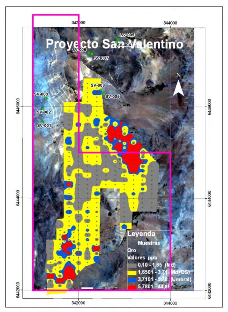
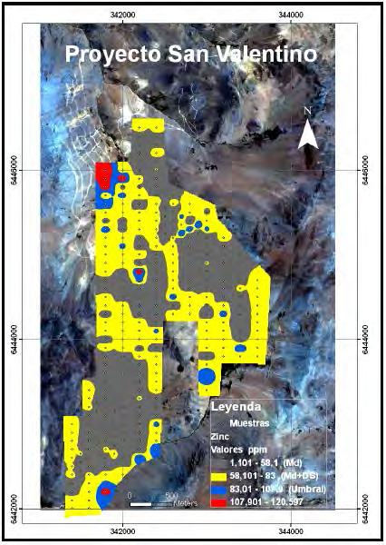
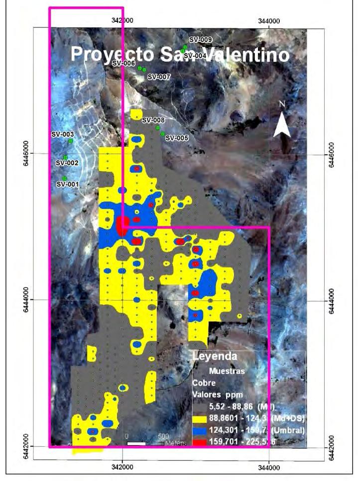
109 GEOCHEMICAL ZONATION PATTERNS - SAN VALENTINO
110 PROJECT FACT SHEETS SECTION 3. AVAILABLE FOR OPTION/JV - IOCG T4 Las Animas Morsas
 type deposits. Strong indications of gold, iron and base metals occur on the T4 property.")
111 T4 August 2015 T4 is situated along the highly productive Coastal Mineral Belt in northern Chile which hosts numerous important iron, copper and gold mines and projects, including numerous "IOCG" (Iron-Oxide-Copper-Gold) type deposits. Strong indications of gold, iron and base metals occur on the T4 property. LOCATION OWNERSHIP PROPERTY SIZE STATUS DEPOSIT TYPE STAGE INFRASTRUCTURE Northern Chile, 2 hour s drive S of Antofagasta 185 Km N-NE of Manto Verde Mine (Anglo American) 100% Revelo ~ 4,700 Ha Available for JV IOCG Copper - Gold - Iron Geological mapping, surface geochemistry, ground magnetics surveys Easy access alongside Pan-American Highway Moderate altitudes of approximately 2,100 m T4
112 LOCATION T4 is located in northern Chile in a similar geological setting and approximately 185 Km north-northeast of the Manto Verde copper mine (Anglo American) that has a reported historic total resource of approximately 0.75% Cu (current proven and probable reserves of 0.53% Cu - heap leach & SX- EW*), and some 160 Km south of the Mantos Blancos copper mine (Anglo American proven and probable reserves of 0.78% Cu - flotation - and 0.45% Cu - heap leach & SX-EW *). OWNERSHIP T4 consists of approximately 4,700 Ha of 100% owned tenement comprising exploration concessions. Revelo controls three IOCG-style projects along the Coastal Belt of northern Chile, at T4, Las Animas and Morsas, totalling approximately 40,000 Ha. T4 is located along the northern extensions of the IOCG belt, and is considered to be drill ready. Las Animas and Morsas are located in the heart of the IOCG belt, adjacent to, and along trend from, the Manto Verde mine of Anglo American and the Candelaria mine of Lundin Mining, respectively. STATUS Revelo is actively looking for a partner to explore the T4 property. GEOLOGY AND DEPOSIT TYPE T4 lies to the immediate west of the Paleocene Volcanic and Mineral Belt of northern Chile, and within the geologically older Coastal Belt Cordillera, which is host to a variety of IOCG-style (Fe-Cu-Au), manto, porphyry and precious metals mines, deposits and occurrences. The Coastal Cordillera is characterized by extensive arc-parallel shear zones and brittle faults, dominated by the Atacama fault zone in northern Chile. Such structures were active during Late Jurassic to Late Cretaceous arc magmatism, controlled basin development, and had a strong controlling influence on the distribution of IOCG and other ore deposits. IOCG mineralization styles include veins, hydrothermal breccias, replacement mantos, and calcic skarns, with the larger deposits generally exhibiting several of these in combination.
113 The T4 property consists of a low hill surrounded by flat 'pampas' made up of post-mineral colluvial and alluvial deposits. Late Jurassic volcanic rocks of the prospective La Negra Formation form the main outcrops on the T4 hill, and these have been extensively hydrothermally altered (silicification, argillic alteration and advanced argillic alteration) with associated characteristic red, earthy hematite. Specular hematite breccias occur within the Jurassic volcanic rocks at the base of the hill to the north, which have yielded highly anomalous values in gold, and a significant magnetic anomaly underlays the altered outcrops, suggesting the presence of a large magnetite-rich body at shallow depths. This is the principal target, although secondary anomalies occur under the "pampa" cover materials to the north and northeast. The property is prospective for IOCG-style copper and gold mineralisation, and possibly iron in the form of magnetite. EXPLORATION Exploration activities to date have included geological mapping of outcropping areas; wide-spaced surface geochemical sampling surveys of colluvial deposits and soils (talus fines) across the main outcropping areas; ground magnetics survey over most of the property; modelling of magnetics data to determine the shape, size and depth of the magnetic bodies; and detailed spectral analysis of talus fines samples and rock chip samples for clay mineral mapping. The resulting information suggests T4 is a relatively un-eroded, high level IOCG target ready for drill testing. INFRASTRUCTURE T4 is easily accessed, being located alongside the Pan- American Highway some two hours' drive from either the port cities of Antofagasta or Taltal, and is situated at moderate altitudes ranging from around 2,100 m to 2,200 m. Qualified Person Dr. Demetrius Pohl, PhD., Certified Professional Geoscientist (CPG), an independent consultant, is the Company's Qualified Person for the purposes of National Instrument Standards of Disclosures for Mineral Projects of the Canadian Securities Administrators, and is responsible for the accuracy of, and has verified the technical information in, this project summary, and has approved its written disclosure. Notes (*) As of December 31, see external Anglo American website: see Ore Reserves and Mineral Resources Annual Report 2013
114 LOCATION MAP
115 REGIONAL GEOLOGY MAP

116 GROUND MAGNETICS TOTAL FIELD DATA - T4
 type deposits. It is centred just 13Km to the northwest of the Manto Verde IOCG copper mine (Anglo American).")
117 LAS ANIMAS August 2015 Las Animas is situated along the highly productive Coastal Mineral Belt in northern Chile which hosts numerous important iron, copper and gold mines and projects, including numerous "IOCG" (Iron-Oxide- Copper-Gold) type deposits. It is centred just 13Km to the northwest of the Manto Verde IOCG copper mine (Anglo American). LOCATION OWNERSHIP PROPERTY SIZE STATUS DEPOSIT TYPE STAGE INFRASTRUCTURE Northern Chile, 1 hour s drive SE of Chañaral 13 Km NW of Manto Verde Mine (Anglo American) 100% Revelo ~ 5,000 Ha Available for JV IOCG Copper Gold Early stage Moderate access - dirt roads off Pan-American Highway Moderate altitudes of approximately 800 m Las Animas
118 LOCATION Las Animas is located in northern Chile in a similar geological setting to, approximately 13 Km northwest of, the Manto Verde copper mine (Anglo American) with a reported historic total resource of approximately 0.75% Cu (current proven and probable reserves of 0.53% Cu - heap leach & SX-EW *), and some 115 Km north-northwest of the Candelaria copper-gold mine (Lundin Mining) that has published reserves and resources of approximately 0.5% Cu + 0.1g/t Au + 1.9g/t Ag ** in open pit, together with additional, higher grade underground resources. OWNERSHIP Las Animas consists of approximately 5,000 Ha of 100% owned tenement comprising exploration and mining concessions. Revelo controls three IOCG-style projects along the Coastal Belt of northern Chile, at T4, Las Animas and Morsas, totalling approximately 40,000 Ha. T4 is located along the northern extensions of the IOCG belt, and is considered to be drill ready. Las Animas and Morsas are located in the heart of the IOCG belt, adjacent to, and along trend from, the Manto Verde mine of Anglo American and the Candelaria mine of Lundin Mining, respectively. STATUS Revelo is actively looking for a partner to explore the Las Animas property. GEOLOGY AND DEPOSIT TYPE Las Animas lies within the Coastal Belt Cordillera, which is host to a variety of IOCG-style (Fe-Cu-Au), manto, porphyry and precious metals mines, deposits and occurrences. The Coastal Cordillera is characterized by extensive arc-parallel shear zones and brittle faults, dominated by the Atacama fault zone in northern Chile. Such structures were active during Late Jurassic to Late Cretaceous arc magmatism, controlled basin development, and had a strong controlling influence on the distribution of IOCG and other ore deposits. IOCG mineralization styles include veins, hydrothermal breccias, replacement mantos, and calcic skarns, with the larger deposits generally exhibiting several of these
119 in combination. The detailed geology of Las Animas is poorly known, but Jurassic age (ca Ma) granodioritic to dioritic bodies intrude andesitic volcanic sequences of the Jurassic age La Negra Fm, one of the key host rocks for IOCG deposits in northern Chile. North-south and northwest-southeast trending structures cross-cut the property, parallel to regional and more local fault orientations. A series of artisanal mine workings occur within small, third-party in-holdings within the outer property boundary. Oxide copper is currently being worked, or has been worked in the past, from a series of vein-like structures characterised by the presence of specular hematite. Many of these mineral workings are also anomalous in gold. Stream sediment samples across the property show extensive copper anomalies, and lesser gold anomalies in several potential target areas. The property is prospective for IOCG-style copper and gold mineralisation. EXPLORATION Exploration activities to date have included basic geological mapping of outcropping areas and stream sediment sampling across the property. INFRASTRUCTURE Las Animas is relatively easily accessed, being located close to Chañaral and the Pan-American Highway. Local access into the interior of the property requires hiking. The property is situated at moderate altitudes ranging from around 700 m to1,000 m. Qualified Person Dr. Demetrius Pohl, PhD., Certified Professional Geoscientist (CPG), an independent consultant, is the Company's Qualified Person for the purposes of National Instrument Standards of Disclosures for Mineral Projects of the Canadian Securities Administrators, and is responsible for the accuracy of, and has verified the technical information in, this project summary, and has approved its written disclosure. Notes * As of December 31, see external Anglo American website: see Ore Reserves and Mineral Resources Annual Report 2013 ** As of June 30, see external Lundin Mining website:
120 LOCATION MAP
121 REGIONAL GEOLOGY MAP


122 SATELLITE IMAGE SHOWING LAS ANIMAS & MANTO VERDE MINE WORKINGS Las Animas Property Boundary
 type deposits.")
123 MORSAS August 2015 Morsas comprises an extensive group of properties situated along the highly productive Coastal Mineral Belt in northern Chile which hosts numerous important iron, copper and gold mines and projects, including numerous "IOCG" (Iron-Oxide-Copper-Gold) type deposits. The properties are located along trend and to the southwest of Lundin Mining s Candelaria copper-gold mine, situated to the south of Copiapo. LOCATION OWNERSHIP PROPERTY SIZE STATUS DEPOSIT TYPE STAGE INFRASTRUCTURE Northern Chile, 1 hours drive S of Copiapo or 1.5 hours drive N of Vallenar Approximately 50 Km SW of Candelaria Mine (Lundin) 100% Revelo 2% NSR on precious metals + 1% on base metals (50% purchasable) for portion acquired from BLC SpA ~ 30,000 Ha Available for JV IOCG Copper-Gold-Iron / Shear-Zone Gold Early stage - reconnaissance mapping & geochemical sampling Easy access alongside Pan-American Highway Low altitudes of approximately 250 m to 750 m Morsas
124 LOCATION Morsas is located in northern Chile in a similar geological setting to, and approximately 50 Km southwest of, the Candelaria copper-gold mine (Lundin Mining) that has published reserves and resources of approximately 0.5% Cu + 0.1g/t Au + 1.9g/t Ag * in open pit, together with additional, higher grade underground resources. Historically mined material is of higher grades. OWNERSHIP Morsas comprises approximately 30,300 Ha of 100% owned tenement comprising exploration concessions, originally acquired from BLC SpA, a Chilean subsidiary of Altius Minerals Corp. A 2% NSR royalty on precious metals and 1% NSR royalty on base metals, 50% of which is purchasable at any time up to a limit of five years following the commencement of commercial production of mineral products from the property, for a total cash payment of $5M, is applicable to the property. Revelo controls three IOCG-style projects along the Coastal Belt of northern Chile, at T4, Las Animas and Morsas, totalling approximately 40,000 Ha. T4 is located along the northern extensions of the IOCG belt, and is considered to be drill ready. Las Animas and Morsas are located in the heart of the IOCG belt, adjacent to, and along trend from, the Manto Verde mine of Anglo American and the Candelaria mine of Lundin Mining, respectively. BLC SpA ACQUISITION In July 2015, Revelo concluded the acquisition of Morsas together with three other properties from BLC SpA, the 49% owned Chilean subsidiary of Altius Minerals Corporation (News Release dated July 6, 2015). As part of the acquisition, Revelo: Issued 2,775,773 common shares of Revelo valued at C$250,000; Will issue 500,000 common shares on completion of the first feasibility study on any one of the (four) Properties (in respect of all of the Properties, no matter how many feasibility studies may be completed); and
125 Granted a royalty of 2% of net smelter returns from commercial production of precious metals and 1% of net smelter returns from commercial production of base metals from each of the Properties. Revelo will have the right to purchase one-half of the Royalties in respect of each of the Properties for C$5 million, which right will be exercisable any time up to a limit of five years following the commencement of commercial production of mineral products from the relevant Property. STATUS Revelo is actively looking for a partner to explore the Morsas property. GEOLOGY AND DEPOSIT TYPE Morsas lies along the Coastal Belt Cordillera, which is host to a variety of IOCG-style (Fe-Cu-Au), manto, porphyry and precious metals mines, deposits and occurrences. The Coastal Cordillera is characterized by extensive arc-parallel shear zones and brittle faults, dominated by the Atacama fault zone in northern Chile. Such structures were active during Late Jurassic to Late Cretaceous arc magmatism, controlled basin development, and had a strong controlling influence on the distribution of IOCG and other ore deposits. IOCG mineralization styles include veins, hydrothermal breccias, replacement mantos, and calcic skarns, with the larger deposits generally exhibiting several of these in combination. Morsas consists of several property blocks collectively covering a series of areas along 75 Km of the prospective trend, centred to the southwest of the Candelaria Cu-Au mine of Lundin Mining, as well as being located along trend of the Los Colorados, Boqueron Chañar and Cerro Iman iron-ore deposits. Multiple small scale, artisanal workings for copper, iron and gold occur in the district, many of which are IOCGrelated, but also include shear-zone gold occurrences related to strands of the Atacama Fault Zone. Much of the area is obscured by shallow, post-mineral gravel and colluvial cover, but is punctuated by small hills and outcrops, as well as mineral workings, giving evidence to the underlying geology. The property is prospective for IOCG-style copper and gold mineralisation, possibly iron in the form of magnetite, and shear-zone hosted gold. Morsas is underlain by favorable stratigraphic sequences of the Punta del Cobre (lower Cretaceous) and La Negra formations (Upper Jurassic), together with Cretaceous plutonic rocks, and is transected by several major structures related to the Atacama Fault System. Copper-gold mineralization visible at surface is related to veins and shear zones that display alteration with affinities to IOCG-type deposits. The presence of specular hematite, calcite, ankerite, epidote and chlorite together with copper-oxide mineralization and quartz-sericite alteration suggests the potential for IOCG-style mineralization beneath shallow cover within the principal concession areas to the north. Additionally, several auriferous shear zones mined on a small scale historically extend beneath shallow cover onto the Morsas property, providing a secondary target type for follow-up exploration. Grab samples from old workings returned highly anomalous gold values. EXPLORATION The results of historic exploration on the Morsas property are unknown to Revelo. To date, only basic reconnaissance mapping and sampling has been completed on the property. More detailed geological mapping, geochemical sampling, and processing of state-flown airborne magnetics data is planned for the near future. INFRASTRUCTURE Morsas is easily accessed, being located alongside the Pan-American Highway some one hours' drive from Copiapo, or a slightly longer drive from Vallenar, depending on which portion of the property is to be accessed, and is situated at low altitudes ranging from around 250 m to 750 m.
126 Qualified Person Dr. Demetrius Pohl, PhD., Certified Professional Geoscientist (CPG), an independent consultant, is the Company's Qualified Person for the purposes of National Instrument Standards of Disclosures for Mineral Projects of the Canadian Securities Administrators, and is responsible for the accuracy of, and has verified the technical information in, this project summary, and has approved its written disclosure. Notes (*) As of June 30, see external Lundin Mining website:
127 LOCATION MAP
128 REGIONAL GEOLOGY MAP
129 PROJECT FACT SHEETS SECTION 4. AVAILABLE FOR OPTION/JV. Au+Ag Magallanes Loro San Guillermo

130 MAGALLANES August 2015 Magallanes is a small, strategically located property along the highly productive Paleocene Mineral Belt in northern Chile that contains numerous important gold, silver and copper mines and projects. One main vein on the property, the Veinticinco Vein, has been worked to shallow depths by artisanal miners in the past. Several other vein structurescut across the property. LOCATION OWNERSHIP PROPERTY SIZE STATUS DEPOSIT TYPE STAGE INFRASTRUCTURE Northern Chile, 1.5 hours drive SE of Antofagasta 50 Km N of El Peñon Mine (Yamana Gold) 100% Revelo ~ 1,800 Ha Available for JV Epithermal Gold-Silver Geological mapping, rock chip sampling and trenching Easy access - short drive from Antofagasta-Escondida road Modest altitudes of approximately 1,800 m Magallanes
131 LOCATION Magallanes is located in northern Chile along trend and approximately 50 Km north of the highly productive El Peñon and Fortuna gold-silver mines (Yamana Gold) (proven and probable reserves of 5.83 g/t Au g/t Ag 1.96Moz Au Moz Ag *), and only 25 Km north of the recent discovery at Pampa Augusta Victoria (Yamana Gold). OWNERSHIP Magallanes consists of approximately 1,800 Ha of 100% owned tenement comprising both exploration and mining concessions. Revelo controls a highly prospective and strategic land position along the Paleocene Mineral Belt, with the Las Pampas, Loro and San Guillermo properties - totaling around 85,000 Ha - being wholly-owned, and complemented by the Magallanes property. All four properties contain abundant evidence for the main vein-hosted style of precious metals mineralization sought, and all four are located close to and along trend from either producing mines or significant inground mineral resources. STATUS Revelo is actively looking for a partner to explore the Magallanes property. GEOLOGY AND DEPOSIT TYPE The Magallanes property includes approximately 416 Ha covering the Veinticinco Vein and immediate environs, together with a further 1,400 Ha covering nearby areas, and is located along the northern extensions of the prospective Dominador Fault Zone, and lies within the Paleocene volcanic belt of northern Chile that hosts some of the most important precious metals and copper deposits in the country. District geology comprises basaltic to rhyolitic, pyroclastic and flow units, sub-volcanic dacites and rhyolites, and volcanic breccias of Late Cretaceous to Early Eocene age, related to the extensional Paleoceneaged magmatic arc that developed to the east of the Coastal Belt Jurassic magmatic arc. In the vicinity of Magallanes, these rocks are underlain by Palaeozoic
132 and Mesozoic sedimentary and volcanic rocks, which host all mineralized structuresidentified to date. The property comprises a small topographic high rising out of the surrounding post-mineral, gravel-covered pampas. The property is prospective for high-grade, vein-style, epithermal precious metals mineralization of lowsulphidation type. One principal vein on the property, the Veinticinco Vein, has several shallow workings reflecting historic artisanal mining along its more than 1 Km strike length. Rock-chip sampling of existing workings and trenching in selected areas indicates potential for high-grade gold and silver mineralization over narrow widths. EXPLORATION Geological mapping, rock chip sampling of outcrops in old workings, and trenching of accessible extensions to the vein have been completed. Results indicate potential for high-grade mineralisation over narrow widths (Iron Creek News Release May 30, 2012). INFRASTRUCTURE Magallanes is easily accessed, being located within a short driving distance from the main paved road that connects the port city of Antofagasta with the giant copper mine at La Escondida (BHP Billiton-Rio Tinto), some 1.5 hours drive from Antofagasta. The property is situated at modest altitudes of around 1,800 m. Qualified Person Dr. Demetrius Pohl, PhD., Certified Professional Geoscientist (CPG), an independent consultant, is the Company's Qualified Person for the purposes of National Instrument Standards of Disclosures for Mineral Projects of the Canadian Securities Administrators, and is responsible for the accuracy of, and has verified the technical information in, this project summary, and has approved its written disclosure. Notes (*) As of December 31, 2013 see external Yamana Gold website:
133 LOCATION MAP
134 REGIONAL GEOLOGY MAP

135 PRINCIPAL TRENCH RESULTS FROM VEINTICINCO VEIN - MAGALLANES
136 GEOLOGICAL & GEOCHEMICAL MODELS FOR EL PEŇON STYLE LS VEIN SYSTEMS El Peñon Geologic Model Note multiple extrusive/intrusive rhyolite domes, near horizontal intercalated volcanics, characteristic lithologic types (flow banded rhyolite, spherulitic, sanidine, and breccia or fragmental rhyolite), zoned hydrothermal alteration, and hematite & arsenic anomalies capping mineralized veins and breccias (Modified from Perez, 1999) Trace Elements Distribution Model at El Peñon Low Sulphidation Gold/Silver Deposits Note the wide arsenic cap over the LS veins, as well as the generalized >100m wide anomalous silver (~ 2 ppm) envelope around the ore-grade gold/silver mineralized structure (Compiled from Gonzalez, 2001)

137 LORO August 2015 Loro is located along the highly productive Paleocene Mineral Belt in northern Chile that contains several important gold, silver and copper mines and projects. Several indications of epithermal vein related gold and silver mineralisation occur on the property, which has not been subject to historic exploration. The property lies along trend to the south of the El Peñon gold-silver mine, and east of Revelo s Las Pampas project. LOCATION OWNERSHIP PROPERTY SIZE STATUS DEPOSIT TYPE STAGE INFRASTRUCTURE Northern Chile, 140 Km SE of Antofagasta 25 Km S of El Peñon mine (Yamana Gold) 100% Revelo 2% NSR on precious metals + 1% on base metals (50% purchasable) for portion acquired from BLC SpA ~ 5,200 Ha Available for JV Epithermal Gold-Silver Early stage - basic reconnaissance Easy access modest drive from Pan-American Highway Modest altitude of approximately 1,900 m Loro
, and immediately east of Revelo's Las Pampas property.")
138 LOCATION Loro is located in northern Chile in the same geological setting as, and approximately 25 Km south of, the highly productive El Peñon and Fortuna gold-silver mines (Yamana Gold proven and probable reserves of 5.83 g/t Au g/t Ag 1.96Moz Au Moz Ag *), and immediately east of Revelo's Las Pampas property. OWNERSHIP Loro consists of approximately 5,200 Ha of 100% owned tenement comprising exploration concessions, originally acquired from BLC SpA, a Chilean subsidiary of Altius Minerals Corp. A 2% NSR royalty on precious metals and 1% NSR royalty on base metals, 50% of which is purchasable at any time up to a limit of five years following the commencement of commercial production of mineral products from the property, for a total cash payment of $5M, is applicable to the property. Revelo controls a highly prospective and strategic land position along the Paleocene Mineral Belt, with the Las Pampas, Loro and San Guillermo properties totaling around 67,750 Ha being wholly-owned, and complemented by the Magallanes property. All four properties contain abundant evidence for the main vein-hosted style of precious metals mineralization sought, and all four are located close to and along trend from either producing mines or significant inground mineral resources. BLC SpA ACQUISITION In July 2015, Revelo concluded the acquisition of Loro together with three other properties from BLC SpA, the 49% owned Chilean subsidiary of Altius Minerals Corporation (News Release dated July 6, 2015). As part of the acquisition, Revelo: Issued 2,775,773 common shares of Revelo valued at C$250,000; Will issue 500,000 common shares on completion of the first feasibility study on any one of the (four) Properties (in respect of all of the Properties, no matter how many feasibility studies may be completed); and
139 Granted a royalty of 2% of net smelter returns from commercial production of precious metals and 1% of net smelter returns from commercial production of base metals from each of the Properties. Revelo will have the right to purchase one-half of the Royalties in respect of each of the Properties for C$5 million, which right will be exercisable any time up to a limit of five years following the commencement of commercial production of mineral products from the relevant Property. STATUS Revelo is actively looking for a partner to explore the Loro property. GEOLOGY AND DEPOSIT TYPE The Loro claims are located in the Paleocene to early Eocene volcanic belt of northern Chile, that hosts some of the most important precious metals and copper deposits in the country. District geology comprises basaltic to rhyolitic, pyroclastic and flow units, subvolcanic dacites and rhyolites, and volcanic breccias of Late Cretaceous to Early Eocene age, related to the extensional Paleocene-aged magmatic arc that developed to the east of the Coastal Belt Jurassic magmatic arc. These rocks are underlain by Lower Cretaceous sedimentary and volcanic rocks. Major structures are dominated by basin-bounding fault systems, including the important Dominador Fault Zone to the west and the Domeyko Fault Zone to the east, and related second-order fault splays. The property is prospective for high-grade, vein-style, epithermal precious metals mineralization of lowsulphidation type. Approximately 25 Km due north of the Loro property, mineralisation at the El Peñon mine of Yamana Gold is developed along a series of N-striking and steeply W and E dipping quartz-adularia precious metals veins developed in, and adjacent to, felsic intrusions and domes. The Loro area displays numerous, parallel, N-S trending float occurrences likely related to a branching array of veins associated with regional faults, similar to El Peñon. These occurrences are associated with a series of rhyolite to rhyodacite domes outcropping along district faults on the western slopes of the Cerros de Cebada at Loro, and have been mapped as Middle Palaeocene Volcanic Sequences. These possible domes present a characteristic light brown-reddish color in the landscape caused by hematite staining, typically associated with low sulphidation epithermal veins and related hydrothermal breccias. The rocks exposed within the Loro area are likely to be similar to, and correlated with, the El Peñon volcanic stratigraphy. As at El Peñon, rhyolite and dacite flows and minor pyroclastic and volcaniclastic rocks which outcrop within the Loro claims, are very probably associated with a rhyolite dome complex that extends for at least 2 Km E-W and 4 Km N-S along the western slopes of the Perla-Cebada range. EXPLORATION Minimal exploration has been carried out to date on the property, which is an exciting but raw prospect. The lack of vehicle tracks, and any other evidence of human activity, suggests that Loro has not been explored or perhaps even visited historically. Revelo plans to carry out detailed geological mapping of the property, complemented by soil traverses and rock-chip sampling where appropriate. INFRASTRUCTURE Loro is easily accessed, being located within a modest driving distance from the Pan-American Highway along a well-maintained dirt road, some 3 hours' drive from Antofagasta and 2 hours from Taltal. The property is situated at modest altitudes ranging from around 1,850 m to 1,950 m.
140 Qualified Person Dr. Demetrius Pohl, PhD., Certified Professional Geoscientist (CPG), an independent consultant, is the Company's Qualified Person for the purposes of National Instrument Standards of Disclosures for Mineral Projects of the Canadian Securities Administrators, and is responsible for the accuracy of, and has verified the technical information in, this project summary, and has approved its written disclosure. Notes (*) As of December 31, 2014 see external YamanaGold website:
141 LOCATION MAP
142 REGIONAL GEOLOGY MAP

143 SATELLITE IMAGE TO SHOW LOCATION OF LORO IN RELATION TO: LAS PAMPAS PROJECT - REVELO / KINROSS OPTION EL PEŇON & FORTUNA MINES - YAMANA GOLD 10 Km
144 DISTRICT SCALE GEOLOGY MAP - LORO & LAS PAMPAS MINERA MENA CHILE LIMITADA Paleocene Belt Northern Chile Las Pampas - El Penon - Cebada (Loro) District Geology & Road Access Map April To Km 1258 Ruta 5 Norte ^_ Fortuna Fault ^_ El Peñon SQM Poligrama SQ Co. Pa KM 1258 Dominador Water Wells ^_ Lagarto ^_ Melinda Pampa El Penon Ruta 5 Norte ^_ Veta H PBA ^_ Cº Blanco KM 1237 ^_ Loro Veins ^_ Cº Buenos Aires Cerros Bayos Acarreos Norte Acarreos Sur Cerritos Centro Cerritos ^_ Norte (Garuma) Cerritos Sur ^_ Legend Route To Loro Mines & Prospects LandTenem_Pampas_Jul2013 Pedimentos_Oregano_Marzo_26 Oregano_Loro_Property LandTenem_PBA_Dec ^_ El Soldado T4
, zoned hydrothermal alteration, and hematite &")
 envelope around the ore-grade gold/silver mineralized structure (Compiled")
145 GEOLOGICAL & GEOCHEMICAL MODELS FOR EL PEŇON STYLE LS VEIN SYSTEMS El Peñon Geologic Model Note multiple extrusive/intrusive rhyolite domes, near horizontal intercalated volcanics, characteristic lithologic types (flow banded rhyolite, spherulitic, sanidine, and breccia or fragmental rhyolite), zoned hydrothermal alteration, and hematite & arsenic anomalies capping mineralized veins and breccias (Modified from Perez, 1999) Trace Elements Distribution Model at El Peñon Low Sulphidation Gold/Silver Deposits Note the wide arsenic cap over the LS veins, as well as the generalized >100m wide anomalous silver (~ 2 ppm) envelope around the ore-grade gold/silver mineralized structure (Compiled from Gonzalez, 2001)

146 SAN GUILLERMO August 2015 San Guillermo is strategically located along the highly productive Paleocene Mineral Belt in northern Chile that contains several important gold, silver and copper mines and projects. Numerous indications of gold and silver mineralisation occur on the property, including several drill intercepts. The property surrounds the Amancaya precious metals mining project of Austral Gold. LOCATION OWNERSHIP PROPERTY SIZE STATUS DEPOSIT TYPE STAGE INFRASTRUCTURE Northern Chile, 3 hours drive S of Antofagasta Surrounds Amancaya Project (Austral Gold) 100% Revelo 2% NSR on precious metals + 1% on base metals (50% purchasable) for portion acquired from Minera Fuego ~ 12,500 Ha Available for JV Epithermal Gold-Silver Early stage with approximately 41,000 m drilling on several targets to date Easy access short drive from Pan-American Highway Modest altitude of approximately 2,000 m San Guillermo
147 LOCATION San Guillermo is located in northern Chile in the same geological setting as, and approximately 135 Km southsouthwest of, the highly productive El Peñon and Fortuna gold-silver mines (Yamana Gold proven and probable reserves of 5.83 g/t Au g/t Ag 1.96Moz Au Moz Ag *), and some 100 Km south of Revelo's Las Pampas property. San Guillermo surrounds the Amancaya Project (Austral Gold) with an inferred resource of 7.9 g/t Au + 73 g/t Ag (351,000 oz Au M oz Ag*). OWNERSHIP San Guillermo consists of approximately 29,600 Ha of 100% owned tenement comprising both exploration and mining concessions. 24,815 Ha were acquired from Minera Fuego, and the remainder of the property was staked by Revelo. A 2% NSR royalty on precious metals and 1% NSR royalty on base metals, 50% of which is purchasable at any time for a total cash payment of $5M, is applicable to the portion of the property acquired from Minera Fuego. Additionally, within the area acquired from Minera Fuego, properties totalling 1,437 Ha are subject to an underlying NSR royalty of 2%. Revelo controls a highly prospective and strategic land position along the Paleocene Mineral Belt, with the Las Pampas, Loro and San Guillermo properties totaling around 85,000 Ha being wholly-owned, and complemented by the Magallanes property. All four properties contain abundant evidence for the main vein-hosted style of precious metals mineralization sought, and all four are located close to and along trend from either producing mines or significant inground mineral resources. MINERA FUEGO ACQUISITION In May 2014, Revelo (as Iron Creek Capital Corp.) acquired from Minera Fuego Limitada, a privately owned Chilean exploration company, a 100% interest in five properties prospective for gold, silver and copper, located in northern Chile, including San Guillermo (Iron Creek News Releases dated May 6, 2014 and July 22, 2014). Revelo granted to Minera Fuego a 2% NSR on precious metals and a 1% NSR on base metals mined from the properties acquired
148 (the"nsr Royalties"). Revelo shall have the perpetual right to acquire 50% of each of these NSR Royalties on each property in consideration of a total cash payment to Minera Fuego of USD 5.0 million, on a property by property basis. Additionally, within the area at San Guillermo acquired from Minera Fuego, properties totaling 1,437 Ha are subject to an underlying NSR royalty of 2%. Revelo issued 3,479,464 common shares (9.9% of the issued and outstanding share capital at the time), and it shall issue a further 1M common shares to Minera Fuego upon completion of its first feasibility study regarding a project to be developed on any one of the properties. Following closing, Revelo appointed a representative of Minera Fuego to its Board of Directors and Minera Fuego shall have the right to designate a member of the Board so long as it owns more than 5% of the Company's common shares. STATUS Revelo is actively looking for a partner to explore the San Guillermo property. GEOLOGY AND DEPOSIT TYPE San Guillermo covers approximately 35 km of continuous strike length of the prospective Dominador Fault Zone, and lies within the Paleocene volcanic belt of northern Chile that hosts some of the most important precious metals and copper deposits in the country. The property surrounds the Amancaya project of Austral Gold (purchased from Yamana Gold see Austral Gold News Release dated June 17, 2014), which hosts a series of high-grade, low-sulphidation epithermal gold and silver veins of early Paleocene age (ca Ma). District geology comprises basaltic to rhyolitic, pyroclastic and flow units, sub-volcanic dacites and rhyolites, and volcanic breccias of Late Cretaceous to Early Eocene age, related to the extensional Paleoceneaged magmatic arc that developed to the east of the Coastal Belt Jurassic magmatic arc. These rocks are underlain by Lower Cretaceous sedimentary and volcanic rocks. Major structures are dominated by basin-bounding fault systems, including the important Dominador Fault Zone to the west and the Domeyko Fault Zone to the east, and related second-order fault splays. The property is prospective for high-grade, vein-style, epithermal precious metals mineralization of lowsulphidation type, principally on the western half of the property, along trend to the north and south of the Amancaya veins (Austral Gold). An important splay of the Dominador Fault Zone appears to pass approximately N-S through the centre of the property, and likely plays an important role on controlling the location of potential mineralised vein systems on the property. Several low-sulphidation epithermal (quartzadularia-illite related) gold and silver vein targets occur on the property, particularly at Amancaya Sur, Baron Rojo, Amancaya Norte and Rosario NW, and have in part been tested by drilling. An additional target occurs at Morros Blancos, where advanced argillic alteration of (likely) early Paleocene age together with anomalous surface geochemical anomalies in Mo, As, Bi, Se, Te suggests potential for high-sulphidation precious metals mineralisation and/or a deep porphyry copper target. Revelo is considering dividing the property into two parts, in recognition of the two principal target types: LS epithermal veins along the Amancaya trend Porphyry copper beneath a HS lithocap at Morros Blancos EXPLORATION Significant portions of the property are characterized by large, post-mineral, gravel-covered pampas, where surface geochemistry, float mapping, trenching and geophysics are the main exploration tools prior to drilling. Exploration activities to date have included geological mapping of outcropping areas; restricted areas of surface MMI geochemical sampling grids; trenching of some geochemical anomalies; limited areas of geophysical coverage including magnetics and IP; and drill testing (46,000 m of drilling was completed in several phases) of several widely spaced targets. Surface geochemical sampling and ph analyses are being extended across the property and additional geological mapping of outcrops and trenches is being carried out. Historic data and newly acquired data have been recompiled and target models are being refined.
149 The best drill results include: Hole SG-028 2m (from 207m to 7.18g/t Au+13.8g/t Ag Hole SG-051 2m (from 352m to 17.94g/t Au+6.8g/t Ag Hole SG-054 4m (from 146m to 1.27g/t Au+78.5g/t Ag Hole SG-063 2m (from 94m to 6.13g/t Au g/t Ag Hole SGD-01 1m (from 247m to 248m)@11.89g/t Au+12.7g/t Ag Hole SGD-02 1m (from 200m to 201m)@10.44g/t Au + 7.4g/t Ag These drill results suggest significant potential for mineralised epithermal veins of the type sought, along trend from the defined resource at Amancaya, within the western half of the property. INFRASTRUCTURE San Guillermo is easily accessed, being located within a short driving distance from the Pan-American Highway along a well-maintained dirt road, some 3 hours' drive from Antofagasta and 1½ hours from Taltal. The property is situated at modest altitudes ranging from around 1,900 m to 2,100 m. Qualified Person Dr. Demetrius Pohl, PhD., Certified Professional Geoscientist (CPG), an independent consultant, is the Company's Qualified Person for the purposes of National Instrument Standards of Disclosures for Mineral Projects of the Canadian Securities Administrators, and is responsible for the accuracy of, and has verified the technical information in, this project summary, and has approved its written disclosure. Notes (*) As of December 31, 2013 see external YamanaGold website:
150 LOCATION MAP
151 REGIONAL GEOLOGY MAP

152 SCHEMATIC MAP WITH KEY AREAS OF INTEREST

153 SCHEMATIC MAP OF CENTRAL AMANCAYA AREA
154 PROJECT FACT SHEETS SECTION 5. ROYALTY AGREEMENTS Victoria

155 VICTORIA August 2015 Victoria is a large property situated along the Domeyko Cordillera porphyry copper belt in northern Chile, which is host to some of the world s largest copper deposits and mines. The property is owned by a third party, but Revelo is the beneficiary of an uncapped 2% NSR royalty on any future production from the property. Victoria is contiguous with Revelo s Block 4-Anaconda property. LOCATION OWNERSHIP PROPERTY SIZE STATUS DEPOSIT TYPE Northern Chile, 3 hours drive SE of Antofagasta Midway between the La Escondida (BHP Billiton & Rio Tinto) and El Salvador (Codelco) Mining Districts 100% Hochschild Mining Holdings Ltd Revelo retains a 2% NSR royalty interest ~ 45,000Ha Owned and operatedby Hochschild Revelo retains a 2% NSR royalty interest Porphyry Copper and Epithermal Gold-Silver STAGE INFRASTRUCTURE Multiple exploration campaigns, including drilling Good quality dirt road from Pan-American Highway Altitude of approximately 3,300 m Victoria
156 LOCATION Victoria is located in northern Chile along the Domeyko Cordillera porphyry copper belt in northern Chile, which is host to some of the world s largest copper deposits and mines. The property is located approximately 225 Km southeast of the coastal port city of Antofagasta, and is situated along trend and approximately 125 Km south-southwest of the giant Escondida copper mine and other related copper deposits in the district (BHP Minerals & Rio Tinto). Victoria is contiguous with, and lies to the immediate west of, Revelo s Block 4-Anaconda property. OWNERSHIP & STATUS Victoria consists of approximately 45,000 Ha of tenement and is owned and operated by a subsidiary of Hochschild Mining Holdings Ltd. Revelo retains a 2% uncapped NSR royalty interest on the property (Iron Creek News Release April 8, 2013). GEOLOGY AND DEPOSIT TYPE Victoria is located in northern Chile along the Domeyko Cordillera, which represents the Late Eocene-Oligocene magmatic arc of northern Chile, and which is host to three of the world's top five copper mines at Collahuasi, Chuquicamata and La Escondida (the world s single largest copper mine). The property coversapproximately 37km ofcontinuous strike length along the prospective belt, and has potential for porphyry copper deposits (+/- molybdenum +/- gold) together with genetically related, zoned, high, intermediate, and low-sulphidation epithermal precious metals deposits. Victoria is situated directly along trend of, and approximately midway between, the important La Escondida (BHP Billiton & Rio Tinto) and El Salvador (Codelco) copper mining districts. Porphyry copper targets occur at Picaron, Incahuasi, Cenizas and possibly at depth beneath the Vaquillas Mine area. Further potential for blind porphyry targets under post-mineral cover exists to the north, west and/or southwest of Vetas Negras (Vetas Negras Oeste), in the large covered area between the Quebrada Chaco and the Vaquillas Mine (Chaco), and in the large covered area between the Vaquillas Mine and Picaron (Azul Profundo). Exotic copper mineralisation has been discovered in young gravels to the northeast of Picaron ("Picaron Exotic"), and also in
157 young volcanic rocks to the south of Incahuasi. The Vaquillas Mine area consists of breccias and veins with gold and silver likely representing intermediatesulphidation epithermal mineralization located above and/or lateral to a porphyry copper centre. The Vetas Negras (abandoned by Hochschild in 2010) and Victoria vein systems likely represent distal epithermal silver + manganese veins to one or more porphyry centres. The Nueve Vidas area appears to show characteristics of diorite-hosted, low-grade porphyry gold mineralization, or possibly IOCG-related gold mineralisation, together with cross-cutting, highergrade auriferous structures. The Chaco Quebrada target is a structurally controlled, calcareous sediment hosted, gold and silver target. Other covered, partially covered, and geophysical targets for precious metals and porphyry copper mineralisation occur within the property. EXPLORATION Multiple exploration campaigns have been completed on the property, including several drilling campaigns. Extensive geophysical data (IP and magnetics), geochemical data (rocks, soils and colluvium), and geological mapping have been completed. INFRASTRUCTURE Access to the property is via a good quality dirt road leading off from the Pan-American Highway to the north of Agua Verde. Total journey time from the coastal port town of Taltal in northern Chile is about 2 hours, and from Antofagasta about 3 hours. Altitudes vary from approximately 3,000 m to around 3,400 m. Qualified Person Dr. Demetrius Pohl, PhD., Certified Professional Geoscientist (CPG), an independent consultant, is the Company's Qualified Person for the purposes of National Instrument Standards of Disclosures for Mineral Projects of the Canadian Securities Administrators, and is responsible for the accuracy of, and has verified the technical information in, this project summary, and has approved its written disclosure.

158 LOCATION MAP

159 REGIONAL GEOLOGY MAP

160 SIMPLIFIED SCHEMATIC GEOLOGY & PRINCIPAL TARGETS - VICTORIA
Northern Chile, 170 km SE of Antofagasta Centred km S-SW of the giant La Escondida Mining District (BHP Billiton & Rio Tinto)
") October 2017 Block 3-Culebra is a large property block situated along the Domeyko Cordillera porphyry copper belt in northern Chile, which is host to some of the world s largest copper deposits and mines.
October 2017 Block 3-Culebra is a large property block situated along the Domeyko Cordillera porphyry copper belt in northern Chile, which is host to some of the world s largest copper deposits and mines.
Northern Chile, 85 Km NE of La Serena 125 km S of Relincho (Nueva Union Teck-Goldcorp)
") July 2017 Mirador lies along the southern extensions of the highly productive Paleocene Mineral Belt in northern Chile that contains numerous important copper, gold and silver mines and projects. Mirador
July 2017 Mirador lies along the southern extensions of the highly productive Paleocene Mineral Belt in northern Chile that contains numerous important copper, gold and silver mines and projects. Mirador
CERRO BUENOS AIRES. 100% Revelo Subject to a 1% NSR payable on all metals. ~ 8,400 Ha. Available for Option & JV
 October 2017 Buenos Aires is located in the heart of the highly productive Paleocene Mineral Belt in northern Chile that contains several important gold, silver and copper mines and projects. Large outcrops
Revelo Reports on Initial Drill Test of its Cerro Buenos Aires Project
 www.reveloresources.com NEWS RELEASE # 7 / 2018 Revelo Reports on Initial Drill Test of its Cerro Buenos Aires Project Vancouver September 18, 2018 Revelo Resources Corp. ( Revelo or the Company ) (TSX-V:
LOS AZULES April 2018
 April 2018 lies along the southern extensions of the highly productive Paleocene Mineral Belt in northern Chile that contains numerous important copper, gold and silver mines and projects, and to the south
ADVANCING A PROSPECTIVE PORTFOLIO TO DISCOVERY SUCCESS. Copper - Gold - Silver. PROJECT LISTING PRESENTATION May
 ADVANCING A PROSPECTIVE PORTFOLIO TO DISCOVERY SUCCESS Copper - Gold - Silver PROJECT LISTING PRESENTATION May 2018 Cautionary Statement Certain statements contained in the following presentation constitute
Revelo Completes Geological Review of its Montezuma Copper-Gold Project & Defines Priority Targets
 www.reveloresources.com NEWS RELEASE # 17 / 2017 Revelo Completes Geological Review of its Montezuma Copper-Gold Project & Defines Priority Targets Vancouver December 12, 2017 Revelo Resources Corp. (
Revelo Defines Porphyry Copper Targets at its Calvario Project
 www.reveloresources.com NEWS RELEASE #01/2015 Revelo Defines Porphyry Copper Targets at its Calvario Project Vancouver - February 03, 2015 - Revelo Resources Corp. ( Revelo or the Company ) (TSX-V: RVL)
ADVANCING A PROSPECTIVE PORTFOLIO TO DISCOVERY SUCCESS. Copper - Gold - Silver GOLD-SILVER PROJECTS. Northern Chile. Summary.
 ADVANCING A PROSPECTIVE PORTFOLIO TO DISCOVERY SUCCESS Copper - Gold - Silver GOLD-SILVER PROJECTS Northern Chile Summary July 2018 Cautionary Statement Certain statements contained in the following presentation
ADVANCING A PROSPECTIVE PORTFOLIO TO DISCOVERY SUCCESS. Copper - Gold - Silver SAN VALENTINO. COPPER-GOLD-MOLY Northern Chile.
 ADVANCING A PROSPECTIVE PORTFOLIO TO DISCOVERY SUCCESS Copper - Gold - Silver SAN VALENTINO COPPER-GOLD-MOLY Northern Chile Project Summary March 2018 Cautionary Statement Certain statements contained
Revelo Provides Update on Results, Targets and Exploration Plans at its Montezuma Project in Northern Chile
 www.reveloresources.com NEWS RELEASE # 02/2017 Revelo Provides Update on Results, Targets and Exploration Plans at its Montezuma Project in Northern Chile Vancouver March 05, 2017 - Revelo Resources Corp.
ADVANCING A PROSPECTIVE PORTFOLIO TO DISCOVERY SUCCESS. Copper - Gold - Silver. CORPORATE PRESENTATION August 1,
 ADVANCING A PROSPECTIVE PORTFOLIO TO DISCOVERY SUCCESS Copper - Gold - Silver CORPORATE PRESENTATION August 1, 2018 Cautionary Statement Certain statements contained in the following presentation constitute
ADVANCING A PROSPECTIVE PORTFOLIO TO DISCOVERY SUCCESS. Copper - Gold - Silver SUPPLEMENTARY INFORMATION CORPORATE OVERVIEW.
 ADVANCING A PROSPECTIVE PORTFOLIO TO DISCOVERY SUCCESS Copper - Gold - Silver SUPPLEMENTARY INFORMATION TO CORPORATE OVERVIEW April 11, 2019 Cautionary Statement Certain statements contained in the following
ADVANCING A PROSPECTIVE PORTFOLIO TO DISCOVERY SUCCESS. Copper - Gold - Silver MONTEZUMA. COPPER-GOLD-MOLY Northern Chile. Project Summary.
 ADVANCING A PROSPECTIVE PORTFOLIO TO DISCOVERY SUCCESS Copper - Gold - Silver MONTEZUMA COPPER-GOLD-MOLY Northern Chile Project Summary March 2018 Cautionary Statement Certain statements contained in the
For personal use only
 22 April 2013 Drilling to commence at Majada, Copper-Gold Prospect, Chile. Red Gum Resources Limited (ASX: RGX, Red Gum or the Company ) is pleased to announce that drilling of its Majada Copper-Gold Prospect,
For personal use only
 ASX ANNOUNCEMENT ASX: IVG Date: 30 April 2012 Number: 030_300412 MARCH 2012 QUARTERLY REPORT SUMMARY Market Cap A$2.23m ($0.062 p/s) Issued Capital 36,006,006 Assay data and mineral alteration studies
GEOPHYSICAL SURVEYING COMMENCES AT ESK TROUGH
 ADDRESS PHONE PO Box 6965 +61(07) 5592 1001 Gold Coast Mail Centre FAX Qld 9726 Australia +61 (07) 5592 1011 EMAIL ABN 54 126 490 855 info@coppermoly.com.au WEBSITE www.coppermoly.com.au ASX Announcement
For personal use only
 INTEGRATED RESOURCES GROUP LIMITED REPORT ON ACTIVITIES, MARCH 2012 QUARTER HIGHLIGHTS Announcement of company transforming Maryborough Basin project acquisition, expected to be completed in June 2012.
Quarterly Activities Report For the Period Ended March HIGHLIGHTS
 Quarterly Activities Report For the Period Ended March 31 2008 HIGHLIGHTS Merceditas Project, Chile Genesis Minerals Limited secured an Option to acquire a 100% interest in the significant Merceditas copper
ASX Announcement. 28 January Drill results indicate large Porphyry Copper Gold System at Peenam
 ASX Announcement 28 January 2010 Drill results indicate large Porphyry Copper Gold System at Peenam Highlights: 270 metres of visible copper (gold) mineralisation in first diamond core hole at Peenam Prospect
For personal use only
 Quarterly Activities Report September 2013 Equus Mining Limited (ASX: EQE) is pleased to report on its exploration activities in Chile, South America, and corporate developments for the quarter ended 30
AZUCAR MINERALS COMMENCES DRILLING AT THE EL COBRE PROJECT, MEXICO
 NEWS RELEASE June 13, 2018 Trading Symbols: TSX-V: AMZ; OTCQX: AXDDF www.azucarminerals.com AZUCAR MINERALS COMMENCES DRILLING AT THE EL COBRE PROJECT, MEXICO VANCOUVER, B.C. Azucar Minerals Limited ("Azucar"
A New Direction. Copper-Gold Deposit at Thor TSX.V:COL. August 11, May 2013
 A New Direction Copper-Gold Deposit at Thor August 11, 2016 May 2013 TSX.V:COL FORWARD LOOKING STATEMENTS This presentation includes certain forward-looking information or forward-looking statements for
For personal use only
 10 April 2017 Avalon Minerals to farm into the highly prospective Bramaderos gold-copper concession, southern Ecuador Highlights Avalon signs binding agreement to earn a majority interest in the highly
Las Pampas Project (Previously Pampa Buenos Aires JV & Pampa Sur) Region II, Chile. NI Technical Report
 Region II, Chile. NI Technical Report") Las Pampas Project (Previously Pampa Buenos Aires JV & Pampa Sur) Region II, Chile NI 43-101 Technical Report Prepared For Iron Creek Capital Corp. Suite 501, 543 Granville Street Vancouver, B.C. V6C 1X8
Las Pampas Project (Previously Pampa Buenos Aires JV & Pampa Sur) Region II, Chile NI 43-101 Technical Report Prepared For Iron Creek Capital Corp. Suite 501, 543 Granville Street Vancouver, B.C. V6C 1X8
Tameapa Regional Geology
 Tameapa Project 1 Tameapa Regional Geology History San Francisco Mines of Mexico Ltd. (San Francisco), which completed an exploration program, including six drill holes (1,157 m) between 1956 and 1959.
NEWS RELEASE DRILLING BEGINS AT THE CERRO CASCARON GOLD AND SILVER PROJECT IN MEXICO
 HARVEST GOLD CORP. Suite 804 750 West Pender Street Vancouver, BC V6C 2T7 T: (604) 682-2928 F: (604) 685-6905 E: info@harvestgoldcorp.com W: www.harvestgoldcorp.com NEWS RELEASE DRILLING BEGINS AT THE
CREATING VALUE THROUGH DISCOVERY IN SOUTH AMERICA. Lara Copper Project. Lara 45%-Owned Property in Southern Peru
 CREATING VALUE THROUGH DISCOVERY IN SOUTH AMERICA Lara Copper Project Lara 45%-Owned Property in Southern Peru 1 Forward Looking Statements Except for statements of historical fact relating to the Company,
SOUTH AMERICAN GOLD AND COPPER COMPANY LIMITED
 SOUTH AMERICAN GOLD AND COPPER COMPANY LIMITED www.sagc.com TSX SYMBOL: SAG September 2004 DISCLAIMER THIS PRESENTATION CONTAINS FORWARD LOOKING STATEMENTS WHICH ARE BASED SOLELY ON THE DIRECTORS BEST
SIMUKU DRILLING TO OVER 1000 METRES DEMONSTRATES SIGNIFICANTLY INCREASED TONNAGE POTENTIAL OF THE INFERRED RESOURCE
 ADDRESS PHONE PO Box 6965 +61(07) 5592 1001 Gold Coast Mail Centre FAX Qld 9726 Australia +61 (07) 5592 1011 EMAIL ABN 54 126 490 855 info@coppermoly.com.au WEBSITE www.coppermoly.com.au ASX Announcement
For personal use only
 VICTORIAN PORPHYRY COPPER GOLD TENEMENTS GRANTED ASX ANNOUNCEMENT 13 AUGUST 2013 Mantle Mining Corporation Limited (ASX: MNM) is pleased to report that three exploration licences highly prospective for
NEWS RELEASE. Evrim announces initial drilling results at Cuale Gold Project in Mexico
 910-850 WEST HASTINGS ST. VANCOUVER, BC, CANADA V6C 1E1 TEL: 604.248.8648 FAX: 604.248.8663 WWW.EVRIMRESOURCES.COM TSX-V: EVM CONTACT: PADDY NICOL OR CHARLES FUNK NEWS RELEASE Evrim announces initial drilling
AIR CORE PROGRAMME HIGHLIGHTS MINYARI and WACA DEPOSIT EXTENSIONAL TARGETS INCLUDING HIGH-GRADE 2m at 19 g/t GOLD
 MEDIA RELEASE 5 December 2017 AIR CORE PROGRAMME HIGHLIGHTS MINYARI and WACA DEPOSIT EXTENSIONAL TARGETS INCLUDING HIGH-GRADE 2m at 19 g/t GOLD Highlights Company has commenced additional infill Air Core
SILVER CITY MINERALS LIMITED ABN Silver City Minerals
 ABN 68 130 933 309 ASX Code: SCI Silver City Minerals Annual General Meeting 20 November 2014 SILVER CITY MINERALS SNAPSHOT BROKEN HILL (Ag-Pb-Zn) Project Review and Prioritization: Focus and Plan Razorback
Capital Resources Inc.
 Capital Resources Inc. October 9, 2018 TSXV-CGP OTC-CTNXF F-GWN WWW.CORNERSTONERESOURCES.COM 2 Cautionary Statements This presentation includes Forward-Looking Statements as well as historical information.
NEWS RELEASE NOVEMBER 28th, 2017 Trading Symbols: TSX-V: AMZ; OTCQX: AXDDF
 NEWS RELEASE NOVEMBER 28th, 2017 Trading Symbols: TSX-V: AMZ; OTCQX: AXDDF www.almadexminerals.com ALMADEX REPORTS FIRST HOLES FROM RAYA TEMBRILLO (VILLA RICA) INTERSECTS ENRICHED COPPER ZONE AND HYPOGENE
Cambridge House Investment Conference January TSX.V: MRZ Stephen Nano President & CEO
 Cambridge House Investment Conference January 2015 TSX.V: MRZ Stephen Nano President & CEO MIRASOL RESOURCES Cautionary Statement This presentation contains certain statements that may be deemed forward-looking
The McPhillamys Gold Deposit, Discovery History & Geology. Presenter: Tara French
 The McPhillamys Gold Deposit, Discovery History & Geology. Presenter: Tara French Forward-Looking Statements This presentation contains forward-looking statements. without limitation: Estimates of future
ASX RELEASE. Punt Hill Project Update
 Exploration Office Unit 2, 81 Harrison Road Dudley Park SA 5008 ABN: 96 110 336 733 Tel: +61 8 8245 4900 Fax: +61 8 8245 4999 www.monaxmining.com.au For Immediate Release Monday 15 June, 2015 ASX RELEASE
UPDATE ON DRILLING TO BE CONDUCTED AT AURORA TANK GOLD PROJECT
 ASX ANNOUNCEMENT 1 April 2015 UPDATE ON DRILLING TO BE CONDUCTED AT AURORA TANK GOLD PROJECT Attached for shareholders information, is an announcement made to the market by Apollo Minerals Limited (ASX:
Exploring the Mande Batholith. November 15, 2017
 Exploring the Mande Batholith November 15, 2017 Minera Cobre de Colombia (MCC) MCC controls a highly prospective porphyry Cu portfolio covering 3,300 km 2 in 145 mineral concessions within 200 km strike
EXECUTIVE SUMMARY. Cornerstone Capital Resources Inc. INVESTMENT HIGHLIGHTS
 EXECUTIVE SUMMARY The information contained in this summary, while obtained from sources that we believe to be reliable, is not guaranteed as to its accuracy or completeness. This summary is for information
HELIO RESOURCE CORP.
 HELIO RESOURCE CORP. Suite 800 625 Howe Street Vancouver, British Columbia V6C 2T6 Phone: (604) 668-8356 Fax: (604) 668-8366 (www.helioresource.com) NEWS RELEASE & SHAREHOLDER UPDATE September 12, 2005
Acquisition of Kilfoyle Project, Northern Territory
 ASX Announcement 31 May 2018 Level 1, 135 Fullarton Road Rose Park, SA 5067 Australia Telephone +61 (0) 8 8364 3188 Facsimile +61 (0) 8 8364 4288 info@pnxmetals.com.au www.pnxmetals.com.au Acquisition
Elephant Mountain, Alaska Intrusive Related Gold Project July Option to Earn 100%
 Elephant Mountain, Alaska Intrusive Related Gold Project July 2018 Option to Earn 100% CORPORATE Corporate DISCLOSURE Disclosure The information contained herein, while obtained from sources which we believe
Capital Resources Inc.
 Capital Resources Inc. Ecuador Day, PDAC March 3, 2019 TSXV-CGP OTC-CTNXF F-GWN WWW.CORNERSTONERESOURCES.COM 2 Cautionary Statements This presentation includes Forward-Looking Statements as well as historical
SUMBA EPITHERMAL GOLD SYSTEM
 Monday, 7 September 2009 Highlights: SUMBA EPITHERMAL GOLD SYSTEM On ground exploration has recommenced targeting drilling in early 2010. Compilation of exploration work completed by BHP has outlined a
STRONG GOLD IN SOIL ANOMALY OUTLINED AT MARY HARRISON PROJECT HIGHLIGHTS
 National Stock Exchange of Australia Company Announcements Level 2, 117 Scott Street Newcastle NSW 2300 25 th January 2013 STRONG GOLD IN SOIL ANOMALY OUTLINED AT MARY HARRISON PROJECT HIGHLIGHTS 100m
For personal use only
 MEDIA RELEASE 10 October 2016 CITADEL PROJECT 2016 RC DRILLING PROGRAMME Highlights Reverse-Circulation (RC) drilling programme up to approximately 6,000m testing 20km corridor of Induced Polarisation
OYUT ULAAN COPPER GOLD PROJECT RECONNAISSANCE DRILLING RESULTS
 ASX / MEDIA RELEASE Manager Company Announcements By Electronic Lodgement 7 pages Company Announcements Office 6 June 2013 Australian Securities Exchange 4th Floor, 20 Bridge Street SYDNEY NSW 2001 OYUT
NEWS RELEASE. Evrim announces additional drilling results at Cuale Gold Project in Mexico
 910-850 WEST HASTINGS ST. VANCOUVER, BC, CANADA V6C 1E1 TEL: 604.248.8648 FAX: 604.248.8663 WWW.EVRIMRESOURCES.COM TSX-V: EVM CONTACT: PADDY NICOL OR CHARLES FUNK NEWS RELEASE Evrim announces additional
Discovering metals underneath caliche covered areas. Darryl Lindsay, PhD, PGeo Gerente de Desarrollo de Negocios Metálicos
 Discovering metals underneath caliche covered areas Darryl Lindsay, PhD, PGeo Gerente de Desarrollo de Negocios Metálicos April 7, 2014 1 Forward-Looking Statements Statements in this presentation concerning
For personal use only
 Global Geoscience NEWS RELEASE 28 February, 2013 ASX Code: GSC NEW DRILL TARGETS AT LONE MOUNTAIN PROJECT, NEVADA, USA Global Geoscience Ltd ABN 76 098 564 606 ASX Code: GSC Current share price: $0.05
ARGENTINE FRONTIER RESOURCES INC (AFRI) SALTA EXPLORACIONES SA (SESA)
 SALTA EXPLORACIONES SA (SESA)") ARGENTINE FRONTIER RESOURCES INC (AFRI) SALTA EXPLORACIONES SA (SESA) LA SARITA IOCG-Porphyry Copper-Gold August 2006 La Sarita Cateo 2 La Sarita - bleached center is Taca Taca Arriba. The hematite zone
ARGENTINE FRONTIER RESOURCES INC (AFRI) SALTA EXPLORACIONES SA (SESA) LA SARITA IOCG-Porphyry Copper-Gold August 2006 La Sarita Cateo 2 La Sarita - bleached center is Taca Taca Arriba. The hematite zone
Austral Gold Agrees to Acquire Two Strategic Properties in Chile from Revelo Resources
 MEDIA RELEASE Austral Gold Limited 18 July 2017 Austral Gold Agrees to Acquire Two Strategic Properties in Chile from Revelo Resources Austral Gold Limited ( the Company or Austral ) (ASX: AGD; TSX-V:
CERRO PRIETO PROJECT MINERAL CONCESSIONS LOCATION AND ACCESS
 Cerro Prieto CERRO PRIETO PROJECT MINERAL CONCESSIONS The Cerro Prieto Project is comprised of three mining exploitation concessions encompassing 2,723 hectares in northern Sonora, Mexico. Oroco holds
ASX Announcement. FLEM survey underway at Henrietta Cobalt Nickel Prospect, Tasmania ASX: AX8 HIGHLIGHTS. Market Data. Board and Management.
 FLEM survey underway at Henrietta Cobalt Nickel Prospect, Tasmania ASX Announcement Market Data ASX Code: AX8 Shares on Issue: 47,620,000 Board and Management Grant Mooney Non-Executive Chairman Andrew
For personal use only
 ABN 79 106 879 690 7 October 2011 The Manager Companies ASX Limited 20 Bridge Street SYDNEY NSW 2000 (6 pages by email) Dear Madam, Multiple zones intersected including 123 metres at 0.61 g/t Gold and
SPL 1452 NAMOLI & WAINIVAU GOLD AND COPPER PROSPECTS
 SPL 1452 NAMOLI & WAINIVAU GOLD AND COPPER PROSPECTS (Multiple Namosi-like Exploration Targets) SPL1452 being contiguous with the Namosi SPL1420 owned by the Newcrest Joint Venture and with the same type
GOLDPLAY OUTLINES FIVE NEW EXPLORATION TARGETS AT THE SAN MARCIAL PROJECT IN MEXICO
 January 18, 2019 GOLDPLAY OUTLINES FIVE NEW EXPLORATION TARGETS AT THE SAN MARCIAL PROJECT IN MEXICO Vancouver, BC - Goldplay Exploration Ltd. (TSXV: GPLY, FRANKFURT: GPE, OTCQB: GLYXF) ( Goldplay or the
For personal use only
 10 July 2012 Encouraging New Gold Results from Gunung Rosa Drilling Highlights Assay results from three drill holes at depth under the Cap Palu section confirm significantly wider intercepts of gold-copper-base
For personal use only
 ACN 097 088 689 ASX Announcement 1 EXPLORATION SUCCESS CONTINUES AT RAVENSWOOD RC drilling targeting shallow portions of Welcome breccia returns a number of significant new results including: 7m @ 7.84g/t
POTENTIAL OF THE DONGWE COPPER GOLD PROJECT
 POTENTIAL OF THE DONGWE COPPER GOLD PROJECT By Nathan Sabao, P.Geo. September 2015 1 TABLE OF CONTENTS Page 1.0 EXECUTIVE SUMMARY 1 2.0 LOCATION 2 3.0 ACCESS 2 4.0 GEOLOGY 3 5.0 PREVIOUS DRILLING 5 6.0
Drilling Program Commences on Iron Oxide Copper Gold Targets
 3 June 2008 Manager Company Announcements Company Announcements Office Australian Stock Exchange Limited Level 10, 20 Bond Street SYDNEY NSW 2000 ABN 42 082 593 235 Electronic delivery No of pages: 6 Drilling
Bass Metals records further positive drill results & progress at 3 prospects.
 16 March 2011 Bass Metals records further positive drill results & progress at 3 prospects. HIGHLIGHTS: New high-grade drilling intercept confirms Switchback potential; Drilling commences at Lake Margaret
SQUARE POST PROJECT CHARTERS TOWERS NORTH QUEENSLAND AUSTRALIA
 SQUARE POST PROJECT CHARTERS TOWERS NORTH QUEENSLAND AUSTRALIA Square Post - Summary PROJECT DETAILS - SQUARE POST The Square Post exploration permit (EPM 18510) contains two styles of mineralisation:
EXPLORATION UPDATE: BODDINGTON SOUTH GOLD PROJECT AND DOOLGUNNA STATION PROJECT
 The Manager ASX Company Announcements PO Box H224, Australia Square Sydney NSW 2001 20 September 2010 EXPLORATION UPDATE: BODDINGTON SOUTH GOLD PROJECT AND DOOLGUNNA STATION PROJECT Boddington South Gold
EMU NL Annual General Meeting
 EMU NL Annual General Meeting Big Targets in the Maricunga Gold Belt Encouraging Results Getting the job done 9 November 2017 Investment proposition EMU is an ASX listed company seeking to deliver tangible
APOLLO SOUTH AUSTRALIAN EXPLORATION UPDATE
 ASX ANNOUNCEMENT 10 FEBRUARY 2015 APOLLO SOUTH AUSTRALIAN EXPLORATION UPDATE HIGHLIGHTS 2014 Exploration 2015 Plans Project 1: Eaglehawk IOCG & TiO 2-Phosphate o Confirmed IOCG age geology, alteration
Landmark Farm-in and JV Agreement with Rio Tinto to Underpin Accelerated Nickel-Copper Exploration
 14 May 2018 Page 1 of 5 Kitgum Pader Base Metals Project, Northern Uganda Landmark Farm-in and JV Agreement with Rio Tinto to Underpin Accelerated Nickel-Copper Exploration Rio Tinto can fund up to US$57M
EXPLORATION UPDATE CHILEAN COPPER-GOLD PROJECTS
 ASX: SUH TSX-V: SH Australian Office: PO Box 598 T: +61 8 9481 2122 West Perth F: +61 8 9481 2322 WA 6872 www.shmining.com.au Chilean Office: Minera Hemisferio Sur SCM Unit 1103, Roger de Flor 2907 Los
Summary of Rover Metals Geologic Mapping Program at the Up Town Gold Project, Northwest Territories
 October 13, 2017 Summary of Rover Metals Geologic Mapping Program at the Up Town Gold Project, Northwest Territories Vancouver, British Columbia, Canada - Rover Metals Corp., Rover, is pleased to provide
Timberline Completes Technical Reports on the Elder Creek and Paiute Porphyry Copper-Gold Projects, Nevada
 FOR IMMEDIATE RELEASE Timberline Completes Technical Reports on the Elder Creek and Paiute Porphyry Copper-Gold Projects, Nevada Coeur d Alene, Idaho November 29, 2018 Timberline Resources Corporation
NEWS RELEASE. Evrim commences drilling at Cerro Cascaron gold and silver project with partner Harvest Gold
 910 850 WEST HASTINGS ST. VANCOUVER, BC, CANADA V6C 1E1 TEL: 604.248.8648 FAX: 604.248.8663 WWW.EVRIMRESOURCES.COM TSX V: EVM CONTACT: PADDY NICOL OR CHARLES FUNK NEWS RELEASE Evrim commences drilling
Santa Cruz Gold Projects. August 2018
 Santa Cruz Gold Projects August 2018 Technical Team Todd Williams Founder and Principal Prior senior role in large-scale greenfields mineral exploration projects in Australia, Todd founded Circum Pacific
JUNE 2013 QUARTERLY ACTIVITY REPORT
 JUNE QUARTERLY ACTIVITY REPORT The Board of Austral Gold Limited (ASX: AGD) is pleased to report the following update to shareholders for the quarter ended 30 JUNE. Key Highlights The Guanaco Gold Mine
EXPLORING FOR COPPER AND GOLD IN CHILE
 EXPLORING FOR COPPER AND GOLD IN CHILE November 2013 Competent Person Statement The information contained in this report that relates to Exploration Results and Exploration Targets is based on information
TERAS FLAGSHIP CAHUILLA PROJECT
 TERAS FLAGSHIP CAHUILLA PROJECT Cahuilla Company s Main Asset is located in mining friendly Imperial County, California. Mine Development Associates completed a NI 43-101 resource report; reporting an
Update on the Big Easy Gold Project, Newfoundland
 Update on the Big Easy Gold Project, Newfoundland FORWARD-LOOKING STATEMENTS Certain information contained herein regarding Cartier Iron Corporation, including management s assessment of future plans and
SEPTEMBER QUARTERLY REPORT
 SEPTEMBER QUARTERLY REPORT Resource Mining Corporation Limited ( RMC ) For the period ended 30 th September 2011 HIGHLIGHTS: Resource Mining Corporation Limited ABN: 97 008 045 083 702 Murray Street West
SUMBA GOLD MINERALISATION EXPANDED
 Wednesday, 21 January 2009 SUMBA GOLD MINERALISATION EXPANDED (ASX: HGO) is pleased to announce that further gold mineralisation has been identified on the Sumba license (Kuasa Pertambangan, KP ) (Hillgrove
RECENT RESULTS FROM THE COMPANY S EXPLORATION PROGRAMME AT PROSPERO (PAMPAMALI NORTH) PROSPERO HIGHLIGHTS
 PROSPERO HIGHLIGHTS") 7 October 2015 Hunter Resources plc ( Hunter or the Company ) (AIM: HUN) RECENT RESULTS FROM THE COMPANY S EXPLORATION PROGRAMME AT PROSPERO (PAMPAMALI NORTH) The Company is pleased to announce the results
7 October 2015 Hunter Resources plc ( Hunter or the Company ) (AIM: HUN) RECENT RESULTS FROM THE COMPANY S EXPLORATION PROGRAMME AT PROSPERO (PAMPAMALI NORTH) The Company is pleased to announce the results
ASX ANNOUNCEMENT QUARTERLY REPORT DECEMBER 2013 TARUGA GOLD LIMITED
 31 January 2014 ASX ANNOUNCEMENT QUARTERLY REPORT DECEMBER 2013 TARUGA GOLD LIMITED Mali project acquired from Newmont adding to strategic position. Substantial fieldwork confirms Nangalasso potential
For personal use only
 ASX RELEASE DATE 21 AUGUST 2018 TECHNICAL PRESENTATION Alice Queen Limited (the Company) advises that a recording of an investor webinar held today at 1pm (AEST) regarding the attached Technical Presentation
For personal use only
 12 September 2012 ASX RELEASE ASX Code: WAC FIRST PASS FIELD WORK COMPLETED AT PERU IOCG TARGETS Site visits and reconnaissance sampling has been completed at the Yauca and Chaparra Iron Oxide Copper Gold
For personal use only
 29 July 2011 ASX RELEASE ACN 008 901 380 ABN 35 008 901 380 Level 1 460 Roberts Road Subiaco, Western Australia 6008 P.O. Box 66 Floreat Forum WA 6014 Email:wally@stratmin.com.au Website: www.stratmin.com.au
Scadding Property Sudbury District, Ontario
 FOR IMMEDIATE RELEASE Northern Sphere Mining Corp. optimizes mineral targets on its Sudbury Nickel Belt and Arizona Porphyry Copper properties Toronto, Ontario April 5, 2018 - Northern Sphere Mining Corp.
For personal use only
 ASX RELEASE 13 July 2012 ASX Code: PMQ Encouraging Field Exploration Results: Mount Borium Gold Project Key Points Third phase of field exploration underway the Company has been highly active since the
MARCH 2012 QUARTERLY REPORT. Highlights. Exploration Activities. Wyloo Iron Ore & Gold Project. Fast Facts
 MARCH 2012 QUARTERLY REPORT Highlights Magnetic and radiometric survey acquired for Wyloo Anomalous gold zones identified at Wyloo from desktop study Ongoing exploration program completed at Wyloo Application
Minsud to recommence resource outline diamond drilling at the Chita Valley Cu- Au-Ag-Mo Project, San Juan, Argentina
 TSX-V: MSR August 17, 2016 Minsud to recommence resource outline diamond drilling at the Chita Valley Cu- Au-Ag-Mo Project, San Juan, Argentina Program features preliminary test of Epithermal Au-Ag Vein
QUARTERLY REPORT FOR THE PERIOD ENDING 30 JUNE 2008
 QUARTERLY REPORT FOR THE PERIOD ENDING 30 JUNE 2008 Highlights Surface sampling identified a potential mineralized zone at the Emperor zinc prospect at the Quartz Circle Project in Western Australia Desktop
Queensland Mining Corporation Limited
 Queensland Mining Corporation Limited ABN 61 109 962 469 ASX Release 29 th July 2011 Drilling Commenced at Duck Creek Copper-Gold Project, Cloncurry, North-west Queensland Highlights RC drilling has commenced
GOLDEN MINERALS IDENTIFIES HIGH GRADE GOLD AND SILVER VEINS AT YOQUIVO
 GOLDEN MINERALS IDENTIFIES HIGH GRADE GOLD AND SILVER VEINS AT YOQUIVO GOLDEN, CO /GLOBE NEWSWIRE/ October 31, 2018 Golden Minerals Company ( Golden Minerals, Golden or the Company ) (NYSE American and
Highlights. ASX Announcement Quarterly Activities Report For the Quarter Ended 31 March Viking Gold Project, Western Australia
 ASX Announcement Quarterly Activities Report For the Quarter Ended 31 March 2014 Genesis Minerals Limited ASX Code: GMD Issued Capital 260.3 million shares 23.7 million options Current Share Price $0.021
African Mining and Exploration plc. ( AME or the Company ) Acquisition of Caracal Gold Mali SARL
 Acquisition of Caracal Gold Mali SARL") African Mining and Exploration plc. ( AME or the Company ) Acquisition of Caracal Gold Mali SARL African Mining & Exploration plc (AME), the AIM listed company focusing on exploration in West Africa, is
African Mining and Exploration plc. ( AME or the Company ) Acquisition of Caracal Gold Mali SARL African Mining & Exploration plc (AME), the AIM listed company focusing on exploration in West Africa, is
For personal use only
 MEDIA RELEASE 12 April 2017 CITADEL PROJECT RIO TINTO FUNDED 2017 EXPLORATION PROGRAMME Highlights Proposed Rio Tinto Exploration Pty Limited ( Rio Tinto ) funded Exploration Programme for 2017 calendar
Cuale High Sulphidation Project
 Evolving Exploration VALUE THROUGH DISCOVERY Cuale High Sulphidation Project Phase 2 Technical Presentation May 15, 2018 Forward Looking Information This presentation includes certain statements that may
ATLAS GOLD LIMITED ABN QUARTERLY REPORT FOR THE PERIOD ENDED 31 MARCH 2005
 ABN 63 110 396 168 FOR THE PERIOD ENDED 31 About Atlas Gold Limited The Company has four projects at varying stages of exploration located at Farrel Well, Pardoo, Mt Minnie and Pearana in the Pilbara region,
NEWS RELEASE. Evrim and Harvest Gold Complete Drilling at Cerro Cascaron
 910-850 WEST HASTINGS ST. VANCOUVER, BC, CANADA V6C 1E1 TEL: 604.248.8648 FAX: 604.248.8663 WWW.EVRIMRESOURCES.COM TSX-V: EVM CONTACT: PADDY NICOL OR CHARLES FUNK NEWS RELEASE Evrim and Harvest Gold Complete
KINGSTON RESOURCES LIMITED
 KINGSTON RESOURCES LIMITED ASX:KSN ACN 009 148 529 9 April 2015 Company Announcements Office Australian Securities Exchange Six Mile Hill Exploration Update - April 2015 Highlights: Detailed 3D gravity