SHAKE 1-4 CLAIMS. Located in the Telegraph Creek Area Liard Mining Division NTS 104G/13E 57' 49' North Latitude. 131O 36' West Longitude
|
|
|
- Phillip Rich
- 5 years ago
- Views:
Transcription
1 1989 GEOLOGICAL AND GEOCHEMICAL REPORT ON THE SHAKE 14 CLAIMS Located in the Telegraph Creek Area Liard Mining Division NTS 4G/13E ' 49' North Latitude 131O 36' West Longitude prepared for CANDELA RESOURCES LTD. prepared by *er 4 p"! " David A. Caulfield, F.G.A.C. pml * September,
2 1989 GEOLOGICAL AND GEOCHEMICAL REPORT ON THE SHAKE 14 CLAIMS TABLE 0 F CONTENTS 1.o INTRODUCTION LIST OF CLAIMS LOCATION, ACCESS AND GEOGRAPHY PROPERTY MINING HISTORY Previous Work 1989 Work Program REGIONAL GEOLOGY PROPERTY GEOLOGY AND MINERALIZATION Geology Mineralization STREAM GEOCHEMISTRY DISCUSSION AND CONCLUSIONS Pane.l..1: lo APPENDICES Appendix A Appendix 6 Appendix C Appendix D Appendix E Bi bl iography Statement of Expenditures Rock Descriptions Certificates of Analysis Statement of Qualifications LIST OF FIGURES Figure 1 Figure 2 Figure 3 Figure 4 Figure 5 Location Map Claim Map Regional Geology Geology Rock and Stream Gochemistry Following Page.l Pocket Pocket Equity Engrneenng Ltd., *..&. w.t
3 1 1.0 INTRODUCTION The Shake 14 claims were staked in 1988 to cover favorable geology and gossans on Rugged Mountain, approximately 28 kilometers southwest of Telegraph Creek in northwestern British Columbia (Figure 1). The geological similarity to the Galore Creek, Iskut River, Sulphurets and Stewart mining camps to the south and the area s potential for precious metal mineralization have sparked renewed exploration interest throughout the area. Reconnaissance exploration, consisting of geological mapping, prospecting and geochemical sampling, was carried out over the Shake 14 property during June of Equity Engineering Ltd. conducted this program for Candela Resources Ltd. and has been retained to report on the results of the fieldwork. 2.0 LIST OF CLAIMS Records of the British Columbia Ministry of Energy, Mines and Petroleum Resources indicate that the following claims (Figure 2) are owned by Continental Gold Corp. Separate documents indicate that they are under option to Candela Resources Ltd. Claim Record No. of Record Expi ry Name Number Units Date Year Shake June 27, Shake June 27, Shake June 27, Shake June 27, The position of the legal corner posts for the Shake 14 claims has not been verified by the author. The Shake 14 claims partially overlap the previouslystaked Canyon 25 claim, resulting in the loss of almost 20 units. Equity Engineering Ld.
4 PROPERTY LOCATION CANDELA RESOURCES LTD. SHAKE 14 CLAIM GROUP PROPERTY LOCATION MAP 0 I oc 200 MILES t, lb Zbo 300 KILOMkTWFT )raw n J.W EQUITY ENGINEERING LTD NTS Date FIG No July, 1989 I. I04 G /I3 E
5 2 3.0 LOCATION, ACCESS AND GEOGRAPHY The Shake 14 claims are located within the Coast Range Mountains approximately 28 kilometers southwest of Telegraph Creek in northwestern British Columbia (Figure 1). They lie within the Liard Mining Division, centered at O 49 north latitude and O west longitude. A secondary road extends sixteen kilometers south of Telegraph Creek to Glenora on the Stikine River. An access road suitable for fourwheel drive vehicles has been constructed southwest from Glenora to the site of a placer mining camp on the Barrington River, passing within ten kilometers of the Shake property. A cat road was built in the 1960 s up Shake Creek from the Barrington River road, passing within a few hundred meters of the southwest corner of the Shake 3 claim. This cat road would have to be cleared and upgraded before it could be accessed. Access to the Shake property for the 1989 exploration program was provided by daily helicopter setouts from Glenora, a distance of less than fifteen kilometers. The Shake 14 claims cover the higher elevations of Rugged Mountai n ( Figure 2 1. Topography is rugged, typical of mountainous and glaciated terrain, with elevations ranging from 635 meters on a tributary of Shake Creek termed Syenite Creek in this report to 1823 meters on the peak of Rugged Mountain. Lower slopes are covered by a dense growth of coniferous growth including pine, hemlock and spruce with an undergrowth of devil s club and huckleberry. Steeper open slopes are covered by dense slide alder growth. Above treeline, which occurs between 00 and 1400 meters elevation, more open alpine vegetation is present. Equity Engineering Ltd, &*

6 5P5( I 045 I3 1'40'
7 Equity Engineenng Ltd.J! 3 The property lies in an intermediate or gradational belt between the wet belt of the Coast Range and the dry belt of the Stikine Plateau. There is little rain during the summer months and the snowfall is considerably lighter than in the wet belt. Prospecting could be started in May and continued through to the middle of October except on the highest elevations or on protected northfacing slopes. 4.0 PROPERTY MINING HISTORY 4.1 Previous Work Placer gold was discovered on gravel bars of the Stikine River between Glenora and Telegraph Creek in 1861 and worked extensively until the early 1900 s. The placer gold deposits of the lower Barrington River, ten kilometers southwest of the Shake 14 claims, have been worked sporadically since The area south and west of Telegraph Creek was extensively explored for its copper potential throughout the 1960 s, following the discovery of the Galore Creek coppergold porphyry deposit in 1955 and the Schaft Creek coppermolybdenum deposit in 19, both of which host greater than one million tonnes of contained copper. These deposits are located 85 kilometers southsouthwest and 60 kilometers south, respectively, of Telegraph Creek. Several copper occurrences were discovered southwest of Telegraph Creek at this time. Kennco explored copper mineralization within a syenite body and its intruded volcanics on their Poke claims, 13 kilometers west of Rugged Mountain (BCDM, ). Their Gordon claims, kilometers west of Rugged Mountain at the junction of Limpoke Creek and the Barrington River,

8 13TCU 45 I M d "*.I, SYMBOLS 0Ikas.I Id.N.lud.R"d".,... h.* O"..radl / i f mu" ndt,"*mud.*. ".Mud,... n""m I.ulL.m. l m I".Ld. Wlna.ed.mdm.t...uandl..F **I I d, "... 9 WnI PDPm... 16r c4.m.r... ::.. SCALE I: 250,000 MILES I 0 u KILOMETRES I CANDELA RESOURCES LTD. I I SHAKE 14 CLAIM GROUP I I REGIONAL GEOLOGY I I DRAWN. LIARD MINING DIVISION, B.C. EQUITY ENGINEERING LTD. 4G113E I
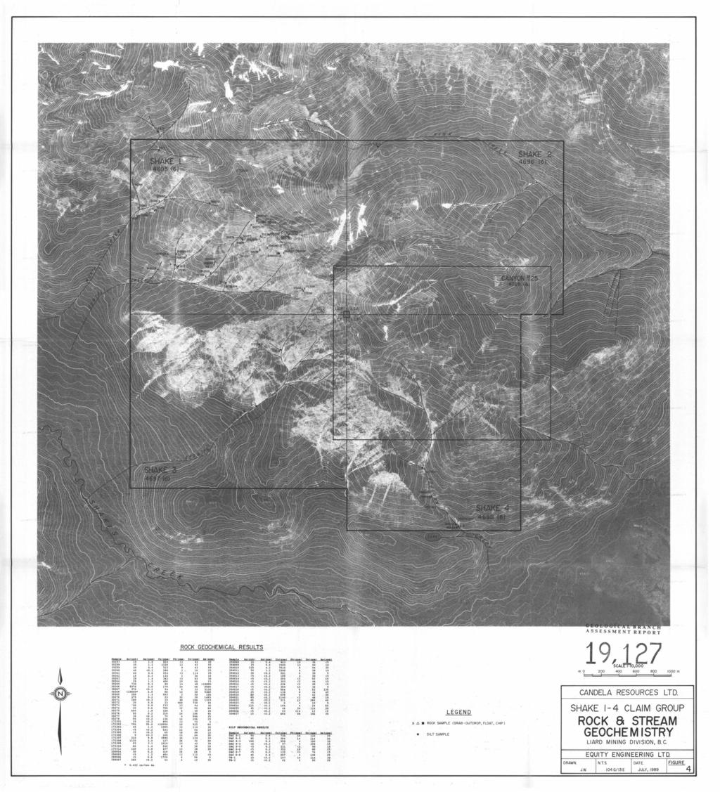
9 4 also hosted disseminated copper mineralization within syenite and the intruded volcanics (BCDM, 1966). The MH iron deposit, hosted by a pyroxenite stock on Shakes Creek seven kilometers northwest of Rugged Mountain, was also explored extensively in the 1960 s. No work has ever been recorded on the ground currently covered by the Shake 14 claims. However, claim tags dated June 18, 1971 were found immediately west of Rugged Mountain peak. The claims, staked on behalf of Amax Explorations, are part of the Horn group of claims that once covered Rugged Mountain in a northwesterly direction. The ground was undoubtably acquired by Amax for the porphyry copper potential of the syenite body on the southern flank of Rugged Mountain Work Program During June of 1989, Candela Resources Ltd. carried out reconnaissance exploration on the Shake 14 claims, consisting of geological mapping, prospecting and stream sediment sampling, using a topographic orthophoto at a scale of 1:5000. This program was targeted at goldrich mesothermal base metal veins similar to those occurring within a similar geological environment to the southeast in the Galore Creek, Iskut River, Sulphurets and Stewart mining districts. During the course of this program, silt samples and rock samples were taken. Silt samples were taken from silt accumulations in major drainages, sieved to minus 80 mesh in the laboratory and analysed geochemically for gold and 32element ICP (Figure 4). Prospecting and reconnaissance geological mapping were carried out over all claims, using a 1:5000 orthophoto with tenmeter contour intervals as a base (Figure 4). Rock samples, described in Appendix C, were taken from zones of alteration and mineralization and analysed geochemically for gold and 32element I Equity Engineenng Ltd. P *I.v>g.r
10 assayed for gold. D. Analytical certificates are attached in Appendix I 5.0 REGIONAL GEOLOGY The Telegraph Creek area lies on the western margin of the Intermontane Belt within the Stikine Arch near its contact with the Coast Plutonic Complex (Figure 3). A sequence of Paleozoic to middle Triassic oceanic sediments is unconformably overlain by Upper Triassic Stuhini Group island arc volcanics and sediments. These have been intruded by Upper Triassic to Lower Jurassic syenitic stocks and by Jurassic to Lower Cretaceous quartz diorite and granodiorite plutons of the Coast Plutonic Complex. The oldest rock assemblage in the Telegraph Creek area consists of Permian bioclastic limestone (Unit 3) overlying metamorphosed sediments and volcanics (Unit 2) and crinoidal limestone (Unit 1). Unconformably overlying the Permian limestone unit are Upper Triassic Stuhini Group island arc volcanics and sediments (Units 5 through 8). In the Telegraph Creek area, Souther (1971) grouped these volcanic and sedimentary members in Unit 9, noting however that it was composed predominantly of augite andesite breccia, conglomerate and volcanic sandstone. Several significant gold occurrences are hosted by Upper Triassic Stuhini volcanics in a cluster around Galore Creek seventy kilometers to the south. This Upper Triassic volcanosedimentary package is also correlative with that which hosts the Snip and Stonehouse gold deposits of the Iskut River district a further sixty kilometers to the south. Equity Engineering Ltd. h *I) w.*.w
11 Small, equidimensional syenite, pyroxenite and orthoclase porphyry stocks (Unit 121, dated as Late Triassic to Early Jurassic by Souther (1971), intrude mainly Stuhini volcanics. Two of these stocks outcrop on Rugged Mountain and Mount Rowgeen. The syenite porphyry associated with the Poke and Gordon copper occurrences, ten kilometers west of Rugged Mountain, may also belong to Unit 12. The Galore Creek and Copper Canyon coppergold porphyry deposits are also hosted by Upper Triassic volcanics intruded by syenitic stocks of Unit 12. Orthoclase porphyry or syenite stocks are associated with most significant precious metals deposits in the Stewart, Sulphurets and Iskut River districts, including the Silbak Premier, Sulphurets, and Snip deposits. 6 Lower Jurassic conglomerates (Unit 13) with granodiorite clasts unconformably overly Triassic sediments of the Stuhini Group. The Jurassic volcanosedimentary strata are similar in appearance to those of the underlying Stuhini Group, with differentiation possible mainly through fossil identification. Jurassic and Cretacous granodiorite to quartz diorite batholiths (Unit 17) of the Coast Plutonic Complex intrude all older lithologies. This unit consists mainly of mediumgrained hornblendebioti te granodiori te with lesser hornblende quartz diorite and is locally foliated near its margins. Coarse conglomerate, sandstone, siltstone and minor black shale of the Upper Cretaceous and Lower Tertiary Sustut Group (Unit 21) unconformably overlies Jurassic strata on Mount Helveker and are found along the Stikine River below Telegraph Creek. Conformably overlying the Sustut Group on Helveker Mountain are about 160 meters of felsic to intermediate, mainly pyroclastic rocks (Unit 24), correlated by Souther (1972) to the Early Tertiary Sloko Group found further to the northwest. Equity Engineering Ltd.t. ~..r!l.
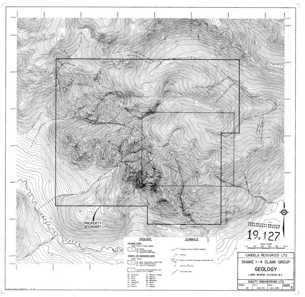
12 Equity Engineering Ltdt 2,c F Upper Tertiary and Quaternary basalt flows (Unit 25) are exposed in the Stikine River and north of Dodjatin Mountain PROPERTY GEOLOGY AND MINERALIZATION 6.1 Geology Reconnaissance geological mapping indicates that the property is underlain by volcanic and sedimentary rocks of the Upper Triassic Stuhini Group (Unit 8) that are intruded by a differentiated syenitic intrusive (Unit 12) on the southern flank of Rugged Mountain (Figure 4). The legend on the property geology map was selected in order to incorporate the divisions and numbering used on Souther s 1971 Telegraph Creek map. Volcanic members of the Stuhini Group consist of dark green, mafic volcaniclastics (Unit 8a) and minor augite porphyry flows. The volcaniclastic rocks are easily identified by the appearance of subrounded to subangular fragments on weathered surfaces. The clast size varies from a tuffaceous grit to small blocks, greater than ten centimeters across, characteristic of a volcanic breccia. The dark green color of the tuff/breccia is due to a pervasive chloritization. Exposures of this rock unit are found north of Contact Creek on the west side of the Shake 1 claim. On the south end of the claim group in Forelorn Creek, a bedded volcanic sandstone outcrops (Unit 8b). This rock is distinguished by layering one to four centimeters wide, and is very well jointed. Overlying the volcanic group is a mixed sedimentary package of laminated siltstone/greywacke, argillite and thin discontinous limestone horizons (Unit 7). The package characteristically weathers to a rusty colour, reflecting 15% pyrite content and this is exemplified by the gossans on the west side of Rugged Mountain
13 peak which are underlain by pyritic, thinly laminated, calcareous, siltstone/greywacke. Bedding measurements indicate these sediments strike northwesterly and dip in a shallow to moderate northeasterly direction. Fossil casts of pelecypod (Monotis?) can be found in argillite subcrop northwest of Rugged Mountain. This fossil would confer with the assigned Upper Triassic age of this sedimentary package. Souther (1971) has tentatively mapped Unit 7 as being conformably overlain by the volcanic rocks (unit 8); however, no bedding or structural evidence was seen to explain why the sedimentary succession is found overlying the volcaniclastic package in this area. The stratigraphic positioning exhibited on the Shake property agrees the stratigraphic section proposed by earlier government mapping by Kerr (1948). a Further west, close to the northern boundary of the Shake 1 claim is a polymictic conglomerate (unit 8c) containing siltstone, argillite, limestone, flower porphyry and volcaniclastic clasts. As the unit is fairly resistant to weathering, the conglomerate forms steep bluffs and surface weathering out of limestone clasts gives a pocked weathered surface. The clasts within this unit are well rounded and may be up ten centimeters in diameter. The intrusive rocks (Unit 12) are separated into three categories: syenite, orthoclase porphyry and pyroxenite. The first category forms the main plutonic mass in the southwest quadrant of the property whereas the second two rock types are related to the main syenite by a high content of potash feldspar and an absence of quartz. This group of alkaline intrusives cut Upper Triassic volcanic and sedimentary rocks and are dated as late Triassic to early Jurassic. The main body on Rugged Mountain is a mainly equigranular, locally porphyritic syenite (Unit 12a) consisting of orthoclase and minor mafic minerals. The colour of this unit varies from a grey Equity Engineering Ltd. t. "~uw.'~
14 9 colour to reddish pink. Kerr (1948) differentiated the two types on the basis of colour and crosscutting relationships leading him to conclude that "the red colour is due to the development, or introduction, of the unknown reddening constituents." The grey syenite is predominately on the north side of the pluton and the red syenite is more to the south and can be found cutting the grey mass. The "unknown reddening agent" proposed by Kerr is probably an alteration product of potassium feldspar introduced late in the crystallization of Rugged Mountain syenite. Dykes of the syenite material are found in the surrounding volcanic rocks near to the contact of the main mass. A rind of dark green, pyroxenite (Unit 12c) occurs on the syenitevolcanic/sedimentary contact. The pyroxenite is comprised of a high content of granular, disseminated magnetite (up to 50%), biotite and a dark green pyroxene, augite. The pyroxenite exhibits sharp contact boundaries with both the syenite and the surrounding volcanic rocks following the length of Contact Creek. The formation of the pyroxenite may be a result of the assimilation of mafic volcanic material and perhaps, by the differentiation of the main syenitic body. The pyroxenite shell on Rugged Mountain appears to be very similar to the magnetiterich described on the MH property. pyroxenite iron property located northwest of the Shake The third intrusive type (Unit 12b) is that of the orthoclase porphyry dykes (sills?) found crossing Rugged Mountain in a northeasterly di rection. These dykes are character; zed by large orthoclase phenocrysts up to several centimeters across, set within a light grey, aphanitic groundmass. The dykes are generally not greater than meters wide and contacts with the country rock are sharp.
15 c 6.2 Mineral i ration Two types of sulphide mineralization were discovered during the current exploration program: shear hosted, quartzcarbonate veining and syenite hosted veining and fracture fillings. The greatest precious metal potential exists in the veining of the first type. The strongest sulphide mineralization and best gold values were found in narrow quartzcarbonate veins and discontinuous massive sulphide lenses within shear structures in altered volcanic and sedimentary rocks north of Contact Creek. The mineralogy consists mainly of pyrite, chalcopyrite, magnetite and arsenopyrite with as well as a single occurrence of molybdenite. These zones of mineralization are easily identified by their rusty weathered surfaces of limonitic products and copper staining. Syenite and orthoclase dykes are quite often found in close proximity to these mineral occurrences. Although some of the structures are well mineralized, the majority of them are limited in both width and strike length. Typical of these structures is a narrow sheared zone with isolated pods of pyrite and chalcopyrite, sampled north of Contact Creek (Sample# ). A select grab of the sulphide pods contained 790 parts per billion gold and 55.0 parts per million silver. The highest gold values were returned from a 5 to 20 centimeter wide quartzcarbonate vein, mineralized with pyrite, arsenopyrite and chalcopyrite, that can be traced for approximately 50 meters. The vein is hosted in pyritic sediments and strikes northeasterly and dips steeply to the southeast. Sample# 30268, a grab sample from the zone, assayed ounces per ton gold. The syenite was found to contain chalcopyrite and pyrite mineralization along fractures and in veins, more typical of
16 Equity Engineering Ltd. 8, 11 porphyry style mineralization. One of the vein structures was found to be anomalous in gold with a geochemical value of 1120 parts per billion (Sample# ). The frequency and density of the mineralized structures do not appear great enough in the areas examined to host a large tonnage, porphyry style deposit. Character samples were taken of the magnetite rich pyroxenite surrounding the main syenite body (Sample# ) and weakly pyritic orthoclase porphyry dykes (Sample# ). Gold values for both rock types were below detection limit and the copper content of the pyroxenite was weakly anomalous at 533 parts per million. 7.0 STREAM GEOCHEMISTRY Ten silt samples were taken from streams draining the Shake 14 claims (figure 5). The results confirm, in part, the results of the National Reconnaissance survey released in 1988 and reflect the mineralization found north of Contact Creek in the altered volcanic and sedimentary rocks. The government survey showed the drainages on the west side of Rugged Mountain (Syenite, Contact, Forelorn, North Creeks) to be anomalous in copper, cobalt and gold. Eight of the silt samples taken this year were very anomalous in copper (up to 720 parts per million) reflecting the copper mineralization in the syenite, volcanic and sedimentary rocks on the west side of the Shake property. Four of the samples contained elevated gold values ranging from 40 to 0 parts per billion. Three of these samples were taken from northern tributaries of Contact Creek in areas underlain by altered volcanics and sediments intruded by syenite and orthoclase porphyry dykes. This area has
17 Equity Engmeenng Ltd. a. I 'Ib.r"*.V 12 been identified by mapping and prospecting to be a favourab e host for precious metal mineralization and this is being reflected in the anomalous stream geochemistry. / One sample taken (S8) on a tributary of Syenite Creek returned a gold value of 45 parts per billion. The source of this anomaly was found up slope in a narrow quartzcarbonate vein with pyrite and chalcopyrite. A grab sample of this vein, Sample# , contained 1120 parts per billion gold. 8.0 DISCUSSION AND CONCLUSIONS During the course of limited exploration work in 1989, anomalous stream sediment and rock samples were taken from the western slope of Rugged Mountain on the Shake 14 mineral claims. Rock samples collected from the property which showed notable gold and copper geochemistry were taken from a number of shear vein structures hosted in volcanic and sedimentary rocks in close proximity to a syenite intrusion and satellite orthoclase porphyry and syenite dykes. The narrow, quartzcarbonate veins contain pyrite, chalcopyrite, arsenopyrite and magnetite. To date, the best results come from a 5 to 20 centimeter wide vein with arsenopyrite mineralization. A grab sample from this vein assayed ounces per ton gold. Silt sampling on the Shake 1 claim indicated that three of the drainages contained gold values of 40, 90 and 0 parts per bi 11 ion with very anomalous copper values. anomalies remain to be discovered. The source of most of these Extremely encouraging initial results, coupled with the exploration successes achieved a1 1 along the regional trend between
18 c 13 the Stewart, Iskut River, Galore Creek and Schaft Creek areas provide abundant incentive to conduct further exploration work on the Shake 14 mineral claims. Respectfully submitted, EQUITY ENGINEERING LTD. David A. Caulfi Y d, F.G.A.C. Vancouver, British Columbia September, 1989 Equity Engrneenng Ltd., B7
19 h c APPENDIX A BIBLIOGRAPHY Equity Engineering Lg.
20 BIBLIOGRAPHY Allen, D.G., A. Panteleyev and A.T. Armstrong (1976): Galore Creek, in CIM Special Volume 15, pp BCDM (196366): Annual Report; British Columbia Department of Mines. Forster, D.B. (1988): Summary Report, Shake 14 Claims; private report for Continental Gold Corp. Fox, P.E., E.W. Grove, R.H. Seraphim and A. Sutherland Brown (1976): Schaft Creek, in CIM Special Volume 15, pp Folk, P. (1981): Geochemical Report on the Limp #2 Claim; British Columbia Ministry of Energy, Mines and Petroleum Resources Assessment Report Geological Survey of Canada (1988): National Geochemical Reconnaissance, Sumdum Telegraph Creek, British Columbia (NTS 4F 4G); GSC Open File Kerr, F.A. (1948): Lower Stikine and Western Iskut River Areas; Geological Survey Memoir 246. Souther, J.D. (1972): Telegraph Creek Map Area, British Columbia; Geological Survey of Canada Paper Equity Engineering Ltd. h
21 t Equity Engineering Ltd. h.,." APPENDIX B STATEMENT OF EXPENDITURES
22 STATEMENT OF EXPENDITURES SHAKE 14 CLAIMS (June 1623, 1989) PROFESSIONAL FEES AND WAGES: David A. Caulfield, Geologist 7.75 days 8 $350/day Henry J. Awmack, P.Eng. 0.5 days 8 $350/day Kika Ross, Geologist 2.5 $250/day Tom Bell, Prospector 6.5 days 8) $250/day Don Coolidge, Prospector 6.0 days 8 $250/day Cl er i cal 12 hours 8 $20/hour EQUIPMENT RENTALS: Truck 3.5 days 8 $60/day Truck (Standby) 3.0 days Q $/day Handheld Radios days 8 $5/day Fly Camp 21 mandays 8 $20/manday CHEMICAL ANALYSES: $13.87 rock geochem 63 $ gold assay 6L $8.46 EXPENSES : Materials and Supplies Maps and Publications Orthophoto Construction Printing and Reproductions Camp Food Camp Fuel Camp Supplies Meals Travel Automotive Fuel Aircraft Charters Helicopter Charters Telephone Distance Charges Freight Expediting Courier and Telefax $ 2, , , $ $ 1, $ , , $ 6, , , Equity Engineering Lth. I
23 t REPORT (estimated) MANAGEMENT FEE: 15% on expenses 2, Equity Engineering La. 1
24 APPENDIX C ROCK DESCRIPTIONS

25 EQUkI Y ENGINEERING LTD. Geochemical Data Sheet ROCK SAMPLING Project c PPW 02 Property Shakes 14 NTS /044//?~ Location Ref R4 ed M&. Air Photo No PRINTED IN CANADA
26 EQUITY ENGINEERING LTD. Geochemical Data Sheet ROCK SAMPLING Project LDD 840s Property 5kh6 14 AS
27 EQUIT. ENGINEERING LTD. Geochemical Data Shtet STREAM SILTS NTS,b44/ /3& Project cvv sq02 Location Ref p99d Property 5 ffuxe5 /4 Air Photo No

28 EQUITY ENGINEERING LTD. Geochemical Data Sheet ROCK SAMPLING Property Ghskes 14 NTS Location Ref Air Photo No /0+4//3E Ra5 9 cd Yfh
29 CQUI 1 Y ENGINEERING LTD. Sampler?# COO lid4 c Date functt, r?@f Geochemical Data Sheet ROCK SAMPLING Project Property Shakes 14 L D p 890 Z NTS t /04k//fP Location Ref K'ypf Air Photo No. PRINTED IN CANADA

30 EQUITY ENGINEERING LTD. Geochemical Data Sheet ROCK SAMPLING Project CDD BpoP Property shakes /4 NTS /044//3E cd 4% Location Ref Z~CS Air Photo No ASSAYS PRINTED IN CANADA
31 APPENDIX D CERTIFICATES OF ANALYSIS Equity Engineering Ltd.
32 ' Chemex Labs Ltd. To: EQUITY ENGINEERING LTD. Anaiytlcai Chemists * Geochemlsts * Reglstered Assayers W. HASTINGS ST. 112 BROOKSBANK AVE., NORTH VANCOUVER, VANCOUVER, BC BRITISH COLlMBIA. CANADA V7JICI V6B IN2 PHONE (604) I CERTIFICATE A I EQUITY ENGINEERING LTD. PROJECT : CDD8901 P O X : NONE Samples submitted to our lab in Vancouver, BC. This report was printed on 9JUL89. I 1 CHEMEX MMBER OODE SAMPLE PREPARATION ISAtvlPLESI DESCR I PT I ON 5 7 Rock Geochem: Crush,split,rins 5 7 ICP: Aqua re& digestion NulE I: The 32 element ICP package is suitable for trace metals in soil and rock samples. Elements for which the nitricaqua regia digestion is possibly incomplete are: Al, Ba. Be, Ca, Cr, Ga, IC, La, hfg, Na, Sr, Ti, TI. W. t I I lsrlq DES Comncnts: ATTN: D. CAULFIELD I ANALYTICAL PROCEDURES I PT ION Ti %: 32 element, soil & rock TI ppm: 32 element. soil & rock U ppm: 32 element, roil & rock V ppm: 32 element, soil & rock W ppm: 32 element, soil & rock Zn ppm: 32 element, soil & rock METHOD FAAAS I C P A E S DETECT ION LIMIT I I I 0.01 LO I I I 0.01 LO I 2 A I oo I oo l I I I LIMIT I i j

33 ~~ ~ Chemex Labs Ltd. Anaiytlcal Chemlsts * Geoctsemlsts Registered Assayers 312 BROOKSBANK AVE., NORTH VANCOUVER, BRITISH COLLMBIA, CANADA V7JZCI PHONE (604) TO : EQUITY ENGINEERING LTD W. HASTINGS ST. VANCOWER, BC V6B IN2 Project : 89Of Conments: ATTN: D CAULFIELD Page No. : IA Tot. Pages: 2 Date : 9JUL a9 Invoice #:I P.O. fi :"E I CERTIFICATE OF ANALYSIS A t SWLE DESCR I PTI ON E E E E E E E E E E E E E E E E E E E E E I72301 H I72302 H H I72304 H H H H I72308 H H I723 H H H H H H H PREP CODE 20 5 I 38 I38 I38 I a t 231 ku ppb Al As A8 Ba Be Bi C a C d C o C r C X I F e G a H g FkMA w Ppn PPn Ppn Ppn Ppn % Ppn PPn PPn PPn % Ppn Ppn % PPn IS <0.5 <2 1.46< I I 0.09 LO < < < <0.5 < < I < LO <0.5 4 >15.00 <o.s 18 < I < I 0.02 < <0.5 < < < < ~ ~ ~ ~ I < LO CO < < I <0.01 < LO < < LO IS < <O I 0.06 LO >loo00 < LO <0.5 < < < LO <0.5 < 2.90 < < < I 0.15 < < < < , 2.95 < < >loo < LO 0.5 < < < < < <0.5 I07 I LO >15.00 < LO < < >IS 00 < IS 1. < LO < I 0.15 < ~ ^ C I < 1.0 < 2 0 LO <O.J 2s , 5.20 < I 0.04 < LO < < I LO 1.5 < <O.S 18 II I < LO 2.0 < , 8.29 < < < <0.2 2s LO <0.5 < I 0.12 < 1.78 I <0.2 IS <0.5 < < I < <0.5 < < , 6.17 < I <o.s < IS >loo <O.S < <O.S , 8.51 < < _ < <O.S < <O.S I 0.26 < 1.41 < < <O.S < <O.S < < I < <0.5 < < <O.S < < I <0.5 < <O.S 8 8 I < < I 0.29 < <O.S < <0.5 IS 144 X5.00 I 0.23 < <0.5 <2 0.33< < <0.5 <2 0.36<0.5 I I <0.5 < < SO < < 5 70 < < < I < <0.5 <2 2.00< I c < I 0 <O.S < < < < 5 <0.5 < < < < < CO.5 < < l58j 7.23 < < I <0.5 C < C < C CERTlPlCATlON :
34 _I_ I ~ ~~ ~~~~ Chemex Labs Ltd. Analytlcal Chemlsts * Geochemlsts * Reglstered Assayers 2 I2 BROOKSBANK AVE, NORTH VANCDLWER, BRlTlSH COLtMBIA, CANADA V7J2CI PHONE (604) TO : EQUITY ENGINEERING LlD W. HASTINGS ST. VANCOWER, BC V6B IN2 ProJecI : ux,8902 C111s: ATTN: D CAULFIELD Page No. : IB Tot. Pages:2 Date : 9JUL89 Invoice # :I P.O. 11 :"E I CERTIFICATE OF ANALYSIS A E E E E E E E E E E E E E E E E E E E E E E I72301 H I72302 H I72303 H ~ H I72305 H r H H I, H H 1723 H H H H H H H 3580 H._ h6 Na Ni P Pb Sb Sc Sr Ti T1 U V w z n Ppm %I Ppn Ppn Ppn Ppn Ppn Ppn 96 Ppn Ppm Ppn P P Ppll I < 2 < LO I LO LO < LO < 5 I 1195 < < I I330 < < LO < 147 < LO 114 II ( , I120 < 2 < 5 LO I < 62, I < LO < LO I I5 9 I LO LO. 7 :: < LO < 1 < LO 66, < I LO LO 131 < 32 I LO I02 LO < < I05 LO 50 I I0 30. < I < < < 17 < 6 ~. ~.. _. < I < I2 5 < I 0.01 < LO I470 < 2 < 5 I LO I080 6, 5 4 I < < < LO 6 < 186, _. ~~...~ LO < LO 161 LO 6' (2: < LO LO I5 7 5 I LO LO < I260 < 2 < < LO < 133 < 114'.. ~. < LO 6420 I < : < 5 1 I < 2, < LO 84 < I LO < < LO < 97 < 32 I._ LO < LO I < I72 < < LO 209 < 66 >loo I6 960 < 2 5 II < LO < _. ~ ~ I < LO < 255 lo < I40 6 < <0.01 < < LO 37 < I < LO < LO 0 < 36 I , < < LO < LO I07 < < LO < I ~_..._
35 SMLE DESCRIPTION PREP m E Chemex Labs Ltd. Analytlcal Chemlsts * Geochemlsts * Reglstered Assayors BROOKSBANK AVE, NORTH VANCOUVER, BRITISH COLlMBIA. CANADA V7J2CI PHONE (604) To EQUITY ENGINEERING LTD W. HASTINGS ST. VANCOUVER, BC V6B IN2 PrOJOCt : 8902 Comnents: ATTN: D CAULFIELD Page No. :2A Tot. Pages2 Date : 9JUL89 Invoice # :I P.O. # :"E 1 CERTIFICATE OF ANALYSIS A AU ppb Al As As Ba Be Bi Ca Cd Co Cr C h Fc Ga is K L a h. h l k h FMA.4 % P P P P PPn P P P P % P P P P P P P P % P P P P 5% P P 56 PPn H H H H H H H H H H H H H H H H H.._ I I5 20 < < I 0.12 < ( 20 l.51< <0.5 < <0.5 I : < <0.2 < 5 20 <0.5 < ( LO I 0.06 LO : (0.2 I5 30 <0.5 < <0.5 I < I 0. LO ( < < <0.5 < <0.5 I LO < I 0.12 < : < 5 c5 < ~ < _.. < 5 I5._ I I co.2 < 5 20 <0.5 < < < < < I < < < < <0.2 < 5 < <0.5 < < < 2 < 2 < 2 <2 < I < < >15.00 < < s < 0.5 < 0.5 I9 36 I " >I 5.OO < LO X : 2 3 < ( < LO 0.40 LO % <O < ( 1140 >IS.OO 311 > < < < < LO < < < < lo < 0.44 IS( ( ( : ( ~ 8 >15.OO < I ( < >15.00 < < I 0 02 < ( CERTlPlCATlON :
36 I SAMPLE DESCRIPTION PREP m E Chemex Labs Ltd. Analytloal Chemlsls * Geochemists * Reglstered Assayers 21 2 BROOKSBANK AVE, NORTH VANCOUVER, BRITISH COLIMBIA, CANADA V7JICI PHONE (604) TO : EQUITY ENGINEERING LTD W. HASTINGS ST. VAN<xIwER, BC V6B IN2 Project : 8902 Cnts: ATTN: D CAVLFIELD Page No. :2B Tot. Pages: 2 Date : 9JUL 89 Invoice #:I P.O. # :"E CERTIFICATE OF ANALYSIS A & Na Ni P Pb Sb Sc Sr Ti TI U V w z n P P % P P P P Ppn Ppn Ppn P P % Ppn Ppn Ppn P P Ppn H H H H H H H H H H H H H H H H H. 05 i 0s zi < < < < < c C I C I < 2 5 S < < I27 < 44.. I <2' c < < < I I ' I I < < 191 < I230 8 < 5 8 SO 0.18 < I25 LO 24. I7 < C LO < 61 < 42 ~ I _ < LO 56 LO < I LO 49 < LO 280' 1 c 0.01 < < I 725 <O.Ol < < I I LO < < I4 0. < C I31 < LO 124' * ~. ~ ^ c I <0.01 c I I145 <0.01 C < 3 < ' < ' I...
37 Chemex Labs Ltd. Analytlcal Chemlsts * Goochemlsts * Roglsterod Assayors To: EQUITY ENGINEERING LTD W. HASTINGS ST. 211 BROOKSBANK AVE., NORTH VANCOUVER, VANCOUVER, BC BRITISH COLIMBIA. CANADA V7J2CI V6B IN2 PHONE (604) CERTIFICATE A EQU 1 TY ENG I NEER I NO LTD. PROJECT : CDDIP02 p o l l : NONE Samples submitted to our lab in Vancouver, BC. This report was printed on 9JUL89. t NOTE I : SAMPLE PREPARATION DESCR I PT I ON Dry, sieve 80 mesh; soil. sed. [CP: Aqua regia digestion The 32 elemen ICP package is suitable for trace metals in soil and rock samples. Elements for which the nitricaqua reoia digestion is possibly incomplete are: Al, Ba, Be. Ca, Cr. Ga, K, La, Mg, Na, Sr, Ti, TI, W. J1EMEx CODE I ANALYTICAL PROCEDURES I LO LO LO LO LO LO LO LO LO DETECT I ON DESCRIPTION METHOD LIMIT. Au ppb: Fuse LO 8 sample A1 A: 32 element, soil & rock Ag ppm: 32 element, soil & rock As ppm: 32 element, soil & rock Ba ppm: 32 element, soil & rock Be ppm: 32 element, soil & rock Bi ppm: 32 element. soil & rock Ca %: 32 element, soil & rock Cd ppm: 32 element, soil & rock Co ppm: 32 element, soil & rock Cr ppm: 32 element, soil & rock Cu ppm: 32 element, soil & rock Fe %: 32 element. soil & rock Ga ppm: 32 element, soil & rock Hg ppm: 32 element, soil & rock K %: 32 element, soil & roct La ppm: 32 element, soil & rock Mg %: 32 element, soil & rock Mn ppm: 32 element, #oil & rock Mo ppm: 32 element, soil & rock Na 5%: 32 element, soil & rock Ni ppm: 32 element, soil & rock P ppm: 32 element, roil & rock Pb ppm: 32 element, soil & rock Sb ppm: 32 element, soil & rock Sc ppm: 32 elements, soil & rock Sr ppm: 32 element, soil & rock Ti 48: 32 element, soil & rock TI ppm: 32 element, soil & rock U ppm: 32 element, soil & rock V ppm: 32 element, soil & rock W ppm: 32 element, soil & rock Zn pprn: 32 element. soil & rock FAAAS I C P A E S I C P A E S I C P A E S I C P A E S I C P A E S I C P A E S I C P A E S I C P A E S LO LO 1 2 A IIPPER LIMIT oo oo oo oo oo
38 Chernex Labs Ltd. Analytical Chemists * Geochemists * Registered Asaayers 2 I1 BRCWKSBANK AVE, NORTH VANCXXWER. BRITISH COLIMBIA, CANADA V7JICI PHONE (604) TO : EQUITY ENGINEERING LTD W. HASTINGS ST. VANCOWER, BC V6B IN2 Project : UlD8902 Caumenls: ATTN: D CAULFFEEU, Page No. : 1A Tot. Pages:l Date : 9JUL89 Invoice Lf :I P.O. # :"E CERTIFICATE OF ANALYSIS A I S6 s7 S8 I 2 PREP Au ppb A1 A8 As Ba Be Bi Ca Cd Co Cr Cu Fe Ga Is K L a h f g h XIDE FkMA 56 PPn PP PPn PPn PPn w PPn PPn PPn PPn 96 PPn PPn % PPn % PPn < LO < C ( < < ( < C I : 38 C <o <2 1.72< < < I 0.06 < : 38 < < < I Ion. 38 < < < LO I 0. < lo ( 3% C < 2 4. < I I 0.40 LO <2 6.24< LO < : 38 I < <2 1. < I < LO < ( 38 C < < < C < LO ( CERTlPlCATION :
39 Chemex Labs Ltd. Analytlcal Chemlsts * Geochemlsts * Reglstered Assayers 212 BRWKSBANK AVE.. NORTH VANCOINER, BRITISH COLlMBIA, CANADA V7J2CI PHONE (604) TO : EQUITY ENGINEERING LTD W. HASTINGS ST. VANCOUVER. BC V6B IN2 Projecl : UX>8902 Cnls: ATTN: D. CAULFIELD Page No. : IB Tot. Date Pages:l : 9JUL89 Invoice # :I P.O. # :"E I CERTIFICATE OF ANALYSIS A SWLE IESCR I PTI nc si nc s2 b c s3 nc s4 nc s5 HC S6 nc s7 nc s8 B I B2 PREP CQDE LO I LO I LO I LO I LO I 1 LO I I LO 1 LO I hk Na Ni P Pb Sb Sc Sr Ti TI U V w z p Ppn % Ppm P P Ppn P P Ppn P P 96 Ppn Ppn Ppn PP PP I5 lo I200 I IS I < 5 19 I < < c c I4 C 5 I c5 II < LO c < c LO < LO c c < < LO c LO < < c c < < 169 < I0 380 C 282 LO 239 < 438 c LO I88 c I42 < I22 I I I38 I I4 90. CERTIFICATION : 1
40 ~ ~ To: EQUITY ENGINEERING LTD. Chemlsts Geochemists Labs * Registered Assayers Ltd W. HASTINGS ST. 1 I2 BROOKSBAMC AVE, NORTH VANCOUVER, VANCOUVER, BC BRITISH COLCMBIA, CANADA V IJZCI V6B IN2 Chemex Analytlcal PHONE 1604) Comne n I 8 : ATTN : 0, CAllLF I ELD A CERTIFICATE A L J EQU I TY ENG I NEER I NO LID PROJECT : CVD8902 P O # : NONE Samples submitted to our lab in Vancouver, BC. This report was printed on 17JUL89. MEN COD ANALYTICAL ~I ~.. PROCEDURES DETECT I ON UPPER DESCR I PT I ON METHOD LIMIT LIMIT ku ozlt 112 assay ton FAGRAVIMETRIC , SAMPLE PREPARATION..... I 1 DESCRIPTION...
41 Chemex Labs Ltd. Analytical Chemists * Geochemlsts Realstered Aesayers 211 BROOKSBANK AVE, NORTH VANCOUVER, BRITISH a)l.tmbia, CANADA V7J2CI PHONE (604) TO : EQUITY ENGINEERING LlD W. HASTINGS ST. VANCOWER, BC V6B IN2 Project : Comments: ATTN: D. CAULPIED Page No. : I Tot. Pages:l Date : 17JUL89 Invoice ti : P.O. # :"E I CERTIFICATE OF ANALYSIS A SAMPLE DESCRIPTION E PREP CODE 214 iu FA )z /T P, CERTIFICATION : 'ac. CERTIFIED ASSAYER
42 APPENDIX E' STATEMENT OF QUALIFICATIONS Equity Engineering Ld.
43 STATEMENT OF QUALIFICATIONS I, DAVID A. CAULFIELD, of 3142 Gambier Street, Coquitlam, in the Province of British Columbia, DO HEREBY CERTIFY: 1. THAT I am a Consulting Geologiet with offices at Suite 207, 6 15 West Hastings Street, Vancouver, British Columbia THAT I am a graduate of the University of British Columbia with a Bachelor of Science degree in Geology. THAT my primary employment since 1978 has been in the field of mineral exploration THAT my experience has encompassed a wide range of geological environments and has a1 lowed considerable familiarization with geophysical, geochemical, and diamond drilling techniques. THAT I am a Fellow, in good standing of the Geological Association of Canada. THAT this report is based on fieldwork carried out under my direct supervision from June 16 through June 23, 1989 and on government publications and assessment reports filed with the Province of British Columbia. DATED at Vancouver, British Columbia, this %<day of September, David A. Caulfikld, F.G.A.C. Equity Engineering LtQ?
44
45
Serengeti Resources Inc GEOCHEMICAL REPORT ON THE SHADOW PROPERTY a.
 Serengeti Resources Inc. 2004 GEOCHEMICAL REPORT ON THE SHADOW PROPERTY a. Located in the Johanson Lake Area Omenica Mining Division NTS 94D/9 6 degrees and 32 minutes North Latitude 126 degrees and 2
The Cobalt Rainbow. Airborne geophysical maps show that a north trending aeromagnetic high suggests further undiscovered mineralisation.
 The Cobalt Rainbow The property is located on Greenstone Creek, approximately 4.8 kilometres south west of the creek mouth. The property is located about 24 km due west of Campbell River, in the east-central
GEOLOGICAL MAPPING REPORT ON THE ASH MINERAL CLAIM OSOYOOS MINING DIVISION ASHNOLA RIVER MAP SHEET NTS M092,H019 MCBRIDE CREEK AREA, ASHNOLA RIVER,
 GEOLOGICAL MAPPING REPORT ON THE ASH MINERAL CLAIM OSOYOOS MINING DIVISION ASHNOLA RIVER MAP SHEET NTS M092,H019 LATITUDE 49 o O6, LONGITUDE 120 o 22 MCBRIDE CREEK AREA, ASHNOLA RIVER, KEREMEOS, B.C. CANADA
ASSESSMENT REPORT ON THE PEAVINE PROJECT. DGW & Associates # Alberni Street, Vancouver, British Columbia, V6E 4V2
 ASSESSMENT REPORT ON THE PEAVINE PROJECT KAMLOOPS MINING DIVISION BRITISH COLUMBIA NTS 082M 12 Latitude 51 36' 19.0"North -- Longitude --119 47' 27.0"West UTM Zone 11, NAD 83 5720827N 306744E Prepared
2013 GEOLOGICAL ASSESSMENT REPORT SHERIDAN HILL PROPERTY
 2013 GEOLOGICAL ASSESSMENT REPORT ON THE SHERIDAN HILL PROPERTY NEW WESTMINSTER MINING DIVISION BRITISH COLUMBIA NTS 092G07 49 16 31 NORTH LATITUDE, 122 39 48 WEST LONGITUDE PREPARED FOR Sheridan Hill
PROSPECTORS ASSISTANCE PROGRAM MINISTRY OF ENERGY AND MINES
 BRITISH COLUMBIA PROSPECTORS ASSISTANCE PROGRAM MINISTRY OF ENERGY AND MINES GEOLOGICAL SURVEY BRANCH PROGRAM YEAR: 1999/2000 REPORT #: PAP 99-l 6 NAME: KIM ANSCHETZ PROSPECTORS TlEPORT on the 99 LOUIS
PRECIOUS METALS. owner. JMT Services Corp. GEOCHPlICAL SAMPLING CHELASLIE WCE, NORTH CENTRAL, B.C. OMINECA MINING DIVISION NTS 93F/5E & 6W
 PRECIOUS METALS REPORT ON 1980 RECONNAISSANCE GEOCHPlICAL SAMPLING CHELASLIE WCE, NORTH CENTRAL, B.C. OMINECA MINING DIVISION NTS 93F/5E & 6W LATITUDE 53O28 N LONGITUDE 125O31 W DATES Qp WORK: JULY 10
GEOLOGY OF THE NICOLA GROUP BETWEEN MISSEZULA LAKE AND ALLISON LAKE
 GEOLOGY OF THE NICOLA GROUP BETWEEN MISSEZULA LAKE AND ALLISON LAKE (92H/15E. 10E1 By V. A. Preto INTRODUCTION Mapping was continued southward from the area covered in 1973 and an additional 55 square
Structural Analysis Using Hillshade Imagery. on the. LLC Property
 Structural Analysis Using Hillshade Imagery on the LLC Property Liard Mining Division NTS 104F/16W Latitude: 57 53' 47'' N Longitude: 132 03' 06'' W Owner Garry John Payie 3714 Raymond Street South, Victoria,
for the Greenwood Mining Division, B.C. NTS 82E/7W 29' W, Longitude 118' 53' N Prepared by D. Dylan Watt, B.Sc.
 for the FltE NO: u VOLT 1, VOLT 2, VOLT 3, & VOLT 4 CLAIMS Greenwood Mining Division, B.C. NTS 82E/7W Latitude 49' 29' W, Longitude 118' 53' N Prepared by D. Dylan Watt, B.Sc. #309-1996 Trutch Street Vancouver,
UNION MINIERE EXPLORATIONS AND MINING CORPORATION LIMITED ASSESSMENT REPORT ON FITINAT MINERAL CLAIM. Alberni Mining Division Record No.
 M F )( UNION MINIERE EXPLORATIONS AND MINING CORPORATION LIMITED Suite 200, 4299 Canada Way, Burnaby, B.C. V5G 1 H4 Telephone (604) 437-9491 ASSESSMENT REPORT ON GEOCHEMICAL SOIL SURVEYS AND ROCKSAMPLING
for the Greenwood Mining Division, B.C. NTS 82E/7W Latitude 49' 27' W, Longitude 118' 5 Prepared by a= D. Dylan Watt, B.Sc.
 t. b LOGnO: 37~ -08 m. ACTIO#: for the AMP AMP 2 AMP 3 t AMP 4 CLAIMS Greenwood Mining Division, B.C. NTS 82E/7W Latitude 49' 27' W, Longitude 8' 5 %E c,w zc *& a w Prepared by a= -4c. D. Dylan Watt, B.Sc.
490 20' 30" North Latitude ' 30" West Longitude
 _._.. I CONSULTING GEOLOGISTS 605-602 WEST HASTINGS STREET, VANCOUVER, B.C. V6B 1P2 TELEPHONE: (604) 689-5533 6 I F: ASSESSMENT REPORT ON THE PATSY 1 MINERAL CLAIM ' '?%2% I WHISTLE CREEK, HEDLEY ARE L-l-
Prospecting Report 'S Office i DB Property, B.C. -J Negro Creek Nelson Mining District NTS 82F.050. Operator: Kootenay Gold Inc.
 . '.' I"' i9 12 Prospecting Report 'S Office i DB Property, B.C. -J Negro Creek Nelson Mining District NTS 82F.050 Operator: Kootenay Gold Inc. Owner: Darlene Lavoie Work Performed Summer of 2007 Report
003Y30RN W
 W ENGINEER CLAIMS REPORT ON PRELIMINARY GEOLOGICAL MAPPING AND GEOCHEMICAL SAMPLING ENGINEER 1,2,3, dt 4 CLAIMS LILLOOET MINING DIVISION NTS MAP SHEET 92511 E - ; 003Y30RN 123001 15 W I AND PETROLEUM RESOURCES
M.R.# _..._ $._. ' VANCOUVER, R.C
 COMINCO LTD. EXPLORATION NTS: 0G/ WESTERN CANADA 0 November ASSESSEMENT REPORT GEOCHEMICAL SURVEY ON THE SADDLEHORN PROPERTY LIARD MINING DIVISION BRITISH COLUMBIA M.R.# _....._ $._. ' VANCOUVER, R.C I
Lat. 52' 43' N Long ' W
 &A exploration ltd MINING ENGINEERING GEOLOGY- GEOPHYSICS 4570 HOSKINS ROAD, NORTH VANCOUVER, 6. C. TELEPHONE (804) 985,7921 V7K 2R1 GEOLOGICAL AND GEOCHEMICAL REPORT on the BLUE CLAIMS Cariboo Mining
1 FILMED 1. FILE NO:!..rsrru -* -. GRAND TWO CLAIM
 FILE NO:!..rsrru -* -. GRAND TWO CLAIM REPORT ON 1993 ASSESSMENT WORK GRAND TWO CLAIM REC. NO. 301849 NELSON MINING DIVISION NTS MAP SHEET 82F6/W 49 25'51" NORTH 117 18'08" WEST 1 FILMED 1 AUTHOR: R. Jordan,
A PRELIMINARY REPORT ON THE ZYMOST2 CLAIM GROtP, TERRACE, B.C.
 NATIVE EXPLORATIONS LTD. A PRELIMINARY REPORT ON THE ZYMOST2 CLAIM GROtP, TERRACE, B.C. INTRODUCTION': The Zymoetz claim group is, at present, held under option by Native Explorations Ltd.. On the 19th
REPORT. on the. Omineca Mining Division, British Columbia. Latitude N., Longitude W. NTS map sheet 93F/7E. James W. McLeod, P.Geo.
 REPORT on the CHU MOLYBDENUM PROPERTY Omineca Mining Division, British Columbia Latitude 53 21 N., Longitude 124 37 W. NTS map sheet 93F/7E James W. McLeod, P.Geo. on behalf of Mr. Chris Delorme TABLE
SOIL GEOCHEMISTRY. OK-ll AND OK-Ill MINERAL CLAIMS MOUNT THOEN AREA OMINECA MINING DIVISION, B.C. NTS 93 MI6 E & 7 W
 SOIL GEOCHEMISTRY OK-ll AND OK-Ill MINERAL CLAIMS MOUNT THOEN AREA OMINECA MINING DIVISION, B.C. NTS 93 MI6 E & 7 W LATITUDE 55O23'N, LONGITUDE 127 01W Locke B. Goldsmith, P.Eng. Consulting Geologist December
SAMPLING REPORT PINE CLAIMS. Liard Mining Division E. Owner D.C.Rotherham. Author 0.C.Rotherham P.Eng. September
 , SAMPLING REPORT PINE CLAIMS Liard Mining Division 93 0 10E Lat 55 30' N Long 122 37' W '! Owner DCRotherham Author 0CRotherham PEng September 28 1990 GEOLOGICAL BRANCH ASSESSMENT REPORT B 72 TABLE of
ASSESSMENT REPORT GEOLOGICAL BRANCH. 50' 23 'North. GEOLOGICAL and GEOCHEMICAL SURVEYS ON THE. PUTNAM PROPERTY (Putnam Mineral Claim)
") GEOLOGICAL and GEOCHEMICAL SURVEYS ON THE PUTNAM PROPERTY (Putnam Mineral Claim) VERNON MINING DIVISION, B.C. GEOLOGICAL BRANCH ASSESSMENT REPORT NTS : Latitude: 82L17W 50' 23 'North LOCATION, ACCESS,
GEOLOGICAL and GEOCHEMICAL SURVEYS ON THE PUTNAM PROPERTY (Putnam Mineral Claim) VERNON MINING DIVISION, B.C. GEOLOGICAL BRANCH ASSESSMENT REPORT NTS : Latitude: 82L17W 50' 23 'North LOCATION, ACCESS,
GEOLOGY AND LITHOGEOCHEMISTRY OF THE CHILKO-TASEKO LAKES AREA* BY G.
 B Ministry of Energy, Mines and Petroleum Resources GEOLOGICAL BRANCH MINERAL RESOURCES DIVISION NOTES TO ACCOMPANY OPEN FILE - GEOLOGY AND LITHOGEOCHEMISTRY OF THE CHILKO-TASEKO LAKES AREA* BY G. P. McLAREN
NTS 082F03SW N W U E N
 Prospecting Report JOCELYN CLAIM NTS 082F03SW N49 09 51 W 117 14 04 11U 482906E 5445737N NELSON MINING DIVISION Martin Ross PO Box 323 Salmo BC V0G 1Z0 Jan 31, 2012 PROSPECTING REPORT JOCELYN MINERAL CLAIM
GEOCHEMICAL AND PROSPECTING REPORT. RC ly 2,3,4 CLAIMS
 p- ON GEOLOGlCAL SURVEY BRANCH ASSESSMENT REPORTS - DATE RECFl'dFD AFR 0 1 19% GEOCHEMICAL AND PROSPECTING REPORT THE RC ly 2,3,4 CLAIMS IARD MINING DIVISION BRIT1 S H COLUMBIA 94E/EI W LATITUDE 57" 48'
ASSESSMENT REPORT PROSPECTING PROGRAM ION/DIRTY JACK PROPERTY NELSON MINING DIVISION N.T.S. MAP SHEET 82F.023 UTM COORDINATES N E
 ASSESSMENT REPORT PROSPECTING PROGRAM ION/DIRTY JACK PROPERTY NELSON MINING DIVISION N.T.S. MAP SHEET 82F.023 UTM COORDINATES 5454800N - 0455235E Work Performed Summer 2007 OWNER >* ' Tom Kennedy >8 404-22
twd$ yqsi+hca
 -t@~cl--t,i twd$ yqsi+hca C ASSESSMENT REPORT ON THE OR0 1-5 CLAIMS NEAR GOLDBRIDGE, B.C. Lillooet Mining Division N.T.S. 92 J / 15 W Long. 122 51.5 W. Lat. 50 47.5 N. Owned by Levon Resources Ltd. Optioned
GOLDCLIFF TULAMEEN PORPHYRY COPPER PROJECT COPPER MOUNTAIN CAMP, BRITISH COLUMBIA THE TROJAN-CONDOR COPPER TARGET HIGHLIGHTS
 Suite 350-885 Dunsmuir Street PF 250 764 8879 TF 866 769 4802 Vancouver, BC, Canada FX604 261 8994 info@goldcliff.com V6C 1N5 GCN.TSXV www.goldcliff.com GOLDCLIFF TULAMEEN PORPHYRY COPPER PROJECT COPPER
Beekeeper Property The Geology South of Mint Lake. Cariboo Mining Division
 Beekeeper Property The Geology South of Mint Lake NTS: 93A/6 Cariboo Mining Division Claims: Beekeeper 1 #I2055 Beekeeper 2 #3892 Beekeeper 3 #7895 Beekeeper 4 #8503 Latitude: Longitude: 52 degrees 24
PROSPECTING REPORT. Medallion Property. EVENT # TENURE # Tenure Name: GPEX CLVIII Medallion
 2006-2007 PROSPECTING REPORT Medallion Property EVENT # 4167980 TENURE # 540362 Tenure Name: GPEX CLVIII Medallion Watson Bar Region Clinton Mining Division Map 092O Central Coordinate Reference Long.
R.A. COMINCO LTD. EXPLORATION NTS: 92H/16. WESTERN DISTRICT January 6, 1982 ASSESSMENT REPORT 1981 SOIL GEOCHEMISTRY ON THE TROUT PROPERTY
 COMINCO LTD. EXPLORATION NTS: 92H/16 WESTERN DISTRICT January 6, 1982 ASSESSMENT REPORT 1981 SOIL GEOCHEMISTRY ON THE TROUT PROPERTY (Trout 1 and 6 Claims) SIWASH LAKE AREA, SIMILKAMEEN M.D., B.C. (Work
The MAPLE BAY PROJECT Copper Silver - Gold
 The MAPLE BAY PROJECT Copper Silver - Gold Good grade and tonnage potential within close proximity to Tidewater The Maple Bay Copper Silver Gold Project covers highly favourable geological host rocks of
Daiwan Engineering Ltd Granville strees V.ncouver, B. C. cuudr WY 1GS. M e : (604) PROSPECTING REPORT ON THE KING MINERAL CLAIMS
 PROSPECTING REPORT ON THE KING MINERAL CLAIMS") 1030-609 Granville strees V.ncouver, B. C. cuudr WY 1GS M e : (604) 688-1508 PROSPECTING REPORT ON THE KING MINERAL CLAIMS NORTH VANCOUVER ISLAND, BRITISH COLUMBIA NTS: 92Lj13E Latitude: 50" 47' Longitude:
1030-609 Granville strees V.ncouver, B. C. cuudr WY 1GS M e : (604) 688-1508 PROSPECTING REPORT ON THE KING MINERAL CLAIMS NORTH VANCOUVER ISLAND, BRITISH COLUMBIA NTS: 92Lj13E Latitude: 50" 47' Longitude:
NEW HAZELTON, OMINECA M.D.,
 PROSPECTING REPORT JUDI 1 TO 6 MINERAL CLAIMS NEW HAZELTON, OMINECA M.D., B.C. MAP 93M/4E, LAT. SS014'N, LONG. 127'33'W OWNED BY: A. L'ORSA ANTHONY L'ORSA Smithers, B.C. 21 February, 1981 TABLE OF CONTENTS
ARGENTINE FRONTIER RESOURCES INC (AFRI) SALTA EXPLORACIONES SA (SESA)
 SALTA EXPLORACIONES SA (SESA)") ARGENTINE FRONTIER RESOURCES INC (AFRI) SALTA EXPLORACIONES SA (SESA) LA SARITA IOCG-Porphyry Copper-Gold August 2006 La Sarita Cateo 2 La Sarita - bleached center is Taca Taca Arriba. The hematite zone
ARGENTINE FRONTIER RESOURCES INC (AFRI) SALTA EXPLORACIONES SA (SESA) LA SARITA IOCG-Porphyry Copper-Gold August 2006 La Sarita Cateo 2 La Sarita - bleached center is Taca Taca Arriba. The hematite zone
PROSPECTING REPORT THE WALLACE CLAIM OMENICA MINING DIVISION. 54" x6" 3.d d. for. Reako Exlorat ions Ltd. Wallace Rev. C.G.
 PROSPECTING REPORT ON THE WALLACE CLAIM OMENICA MINING DIVISION 54"44 14 1x6" 3.d d by David A. Howard P.Eng. for Reako Exlorat ions Ltd. Claim Locat ion Wallace Rev. C.G. #1560 Dome Mountain Area 9 3
lat ' N Long ' W
 305 7 ec1;, REPORT ON THE JERY CLAIMS OF POLA RESOURCES LTD. NTS 93L/16 0 0 lat. 54 45' N Long. 126 22' W BABIXE LAKE AREA OMINECA MINING DIVISION, B.C. PAUL PLICKA CONSULTING GEOLOGIST DECEMBER 30, 1981
%+ '$# $) %, %*$ " $ $ ' %' !()'-!" %( %"%! " *'+ - % %$! $)! " $)!" !$ ' "! )( ! $ '%& ')- % % "!#( (( ((# $) ' ) ((* & *# ' % %"*# ( !!
 %, %*$ $ $ ' %' !()'-! %( %%! *'+ - % %$! $)! $)! !$ ' ! )( ! $ '%& ')- % % !#( (( ((# $) ' ) ((* & *# ' % %*# ( !!") 001L/14/0218 First Year Assessment Report of Prospecting, Rock and Stream Sediment Sampling On Licence 18880M, NTS 1L/14 Burin Peninsula Newfoundland and Labrador Submitted by: Keith Kelloway Work year:
001L/14/0218 First Year Assessment Report of Prospecting, Rock and Stream Sediment Sampling On Licence 18880M, NTS 1L/14 Burin Peninsula Newfoundland and Labrador Submitted by: Keith Kelloway Work year:
PROSPECTING REPORT. Silver Dollar Property. EVENT # TENURE # Tenure Name: GPEX Silver Dollar
 2008-2009 PROSPECTING REPORT Silver Dollar Property EVENT # 4267989 TENURE # 555462 Tenure Name: GPEX Silver Dollar Similkameen Mining Division Map 092H Central Coordinate Reference 120 06 26.9 W Longitude
ISKUT RIVER - TELEGRAPH CREEK: NEW EXPLORATION OPPORTUNITIES IN THE BC REGIONAL GEOCHEMICAL DATABASE
 ISKUT RIVER - TELEGRAPH CREEK: NEW EXPLORATION OPPORTUNITIES IN THE BC REGIONAL GEOCHEMICAL DATABASE By Ray Lett 1 and Wayne Jackaman 2 KEYWORDS: Regional stream sediment surveys, archival samples, gold,
FOLLOW-UP GEOCHEMICAL REPORT ON THE PM CLAIM OMINECA MINING DIVISION N.T.S. 93 5/ degrees 123 degrees
 FOLLOW-UP GEOCHEMICAL REPORT ON THE PM CLAIM OMINECA MINING DIVISION N.T.S. 93 5/3 PO mm w o Latitude: Longitude: 54 degrees 3 degrees 59" 44'W NORANDA EXPLORATION COMPANY, LIMITED (NO PERSONAL LIABILITY)
RECONNAISSANCE GEOCHEMICAL SURVEY
 RECONNAISSANCE GEOCHEMICAL SURVEY LEGAL, RITA, LOUISE FR. (CHAPLEAU GROUP) REVERTED CROWN GRANTS CHAPLEAU CREEK AREAJ, SLOC& MINING DIVISION 82 F/11W Lat: 49'44" Long: 117"22'W MINERAL RESOURCES BRANCH
3. GEOLOGY. 3.1 Introduction. 3.2 Results and Discussion Regional Geology Surficial Geology Mine Study Area
 3. GEOLOGY 3.1 Introduction This chapter discusses the baseline study of the geology and mineralization characteristics of the mine study area. The study consolidates existing geological data and exploration
The survey covered claims, in part or in full, DUCKLING 3, 4, 5, 4 fraction, and 5 fraction.
 514 687-6671 XXX- 602 West Hastin~a StroeP, Vata;sn@ouver, BritlsA fhlum~b~a, Garaadsa B81apphgtaa DISCUSS ION OF MAGNETOMETER SURVEY ON DUCKLING CLAIMS FOR DONNA MINES LTD. (N0P.L.) Submitted to: DONNA
PERCUSSION DRILLING REPORT ON THE MARA #1 CLAIM. Sirnilkameen Mining Division, B.C. for
 PERCUSSION DRILLING REPORT ON THE MARA #1 CLAIM Sirnilkameen Mining Division, B.C. for PARA MINERALS ti OILS INC. 770 McFarlane Tower, 700-4th Avenue S.W. Calgary, Alberta T2P 354 J.P. ELWELL, P. Eng.
121 deg 44' W and 53 deg 07' N
 M.R. #. R... VANCOUVER, B.C. REPORT ON THE WILLOW AND WILLOW I CLAIMS RECORD NO. 8475 AND 8476 CARIBOO MINING DIVISION NTS 93 H/4 121 deg 44' W and 53 deg 07' N 'W OWNER AND OPERATOR: RUZA RESOURCES LTD.
5 & GEOCHEMICAL REPORT. on the JULIET CLAIM. Coquihalla Area Nicola Mining Division. GRANT F. CROOKER, B.Sc., Geologist F.G.A.C.
 GEOCHEMICAL REPORT 5 & on the JULIET CLAIM Coquihalla Area Nicola Mining Division 92H-llE (49O 44 N. Lat., 121O 04 W. Long.) GRANT F. CROOKER, B.Sc., Geologist F.G.A.C.. (Owner and Operator) August 1987
Geochemical Assessment Report. on the. Situated Nineteen Kilometres rth-northeast of Hope, B. C. in the. New Westminster Mining Division
 7 I Geochemical Assessment Report r on the r- I 1 Norm 1 to Norm 4 Mineral Claims c - I - 7 Situated Nineteen Kilometres rth-northeast of Hope, B. C. in the New Westminster Mining Division itude 49*32'N.,
DSM SYNDICATE DISCOVERS POLYMETALLIC MINERALIZATION WITH TALUS GRAB SAMPLES CONTAINING UP TO PERCENT LEAD AND 18
 DSM SYNDICATE DISCOVERS POLYMETALLIC MINERALIZATION WITH TALUS GRAB SAMPLES CONTAINING UP TO 92.8 GRAMS PER TONNE GOLD, 13,643 GRAMS PER TONNE SILVER, 13.85 PERCENT LEAD AND 18.65 PERCENT COPPER FROM DIFFERENT
PHYSICAL WORK REPORT. the BAY CLAIMS. Omineca Mining Division Smithers, British Columbia N.T.S. 93E 13E/W
 PHYSICAL WORK REPORT the BAY CLAIMS Omineca Mining Division Smithers, British Columbia a N.T.S. 93E 13E/W LATITUDE: 53 57 00 N I LONGITUDE: 127 45 OO W for Home Ventures Ltd. 1201-675 West Hastings Street
FIRST YEAR ASSESSMENT REPORT PROSPECTING LICENCE 16512M MARYSTOWN AREA, BURIN PENINSULA NTS 1M/3
 FIRST YEAR ASSESSMENT REPORT OF PROSPECTING ON LICENCE 16512M MARYSTOWN AREA, BURIN PENINSULA NTS 1M/3 BY NATHANIEL NOEL MSc. FOR E. MICHELE NOEL MINERAL LICENCES: 16512 M WORK CONDUCTED: MID-SEPTEMBER
MtNERAL EXPLORATION CONSULTANTS ASSESSMENT REPORT MT. MILLIGAN AREA OMINECA M.D. Latitude: 55' 07' N Longitude: 123" 56' W NTS : 93 0/4 W.
 D. L. COOKE AND ASSOCIATES LTD. MtNERAL EXPLORATION CONSULTANTS ASSESSMENT REPORT 1989 PRELIMINARY GEOCHEMICAL SURVEY KC MINERAL CLAIMS MT. MILLIGAN AREA OMINECA M.D. Latitude: 55' 07' N Longitude: 123"
DISCOVERY OF MINERALISED PORPHYRY & MAGNETITE-COPPER-GOLD AT KAMARANGAN
 MEDUSA MINING LIMITED ABN: 60 099 377 849 Unit 7, 11 Preston Street Como WA 6152 PO Box 860 Canning Bridge WA 6153 Telephone: +618-9367 0601 Facsimile: +618-9367 0602 Email: admin@medusamining.com.au Internet:
ON THE LOST GOLD PROPERTY
 ON THE LOST GOLD PROPERTY NELSON MINING DIVISION BRITISH COLUMBIA Latitude: 49 18 North Longitude: 117 29.West TRIM MAPS: 82F1023,033 NTS: 8tF/5,6 By: Fred Critchlow . TABLE OF CONTENTS r PAGE lutroduction
Geoloqv Assessment ReDort. Heather ProDertv. Victoria Mining Division NTS 92C/15, 16
 Litr NO: 03 04 ACTION: RO. FILE No: Geoloqv Assessment ReDort Heather ProDertv Victoria Mining Division NTS 92C/15, 16 48' 59' N Latitude 124' 30' W Longitude Owner: Minnova Inc. Operator: Minnova Inc.,
BCGold Corp. Discovery Driven
 BCGold Corp. Discovery Driven Sickle-Sofia Property Copper-Gold Porphyry Discovery in the Toodoggone Camp! Cautionary Statement This presentation does not constitute an offer to sell or solicitation of
49" 3-4 I4 I \ Y 59 tj
 ASSESSMENT REPORT Mary 4 FORT STEELE M.D. NTS 82G/5W 49" 3-4 4 \ Y 59 tj Owner: St. Eugene Mining Corporation Limited Operator : St. Eugene Mining Corporation Limited Author: John R. Wilson Date Submitted:
TOPOGRAPHICAL SURVEY REPORT ON THE GREENDROP PROPERTY NEAR CHILLIWACK, B.C. 92-H-3/W
 TOPOGRAPHICAL SURVEY REPORT ON THE GREENDROP PROPERTY NEW WESTMINSTER M.D. NEAR CHILLIWACK, B.C. 92-H-3/W Location: The central pap of the claims is located at coordinates 49 08'N, latitude by 121 26'W,
1 CLAIMS GEOPHYSICAL REPORT ON BOYAL SITUATE NORTHEAST OF TILLICUM MOUNTAIN GOLD AREA BURTON - NAKUSP SIQCAEJ MINING DIVISION
 GEOPHYSICAL REPORT ON BOYAL 1 CLAIMS SITUATE NORTHEAST OF TILLICUM MOUNTAIN GOLD AREA BURTON - NAKUSP SIQCAEJ MINING DIVISION CONSULTING GEOLOGIST AUGUST 1983 VANCOUVER B *C INDEX INTRODUCTION ooa,.eoaaa.aaaoaaooaoa~ao~o
TABLE OF CONTENTS APPENDICES SUMMARY DRILL LOG STATEMENT OF QUALIFICATION STATEMENT OF EXPENDITURES LIST OF FIGURES
 ASSESSMENT WORK REPORT DIAMOND DRILLING PROGRAM AUGUST AND SEPTEMBER, 1980 ON CLAIMS Molly Tom 1-4 and 8 Omineca Mining Division NTS 93M/llU 55'35'N, 127"29'W by David A. Bending Owner: Operator: Texasgulf
HOWE COPPER MINE PROJECT HIGH GRADE Cu-Ag with Au
 HOWE COPPER MINE PROJECT HIGH GRADE Cu-Ag with Au The Howe Copper Mine property is located approximately 55 kilometres northwest of Vancouver, BC. It is situated at 1431 metres elevation on the eastern
ON THE. Located in the Tahltan Lake Area Liard Mining Division NTS 104G/13E 57' 55' North Latitude 131' 36' West Longitude SUNDIAL RESOURCES LTD.
 1990 GEOLOGICAL AND GEOCHEMICAL REPORT ON THE RATTLE AND ROLL CLAIMS Located in the Tahltan Lake Area Liard Mining Division NTS 104G/13E 57' 55' North Latitude 131' 36' West Longitude GEOLOGICAL BRANCH
ASSESSMENT REPORT. Geochemical and Geological Surveys. on the. Gooch#1-4. Mineral Claims. Omenica Mining District NTS 93L/7W
 f- GEOLOGICAL BRANCH ASSESSMENT REPORT ASSESSMENT REPORT Geochemical and Geological Surveys on the Gooch#1-4 Mineral Claims Omenica Mining District NTS 93L/7W LAT: 54O25'W LONG: 126O26'W Operator: SMD
DIANOND DRILLING REPORT. NICOLA MINING DIVISION, B.C. Lat 'N, Long. 12O03O'W N.T.S. Map 921/1 W82E. for
 W DIANOND DRILLING REPORT MM #1, MM #2, MM #3, INEZ #1, INEZ #2, AND CROWN GRANTED CLAIMS NICOLA MINING DIVISION, B.C. Lat. 50 10'N, Long. 12O03O'W N.T.S. Map 921/1 W82E for FLAIR RESOURCES LTD. 1417-409
BALFOUR MINING LTD. (N.P.L.) HAM GROUP 92-P-6, CLINTON M. D.8 B. C. Lat 51 17'N, GEOCHEMICAL REPORT. V. CUKOR, P. Eng.
 HAM GROUP 92-P-6, CLINTON M. D.8 B. C. Lat 51 17'N, GEOCHEMICAL REPORT. V. CUKOR, P. Eng.") 34q '7 BALFOUR MINING LTD. (N.P.L.) HAM GROUP 92-P-6, CLINTON M. D.8 B. C. Lat 51 17'N, Long 12lo14'W GEOCHEMICAL REPORT, V. CUKOR, P. Eng. January 31, 1972 TABLE OF CONTENTS 1. INTRODUCTION 2. PROPERTY,
34q '7 BALFOUR MINING LTD. (N.P.L.) HAM GROUP 92-P-6, CLINTON M. D.8 B. C. Lat 51 17'N, Long 12lo14'W GEOCHEMICAL REPORT, V. CUKOR, P. Eng. January 31, 1972 TABLE OF CONTENTS 1. INTRODUCTION 2. PROPERTY,
Negro Creek Fort Steele Minina Division. CRAIG KENNEDY Prospector
 AUG and SKAY Claims Negro Creek Fort Steele Minina Division NTS 82 F8/E Latitude 49O28 N Lonqi tude 116 Ol W BY CRAIG KENNEDY Prospector September 5, 1996 TABLE OF CONTENTS Page 1.00 INTRODUCTION 1.10
58 l'gr'n 'E. Date: January 23, 1979 ASSESSMENT REPORT PLACER SAMPLING & JADE BOULDER EVALUATION PLACER LEASE Liard Mining Divison 1041/7E
 ASSESSMENT REPORT PLACER SAMPLING & JADE BOULDER EVALUATION PLACER LEASE 1711 Liard Mining Divison 1041/7E 58 l'gr'n 18 38'E Owner & operator: Cry Lake Jade Mines Ltd. Author: A.M. Homenuke, P.Eng. Date:
CONSULTING GEOLOGICAL 8: MINING ENGINEERS STINGS STREET DA V6E 2E9 GEOPHYSICAL SURVEY SILVER QUEEN 2 ZEBALLOS AREA. B.C.
 DOLMAGE CAMPBELL & ASSOCIATES (1 975) LTD. CONSULTING GEOLOGICAL 8: MINING ENGINEERS STINGS STREET DA V6E 2E9 '' 1E O L 0 G I C A.L B'x;&a:f2:#& 'SESSMENT REPObT 12, Assessment RESOURCES LTD. 111 ReDort
VANCOUVER, B.C. Tri 082F/ F/059
 GEOCHEMCAL REPORT t MAY L, 2006 Whbpper Mineral Claims Ailsa Lake Area Gold comm~ss16fl8f"s Offim on Mining Division VANCOUVER, B.C. Tri 082F/058 082F/059 3792 E 5486438 N Operator Kootenay Gold nc. Suite
GEOPHYSICAL REPORT ON THE PRINCE GEORGE PORPHYRY PROJECT LYNX PROPERTY
 GEOPHYSICAL REPORT ON THE PRINCE GEORGE PORPHYRY PROJECT LYNX PROPERTY Lynx Property Omenica Mining Division British Columbia Tenure # 841107, 742942, 741962 NTS Sheet 093K MTO Event Number - 5434711 UTM
sq N & %%.& GEOPHYSICAL CONSULTING rr SERVICES LTD. $%& Long. 118o3OtW N.T.S. 82 E/15 -I- AUTROR: Glen E. Whi*e, B.Sc., P. %g.
 -\ GEOCHEMICAL EXPORT.,~.,~..'.. AMORE MINERALS 1NCORPOR;ITZC,' ~. 3rd fl5 Geo 3. and 2 mineral claims, Vernon- ~ $lining Division, B. C. Lat. 49 47'T?,,/ Long. 118o3OtW N.T.S. 82 E/15 -I- AUTROR: Glen
FILE NO:.1 MIDAS CLAIM GROUP ASSESSMENT REPORT. By: Robert T. McDonald. For: Snowwater Resources Ltd. GEOLOGICAL BRANCH
 FILE NO:. MIDAS CLAIM GROUP ASSESSMENT REPORT By: Robert T. McDonald For: Snowwater Resources Ltd. GEOLOGICAL BRANCH ASSESSMENT REPORT TABLE OF CONTENTS Page No. SUMMARY... INTRODUCTION... 2 LOCATION AND
Longitude W
 APRIL GEOLOGICAL AND GEOCHEMICAL REPORT on the APRIL MINERAL CLAIMS Skeena Mining Division Lye11 Island, Queen Charlotte Islands, B.C. NTS 103B/12E Latitude 52O41 IN Longitude 13 1 4 1 W Dates of Work:
=%REPORT RECONNAISSANCE OF CHISHOLM LAKE PROSPECT. October 25, 1977
 =%REPORT ON FIELD RECONNAISSANCE OF CHISHOLM LAKE PROSPECT October 25, 1977 Bruce D. Vincent Imperial Oil Limited, Minerals - Coal, CALGARY, ALBERTA CHISHOLM LAKE PROSPECT Introduction The Chisholm Lake
FILE NO. ASSESSMENT REPORT VLF-EM GEOPHY S I CS BUCK CLAIMS. Moyie River and Perry Creek Area FORT STEELE MINING DIVISION. NTS 82 F/8 E and 82 G/5 W
 FILE NO. ASSESSMENT REPORT on - VLF-EM GEOPHY S I CS BUCK CLAIMS Moyie River and Perry Creek Area FORT STEELE MINING DIVISION NTS 82 F/8 E and 82 G/5 W Latitude 49 27' N Longitude 116 03' W PETER KLEWCHUK
Drill locations for the 2015 program are highlighted in the geology map below.
 2015 Exploration Program The exploration program plan at KSM for 2015 was designed to improve the understanding of block cave targets and support engineering/environmental aspects of development scenarios.
ESKAY CREEK MINE. Rob Boyce, P. Geo. G\GROUP\GEOLOGY\EXPLORE\EXPL2001\BUDSAN1
 ESKAY CREEK MINE Rob Boyce, P. Geo. G\GROUP\GEOLOGY\EXPLORE\EXPL2001\BUDSAN1 Outline Location Geology Production Recent Exploration Future of Eskay Creek Location and Transportation From Kitwanga Ore and
on the SALAL CREEK MOLYBDENUM PROPERTY, SALAL CREEK, B.C. LILLOOET MINING DIVISION, BRITISH COLUMBIA
 on the J PLUG 9-12, PLUG 19-24, BAT 10-14, BAT 15 Fr., BAT 16 Fr. MINERAL CLAIMS, SALAL CREEK MOLYBDENUM PROPERTY, SALAL CREEK, B.C. LILLOOET MINING DIVISION, BRITISH COLUMBIA N.T.S. 92 J 14 LATITUDE 50
J.D. Mason, Prof. Engineer. Report on the Reconnaissance Magnetometer Survey. Completed for. North American Platinum Corporation Ltd.
 Report on the Reconnaissance Magnetometer Survey Completed for North American Platinum Corporation Ltd. Olivine Mountain Property, Tulameen, B.C. J.D. Mason, Prof. Engineer. November 28, 1967. Certificate
"E r * Xk LJ* a4w. rc&
 g3-*39s --"I144 I GEOLOGY- GEOPHYSICS 4570 HOSKINS ROAD, NORTH VANCOUVER, 6. C. TELEPHONE (804) 985.7921 V7K 2R1 GEOCHEMICAL AND GEOPHYSICAL REPORT on the JERO 1 to 4 CLAIMS (Ross land Property) Trail
Summary of Rover Metals Geologic Mapping Program at the Up Town Gold Project, Northwest Territories
 October 13, 2017 Summary of Rover Metals Geologic Mapping Program at the Up Town Gold Project, Northwest Territories Vancouver, British Columbia, Canada - Rover Metals Corp., Rover, is pleased to provide
CONTENTS. Location, Access and History...6. Tenure Status and Geology Regional Andy Property Geology Map...9
 TYPE OFWORK IN THIS REPORT EXTENT OF WORK (rn METRTC UNITS) ON WHICH CLAIMS PROJECT COSTS APPORTIONED (incl. support) GEOLOGICAL (scale, area) Ground, mapping Photo interpretation GEOPHYSICAL (line-kilometres)
BLURTON CREEK NICKEL PROPERTY. (Minfile # 082LNW-039)
") 5489153 BLURTON CREEK NICKEL PROPERTY (Minfile # 082LNW-039) Mara Lake Area / Salmon Arm B.C NTS - 82L-11 (UTM 83/Z10, 357690E, 5614220N) Prepared by: Jim Cuttle, B.Sc., P.Geo. 86 Cloudburst Road Whistler,
5489153 BLURTON CREEK NICKEL PROPERTY (Minfile # 082LNW-039) Mara Lake Area / Salmon Arm B.C NTS - 82L-11 (UTM 83/Z10, 357690E, 5614220N) Prepared by: Jim Cuttle, B.Sc., P.Geo. 86 Cloudburst Road Whistler,
NTS 93L/9W GEOCHEMICAL AND GEOPHYSICAL REPORT MONA CLAIM OMINICA MINING DIVISION. Lati tude 54036'N; Longitude 'W
 GEOCHEMICAL AND GEOPHYSICAL REPORT ON MONA CLAIM OMINICA MINING DIVISION Lati tude 54036'N; Longitude 126018'W NTS 93L/9W April 1981 Paul Plicka Consulting Geologist LOCATION MAP INTRODUCTION TABLE OF
GEOPHYSICAL ASSESSMENT REPORT (TOP & BOTTOM CLAIMS) MCINTYRE LAKE. VERNON MINING DIVISION, B-Cm
 MCINTYRE LAKE. VERNON MINING DIVISION, B-Cm") GEOPHYSICAL ASSESSMENT REPORT on the TOP PROPERTY (TOP & BOTTOM CLAIMS) MCINTYRE LAKE VERNON MINING DIVISION, B-Cm NTS : Latitude: 50'04' North Longitude: Owner: Consultant : Author : 118'33 ' West Brican
GEOPHYSICAL ASSESSMENT REPORT on the TOP PROPERTY (TOP & BOTTOM CLAIMS) MCINTYRE LAKE VERNON MINING DIVISION, B-Cm NTS : Latitude: 50'04' North Longitude: Owner: Consultant : Author : 118'33 ' West Brican
DÉCOUVERTE Positioned for Discovery in James Bay, Quebec. Investor Presentation, January 2018 by Danae Voormeij, MSc, PGeo
 DÉCOUVERTE Positioned for Discovery in James Bay, Quebec Investor Presentation, January 2018 by Danae Voormeij, MSc, PGeo Location Maps and Infrastructure Location: Durango Resources 100% owned Découverte
Serengeti Resources Inc GEOCHEMICAL REPORT ON THE DARBY PROPERTY
 Serengeti Resources Inc. 2005 GEOCHEMICAL REPORT ON THE DARBY PROPERTY Located in the Johanson Lake Area Omenica Mining Division NTS 94D/9 56 degrees and 34 minutes North Latitude 126 degrees and 9 minutes
 ..m,"f.k*"--v- A tot,al of 18 line miles of magnetometer surveying was completed on the "B" and "J" claim groups during August of 197. Approximately two-thirds of the area covered by the survey is glaciated,
32?un North of Hope, B.C.,
 Geological Reconnaissance Assessment Report on portions of the Gilt Creek Group (Mike, C.G., Julie, and Gilt Mineral Claims) Situated 32?un North of Hope, B.C., New Westminster Mining Division N 'P 97H/11W
For personal use only
 ANNOUNCEMENT TO THE AUSTRALIAN SECURITIES EXCHANGE: 28 NOVEMBER 2012 DRILLING UPDATE MABILO PROJECT The Directors of Sierra Mining Limited ( Sierra ) are pleased to announce further results from reconnaissance
CONSULTING GEOLOGICAL & MINING ENGINEERS 1000 GUINNESS TOWER VANCOUVER I, B.C. GEOCHEMICAL AND GEOLOGICAL RE PORT
 DOLMAGE CAMPBELL & ASSOCIATES LTD. CONSULTING GEOLOGICAL & MINING ENGINEERS 1000 GUINNESS TOWER VANCOUVER I, B.C. GEOCHEMICAL AND GEOLOGICAL RE PORT on RAVEN MINERAL CLAIMS Nos. 1-10 and 17-21 Claim Sheet
Mineral Claims. Aspen Grove Area Nicola Mining Division, British Columbia. Latitude N., Longitude W. NTS Map Sheet 92H/lSE
 Mineral Claims Aspen Grove Area Nicola Mining Division, British Columbia Latitude 49 51 N., Longitude 120 35 W. NTS Map Sheet 92H/lSE James P. Balmer, B.SC., P.Geo. on behalf of Gary Brown November 26,2003
entire 1.5 meter drift width
 GOLD HILL SUMMARY In 1864 gold fever struck in the south Kootenays east of Cranbrook, British Columbia as placer gold was discovered in the Wild Horse River. What followed was everything one can imagine
PHYSICAL WORK REPORT ON THE. KINGDOMlwINERAL LILLOOET MINING DIVISION. NTS Map Sheet 92J/15W. Co-Ordinates North: East
 PHYSICAL WORK REPORT ON THE KINGDOMlwINERAL CLAIM LILLOOET MINING DIVISION NTS Map Sheet 92J/15W Co-Ordinates North: 50 48 East 120 48 For Assessment Work BY Edward Skoda October 15,2002 Vancouver, British
Silver Phoenix Resources Alaska Mineral Property Lichen--A Promising Copper Silver Gold Project Ready for Drill-Testing in 2018
 Silver Phoenix Resources Alaska Mineral Property Lichen--A Promising Copper Silver Gold Project Ready for Drill-Testing in 2018 Introduction, Prospect History, and Access Since 2005, Fairbanks, Alaska-based,
Reconnaissance. Of the. Denis mineral claims. Situated at Kilometer 844 of the Alaska Highway. Liard Mining Division. Northeastern British Columbia
 Reconnaissance Of the Denis mineral claims Situated at Kilometer 844 of the Alaska Highway Liard Mining Division Northeastern British Columbia N.T.S. 94M.075 Latitude 59 42 25 Longitude 127 13 12 Field
LOS AZULES April 2018
 April 2018 lies along the southern extensions of the highly productive Paleocene Mineral Belt in northern Chile that contains numerous important copper, gold and silver mines and projects, and to the south
GEOLOGIC SETTING OF THE WADSWORTH VEIN: AN INTRUSIVE-RELATED GOLD DISCOVERY NEAR TERRACE, B.C.
 WADSWORTH VEIN By Paul J. Wojdak, Wayne Bulmer and Daryl J. Hanson LOCATION: Lat. 54 57 33 N Long. 128 50 09 W (103I/15W) CLAIMS: ACCESS: SKEENA MINING DIVISION. The property is located in the Cedar River
GEOLOGICAL MAPPING OF SKARNS ON THE SHEEP AND EWE CLAIMS, TURNAGAIN RIVER, B.C. DURING THE 1979 SUMMER SEASON
 GEOLOGICAL MAPPING OF SKARNS ON THE SHEEP AND EWE CLAIMS, TURNAGAIN RIVER, B.C. DURING THE 1979 SUMMER SEASON CLAIMS: Sheep 1 to 4 Ewe 1, 3, 4 to 8 Lamb 12 Fraction Liard Mining Division, B.C. NTS 104