The FloodProBE project
|
|
|
- Osborne Barker
- 5 years ago
- Views:
Transcription
")
1 25/07/2014 The FloodProBE project Lessons learned and new approaches for improvement of urban flood defense in a European context WGF 15 meeting, April 2 nd 2014 Budapest - Hungary Derk van Ree, Deltares (The Netherlands)

2 Research in support of flood-related policies and societal needs Courtesy Philippe Quevauviller 2 25/07/2014

3 More information 25/07/2014 3

4 Flood Risk Management components in FloodProBE solintel 25/07/2014 4
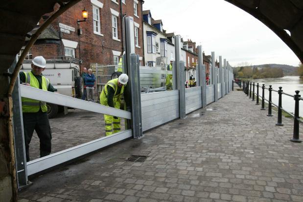
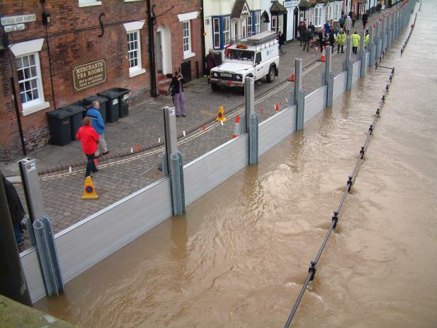
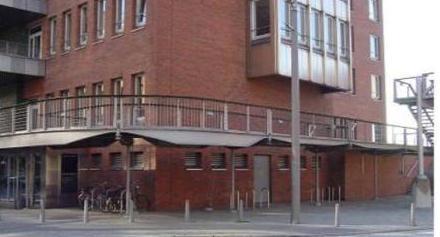
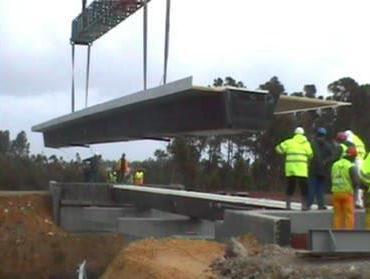
5 Reliability of Urban Flood defense Flood protection wall, Severn River, Bewdley, UK 25/07/2014 5

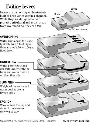
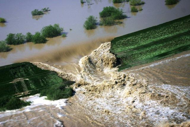
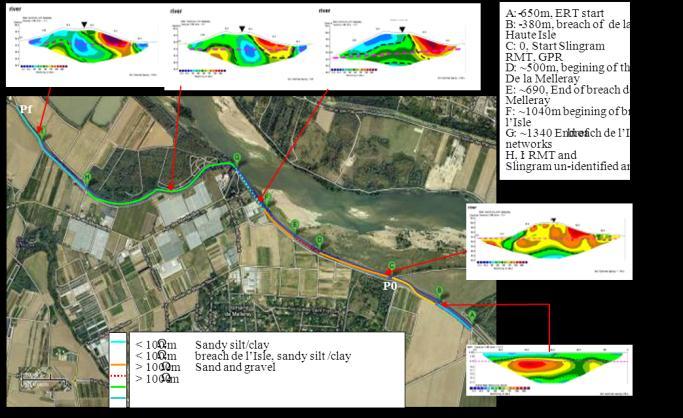
6 General framework for assessment of levees Segment assessment: Internal erosion Vegetation Transitions System assessment: Geophysical methods Remote sensing methods / Lidar 25/07/2014 6

7 Flood defences: Transitions - type and potential problems 25/07/2014 7
 Guidance for")


8 Rés.App. (Ohm.m) Guidance for geophysics Rapid general investigation of very long stretches mars-09 oct-09 avr x (m)


9 Letterkenny Hospital, Donegal, Ireland 26 July 2013 Vulnerability of critical infrastructure (CI) and high density value assets Ft. Calhoun Nuclear Power Plant, Nebraska, USA June 2011 A4 Highway at San Bonifacio, Verona, Italy 31 March 2011 Durham city center, UK 28 November /07/2014 9


10 System analysis: critical infrastructure and hotspots 25/07/


11 Simple tool: assets risk assessment matrix 25/07/


12 Flood-damage estimation of buildings according to their construction 25/07/


13 Failure Modes Effects Analysis: components/networks interdependency 25/07/


14 Construction technologies and concepts for flood defences and damage mitigation 25/07/2014

15 General framework and a Quick Scan tool Interventions
16 Multifunctional flood defence: choosing technology and functions 25/07/

17 Example of catalogue of Multifunctional Flood Defences options 25/07/
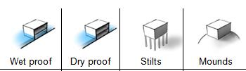
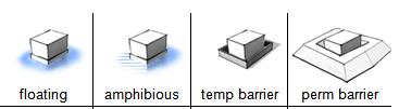
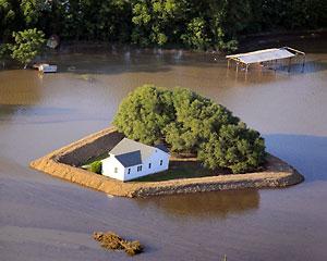

18 Floodproofing concepts for hotspot buildings 25/07/
19 Floodproofing hotspot buildings: Applicability 25/07/
20 Floodproofing critical infrastructures (technologies) 25/07/
21 Policy brief 1: Important lessons that require imediate action Critical Infrastructures is not given enough attention from flood risk perspective. Different stakeholders are responsible for direct and indirect consequences such as societal disruption. Transitions are often the main cause for flooding due to failure of the flood defences, but transitions are widely ignored in safety assessments Start gathering data during and right after events 25/07/
22 Beyond FloodProBE, ILH and FP7 FLOODrisk2016 Palais des Congres, Lyon (F) st October 2016 Organised by IRSTEA with support from HRW, Deltares and Samui Establish a self sustaining international Flood Risk Management Community of Practice Shared view from e.g. FloodProBE / ILH-project-teams and conference participants to ensure continuity and expansion of existing networks Opportunity to kick-start initiative by submitting EU-proposal under Horizon2020 Water 4a 2014 Call Current status: 10 core partners, >30 confirmed associate partners expected to grow to approx /07/
23 What are Communities of Practice? groups of people who share Jackie Banks, EA a concern, a set of problems or a passion about a topic, and who deepen their knowledge and expertise in this area by interacting on an ongoing basis Etienne Wenger, Richard McDermott, William Snyder (2002). Cultivating communities of practice: a guide to managing knowledge. Boston MA: Harvard Business School Press 23
24 Community of Practice Platform that allows a) an overview of solutions and b) flexibility to create, develop and share new ideas and solutions Means: Joint meetings/workshops of policy makers, researchers, engineers and managers Policy formulation Research formulation Share experiences from implementation projects Web-based platform: discussion forum, exchange of tools, data collection and repository Guidance and training, advisory services 25 juli 2014
25 The Flood ProBE project Thank you for your attention! Further information: 25/07/
Space Weather & Critical Infrastructures
 Space Weather & Critical Infrastructures Italy Organisers EC JRC, MSB, UK Met Office Date and Venue 29-30 November 2016, JRC Ispra, Background Our modern technological infrastructures on the ground and
Maritime Spatial Planning: Transboundary Cooperation in the Celtic Seas Looking Ahead
 Maritime Spatial Planning: Transboundary Cooperation in the Celtic Seas Looking Ahead Looking ahead MSP in the context of the European Maritime and Fisheries Fund (EMFF) and beyond SIMCelt Final Conference
BIM and INSPIRE, for a better integration of built infrastructures in their environment : the MINnD project
 BIM and INSPIRE, for a better integration of built infrastructures in their environment : the MINnD project François ROBIDA Christophe CASTAING Strasbourg, > 1 8 septembre 2017 ABOUT BIM Building Information
Framework on reducing diffuse pollution from agriculture perspectives from catchment managers
 Framework on reducing diffuse pollution from agriculture perspectives from catchment managers Photo: River Eden catchment, Sim Reaney, Durham University Introduction This framework has arisen from a series
Regional stakeholders strategy of Donegal County Council
 Regional stakeholders strategy of Donegal County Council Table of contents The template comprised five steps in the creation of this communication strategy: 1 Starting point. Communication objectives...
Weather forecasts and warnings: Support for Impact based decision making
 Weather forecasts and warnings: Support for Impact based decision making Gerry Murphy, Met Éireann www.met.ie An Era of Change Climate and weather is changing Societal vulnerability is increasing The nature
New Prospects for Peripheral Rural Regions Helmut Hiess Glasgow, 19th of May 2010
 New Prospects for Peripheral Rural Regions Helmut Hiess Glasgow, 19th of May 2010 ÖROK: Organisation & Tasks Austrian Conference on Spatial Planning (ÖROK, since 1971): Joint organisation by Federal level,
Urban Climate Resilience
 Urban Climate Resilience in Southeast Asia Partnership Project Introduction Planning for climate change is a daunting challenge for governments in the Mekong Region. Limited capacity at the municipal level,
Status & Challengers of Cook Islands GEO DRM. Cook Islands GEO S/GIS History
 Status & Challengers of Cook Islands GEO DRM By Patrick A. ARIOKA Planning & Advisory Officer EMERGENCY MANAGEMENT COOK ISLANDS Cook Islands GEO S/GIS History 1990 NZODA/MFAT trained by Landcare Research
Hurricane Readiness for Coastal Communities
 Hurricane Readiness for Participant Guide Developed for: Federal Emergency Management Agency Emergency Management Institute 16825 South Seton Avenue Emmitsburg, MD 21727-8998 Developed by: C² Technologies,
Harmonizing spatial databases and services at local and regional level
 Harmonizing spatial databases and services at local and regional level A. Ionita 1, M. Caian 2, V. Vassilev 3, V. Craciunescu 2, I. Nedelcu 4 1 Research Institute for Artificial Intelligence, Bucuresti,
Maritime Spatial Planning
 Maritime Spatial Planning The Dutch experience Kopenhagen 28 november 2012 Lodewijk.Abspoel@minienm.nl North Sea 2 Outline History of MSP in the Netherlands Spatial Plan for the Dutch EEZ, principles and
City of Manitou Springs
 March 2018 City of Manitou Springs Implementing Land Use tools to reduce and mitigate natural hazard risk Context & History Past Present Historic homes Older infrastructure Hillside development Creekside
PART A Project summary
 PART A Project summary A.1 Project identification Project title Project acronym Name of the lead partner organisation in English Specific objective Demonstrattion AF DAF Partner 1.1. Improving innovation
Advancing Geoscientific Capability. Geological Survey of Finland
 Advancing Geoscientific Capability Geological Survey of Finland GTK in brief The Geological Survey of Finland (GTK) is one of the largest European centres of excellence in assessment, research and the
Jordan's Strategic Research Agenda in cultural heritage
 Jordan's Strategic Research Agenda in cultural heritage Analysis of main results Alessandra Gandini Amman, Jordan 3 rd November 2013 Main objectives The work performed had the main objective of giving
ESPON evidence on European cities and metropolitan areas
 BEST METROPOLISES Final Conference 18 April 2013, Warsaw ESPON evidence on European cities and metropolitan areas Michaela Gensheimer Structure of Intervention Content Part I: What is the ESPON 2013 Programme?
Copernicus Overview. Major Emergency Management Conference Athlone 2017
 Copernicus Overview Major Emergency Management Conference Athlone 2017 Copernicus is a European programme implemented by the European Commission. The services address six thematic areas: land, marine,
Ministry of Health and Long-Term Care Geographic Information System (GIS) Strategy An Overview of the Strategy Implementation Plan November 2009
 Strategy An Overview of the Strategy Implementation Plan November 2009") Ministry of Health and Long-Term Care Geographic Information System (GIS) Strategy An Overview of the Strategy Implementation Plan November 2009 John Hill, Health Analytics Branch Health System Information
Ministry of Health and Long-Term Care Geographic Information System (GIS) Strategy An Overview of the Strategy Implementation Plan November 2009 John Hill, Health Analytics Branch Health System Information
The Swedish National Geodata Strategy and the Geodata Project
 The Swedish National Geodata Strategy and the Geodata Project Ewa Rannestig, Head of NSDI Co-ordination Unit, Lantmäteriet, ewa.rannstig@lm.se Ulf Sandgren, Project Manager Geodata Project, Lantmäteriet,
Smart Flood Risk Management Solutions
 Smart Flood Risk Management Solutions - RHDHV s Experience in the Gulf of Mexico Mathijs van Ledden, Marten Hillen and Ries Kluskens Challenge Extreme weather around the world (hurricanes, cyclones, extratropical
Smart City PROFILES. The Austrian smart cities and their indicators results and conclusions. GSWF, May 26 th 2015, Lisbon, Portugal
 The Austrian smart cities and their indicators results and conclusions Smart City PROFILES GSWF, May 26 th 2015, Lisbon, Portugal Andreas Littkopf; Pia Thielen, Alexander Storch Environment Agency Austria
PURR: POTENTIAL OF RURAL REGIONS UK ESPON WORKSHOP Newcastle 23 rd November Neil Adams
 PURR: POTENTIAL OF RURAL REGIONS UK ESPON WORKSHOP Newcastle 23 rd November 2012 Neil Adams PURR: Potential of Rural Regions Introduction Context for the project A spectrum of knowledge Rural Potentials
The SedAlp Project: WP6: INTERACTION WITH STRUCTURES
 The SedAlp Project: WP6: INTERACTION WITH STRUCTURES 6 th International conference Water in the Alps Herrenchiemsee, 12 th of October, 2016 Jošt Sodnik Contents Structure of SedAlp project (www.sedalp.eu)
Spatial decision making in Armenia based on multidisciplinary environmental research
 EU FP7 EcoArm2ERA Integration into ERA Integration of spatial decision support systems and evidence based modeling in National/Regional Policy applications and regulatory systems: scientific and policy
Copernicus Overview and Emergency Management Service
 Copernicus Overview and Emergency Management Service Frédéric BASTIDE European Commission Open informal session of the United Nations Inter-Agency Meeting on Outer Space Activities 12 March 2013, Geneva
United States Multi-Hazard Early Warning System
 United States Multi-Hazard Early Warning System Saving Lives Through Partnership Lynn Maximuk National Weather Service Director, Central Region Kansas City, Missouri America s s Weather Enterprise: Protecting
The ESPON Programme and the use of spatial data on the European level
 The ESPON Programme and the use of spatial data on the European level Plan4Business project ISOCARP Brussels Liaison Office 29 November 2013 Marjan van Herwijnen Project Expert - ESPON Coordination Unit
2018/1 The integration of statistical and geospatial information. The Regional Committee of UN-GGIM: Americas:
 The following are the conclusions and recommendations of the Regional Committee of the United Nations on Global Geospatial Information Management for the Americas, during its Fifth Session, Thursday 8
Network of European Regions Using Space Technologies
 NEREUS Network of European Regions Using Space Technologies Core mission NEREUS WHAT IS SPACE ABOUT??? Spreading use of space technologies at regional level Stimulating the development of space applications
Weather Climate Science to Service Partnership South Africa
 PROJECTS UNDERWAY Title of the Weather Climate Science to Service Partnership South Africa Together, building on an existing strong partnership, South African Weather Service and the Met Office will build
Norwegian spatial data infrastructure supporting disaster risk management Norwegian Mapping Authority
 Norwegian spatial data infrastructure supporting disaster risk management Norwegian Mapping Authority Arvid Lillethun, Norwegian Mapping Authority Land and Poverty 2018 Conference, World Bank 19.-23. March
Report on the establishment of UN GGIM: Europe Item 14. 4th session of the Committee of Experts on UN-GGIM
 Report on the establishment of UN GGIM: Europe Item 14 1 Why regional European committees of UN GGIM? In the ECOSOC resolution 2011/24 on the UN GGIM: Emphasizes the importance of promoting national, regional
Storm Surge/Coastal Inundation State of the Union. Jamie Rhome Storm Surge Team Lead NOAA/National Hurricane Center
 Storm Surge/Coastal Inundation State of the Union Jamie Rhome Storm Surge Team Lead NOAA/National Hurricane Center 2 Tampa: Cat 5 Scenario 3 4 The Stakes are High Combination of SLR and increasing coastal
Colin Bray, OSi CEO. Articulating the Data Needs for SDGs. Collaboration in Ireland
 Ireland Colin Bray, OSi CEO Articulating the Data Needs for SDGs Collaboration in Ireland Articulating the Data Needs for SDGs Ireland Introduction Collaboration between the Irish National Mapping Agency
Fluvial Erosion Impacts on Infrastructure Along Indiana Rivers and Streams
 Fluvial Erosion Impacts on Infrastructure Along Indiana Rivers and Streams Siavash Beik, Robert Barr, Brian Meunier 2017 Purdue Road School March 6-9, 2017 In June 2008, flooding damaged or destroyed
Implementation of the ESPON 2020 cooperation program. 16 January 2017 Anneloes van Noordt
 Implementation of the ESPON 2020 cooperation program 16 January 2017 Anneloes van Noordt Outline! ESPON Cooperation Program! Specific Objectives! Applied Research! Targeted Analysis! Database & Tools!
SCENT: A Smart Toolbox for Engaging Citizens into a People Centric Observation Web. INSPIRE 2016 Conference Barcelona, 28 September 2016
 SCENT: A Smart Toolbox for Engaging Citizens into a People Centric Observation Web INSPIRE 2016 Conference Barcelona, 28 September 2016 Summary SCENT Facts & figures Motivation SCENT @ a glance SCENT objectives
The UK Flood Forecasting Centre
 Storm Surge Networking Forum, Venice: Tuesday 19 th November 2013 The UK Flood Forecasting Centre Dave Cox - Senior Hydrometeorologist FFC Exeter, England. In My talk today I will cover: Ü Overview of
Intense Precipitation Events and Flooding
 Intense Precipitation Events and Flooding Climate Disruption & Our Water Future: Mitigate, Adapt or Suffer A Call for New Strategies Middle Rio Grande Water Assembly Saturday, March 21, 2015 Michael Jensen
Scenario development for reaching urban and environmental planning integration in the context of climate change*.
 Scenario development for reaching urban and environmental planning integration in the context of climate change*. PhD (cand) Verónica Zagare (TUDelft, ) Dr. Diego Sepúlveda Carmona (TUDelft) September
TERRITORIAL IMPACT ASSESSMENT: AN APPROACH TO IMPROVE THE VERTICAL AND HORIZONTAL INTEGRATION OF EU POLICIES
 TERRITORIAL IMPACT ASSESSMENT: AN APPROACH TO IMPROVE THE VERTICAL AND HORIZONTAL INTEGRATION OF EU POLICIES Naja Marot & Mojca Golobič Biotehnical Faculty, University of Ljubljana, Slovenia RSA Workshop
GIS based modeling of chemical fate, transport and impacts for policy support
 GENERAL INFORMATION Chemical risk communication and management increasingly requires mapping of exposure and vulnerability. Maps are often ideal tools both from the perspective of public decision makers,
2014 Russell County Hazard Mitigation Plan Update STAKEHOLDERS AND TECHNICAL ADVISORS MEETING 2/6/14
 2014 Russell County Hazard Mitigation Plan Update STAKEHOLDERS AND TECHNICAL ADVISORS MEETING 2/6/14 Welcome and Introductions We cannot direct the wind, but we can adjust our sails. 44 CFR 201.6; Local
Dynamic Coast. Coastal erosion / Management Briefing to THC
 Dynamic Coast Coastal erosion / Management Briefing to THC What is Dynamic Coast? Dynamic Coast is a Scottish Government project, funded by CREW, managed by SNH, with a research team from the University
The World Bank Cities and Climate Change (P123201)
") Public Disclosure Authorized AFRICA Mozambique Social, Urban, Rural and Resilience Global Practice Global Practice IBRD/IDA Investment Project Financing FY 2012 Seq No: 13 ARCHIVED on 17-May-2018 ISR31517
Public Disclosure Authorized AFRICA Mozambique Social, Urban, Rural and Resilience Global Practice Global Practice IBRD/IDA Investment Project Financing FY 2012 Seq No: 13 ARCHIVED on 17-May-2018 ISR31517
Virginia Shoreline Mapping Tools
 Virginia Shoreline Mapping Tools December 15, 2017 Karen Duhring Center for Coastal Resources Management Virginia Institute of Marine Science College of William & Mary Virginia Shoreline Mapping Tools
PROGRESS REPORT ON APPROACH PAPER THE IMPLEMENTATION OF THE GEF KNOWLEDGE MANAGEMENT. GEF/C.49/Inf.04 September 23, 2015
 49 th GEF Council Meeting October 20 22, 2015 Washington, D.C. GEF/C.49/Inf.04 September 23, 2015 PROGRESS REPORT ON THE IMPLEMENTATION OF THE GEF KNOWLEDGE MANAGEMENT APPROACH PAPER TABLE OF CONTENTS
RISC-KIT: EWS-DSS Hotspot Tool
 RISC-KIT: EWS-DSS Hotspot Tool Robert McCall Ap van Dongeren Deltares www.risckit.eu This project has received funding from the European Union s Seventh Programme for Research, Technological Development
Delta Flood Protection Strategy Update. May 16, 2016
 Delta Flood Protection Strategy Update May 16, 2016 Presentation Overview 1. Background 2. Understanding the Dike Reaches/Issues 3. Future Dike Improvements 4. Next Steps Boundary Bay Village March 10,
GOVERNMENT MAPPING WORKSHOP RECOVER Edmonton s Urban Wellness Plan Mapping Workshop December 4, 2017
 GOVERNMENT MAPPING WORKSHOP 12.4.17 RECOVER Edmonton s Urban Wellness Plan Mapping Workshop December 4, 2017 In July of 2017, City Council directed administration to develop RECOVER, Edmonton s Urban Wellness
Coastal Inundation Forecasting Demonstration Project (CIFDP)
") WMO World Meteorological Organization Working together in weather, climate and water Coastal Inundation Forecasting Demonstration Project (CIFDP) WMO Technical Commission for Oceanography and Marine Meteorology
WMO World Meteorological Organization Working together in weather, climate and water Coastal Inundation Forecasting Demonstration Project (CIFDP) WMO Technical Commission for Oceanography and Marine Meteorology
Briefing. H.E. Mr. Gyan Chandra Acharya
 Briefing by H.E. Mr. Gyan Chandra Acharya Under-Secretary-General and High Representative for the Least Developed Countries, Landlocked Developing Countries and Small Island Developing States Briefing
The inland water related tourism in South Africa by 2030 in the light of global change
 The inland water related tourism in South Africa by 2030 in the light of global change KSA 2 Water-Linked Ecosystems T4: Green economy and sustainable (green) innovations K5/2620 How can natural capital
Grant agreement number:
 EU Framework Programme 7 theme Community-based management of environmental challenges; funding scheme Research for the benefit of specific groups - Civil Society Organisations. Grant agreement number:
ASEV - Partner presentation
 ASEV - Partner presentation Lorenzo Sabatini Head of RTD project area l.sabatini@asev.it 20th-21st February, 2017 Kickoff meeting - Porto About ASEV ASEV - Agenzia per lo Sviluppo Empolese Valdelsa Spa
Strategic Framework on Geospatial Information and Services for Disasters
 Strategic Framework on Geospatial Information and Services for Disasters Case Studies for the Caribbean and the Philippines --- Kunming Forum on United Nations Global Geospatial Information Management
Securing EUMETSAT s Mission from an Evolving Space Environment
 Securing EUMETSAT s Mission from an Evolving Space Environment ESPI 12 th Autumn Conference Andrew Monham 1 EUMETSAT: Intergovernmental Organisation of 30 Member States Presentation Contents AUSTRIA BELGIU
Cities and Climate Change (P123201)
") Public Disclosure Authorized AFRICA Mozambique Social, Urban, Rural and Resilience Global Practice Global Practice IBRD/IDA Investment Project Financing FY 2012 Seq No: 14 ARCHIVED on 04-Nov-2018 ISR33750
Public Disclosure Authorized AFRICA Mozambique Social, Urban, Rural and Resilience Global Practice Global Practice IBRD/IDA Investment Project Financing FY 2012 Seq No: 14 ARCHIVED on 04-Nov-2018 ISR33750
The Role of Urban Planning and Local SDI Development in a Spatially Enabled Government. Faisal Qureishi
 The Role of Urban Planning and Local SDI Development in a Spatially Enabled Government Faisal Qureishi 1 Introduction A continuous increase in world population combined with limited resources has lead
Project Name: Income Generation Project 4 Pouk District, Siem Reap Province Implementing Partner: Farmer Livelihood Development (FLD)
") Grant Category: Micro Finance Project Name: Income Generation Project 4 Pouk District, Siem Reap Province Implementing Partner: Farmer Livelihood Development (FLD) Status: Ongoing Start Date: 1 April 2012
Grant Category: Micro Finance Project Name: Income Generation Project 4 Pouk District, Siem Reap Province Implementing Partner: Farmer Livelihood Development (FLD) Status: Ongoing Start Date: 1 April 2012
Terms of Reference for the Comparative Environmental Review (CER) of. Options for the Mactaquac Project, Mactaquac, New Brunswick
 of. Options for the Mactaquac Project, Mactaquac, New Brunswick") Terms of Reference for the Comparative Environmental Review (CER) of Options for the Mactaquac Project, Mactaquac, New Brunswick Preamble The New Brunswick Power Corporation ( NB Power ) operates the Mactaquac
Terms of Reference for the Comparative Environmental Review (CER) of Options for the Mactaquac Project, Mactaquac, New Brunswick Preamble The New Brunswick Power Corporation ( NB Power ) operates the Mactaquac
KUNMING FORUM ON UNITED NATIONS GLOBAL GEOSPATIAL INFORMATION MANAGEMENT CITIES OF THE FUTURE: SMART, RESILIENT
 KUNMING FORUM ON UNITED NATIONS GLOBAL GEOSPATIAL INFORMATION MANAGEMENT CITIES OF THE FUTURE: SMART, RESILIENT and SUSTAINABLE Yunnan Zhenzhuang Guest House, Kunming, China 10 12 May 2017 BACKGROUND CONCEPT
Paul Bridge Meteorologist Vaisala/UKMO Work Groups/Committees: WMO/TRB/AMS
 Paul Bridge Meteorologist Vaisala/UKMO Work Groups/Committees: WMO/TRB/AMS Introduction (a) Identify and establish, if possible, inventories of transport networks in the ECE region which are vulnerable
Introduction and Project Overview
 Greater New Orleans Regional Land Use Modeling GIS Techniques in a P olitical C ontext Louisiana Remote Sensing and GIS Workshop Wednesday, April 24, 2013 Working Towards a Shared Regional Vision Introduction
Flood Mapping Michael Durnin October 9 th
 Michael Durnin October 9 th 2014 Leading Surveyors Company Profile Est. 1983 Celebrating 30 Years in Business Six Offices in UK & Ireland Over 30 Specialised Survey Services ISO 9001:2008 Registered Over
VBHC, making it happen together. G é r a r d K l o p F o u n d e r & P a r t n e r V i n t u r a M a y 11 th,
 VBHC, making it happen together G é r a r d K l o p F o u n d e r & P a r t n e r V i n t u r a M a y 11 th, 2 0 1 7 1 V i n t u r a i s c o m m i t t e d t o m a k i n g V B H C h a p p e n WHAT WE DO
Alps Results from the ESPON Project. Common spatial perspectives for the Alpine area. Towards a common vision
 Results from the ESPON Project Alps 2050 Common spatial perspectives for the Alpine area. Towards a common vision Tobias Chilla, University of Erlangen Cooperation Alps 2020+ 1 & 2 October 2018 Salzburg
THE FIRE AND RESCUE SERVICE S ROLE IN RESPONDING TO FLOODING DAVE RUSSEL ASSISTANT CHIEF FIRE OFFICER
 THE FIRE AND RESCUE SERVICE S ROLE IN RESPONDING TO FLOODING DAVE RUSSEL ASSISTANT CHIEF FIRE OFFICER RESPONDING TO FLOODING NATIONAL CONTEXT Fire and Rescue Services Act 2004: Power to respond to floods
Urban Water Supply Project (P156739)
") AFRICA Cote d'ivoire Water Global Practice IBRD/IDA Investment Project Financing FY 2017 Seq No: 4 ARCHIVED on 04-Oct-2018 ISR33891 Implementing Agencies: Republic of Cote d'ivoire, Cellule de Coordination
AFRICA Cote d'ivoire Water Global Practice IBRD/IDA Investment Project Financing FY 2017 Seq No: 4 ARCHIVED on 04-Oct-2018 ISR33891 Implementing Agencies: Republic of Cote d'ivoire, Cellule de Coordination
The Joint Programming Initiative on Cultural Heritage (JPICH): European perspective
: European perspective") COPERNICUS FOR CULTURAL HERITAGE Copernicus User Forum Industry Workshop Brussels, 24 April 2017 The Joint Programming Initiative on Cultural Heritage (JPICH): European perspective Cristina Sabbioni CNR,
COPERNICUS FOR CULTURAL HERITAGE Copernicus User Forum Industry Workshop Brussels, 24 April 2017 The Joint Programming Initiative on Cultural Heritage (JPICH): European perspective Cristina Sabbioni CNR,
Health DWG ad-hoc. May 31 st, 2013 OGC-TC
 Health DWG ad-hoc May 31 st, 2013 OGC-TC AGENDA 1. Welcome / Roundtable Introductions 2. Background of OGC and proposal of Health DWG 3. Toward an OGC Health DWG 4. Draft Health DWG Charter 5. Potential
Copernicus EMS: Αξιολόγηση πολλαπλών φυσικών κινδύνων - Σχεδιασμός και Ανάκτηση
 Building Capacity for a Centre of Excellence for EO-based monitoring of Natural Disasters Copernicus EMS: Αξιολόγηση πολλαπλών φυσικών κινδύνων - Σχεδιασμός και Ανάκτηση Γιάννης Παπουτσής ΙΑΑΔΕΤ Εθνικό
Challenges and Successes in Sharing Geospatial Data in Africa
 Challenges and Successes in Sharing Geospatial Data in Africa 2018 GeoNode Summit Torino, Italy March 26-28, 2018 Bernard Justus Muhwezi Manager, Geo-Information Services Uganda Bureau of Statistics, Kampala,
A science-policy approach towards local adaptation planning: The case of Santiago de Chile
 A science-policy approach towards local adaptation planning: The case of Santiago de Chile Kerstin Krellenberg, PhD Resilient Cities 2011 2nd World Congress on Cities and Adaptation to Climate Change Bonn,
Presentation of the gicases case studies Carlo Cipolloni ISPRA Giorgio Saio GISIG Dirk Frigne GEOSPARC Elena Krikigianni EPSGR
 Presentation of the gicases case studies Carlo Cipolloni ISPRA Giorgio Saio GISIG Dirk Frigne GEOSPARC Elena Krikigianni EPSGR 1 Which are the gicases Case study? CS1 - Use of indoor GIS in healthcare
E-Learning with EuroSDR. Arpad Barsi BME Dept. of Photogrammetry and Geoinformatics
 E-Learning with EuroSDR Arpad Barsi BME Dept. of Photogrammetry and Geoinformatics Motto and goal Learning by doing Distance learning courses for EU and non-eu country students with a short introduction
Climate Services in Practice UK Perspective
 Climate Services in Practice UK Perspective Chris Hewitt ICCS, Columbia University, October 2011 Overview Perspectives on: Why have a climate service? What is a climate service? UK activities Examples
ERA-NET CRUE Funding Initiative. Risk Assessment and Risk Management in Small Urban Catchments
 ERA-NET CRUE Funding Initiative Integrate, Consolidate and Disseminate European Flood Risk Management Research Kick-off Meeting of Research Projects Risk Assessment and Risk Management in Small Urban Catchments
Current LCLUC challenges in SCERIN: Assessing Ecosystem Function and Processes
 Summary of the SCERIN 2 meeting Current LCLUC challenges in SCERIN: Assessing Ecosystem Function and Processes Katarzyna Ostapowicz Department of GIS, Cartography and Remote Sensing, Institute of Geography
The Future of Tourism in Antarctica: Challenges for Sustainability
 The Future of Tourism in Antarctica: Challenges for Sustainability Machiel Lamers Thesis summary In the last decade, Antarctic tourism has grown rapidly both in terms of volume and diversity. This growth
What s next for the Port Waterfront?
 What s next for the Port Waterfront? WATERFRONT LAND USE PLAN UPDATE The Port of San Francisco s Waterfront Land Use Plan ( Waterfront Plan ) guides land use and development on the Port s 7 1/2 mile public
Plenary Session 2, part 2 A European shared information system
 3 rd GMES Forum 5 6 June 2003 Athens Plenary Session 2, part 2 A European shared information system Gordon McInnes Deputy Director European Environment Agency 1 I keep six honest serving men. They taught
Canada s Experience with Chemicals Assessment and Management and its Application to Nanomaterials
 Canada s Experience with Chemicals Assessment and Management and its Application to Nanomaterials European Chemicals Agency (ECHA) Topical Scientific Workshop: Regulatory Challenges in Risk Assessment
Conclusions and further thoughts on changes within ESTEP as preparation for the broader discussion within ESTEP
 European Steel Technology Platform Avenue de Cortenbergh, 172 B-1000 Brussels Belgium T +32 (2) 738 79 47 F+32 (2) 738 79 56 klaus.peters@estep.eu http://cordis.europa.eu/estep/ Klaus Peters, SG ESTEP
Urban storm water management
 Urban storm water management Cooperation between geologists and land-use planners Philipp Schmidt-Thomé Geological Survey of Finland Background Urban flood modeling has become more topical during 21 st
GIS and Remote Sensing Support for Evacuation Analysis
 GIS and Remote Sensing Support for Evacuation Analysis Presented to GIS for Transportation Symposium Rapid City, South Dakota March 28-31, 2004 Demin Xiong Oak Ridge National Laboratory 2360 Cherahala
Ocean meets Regions conference Committee of the Regions, Brussels 21 November 2017 Cecilia Donati. Marine Monitoring.
 Implemented by C o p e r n i c u s M a r i n e S e r v i c e : a E u r o p e a n t o o l i n s u p p o r t o f P u b l i c A d m i n i s t r a t i o n f o r a s u s t a i n a b l e B l u e G r o w t h
"Outcomes of the storm surge and waves workshop in Dominican Republic and the questionnaire"
 "Outcomes of the storm surge and waves workshop in Dominican Republic and the questionnaire" Strengthening Regional Cooperation to Support Forecasting with Multi Hazard Approach in RA IV Ritz Carlton Grand
The global challenges in Flanders (Belgium)
") The global challenges in Flanders (Belgium) Key questions for strategic spatial planning Peter Cabus Overall title of the expert meeting: Global challenges in polycentric regions What role for strategic
The global challenges in Flanders (Belgium) Key questions for strategic spatial planning Peter Cabus Overall title of the expert meeting: Global challenges in polycentric regions What role for strategic
Overview of Early Warning Systems and the role of National Meteorological and Hydrological Services
 Overview of Early Warning Systems and the role of National Meteorological and Hydrological Services South Africa Second Experts Symposium on Multi-Hazard Early Warning Systems With focus on the Role of
SPLAN-Natura Towards an integrated spatial planning approach for Natura th January, 2017 Brussels. Commissioned by DG Environment
 SPLAN-Natura 2000 Towards an integrated spatial planning approach for Natura 2000 Commissioned by DG Environment 17 th January, 2017 Brussels V. Simeonova (Ph.D.) Drivers towards integrating Biodiversity
European Severe Weather
 European Severe Weather Management & Communications Paul Arnold National Weather Strategy Specialist Network Rail U.K. Introduction U.K. - The 2009/10 winter was the 3 rd coldest in the last 50 years and
SDC s Global Programme Climate Change
 SDC s Global Programme Climate Change SDC activities and strategies in the KHK region Indus Forum Workshop Switzerland 13 October 2016 ABOUT SDC IN INDIA BACKGROUND A technical cooperation partner of India
Arctic ecosystem services: TEEB Arctic Scoping study. Alexander Shestakov WWF Global Arctic Programme 3 December Arctic Biodiversity Congress
 Arctic ecosystem services: TEEB Arctic Scoping study Alexander Shestakov WWF Global Arctic Programme 3 December 20143 Arctic Biodiversity Congress Content 1. Project design 2. Approach 3. Challenges and
NSDI Implementation. Milo Robinson FGDC. U. S. Policy OMB Circular A-16 From Global GSDI To Local Canadian/ U.S. Projects
 NSDI Implementation Milo Robinson FGDC U. S. Policy OMB Circular A-16 From Global GSDI To Local Canadian/ U.S. Projects Federal Geographic Data Committee (FGDC) A US Federal Interagency committee responsible
Low Density Areas : Places of Opportunity. Enrique Garcilazo, OECD Directorate for Public Governance and Territorial Development
 Low Density Areas : Places of Opportunity Enrique Garcilazo, OECD Directorate for Public Governance and Territorial Development Open Days, Brussels, 11 th October, 2016 Outline 1. Performance low density
EuroGEOSS Protected Areas Pilot
 EuroGEOSS Protected Areas Pilot Max Craglia European Commission Joint Research Centre Part 1: the present MyNatura2000 Mobile app. Awareness raising & volunteered data collection. Natura2000 covers 18%
Progress on the Development of the Strategic Framework on Geospatial Information and Services for Disasters
 Progress on the Development of the Strategic Framework on Geospatial Information and Services for Disasters Dr. Peter N. Tiangco Administrator, NAMRIA, Philippines Co-chair, Working Group on Geospatial
EXPLORING COMMON SOLUTIONS IN ARCTIC METEOROLOGY FINLAND S CHAIRMANSHIP OF THE ARCTIC COUNCIL
 EXPLORING COMMON SOLUTIONS IN ARCTIC METEOROLOGY FINLAND S CHAIRMANSHIP OF THE ARCTIC COUNCIL 2017 2019 GENERAL OBJECTIVES Finland chairs the Arctic Council in 2017-2019. One of the chairmanship priorities