Earthquake Lab 15.1 Distance to Epicenter and Location of Epicenter
|
|
|
- Susanna Kelly
- 5 years ago
- Views:
Transcription
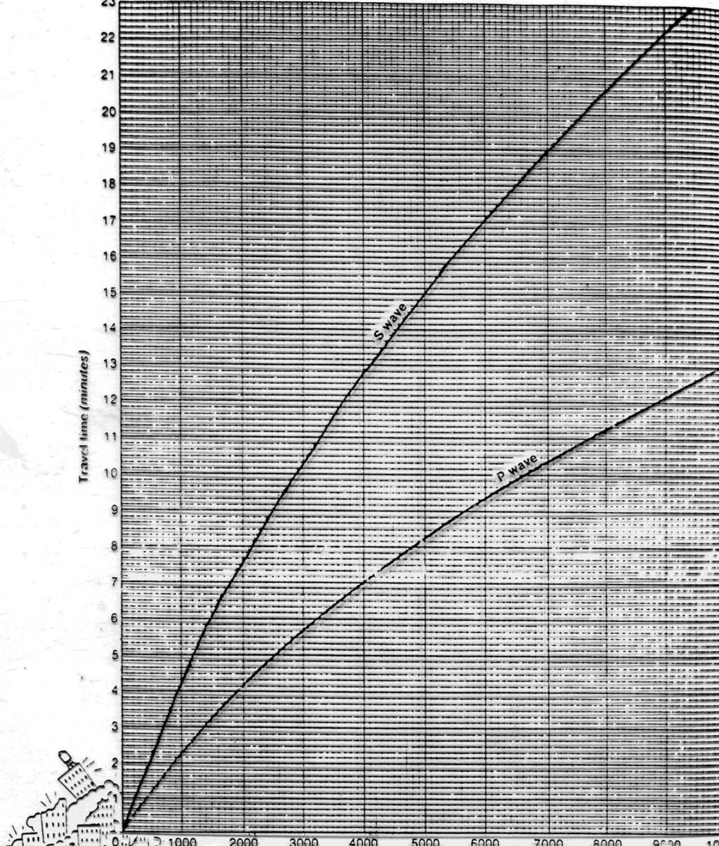
1 Earthquake Lab 15.1 Distance to Epicenter and Location of Epicenter Objectives: Materials: To learn how to determine distances from seismographs to epicenters To learn how to determine the location of epicenters using 3 or more seismographs Circle compass Map P-S Waves Velocity Chart/Graph (separate sheet) Scrap Paper Procedure Part A: Distance to Epicenter 1. Use the P-S Waves Velocity Chart/Graph to help answer the following questions (see Part A Questions) 2. For: a. P-wave arrival time (Question 1) i. Go to distance measurement on horizontal axis ii. Go up to O-wave curved line. Stop. iii. Now go left to time axis iv. Read time (each line is 10 seconds) b. S-wave arrival time (Question 2) i. Go to distance measurement on horizontal axis ii. Go up to S-wave curved line. Stop. iii. Now go left to time axis iv. Read time (Each line is 10 seconds) c. P-wave epicenter to seismograph distance (Question 3) i. Go to time measurement on vertical axis ii. Go right to P-wave curved line. Stop. iii. Go down to distance axis iv. Read distance (km) d. S-wave epicenter to seismograph distance (Question 4) i. Go to time measurement on vertical axis ii. Go right to S-wave curved line. Stop. iii. Go down to distance axis iv. Read distance (km) e. Distance from epicenter to seismograph using P-S arrival time differences (Question 5)
2 i. Using scrap paper, mark time difference from vertical time axis ii. Now take the scrap of paper and move it so the two mark for time difference fits exactly between the P-wave curve and the S-wave curve iii. Go down to distance axis iv. Read distance (km) f. Time from epicenter to seismograph if distance is known (Question 6) i. Go to distance measurement on horizontal axis ii. Go up to P-wave and S-wave curved line iii. Measure the vertical distance between the two curved lines with a scrap paper iv. Put scrap paper along time axis to get time reading Questions Part A: (10 marks) 1. How much time does it take for a P-wave to get to the seismograph from a distance of a. 1000km: min b. 3500km: min c. 8000km: min 2. How much time does it take for a S-wave to get to the seismograph from a distance of a. 2000km: min b. 4500km: min c. 8000km: min 3. How far is the epicenter away if the P-wave arrives in minutes? a. 3 min: km b. 5 min: km c. 7:48 min: km 4. How far is the epicenter away if the S-wave arrives in minutes? a. 3 min: km b. 10:12 min: km c. 22:24 min: km 5. How far is the epicenter away if the difference in the P-wave/S-wave arrival times is minutes? a. 2 min: km b. 3:24 min: km c. 5:30 min: km 6. What is the difference in the P-wave/S-wave arrival times if the epicenter is km away? a km: min b. 500 km: min c km: min Procedure Part B-1: Location of Epicenter #1 (7 marks) 1. Get a circle compass. What the sharp tip! Be very, very careful! 2. On the P-S Waves Velocity Chart/Graph you are given the time difference between P-wave and S-wave arrivals. Determine the distance to the epicenter from each seismograph (like Question 5 in Part A). (3 marks) 3. Go to the map of North America ( Part B-1 Location of Epicenter #1 ). Look at the bottom of the page and refer to the map scale 4. Now put the sharp, pointy, needle tip on the 0 of the scale.
3 5. Open the compass to the distance to epicenter you calculated for Chicago (until the pencil part is at the correct distance). 6. Lift compass and place the sharp, pointy, needle tip on Chicago. 7. Make a circle around Chicago (1 mark) 8. Repeat steps 3 to 6 for Saskatoon (1 mark) 9. Repeat steps 3 to 6 for Vancouver (1 mark) 10. The three circles should intersect at one point or area (a small triangle). This is your epicenter. (Give yourself a pat on the back if this is what happened. If not, repeat steps 2 to 9.) 11. Mark epicenter with a RED dot. (1 mark) Procedure Part B-2: Location of Epicenter #2 (9 marks) 1. Repeat all the steps (2-11) from procedure part B-1. Use the map called Part B-2 Location of Epicenter #2. Procedure Part B-3: Location of Epicenter #3) (10 marks) 1. Measure the time lag difference between P-wave and S-wave arrival times and record in table. 2. Repeat all the steps (2-11) from procedure Part B-1. Use the map called Part B-3 Location of Epicenter #3. 3. Return circle compass to rack and answer questions below. Questions Part C: (5 marks) 1. Where is the epicenter of the earthquake for B-1 (state or province)? 2. Where (west, east, south, north, above, or below) might the focus be then for B-1? 3. Why might all the circles not cross at the same point? 4. What possible errors (name at least two) might be encountered in determining the earthquake s epicenter? a. b. BONUS: Why do the P-wave and S-wave time-distance curves do just that, curve down suggesting an increase in wave velocity?
4
5
6
7
8
How Do Scientists Find the Epicenter of an Earthquake?
 3.4 Explore How Do Scientists Find the Epicenter of an Earthquake? Seismograph data says that the earthquake is 100 km (62 mi) away, but at which point on the circle is the earthquake located? EE 116 3.4
Objective: You will learn to interpret a seismogram and, using differences in seismic waves, locate the epicenter of an earthquake.
 Earth Science Dynamic Crust Name Period Finding Epicenters Lab# Introduction: Earthquakes occur when there is movement along a fault. The friction between rock masses rubbing against one another generates
A. Locate the Epicenter
 Name: Block: Earthquake Lab The goal of this portion of the lab is to learn how recording of earthquakes seismograms are used to locate earthquakes, determine their magnitudes, and to understand the sense
Lab Activity Locating Epicenters
 Lab Activity Locating Epicenters Key Features: Analyzing Seismograms P-waves & S-waves Using ESRT page 11 Drawing Epicenter Circles By Kaitlin Coder https://www.teacherspayteachers.com/store/nys-earth-science-and-living-environment-regents
Earthquake information
 Name: Date: Block Earthquake information The graph below shows travel time in minutes and distance traveled for primary and secondary waves. Primary and secondary waves start at the same time but do not
LAB. Balboa Heights, Panama. Boulder, Colorado. Mexico City, Mexico. Data Table. Difference Between P-wave and S-wave. S-wave Arrival Time
 Name: Date: Lab Period: Locating the Epicenter of an Earthquake Introduction: The epicenter is the point on Earth's surface directly above an earthquake. Seismic stations detect earthquakes by the tracings
HOW ARE EARTHQUAKES LOCATED?
 HOW ARE EARTHQUAKES LOCATED? 175 Practice Problem 1 Add 4 hours:15 minutes:35 seconds to 10 hours:50 minutes:35 seconds. Practice Problem 2 Subtract 5 hours:30 minutes:45 seconds from 10 hours:25 minutes:40
Integrated Science I: Locating earthquake epicenters. Name Per Date
 Integrated Science I: Locating earthquake epicenters. Name Per Date Whenever a significant earthquake occurs somewhere in the world, news media present reports about two issues; the size or magnitude of
Epicenter - a point, directly above the true center of disturbance, from which the shock waves of an earthquake apparently radiate.
 Name: Date: Period: Earthquakes Epicenter - a point, directly above the true center of disturbance, from which the shock waves of an earthquake apparently radiate. Define each of the following terms in
Latitude and Longitude Pre Test
 Name Date Latitude and Longitude Pre Test Multiple Choice Directions: For questions, 1 10 circle the answer that letter that best answers the question. Each question is worth 1 point each. 1. To locate
SIMULATED SEISMOGRAMS
 SIMULATED SEISMOGRAMS Great Falls, Montana I I I I I I I I I I I I I I I I I I I I I I I I I 8:03 8:04 8:05 8:06 8:07 P-wave arrival S-wave arrival Little Rock, Arkansas I I I I I I I I I I I I I I I I
5. EARTHQUAKES AND EARTH S INTERIOR
 LAST NAME (ALL IN CAPS): FIRST NAME: 5. EARTHQUAKES AND EARTH S INTERIOR EARTHQUAKE An earthquake is ground shaking caused by sudden and rapid movement of one block of rock slipping past another along
LAB 6: Earthquakes & Faults
 Name School LAB 6: Earthquakes & Faults An earthquake is what happens when two blocks of the earth suddenly slip past one another. The surface where they slip is called the fault or fault plane. The location
Plate Tectonics and Earth s Structure
 Plate Tectonics and Earth s Structure Chapter Eight: Plate Tectonics Chapter Nine: Earthquakes Chapter Ten: Volcanoes Chapter Nine: Earthquakes 9.1 What is an Earthquake? 9.2 Seismic Waves 9.3 Measuring
How Do We Know Where an Earthquake Originated? Teacher's Guide
 How Do We Know Where an Earthquake Originated? Teacher's Guide Standard Addressed: Grades 6-8: Scientific Inquiry 1 B/1, 2 Mathematical Inquiry 2 C/2 Technology and Science 3 A/2 Processes that shape the
ES REGENTS LAB REVIEW. - Know how to find the p-wave and s-wave arrival times on a seismogram
 Name: ES REGENTS LAB REVIEW Station #1: Locating an Earthquake Epicenter - Know how to find the p-wave and s-wave arrival times on a seismogram P S - Know how to calculate the difference in p- and s-wave
Laboratory #1: Plate Tectonics
 Name: Lab day: Tuesday Wednesday Thursday ENVG /SC 10110-20110L Planet Earth Laboratory Laboratory #1: Plate Tectonics Readings: http://www.nd.edu/~cneal/physicalgeo/lab8/pt-lab-manual.pdf. Tools needed
they help tell Earth s story! Regents Earth Science With Ms. Connery
 they help tell Earth s story! Regents Earth Science With Ms. Connery EARTHQUAKE VOCABULARY earthquake fault convergent divergent transform (or transverse) seismic energy epicenter focus Richter scale magnitude
Earthquake Investigation
 Exploration A Earthquake Investigation 1. Obtain a piece of plastic putty and knead it into a rectangular shape. 2. Push the ends of the putty toward the middle. Draw and describe what it looks like below.
LONGITUDE AND LATITUDE. Semi great circles joining the true or geographic poles of the earth (true meridians).
.") MERIDIANS OF LONGITUDE LONGITUDE AND LATITUDE Semi great circles joining the true or geographic poles of the earth (true meridians). They are measured from 0 to 180 degrees East and West of the PRIME MERIDIAN,
MERIDIANS OF LONGITUDE LONGITUDE AND LATITUDE Semi great circles joining the true or geographic poles of the earth (true meridians). They are measured from 0 to 180 degrees East and West of the PRIME MERIDIAN,
Activity Template. Drexel-SDP GK-12 ACTIVITY. Subject Area(s): Sound Associated Unit: Associated Lesson: None
: Sound Associated Unit: Associated Lesson: None") Activity Template Subject Area(s): Sound Associated Unit: Associated Lesson: None Drexel-SDP GK-12 ACTIVITY Activity Title: Where did the earthquake begin? Grade Level: 8 (7-9) Activity Dependency: None
Activity Template Subject Area(s): Sound Associated Unit: Associated Lesson: None Drexel-SDP GK-12 ACTIVITY Activity Title: Where did the earthquake begin? Grade Level: 8 (7-9) Activity Dependency: None
The ABC's of Compass and Map STUDENT WORKBOOK
 The ABC's of Compass and Map STUDENT WORKBOOK 1 EXERCISE 1: Compass Part Identification Directions: Match the terms below with the correct parts on the compass diagram. NOTES: A. Azimuth Ring B. Compass
Earthquake Lab Introduction: Purpose: Method: Equipment needed: Fundamental Concepts and Key Terms:
 Earthquake Lab Introduction: Seismology is that branch of the geological sciences which is concerned with the study of earthquakes. Purpose: The purpose of this exercise is to introduce some fundamental
Graphing and Physical Quantities
 Show all work on a separate sheet of paper. 3.1 Observe and Describe Graphing and Physical Quantities Taylor recorded the position of a motorized toy car using the origin as her reference point. She wrote
Earthquake Epicenters
 TEACHER RESOURCES Inquiry Lab Earthquake Epicenters DATASHEET Teacher Notes This lab has students use three seismograms to locate the epicenter of an earthquake (covers standard 6.1.g). TIME REQUIRED One
Clock Reading (t) Position (x) Clock Reading (t) Position (x)
 Position (x) Clock Reading (t) Position (x)") How Fast are you Moving? 2.1 Observe and represent Find a starting position on the floor. You will need to use 2 cars for this experiment (try to use one fast and one slow). Practice releasing the car
How Fast are you Moving? 2.1 Observe and represent Find a starting position on the floor. You will need to use 2 cars for this experiment (try to use one fast and one slow). Practice releasing the car
Anatomy of an Earthquake Focus (or hypocentre): the center of energy release.
: the center of energy release.") Anatomy of an Earthquake Focus (or hypocentre): the center of energy release. Epicentre: the point on the ground surface immediately above the focus (closest point on the surface to the focus). Types of
Anatomy of an Earthquake Focus (or hypocentre): the center of energy release. Epicentre: the point on the ground surface immediately above the focus (closest point on the surface to the focus). Types of
Magnetic Fields. Goals. Introduction. Mapping magnetic fields with iron filings
 Lab 6. Magnetic Fields Goals To visualize the magnetic fields produced by several different configurations of simple bar magnets using iron filings. To use small magnetic compasses to trace out the magnetic
EQ Monitoring and Hazards NOTES.notebook. January 07, P-wave. S-wave. surface waves. distance
 Earthquake Monitoring and Hazards Reading a Seismogram General guidelines: P-wave First disruption of trace = Second disruption of trace = surface waves Largest disruption of trace = Not the distance to
Magnetic Fields. Goals. Introduction. Mapping magnetic fields with iron filings
 Lab 7. Magnetic Fields Goals To visualize the magnetic fields produced by several different configurations of simple bar magnets using iron filings. To use small magnetic compasses to trace out the magnetic
Graphing and Physical Quantities
 Show all work on a separate sheet of paper. 3.1 Observe and Describe Graphing and Physical Quantities Claire recorded the position of a motorized toy car using the origin as her reference point. She wrote
Earthquake Location regional triangulation with real data
 Earthquake Location regional triangulation with real data Anne M Ortiz Tammy K Bravo Los Alamos Research Park Los Alamos, NM 87544 http://www.scieds.com/spinet spinet@scieds.com Teacher Background Why
Magnetic Potpourri. Objective: Today we will explore various properties of magnetism through four activities.
 Magnetism Date: Period: Magnetic Potpourri Name: Objective: Today we will explore various properties of magnetism through four activities. Procedure: Complete the following steps and questions in your
To be able to calculate the great circle distance between any two points on the Earth s surface.
 17. Great Circles Objective To be able to calculate the great circle distance between any two points on the Earth s surface. Introduction The shortest distance between any two points on the Earth s surface
Page 1. Name:
 Name: 6185-1 - Page 1 1) Which statement correctly compares seismic P-waves with seismic S-waves? A) P-waves travel faster than S-waves and pass through Earth's liquid zones. B) P-waves travel slower than
Name: Date: Bell: The Sumatra Earthquake and Tsunami December 26, 2004
 Name: Date: Bell: The Sumatra Earthquake and Tsunami December 26, 2004 Introduction: The incredible damage and tragic loss of life resulting from the 9.0 magnitude earthquake and ensuing tsunami was shocking
Earthquakes Physical Geology 2017 Part 1: Exploring Earthquake distributions. Home butto California Earthquakes: 1) 2) 3) above
 2) 3) above") Earthquakes Physical Geology 2017 Adapted from a lab by Jennifer Wenner This lab is designed to give you experience exploring seismicity associated with different plate boundaries. You will examine seismograms
Earthquakes Physical Geology 2017 Adapted from a lab by Jennifer Wenner This lab is designed to give you experience exploring seismicity associated with different plate boundaries. You will examine seismograms
Slinky Lab- Simulating the Motion of Earthquake Waves.
 Name Date Period Slinky Lab- Simulating the Motion of Earthquake Waves. Background: You will utilize a slinky to model earthquake waves, learn the speed, direction and behavior of different waves which
OBSERVING PROJECT PARTNER ELECTION
 Name(s) Section Day/Time OBSERVING PROJECT PARTNER ELECTION Fill in either Part 1 or Part 2. Part I. SOLO OBSERVER I will do the observing project by myself. I will not copy someone else's paper or show
Please be sure to save a copy of this activity to your computer!
 Thank you for your purchase Please be sure to save a copy of this activity to your computer! This activity is copyrighted by AIMS Education Foundation. All rights reserved. No part of this work may be
NAME HOMEWORK ASSIGNMENT #4 MATERIAL COVERS CHAPTERS 19, 20, 21, & 2
 NAME HOMEWORK ASSIGNMENT #4 MATERIAL COVERS CHAPTERS 19, 20, 21, & 2 Assignment is due the beginning of the class period on December 14, 2004. Mark answers on a scantron sheet, which will be provided.
Here is a sample problem that shows you how to use two different methods to add twodimensional
 LAB 2 VECTOR ADDITION-METHODS AND PRACTICE Purpose : You will learn how to use two different methods to add vectors. Materials: Scientific calculator, pencil, unlined paper, protractor, ruler. Discussion:
A Violent Pulse: Earthquakes. Lecture #2
 A Violent Pulse: Earthquakes Lecture #2 Earthquakes Are Always Happening ~ 1,000,000 / yr Most are small o Detected only by instruments Large EQ ~ 20 / yr cause extensive damage ~ 1 catastrophic EQ / year
II. COMPASS SURVEYING AND PLANE TABLE SURVEYING :
 1 II. COMPASS SURVEYING AND PLANE TABLE SURVEYING : Prismatic compass surveyor s compass bearing system of conversions Local attraction magnetic declination Dip Traversing Plotting Adjustment of errors
Intermediate Algebra Section 9.3 Logarithmic Functions
 Intermediate Algebra Section 9.3 Logarithmic Functions We have studied inverse functions, learning when they eist and how to find them. If we look at the graph of the eponential function, f ( ) = a, where
Earthquakes How and Where Earthquakes Occur
 Earthquakes How and Where Earthquakes Occur PPT Modified from Troy HS Is there such thing as earthquake weather? Absolutely NOT!!! Geologists believe that there is no connection between weather and earthquakes.
PS : ES Hurricane Tracking Lab
 PS : ES Hurricane Tracking Lab Copyright 1998, 2005 S.Kluge Name Period Companion Websites: http://weather.unisys.com/hurricane/index.html http://www.atwc.org http://stevekluge.com/geoscience/regentses/labs/hurricane1.html
Magnets. Science Force Grade 3. The purpose of this visit is to investigate magnetism:
 Science Force Grade 3 The purpose of this visit is to investigate magnetism: The lesson plan begins with a five-minute introduction by the Science Leader. The students will divide into four lab groups,
PHYSICS MIDTERM REVIEW PACKET
 PHYSICS MIDTERM REVIEW PACKET PERIOD: TIME: DATE: ROOM: YOU NEED TO BRING: 1. #2 PENCIL W/ ERASER. 2. CALCULATOR (YOUR OWN). YOU WILL NOT BE ALLOWED TO SHARE OR BORROW!!! YOU WILL BE GIVEN: 1. FORMULA
How to Use a Compass with a USGS Topographic Map
 How to Use a Compass with a USGS Topographic Map METHOD #1: (these directions assume your orienting arrow lines up with the North indicator on your compass dial, meaning the compass has not been adjusted
How Do Seismic Waves Travel Through Earth?
 2 Earthquakes and Seismic Waves Section 2 Earthquakes and Seismic Waves Reading Preview Key Concepts How does the energy of an earthquake travel through Earth? What are the scales used to measure the strength
Activity Plotting Earthquake Epicenters an activity for seismic discovery
 Note: this is not an activity from the TOTLE workshop, but is a good prerequisite to the triangulation activity that follows. Activity Plotting Earthquake Epicenters an activity for seismic discovery x
Benioff Box. Original Source: Dr. Leslie Sautter, Department of Geology, College of Charleston
 Original Source: Dr. Leslie Sautter, Department of Geology, College of Charleston Grade Level: SC Standards: National Standards: 8 th Grade 8 th IIIB3c,g,j Earth and Space Science - Content Standard D
Magnetism 2. D. the charge moves at right angles to the lines of the magnetic field. (1)
") Name: Date: Magnetism 2 1. A magnetic force acts on an electric charge in a magnetic field when A. the charge is not moving. B. the charge moves in the direction of the magnetic field. C. the charge moves
Name: Date: Magnetism 2 1. A magnetic force acts on an electric charge in a magnetic field when A. the charge is not moving. B. the charge moves in the direction of the magnetic field. C. the charge moves
Seismic Waves NOTES.notebook. January 05, lithosphere. limit. elastic. fault. movement. Fault. fault. all. Seismic waves focus. interior.
 Seismic Waves Earthquake Earthquake: Release of the built up stress in the once the is passed Release of this energy is called Most earthquakes occur along a Fault : crack in the Earth s crust where can
Student Exploration: Magnetic Induction
 Name: Date: Student Exploration: Magnetic Induction Vocabulary: current, induced magnetic field, magnetic field, Pythagorean Theorem, right-hand rule Prior Knowledge Questions (Do these BEFORE using the
Once you have opened the website with the link provided choose a force: Earthquakes
 Name: Once you have opened the website with the link provided choose a force: Earthquakes When do earthquakes happen? On the upper left menu, choose number 1. Read What is an Earthquake? Earthquakes happen
Lab 1: Earthquake Resources & Plotting Epicenters
 Name Geophysics of Earthquakes Lab 1: Earthquake Resources & Plotting Epicenters Your Mission: (1) Learn how to use an Internet earthquake database to access important information about earthquakes from
Relative and Absolute Directions
 Relative and Absolute Directions Purpose Learning about latitude and longitude Developing math skills Overview Students begin by asking the simple question: Where Am I? Then they learn about the magnetic
Chapter 2 Describing Motion
 Chapter 2 Describing Motion Chapter 2 Overview In chapter 2, we will try to accomplish two primary goals. 1. Understand and describe the motion of objects. Define concepts like speed, velocity, acceleration,
OCEAN/ESS 410. Lab 12. Earthquake Focal Mechanisms. You can write your answers to all be (e) on this paper.
 on this paper.") Lab 1. Earthquake Focal Mechanisms You can write your answers to all be (e) on this paper. In this class we are going to use P-wave first motions to obtain a double-couple focal mechanism for a subduction
Lab 1. Earthquake Focal Mechanisms You can write your answers to all be (e) on this paper. In this class we are going to use P-wave first motions to obtain a double-couple focal mechanism for a subduction
ES 104 # 5 EARTHQUAKES:
 ES 104 Laboratory # 5 EARTHQUAKES: Epicenter Determination, Seismic Waves, and Hazards Introduction Earthquakes are vibrations of Earth caused by large releases of energy that accompany volcanic eruptions,
Name: Political. Map of Canada. Map #1 - Locations to be labelled:
 5. Sketch in the west and east coast of the United States and label the U.S.A. 6. Label St. Pierre et Miquelon (France) 8. Colour the water blue and the United States green. Political maps are designed
Structural Geology, GEOL 330 Fold mapping lab: Even folds get parasites Spring, 2012
 Structural Geology, GEOL 330 Name: Fold mapping lab: Even folds get parasites Spring, 2012 This exercise is meant to mimic a field experience in which you, the student, will measure beddingcleavage relationships
Compass Basics. Quick Map Basics Review For Compass Use
 Compass Basics Quick Map Basics Review For Compass Use A topographic map tells you where things are and how to get to them, whether you're hiking, biking, hunting, fishing, or just interested in the world
The Compass Rose. Copyright 2006 by Learningworld.ca. All Rights Reserved.
 The Compass Rose The following slides show the steps in creating the compass rose. Following these steps should help you learn the different parts of a compass. The Completed Compass Rose This is what
focus seismic waves Earthquakes
 LESSON 3 fault line All of a sudden, Earth s crust shakes and solid land shifts. What causes an earthquake? How can an earthquake be measured? Read this selection to learn about earthquakes. Earthquakes
Module 2: Mapping Topic 2 Content: Determining Latitude and Longitude Notes
 Introduction In order to more easily locate points on a globe or map, cartographers designed a system of imaginary vertical lines (also called parallels) and horizontal lines (also called meridians) that
Practice Packet Topic 2: Measuring Earth
 Practice Packet Topic 2: Measuring Earth Vocabulary: Lesson 1: Lesson 2: Name: Lesson 3: Mini Lesson: Latitude Longitude Pre-Test 1. To locate exact places on the earth, one must look at a. The intersecting
Math Refresher Answer Sheet (NOTE: Only this answer sheet and the following graph will be evaluated)
") Name: Score: / 50 Math Refresher Answer Sheet (NOTE: Only this answer sheet and the following graph will be evaluated) 1. 2. 3. 4. 5. 6. 7. 8. 9. 10. 11. 12. 13. 14. 15. 16. 17. 18. 19. 20. MAKE SURE CALCULATOR
Name: Score: / 50 Math Refresher Answer Sheet (NOTE: Only this answer sheet and the following graph will be evaluated) 1. 2. 3. 4. 5. 6. 7. 8. 9. 10. 11. 12. 13. 14. 15. 16. 17. 18. 19. 20. MAKE SURE CALCULATOR
SCIENCE 1206 Unit 3. Physical Science Motion
 SCIENCE 1206 Unit 3 Physical Science Motion Section 1: Units, Measurements and Error What is Physics? Physics is the study of motion, matter, energy, and force. Qualitative and Quantitative Descriptions
LAB 9: Earthquakes & Seismic Activity
 LAB 9: Earthquakes & Seismic Activity Objectives Identify P, S, and surface waves on a simple seismogram Locate the epicenter of an earthquake using seismograms and travel times curves Describe how the
Family Name (Please print Given Name(s) Student Number Practical Group in BLOCK LETTERS) as on student card Code (eg. FxA)
 Student Number Practical Group in BLOCK LETTERS) as on student card Code (eg. FxA)") Family Name (Please print Given Name(s) Student Number Practical Group in BLOCK LETTERS) as on student card Code (eg. FxA) PHY131H1F Term Test version 1 Tuesday, October 2, 2012 Duration: 80 minutes Aids
Family Name (Please print Given Name(s) Student Number Practical Group in BLOCK LETTERS) as on student card Code (eg. FxA) PHY131H1F Term Test version 1 Tuesday, October 2, 2012 Duration: 80 minutes Aids
Charts and Chart Work with Poole Sailing
 with Poole Sailing Nautical charts are a mine of information but they need to be up to date. Corrections to charts are published by the Hydrographic Office monthly as Notices to Mariners both in print
Gnomon (a thin, round stick at least a foot long and capable of being put into the ground or stood up vertically)
") Name: Partner(s): Lab #3 Celestial Navigation Due 7/2 Objectives In this lab you will take measurements of the sun s motion around noon and the north star s position in the sky. You will use this data
Name: Partner(s): Lab #3 Celestial Navigation Due 7/2 Objectives In this lab you will take measurements of the sun s motion around noon and the north star s position in the sky. You will use this data
Earthquakes and Seismic Waves Lesson 4 2
 Earthquakes and Seismic Waves Lesson 4 2 Apr 15 8:52 PM What are seismic waves? How are earthquakes measured? How is an earthquake located? Apr 15 8:54 PM 1 What are seismic waves An earthquake is the
Dangerous tsunami threat off U.S. West Coast
 Earthquakes Ch. 12 Dangerous tsunami threat off U.S. West Coast Earthquakes What is an Earthquake? It s the shaking and trembling of the Earth s crust due to plate movement. The plates move, rocks along
Lab 5. Magnetic Fields
 Lab 5. Magnetic Fields Goals To visualize the magnetic fields produced by several different configurations of simple bar magnets using iron filings. To use small magnetic compasses to trace out the magnetic
Sun, Moon, and Stars. The Stars
 The Sun The Moon Sun, Moon, and Stars The Stars VOCABULARY *The sun is the star that rises in the morning, crosses the sky, and sets at night. *The cardinal directions are the four main points on a compass:
Earthquakes Modified
 Plate Tectonics Earthquakes Modified Recall that the earth s crust is broken into large pieces called. These slowly moving plates each other, each other, or from each other. This causes much on the rocks.
Grade. Why are maps useful? What do maps tell us?
 ACTIVITY 2.1 Follow That DART Bus! DETAILS TYPE Whole-group TIME 20 minutes plus 20 minutes homework (40 minutes total) PRINTED MATERIALS Handouts (Reading A Map, Follow that DART Bus! map and Follow that
2. Find the side lengths of a square whose diagonal is length State the side ratios of the special right triangles, and
 1. Starting at the same spot on a circular track that is 80 meters in diameter, Hayley and Kendall run in opposite directions, at 300 meters per minute and 240 meters per minute, respectively. They run
Algebra II A Guided Notes
 Algebra II A Guided Notes Name Chapter 1 Period Notes 1-5 Learning Matrix Goal #9: I can solve inequalities. Learning Matrix Goal #10: I can solve real-world problems involving inequalities. Learning Matrix
Chapter 8 Rotational Motion
 Chapter 8 Rotational Motion Chapter 8 Rotational Motion In this chapter you will: Learn how to describe and measure rotational motion. Learn how torque changes rotational velocity. Explore factors that
Extra Credit Assignment (Chapters 4, 5, 6, and 10)
") GEOLOGY 306 Laboratory Instructor: TERRY J. BOROUGHS NAME: Extra Credit Assignment (Chapters 4, 5, 6, and 10) For this assignment you will require: a calculator and metric ruler. Chapter 4 Objectives:
GEOLOGY 306 Laboratory Instructor: TERRY J. BOROUGHS NAME: Extra Credit Assignment (Chapters 4, 5, 6, and 10) For this assignment you will require: a calculator and metric ruler. Chapter 4 Objectives:
A.2 Angular Resolution: Seeing Details with the Eye
 CHAPTER A. LABORATORY EXPERIMENTS 13 Name: Section: Date: A.2 Angular Resolution: Seeing Details with the Eye I. Introduction We can see through a telescope that the surface of the Moon is covered with
Solar Energy Cooking with the Sun
 Student Handout: Experiment - Where is the sun? Name: Date: Measuring the current Solar Azimuth and Solar Angle 1. Use the level to find a section of concrete that is relatively level. Your instructor
C) 10:20:40 A) the difference between the arrival times of the P -wave and the S -wave
 10:20:40 A) the difference between the arrival times of the P -wave and the S -wave") 1. The arrival time of the first earthquake P-wave at a seismograph station was 10:11:20 (hours:minutes:seconds). If the epicenter of the earthquake is 8000 km away, what was the approximate arrival time
1. The arrival time of the first earthquake P-wave at a seismograph station was 10:11:20 (hours:minutes:seconds). If the epicenter of the earthquake is 8000 km away, what was the approximate arrival time
OCEAN/ESS 410 Lab 4. Earthquake location
 Lab 4. Earthquake location To complete this exercise you will need to (a) Complete the table on page 2. (b) Identify phases on the seismograms on pages 3-6 as requested on page 11. (c) Locate the earthquake
Chapt pt 15 er EARTHQUAKES! BFRB P 215 ages -226
 Chapter 15 EARTHQUAKES! BFRB Pages 215-226226 Earthquake causes An earthquake is the shaking of the Earth s crust caused by a release of energy The movement of the Earth s plates causes most earthquakes
RR#8 - Free Response
 Base your answers to questions 1 through 4 on the passage and the map below and on your knowledge of Earth science. The map indicates the epicenter (*) of a major earthquake that occurred at 38 N 142 E.
Data and Error Analysis
 Data and Error Analysis Introduction In this lab you will learn a bit about taking data and error analysis. The physics of the experiment itself is not the essential point. (Indeed, we have not completed
Graphs. 1. Graph paper 2. Ruler
 Graphs Objective The purpose of this activity is to learn and develop some of the necessary techniques to graphically analyze data and extract relevant relationships between independent and dependent phenomena,
Goals: Equipment: Introduction:
 Goals: To explore the electric potential surrounding two equally and oppositely charged conductors To identify equipotential surfaces/lines To show how the electric field and electric potential are related
Determining strain graphically
 Nancy West, Beth Pratt-Sitaula, and Shelley Olds, expanded from work by Vince Cronin, Baylor University and Anne Egger, Central Washington University. We have ample evidence that Earth deforms deformed
Plotting Earthquake Epicenters*
 Plotting Earthquake Epicenters* Seismic discovery Note: This is not an activity from the CEETEP workshop, but is a good prerequisite to the triangulation activity that follows. x In this activity, students
The Language of Motion
 The Language of Motion Textbook pages 344 361 Section 8.1 Summary Before You Read What does the term uniform mean to you? If motion is uniform, how does it behave? Write your ideas in the lines below.
Large and small planets
 Large and small planets Journey through the Solar System C 41 time 50 minutes. Preparation For the activity Planets show the planets under each other on the board, as shown in the table. learning outcomes
Earth Science Regents Hurricane Tracking Lab
 Earth Science Regents Hurricane Tracking Lab Copyright 1998 S.Kluge Name Period Companion Websites: http://weather.unisys.com/hurricane/index.html http://www.usacitylink.com/blake/tropical/ http://www.bedford.k12.ny.us/flhs/science/hurricane1.html