Urban Vulnerability Assessment and Resilience. G.K.Bhat TARU
|
|
|
- Logan McDaniel
- 5 years ago
- Views:
Transcription
1 Urban Vulnerability Assessment and Resilience G.K.Bhat TARU
2 Climate variability and change Monsoons with extreme rains and long dry spells> water logging and floods Temperature increase and humidity increase>> discomfort periods increase>> In tropics, even small change can lead to increasing discomfort periods. Coastal erosion impacting coastal communities Fisheries sector may see migration towards colder waters, virtual extinction of some species from their traditional areas E.g. Sardines shifting towards Gujarat Coast Vector borne diseases a major risk in riverine and high humid tropical cities Saline water ingress in to inland river sections, Khajan lands at risk
3 Climate change impacts: Linkages across sectors Energy Droughts can result in low hydel generation exacerbated by other demands affecting peak demand management Heritage Prolonged droughts/ frequent floods may impact heritage built environment Economy Changes in wind speeds and direction could change the dispersion of pollutants from power stations Health Increases in summer temperatures would increase morbidity from heat strokes & pollution Floods and water scarcity can increase morbidity Transport Flood management is necessary to help avoid disruption to transport networks Increased demand for peri-urban living due to higher temperatures may in crease commuting distances and times Water management Increased risk of flooding may require changes in built environment Built Environment Water shortage could prejudice designated wetland sites, aquifers Frequent droughts could increase competition between urban water demand and irrigation Habitat & Biodiversity Agriculture Increased risk of floods could increase coping/ insurance costs Changes in temperature & rainfall regimes cause crop failures and influence food prices, push migration

4 Business as Usual 2030 Indian Urban Water Scenario Urban population to reach to at least 45%- (At least 500 million) Per capita water resources(<1700 cum/yr) already low, likely to worsen further Point water demands from cities-many in arid and semi arid and upper catchments - Water supply would be a challenge to large cities Water and sanitation coverage to increase, creating water conflicts over limited perennial sources. Floods and water logging in urban areas amplified by increasing built up areas- (Flash floods, water logging) Recycling and reuse may not catch up leading to high differential availability across SECs, Core vs Periphery Low per capita land >> migration to cities>>informal livelihoods already high Climate variability and change going to roll out over these human induced changes
5 Climate Hazard types Category 1: Discrete recurrent hazards, as in the case of transient phenomena such as storms, droughts and extreme rainfall events. Category 2: Continuous hazards, for example increases in mean temperatures or decreases in mean rainfall occurring over many years or decades Category 3: Discrete singular hazards, Abrupt shifts in climatic regimes; Major shifts in monsoon Speed of onset, duration and spatial extent and frequency of events would matter
6 Dimensions of urban vulnerability Location: Most cities started near water courses, coastal areas but located on low risk cores, inherent risks of expansion Access to Infrastructure and lifeline services Especially- housing, water, electricity, transport, communication Water Resources, especially for cities relying on distant sources, quality and extent of local sources Legacy human interventions (embankments, dams, Roads) Livelihood patterns ( Formal vs Informal sector) Health: Waterborne and vector borne diseases Ownership and access to Climate control assets (Fans, HVAC)
7 Understanding urban vulnerability Exposure to risks is highly diverse across the city (e.g. Flood and water logging may be occurring only in some parts) Several elements including livelihoods, incomes, assets at household level and resource characteristics, infrastructure status determine the urban vulnerability Scale dependant (households>colonies> City>Region) Interlinkages between different elements often not evident( e.g. Malaria and water logging) Uncertainties about future trends in demography, economy and Climate variability/change often unknown- Surprises common Often nonlinear- Tipping points (Poverty only one illness away ) may need to be explored especially among the poor with low capital base Social vulnerability difficult to assess: Proxy indicators necessary Indicators need to be contextualised, but it can result in non-comparability Scenario based approaches to understand vulnerability may be necessary
8 Indicators for vulnerability assessment: Few pointers Livelihood framework ( Natural, Physical, Human, Financial, Social capitals)- Good proxies for vulnerability assessment May not offer full picture of vulnerability Externalities need to be understood (e.g. migration incomes can often stabilise local income uncertainties) Technology capital / Knowledge capital is increasingly becoming important in defining vulnerability/adaptability Access to technology/knowledge base can reduce vulnerability (e.g. Mobile phone poverty) Quantum jump in vulnerability reduction possible with access to knowledge base Past vulnerability has led to current poverty Context informed, adaptive approach needed to assess vulnerability
9 Challenges and opportunities to assess city level vulnerability Population Census data collected only once in a decade, extrapolation often not valid Very few mechanisms to collection of vulnerability/capacity data Municipalities do not have spatial data (GIS); updating paper maps a challenge Infrastructure access not mapped; knowledge in few hands - lost with retirement Large changes happening beyond municipal boundaries-peri-urban growth challenge Continued expansion and contested domains Recent remote sensing/gis data freely available- Google Earth, Open street maps often every year updated-time series data often available Object oriented classification of socio economic classes can be done fairly accurately GPS has made mapping easy- e.g. Slum mapping with smartphones Ground penetration radars: underground infrastructure mapping Crowd sourcing data possible to reduce costs; google traffic GIS techniques can be used with small samples to get city wide picture
10 Livelihood Framework for assessing Socio-economic vulnerability Human Capital Education Skills Dependency ratio Kinship support. Access to institutions Social Capital The Poor Natural Capital Water, land and energy resources (less important from urban HH perspective) Access to Infrastructure & Services Physical Capital Financial Capital Assets, Income

11 Spatial vulnerability Analysis Method: Urban community> City level analysis
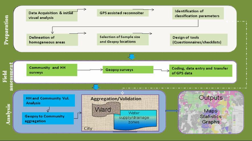
12
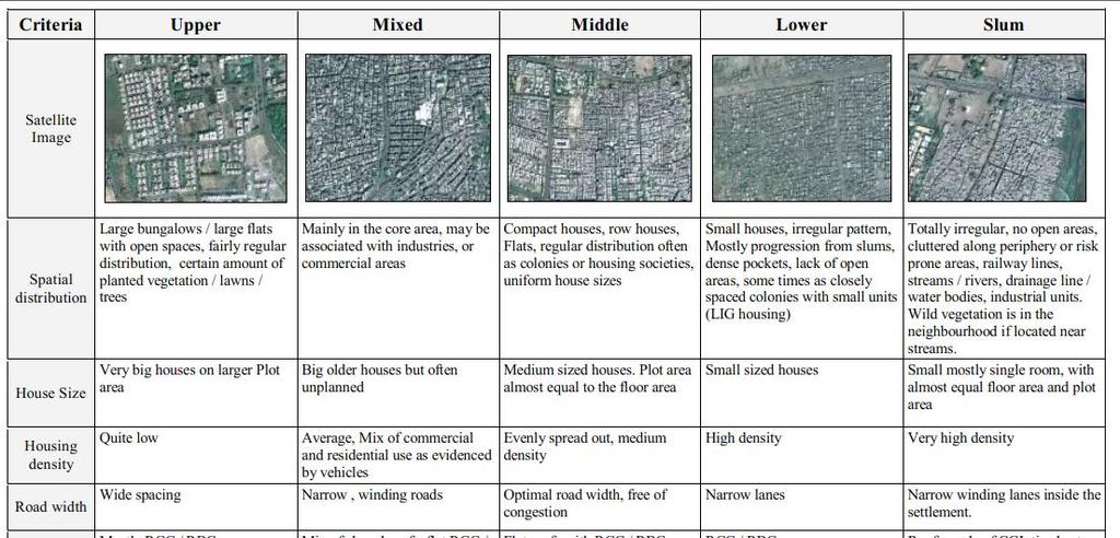
13 Area Typologies
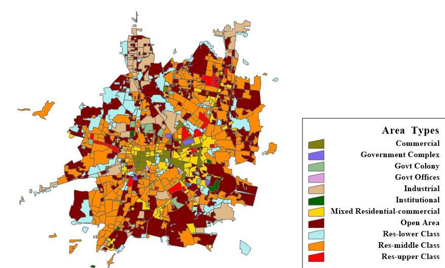

14 Area typologies & Geopsy samples
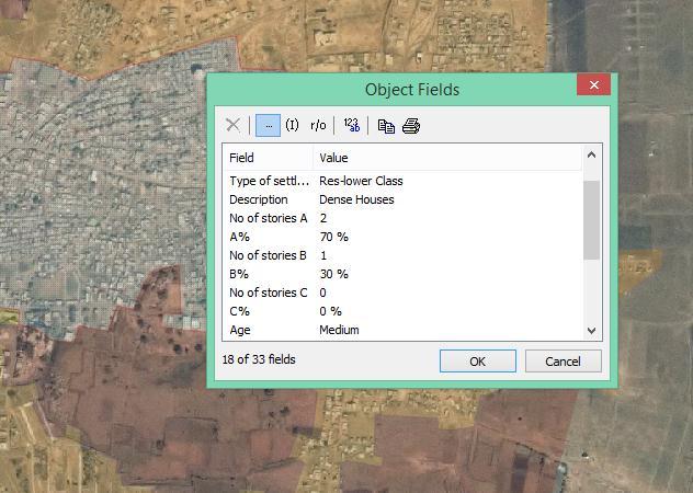
15 Area Attributes
16 GIS based spatial extrapolation process Reconnoiter to identify broad typologies Area categorization based on density, roof type, texture etc. to extract objects of similar characters as proxy to SECs. Homogeneous Polygons delineated. Ground-truthing and collection of details of use, number of stories, SECs, % open area etc. Build attribute table of polygons Geopsy (small street level areas) used as samples to probe further. Spatial extrapolation from geopsy to polygon based on area Multi-parameter Spatial Sql will be used for aggregation based on typologies of objects.

17 Capacity- Vulnerability Indices: Urban Households
18 City estimates from GIS analysis
19 Possible options to build Urban Resilience Incorporating lessons from disasters (Surat vs Delhi) Anticipatory culture necessary especially at ULB level What population? What risks? What needs to be done? Taking control over resources (local and distant) when grids fail, it is local resources that can save us (Water, energy micro grids) Building synergy across sectors and scales Households>Colonies> Wards>City; Water, waste, Storm water, energy, transport etc.. Planned redundancy across scales (not household level mini-utilities alone to manage water/energy crisis) Mutually reinforcing systems starting from household>colony>city levels (Rainwater, sewage recycling): subsidiarity principle for managing services Paradigm shift to address emerging issues: From Landuse to Network planning Waste not want not: Urban metabolism as framework for management of resources and wastes Access to Knowledge, Real time Information, forecasting networks (Early warning systems)
20 Context Approach to Resilience: Triple Loop Learning Frame of Reference Actions Results (E) Triple Loop Learning Policy level changes to manage water holistically including: Devolving roles to colonies/rwas; community level Decentralized treatment recycling Community scale water purification for urban poor, Public lands for water infrastructure related Double Loop Learning Developing alternate sources( Ground water, Rain water harvesting), leak reduction etc. Single Loop Learning More Capital works: (WTPs, OHTs, Network Expansion) 29JAN2013 DSDS: Lessons from Indore and Surat 20


21 Natural Resource Management Disaster Risk Management and Climate Change Urban Development Scenario Planning and Strategy Development Governance Water Supply and Sanitation Social Development Communications Gurgaon 424 Qutab Plaza DLF City Phase I Gurgaon India Phone Fax Over two decades of unique consulting to bridge Science, Institutions and Society Interface TARU Leading Edge Pvt Ltd Gandhinagar Plot No. 541/2 Sector 8 Gandhinagar India Phone Fax info@taru.org
Overview of proposed approach to the Desktop Study to inform discussion
 LTAS Phase 2: Climate Change Implications for the Human Settlements sector in South Africa Overview of proposed approach to the Desktop Study to inform discussion Project Team Project Lead: Crispian Olver
Together towards a Sustainable Urban Agenda
 Together towards a Sustainable Urban Agenda The City We (Youth) Want Preliminary findings from youth consultations Areas Issue Papers Policy Units 1.Social Cohesion and Equity - Livable Cities 2.Urban
CLIMATE RESILIENT ALTITUDINAL GRADIENTS (CRAGs)
") CLIMATE RESILIENT ALTITUDINAL GRADIENTS (CRAGs) BUILDING CLIMATE CHANGE RESILIENCE IN THE KIVU- RUSIZI WATERSHEDS Great Lake Conference Entebbe 2017 Chris Magero WHAT ARE CRAGs? Climate-Resilient Altitudinal
CLIMATE RESILIENT ALTITUDINAL GRADIENTS (CRAGs) BUILDING CLIMATE CHANGE RESILIENCE IN THE KIVU- RUSIZI WATERSHEDS Great Lake Conference Entebbe 2017 Chris Magero WHAT ARE CRAGs? Climate-Resilient Altitudinal
INTEGRATING CLIMATE VULNERABILITY & RISK ASSESSMENT INTO URBAN SPATIAL PLANNING PROCESS
 INTEGRATING CLIMATE VULNERABILITY & RISK ASSESSMENT INTO URBAN SPATIAL PLANNING PROCESS (CASE STUDY: BLITAR CITY, EAST JAVA, INDONESIA) SHINTA MICHIKO PUTERI, ST, MT. DR. IR. DENNY ZULKAIDI, MUP. WRITER
Measuring Disaster Risk for Urban areas in Asia-Pacific
 Measuring Disaster Risk for Urban areas in Asia-Pacific Acknowledgement: Trevor Clifford, Intl Consultant 1 SDG 11 Make cities and human settlements inclusive, safe, resilient and sustainable 11.1: By
Use of Climate information in Disaster Risk Management in Zimbabwe
 Use of Climate information in Disaster Risk Management in Zimbabwe WMO Regional Technical Meeting & User/CONOPS Workshop, 28 th October 2015 Lameck Betera Department of Civil Protection Institutional Arrangements
2 nd Semester. Core Courses. C 2.1 City and Metropolitan Planning. Module 1: Urban Structure and Growth Implications
 2 nd Semester Core Courses C 2.1 City and Metropolitan Planning Module 1: Urban Structure and Growth Implications Growth of cities; cities as engine of growth; urban sprawl; land value, economic attributes
Vulnerability and Adaptation to Climate Change
 Vulnerability and Adaptation to Climate Change Prof. Dr. Christoph Görg Department of Social Sciences, University of Kasssel Head of Department Environmental Politics, UFZ Leipzig 1 Introduction: Climate
Understanding Weather and Climate Risk. Matthew Perry Sharing an Uncertain World Conference The Geological Society, 13 July 2017
 Understanding Weather and Climate Risk Matthew Perry Sharing an Uncertain World Conference The Geological Society, 13 July 2017 What is risk in a weather and climate context? Hazard: something with the
A Review of Concept of Peri-urban Area & Its Identification
 A Review of Concept of Peri-urban Area & Its Identification Ar. Manita Saxena Research Scholar Department of Architecture and Planning M.A.N.I.T, Bhopal Dr. Supriya Vyas Assistant Professor, Department
Disaster Prevention and Management in Asia: The Context of Human Security and Its Relevance to Infrastructure Planning and Management
 Disaster Prevention and Management in Asia: The Context of Human Security and Its Relevance to Infrastructure Planning and Management Rajib Shaw http://www.iedm.ges.kyoto-u.ac.jp/ Contents Background and
This table connects the content provided by Education Perfect to the NSW Syllabus.
 Education Perfect Geography provides teachers with a wide range of quality, engaging and innovative content to drive positive student learning outcomes. Designed by teachers and written by our in-house
Disaster Risk Assessment: Opportunities for GIS and data management with Open DRI
 Disaster Risk Assessment: Opportunities for GIS and data management with Open DRI Jacob Opadeyi Department of Geomatics Engineering and Land Management, The University of the West Indies, St. Augustine,
They include earthquakes, volcanic eruptions, floods, landslides, and other processes and occurrences. They are included in the broader concept of.
 They include earthquakes, volcanic eruptions, floods, landslides, and other processes and occurrences. They are included in the broader concept of. In general, natural processes are labeled hazardous only
Global Atmospheric Circulation. Past climate change and natural causes. Global climate change and human activity
 GCSE Geography Edexcel B Revision Checklist Paper 1. Global Geographical Issues Topic 1. Hazardous Earth Key Idea I know/ understand The world s climate system Global Atmospheric Circulation Past climate
Topic 4: Changing cities
 Topic 4: Changing cities Overview of urban patterns and processes 4.1 Urbanisation is a global process a. Contrasting trends in urbanisation over the last 50 years in different parts of the world (developed,
Rural Regional Innovation: A response to metropolitan-framed placed-based thinking in the United States Brian Dabson
 Rural Regional Innovation: A response to metropolitan-framed placed-based thinking in the United States Brian Dabson Community & Regional Development Institute Cornell University Regional Research Roundtable
West Carroll Parish Hazard Mitigation Plan Update Public Meeting. August 25, 2015 Oak Grove, LA
 West Carroll Parish Hazard Mitigation Plan Update Public Meeting August 25, 2015 Oak Grove, LA Agenda Hazard Mitigation Planning Process SDMI Staff Risk Assessment SDMI Staff Update on Previous/Current
Foundation Geospatial Information to serve National and Global Priorities
 Foundation Geospatial Information to serve National and Global Priorities Greg Scott Inter-Regional Advisor Global Geospatial Information Management United Nations Statistics Division UN-GGIM: A global
Vulnerability of Bangladesh to Cyclones in a Changing Climate
 Vulnerability of Bangladesh to Cyclones in a Changing Climate Susmita Dasgupta Kiran Pandey Mainul Huq Zahirul Huq Khan M.M. Zahid Ahmed Nandan Mukherjee Malik Fida Khan 2010 Bangladesh: Tropical Cyclone
Local EPM Implementation Process in 5 stages
 Local PM Implementation Process in 5 stages 3. Working groups 1. City nvironmental Profile/ Outlook 5. Consolidation & Institutionalisation 4. Strategy & Action plans 2. City Consultation Urban nvironmental
Bossier Parish Hazard Mitigation Plan Update Public Meeting. August 10, 2016 Bossier City, LA
 Bossier Parish Hazard Mitigation Plan Update Public Meeting August 10, 2016 Bossier City, LA Agenda Hazard Mitigation Planning Process SDMI Staff Risk Assessment SDMI Staff Update on Previous/Current Mitigation
M14/3/GEOGR/SP2/ENG/TZ0/XX/Q GEOGRAPHY STANDARD LEVEL PAPER 2. Monday 19 May 2014 (morning) 1 hour 20 minutes INSTRUCTIONS TO CANDIDATES
 1 hour 20 minutes INSTRUCTIONS TO CANDIDATES") M14/3/GEOGR/SP2/ENG/TZ0/XX/Q 22145203 GEOGRAPHY STANDARD LEVEL PAPER 2 Monday 19 May 2014 (morning) 1 hour 20 minutes INSTRUCTIONS TO CANDIDATES Do not open this examination paper until instructed to do
M14/3/GEOGR/SP2/ENG/TZ0/XX/Q 22145203 GEOGRAPHY STANDARD LEVEL PAPER 2 Monday 19 May 2014 (morning) 1 hour 20 minutes INSTRUCTIONS TO CANDIDATES Do not open this examination paper until instructed to do
What is Spatial Planning?
 Spatial Planning in the context of the Responsible Governance of Tenure What is Spatial Planning? Text-only version This course is funded by the European Union through the EU-FAO Improved Global Governance
Switching to AQA from Edexcel: Draft Geography AS and A-level (teaching from September 2016)
") Switching to AQA from Edexcel: Draft Geography AS and A-level (teaching from September 2016) If you are thinking of switching from OCR to AQA (from September 2016), this resource is an easy reference guide.
Switching to AQA from Edexcel: Draft Geography AS and A-level (teaching from September 2016) If you are thinking of switching from OCR to AQA (from September 2016), this resource is an easy reference guide.
Advancing Geoscientific Capability. Geological Survey of Finland
 Advancing Geoscientific Capability Geological Survey of Finland GTK in brief The Geological Survey of Finland (GTK) is one of the largest European centres of excellence in assessment, research and the
European spatial policy and regionalised approaches
 Findings of the ESPON 2006 Programme COMMIN Final Conference 26-27 April 2007 European spatial policy and regionalised approaches by Dr. Kai BöhmeB ! Territory matters Structure of presentation! Territorial
CHAPTER 4 HIGH LEVEL SPATIAL DEVELOPMENT FRAMEWORK (SDF) Page 95
 Page 95") CHAPTER 4 HIGH LEVEL SPATIAL DEVELOPMENT FRAMEWORK (SDF) Page 95 CHAPTER 4 HIGH LEVEL SPATIAL DEVELOPMENT FRAMEWORK 4.1 INTRODUCTION This chapter provides a high level overview of George Municipality s
CHAPTER 4 HIGH LEVEL SPATIAL DEVELOPMENT FRAMEWORK (SDF) Page 95 CHAPTER 4 HIGH LEVEL SPATIAL DEVELOPMENT FRAMEWORK 4.1 INTRODUCTION This chapter provides a high level overview of George Municipality s
Department of Geography: Vivekananda College for Women. Barisha, Kolkata-8. Syllabus of Post graduate Course in Geography
 India: Regional Problems and Resource management Module 11 (Full Marks 50) Unit I: Region and Regionalisation 1.1 Various bases of regionalisation of India; problems of identification and delineation.
Climate Science to Inform Climate Choices. Julia Slingo, Met Office Chief Scientist
 Climate Science to Inform Climate Choices Julia Slingo, Met Office Chief Scientist Taking the planet into uncharted territory Impacts of climate change will be felt most profoundly through hazardous weather
New approaches to warning: the role of radar
 New approaches to warning: the role of radar John Handmer Centre for Risk and Community Safety, RMIT University Today The risk we want to reduce, and how much impact can we have on the risk of disasters?
Business Preparedness and Hurricane Risk
 Business Preparedness and Hurricane Risk Hurricanes are one of the more predictable natural disasters compared to events such as earthquakes, wildfires and tornadoes. Meteorologists gather data to predict
Thoughts toward autonomous land development. Introduction
 Thoughts toward autonomous land development Spatial Transformation of Regular grid Irrigation Frameworks Bangkok and Cairo A Work in Progress Information based on student workshop June 2009 and earlier
Tackling urban sprawl: towards a compact model of cities? David Ludlow University of the West of England (UWE) 19 June 2014
 19 June 2014") Tackling urban sprawl: towards a compact model of cities? David Ludlow University of the West of England (UWE) 19 June 2014 Impacts on Natural & Protected Areas why sprawl matters? Sprawl creates environmental,
Tackling urban sprawl: towards a compact model of cities? David Ludlow University of the West of England (UWE) 19 June 2014 Impacts on Natural & Protected Areas why sprawl matters? Sprawl creates environmental,
RCOF Review [Regional Climate Outlook Forum for the Gulf of Guinea region of Africa - PRESAGG] Status Report
![RCOF Review [Regional Climate Outlook Forum for the Gulf of Guinea region of Africa - PRESAGG] Status Report](/thumbs/78/77466191.jpg "RCOF Review [Regional Climate Outlook Forum for the Gulf of Guinea region of Africa - PRESAGG] Status Report") RCOF Review 2017 [Regional Climate Outlook Forum for the Gulf of Guinea region of Africa - PRESAGG] Status Report Specific Climate features of concerned region This region typically covers the area below
RCOF Review 2017 [Regional Climate Outlook Forum for the Gulf of Guinea region of Africa - PRESAGG] Status Report Specific Climate features of concerned region This region typically covers the area below
PURR: POTENTIAL OF RURAL REGIONS UK ESPON WORKSHOP Newcastle 23 rd November Neil Adams
 PURR: POTENTIAL OF RURAL REGIONS UK ESPON WORKSHOP Newcastle 23 rd November 2012 Neil Adams PURR: Potential of Rural Regions Introduction Context for the project A spectrum of knowledge Rural Potentials
ACCESSIBILITY TO SERVICES IN REGIONS AND CITIES: MEASURES AND POLICIES NOTE FOR THE WPTI WORKSHOP, 18 JUNE 2013
 ACCESSIBILITY TO SERVICES IN REGIONS AND CITIES: MEASURES AND POLICIES NOTE FOR THE WPTI WORKSHOP, 18 JUNE 2013 1. Significant differences in the access to basic and advanced services, such as transport,
TOWARDS CLIMATE-RESILIENT COASTAL MANAGEMENT: OPPORTUNITIES FOR IMPROVED ICZM IN BELIZE
 TOWARDS CLIMATE-RESILIENT COASTAL MANAGEMENT: OPPORTUNITIES FOR IMPROVED ICZM IN BELIZE CHANTALLE SAMUELS Coastal Zone Management Authority and Institute The Caribbean Community Climate Change Centre VULNERABILITY
World Meteorological Organization
 World Meteorological Organization Opportunities and Challenges for Development of Weather-based Insurance and Derivatives Markets in Developing Countries By Maryam Golnaraghi, Ph.D. Head of WMO Disaster
ENSURE. Coordinator: Hormoz MODARESSI Website:
 ENSURE Coordinator: Hormoz MODARESSI h.modaressi@brgm.fr Website: http://ensureproject.eu/ The project is financed by the European Commission under the 7th Framework Programme for Research and Technological
Drought lesson plan ITEMS. Teachers lesson plan. Student assignments. About droughts. Real life stories. Droughts: Be prepared.
 Drought lesson plan The drought lesson plan provides teachers and students with an opportunity to investigate the Australian climate, water table and the impacts of drought through individual or classroom
Dar es Salaam - Reality Check Workshop
 Dar es Salaam - Reality Check Workshop hosted by GIZ and Dar es Salaam City Council Introduction: Key Urban Characteristics of Dar es Salaam Challenges and Opportunities for Resilient Development in the
The Spatial Perspective
 Department of Geography University of California at Santa Barbara GEOGRAPHY 5 MIDTERM REVIEW SHEET The Spatial Perspective - Review all of chapter 1 carefully except for Box 1.B (but do review Box 1.A
Presentation by Thangavel Palanivel Senior Strategic Advisor and Chief Economist UNDP Regional Bureau for Asia-Pacific
 Presentation by Thangavel Palanivel Senior Strategic Advisor and Chief Economist UNDP Regional Bureau for Asia-Pacific The High-Level Euro-Asia Regional Meeting on Improving Cooperation on Transit, Trade
INDIANA ACADEMIC STANDARDS FOR SOCIAL STUDIES, WORLD GEOGRAPHY. PAGE(S) WHERE TAUGHT (If submission is not a book, cite appropriate location(s))
 WHERE TAUGHT (If submission is not a book, cite appropriate location(s))") Prentice Hall: The Cultural Landscape, An Introduction to Human Geography 2002 Indiana Academic Standards for Social Studies, World Geography (Grades 9-12) STANDARD 1: THE WORLD IN SPATIAL TERMS Students
Prentice Hall: The Cultural Landscape, An Introduction to Human Geography 2002 Indiana Academic Standards for Social Studies, World Geography (Grades 9-12) STANDARD 1: THE WORLD IN SPATIAL TERMS Students
West Baton Rouge Parish Hazard Mitigation Plan Update Public Meeting. September 9, 2015 Port Allen, LA
 West Baton Rouge Parish Hazard Mitigation Plan Update Public Meeting September 9, 2015 Port Allen, LA Agenda Hazard Mitigation Planning Process SDMI Staff Risk Assessment SDMI Staff Update on Previous/Current
A Framework for the Study of Urban Health. Abdullah Baqui, DrPH, MPH, MBBS Johns Hopkins University
 This work is licensed under a Creative Commons Attribution-NonCommercial-ShareAlike License. Your use of this material constitutes acceptance of that license and the conditions of use of materials on this
Enquiry question: How does the world s climate system function, why does it change and how can this be hazardous for people?
 Content Topic 1: Hazardous Earth Enquiry question: How does the world s climate system function, why does it change and how can this be hazardous for people? 1.1 The atmosphere operates as a global system
Summary and Conclusions
 241 Chapter 10 Summary and Conclusions Kerala is situated in the southern tip of India between 8 15 N and 12 50 N latitude and 74 50 E and 77 30 E longitude. It is popularly known as Gods own country.
Identification of vulnerable areas in municipal corporation of Greater Mumbai due to extreme events based on socio economic indicators
 Indian Journal of Geo-Marine Sciences Vol. 42 (7), November 2013, pp. 907-914 Identification of vulnerable areas in municipal corporation of Greater Mumbai due to extreme events based on socio economic
WORLD COUNCIL ON CITY DATA
 WORLD COUNCIL ON CITY DATA WCCD ISO 37120 STANDARDIZED CITY DATA TO MEET UN SDG TARGETS UN WORLD DATA FORUM Presented by: James Patava www.dataforcities.org @wccitydata PUBLICATION OF THE FIRST ISO STANDARD
Impact on Agriculture
 Weather Variability and the Impact on Agriculture InfoAg 2017 Copyright 2017, awhere. All Rights Reserved The Problem: The Earth s Atmosphere is a Heat Engine In transition 1 C warming of atmosphere Triples
World Geography. WG.1.1 Explain Earth s grid system and be able to locate places using degrees of latitude and longitude.
 Standard 1: The World in Spatial Terms Students will use maps, globes, atlases, and grid-referenced technologies, such as remote sensing, Geographic Information Systems (GIS), and Global Positioning Systems
Predict. Perform. Profit. Highly accurate rain forecasts a missing link to Climate Resilient Agriculture in West Africa
 Predict. Perform. Profit. Highly accurate rain forecasts a missing link to Climate Resilient Agriculture in West Africa Presentation for Food Security Working Group 9 May 2017 Climate Change & Food Security
SEASONAL CLIMATE OUTLOOK VALID FOR JULY-AUGUST- SEPTEMBER 2013 IN WEST AFRICA, CHAD AND CAMEROON
 SEASONAL CLIMATE OUTLOOK VALID FOR JULY-AUGUST- SEPTEMBER 2013 IN WEST AFRICA, CHAD AND CAMEROON May 29, 2013 ABUJA-Federal Republic of Nigeria 1 EXECUTIVE SUMMARY Given the current Sea Surface and sub-surface
Dr.Sinisa Vukicevic Dr. Robert Summers
 Dr.Sinisa Vukicevic Dr. Robert Summers "Planning" means the scientific, aesthetic, and orderly disposition of land, resources, facilities and services with a view to securing the physical, economic and
Land Accounts - The Canadian Experience
 Land Accounts - The Canadian Experience Development of a Geospatial database to measure the effect of human activity on the environment Who is doing Land Accounts Statistics Canada (national) Component
Georeferencing and Satellite Image Support: Lessons learned, Challenges and Opportunities
 Georeferencing and Satellite Image Support: Lessons learned, Challenges and Opportunities Shirish Ravan shirish.ravan@unoosa.org UN-SPIDER United Nations Office for Outer Space Affairs (UNOOSA) UN-SPIDER
Disaster Risk Management in India. Kamal Kishore New Delhi, 27 October 2016
 Disaster Risk Management in India Kamal Kishore New Delhi, 27 October 2016 Hazard, Exposure and Vulnerability Disaster Prevention Mitigation Hurricane Matthew: Cuba & Haiti Emergency Response Coordination
CAN THO URBAN DEVELOPMENT AND RESILIENCE PROJECT
 CAN THO URBAN DEVELOPMENT AND RESILIENCE PROJECT 1 Phnom Penh Can Tho City HCM City EAST SEA 2 1 3 Highest Water Level WATER LEVEL RAISE IN CAN THO DURING LAST 40 YEARS 4 2 Land subsidence a threat that
TOOLS FOR RISK MANAGEMENT Related to climate change
 TOOLS FOR RISK MANAGEMENT Related to climate change copyright CONTENT 1 CLIMATE CHANGE AND ENVIRONMENTAL STUDIES 2 METHODS AND TOOLS DEVELOPED BY EGIS For infrastructures For urban areas For crisis management
Analysis of travel-to-work patterns and the identification and classification of REDZs
 Analysis of travel-to-work patterns and the identification and classification of REDZs Dr David Meredith, Teagasc, Spatial Analysis Unit, Rural Economy Development Programme, Ashtown, Dublin 15. david.meredith@teagasc.ie
Assessing Hazards and Risk
 Page 1 of 6 EENS 204 Tulane University Natural Disasters Prof. Stephen A. Nelson Assessing Hazards and Risk This page last updated on 07-Jan-2004 As discussed before, natural disasters are produced by
Climate Change in Newfoundland & Labrador
 Climate Change in Newfoundland & Labrador Impacts and Adaptation Newleef Conference 08 October 2015 Met-Ocean Services The Team 55 personnel; 24/7 operational weather forecast desk; Equipment technician
DROUGHT ASSESSMENT USING SATELLITE DERIVED METEOROLOGICAL PARAMETERS AND NDVI IN POTOHAR REGION
 DROUGHT ASSESSMENT USING SATELLITE DERIVED METEOROLOGICAL PARAMETERS AND NDVI IN POTOHAR REGION Researcher: Saad-ul-Haque Supervisor: Dr. Badar Ghauri Department of RS & GISc Institute of Space Technology
Geospatial Technologies for Resources Planning & Management
 Geospatial Technologies for Resources Planning & Management Lal Samarakoon, PhD Director, Geoinformatics Center Asian Institute of Technology, Thailand Content Geoinformatics for SDG Information Integration
ANALYSING THE DIVERSITY OF DEPRIVED AREAS IN MUMBAI, INDIA
 ANALYSING THE DIVERSITY OF DEPRIVED AREAS IN MUMBAI, INDIA MONIKA KUFFER (M.KUFFER@UTWENTE.NL) KARIN PFEFFER, RICHARD SLIUZAS, ISA BAUD, MARTIN VAN MAARSEVEEN Source: Google Earth CONTENT OF PRESENTATION
International Guidelines on Access to Basic Services for All
 International Guidelines on Access to Basic Services for All Presentation and initials lessons from implementation Accessibility to services in regions and cities : measures and policies, OECD 18 June
Use of Geospatial data for disaster managements
 Use of Geospatial data for disaster managements Source: http://alertsystemsgroup.com Instructor : Professor Dr. Yuji Murayama Teaching Assistant : Manjula Ranagalage What is GIS? A powerful set of tools
Low Density Areas : Places of Opportunity. Enrique Garcilazo, OECD Directorate for Public Governance and Territorial Development
 Low Density Areas : Places of Opportunity Enrique Garcilazo, OECD Directorate for Public Governance and Territorial Development Open Days, Brussels, 11 th October, 2016 Outline 1. Performance low density
Extreme Weather Events: Infrastructure Damage and Impact on Vulnerable Populations
 Extreme Weather Events: Infrastructure Damage and Impact on Vulnerable Populations Cindy L. Parker MD, MPH Physicians for Social Responsibility Johns Hopkins Bloomberg School of Public Health 1 Climate
OCR 2008 AS and A level Geography Specification Mapping Guide
 OCR 2008 AS and A level Geography Specification Mapping Guide Contents Introduction Error! Bookmark not defined. Specification map: 2008 OCR AS and A level Geography 3 What's new? 10 Introduction This
Global Challenges - Partnering with Service Providers. World Meteorological Organization. J. Lengoasa WMO Deputy Secretary-General
 WMO World Meteorological Organization Working together in weather, climate and water Global Challenges - Partnering with Service Providers J. Lengoasa WMO Deputy Secretary-General jlengoasa@wmo.int http://www.wmo.int/pages/gfcs/gfcs_en.html
By Lillian Ntshwarisang Department of Meteorological Services Phone:
 By Lillian Ntshwarisang Department of Meteorological Services Phone: +267 3612200 Email: lntshwarisang@gov.bw/ lntshwarisang@gmail.com Introduction Mandate of DMS Function of the Department Services to
Economic consequences of floods: impacts in urban areas
 Economic consequences of floods: impacts in urban areas SWITCH Paris Conference Paris, 24 th 26 th January 2011 Economic consequences of floods: impacts in urban areas Institutions: Authors Vanessa Cançado
From Vulnerability to Resilience And the Tools to Get There. Out of Harm s Way Partnership for the Delaware Estuary August 1, 2012
 From Vulnerability to Resilience And the Tools to Get There Out of Harm s Way Partnership for the Delaware Estuary August 1, 2012 Today s Presentation Tour of New Jersey Challenges Definitions so we re
Semester: Two. Study Hours: 28 contact/80 independent BSU Credits: 10 ECTS: 5
 BATH SPA UNIVERSITY Erasmus, exchange & study abroad module catalogue Geography: semester 2 Modules at Bath Spa University are usually worth either 10, 20 or 40 credits. If you are using the European Credit
How advances in atmospheric modelling are used for improved flood forecasting. Dr Michaela Bray Cardiff University
 How advances in atmospheric modelling are used for improved flood forecasting Dr Michaela Bray Cardiff University Overview of current short term rainfall forecasting Advancements and on going research
Governance and Urban Nexus: Closing the gaps
 Governance and Urban Nexus: Closing the gaps Donovan Storey Chief, Sustainable Urban Development, Environment & Development Division National Dialogue on Urban Nexus in Thailand Bangkok, UNCC, 19 March
Storm Surge/Coastal Inundation State of the Union. Jamie Rhome Storm Surge Team Lead NOAA/National Hurricane Center
 Storm Surge/Coastal Inundation State of the Union Jamie Rhome Storm Surge Team Lead NOAA/National Hurricane Center 2 Tampa: Cat 5 Scenario 3 4 The Stakes are High Combination of SLR and increasing coastal
Paul Bridge Meteorologist Vaisala/UKMO Work Groups/Committees: WMO/TRB/AMS
 Paul Bridge Meteorologist Vaisala/UKMO Work Groups/Committees: WMO/TRB/AMS Introduction (a) Identify and establish, if possible, inventories of transport networks in the ECE region which are vulnerable
Assessing Social Vulnerability to Biophysical Hazards. Dr. Jasmine Waddell
 Assessing Social Vulnerability to Biophysical Hazards Dr. Jasmine Waddell About the Project Built on a need to understand: The pre-disposition of the populations in the SE to adverse impacts from disaster
Reducing Vulnerability to Extreme Heat: Science-Policy Interface
 Reducing Vulnerability to Extreme Heat: Science-Policy Interface Olga Wilhelmi, Mary Hayden, Jennifer Boehnert, Ursula Lauper and SIMMER research team October 23, 2013 Toronto SIMMER workshop Science-Policy
Ms. Latoya Regis. Meteorologist Hydrometeorological Service, Guyana
 Ms. Latoya Regis Meteorologist Hydrometeorological Service, Guyana Background Ninety percent (90%) of Guyana s population resides along the (Atlantic) Coast, which is below mean sea level and accounts
Disaster Management & Recovery Framework: The Surveyors Response
 Disaster Management & Recovery Framework: The Surveyors Response Greg Scott Inter-Regional Advisor Global Geospatial Information Management United Nations Statistics Division Department of Economic and
Chapter 10 Human Settlement Geography Book 1 Class 12
 CHAPTER 10 HUMAN SETTLEMENTS 1. RURAL, SUB URBAN AND URBAN SETTLEMENTS: This classification is common worldwide but the criteria differ from country to country. 5. Criteria for classification differs from
The inland water related tourism in South Africa by 2030 in the light of global change
 The inland water related tourism in South Africa by 2030 in the light of global change KSA 2 Water-Linked Ecosystems T4: Green economy and sustainable (green) innovations K5/2620 How can natural capital
SUPPORTS SUSTAINABLE GROWTH
 DDSS BBUUN NDDLLEE G E O S P AT I A L G O V E R N A N C E P A C K A G E SUPPORTS SUSTAINABLE GROWTH www.digitalglobe.com BRISBANE, AUSTRALIA WORLDVIEW-3 30 CM International Civil Government Programs US
The ESPON Programme. Goals Main Results Future
 The ESPON Programme Goals Main Results Future Structure 1. Goals Objectives and expectations Participation, organisation and networking Themes addressed in the applied research undertaken in ESPON projects
16540/14 EE/cm 1 DG E 1A
 Council of the European Union Brussels, 5 December 2014 (OR. en) 16540/14 ENV 965 CULT 139 NOTE From: To: Subject: General Secretariat of the Council Delegations Charter of Rome on Natural and Cultural
Designing smart & Resilient cities:
 Designing smart & Resilient cities: How can Egyptian cities learn from an emerging global practice On the Cuspof Change Professor Samer Bagaeen FRICS MRTPI FRSA AoU 1. GLOBAL CHALLENGES POPULATION GROWTH,
Making space for a more foundational construction sector in Brussels
 Making space for a more foundational construction sector in Brussels Sarah De Boeck, David Bassens & Michael Ryckewaert Social innovation in the Foundational Economy Cardiff, 5 th of September 2018 1.
Challenges of Urbanisation & Globalisation
 Challenges of Urbanisation & Globalisation Prepared by: Khairul Hisyam Kamarudin, PhD Feb 2016 Based on original lecture note by: Wan Nurul Mardiah Wan Mohd Rani, PhD URBANIZATION What is Urbanization?
Climate and Health Vulnerability & Adaptation Assessment Profile Manaus - Brazil
 Climate and Health Vulnerability & Adaptation Assessment Profile Manaus - Brazil Christovam Barcellos (ICICT/Fiocruz) Diego Xavier Silva (ICICT/Fiocruz) Rita Bacuri (CPqLMD/Fiocruz) Assessment Objectives
Flood management in Namibia: Hydrological linkage between the Kunene River and the Cuvelai Drainage System: Cuvelai-Etosha Basin
 Flood management in Namibia: Hydrological linkage between the Kunene River and the Cuvelai Drainage System: Cuvelai-Etosha Basin By: Leonard Hango Department of Water Affairs and Forestry Ministry of Agriculture
SECTION II Hydrological risk
 Chapter 3 Understanding disaster risk: hazard related risk issues SECTION II Hydrological risk Peter Salamon Coordinating lead author Hannah Cloke Lead author 3.4 Giuliano di Baldassarre Owen Landeg Florian
Md. Shahidul ISLAM Assistant Professor Department of Disaster Science and Management University of Dhaka, Bangladesh 12 December 2016 Nepal
 On the Spot Identification of Flood Inundation Depth from Gridded Data using GPS enabled Smartphone Application to help People fix Plinth Levels of their Houses Md. Shahidul ISLAM Assistant Professor Department
Poverty and Hazard Linkages
 Poverty and Hazard Linkages Global Risk Identification Programme Proposal Development Coordination Meeting Friday, 19 May 2006 CIESIN Earth Institute Columbia University www.ciesin.columbia.edu Data Improvements
Study of Changes in Climate Parameters at Regional Level: Indian Scenarios
 Study of Changes in Climate Parameters at Regional Level: Indian Scenarios S K Dash Centre for Atmospheric Sciences Indian Institute of Technology Delhi Climate Change and Animal Populations - The golden
COUNTRY PRESENTATION ON MR JAYNAL ABEDIN JOINT SECRETARY ( WORKS & DEVELOPMENT ) MINISTRY OF DEFENCE
 MINISTRY OF DEFENCE") COUNTRY PRESENTATION ON By MR JAYNAL ABEDIN JOINT SECRETARY ( WORKS & DEVELOPMENT ) MINISTRY OF DEFENCE Bangladesh Geographical Location of Bangladesh Bangladesh Country at a Glance Physical Features 1,230
COUNTRY PRESENTATION ON By MR JAYNAL ABEDIN JOINT SECRETARY ( WORKS & DEVELOPMENT ) MINISTRY OF DEFENCE Bangladesh Geographical Location of Bangladesh Bangladesh Country at a Glance Physical Features 1,230