Constantin Radu Gogu PROBLEME ACTUALE ALE GESTIONĂRII ŞI EXPLOATĂRII RESURSELOR DE APĂ SUBTERANĂ. Universitatea Tehnica de Constructii Bucuresti
|
|
|
- Estella Cobb
- 5 years ago
- Views:
Transcription
1 Platforma informatica pentru integrarea informatiei hidrogeologice de detaliu pentru mediile sedimentare in vederea obtinerii unui model hidrogeologic 3D Constantin Radu Gogu PROBLEME ACTUALE ALE GESTIONĂRII ŞI EXPLOATĂRII RESURSELOR DE APĂ SUBTERANĂ Universitatea Tehnica de Constructii Bucuresti Bucuresti, 29 Octombrie, 2008
2 Continut : - Motivatie - Obiective - Tendinte actuale la nivel mondial - Platforma de modelare - Structura bazei de date hidrogeologica - Stadiul actual & dezvoltarea in prezent - Concluzii & Discutii
3 Motivatie Modelarea detaliata a mediilor sedimentare (medii aluvionare, medii deltaice, etc.) ce formeaza acvifere importante este foarte complexa din doua motive: 1. Heterogeneitatea naturala intrinseca a mediului geologic 2. Instrumentele de gestiune a datelor (ce manipuleaza datele geologice si hidrogeologice) necesare pentru modelele hidrogeologice, nu sunt indeajuns dezvoltate.
4 Obiective Model conceptual iterativ 1. Gestiunea datelor hidrogeologice a. Definirea modelului conceptual hidrogeologic b. Vizualizarea datelor c. Pre-procesarea datelor hidrogeologice (inainte de model) 2. Modelarea 3D hidrogeologica a. Dezvoltarea si aplicarea tehnicilor de caracterizare geologica 3D pentru mediile sedimentare b. Dezvoltarea tehnicilor de parametrizare hidraulica pentru modelele geologice 3D in mediul sedimentar c. Definirea modelului hidrogeologic conceptual / heterogeneitate tratarea datelor (interpretare, interpolare, geostatistica, modelare stohastica ) d. Generarea modelelor hidrogeologice 3D
5 Tendinte actuale - Baze de date spatiale Scheme de baze de date hidrogeologice spatiale existente Baza de date hidrogeologica HYGES: Universitatea din Liège (Gogu et al., 2001); ArcHydro: modelul de date hidrologic ESRI Universitatea din Texas (Maidment, 2002); Modelul hidrogeologic: ESRI, Strassberg, Teza de doctorat (Strassberg, 2006); baza de date GIS dezvoltata in Proiectul European WaterStrategyMan (ProGEA S.r.l, 2004); GABARDINE (Wojdaet al, 2006) Eforturi europene Directiva Europeana Cadru pentru Apa - document indrumator pentru implementarea elementelor GIS dezvoltate de grupul de lucru pentru informatie geospatiala (Vogt, 2002); INSPIRE (15 Mai 2007) initiativa incearca sa realizeze crearea unei infrastructuri de informatii spatiale Europene ce ofera utilizatorilor servicii informatice spatiale integrate. Aceste servicii trebuie sa permita utilizatorilor sa identifice si sa acceseze informatia spatiala sau geografica provenind din surse multiple, de la nivel local pana la nivel global, intr-un mod inter-operabil pentru o mare varietate de utilizatori
6 Tendinte actuale - Baze de date spatiale Standarde pentru transferul de date spatiale: Standardul National Australian pentru Transfer de Date Hidrogeologice (1999); - GML: Geography Markup Laguage, aflat in proces de stantardizare ca ISO (Cox et al., 2002; Lake, 2005); Scheme de aplicare pentru implementarea standardelor exprimate in limbaje mark-up : - XMML (exploration and Mining Markup Language): utilizand o schema de aplicare GML (Cox, 2001); - GeoSciML (Geo-Science Mark-up Language): utilizand o schema de aplicare GML pentru schimb de date geologice (Sen and Duffy, 2005); are ca scop pe termen scurt se reprezinte informatia geostiintifica legata de hartile si informatiile geologice. - stabileste un grup comun de features types (categorii) bazate pe criterii geologice (unitati, structuri, fosile, sau segmente ale investigatiilor geologice (sectiuni, specimene, masuratori).

7 Tendinte actuale - Baze de date spatiale GeoSciML (Geo-Science Mark-up Language): 1. Modelul de Date Geologic robust d.p.d.v. stiintific date atribut structurate bazat pe modelele existente Schema UML versiunea 1.1 Unitati geologice unitati litologice Materiale roci Structuri contacte, falii Vocabulare lookup tables, authority tables
, XMML, si alte scheme")
8 Tendinte actuale - Baze de date spatiale GeoSciML (Geo-Science Mark-up Language): 2. Codare GML extensie a XML Construit pe GML (Geographic Markup Language), XMML, si alte scheme standard
9 Tendinte actuale GeoSciML (Geo-Science Mark-up Language): - Baze de date spatiale «Type» GM_Object +shape 1 «FeatureType» SamplingFeature + responsible: CI_ResponsibleParty [0..1] +samplingframe 1 «FeatureType» MappedFeature «ObjectType» ControlledConcept +occurrence 0..* + preferredname: CharacterString Description +classifier 1 0..* 1 +specification PrimaryClassification +alternativeclassifier «CodeList» DescriptionPurpose «FeatureType» GeologicFeature AlternativeClassification + definingnorm: + instance: + typicalnorm: + age: GeologicAge [1..*] + physicalproperty: CGI_PhysicalDescription [0..*] + purpose: DescriptionPurpose = instance 0..* Map polygon 0..* Observational setting Legend item «FeatureType» GeologicUnit «FeatureType» GeologicStructure + genesis: CGI_TermValue [0..1]
10 Tendinte actuale - Baze de date spatiale GeoSciML (Geo-Science Mark-up Language): GML Links to other (Geography modelling Markup languages Language) O&M (Observations & Measurements) XMML Boreholes GeoSciML (Geoscience Markup Language)


: -")
11 Tendinte actuale GeoSciML (Geo-Science Mark-up Language): - Baze de date spatiale
12 Platforma de modelare 3D Geologic model validation Analysis G1 G2. Geologic model Gn realisations MODELING SOFTWARE 3D Hydrogeologic Model INTERFACE Geostatistical software Deterministic methods Interpretation Geospatial Database interface (Spatial/Time dependent query, visualization, and analysis tools) Initial Geological Data 3D Interpreted Geological Data 3D Geologic model Hydrogeological Data Hydrogeological Geospatial Database

13 Structura bazei de date hidrogeologica - Proiectare UML Design Schema Enterprise Architect Sparks Systems or Rational Rose IBM Export XMI Import using Case Tools Arc Catalog

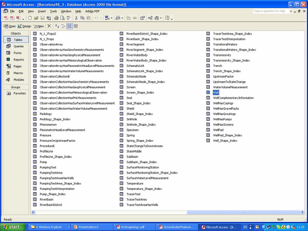
14 Structura bazei de date hidrogeologica - Continut

15 Structura bazei de date hidrogeologica - Continut

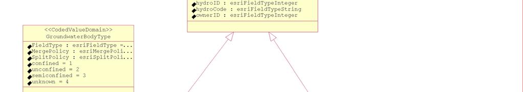

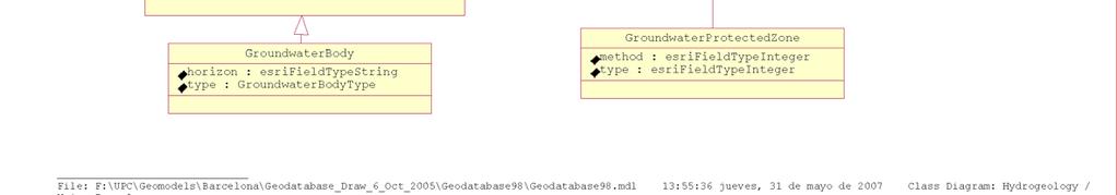
16 Structura bazei de date hidrogeologica Hydrogeology - Continut

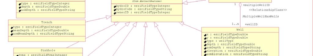
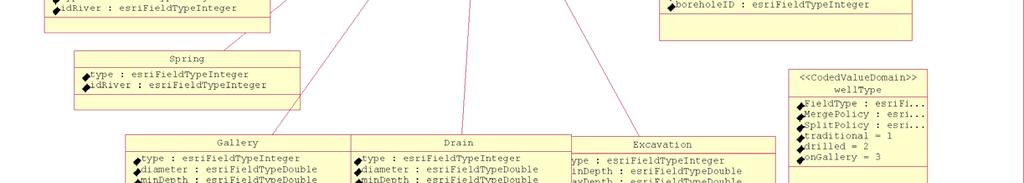
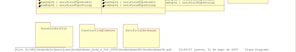
17 Structura bazei de date hidrogeologica Groundwater Features - Continut
18 Structura bazei de date hidrogeologica - Continut - Diverse probleme practice inatlnite - Identificatori diversi pentru acelasi put; - Puturi cu acelasi identificator pot avea coordonate diferite; - Valori piezometrice gresite; - Echivalenta intre parametrii hidrochimici masurati si unitatile de masura.

19 Structura bazei de date hidrogeologica - Stadiul actual - Instrumente de interogare si analiza a datelor

20 Structura bazei de date hidrogeologica - Stadiul actual - Hidrogeologie - Instrumente de interogare si analiza a datelor

21 Structura bazei de date hidrogeologica - Stadiul actual - Hidrogeologie - Instrumente de interogare si analiza a datelor
22 Structura bazei de date hidrogeologica - Stadiul actual - Geologie Instrumente de interogare si analiza a datelor Vizualizarea informatiilor lito-stratigrafice

23 Structura bazei de date hidrogeologica - Stadiul actual - Geologie Instrumente de interogare si analiza a datelor
24 Structura bazei de date hidrogeologica - Stadiul actual - Geologie Instrumente de interogare si analiza a datelor
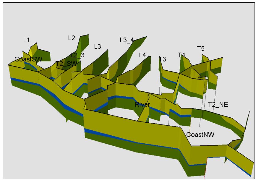
25 Structura bazei de date hidrogeologica - Stadiul actual - Geologie Instrumente de interogare si analiza a datelor Geologic profile generation
26 Structura bazei de date hidrogeologica - Stadiul actual - Geologie Instrumente de interogare si analiza a datelor
27 Structura bazei de date hidrogeologica - Stadiul actual - Geologie Instrumente de interogare si analiza a datelor
28 Stadiul actual & dezvoltare
29 Stadiul actual & dezvoltare
30 Stadiul actual & dezvoltare

31 -Geologie Stadiul actual & dezvoltare

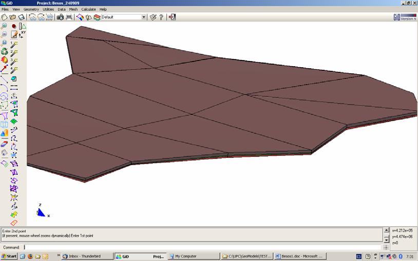
32 Stadiul actual & dezvoltare - Geologie Steps to 3D model

33 Stadiul actual & dezvoltare Parametrizare hidrogeologica


34 Stadiul actual & dezvoltare Parametrizare hidrogeologica
35 3D Geologic model validation Concluzii & Discutii Hydrogeological Modeling Software 3D Hydrogeological Modeling Software 3D Hydrogeologic Model Analysis G1 G2. Geologic model Gn realisations Geostatistical software Deterministic methods Interpretation Geospatial Database interface (Spatial/Time dependent query and visualization) Initial Geological Data 3D Interpreted Geological Data Output 3D Geologic models Hydrogeological Data Hydrogeological Geospatial Database Data capture & Export
36 Va multumesc pentru atentie!
Conceptual model of hydrogeological information for a GIS-based Decision Support System in management of artificial recharge in semi-arid regions
 Conceptual model of hydrogeological information for a GIS-based Decision Support System in management of artificial recharge in semi-arid regions P.Wojda 1, R. Gogu 3, S.Brouyère 1,2 1 Hydrogeology & Environmental
Current Trends and Approaches in Urban Hydrogeology
 Buletinul Ştiinţific al Universităţii "POLITEHNICA" din Timişoara Seria HIDROTEHNICA TRANSACTIONS on HYDROTECHNICS Tom 55(69), Fascicola 1, 2010 Current Trends and Approaches in Urban Hydrogeology Ioan
Pentru clasa a X-a Ştiinţele naturii-sem II
 Pentru clasa a X-a Ştiinţele naturii-sem II Reprezentarea algoritmilor. Pseudocod. Principiile programării structurate. Structuri de bază: structura liniară structura alternativă structura repetitivă Algoritmi
3D GEO-MODELS SHARING ON THE WEBSITE BASED ON GEOSCIML STANDARD
 3D GEO-MODELS SHARING ON THE WEBSITE BASED ON GEOSCIML STANDARD 1 WEIHUA HUA, 1 JINGJING DAI 1 Faculty of Information Engineering, China University of Geosciences, Wuhan 430074, Hubei, China ABSTRACT 3D
SDI Standards at work
 SDI Standards at work Jan Juul Jensen Senior Technology Strategist Informi GIS Denmark Informi GIS Private held Limited Company Specialized in GIS 100+ employees HQ in Charlottenlund, Copenhagen Regional
ECP-2007-GEO OneGeology-Europe. WP5: Informatics specification, data model, interoperability and standards
 ECP-2007-GEO-317001 OneGeology-Europe WP5: Informatics specification, data model, interoperability and standards D5.1 : Documented data model, thematic profile and guidance for GeoSciML Executive summary
AN APPROACH TO THE NONLINEAR LOCAL PROBLEMS IN MECHANICAL STRUCTURES
 U.P.B. Sci. Bull., Series D, Vol. 74, Iss. 3, 2012 ISSN 1454-2358 AN APPROACH TO THE NONLINEAR LOCAL PROBLEMS IN MECHANICAL STRUCTURES Marius-Alexandru GROZEA 1, Anton HADĂR 2 Acest articol prezintă o
UTILIZAREA UNUI GIS ÎN VEDEREA REZOLVĂRII PROBLEMELOR DE CADASTRU GENERAL ŞI DE SPECIALITATE PENTRU DEZVOLTAREA DURABILĂ A LOCALITĂŢILOR
 THE USE OF A GIS IN ORDER TO SOLVE THE PROBLEMS OF GENERAL LAND SURVEYING AND OF SPECIAL LAND SURVEYING FOR DEVELOPING THE SUISTAINABLE DEVELOPMENT OF THE TOWNS UTILIZAREA UNUI GIS ÎN VEDEREA REZOLVĂRII
Modelling the Steady State Characteristic of ph Neutralization Process: a Neuro-Fuzzy Approach
 BULETINUL Universităţii Petrol Gaze din Ploieşti Vol. LXVII No. 2/2015 79 84 Seria Tehnică Modelling the Steady State Characteristic of ph Neutralization Process: a Neuro-Fuzzy Approach Gabriel Rădulescu
NAG-City Expert Workshop Oslo 8-9. October 2012 SOSI standards and mapping for Europe (INSPIRE)
") NAG-City Expert Workshop Oslo 8-9. October 2012 SOSI standards and mapping for Europe (INSPIRE) Per Ryghaug, Geomatics The Norwegian national standard on geographic information - SOSI Started in 1984 NGU
NAG-City Expert Workshop Oslo 8-9. October 2012 SOSI standards and mapping for Europe (INSPIRE) Per Ryghaug, Geomatics The Norwegian national standard on geographic information - SOSI Started in 1984 NGU
COMPARATIVE DISCUSSION ABOUT THE DETERMINING METHODS OF THE STRESSES IN PLANE SLABS
 74 COMPARATIVE DISCUSSION ABOUT THE DETERMINING METHODS OF THE STRESSES IN PLANE SLABS Codrin PRECUPANU 3, Dan PRECUPANU,, Ștefan OPREA Correspondent Member of Technical Sciences Academy Gh. Asachi Technical
STRESS AND STRAIN ANALYSIS IN CONTINUUM MECHANICS WITH APPLICABILITY IN SOIL MECHANICS
 BULETINUL INSTITUTULUI POLITEHNIC DIN IAŞI Publicat de Universitatea Tehnică Gheorghe Asachi din Iaşi Volumul 63 (67), Numărul 3, 2017 Secţia CONSTRUCŢII. ARHITECTURĂ STRESS AND STRAIN ANALYSIS IN CONTINUUM
TWO BOUNDARY ELEMENT APPROACHES FOR THE COMPRESSIBLE FLUID FLOW AROUND A NON-LIFTING BODY
 U.P.B. Sci. Bull., Series A, Vol. 7, Iss., 9 ISSN 3-77 TWO BOUNDARY ELEMENT APPROACHES FOR THE COMPRESSIBLE FLUID FLOW AROUND A NON-LIFTING BODY Luminiţa GRECU, Gabriela DEMIAN, Mihai DEMIAN 3 În lucrare
2D AND 3D PROCESSING OF THE INTERDEPENDENCE BETWEEN THE COMFORT MAIN INDICATORS
 BULETINUL INSTITUTULUI POLITEHNIC DIN IAŞI Publicat de Universitatea Tehnică Gheorghe Asachi din Iaşi Tomul LVII (LXI), Fasc. 1, 2011 SecŃia TEXTILE. PIELĂRIE 2D AND 3D PROCESSING OF THE INTERDEPENDENCE
THE EXPERIMENTAL TESTING AND NUMERICAL MODEL CALIBRATION OF A STEEL STRUCTURE
 BULETINUL INSTITUTULUI POLITEHNIC DIN IAŞI Publicat de Universitatea Tehnică Gheorghe Asachi din Iaşi Tomul LX (LXIV), Fasc. 2, 2014 Secţia CONSTRUCŢII. ARHITECTURĂ THE EXPERIMENTAL TESTING AND NUMERICAL
GIS GIS.
 GIS 388 Vol., No.3, Autumn 2009 99-4 GIS Iranian Remote Sensing & GIS 2 * (GIS). GIS.2 389/5/6 : 389/2/6 :........ : 8878622 : GIS ( ) : * Email: PouriaAmirian@gmail.com ... (AQI) 2.(Cheng et al., 2007)..
Sisteme cu logica fuzzy
 Sisteme cu logica fuzzy 1/15 Sisteme cu logica fuzzy Mamdani Fie un sistem cu logică fuzzy Mamdani două intrări x şi y ieşire z x y SLF Structura z 2/15 Sisteme cu logica fuzzy Mamdani Baza de reguli R
ISO Series Standards in a Model Driven Architecture for Landmanagement. Jürgen Ebbinghaus, AED-SICAD
 ISO 19100 Series Standards in a Model Driven Architecture for Landmanagement Jürgen Ebbinghaus, AED-SICAD 29.10.2003 The Company 100% SIEMENS PTD SIEMENS Business Services Shareholder & Strategic Business
GIS-based Smart Campus System using 3D Modeling
 GIS-based Smart Campus System using 3D Modeling Smita Sengupta GISE Advance Research Lab. IIT Bombay, Powai Mumbai 400 076, India smitas@cse.iitb.ac.in Concept of Smart Campus System Overview of IITB Campus
Safe to Save? Archive Options for Geodatabases. Jeff Essic North Carolina State University Libraries
 Safe to Save? Archive Options for Geodatabases Jeff Essic North Carolina State University Libraries 2011 ESRI International Users Conference July 13, 2011 GeoMAPP Geospatial Multistate Archive and Preservation
Improving the Interoperability of Earth Observations. An EarthCube White Paper. Jeffery S. Horsburgh 1, David G. Tarboton 1.
 Improving the Interoperability of Earth Observations An EarthCube White Paper Jeffery S. Horsburgh 1, David G. Tarboton 1 October 16, 2011 1. Introduction In the history of science, many significant advances
"IIITO-TEC 'NIKI" & EQUIPME
 LIGHTING "IIITO-TEC 'NIKI" & EQUIPME T FOR CITIES 6 MAKEDONOMAHON STR.,ZIPCaDE:67009,KALO ORI,THESSALONIKI, GREECE TEL / FAX: 0030 2310761824/751626,8 mall: hito@otenet.qi' Webslte:www.hlto..techkl.gr
Geological applications using geospatial standards an example from OneGeology-Europe and GeoSciML
 Geological applications using geospatial standards an example from OneGeology-Europe and GeoSciML John Laxton 1, Jean-Jacques Serrano 2, Agnes Tellez-Arenas 2 1 British Geological Survey, Edinburgh, United
Geometric Algorithms in GIS
 Geometric Algorithms in GIS GIS Visualization Software Dr. M. Gavrilova GIS Software for Visualization ArcView GEO/SQL Digital Atmosphere AutoDesk Visual_Data GeoMedia GeoExpress CAVE? Visualization in
Status of interoperability issues in the Chilean SDI. Álvaro Monett Pablo Morales Executive Secretariat NSDI-Chile
 Status of interoperability issues in the Chilean SDI Álvaro Monett Pablo Morales Executive Secretariat NSDI-Chile Outline Background - Chilean SDI working areas Background Interoperability, standards and
Cristalul cu N atomi = un sistem de N oscilatori de amplitudini mici;
 Curs 8 Caldura specifica a retelei Cristalul cu N atomi = un sistem de N oscilatori de amplitudini mici; pentru tratarea cuantica, se inlocuieste tratamentul clasic al oscilatorilor cuplati, cu cel cuantic
Introduction to the 176A labs and ArcGIS Purpose of the labs
 Introduction to the 176A labs and ArcGIS Purpose of the labs Acknowledgement: Slides by David Maidment, U Texas-Austin and Francisco Olivera (TAMU) Hands-on experience with a leading software package Introduction
DEZVOLTAREA REGIONALĂ PRIN TURISM
 DEZVOLTAREA REGIONALĂ PRIN TURISM REGIONAL DEVELOPMENT THROUGH TOURISM Andreea POPA Ph.D. Student, Bucharest Academy of Economic Studies E-mail: popa_andreea22@yahoo.com Oleg MARGINA Ph.D. Student, Bucharest
Groundwater Modelling as a Risk Assessment Tool. Modelarea apei subterane instrument de evaluare a riscului. Monica Pandele
 Groundwater Modelling as a Risk Assessment Tool Modelarea apei subterane instrument de evaluare a riscului Monica Pandele ERM Environmental Resources Management SRL, Bucharest ERM GmbH, Frankfurt, Germany
INDUSTRIAL PARK EVALUATION BASED ON GEOGRAPHICAL INFORMATION SYSTEM TEHNOLOGY AND 3D MODELLING
 Abstract INDUSTRIAL PARK EVALUATION BASED ON GEOGRAPHICAL INFORMATION SYSTEM TEHNOLOGY AND 3D MODELLING Andreea CALUGARU University of Agronomic Sciences and Veterinary Medicine of Bucharest, Romania Corresponding
Introduction to the 176A labs and ArcGIS
 Introduction to the 176A labs and ArcGIS Acknowledgement: Slides by David Maidment, U Texas-Austin and Francisco Olivera (TAMU) Purpose of the labs Hands-on experience with one software pakage Introduction
THE BEHAVIOUR OF ELASTOMERIC BEARINGS UNDER LOAD COMBINATIONS
 BULETINUL INSTITUTULUI POLITEHNIC DIN IAŞI Publicat de Universitatea Tehnică Gheorghe Asachi din Iaşi Tomul LX (LXIV), Fasc. 3, 2014 Secţia CONSTRUCŢII. ARHITECTURĂ THE BEHAVIOUR OF ELASTOMERIC BEARINGS
Implementation of INSPIRE Directive in Digital Geological Map Production in Portugal
 Implementation of INSPIRE Directive in Digital Geological Map Production in Portugal Aurete Pereira, Gabriel Luís 2, Pedro Cabral 3 2 Laboratório Nacional de Energia e Geologia, Lisboa, Portugal; aurete.pereira@lneg.pt;
4. GIS Implementation of the TxDOT Hydrology Extensions
 4. GIS Implementation of the TxDOT Hydrology Extensions A Geographic Information System (GIS) is a computer-assisted system for the capture, storage, retrieval, analysis and display of spatial data. It
AIXM & WXXM Conference May th 2009 Importing and Exporting from Airport GIS Formats Day 3
 AIXM & WXXM Conference May 12-14 th 2009 Importing and Exporting from Airport GIS Formats Day 3 Dejan M. Damjanovic Director, Airport Mapping Database Programs Who are we, and what am I complaining about?
V1.0. Session: Labelled Maps Verification, entering names into a GIS and Google Maps/Earth. Pier-Giorgio Zaccheddu
 Session: Labelled Maps Verification, entering names into a GIS and Google Maps/Earth V1.0 Pier-Giorgio Zaccheddu Federal Agency for Cartography and Geodesy (BKG) Richard-Strauss-Allee 11 60598 Frankfurt
A Model of GIS Interoperability Based on JavaRMI
 A Model of GIS Interoperability Based on Java Gao Gang-yi 1 Chen Hai-bo 2 1 Zhejiang University of Finance & Economics, Hangzhou 310018, China 2 College of Computer Science and Technology, Zhejiang UniversityHangzhou
Ordin. pentru aprobarea structurii informaţiilor înscrise pe cardul naţional de asigurări sociale de sănătate
 CASA NATIONALA DE ASIGURARI DE SANATATE Ordin pentru aprobarea structurii informaţiilor înscrise pe cardul naţional de asigurări sociale de sănătate Având în vedere: Act publicat in Monitorul Oficial al
PERFORMANCE EVALUATION OF BRIDGES IN IAŞI SEISMIC AREA
 BULETINUL INSTITUTULUI POLITEHNIC DIN IAŞI Publicat de Universitatea Tehnică Gheorghe Asachi din Iaşi Tomul LXI (LXV), Fasc. 3, 2015 Secţia CONSTRUCŢII. ARHITECTURĂ PERFORMANCE EVALUATION OF BRIDGES IN
Geosciences Data Digitize and Materialize, Standardization Based on Logical Inter- Domain Relationships GeoDMS
 Geosciences Data Digitize and Materialize, Standardization Based on Logical Inter- Domain Relationships GeoDMS Somayeh Veiseh Iran, Corresponding author: Geological Survey of Iran, Azadi Sq, Meraj St,
GEOGRAPHICAL INFORMATION SYSTEM USED IN LAND RECLAMATION SISTEME INFORMAŢIONALE GEOGRAFICE PENTRU LUCRĂRI DE ÎMBUNĂTĂŢIRI FUNCIARE
 GEOGRAPHICAL INFORMATION SYSTEM USED IN LAND RECLAMATION SISTEME INFORMAŢIONALE GEOGRAFICE PENTRU LUCRĂRI DE ÎMBUNĂTĂŢIRI FUNCIARE DORU MIHAI*, RADU MUDURA** *USAMV-FIFIM **INCDIF-,,ISPIF Bucureşti - Sucursala
ERRORS IN CONCRETE SHEAR WALL ELASTIC STRUCTURAL MODELING
 BULETINUL INSTITUTULUI POLITEHNIC DIN IAŞI Publicat de Universitatea Tehnică Gheorghe Asachi din Iaşi Tomul LVII (LXI), Fasc. 2, 2011 Secţia CONSTRUCŢII. ĂRHITECTURĂ ERRORS IN CONCRETE SHEAR WALL ELASTIC
Available online at Analele Stiintifice ale Universitatii Al. I. Cuza din Iasi Seria Geologie 58 (1) (2012) 53 58
 (2012) 53 58") Available online at http://geology.uaic.ro/auig/ Analele Stiintifice ale Universitatii Al. I. Cuza din Iasi Seria Geologie 58 (1) (2012) 53 58 AUI GEOLOGIE GIS database for mineral resources: case study
Available online at http://geology.uaic.ro/auig/ Analele Stiintifice ale Universitatii Al. I. Cuza din Iasi Seria Geologie 58 (1) (2012) 53 58 AUI GEOLOGIE GIS database for mineral resources: case study
ESRI Object Models and Data Capture 2/1/2018
 Number 123 124 125 ESRI* Object Models; Data Capture Feature Class (spatial table) Age_Ma 142 136 1_sigma 1.5 2.0 Rx_Type B_schist G_schist Object Class (nonspatial table) Size_kg 3.4 1.3 Y Control Point
S. Nativi*, J. Caron^ and B. Domenico^ * University of Florence at Prato Piazza Ciardi, Prato Italy
 NcML-G ML : encoding NetCDF datasets using GML S. Nativi*, J. Caron^ and B. Domenico^ * University of Florence at Prato Piazza Ciardi, 25 59100 Prato Italy stefano.nativi@pin.unifi.it ^ Unidata Program
Web Visualization of Geo-Spatial Data using SVG and VRML/X3D
 Web Visualization of Geo-Spatial Data using SVG and VRML/X3D Jianghui Ying Falls Church, VA 22043, USA jying@vt.edu Denis Gračanin Blacksburg, VA 24061, USA gracanin@vt.edu Chang-Tien Lu Falls Church,
Utilizarea limbajului SQL pentru cereri OLAP. Mihaela Muntean 2015
 Utilizarea limbajului SQL pentru cereri OLAP Mihaela Muntean 2015 Cuprins Implementarea operatiilor OLAP de baza in SQL -traditional: Rollup Slice Dice Pivotare SQL-2008 Optiunea ROLLUP Optiunea CUBE,
A COMPARATIVE ANALYSIS OF WEB BUCKLING RESISTANCE: STEEL PLATE GIRDERS GIRDERS WITH CORRUGATED WEBS
 BULETINUL INSTITUTULUI POLITEHNIC DIN IAŞI Publicat de Universitatea Tehnică Gheorghe Asachi din Iaşi Tomul LIX (LXIII), Fasc. 1, 013 Secţia CONSTRUCŢII. ARHITECTURĂ A COMPARATIVE ANALYSIS OF WEB BUCKLING
Bentley Map Advancing GIS for the World s Infrastructure
 Bentley Map Advancing GIS for the World s Infrastructure Presentation Overview Why would you need Bentley Map? What is Bentley Map? Where is Bentley Map Used? Why would you need Bentley Map? Because your
ESRI Object Models and Data Capture 9/18/ /18/2014 M. Helper GEO327G/386G, UT Austin 2. ESRI Arc/Info ArcView ArcGIS
 ESRI Object Models; Data Capture Conceptual Models Conceptual Models Characterized all features or phenomena as: Feature Class (spatial table) Number Age_Ma 1_sigma Rx_Type 123 142 1.5 B_schist 124 136
EXPLORING SUBSET PROFILE AND VALIDATION PROCEDURES OF GEOGRAPHICAL MARKUP LANGUAGE (GML) FOR 3D AREAL PLAN INFORMATION.
 FOR 3D AREAL PLAN INFORMATION.") www.sgem.org Geoinformatics EXPLORING SUBSET PROFILE AND VALIDATION PROCEDURES OF GEOGRAPHICAL MARKUP LANGUAGE (GML) FOR 3D AREAL PLAN INFORMATION. Assoc. Prof Dr Erling Onstein 1 Assist. Prof Sverre Stikbakke
www.sgem.org Geoinformatics EXPLORING SUBSET PROFILE AND VALIDATION PROCEDURES OF GEOGRAPHICAL MARKUP LANGUAGE (GML) FOR 3D AREAL PLAN INFORMATION. Assoc. Prof Dr Erling Onstein 1 Assist. Prof Sverre Stikbakke
Technical Specifications. Form of the standard
 Used by popular acceptance Voluntary Implementation Mandatory Legally enforced Technical Specifications Conventions Guidelines Form of the standard Restrictive Information System Structures Contents Values
Divizibilitate în mulțimea numerelor naturale/întregi
 Divizibilitate în mulțimea numerelor naturale/întregi Teorema îmărţirii cu rest în mulțimea numerelor naturale Fie a, b, b 0. Atunci există q, r astfel încât a=bq+r, cu 0 r < b. În lus, q şi r sunt unic
GENERATING INSPIRE PLU DATA ON BASE OF THE GERMAN NATIONAL STANDARD XPLANUNG. Dr. Joachim Benner Dr. Kai-Uwe Krause September
 GENERATING INSPIRE PLU DATA ON BASE OF THE GERMAN NATIONAL STANDARD XPLANUNG Dr. Joachim Benner Dr. Kai-Uwe Krause September Introduction city state Hamburg North Sea Hamburg Hamburg as a city state is
A GIS helps you answer questions and solve problems by looking at your data in a way that is quickly understood and easily shared.
 WHAT IS GIS? A geographic information system (GIS) integrates hardware, software, and data for capturing, managing, analyzing, and displaying all forms of geographically referenced information. GIS allows
Gplates and GPML: Open software and standards for linking data to geodynamic models
 Gplates and GPML: Open software and standards for linking data to geodynamic models Dietmar Müller and the GPlates Consortium School of Geosciences, The Univ. of Sydney Quest for discoverability Year upon
Development of an Aquifer Information System for Assessment and Allocation of Ground-Water in the Atlantic Coastal Plain
 Development of an Aquifer Information System for Assessment and Allocation of Ground-Water in the Atlantic Coastal Plain 2006 State County Ground Water Symposium September 20, 2006 Baltimore, Maryland
INFLUENCE OF TEMPERATURE ON MECHANICAL PROPERTIES OF POLYMER MATRIX COMPOSITES SUBJECTED TO BENDING
 5 th International Conference Computational Mechanics and Virtual Engineering COMEC 213 24-25 October 213, Braşov, Romania INFLUENCE OF TEMPERATURE ON MECHANICAL PROPERTIES OF POLYMER MATRIX COMPOSITES
Acta Technica Napocensis: Civil Engineering & Architecture Vol. 54 No.1 (2011)
") 1 Technical University of Cluj-Napoca, Faculty of Civil Engineering. 15 C Daicoviciu Str., 400020, Cluj-Napoca, Romania Received 25 July 2011; Accepted 1 September 2011 The Generalised Beam Theory (GBT)
1 Technical University of Cluj-Napoca, Faculty of Civil Engineering. 15 C Daicoviciu Str., 400020, Cluj-Napoca, Romania Received 25 July 2011; Accepted 1 September 2011 The Generalised Beam Theory (GBT)
Hosted by Esri Official Distributor
 Hosted by Esri Official Distributor Esri European User Conference October 15-17, 2012 Oslo, Norway Hosted by Esri Official Distributor Interoperability and Standards Support in ArcGIS 10.1 Roberto Lucchi
WEB MAP SERVICE (WMS) FOR GEOLOGICAL DATA GEORGE TUDOR
 FOR GEOLOGICAL DATA GEORGE TUDOR") WEB MAP SERVICE (WMS) FOR GEOLOGICAL DATA GEORGE TUDOR WEB MAP SERVICE (WMS) - GENERALITIES Projects with data from different sources Geological data are in different GIS software format Large amount of
WEB MAP SERVICE (WMS) FOR GEOLOGICAL DATA GEORGE TUDOR WEB MAP SERVICE (WMS) - GENERALITIES Projects with data from different sources Geological data are in different GIS software format Large amount of
UNIT 4: USING ArcGIS. Instructor: Emmanuel K. Appiah-Adjei (PhD) Department of Geological Engineering KNUST, Kumasi
 Department of Geological Engineering KNUST, Kumasi") UNIT 4: USING ArcGIS Instructor: Emmanuel K. Appiah-Adjei (PhD) Department of Geological Engineering KNUST, Kumasi Getting to Know ArcGIS ArcGIS is an integrated collection of GIS software products ArcGIS
UNIT 4: USING ArcGIS Instructor: Emmanuel K. Appiah-Adjei (PhD) Department of Geological Engineering KNUST, Kumasi Getting to Know ArcGIS ArcGIS is an integrated collection of GIS software products ArcGIS
Elzbieta BIELECKA, Poland. Key words: real estate, conceptual model, domain model, spatial object, UML, GIS
 Spatial Objects in the Domain Model of the Public Real Estate Administration System. Case study of the Geographic Information System for the Police s Real Estate Administration Elzbieta BIELECKA, Poland
RESULTS OF DEVELOPMENT AND APPLICATION GEOGRAPHIC INFORMATION STANDARDS IN VIETNAM. Dr. Tran Bach Giang Vietnam
 RESULTS OF DEVELOPMENT AND APPLICATION GEOGRAPHIC INFORMATION STANDARDS IN VIETNAM Dr. Tran Bach Giang Vietnam Shibu lijack Contents 1. BACKGROUND 2. BASIC GEOGRAPHIC INFORMATION STANDARDS (BGIS) Background
Liste. Stive. Cozi SD 2017/2018
 Liste. Stive. Cozi SD 2017/2018 Conţinut Tipurile abstracte LLin, LLinOrd, Stiva, Coada Liste liniare Implementarea cu tablouri Implementarea cu liste simplu înlănțuite Liste liniare ordonate Stive Cozi
Cod disc. ETTI. Condi ţionări DIF101 DIF102 DIF103 DIF E 5 DIF105 DIF123 DIC107 DIC108 DIF109 DIF110 DIF111 DID112 DID106 DIC114 DIC115
 UNIVERSITATEA TEHNICĂ "GHEORGHE ASACHI" N IAŞI THE GHEORGHE ASACHI TECHNICAL UNIVERSITY OF IAŞI FACULTATEA DE ELECTRONICĂ, TELECOMUNICAŢII ŞI TEHNOLOGIA INFORMAŢIEI FACULTY OF ELECTRONICS, TELECOMMUNICATIONS
Environmental Systems Research Institute
 Introduction to ArcGIS ESRI Environmental Systems Research Institute Redlands, California 2 ESRI GIS Development Arc/Info (coverage model) Versions 1-7 from 1980 1999 Arc Macro Language (AML) ArcView (shapefile
GIS for the Police s Property Management Case study
 GIS for the Police s Property Management Case study TS02I - State Land Management, paper No 5807 Elzbieta Bielecka Military University of Technology Faculty of Civil Engineering and Geodesy F1G Working
The INSPIRE compliant Geological Map of Germany 1:1,000,000 (GK1000)
") The INSPIRE compliant Geological Map of Germany 1:1,000,000 (GK1000) Marc Filip Wiechmann, Stephanie Bellenberg, Susanne Glück, Andreas Alexander Maul Federal Institute for Geosciences and Natural Resources
The INSPIRE compliant Geological Map of Germany 1:1,000,000 (GK1000) Marc Filip Wiechmann, Stephanie Bellenberg, Susanne Glück, Andreas Alexander Maul Federal Institute for Geosciences and Natural Resources
Visualizing Uncertainty In Environmental Work-flows And Sensor Streams
 Visualizing Uncertainty In Environmental Work-flows And Sensor Streams Karthikeyan Bollu Ganesh and Patrick Maué Institute for Geoinformatics (IFGI), University of Muenster, D-48151 Muenster, Germany {karthikeyan,pajoma}@uni-muenster.de
Innovation in Land Management: Integrated Solutions For National Cadastre Projects
 Success With GIS Innovation in Land Management: Integrated Solutions For National Cadastre Projects XXIII International FIG Congress Munich These documents are only complete, when used in connection with
Modelarea traficului in cadrul retelelor de radiotelefonie mobila
 Modelarea traficului in cadrul retelelor de radiotelefonie mobila Alocarea resurselor radio in cadrul retelelor GSM/GPRS este importanta intrucat acestea sunt proiectate sa transmita trafic mixt: oce ate:
THE OPERATIONAL FIABILITY IN THERMAL SYSTEMS THE WEIBULL DISTRIBUTION MODEL
 BULETINUL INSTITUTULUI POLITEHNIC DIN IAŞI Publicat de Universitatea Tehnică Gheorghe Asachi din Iaşi Tomul LIX (LXIII), Fasc. 5, 2013 Secţia CONSTRUCŢII. ARHITECTURĂ THE OPERATIONAL FIABILITY IN THERMAL
PhD Thesis RESEARCH ON CAPACITIVE MEASUREMENT PRINCIPLES FOR LIQUID LEVELS. Abstract
 Investeşte în oameni! FONDUL SOCIAL EUROPEAN Programul Operaţional Sectorial Dezvoltarea Resurselor Umane 2007 2013 Axa prioritară: 1 Educaţia şi formarea profesională în sprijinul creşterii economice
Use of the INSPIRE EF Data Specifications to develop the SEIS-Malta Geodatabase for the Air Quality data management
 Use of the INSPIRE EF Data Specifications to develop the SEIS-Malta Geodatabase for the Air Quality data management G. Martirano 1, M. Bonazountas 2, S. Formosa 3, M. Nolle 4, E. Sciberras 4, F. Vinci
ESRI* Object Models; Data Capture
 ESRI* Object Models; Data Capture * Environmental Systems Research Institute Feature Class (spatial table) Number Age_Ma 1_sigma Rx_Type Size_kg 123 124 125 142 1.5 B_schist 136 2.0 G_schist Object Class
Improving groundwater governance using spatial intelligence
 Improving groundwater governance using spatial intelligence By Dr Zaffar Sadiq Mohamed-Ghouse Practice Head, Spatial Information Sinclair Knight Merz, Australia www.globalskm.com Geospatial World Forum
LIGHTNING MVP System
 LIGHTNING MVP System Lightning MVP System Control (HACCP+SSOP) Swab-uri pentru lichide si pentru Suprafete Accesorii ph Temperatura Condutivitate Monitorizare ATP Prin Bioluminescenta Cel mai complet si
Basics of GIS reviewed
 Basics of GIS reviewed Martin Breunig Karlsruhe Institute of Technology martin.breunig@kit.edu GEODETIC INSTITUTE, DEPARTMENT OF CIVIL ENGINEERING, GEO AND ENVIRONMENTAL SCIENCES, CHAIR IN GEOINFORMATICS
ESRI* Object Models; Data Capture
 ESRI* Object Models; Data Capture * Environmental Systems Research Institute Feature Class (spatial table) Number Age_Ma 1_sigma Rx_Type Size_kg 123 124 125 142 1.5 B_schist 136 2.0 G_schist Object Class
ISO and CEN Standardization work Trond Hovland NPRA. Norwegian Public Roads Administration
 ISO and CEN Standardization work Trond Hovland NPRA Agenda Short general information on NRDB ISO TC211 and TC204 CEN and domestic standards Status and Summing-Up Agenda Short general information on NRDB
ATTENUATION OF THE ACOUSTIC SCREENS IN CLOSED SPACES
 U.P.B. Sci. Bull., Series D, Vol. 69, No. 3, 007 ISSN 15-358 ATTENUATION OF THE ACOUSTIC SCREENS IN CLOSED SPACES Ioan MAGHEŢI 1, Mariana SAVU Lucrarea prezintă calculul atenuării acustice a unui ecran
Practical teaching of GIS at University of Liège
 Practical teaching of GIS at University of Liège Jean-Paul Kasprzyk, assistant Lessons Pr. Jean-Paul Donnay: For non-geographers (geologists, urban planners, engineers ) GIS users Master: Introduction
Soluţii juniori., unde 1, 2
 Soluţii juniori Problema 1 Se consideră suma S x1x x3x4... x015 x016 Este posibil să avem S 016? Răspuns: Da., unde 1,,..., 016 3, 3 Termenii sumei sunt de forma 3 3 1, x x x. 3 5 6 sau Cristian Lazăr
Implementing INSPIRE Geoportal in Turkey
 Implementing INSPIRE Geoportal in Turkey Gencay SERTER City and Regional Planner 1 Presentation Plan Introduction INSPIRE and Turkey Importance of al Spatial Planning Portal Logical&Legal Hierarchy GeoPortal
A GIS Tool for Modelling and Visualizing Sustainability Indicators Across Three Regions of Ireland
 International Conference on Whole Life Urban Sustainability and its Assessment M. Horner, C. Hardcastle, A. Price, J. Bebbington (Eds) Glasgow, 2007 A GIS Tool for Modelling and Visualizing Sustainability
Arc Hydro Groundwater Data Model
 Arc Hydro Groundwater Data Model This is a modified and abridged version of a presentation given by Professor David Maidment at UTexas, Austin. It was part of GIS in Water Resources - Fall 2017. The original
Regione Umbria. ESRI EMEA User Conference 2010 Rome, October 27th 2010
 Direzione Ambiente, Territorio e Infrastrutture Servizio Informatico/Informativo: geografico, ambientale e territoriale ESRI EMEA User Conference 2010 Rome, October 27th 2010 Arch. Ambra Ciarapica, Dott.
A General Framework for Conflation
 A General Framework for Conflation Benjamin Adams, Linna Li, Martin Raubal, Michael F. Goodchild University of California, Santa Barbara, CA, USA Email: badams@cs.ucsb.edu, linna@geog.ucsb.edu, raubal@geog.ucsb.edu,
OPPORTUNITIES FOR ACHIEVING A GEOGRAPHIC INFORMATION SYSTEM FOR ARBORETUM SYLVA DENDROLOGIC COLLECTION
 Analele Universităţii din Oradea, Fascicula Protecția Mediului Vol. XXIII, 2014 OPPORTUNITIES FOR ACHIEVING A GEOGRAPHIC INFORMATION SYSTEM FOR ARBORETUM SYLVA DENDROLOGIC COLLECTION Bodog Marinela*, Crainic
WHAT IS GIS? Source: Longley et al (2005) Geographic Information Systems and Science. 2nd Edition. John Wiley and Sons Ltd.
 Geographic Information Systems and Science. 2nd Edition. John Wiley and Sons Ltd.") WHAT IS GIS? Geographical Information Systems (GIS) are a special class of information systems that keep track not only of events, activities, and things, but also of where these events, activities, and
WHAT IS GIS? Geographical Information Systems (GIS) are a special class of information systems that keep track not only of events, activities, and things, but also of where these events, activities, and
SOI prin smart-cut. Caracterizarea TEM-HRTEM a defectelor structuale induse in Si prin hidrogenare in plasma.
 SOI prin smart-cut. Caracterizarea TEM-HRTEM a defectelor structuale induse in Si prin hidrogenare in plasma. Dr. Corneliu GHICA, Dr. Leona NISTOR Proiect IDEI, Contract Nr. 233/2007 1. C. Ghica, L. C.
Integrating information, HPC and organisations for Earth Science innovation
 Integrating information, HPC and organisations for Earth Science innovation Dr Robert Woodcock Exploration and Mining Lesley Wyborn Geoscience Australia The Components of Auscope AuScope Infrastructure
PROANA A USEFUL SOFTWARE FOR TERRAIN ANALYSIS AND GEOENVIRONMENTAL APPLICATIONS STUDY CASE ON THE GEODYNAMIC EVOLUTION OF ARGOLIS PENINSULA, GREECE.
 PROANA A USEFUL SOFTWARE FOR TERRAIN ANALYSIS AND GEOENVIRONMENTAL APPLICATIONS STUDY CASE ON THE GEODYNAMIC EVOLUTION OF ARGOLIS PENINSULA, GREECE. Spyridoula Vassilopoulou * Institute of Cartography
ACTA TECHNICA NAPOCENSIS
 101 TECHNICAL UNIVERSITY OF CLUJ-NAPOCA ACTA TECHNICA NAPOCENSIS Series: Applied Mathematics and Mechanics Vol. 54, Issue I, 2011 MATHEMATICAL MODEL AND PROGRAM FOR ANALYZING THE THERMOREFRACTORY INSULATION
Experience in Building GML-based. Interoperable Geo-spatial Systems
 Experience in Building GML-based Interoperable Geo-spatial Systems Chin-Lung Chang * Yi-Hong Chang * Miller Chiang ^ Tyng-Ruey Chuang * Dongpo Deng * Steve Ho # Feng-Tyan Lin # * Institute of Information
Lecture 2. Introduction to ESRI s ArcGIS Desktop and ArcMap
 Lecture 2 Introduction to ESRI s ArcGIS Desktop and ArcMap Outline ESRI What is ArcGIS? ArcGIS Desktop ArcMap Overview Views Layers Attribute Tables Help! Scale Tips and Tricks ESRI Environmental Systems
Spatial Analysis and Modeling (GIST 4302/5302) Guofeng Cao Department of Geosciences Texas Tech University
 Guofeng Cao Department of Geosciences Texas Tech University") Spatial Analysis and Modeling (GIST 4302/5302) Guofeng Cao Department of Geosciences Texas Tech University TTU Graduate Certificate Geographic Information Science and Technology (GIST) 3 Core Courses and
Spatial Analysis and Modeling (GIST 4302/5302) Guofeng Cao Department of Geosciences Texas Tech University TTU Graduate Certificate Geographic Information Science and Technology (GIST) 3 Core Courses and
DGIWG 200. Defence Geospatial Information Framework (DGIF) Overview
 Overview") DGIWG 200 Defence Geospatial Information Framework (DGIF) Overview Document type: Standard Document date: 28 November 2017 Edition: 2.0.0 Responsible Party: Audience: Abstract: Copyright: Defence Geospatial
DGIWG 200 Defence Geospatial Information Framework (DGIF) Overview Document type: Standard Document date: 28 November 2017 Edition: 2.0.0 Responsible Party: Audience: Abstract: Copyright: Defence Geospatial
ASPECTS OF INTERWORKING STRUCTURE-FOUNDATION- FOUNDATION SOIL FOR SPECIAL CONSTRUCTIONS
 ASPECTS OF INTERWORKING STRUCTURE-FOUNDATION- FOUNDATION SOIL FOR SPECIAL CONSTRUCTIONS ASPECTE ALE CONLUCRĂRII STRUCTURĂ-FUNDAŢIE-TEREN DE FUNDARE LA CONSTRUCŢII SPECIALE CARMEN-AURELIA PEPTAN*, VIRGIL