DUSP INTRODUCTIONS WHAT IS GIS? REQUIREMENTS AND TESTOUT GIS TESTOUT REVIEW FALL 2015 SEPTEMBER 3, 2015 ROOM :00-5:00PM
|
|
|
- Rebecca Greer
- 5 years ago
- Views:
Transcription

1 DUSP INTRODUCTIONS WHAT IS GIS? REQUIREMENTS AND TESTOUT GIS TESTOUT REVIEW FALL 2015 SEPTEMBER 3, 2015 ROOM :00-5:00PM
2 Merge Geography, Data, and Planning

3 Promote Literacy in Spatial Technology

4 Research latest mapping technologies

5 Support Lab Projects and Initiatives
6 Support Students, Faculty, and Research Staff

7 Today s Outline Introductions What is GIS? How is GIS used in Planning? DUSP GIS Requirements DUSP GIS Resources Testout Review Making Maps Relational Databases Descriptive Stats Geoprocessing Data Extraction Open Lab Session (Room 9-251)

8 Merge Geography, Data, and Planning How do planners use GIS?

9 Tax Assessing City of Cambridge Assessors Office

10 Master Plans MAPC

11 Power and Energy Platts Oil and Gas Data

12 Public Participation City of Cambridge Participatory Budgeting

13 Crime Mapping City of Cambridge Police Department

14 Sewer and Water University of Minnesota Facilities

15 Environmental Management NOAA Sea Level Rise Viewer

16 Research City Digits Civic Data Design Lab
17 Geographic Information Systems (GIS) have become an essential tool for understanding the urban and built environment.
18 What is GIS? Geographic Information System A system designed to capture, store, manipulate, analyze, manage, and present all types of spatial data What is spatial data? Any data that sits somewhere in space! But, it s not just a system it is also a science. GIS is a discipline consisting of complex analytical methods, concepts, and technology that seek to answer spatial questions.
19 What is GIS?
20 What is GIS? Urban and Regional Planners use GIS all the time! Planning, specifically planning data, is inherently spatial Knowledge of spatial analyis concepts and methods is fundamental to high-level research and analysis

21 What is GIS? Data Sandwich
22 GIS at DUSP is not just learning software, it is training your mind to utilize spatial problem solving methods. The art and science of asking spatial questions and arriving at solutions to problems using spatial methods.
23 DUSP GIS Requirements DUSP Intro to GIS series consists of two modular courses, and Intro to GIS (first half) introduces basic spatial analysis and is required by all MCP students GIS Workshop (second half) focuses on developing a GIS research project and further develops skills.
24 DUSP GIS Requirements
25 GIS Test Out Introduction to Spatial Analysis (11.205) is required by the MCP Degree. It introduces basic concepts, terminology, and technology of GIS, spatial analysis, and mapping. Students who have a previous background in GIS can test-out of this course. Test Out Examination Tomorrow, September 4, :30-5:00pm, Room 9-251
26 GIS Test Out We will cover and review GIS topics the second half of this session. Test Out Examination Tomorrow, September 4, :30-5:00pm, Room 9-251
27 Handouts COMPUTING ENVIRONMENT Don t run over the network! Set all folders folders and files you are working in to local or USB locations (i.e. external hard drive). See instructions for that here: GIS@DUSP Computing Environment
28 Get an External Hard Drive You will acquire and use lots of data, and you will move from computer to computer. We highly recommend acquiring an external hard drive. 1 Terabyte Hard Drives are available on Amazon for approximately $60, which is an amazing amount of data for a good price!
29 Handouts DUSP DATA DRIVE There are a lot of places to find data. Some datasets exclusive to DUSP can be found on the DUSP GIS Data Drive. See instructions for that here:
30 Installing GIS on your Machine GIS is NOT required on your own machine or laptop. You can do everything in labs and on CRON workstations. However It is recommended if you want to work outside class or from home, CRON site has software with patches. CRON ArcGIS Install Site:
31 So I have a Mac ArcGIS ONLY runs on Windows To run Windows on a Mac, you have two options: Install Bootcamp (dual boot) Install a Virtual Machine (windows runs in a window ) We recommend for those with sufficient hardware that you run a Virtual Machine. Message cron for more information or come to the GIS installation sessions for more information.
32 ARCGIS INSTALLATION SESSIONS LUNCH TIME ARCGIS INSTALLATIONS 12:00-1:00PM MONDAY, SEPT 14 FRIDAY, SEPT 18 SECOND WEEK OF CLASS ROOM (LAB NEAR CRON)
33

34 DESKTOP GIS SOFTWARE Esri ArcGIS RECOMMENDED SOFTWARE Desktop GIS Software developed by Esri Software suite, many components ArcMap mapping and analysis ArcCatalog data cataloging ArcScene 3D visualization etc. Many extensions Network Analyst, 3D Analyst, Spatial Analyst, etc. Supports data, analysis, and map production PRIMARY SOFTWARE IN , REQUIRES MIT SITE LICENSE

35 DESKTOP GIS SOFTWARE QGIS Free and Open Source Desktop GIS Software Built and maintained by large open source community Runs on Mac and Windows Not as robust, well supported, or full featured, but very capable desktop GIS for data management, spatial analysis, and map creation Especially good for data conversion Good alternative if ArcGIS is not available NOT USED IN EXERCISES, BUT CONCEPTS THE SAME
36 Need help? DUSP GIS Specialist - Mike Foster mjfoster@mit.edu office - Building (right near CRON) Office Hours Tuesdays, 2:00-4:30pm Any of your GIS instructors and TAs! Office Hours will be announced next week gishelp@mit.edu (MIT Libraries GIS) GIS Lab Mon-Thurs 1-5pm, Fri 2-4pm Rotch Library, Building 7 Floor 2
37 DUSPVIZ A DUSP initiative to improve departmental capacity in data analysis, visual representation, and technological communication tools. Workshops and sessions are lead by students, staff, and faculty. Goal is to share knowledge on GIS, Design, and other tech specific topics.
38 DUSPVIZ SESSIONS Adobe Illustrator, Photoshop, InDesign ArcGIS Tools Design Tools (Rhino, etc.) Web Maps and Websites Poster Design QGIS and more.
39 GIS Testout Review Making Maps Relational Databases Descriptive Statistics Geoprocessing Data Extraction
40 Part 1 Making Maps GIS is not only making maps, but spatial data is often most easily consumed through a map. A good map is a communication piece and tells a story. The way you classify, normalize, symbolize, and present your data can completely change your story.

41 Basic Map Elements 1. Informative Title 2. Legend 3. Data Source 4. Scale Bar 5. Date 6. North Arrow 7. Author
42 Different Types of Maps Reference Map General Reference Portray the earth s surface with as much accuracy as possible. Thematic Map Designed to show a particular theme or communicate a particular message Choropleth Proportional Symbol Isarithmic or Isopleth (contour) Dot Dasymetric Know what to use to best show your data! Each has its positives and negatives
43 When you map your data Remember, your map is a communication tool, it is your goal to tell a story, as simple as it may sound. Consider the best methods, and read each and every map with an intelligent eye. The way you classify, normalize, and symbolize your data can completely change your message. How to Lie with Maps Mark Monmonier, 2 nd Ed. (1996) Maps are powerful tools, treat them as such!
44 Symbology The quality of a map s design affects its readers ability to extract information and to learn from the map. Symbology has been developed to portray the world accurately and effectively convey information to the map reader. The symbols should be intuitive, easy-tounderstand, and follow standards whenever possible. i.e. don t use a picture of ship to show a train station, and make water blue!
45 Color on your Maps Color is important on your maps. Choose an appropriate scheme based on your data. Divergent Sequential Qualitative/Categorical
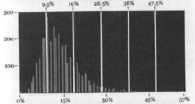
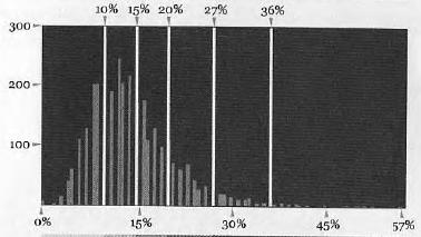
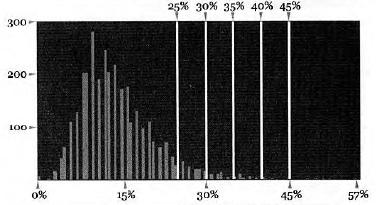
46 Data Classification Quantile Equal Interval Natural Breaks Unique

47 Part 2 - Relational Databases A database of multiple tables that can be joined on unique IDs
48 Joining and Relational Databases Consists of a collection of tables. Each table contains a heading defining the columns, and a body containing the rows of the table. Each row in the table has one or more columns that are unique to that specific row. These Unique IDs exist in multiple tables, matching values represent a relationship between the two tables. Tables can be combined and joined on these Unique IDs. Joining tables is fundamental to GIS.
49

50 Part 3 Descriptive Statistics The first step in any analysis, including spatial analysis, is to look at the distribution of the data. Definition: The arrangement of values that one or more variables take in a dataset. Data is binned Describing the distribution: For interval data, a histogram is a good way to do this For ordinal and nominal data, frequency tables or bar charts are appropriate Mean, Median, and Mode Range and Standard Deviation

51 Descriptive Statistics Using GIS in an Urban Planning setting, you are going to use descriptive summary stats all the time, and there are important things to remember... data is just a part of the puzzle, focusing on trends and averages, not the individual. Ecological Fallacy While working with spatial data, remember to be careful to not simply ascribe an attribute of the group to the individual You will get plenty more of this in your courses

52 Export to Excel Exporting attribute tables to Excel is one way to access, summarize, and manipulate datasets. Do this from Table Options -> Export
53 Part 4 Geoprocessing Geoprocessing is a general term given to a variety of operations on spatial data in which data layers are combined or transformed in different ways to yield new geometric or attribute information. Typical geoprocessing tasks produce new datasets based on set criteria.

54 Geoprocessing So, this begs the question, what is a GIS Operation? GIS Operations are closely related to the database operations we discussed earlier in this lecture. Common Geoprocessing Operations Buffer Clip Intersect Spatial Join Union Merge Calculate Geometry Field Calculator Table Join

55 Used for proximity analysis. Buffer Creates polygon covering area within a specific distance of a feature. Example case use Locating all features near or within a certain distance of a feature.

56 Clip Clips features from one dataset to the extent of another dataset. Example case use Trimming a road dataset down to contain only the roads within a certain city. Clip does not change underlying data. You will need to double check and likely recalculate areas and other attributes after clipping.

57 Intersect Finds common areas between two datasets. Example case use You have a dataset showing income and a dataset showing land uses. You want to find all areas where the two datasets cover the same geographical area. Intersect does not change underlying data but does apply attributes from the intersecting dataset to the input dataset.

58 Dissolve Creates new dataset with new polygons based on common attributes in original dataset. Example case use You have a parcel dataset, you want to create a new dataset of land use based on an attribute associated with the parcels. You run dissolve and get new polygons based on the parcels. IMPORTANT Dissolve runs to the least common denominator, and gets rid of all attributes not common to original polygons.

59 Union Uses to create a union of two datasets. Example case use You have a data showing landcover types from two sources, you want the two datasets in one all encompassing dataset.
60 Spatial Join

61 Merge Used to merge two adjacent datasets into one. Example case use You have two area datasets, adjacent to one another, you want to create a completely new dataset with both of them.

62 Append Used to append one dataset on to another. Schemas should match. Example case use You have two line files, adjacent to one another, you want to add one of the line files to the other.
63 Part 5 Data Extraction Methods Data extraction, or spatial extraction, makes it possible to look at rich disaggregated datasets, such as census data, and extract data and information. Methods of extraction, for example, involve taking census unit level data, which has been aggregated by tract, block, or other, and combining it or modifying it systematically to derive new information and data. (Schlossberg, 2003)


64 Extraction Methods Methods used to extract data when you have multiple varying sources and geographies These are the most common, many exist Intersecting Completely Within Centroids Within Proportional Split

65 Proportional Split Splits polygons to fit shapes or within buffers. Example: Study area splits census block groups, but you still need estimated numbers.
66 Data Extraction Methods Pros and Cons Intersecting Pro Exhaustive / Con Too inclusive Completely within Pro Good targeting / Con Too exclusive Centroids within Pro Good compromise / Con imprecise, adds error Proportional Split Pro forces polygons to mirror study area / Con assumes uniform distribution
67 GIS Open Lab Immediately following this session in Room until 7pm. Set up your environment, test your skills, play with data.
Geographic Systems and Analysis
 Geographic Systems and Analysis New York University Robert F. Wagner Graduate School of Public Service Instructor Stephanie Rosoff Contact: stephanie.rosoff@nyu.edu Office hours: Mondays by appointment
Task 1: Open ArcMap and activate the Spatial Analyst extension.
 Exercise 10 Spatial Analyst The following steps describe the general process that you will follow to complete the exercise. Specific steps will be provided later in the step-by-step instructions component
Introduction to Coastal GIS
 Introduction to Coastal GIS Event was held on Tues, 1/8/13 - Thurs, 1/10/13 Time: 9:00 am to 5:00 pm Location: Roger Williams University, Bristol, RI Audience: The intended audiences for this course are
Spatial Data Analysis with ArcGIS Desktop: From Basic to Advance
 Spatial Data Analysis with ArcGIS Desktop: From Basic to Advance 1. Course overview Modern environmental, energy as well as resource modeling and planning require huge amount of geographically located
SCHOOL OF ENGINEERING AND TECHNOLOGY COMPUTER LAB
 PHASE 1_6 TH SESSION ARCGIS TRAINING AT KU GIS LABS: INTRODUCTION TO GIS: EXPLORING ARCCATALOG AND ARCGIS TOOLS 6 TH SESSION REPORT: 3 RD -5 TH SEPTEMBER 2014 SCHOOL OF ENGINEERING AND TECHNOLOGY COMPUTER
GIS FOR PLANNING. Course Overview. Schedule. Instructor. Prerequisites. Urban Planning 792 Thursday s 5:30-8:10pm SARUP 158
 GIS FOR PLANNING Urban Planning 792 Thursday s 5:30-8:10pm SARUP 158 Schedule Class/Lab - SARUP 158 Thursdays 5:30pm - 8:10pm Office Hours - By Appointment Project Ideas - Week 4 Final - 5/10/2018 Instructor
Introduction to Coastal GIS
 Held on Tues, 1/8/13 through Thurs, 1/10/13 Location: Roger Williams University, Bristol, RI Audience: The intended audiences for this course are federal and state personnel, municipal staff and officials,
Course overview. Grading and Evaluation. Final project. Where and When? Welcome to REM402 Applied Spatial Analysis in Natural Resources.
 Welcome to REM402 Applied Spatial Analysis in Natural Resources Eva Strand, University of Idaho Map of the Pacific Northwest from http://www.or.blm.gov/gis/ Where and When? Lectures Monday & Wednesday
ARCGIS TRAINING AT KU GIS LABS: INTRODUCTION TO GIS: EXPLORING ARCCATALOG AND ARCGIS TOOLS
 PHASE 1_3 rd SESSION ARCGIS TRAINING AT KU GIS LABS: INTRODUCTION TO GIS: EXPLORING ARCCATALOG AND ARCGIS TOOLS 3 rd SESSION REPORT: 25 TH -27 TH JUNE 2014 SCHOOL OF ENVIRONMENTAL STUDIES COMPUTER LAB
In this exercise we will learn how to use the analysis tools in ArcGIS with vector and raster data to further examine potential building sites.
 GIS Level 2 In the Introduction to GIS workshop we filtered data and visually examined it to determine where to potentially build a new mixed use facility. In order to get a low interest loan, the building
Geospatial Intelligence
 Geospatial Intelligence Geospatial analysis has existed as long as humans have made and studied maps but its importance to the intelligence community has skyrocketed in the past several years, with Unmanned
GIS CONCEPTS ARCGIS METHODS AND. 3 rd Edition, July David M. Theobald, Ph.D. Warner College of Natural Resources Colorado State University
 GIS CONCEPTS AND ARCGIS METHODS 3 rd Edition, July 2007 David M. Theobald, Ph.D. Warner College of Natural Resources Colorado State University Copyright Copyright 2007 by David M. Theobald. All rights
CE 365K Exercise 1: GIS Basemap for Design Project Spring 2014 Hydraulic Engineering Design
 CE 365K Exercise 1: GIS Basemap for Design Project Spring 2014 Hydraulic Engineering Design The purpose of this exercise is for you to construct a basemap in ArcGIS for your design project. You may execute
PHASE 1_7 TH SESSION ARCGIS TRAINING AT KU GIS LABS: INTRODUCTION TO GIS: EXPLORING ARCCATALOG AND ARCGIS TOOLS
 PHASE 1_7 TH SESSION ARCGIS TRAINING AT KU GIS LABS: INTRODUCTION TO GIS: EXPLORING ARCCATALOG AND ARCGIS TOOLS 7 TH SESSION REPORT: 10 TH - 12 TH SEPTEMBER 2014 SCHOOL OF ENGINEERING AND TECHNOLOGY COMPUTER
GIS Level 2. MIT GIS Services
 GIS Level 2 MIT GIS Services http://libraries.mit.edu/gis Email: gishelp@mit.edu TOOLS IN THIS WORKSHOP - Definition Queries - Create a new field in the attribute table - Field Calculator - Add XY Data
ARCGIS TRAINING AT KU GIS LABS: INTRODUCTION TO GIS: EXPLORING ARCCATALOG AND ARCGIS TOOLS
 PHASE 1_4 th SESSION ARCGIS TRAINING AT KU GIS LABS: INTRODUCTION TO GIS: EXPLORING ARCCATALOG AND ARCGIS TOOLS 4 th SESSION REPORT: 30 TH JUNE - 2 ND JULY SCHOOL OF ENVIRONMENTAL STUDIES COMPUTER LAB
GIS CONCEPTS ARCGIS METHODS AND. 2 nd Edition, July David M. Theobald, Ph.D. Natural Resource Ecology Laboratory Colorado State University
 GIS CONCEPTS AND ARCGIS METHODS 2 nd Edition, July 2005 David M. Theobald, Ph.D. Natural Resource Ecology Laboratory Colorado State University Copyright Copyright 2005 by David M. Theobald. All rights
Spatial Analysis using Vector GIS THE GOAL: PREPARATION:
 PLAN 512 GIS FOR PLANNERS Department of Urban and Environmental Planning University of Virginia Fall 2006 Prof. David L. Phillips Spatial Analysis using Vector GIS THE GOAL: This tutorial explores some
GED 554 IT & GIS. Lecture 6 Exercise 5. May 10, 2013
 GED 554 IT & GIS Lecture 6 Exercise 5 May 10, 2013 Free GIS data sources ******************* Mapping numerical data & Symbolization ******************* Exercise: Making maps for presentation GIS DATA SOFTWARE
Learning ArcGIS: Introduction to ArcCatalog 10.1
 Learning ArcGIS: Introduction to ArcCatalog 10.1 Estimated Time: 1 Hour Information systems help us to manage what we know by making it easier to organize, access, manipulate, and apply knowledge to the
Massachusetts Institute of Technology Department of Urban Studies and Planning
 Massachusetts Institute of Technology Department of Urban Studies and Planning 11.204: Planning, Communications & Digital Media Fall 2002 Lecture 6: Tools for Transforming Data to Action Lorlene Hoyt October
Acknowledgments xiii Preface xv. GIS Tutorial 1 Introducing GIS and health applications 1. What is GIS? 2
 Acknowledgments xiii Preface xv GIS Tutorial 1 Introducing GIS and health applications 1 What is GIS? 2 Spatial data 2 Digital map infrastructure 4 Unique capabilities of GIS 5 Installing ArcView and the
SRJC Applied Technology 54A Introduction to GIS
 SRJC Applied Technology 54A Introduction to GIS Overview Lecture of Geographic Information Systems Fall 2004 Santa Rosa Junior College Presented By: Tim Pudoff, GIS Coordinator, County of Sonoma, Information
DP Project Development Pvt. Ltd.
 Dear Sir/Madam, Greetings!!! Thanks for contacting DP Project Development for your training requirement. DP Project Development is leading professional training provider in GIS technologies and GIS application
COURSE SCHEDULE, GRADING, and READINGS
 COURSE SCHEDULE, GRADING, and READINGS Note: All academic classes will be held in the GIS lab at Royal Thimphu College. These dates are listed here. Other days will involve travel or days off, and the
GIS and Forest Engineering Applications FE 257 Lecture and laboratory, 3 credits
 GIS and Forest Engineering Applications FE 257 Lecture and laboratory, 3 credits Instructor: Michael Wing Associate Professor Forest Engineering, Resources, and Management Oregon State University Crop
The Geodatabase Working with Spatial Analyst. Calculating Elevation and Slope Values for Forested Roads, Streams, and Stands.
 GIS LAB 7 The Geodatabase Working with Spatial Analyst. Calculating Elevation and Slope Values for Forested Roads, Streams, and Stands. This lab will ask you to work with the Spatial Analyst extension.
Write a report (6-7 pages, double space) on some examples of Internet Applications. You can choose only ONE of the following application areas:
 on some examples of Internet Applications. You can choose only ONE of the following application areas:") UPR 6905 Internet GIS Homework 1 Yong Hong Guo September 9, 2008 Write a report (6-7 pages, double space) on some examples of Internet Applications. You can choose only ONE of the following application
UPR 6905 Internet GIS Homework 1 Yong Hong Guo September 9, 2008 Write a report (6-7 pages, double space) on some examples of Internet Applications. You can choose only ONE of the following application
GIS Boot Camp for Education June th, 2011 Day 1. Instructor: Sabah Jabbouri Phone: (253) x 4854 Office: TC 136
 x 4854 Office: TC 136") GIS Boot Camp for Education June 27-30 th, 2011 Day 1 Instructor: Sabah Jabbouri Phone: (253) 833-9111 x 4854 Office: TC 136 Email: sjabbouri@greenriver.edu http://www.instruction.greenriver.edu/gis/ Summer
GIS Boot Camp for Education June 27-30 th, 2011 Day 1 Instructor: Sabah Jabbouri Phone: (253) 833-9111 x 4854 Office: TC 136 Email: sjabbouri@greenriver.edu http://www.instruction.greenriver.edu/gis/ Summer
Vector Analysis: Farm Land Suitability Analysis in Groton, MA
 Vector Analysis: Farm Land Suitability Analysis in Groton, MA Written by Adrienne Goldsberry, revised by Carolyn Talmadge 10/9/2018 Introduction In this assignment, you will help to identify potentially
NR402 GIS Applications in Natural Resources
 NR402 GIS Applications in Natural Resources Lesson 1 Introduction to GIS Eva Strand, University of Idaho Map of the Pacific Northwest from http://www.or.blm.gov/gis/ Welcome to NR402 GIS Applications in
Fundamentals of ArcGIS Desktop Pathway
 Fundamentals of ArcGIS Desktop Pathway Table of Contents ArcGIS Desktop I: Getting Started with GIS 3 ArcGIS Desktop II: Tools and Functionality 5 Understanding Geographic Data 8 Understanding Map Projections
URP 4273 Section 3058 Survey Of Planning Information Systems (3 Credits) Spring 2017
 Spring 2017") URP 4273 Section 3058 Survey Of Planning Information Systems (3 Credits) Spring 2017 Instructor: Office Periods: Stanley Latimer 466 ARCH Phone: 352 294-1493 e-mail: latimer@geoplan.ufl.edu Monday Thursday,
URP 4273 Section 3058 Survey Of Planning Information Systems (3 Credits) Spring 2017 Instructor: Office Periods: Stanley Latimer 466 ARCH Phone: 352 294-1493 e-mail: latimer@geoplan.ufl.edu Monday Thursday,
94-802Z: Geographic Information Systems Summer 2018
 94-802Z: Geographic Information Systems Summer 2018 Instructor: Professor Kristen Kurland Teaching Assistant(s): (Office hours to be posted on Canvas) TBA Class Web Site: http:/www.cmu.edu/canvas
Exercise on Using Census Data UCSB, July 2006
 Exercise on Using Census Data UCSB, July 2006 Purpose The purpose of this lab is to become familiar with Census Bureau data. Second, we will learn how to join tables which allows you to add data to the
Overlay Analysis II: Using Zonal and Extract Tools to Transfer Raster Values in ArcMap
 Overlay Analysis II: Using Zonal and Extract Tools to Transfer Raster Values in ArcMap Created by Patrick Florance and Jonathan Gale, Edited by Catherine Ressijac on March 26, 2018 If you have raster data
Lecture 1 Introduction to GIS. Dr. Zhang Spring, 2017
 Lecture 1 Introduction to GIS Dr. Zhang Spring, 2017 Topics of the course Using and making maps Navigating GIS Map design Working with spatial data Geoprocessing Spatial data infrastructure Digitizing
Linear Referencing in Boulder County, CO. Getting Started
 Linear Referencing in Boulder County, CO Getting Started 1 Authors Janie Pierre GIS Technician, Boulder County Road centerline and storm sewer geodatabases & maps John Mosher GIS Specialist, Boulder County
Visualizing Census Data in GIS. Andrew Rowan, Ph.D. Director, NJ Office of GIS
 Visualizing Census Data in GIS Andrew Rowan, Ph.D. Director, NJ Office of GIS Outline VERY accelerated cartography primer Software choices Demos/how-to ArcGIS Desktop (formerly ArcView) ArcGIS Online Notes
Using CAD data in ArcGIS
 Using CAD data in ArcGIS Phil Sanchez and Jeff Reinhart Esri UC 2014 Technical Workshop Agenda Overview of ArcGIS CAD Support Using CAD Datasets in ArcMap Georeferencing CAD data for ArcGIS Loading CAD
DRAFT SYLLABUS. Please use Blackboard to send messages.
 SYLLABUS Course Title: Geographic Information Systems and Spatial Analysis for Public Policy Academic Department/Course Number: PUBP 754 Semester/Year: Fall 2017 Building/Room: FH 307 Days/Time: W 4:30
GEOG 508 GEOGRAPHIC INFORMATION SYSTEMS I KANSAS STATE UNIVERSITY DEPARTMENT OF GEOGRAPHY FALL SEMESTER, 2002
 GEOG 508 GEOGRAPHIC INFORMATION SYSTEMS I KANSAS STATE UNIVERSITY DEPARTMENT OF GEOGRAPHY FALL SEMESTER, 2002 Course Reference #: 13210 Meeting Time: TU 2:05pm - 3:20 pm Meeting Place: Ackert 221 Remote
Geodatabase An Introduction
 Federal GIS Conference 2014 February 10 11, 2014 Washington DC Geodatabase An Introduction Ralph Denkenberger esri Session Path The Geodatabase - What is it? - Why use it? - What types are there? Inside
URP 4273 Section 8233 Introduction to Planning Information Systems (3 Credits) Fall 2017
 Fall 2017") URP 4273 Section 8233 Introduction to Planning Information Systems (3 Credits) Fall 2017 Instructor: Office Periods: Stanley Latimer 466 ARCH Phone: 352 294-1493 e-mail: latimer@geoplan.ufl.edu Monday
URP 4273 Section 8233 Introduction to Planning Information Systems (3 Credits) Fall 2017 Instructor: Office Periods: Stanley Latimer 466 ARCH Phone: 352 294-1493 e-mail: latimer@geoplan.ufl.edu Monday
CHAPTER 9 DATA DISPLAY AND CARTOGRAPHY
 CHAPTER 9 DATA DISPLAY AND CARTOGRAPHY 9.1 Cartographic Representation 9.1.1 Spatial Features and Map Symbols 9.1.2 Use of Color 9.1.3 Data Classification 9.1.4 Generalization Box 9.1 Representations 9.2
Popular Mechanics, 1954
 Introduction to GIS Popular Mechanics, 1954 1986 $2,599 1 MB of RAM 2017, $750, 128 GB memory, 2 GB of RAM Computing power has increased exponentially over the past 30 years, Allowing the existence of
These modules are covered with a brief information and practical in ArcGIS Software and open source software also like QGIS, ILWIS.
 Online GIS Training and training modules covered are: 1. ArcGIS, Analysis, Fundamentals and Implementation 2. ArcGIS Web Data Sharing 3. ArcGIS for Desktop 4. ArcGIS for Server These modules are covered
Spatial Analysis and Modeling (GIST 4302/5302) Guofeng Cao Department of Geosciences Texas Tech University
 Guofeng Cao Department of Geosciences Texas Tech University") Spatial Analysis and Modeling (GIST 4302/5302) Guofeng Cao Department of Geosciences Texas Tech University TTU Graduate Certificate Geographic Information Science and Technology (GIST) 3 Core Courses and
Spatial Analysis and Modeling (GIST 4302/5302) Guofeng Cao Department of Geosciences Texas Tech University TTU Graduate Certificate Geographic Information Science and Technology (GIST) 3 Core Courses and
Intro to GIS In Review
 Intro to GIS In Review GIS Analysis Winter 2016 GIS A quarter in review Geographic data types Acquiring GIS data Projections / Coordinate systems Working with attribute tables Data classification Map design
Rural Louisiana. A quarterly publication of the Louisiana Tech Rural Development Center
 Rural Louisiana A quarterly publication of the Louisiana Tech Rural Development Center Volume 4, No. 1, Fall 2009 Editor: Aaron K. Lusby Director, Asst. Professor Newsletter design: Stephanie Tidwell Student
Quiz 1. Quiz Instruc ons. Question 1. Question 2. 2 pts. 3 pts. This is a preview of the published version of the quiz. Started: Jul 3 at 4:29pm
 Quiz 1 This is a preview of the published version of the quiz Started: Jul 3 at 4:29pm Quiz Instruc ons Quiz 1 Question 1 Which of the following is not a basic element of map design that should be considered
ArcGIS Online Analytics. Mike Flanagan
 ArcGIS Online Analytics Mike Flanagan MFlanagan@esri.com Agenda Introduction to ArcGIS Online Spatial Analysis ArcGIS Online Spatial Analysis Workflow Demos and Examples Wrap-up Q&A ArcGIS A complete web
GIS ADMINISTRATOR / WEB DEVELOPER EVANSVILLE-VANDERBURGH COUNTY AREA PLAN COMMISSION
 GIS ADMINISTRATOR / WEB DEVELOPER EVANSVILLE-VANDERBURGH COUNTY AREA PLAN COMMISSION SALARY RANGE INITIATION $43,277 SIX MONTHS $45,367 POSITION GRADE PAT VI The Evansville-Vanderburgh County Area Plan
Using ArcGIS Server to Bring Geospatial Analysis
 Using ArcGIS Server to Bring Geospatial Analysis and Mapping to non-gis Analysts ESRI Health User Conference September 22, 2009 Jim Laramie, Altarum Institute Sam Wang, Altarum Institute Agenda Agenda
Lecture 2. A Review: Geographic Information Systems & ArcGIS Basics
 Lecture 2 A Review: Geographic Information Systems & ArcGIS Basics GIS Overview Types of Maps Symbolization & Classification Map Elements GIS Data Models Coordinate Systems and Projections Scale Geodatabases
HISTORY 1XX/ DH 1XX. Introduction to Geospatial Humanities. Instructor: Zephyr Frank, Associate Professor, History Department Office: Building
 HISTORY 1XX/ DH 1XX Introduction to Geospatial Humanities Instructor: Zephyr Frank, Associate Professor, History Department Office: Building 200-332 Course Description This course introduces undergraduate
(THIS IS AN OPTIONAL BUT WORTHWHILE EXERCISE)
") PART 2: Analysis in ArcGIS (THIS IS AN OPTIONAL BUT WORTHWHILE EXERCISE) Step 1: Start ArcCatalog and open a geodatabase If you have a shortcut icon for ArcCatalog on your desktop, double-click it to start
PART 2: Analysis in ArcGIS (THIS IS AN OPTIONAL BUT WORTHWHILE EXERCISE) Step 1: Start ArcCatalog and open a geodatabase If you have a shortcut icon for ArcCatalog on your desktop, double-click it to start
ARCGIS PRO COURSE, BEGINNER LEVEL ONLINE TRAINING GIS. Course. Training. .com
 ARC PRO COURSE, BEGINNER LEVEL ONLINE TRAINING Course.com TYC TRAINING OVERVIEW This course will provide a basic introduction in Arc PRO, the new Arc Desktop release. The training material will be focused
GIS and Forest Engineering Applications FE 357 Lecture: 2 hours Lab: 2 hours 3 credits
 GIS and Forest Engineering Applications FE 357 Lecture: 2 hours Lab: 2 hours 3 credits Instructor: Michael Wing Assistant Professor Forest Engineering Department Oregon State University Peavy Hall 275
Week 01 Lecture Notes Antelope Valley College Geography 205
 I. Introduction to GIS a. Tonight we ll discuss i. What GIS is and isn t ii. Software iii. Data iv. Documents v. File Structure II. GIS a. What it is i. Geographic Information Systems ii. A way of storing,
Overview key concepts and terms (based on the textbook Chang 2006 and the practical manual)
") Introduction Geo-information Science (GRS-10306) Overview key concepts and terms (based on the textbook 2006 and the practical manual) Introduction Chapter 1 Geographic information system (GIS) Geographically
Introduction Geo-information Science (GRS-10306) Overview key concepts and terms (based on the textbook 2006 and the practical manual) Introduction Chapter 1 Geographic information system (GIS) Geographically
ArcGIS Pro: Essential Workflows STUDENT EDITION
 ArcGIS Pro: Essential Workflows STUDENT EDITION Copyright 2018 Esri All rights reserved. Course version 6.0. Version release date August 2018. Printed in the United States of America. The information contained
Week 8 Cookbook: Review and Reflection
 : Review and Reflection Week 8 Overview 8.1) Review and Reflection 8.2) Making Intelligent Maps: The map sheet as a blank canvas 8.3) Making Intelligent Maps: Base layers and analysis layers 8.4) ArcGIS
Introduction to ArcGIS Server - Creating and Using GIS Services. Mark Ho Instructor Washington, DC
 Introduction to ArcGIS Server - Creating and Using GIS Services Mark Ho Instructor Washington, DC Technical Workshop Road Map Product overview Building server applications GIS services Developer Help resources
90-834: Health Geographic Information Systems Spring Semester 2017
 90-834: Health Geographic Information Systems Spring Semester 2017 Prerequisite: 90-728 (Introduction to Database Management Systems), or 91-802 (Information Systems for Managers), or equivalent course
GIS Lecture 4: Data. GIS Tutorial, Third Edition GIS 1
 GIS Lecture 4: Data GIS 1 Outline Data Types, Tables, and Formats Geodatabase Tabular Joins Spatial Joins Field Calculator ArcCatalog Functions GIS 2 Data Types, Tables, Formats GIS 3 Directly Loadable
Introduction to the 176A labs and ArcGIS
 Introduction to the 176A labs and ArcGIS Acknowledgement: Slides by David Maidment, U Texas-Austin and Francisco Olivera (TAMU) Purpose of the labs Hands-on experience with one software pakage Introduction
Steve Pietersen Office Telephone No
 Steve Pietersen Steve.Pieterson@durban.gov.za Office Telephone No. 031 311 8655 Overview Why geography matters The power of GIS EWS GIS water stats EWS GIS sanitation stats How to build a GIS system EWS
Map your way to deeper insights
 Map your way to deeper insights Target, forecast and plan by geographic region Highlights Apply your data to pre-installed map templates and customize to meet your needs. Select from included map files
ARCGIS COURSE, BEGINNER LEVEL ONLINE TRAINING
 ARC COURSE, BEGINNER LEVEL ONLINE TRAINING Course.com TYC TRAINING OVERVIEW This course will qualify students to use Arc Desktop 10 and in particular, ArcMap, ArcCatalog and ArcTool Box, focusing on the
Data Structures & Database Queries in GIS
 Data Structures & Database Queries in GIS Objective In this lab we will show you how to use ArcGIS for analysis of digital elevation models (DEM s), in relationship to Rocky Mountain bighorn sheep (Ovis
Urban Planning Internet Geographic Information Systems Fall 2010
 Urban Planning - 794 Internet Geographic Information Systems Fall 2010 Instructor: Professor Huxhold (hux@uwm.edu) Lecturer: Melissa Mann (mmann@uwm.edu) Manager: Kurt Meingast (kurtm@uwm.edu) Schedule:
CAD: Introduction to using CAD Data in ArcGIS. Kyle Williams & Jeff Reinhart
 CAD: Introduction to using CAD Data in ArcGIS Kyle Williams & Jeff Reinhart What we will accomplish today Overview of ArcGIS CAD Support Georeferencing CAD data for ArcGIS How Mapping Specification for
No. of Days. Building 3D cities Using Esri City Engine ,859. Creating & Analyzing Surfaces Using ArcGIS Spatial Analyst 1 7 3,139
 Q3 What s New? Creating and Editing Data with ArcGIS Pro Editing and Maintaining Parcels Using ArcGIS Spatial Analysis Using ArcGIS Pro User Workflows for ArcGIS Online Organizations Q3-2018 ArcGIS Desktop
Exercise 2: Working with Vector Data in ArcGIS 9.3
 Exercise 2: Working with Vector Data in ArcGIS 9.3 There are several tools in ArcGIS 9.3 used for GIS operations on vector data. In this exercise we will use: Analysis Tools in ArcToolbox Overlay Analysis
Working with ArcGIS: Classification
 Working with ArcGIS: Classification 2 Abbreviations D-click R-click TOC Double Click Right Click Table of Content Introduction The benefit from the use of geographic information system (GIS) software is
EEOS 465 / 627 Environmental Modeling with Raster GIS. David Tenenbaum EEOS 465 / 627 UMass Boston
 EEOS 465 / 627 Environmental Modeling with Raster GIS EEOS 465 / 627 Environmental Modeling with Raster GIS Course Description: This course consists of three parts: In the first four weeks, we will focus
WlLPEN L. GORR KRISTEN S. KURLAND. Universitats- und Landesbibliothek. Bibliothek Architektur und Stadtebau ESRI
 hj WlLPEN L. GORR KRISTEN S. KURLAND Universitats- und Landesbibliothek Darmstadt Bibliothek Architektur und Stadtebau ESRI Contents Acknowledgments Preface xvii XV GIS Tutorial 1 Introduction Launch ArcMap
Migrating Defense Workflows from ArcMap to ArcGIS Pro. Renee Bernstein and Jared Sellers
 Migrating Defense Workflows from ArcMap to ArcGIS Pro Renee Bernstein and Jared Sellers ArcGIS Desktop Desktop Web Device ArcMap ArcCatalog ArcScene ArcGlobe ArcGIS Pro portal Server Online Content and
GIS PORTFOLIO MOHAMED MAGDY MOHAMED HUSSAIN GIS ENGINEER. UWF GIS ONLINE CERTIFICATE GIS Internship (GIS4944)
") 2012 GIS PORTFOLIO MOHAMED MAGDY MOHAMED HUSSAIN GIS ENGINEER UWF GIS ONLINE CERTIFICATE GIS Internship (GIS4944) Portfolio Table of Contents Subject... Page Personal statement/mission/philosophy... 1
2012 GIS PORTFOLIO MOHAMED MAGDY MOHAMED HUSSAIN GIS ENGINEER UWF GIS ONLINE CERTIFICATE GIS Internship (GIS4944) Portfolio Table of Contents Subject... Page Personal statement/mission/philosophy... 1
Charlene Nielsen, MSc.
 GIS Project Issues Charlene Nielsen, MSc charlene.nielsen@ualberta.ca 492-93979397 B414 BioSci Building www.biology.ualberta.ca/facilities/gis Introduction to GIS in Ecology What a GIS is not What is a
Lecture 9: Geocoding & Network Analysis
 Massachusetts Institute of Technology - Department of Urban Studies and Planning 11.520: A Workshop on Geographic Information Systems 11.188: Urban Planning and Social Science Laboratory Lecture 9: Geocoding
GIS Quick Facts. CIVL 1101 GIS Quick Facts 1/5.
 CIVL 1101 1/5 What is GIS? Geographic Information Systems (GIS) provide a platform for displaying and analyzing spatial data. GIS systems allow you to view multiple layers of data simultaneously. GIS is
Workshop and Session Descriptions
 MONDAY, SEPTEMBER 14 Workshops (Full-day) Workshop and Session Descriptions 1. Bridging the surveyed gap: How land surveying data works with GIS GIS professionals use a myriad of data to construct their
Tutorial 8 Raster Data Analysis
 Objectives Tutorial 8 Raster Data Analysis This tutorial is designed to introduce you to a basic set of raster-based analyses including: 1. Displaying Digital Elevation Model (DEM) 2. Slope calculations
Lecture 5. Symbolization and Classification MAP DESIGN: PART I. A picture is worth a thousand words
 Lecture 5 MAP DESIGN: PART I Symbolization and Classification A picture is worth a thousand words Outline Symbolization Types of Maps Classifying Features Visualization Considerations Symbolization Symbolization
Theory, Concepts and Terminology
 GIS Workshop: Theory, Concepts and Terminology 1 Theory, Concepts and Terminology Suggestion: Have Maptitude with a map open on computer so that we can refer to it for specific menu and interface items.
GEOGRAPHIC INFORMATION SYSTEMS
 GEOGRAPHIC INFORMATION SYSTEMS 4-H Round-Up Community Transitions Workshop Daniel Hanselka June 14, 2011 Goals of the Workshop Answer the question: What is GIS? Uses of GIS. Some of the Common Terminology
Classification Exercise UCSB July 2006
 Classification Exercise UCSB July 2006 Purpose This exercise will examine how spatial data is catergorized and the advantages and disadvantages of different classification methods. Terms to know Population,
GIS Software. Evolution of GIS Software
 GIS Software The geoprocessing engines of GIS Major functions Collect, store, mange, query, analyze and present Key terms Program collections of instructions to manipulate data Package integrated collection
INTRODUCTION TO GIS. Dr. Ori Gudes
 INTRODUCTION TO GIS Dr. Ori Gudes Outline of the Presentation What is GIS? What s the rational for using GIS, and how GIS can be used to solve problems? Explore a GIS map and get information about map
Lecture 3 GIS outputs. Dr. Zhang Spring, 2017
 Lecture 3 GIS outputs Dr. Zhang Spring, 2017 Model of the course Using and making maps Navigating GIS maps Map design Working with spatial data Geoprocessing Spatial data infrastructure Digitizing File
WHAT MAKES A GOOD GIS LAB EXERCISE? Robert N. Martin
 WHAT MAKES A GOOD GIS LAB EXERCISE? Robert N. Martin ABSTRACT Having taught GIS for over fifteen years in a lecture/laboratory format, I have developed a series of laboratory exercise that provide a good
Display data in a map-like format so that geographic patterns and interrelationships are visible
 Vilmaliz Rodríguez Guzmán M.S. Student, Department of Geology University of Puerto Rico at Mayagüez Remote Sensing and Geographic Information Systems (GIS) Reference: James B. Campbell. Introduction to
Are You Maximizing The Value Of All Your Data?
 Are You Maximizing The Value Of All Your Data? Using The SAS Bridge for ESRI With ArcGIS Business Analyst In A Retail Market Analysis SAS and ESRI: Bringing GIS Mapping and SAS Data Together Presented
Geodatabase Management Pathway
 Geodatabase Management Pathway Table of Contents ArcGIS Desktop II: Tools and Functionality 3 ArcGIS Desktop III: GIS Workflows and Analysis 6 Building Geodatabases 8 Data Management in the Multiuser Geodatabase
Esri UC2013. Technical Workshop.
 Esri International User Conference San Diego, California Technical Workshops July 9, 2013 CAD: Introduction to using CAD Data in ArcGIS Jeff Reinhart & Phil Sanchez Agenda Overview of ArcGIS CAD Support
Creating Basemaps to Manage Buildings and Facilities
 Esri International User Conference San Diego, California Technical Workshops July 26, 2012 Creating Basemaps to Manage Buildings and Facilities Mark Stewart and Tamara Yoder Topics for this Session Overview
ARCGIS PRO COURSE, APPLIED TO ENVIROMENTAL MANAGEMENT GIS. Course. Training. .com
 ARC PRO COURSE, APPLIED TO ENVIROMENTAL MANAGEMENT TYC Training Course.com TRAINING OVERVIEW This Arc Pro online course will provide a great deal of information about the link between earth s ecosystems
Arcmap Manual Esri 10 READ ONLINE
 Arcmap Manual Esri 10 READ ONLINE Esri Store: Browsing ArcPad 10.2.2 - ArcPad is mobile field mapping and data collection software designed for GIS professionals. It includes advanced GIS and GPS capabilities