Advanced World Geography Chapter 01 Exploring Geography
|
|
|
- Godwin Cannon
- 5 years ago
- Views:
Transcription


1 Advanced World Geography Chapter 01 Exploring Geography Lesson 1 Study of Geography In this lesson you will learn how to: tell what geography is and what geographic tools are used. tell what the various geographic themes are and what they entail. describe places that may have absolute and relative locations, as well as human and physical characteristics. describe the interaction that occurs between people and their environments, and how these interactions can have positive and negative consequences. Exploring Geography What comes to mind when you think of your world? Some may see their world as their home, school, state, and other places that connect them. Others may see it as places they have been, read about, or seen on television. Some, however, see it as the entire planet. No matter how you view the world, the study of geography will help you to see your world from various angles. Through the study of geography, you will learn about the earth, those who inhabit it, and the different relationships between them. Study of Geography. People have always been and still are curious about the world around them. Because of this, we know a great deal of information about our surroundings. In a small way, people have always had some desire to be geographers and explore the things around them. What then is geography? Geography is the study of where people, places, and things are located and how they interact and relate to one another. Ultimately, geography allows man to discover and organize information about the many facets of the world. Geography looks at the earth s surface and the different courses of action that shape it. Also, it observes the people who inhabit the earth, and examines their diverse cultures and economies. Geography explores the intricate relationships that develop between people and their environments.

2 Geographic Tools Technology. Scientific approaches are used in geography to examine and understand where things are located. A sonar is one of the tools that has been used for decades. The word sonar stands for SOund, NAvigation, and Ranging. Sonar analyze sound to verify distance and direction. It was developed in 1906 to find icebergs, soon becoming an important tool used by the military during World War I to identify and avoid submarines. In geography, however, sonar is used for looking at the ocean floor. Remote-sensing technology like satellites are also used by geographers. The United States has relied on the Landsat Program for information since By 1999, Landsat 7 was launched. It recorded images of the surface of the earth and downloaded them to a computer. With that information, scientists are able to compare old and new images and identify changes in the land, vegetation, and urban growth. New ventures for studying the earth are always being presented by technological advances. In recent years, geographers have come to depend on the global positioning system (GPS). The GPS system depends on a group of 24 satellites that are always orbiting the earth. The satellites give extremely accurate time measurements by using atomic clocks. On earth, GPS units then provide information about location by analyzing these time signals. The geographic information systems (GIS) are another innovation that is growing in importance. The GIS uses computer technology to gather, influence, examine, and present data about the surface of the earth to solve geographic problems. This system may combine information collected from satellite photos, census results, or tax assessors. Then, the information is layered by computers to show the relationships among the information gathered. The GIS system can be used to study a variety of things ranging from public health to retail market size. An example of GIS data layers. Source: csc.noaa.gov

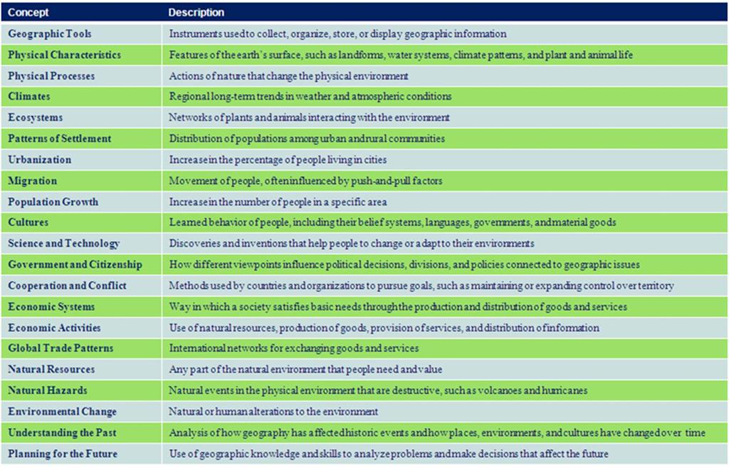
3 Many people only think of geography when finding a place to live or somewhere to travel to. One may be surprised to find that well developed geographic skills can enable a person to be more successful in their career. Maybe someone will protected a wildlife habitat or develop a new source of energy. Geography is an important element to everyone s life when they better understand what it is. Geographic Concepts. While people who are geographically informed generally use tools like maps, charts, and graphs, they can also use a tool known as geographic concepts. People use ideas as tools to help organize the way one thinks about geography. Some of the geographic concepts are: physical characteristics, patterns of settlement, science and technology, and economic activities (see chart on next slide). Each concept helps us identify and comprehend geographic patterns and methods that we can relate to in real life situations around us. For instance, physical processes like volcanoes, earthquakes, and erosion have always and still do shape the world around us. As you study geography, you will use these and other concepts to study how people, environments, and places are connected. You will learn how to use geography to figure out the past and present. You will be more able to make good decisions that will shape your future by identifying and understanding geographic patterns. GPS units are used to for navigating both short and long distances.
4

5 Geographic concepts can be used to organize and interpret information about the earth. By understanding the concepts, one can recognize the geographic patterns and processes that shape ones world. Source: Pearson Education, Inc. Five Themes of Geography Human curiosity fuels the study of geography. There are five questions that are pertinent to the organization of information regarding places (see below). Each one of these questions is directly related to one of the five themes geographers use when organizing what they have studied in the world. These five themes are: location, place, regions, human-environment interaction, and movement. These different themes offer an alternative way of viewing the world and those who inhabit it. These themes, however, are not mutually exclusive. For one to fully understand a place or problem, one would have to know how each theme relates to one another. Questions? What is the location of a place? What is the character of a place? How do people interact with the natural environment of a place? How do people, good, and ideas move between places? How are places similar to and different from other places? Geography has made us neighbors. History has made us friends. Economics has made us partners, and necessity has made us allies. Those whom God has so joined together, let no man put asunder. John Fitzgerald Kennedy Location. The study of a place typically begins with finding the location. When describing the location of a place, the location can either be expressed in absolute or relative terms. The first of these terms is absolute location. The absolute location of a place is its position on the globe. The more common way to locate a places absolute location is by using the imaginary lines drawn on the surface of the earth on some maps. One of these lines is the Equator, an imaginary line that circles the globe halfway between the North and South poles. The Equator divides the earth into hemispheres, or halves. The land and water located between the Equator and the North Pole is in the Northern Hemisphere; while the land and water between the Equator and the South Pole is in the Southern Hemisphere.

6 Another set of imaginary lines runs parallel to the Equator, called lines of latitude, or parallels. These lines measure the distance north and south of the Equator. The Equator is located at 0, while the North and South poles are located at 90. The boundaries of the places on earth that receive the most direct sunlight and the most heat energy from the sun are marked by the Tropic of Cancer at 23½ N and the Tropic of Capricorn at 23½ S. These two areas receive the most sun because the earth is tilted 23½ as it revolves around the sun. Lines of longitude, or meridians, are another set of imaginary lines. These lines run north and south between the two poles. At 0, the Prime Meridian runs through the Royal Observatory in Greenwich, England. The other meridians are calculated in degrees from 0 to 180 east or west of Greenwich. Meridians are not parallel to one another. The distance between meridians is greatest at the Equator, but decrease as you get closer to the poles. While using the grid made by the lines of longitude and latitude, one can find the absolute location of anywhere on earth. For example, New Orleans is located at 90 W longitude and 30 N latitude, while Cairo, Egypt is located at 30 E longitude and 30 N latitude. Arctic Circle Tropic Cancer of Relative location is defined as a point or place in relation to another point or place. For example, Birmingham, Alabama can be described as being southwest of Ashville, North Carolina. While each location only has one absolute location, they have many different relative locations which can change as time goes on. For instance, New York City, New York was once seen as days and days of travel away from San Diego, California. Now, one can board an airplane and be there in no time, making them only hours away. Tropic of Capricorn
7 Latitude and Longitude YouTube


8 Place Each place on this planet has different features that make it stand out from other places. One of the biggest challenges faced in geography is to figure out how places are similar to and different from one another. Physical Characteristics. Every place has physical characteristics that make it stand out from the rest such as land forms, plant life, and climate. Physical characteristics of a place vary depending on their location in the world. Some land might be flat, mountainous, or anywhere in between the two. Plant life, or vegetation, can range anywhere from plush rain forests, to a tundra with little moss coverage. A place s climate goes beyond the weather patterns of an area, to the natural disasters that occur like tornadoes, hurricanes, earth quakes, droughts, and floods. Human Characteristics. A place can also be described by the use of its human characteristics. How many people are living, visiting, and working in a place? What do they believe and what languages do they speak? What does their economy and government look like? Geographers study human activities to better answer these types of questions. A dancer in the traditional attire of a Hawaiian luau. With unique combinations of physical and human characteristics, each place on Earth is matchless. Those who return home after traveling do not tell about a place s longitude and latitude. Instead, they speak about the people, environment, and traditions that made their trip unforgettable. At the same time, they may have spoken the same language, used the same type of money, and watched the same movies at home. The complex mix of distinctive and ordinary features is what a geographer means when they speak about a place.

9 Regions Another geographic theme deals with regions. A region can be defined as a group of places that contain at least one common characteristic. At times, a region is determined by a person s perception. Perception is a point of view that is influenced by one s culture and experiences. The world is divided into many different regions by geographers. Formal regions are defined as areas with a specific characteristic that is seen throughout those areas. For instance, states, countries, and cities are all categorized as political regions. People in these formal regions are subject to the same laws and ruled by the same government. Other characteristics can also be used to define formal regions. New York City is home to Little Italy, a section of the city containing many Italian-American people, stores, and restaurants. The Cotton Belt is a section of the United States where cotton is produced in abundance. Functional regions are comprised of one central place and the surrounding places that are affected by it. Functional regions can be defined using different types of criteria. For instance, the Amazon drainage basin in South America is the region that is drained by the Amazon River. In Los Angeles, California, the metropolitan region is comprised of the city of Los Angeles and the suburbs that surround it. Another type of region is a perceptual region. They are defined by a person s feelings and attitudes about an area. Regions like Dixie, the upper Midwest, and the Middle States do not have exact borders. For instance, if you ask someone in Orlando if Florida is in the deep south and part of Dixie, you would get a mixture of answers, depending on the person s individual perception. Since different criteria can be used to define a region, the same place may be categorized in several regions. For example, Mexico is a part of the continent of North America. Culturally, it is linked to the Spanish-speaking nations of Central and South America. Little Italy in New York City. Source: rutgers.edu


10 Human/Environment Relations The next geographical theme looks at how people use their environment. Questions may arise like: Have they altered the environment? What consequences come with the alterations made? How have the people in the environment responded to the changes made? People have made enormous changes to their environments, whether intentional or accidental. Some of the changes made are destructive, while others are constructive. For example, the Southwestern portion of the United States has taken on big changes. Originally, this hot, dry region of the country had little to no population. With the inventions of the airconditioner, swimming pool, substantial irrigation, and the car, this area has become one of the fastest growing regions in the United States. People from all over flock to the area in hopes of finding a comfortable place for retirement. The natural environment of the area has been heavily altered by the construction of big buildings and roadways. The already inadequate supply of water is being exhausted by the rapid population growth. Changes like this one may cause huge problem down the road. Movement Places do not exist in seclusion. Since places have differing characteristics, it follows that people, goods, and ideas will flow between them. This last geographic theme looks at the impact geography has on movement. There are different types of movement. These include: migration, transportation, and the spread of ideas (e.g. religion, communication). The history of Atlanta, Georgia lays out the importance of movement. It was established in 1837 at the end, or terminus, of a section or railroad. The city was even named Terminus in the beginning. It was a major Confederate supply center during the Civil War because of its rail connections. Atlanta was rebuild after the war and is, to this day, a vital transportation hub in the Southeast. Once a hot, desert land, Phoenix, Arizona has been transformed into a thriving city.


11 Today, Atlanta is still heavily depends on movement. The links of transportation in the city have attracted many companies that rely on distribution and manufacturing. In response to the new companies, jobs have been made and the city has grown. Also, the airport, Atlanta s Hartfield International Airport, is one of the biggest and busiest in the nation. Vocabulary: Absolute location a place s location on a globe. Equator - an imaginary line that circles the globe halfway between the North and South poles. Formal region an area with a specific characteristic that is seen through out that area. Functional region - one central place and the surrounding places that are affected by it. Geography - the study of where people, places, and things are located and how they interact and relate to one another. GIS - Geographic Information Systems use computer technology to gather, influence, examine, and present data about the surface of the earth to solve geographic problems. GPS Global Positioning System rely on satellite images to communicate location and direction. Hemisphere the northern or southern portion of the globe as divided by the equator. Atlanta's city area is a huge transportation hub.


12 Latitude - imaginary lines that measure the distance north and south of the Equator. Longitude imaginary lines that run north and south between the two poles. Perception - a point of view that is influenced by one s culture and experiences. Perceptual Region region defined by a person s feelings and attitudes about that area. Prime Meridian the line of longitude that runs at 0. Relative location - a point or place in relation to another point or place. SONAR stands for Sound Navigation, and Ranging, and is a form of technology that analyzes sound to verify direction and location. After reviewing the material in this lesson, please complete the Advanced World Geography, Chapter 01, Lesson 1 Learning Check and Quiz.
CHAPTER 1: EXPLORING GEOGRAPHY
 CHAPTER 1: EXPLORING GEOGRAPHY Please Do Now: In your PDN section of your binder answer the following with one or two sentences: What is Geography? What is Geography? The study of where people, places,
UNIT 1 THE BASICS OF GEOGRAPHY
 UNIT 1 THE BASICS OF GEOGRAPHY CHAPTER 1 LOOKING AT THE EARTH 1 Section 1.1: The 5 Themes of Geography.Geography comes from a Greek word meaning writing about or describing the earth. Geography is: Geographers
Unit 1 The Basics of Geography. Chapter 1 The Five Themes of Geography Page 5
 Unit 1 The Basics of Geography Chapter 1 The Five Themes of Geography Page 5 Geography comes from the Greek word geographia, which means to describe the earth. Geography is the study of the distribution
Geography involves the study of places: their locations, their characteristics, and how humans use and move around them.
 Physical Geography Looking at the Earth Geography involves the study of places: their locations, their characteristics, and how humans use and move around them. NEXT Physical Geography Looking at the Earth
STUDY GUIDE. Exploring Geography. Chapter 1, Section 1. Terms to Know DRAWING FROM EXPERIENCE ORGANIZING YOUR THOUGHTS
 For use with textbook pages 19 22. Exploring Geography Terms to Know location A specific place on the earth (page 20) absolute location The exact spot at which a place is found on the globe (page 20) hemisphere
Map Skills Unit. Note taking unit
 Map Skills Unit Note taking unit Introduction To learn about the Earth, we are going to learn about two geographic tools you can use.globes and maps. Globe A globe is a round model of the planet Earth
Chapter 2 - Lessons 1 & 2 Studying Geography, Economics
 Chapter 2 - Lessons 1 & 2 Studying Geography, Economics How does geography influence the way people live? Why do people trade? Why do people form governments? Lesson 1 - How Does Geography Influence the
Exploring Geography. Chapter 1
 Exploring Geography Chapter 1 The Study of Geography Geography is the study of where people, places, and things are located and how they relate to each other. Greek meaning writing about or describing
GRADE 6 GEOGRAPHY TERM 1 LATITUDE AND LONGITUDE (degrees)
") 1 GRADE 6 GEOGRAPHY TERM 1 LATITUDE AND LONGITUDE (degrees) Contents Lines of Latitude... 2 Lines of Longitude... 3 The hemispheres of The Earth... 4 Finding countries and cities on a map using latitude
1 GRADE 6 GEOGRAPHY TERM 1 LATITUDE AND LONGITUDE (degrees) Contents Lines of Latitude... 2 Lines of Longitude... 3 The hemispheres of The Earth... 4 Finding countries and cities on a map using latitude
HAREWOOD JUNIOR SCHOOL KEY SKILLS
 HAREWOOD JUNIOR SCHOOL KEY SKILLS Geography Purpose of study A high-quality geography education should inspire in pupils a curiosity and fascination about the world and its people that will remain with
Geography Mile Post 1
 Mile Post 1 Use world maps, atlases and globes to identify the UK and its countries, as well as the countries, continents and oceans studied at this key stage Key Skills IPC learning Goals 1.11 Be able
Map Skills and Geographic Tools
 Name: Period: Map Skills and Geographic Tools TEKS: 8.9C interpret topographic maps and satellite views to identify land and erosional features and predict how these features may be reshaped by weathering
The Geography Curriculum at Coston Primary
 The Geography Curriculum at Coston Primary Years Year 1 Year 2 Summer We are learning about where food is farmed and in The physical features of farms. The human features of farms. The characteristics
How Geographers View the World: Human Geography. ESSENTIAL QUESTION: How does geography influence the way people live?
 How Geographers View the World: Human Geography ESSENTIAL QUESTION: How does geography influence the way people live? Geographers Think Spatially Gefffffdgfhfjgjp Guiding Question: What does it mean to
1. Write down the term 2. Write down the book definition 3. Put the definition in your own words 4. Draw an image and/or put a Real Life Example
 Unit 1 Vocabulary 1. Write down the term 2. Write down the book definition 3. Put the definition in your own words 4. Draw an image and/or put a Real Life Example Absolute Location Where Is It EXACTLY?
Five Themes of Geography. EG.5.J.a - Use and evaluate geographic research sources to interpret Earth's physical and human systems.
 Five Themes of Geography EG.5.J.a - Use and evaluate geographic research sources to interpret Earth's physical and human systems. What is Geography? Geography is the study of the earth and of the ways
New National Curriculum Geography Skills Planning KS1
 New National Curriculum Geography Skills Planning KS1 Enquiry Question Objective-essential knowledge skills or understanding Locational Knowledge Standards /Success Criteria Lesson progression over half
What Is a Globe? Hemispheres. Main Idea Globes and maps provide different ways of showing features of the earth. Terms to Know
 r Main Idea Globes and maps provide different ways of showing features of the earth. Terms to Know hemisphere latitude longitude scale bar scale relief elevation contour line What Is a Globe? A globe is
THE FIVE THEMES OF GEOGRAPHY U N I T O N E
 THE FIVE THEMES OF GEOGRAPHY U N I T O N E FIVE THEMES OF GEOGRAPHY 1. Location 2. Place 3. Human-Environment Interaction 4. Movement 5. Region LOCATION LOCATION The position that something occupies Earth
Tuition, Medical and Behaviour Support Service
 Tuition, Medical and Behaviour Support Service Curriculum Policy - Primary Geography Reviewed: October 2018 Next Review: October 2019 Responsibility: Andrea Snow AIMS AND PRINCIPLES The national curriculum
Geography Policy 2014
 Geography Policy 2014 DEFINITION Geography education should inspire in pupils a curiosity and fascination about the world and its people that will remain with them for the rest of their lives. Teaching
Witchampton CofE First School Geography Curriculum Map
 2016-2017 Autumn People and : 30-50 Show interest in the lives of people who are familiar to them. Shows interest in different occupations. Remembers and talks significant events in their own experience.
Geography Long Term Plan 2018
 Geography Long Term Plan 2018 Geography Co-ordinator: Megan Frost A high-quality geography education should inspire in pupils a curiosity and fascination about the world and its people that will remain
Subject Progression Map
 Subject Progression Map On website Subject Name: Geography Vision-Taken from the National Curriculum A high-quality geography education should inspire in pupils a curiosity and fascination about the world
Nursery. Reception. Year 1
 Nursery Geography Overview Autumn Spring Summer Notices detailed features of objects in their environment. Comments and asks questions about aspects of their familiar world such as the place where they
Map Skills Test. 1. What do we call a person who makes maps? a. mapographer b. cartographer c. geologist d. archaeologist
 Map Skills Test 1. What do we call a person who makes maps? a. mapographer b. cartographer c. geologist d. archaeologist 2. What is the name of the 0 latitude line? a. Equator b. Arctic Circle c. First
St. James C of E Primary School
 St. James C of E Primary School Geography Policy St. James C of E Primary School Geography Policy Written by: Lisa Harford Written: April 2016 Reviewed: April 2018 1. Introduction Geography is concerned
What is Geography? Lecture 1 The Earth As A Rotating Planet. What is Geography? What is geography? Subfields of Geography?
 Lecture 1 The Earth As A Rotating Planet Geog210 Physical Geography What is Geography? Much more than place names and locations The study of spatial variation How and why things differ from place to place
Unit 1: Basics of Geography Test Review
 Name Date Period Unit 1: Basics of Geography Test Review Directions: Reading the following sections and complete the questions, charts, and diagrams. Types of Maps Maps that have a particular theme are
GEOGRAPHY POLICY STATEMENT. The study of geography helps our pupils to make sense of the world around them.
 GEOGRAPHY POLICY STATEMENT We believe that the study of geography is concerned with people, place, space and the environment and explores the relationships between the earth and its peoples. The study
Geography Route Planner
 Geography Route Planner Introduction to Route Planners Route Planners outline the Key Stages 1-3 curriculum to be taught within each campus of the Bury St Edmunds Trust. Each Route Planner has been designed
Chapter 2: Studying Geography, Economics, and Citizenship
 Chapter 2: Studying Geography, Economics, and Citizenship Lesson 2.1 Studying Geography I. Displaying the Earth s Surface A. A globe of the Earth best shows the sizes of continents and the shapes of landmasses
About places and/or important events Landmarks Maps How the land is, hills or flat or mountain range Connected to maps World Different countries
 What do you think you know about geography? About places and/or important events Landmarks Maps How the land is, hills or flat or mountain range Connected to maps World Different countries What do you
Introduction to Geography
 Introduction to Geography What is geography? Geography comes from the Greek word Geographia. Geo means earth and graphia means to describe or chart. Geographers study the earth in relation to space and
Cranford Park CE Primary School. Subject Overview for Geography. Autumn 1 Autumn 2 Spring 1 Spring 2 Summer 1 Summer 2 Title of unit.
 Autumn 1 Autumn 2 Spring 1 Spring 2 Summer 1 Summer 2 Main Objectives /Skills Main Objectives /Skills Main Objectives /Skills Main Objectives /Skills Main Objectives /Skills Main Objectives /Skills Foundation
Five Themes of Geography. By PresenterMed
 Five Themes of Geography By PresenterMed Geography Geography: the study of the Earth Where are things located? Why are they there? Location Location: where a place is Cardinal Directions: North, South,
Geography. Programmes of study for Key Stages 1-3
 Geography Programmes of study for Key Stages 1-3 February 2013 Contents Purpose of study 3 Aims 3 Attainment targets 3 Subject content 4 Key Stage 1 4 Key Stage 2 5 Key Stage 3 6 2 Purpose of study A high-quality
Year 1 name and locate the four countries and capital cities of the United Kingdom and its surrounding seas
 Long Term Objective Organisation for Geography Please note that only statutory requirements should be included in this document; any supplementary guidance and information should be retained by Subject
locate the world s countries, using maps to focus on Europe (including the location of
 Year 3 and 4 Geography study- Autumn 2 2017 National curriculum: Locational knowledge locate the world s countries, using maps to focus on Europe (including the location of Russia) and North and South
Some of these parallels are very important. In the Northern Hemisphere, there is the Tropic of Cancer and the Arctic Circle.
 PDF 2 Geographic coordinates 1 The geographic coordinates system is network of imaginary horizontal and vertical lines that are drawn on globes or maps. These lines are called parallels (lines of latitude)
MEADOWS PRIMARY SCHOOL and NURSERY GEOGRAPHY POLICY
 MEADOWS PRIMARY SCHOOL and NURSERY GEOGRAPHY POLICY Purpose of study The teaching of Geography at Meadows is done by following the 2014 National Curriculum. The planning and teaching of the subject aims
Geography Long Term Plan. Autumn Spring Summer
 Geography Long Term Plan Autumn Spring Summer Year 1 Working Scientifically covered throughout the year Location Geography of UK Name, locate and identify characteristics of the four countries and capital
What do we call someone who makes maps? CARTOGRAPHER
 What do we call someone who makes maps? CARTOGRAPHER 1 Maps Political Maps - show boundaries of states, countries, counties, etc... - These are man made boundaries Physical Maps - show landforms (volcanoes,
name and locate the world s seven continents and five oceans
 Subject: Geography Activities National Curriculum Objectives One Progression of Skills Name the 7 continents and 5 oceans 3D Jigsaw task to locate continents and seas name and locate the world s seven
MR. GOFF S WORLD HISTORY UNIT ONE: GEOGRAPHY 5 THEMES OF GEOGRAPHY
 MR. GOFF S WORLD HISTORY UNIT ONE: GEOGRAPHY 5 THEMES OF GEOGRAPHY BYOD BRING YOUR OWN DEVICE IN SMALL GROUPS (3-4), USE YOUR ELECTRONIC DEVICE(S) AND DEFINE THE FOLLOWING VOCAB. WORDS 1. GEOGRAPHY 2.
LOUISIANA STUDENT STANDARDS FOR SOCIAL STUDIES THAT CORRELATE WITH A FIELD TRIP TO DESTREHAN PLANTATION KINDERGARTEN
 LOUISIANA STUDENT STANDARDS FOR SOCIAL STUDIES THAT CORRELATE WITH A FIELD TRIP TO DESTREHAN PLANTATION KINDERGARTEN Standard 2 Historical Thinking Skills Students distinguish between events, people, and
THE GRID SYSTEM. System of imaginary lines that give the exact position of a place on Earth
 WORLD GEOGRAPHY THE GRID SYSTEM System of imaginary lines that give the exact position of a place on Earth LATITUDE Imaginary lines that travel horizontally around the earth measuring North and South Latitude
KS1. Geography Progression of Knowledge, Understanding and Skills WIJPS
 Geography Progression of Knowledge, Understanding and Skills WIJPS Geography inspires pupils to delve deeper and with more curiosity and fascination into the world around them and its people. The knowledge
Complete Geography Overview: Year 1 to Year 6
 Option 1 Complete Geography Overview: Year 1 to Year 6 Autumn Term Spring Term Summer Term Year 1 Where do I live? Around the World The Four Seasons Year 2 At the Farm Let s go on Safari My World and Me
HISTORY & GEOGRAPHY 702 (NEW EDITION)
") Geography CONTENTS Introduction.......................................................... 2 Curriculum Outline.................................................... 3 HISTORY & GEOGRAPHY 702 (NEW EDITION)
Geography CONTENTS Introduction.......................................................... 2 Curriculum Outline.................................................... 3 HISTORY & GEOGRAPHY 702 (NEW EDITION)
Word Cards. 2 map. 1 geographic representation. a description or portrayal of the Earth or parts of the Earth. a visual representation of an area
 Name: Date: Hour: Word Cards 1 geographic representation a description or portrayal of the Earth or parts of the Earth Example: A map is a representation of an actual location or place. 2 map a visual
ST AMBROSE CATHOLIC PRIMARY SCHOOL Geography Policy
 ST AMBROSE CATHOLIC PRIMARY SCHOOL Geography Policy 2017-2018 Our school policy is developed in accordance with the National Curriculum for Geography and Foundation Stage Curriculum for Understanding of
Mapping Earth. How are Earth s surface features measured and modeled?
 Name Mapping Earth How are Earth s surface features measured and modeled? Before You Read Before you read the chapter, think about what you know about maps Record your thoughts in the first column Pair
Geography Skills Progression. Eden Park Primary School Academy
 Geography Skills Progression Eden Park Primary School Academy In order to ensure broad and balanced coverage, we follow these principles: Within each phase, geography is a driver for at least 3 Learning
Geography Test Unit 1 Study Guide. democracy profit citizenship Bill of Rights consumers federal government political process values
 Geography Test Unit 1 Study Guide Skills Identify Longitude and Latitude Identify Continents of the World Identify Time Zones Equator Prime Meridian Hemispheres Map Requirements Oceans Compare US/Mexico/Canada
Essential Questions What are the major physical components of the world, and how are they represented on a map? 3.4
 Third Grade Social Studies Unit One Six Weeks GEOGRAPHY Originally compiled by Russellville In order for students to understand that geography influences the development of a region as well as the interactions
Holy Trinity 3-16 School. Geography Overview (Primary)
") Holy Trinity 3-16 School Key Stage 1 Geography Overview (Primary) Year Autumn 1 Autumn 2 Spring1 Spring 2 Summer 1 Summer 2 Y1 Dear Zoo Castles Gadgets and Gizmos (UK) Name, locate and identify characteristics
Holy Trinity 3-16 School Key Stage 1 Geography Overview (Primary) Year Autumn 1 Autumn 2 Spring1 Spring 2 Summer 1 Summer 2 Y1 Dear Zoo Castles Gadgets and Gizmos (UK) Name, locate and identify characteristics
Abbotswood Junior School National Curriculum 2014
 Geography Purpose A high-quality geography education should inspire in pupils a curiosity and fascination about the world and its people that will remain with them for the rest of their lives. Teaching
GEOGRAPHY. Map Skills. Mrs. Pere ~ 2013
 GEOGRAPHY Map Skills Mrs. Pere ~ 2013 WHAT IS A GLOBE? A globe is a model of the Earth. North Pole Equator South Pole WHAT IS A MAP? A map is a flat drawing of a place. THE IMPORTANT PARTS OF A MAP 1.
Unit 1 Chapter 1. Thinking Geographically * Basics of Geography
 Global Cultures Unit 1 Chapter 1 Thinking Geographically * Basics of Geography 1.1 Geography in Greek means writing about the Earth study the Earth Geography Geographer asks: WHERE things are found on
HOW TO TRAVEL ON EARTH WITHOUT GETTING LOST
 HOW TO TRAVEL ON EARTH WITHOUT GETTING LOST Using a globe to learn how a position on Earth can be described. Rui Dilão, Instituto Superior Técnico Curriculum topic latitude, longitude, coordinate system
Geography Progression
 Geography Progression This document aims to track expectations for History within George Grenville Academy. What the National Curriculum says: KS1: Locational Knowledge: Name and locate the world s 7 continents
World Geography. WG.1.1 Explain Earth s grid system and be able to locate places using degrees of latitude and longitude.
 Standard 1: The World in Spatial Terms Students will use maps, globes, atlases, and grid-referenced technologies, such as remote sensing, Geographic Information Systems (GIS), and Global Positioning Systems
Unit 1 All. Study online at quizlet.com/_3l51hr
 Unit 1 All Study online at quizlet.com/_3l51hr 1. geography: 4. 7 APHG Units+: The study of the distribution and interaction of physical and human features on the earth 2. physical geography: 1. Geography:
HOLY CROSS CATHOLIC PRIMARY SCHOOL
 HOLY CROSS CATHOLIC PRIMARY SCHOOL Geography Policy Date Implemented Jan 17 Review Date Jan 22 Mission Statement Holy Cross Primary School is a Catholic School. We seek to provide a broad, balanced Christian
2 Mapping Earth Reading Essentials. 2. Contrast What is the difference between a map view and a profile view?
 Mapping Earth Maps What do you think? Read the three statements below and decide whether you agree or disagree with them. Place an A in the Before column if you agree with the statement or a D if you disagree.
CHAPTER 2 SKILL SHEET 2: CELESTIAL NAVIGATION
 CHAPTER 2 SKILL SHEET 2: CELESTIAL NAVIGATION Before the invention of GPS technology, how were people on ships far at sea, out of the sight of land, able to tell where they were? For thousands of years
Warmup. geography compass rose culture longitude
 Warmup geography compass rose culture longitude ecosystem latitude 1. study of the special physical and human characteristics of a place or region 2. learned system of shared beliefs, traits, and values
Chapter One. Thinking Geographically
 Chapter One Thinking Geographically Where are you? Tell me where you are. How do you know? Important Terms Map two dimensional or flat scale model of the Earth. Place A specific Point on the Earth s surface.
UNIT 1: THE PLANET EARTH
 UNIT 1: THE PLANET EARTH How many planets are there in our Solar System? What is the Equator? Why does life exist in our planet? Does The Earth move? What is a map? 1. Planet Earth TOPICS 2. Movements
Our Lady Immaculate Catholic Primary School History and Geography Curriculum Map Would the Bog Baby survive in Liverpool?
 Year 1 and 2 - *Year 1 and 2 work on a two year cycle due to mixed classes Autumn 1 National Curriculum link: Human and physical geography - identify seasonal and daily weather patterns in the United Kingdom
Warm up: (8 min) Use the Map, On the Prom (Color) Paper (Blk/White) and answer the questions on your paper
 Use the Map, On the Prom (Color) Paper (Blk/White) and answer the questions on your paper") Warm up: (8 min) Use the Map, On the Prom (Color) Paper (Blk/White) and answer the questions on your paper TX History: Mapping and Geography of Texas: We will discuss some slides and write notes on others
Warm up: (8 min) Use the Map, On the Prom (Color) Paper (Blk/White) and answer the questions on your paper TX History: Mapping and Geography of Texas: We will discuss some slides and write notes on others
GEOGRAPHY CURRICULUM OVERVIEW
 GEOGRAPHY CURRICULUM OVERVIEW Geographical knowledge Progression Statement Autumn Spring Summer Year 1 UK and Local Area: Physical Themes: Name, locate and identify characteristics of the 4 countries and
Dr. M.K.K. Arya Model School Class-V, Social Science Assignment Ch-1, Globe The Model of the Earth Answer the following:- Q.1.
 Class-V, Social Science Assignment Ch-1, Globe The Model of the Earth - Q.1. What are the disadvantages/demerits of a globe? Ans. Some disadvantages of globe are: a) It is difficult to carry. b) It cannot
St Joseph s R.C. Primary School. Policy for Geography
 St Joseph s R.C. Primary School Policy for Geography 2016-2017 This policy is written with consideration to our school commitment to the Rights of the Child and our achievement of becoming a Rights Respecting
NEWHAM BRIDGE PRIMARY SCHOOL FOUNDATION SUBJECTS CURRICULUM AND ASSESSMENT DOCUMENT GEOGRAPHY
 NEWHAM BRIDGE PRIMARY SCHOOL FOUNDATION SUBJECTS CURRICULUM AND ASSESSMENT DOCUMENT GEOGRAPHY Y1 Geography Curriculum Y1 Geography A.R.E Locational language: hills, beach, forest, town, country, address,
Prentice Hall. World Explorer: People, Places, Cultures Grade 7. Oklahoma Priority Academic Student Skills (PASS) for Grade 7 World Geography
 for Grade 7 World Geography") Prentice Hall World Explorer: People, Places, Cultures 2007 Grade 7 C O R R E L A T E D T O for Grade 7 1. Locate, gather, analyze, and apply information from primary and secondary sources. WORLD GEOGRAPHY
Prentice Hall World Explorer: People, Places, Cultures 2007 Grade 7 C O R R E L A T E D T O for Grade 7 1. Locate, gather, analyze, and apply information from primary and secondary sources. WORLD GEOGRAPHY
Range of Opportunities
 Geograhy Curriculum Cropwell Bishop Primary School Range of Opportunities Year 1 Year 2 Year 3 Year 4 Year 5 Year 6 All Key Stage 1 Key Stage 2 Investigate the countries and capitals of the United Kingdom.
MASSACHUSETTS HISTORY & SOCIAL SCIENCE LEARNING STANDARDS Grade 6 HISTORY AND GEOGRAPHY
 Massachusetts History and Social Science Curriculum Framework Learning Standards, World Geography (Grade 6) Grade 6 HISTORY AND GEOGRAPHY 1. Use map and globe skills learned in prekindergarten to grade
Chapters 1-3 Test Review
 Chapters 1-3 Test Review Pre-AP World Geography 1. A Mercator projection is a common example of what type of projection? 2. A Robinson projection looks similar to what type of projection, except its east-west
Barlows Primary School Geography Curriculum Content Key Stage 1 and
 Geography Curriculum Content Key Stage 1 and 2 2017-2018 Curriculum Content Year 1 The content for Year 1 is detailed below: WHAT ARE SEASONS? WHAT SIT LIKE WHERE WE LIVE? WHERE DO DIFFERENT ANIMALS LIVE?
Geography Skills Progression Key Stage 2
 Year 3 Year 4 Year 5 Year 6 Expectations at end of key stage Location knowledge the countries of Europe? countries in Europe, environmental regions? countries in Europe, key physical and human characteristics?
Use maps, atlases, globes and computer mapping to locate countries and describe features studied
 Roseberry Primary School Curriculum planning Lead Question: What s so amazing about America? National Curriculum driver: Geography Rationale statement: In this study about the amazing Americas, children
5 Themes of Geography Review Video Notes What is Geography?
 Name PG # 5 Themes of Geography Review Video Notes What is Geography? The study of, their, and their Main Idea or Topic Continents Notes about Main Idea or Topic There are 7 Continents or in the world:
Mapping Earth s Surface Chapter 2 Section 3
 Mapping Earth s Surface Chapter 2 Section 3 Day 1 Objective I will understand maps can be used to find locations on Earth and to represent information about features on Earth s Surface I will understand
St John s Catholic Primary School. Geography Policy. Mission Statement
 St John s Catholic Primary School Geography Policy Mission Statement We at St John s strive for excellence in education by providing a safe, secure and caring family environment where individuals are valued
ATheme. Capital Connections. Claudia Crump, Workshop Consultant Indiana University, Southeast
 CAPITAL CONNECTIONS Capital Connections ATheme Claudia Crump, Workshop Consultant Indiana University, Southeast PURPOSE To review basic geographic understandings and skills on location and terminology;
Year 3 The Ancient Egyptians
 Year 3 The Ancient Egyptians Spring Term Art Design and Technology Geography History Science National Curriculum Pupils should be taught: to create sketch books to record their observations and use them
5 THEMES OF GEOGRAPHY ACTIVITIES/BOOKLET
 5 THEMES OF GEOGRAPHY ACTIVITIES/BOOKLET Choose two activites from each theme to complete LOCATION: 1) Using latitude and longitude lines on a world map, locate and note the following: the highest mountain
1. The first globe was made by the. A) Greeks B) Romans C) Spaniards D) Egyptians
 Greeks B) Romans C) Spaniards D) Egyptians") Name Video - Maps and Globes Questions 1-11 10:45 Sequence 1. The first globe was made by the. A) Greeks B) Romans C) Spaniards D) Egyptians 2. A globe is a model of the earth that is to scale, which means
Name Video - Maps and Globes Questions 1-11 10:45 Sequence 1. The first globe was made by the. A) Greeks B) Romans C) Spaniards D) Egyptians 2. A globe is a model of the earth that is to scale, which means
 Name Period Parent Signature Foundational Skills Study Guide *For extra practice with these skills, check out Mr. Kath s website: http://rkath.weebly.com/activities--links.html Continents and Oceans of
Module 2: Mapping Topic 2 Content: Determining Latitude and Longitude Notes
 Introduction In order to more easily locate points on a globe or map, cartographers designed a system of imaginary vertical lines (also called parallels) and horizontal lines (also called meridians) that
Name: Date: Period: #: Chapter 1: Outline Notes What Does a Historian Do?
 Name: Date: Period: #: Chapter 1: Outline Notes What Does a Historian Do? Lesson 1.1 What is History? I. Why Study History? A. History is the study of the of the past. History considers both the way things
GEOGRAPHY POLICY. Date: March Signed: Review: March 2019
 GEOGRAPHY POLICY Date: March 2018 Signed: Review: March 2019 Aims At Hayton C of E Primary School we believe that Geography is an essential part of the curriculum and teachers ensure that the children
Quarterly Pacing Guide 6th grade Social Studies Content Expectations
 6.G1 The World in Spacial Term Terms: Geographical Habits of Mind 6.G1.1 Spacial Thinking 6 - G1.1.1 Use maps, globes, and web based geography technology to investigate the world at global, interregional,
Unit 1 Part 2. Concepts Underlying The Geographic Perspective
 Unit 1 Part 2 Concepts Underlying The Geographic Perspective Unit Expectations 1.B Enduring Understanding: Students will be able to.. Know that Geography offers asset of concepts, skills, and tools that
Globes, Maps, and Atlases. Plus, A Whole Bunch of Other Way Cool Geographic Information!!!
 Globes, Maps, and Atlases Plus, A Whole Bunch of Other Way Cool Geographic Information!!! Globes Are the Most Accurate Portrayal of the Earth The earth is about 24,900 miles in circumference, and about
Chapter 1: The World of Geography
 Chapter 1: The World of Geography Chapter 1: What is Geography? *It is the study of our earth; our home. OR *Anything that can be mapped! *Geography mixes up the physical and human aspects of our world
Hey people! Please get the purple paper from the front table AND sit down in your seat!
 Hey people! Please get the purple paper from the front table AND sit down in your seat! Dominos because why not?! https://www.youtube.com/watch?v=kqce066fnpu What is a standard? The important information/
2 Georgia: Its Heritage and Its Promise
 TERMS region, erosion, fault, elevation, Fall Line, aquifer, marsh, climate, weather, precipitation, drought, tornado, hurricane, wetland, estuary, barrier island, swamp PLACES Appalachian Mountains, Appalachian