Relevant INSPIRE clusters/themes
|
|
|
- Ashley Greene
- 5 years ago
- Views:
Transcription
 Atmospheric conditions (AC) Ozone,")
 Temperature, precipitation, wind,")
 Sea surface temperature, sea")
 Environmental monitoring")
 Human health and safety (HH)")
1 Relevant INSPIRE clusters/themes Marine and Atmosphere Cluster (III-13) Atmospheric conditions (AC) Ozone, composition (SO2, CH4, CO2), aerosols (III-14) Meteorological geographical features (MF) Temperature, precipitation, wind, evaporation, clouds, radiation, etc (III-15) Oceanographic geographical features (OF) Sea surface temperature, sea level, ocean waves, salinity, etc Environmental Monitoring and Observations Cluster (III-7) Environmental monitoring facilities (EF) Networks, stations, platforms and sensors Statistical Cluster (III-5) Human health and safety (HH) UV-index, air pollution, noise, etc.
.")
2 EUMETNET Members State of INSPIRE Implementation INSPIRE implementation is generally driven by national programs and legislation. Implementation achievements differs significantly between Members. Members are primarily INSPIRE data producers. Dataset contents differs between Members (number of parameters, spatial/temporal resolution). ECMWF (EUMETNET Observer) is running and developing EC Copernicus Climate Change (C3S) and Atmospheric Monitoring (CAMS) services (INSPIRE complaint).

3 EUMETNET Members Achievements Provision of datasets & services via national geoportals has improved the discoverability and accessibility of data Some Members already harmonized a few of their datasets Open Source software has been developed by Members in support of INSPIRE (e.g. ADAGUC, SmartMet) Data interoperability between new WMO data models (METCE/OPM, WIGOS) and INSPIRE data models will become easier because both are based on ISO Observations and Measurements model. This will take quite some time ECMWF actively participates in the Marine and Atmosphere Cluster Establishment of an EUMETNET INSPIRE group to exchange knowledge and to share ideas and best practices on INSPIRE implementation.

4 Available datasets & services Fin D F E GB NL Fin GR GB HR A

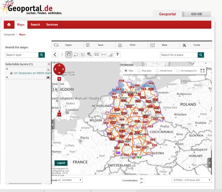
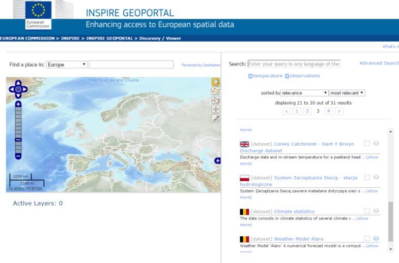
5 Data access via Geoportals


6 ADAGUC Combining INSPIRE view services & time adaguc.knmi.nl
7 ECMWF Copernicus C3S and CAMS
 depending on national policies.")
8 EUMETNET Members : challenges Feedback about User Expectations and usage of our community s INSPIRE datasets and services could be improved Even with harmonized datasets, contents will be different from one Member States to the other (parameters, time/spatial resolution) depending on national policies. Discovery and integration of data is hampered because of multilingual free text keywords (metadata) and the absence of or unknown code lists (data models). Usage of standard vocabularies and code lists should improve (e.g. NetCDF/CF). National and EU geoportals do not support the time dimension of view services (OGC-WMS) according to the INSPIRE specifications. Viewing the time dimension is important and solutions are available (e.g. ADAGUC). National and EU geoportals do not support dataset restrictions according to INSPIRE specification. This hampers the effective implementation of data security.
9 EUMETNET / ECOMET Members : Data policy challenges INSPIRE is one of several European Directives Governing European Met Service operations European Met Services also comply with World Meteorological Organisation (WMO) Resolutions Data availability is generally governed by the PSI Directive All EU Countries have different data policies From Open Data through a range of Charging Policies With a trend towards Open Data
10 EUMETNET Members : Outlook INSPIRE activity will grow Because most Members need to harmonize their datasets. More collaboration between Members (exchanging knowledge, sharing best practices and solutions) Usage of INSPIRE services is expected to increase : the need to exploit multi-disciplinary data is driving innovation Data policies are slowly evolving thus increasing the number of freely accessible datasets
11 Contact details : Eric Petermann, Exec. Director EUMETNET eric.petermann@eutmetnet.eu Willie McCairns, Chief Exec ECOMET willie.mccairns@meteo.be Jan-Willem Noteboom, INSPIRE WG Chair janwillem.noteboom@knmi.nl
INSPIREd solutions for Air Quality problems Alexander Kotsev
 INSPIREd solutions for Air Quality problems Alexander Kotsev www.jrc.ec.europa.eu Serving society Stimulating innovation Supporting legislation The European data puzzle The European data puzzle 24 official
ArcGIS for INSPIRE. Marten Hogeweg
 ArcGIS for INSPIRE Marten Hogeweg Please Take Our Survey on the App Download the Esri Events app and find your event Select the session you attended Scroll down to find the feedback section Complete answers
Climate Change Service
 Service Metadata for the Data Store Dick Dee, ECMWF C3S: data + expertise + operational Open and free access to climate data (observations, reanalyses, model predictions) Tools and best scientific practices
Open Data meets Big Data
 Open Data meets Big Data Max Craglia, Sven Schade, Anders Friis European Commission Joint Research Centre www.jrc.ec.europa.eu Serving society Stimulating innovation Supporting legislation JRC is Technical
ADVANTAGES OF GIS-INTEGRATED MARITIME DATA IN THE BLACK SEA REGION FOR MULTIPURPOSE USE
 INTERAGENCY INTERACTION IN CRISIS MANAGEMENT AND DISASTER RESPONSE 2017 ADVANTAGES OF GIS-INTEGRATED MARITIME DATA IN THE BLACK SEA REGION FOR MULTIPURPOSE USE Lyubka Pashova 1, Anna Kortcheva 2, Vasko
INSPIRE Directive. Status June 2007
 INSPIRE Directive INfrastructure for SPatial InfoRmation in Europe Status June 2007 European Commission Directorate-General Environment Research, Science and Innovation Unit Rue de la Loi, 200 1049 Brussels
The Copernicus Climate Change (C3) service: State of play
 service: State of play") Enterprise and Industry The Copernicus Climate Change (C3) service: State of play B. Pinty (a) & J-N. Thépaut (b) (a) Copernicus G.2 unit (b) ECMWF CCI October2014 Legal frame & MS consultations Publica6on
Enterprise and Industry The Copernicus Climate Change (C3) service: State of play B. Pinty (a) & J-N. Thépaut (b) (a) Copernicus G.2 unit (b) ECMWF CCI October2014 Legal frame & MS consultations Publica6on
Report on the establishment of UN GGIM: Europe Item 14. 4th session of the Committee of Experts on UN-GGIM
 Report on the establishment of UN GGIM: Europe Item 14 1 Why regional European committees of UN GGIM? In the ECOSOC resolution 2011/24 on the UN GGIM: Emphasizes the importance of promoting national, regional
INSPIRE Basics. Vlado Cetl European Commission Joint Research Centre. https://ec.europa.eu/jrc/
 INSPIRE Basics Vlado Cetl European Commission Joint Research Centre https://ec.europa.eu/jrc/ Serving society Stimulating innovation Supporting legislation Outline SDI? Why European SDI? INSPIRE Policy
EXPECTATIONS OF TURKISH ENVIRONMENTAL SECTOR FROM INSPIRE
 EXPECTATIONS OF TURKISH ENVIRONMENTAL SECTOR FROM INSPIRE June, 2010 Ahmet ÇİVİ Tuncay DEMİR INSPIRE in the Eyes of MoEF Handling of Geodata by MoEF Benefits Expected TEIEN First Steps for INSPIRE Final
Proposal for a DIRECTIVE OF THE EUROPEAN PARLIAMENT AND OF THE COUNCIL. establishing an infrastructure for spatial information in the Community
 Proposal for a DIRECTIVE OF THE EUROPEAN PARLIAMENT AND OF THE COUNCIL establishing an infrastructure for spatial information in the Community INSPIRE http://inspire.jrc.it/ Alessandro Annoni 1 EU Commission
ArcGIS for INSPIRE. Marten Hogeweg Satish Sankaran
 ArcGIS for INSPIRE Marten Hogeweg Satish Sankaran Outline What is ArcGIS ArcGIS for INSPIRE Web GIS Case Studies Roadmap Q&A What is INSPIRE? INSPIRE is the legal framework for a European Spatial Data
Infrastructure for Spatial Information in Europe (INSPIRE) Steve Peedell
 Steve Peedell") Infrastructure for Spatial Information in Europe (INSPIRE) Steve Peedell European Commission DG Joint Research Centre Institute for Environment and Sustainability ESDI Action Overview JRC, European Commission
Infrastructure for Spatial Information in Europe (INSPIRE) Steve Peedell European Commission DG Joint Research Centre Institute for Environment and Sustainability ESDI Action Overview JRC, European Commission
a national geological survey perspective François ROBIDA BRGM (French Geological Survey)
") a national geological survey perspective François ROBIDA BRGM (French Geological Survey) Pre-Conference Seminar on Socio-Economic Value of Geospatial for National and Regional Development 21 August 2017,
a national geological survey perspective François ROBIDA BRGM (French Geological Survey) Pre-Conference Seminar on Socio-Economic Value of Geospatial for National and Regional Development 21 August 2017,
Status of implementation of the INSPIRE Directive 2016 Country Fiches. COUNTRY FICHE Malta
 Status of implementation of the INSPIRE Directive 2016 Country Fiches COUNTRY FICHE Malta Introduction... 1 1. State of Play... 2 1.1 Coordination... 2 1.2 Functioning and coordination of the infrastructure...
EuroGeographics & INSPIRE. Nick Land, Executive Director of EuroGeographics
 EuroGeographics & INSPIRE Nick Land, Executive Director of EuroGeographics EuroGeographics A growing association 49 Members, 42 countries Topographic mapping, cadastre, land registry + Networked organisation
INSPIRing Geospatial Framework For Local Administrations
 This project is financed by the European Union and the Republic of Turkey Presented at the FIG Congress 2018, May 6-11, 2018 in Istanbul, Turkey National Programme for Turkey 2010 Instrument for Pre-Accession
A BRIEF INTRODUCTION TO COPERNICUS AND CAMS
 A BRIEF INTRODUCTION TO COPERNICUS AND CAMS Juan Garcés de Marcilla Director of Copernicus Services European Centre for Medium-Range Weather Forecasts Copernicus EU Copernicus EU Copernicus EU www.copernicus.eu
econtentplus GS Soil
 econtentplus GS Soil General aims Assessment and strategic development of INSPIRE compliant Geodata-Services for European Soil Data BPN on basis of the EU 2007/2/EC (INSPIRE) Directive for Annex III theme
SITMUN: Cooperating to Build Local SDIs in the Barcelona Region
 SITMUN: Cooperating to Build Local SDIs in the Barcelona Region Diputació de Barcelona Territory and Sustainability Area Territorial Information Systems Department INSPIRE CONFERENCE Barcelona, September
INSPIRE. Data Specification for Meteorology. Bruce Wright, Expert Strategic Advisor (Data Management)
") INSPIRE Data Specification for Meteorology Bruce Wright, Expert Strategic Advisor (Data Management) Third Workshop on the use of GIS/OGC Standards in Meteorology- 15 November 2010 Table of Contents INSPIRE
INSPIRE Data Specification for Meteorology Bruce Wright, Expert Strategic Advisor (Data Management) Third Workshop on the use of GIS/OGC Standards in Meteorology- 15 November 2010 Table of Contents INSPIRE
The Process of Spatial Data Harmonization in Italy. Geom. Paola Ronzino
 The Process of Spatial Data Harmonization in Italy Geom. Paola Ronzino ISSUES Geospatial Information in Europe: lack of data harmonization the lack of data duplication of data CHALLENGES Challenge of INSPIRE:
ESBN. Working Group on INSPIRE
 ESBN Working Group on INSPIRE by Marc Van Liedekerke, Endre Dobos and Paul Smits behalf of the WG members WG participants Marc Van Liedekerke Panos Panagos Borut Vrščaj Ivana Kovacikova Erik Obersteiner
Conceptual Modelling within The OGC MetOcean Domain Working Group
 Conceptual Modelling within The OGC MetOcean Domain Working Group 21 st EGOWS Mtg, 1 st -4 th June 2010, ECMWF Dominic Lowe, dominiclowe@stfc.ac.uk British Atmospheric Data Centre, http://badc.nerc.ac.uk
Interoperability of Spatial Planning Data
 INSPIRE Conference 2010, Krakow, Poland Interoperability of Spatial Planning Data European Network of Best Practices for Interoperability of Spatial Planning Information Tomas Mildorf mildorf@centrum.cz
Harmonisation of Spatial Planning Data
 INSPIRE Conference 18 June 2011 Edinburgh, Great Britain Harmonisation of Spatial Planning Data Tomas Mildorf University of West Bohemia mildorf@centrum.cz Pilsen, Czech Republic Co-funded by the Community
Status of implementation of the INSPIRE Directive 2016 Country Fiches. COUNTRY FICHE Denmark
 Status of implementation of the INSPIRE Directive 2016 Country Fiches COUNTRY FICHE Denmark Introduction... 1 1. State of Play... 2 1.1 Coordination... 2 1.2 Functioning and coordination of the infrastructure...
US National Spatial Data Infrastructure A Spatial Framework for Governance and Policy Development to Enable a Location-Based Digital Ecosystem
 GeoPlatform Workshop 7 Dec 2016, Department of the Interior Washington, D.C. US National Spatial Infrastructure A Spatial Framework for Governance and Policy Development to Enable a Location-Based Digital
Spatially Enabled Society
 International Seminar on Land Administration Trends and Issues in Asia and the Pacific Region Spatially Enabled Society Abbas Rajabifard Vice Chair PCGIAP-WG3 Vice-President (President Elect), GSDI Association
Status of implementation of the INSPIRE Directive 2016 Country Fiches. COUNTRY FICHE Czech Republic
 Status of implementation of the INSPIRE Directive 2016 Country Fiches COUNTRY FICHE Czech Republic Introduction... 1 1. State of Play... 2 1.1 Coordination... 2 1.2 Functioning and coordination of the
Collaborative Systems for the Creation of Marine Services
 Collaborative Systems for the Creation of Marine Services INSPIRE 2016 Nuno Almeida Nuno Catarino Barcelona, 28 th September 2016 Elecnor Deimos is a trademark which encompasses Elecnor Group companies
INSPIRE implementation in the Turkish Ministry of Environment and Urbanization Producing and Publishing Environmental Data
 INSPIRE implementation in the Turkish Ministry of Environment and Urbanization Producing and Publishing Environmental Data Ezgi Sarmusak Urban Planner, MoEU Sibel Süer Toybıyık - Assistant Expert, MoEU
Tomas Mildorf, Karel Janecka University of West Bohemia in Pilsen Czech Republic
 European Network of Best Practices for Interoperability of Spatial Planning Information Tomas Mildorf, Karel Janecka mildorf@centrum.cz, kjanecka@kma.zcu.cz University of West Bohemia in Pilsen Czech Republic
The WMO Global Basic Observing Network (GBON)
") The WMO Global Basic Observing Network (GBON) A WIGOS approach to securing observational data for critical global weather and climate applications Robert Varley and Lars Peter Riishojgaard, WMO Secretariat,
The WMO Global Basic Observing Network (GBON) A WIGOS approach to securing observational data for critical global weather and climate applications Robert Varley and Lars Peter Riishojgaard, WMO Secretariat,
INSPIRE - A Legal framework for environmental and land administration data in Europe
 INSPIRE - A Legal framework for environmental and land administration data in Europe Dr. Markus Seifert Bavarian Administration for Surveying and Cadastre Head of the SDI Office Bavaria Delegate of Germany
Infrastructure for Spatial Information in Europe (INSPIRE)
") Infrastructure for Spatial Information in Europe (INSPIRE) 2011 GISCO Working Party 8-9.3.2012 INSPIRE is about improving access to spatial information: the environment doesn t stop at borders EU Geoportal
Infrastructure for Spatial Information in Europe (INSPIRE) 2011 GISCO Working Party 8-9.3.2012 INSPIRE is about improving access to spatial information: the environment doesn t stop at borders EU Geoportal
Status of implementation of the INSPIRE Directive 2016 Country Fiches. COUNTRY FICHE Netherlands
 Status of implementation of the INSPIRE Directive 2016 Country Fiches COUNTRY FICHE Netherlands Introduction... 1 1. State of Play... 2 1.1 Coordination... 2 1.2 Functioning and coordination of the infrastructure...
Turkey s National SDI Implementation
 Onur PAŞAOĞULLARI Head of Department Turkey s National SDI Implementation Presentation Plan NSDI Background General Directorate of Geographic Information Systems NSDI Project INSPIRE Directive Urban Information
Status of implementation of the INSPIRE Directive 2016 Country Fiches. COUNTRY FICHE Ireland
 Status of implementation of the INSPIRE Directive 2016 Country Fiches COUNTRY FICHE Ireland Introduction... 1 1. State of Play... 2 1.1 Coordination... 2 1.2 Functioning and coordination of the infrastructure...
Status of implementation of the INSPIRE Directive 2016 Country Fiches. COUNTRY FICHE France
 Status of implementation of the INSPIRE Directive 2016 Country Fiches COUNTRY FICHE France Introduction... 1 1. State of Play... 2 1.1 Coordination... 2 1.2 Functioning and coordination of the infrastructure...
WMO Integrated Global Observing Systems (WIGOS) and the QA4EO
 and the QA4EO") WMO OMM World Meteorological Organization Working together in weather, climate and water WMO Integrated Global Observing Systems (WIGOS) and the QA4EO J. Lafeuille WMO Space Programme WMO www.wmo.int Outline
WMO OMM World Meteorological Organization Working together in weather, climate and water WMO Integrated Global Observing Systems (WIGOS) and the QA4EO J. Lafeuille WMO Space Programme WMO www.wmo.int Outline
INSPIRE General Introduction & Service Architecture
 INSPIRATION Spatial Data Infrastructure in the Western Balkans INSPIRE General Introduction & Service Architecture 1st National INSPIRATION Workshop Croatia November 21-22, 2012 A multi-countryprojectfunded
NWC-SAF Satellite Application Facility in Support to Nowcasting and Very Short Range Forecasting
 NWC-SAF Satellite Application Facility in Support to Nowcasting and Very Short Range Forecasting Marianne König Slide 1 Satellite Application Facilities (SAFs) in Europe Member State Cooperating State
Key Points Sharing fosters participation and collaboration Metadata has a big role in sharing Sharing is not always easy
 Sharing Resources Geoff Mortson esri, Inc. SDI Solutions Team Key Points Sharing fosters participation and collaboration Metadata has a big role in sharing Sharing is not always easy Data Sharing is Good
Discovery and Access of Geospatial Resources using the Geoportal Extension. Marten Hogeweg Geoportal Extension Product Manager
 Discovery and Access of Geospatial Resources using the Geoportal Extension Marten Hogeweg Geoportal Extension Product Manager DISCOVERY AND ACCESS USING THE GEOPORTAL EXTENSION Geospatial Data Is Very
The WMO Global Basic Observing Network (GBON)
") The WMO Global Basic Observing Network (GBON) A WIGOS approach to securing observational data for critical global weather and climate applications Robert Varley and Lars Peter Riishojgaard, WMO Secretariat,
The WMO Global Basic Observing Network (GBON) A WIGOS approach to securing observational data for critical global weather and climate applications Robert Varley and Lars Peter Riishojgaard, WMO Secretariat,
Status of implementation of the INSPIRE Directive 2016 Country Fiches. COUNTRY FICHE Croatia
 Status of implementation of the INSPIRE Directive 2016 Country Fiches COUNTRY FICHE Croatia Introduction... 1 1. State of Play... 2 1.1 Coordination... 2 1.2 Functioning and coordination of the infrastructure...
Providing Marine Data. The German Marine Data Infrastructure (MDI-DE) as an example for best practice
 as an example for best practice") Providing Marine Data The German Marine Data Infrastructure (MDI-DE) as an example for best practice Data Originators 18 Agencies and Institutions in the EEZ and 12 Mile Zone Federal Government BSH Schleswig-Holstein
Providing Marine Data The German Marine Data Infrastructure (MDI-DE) as an example for best practice Data Originators 18 Agencies and Institutions in the EEZ and 12 Mile Zone Federal Government BSH Schleswig-Holstein
Meteorological instruments and observations methods: a key component of the Global Earth Observing System of Systems (GEOSS)
") GLOBAL OBSERVING SYSTEMS Instruments and Methods of Observation Programme Meteorological instruments and observations methods: a key component of the Global Earth Observing System of Systems (GEOSS) Dr.
GLOBAL OBSERVING SYSTEMS Instruments and Methods of Observation Programme Meteorological instruments and observations methods: a key component of the Global Earth Observing System of Systems (GEOSS) Dr.
Inspire Marine OF and SR TWG Keiran Millard, Group Manager, SeaZone
 Inspire Marine OF and SR TWG Keiran Millard, Group Manager, SeaZone On behalf og the Inspire TWG OF+SR Keiran Millard, Marc Roesbeke, Hans Mose Jensen, Dominic Lowe, Alessandro Serratta, Nuria Hermida,
Progress of UN-GGIM: Europe Working Group A on Core Data
 INSPIRE KEN 13 December 2016 Progress of UN-GGIM: Europe Working Group A on Core Data François Chirié, Dominique Laurent, IGN France Plan Introduction Objectives of the working group with respect to INSPIRE
Recommendations from COST 713 UVB Forecasting
 Recommendations from COST 713 UVB Forecasting UV observations UV observations can be used for comparison with models to get a better understanding of the processes influencing the UV levels reaching the
Estonian approach to implementation of INSPIRE directive. Sulev Õitspuu Head of Bureau of Geoinfosystems Estonian Land Board
 Estonian approach to implementation of INSPIRE directive Sulev Õitspuu Head of Bureau of Geoinfosystems Estonian Land Board 13.06.2016 Contents - INSPIRE coordination in Estonia - INSPIRE implementation
Appropriation Directions for 2007
 INSPIRE in Sweden An Important Part of the National Geodata Strategy Monica Lagerqvist Nilsson Appropriation Directions for 2007 A commission to investigate the necessity to adjust the Swedish legislation
C o p e r n i c u s a n d W I G O S
 C o p e r n i c u s a n d W I G O S Jean-Noël Thépaut & Mark Dowell 24 October 2017 GEO XIV, Washington DC, 23-28 October 2017 T h e C o p e r n i c u s P r o g r a m m e Copernicus is the European Union
Implementing the Smart Growth Priority in an Open and Interoperable System for Geographic Data: Sardinia SITR- IDT
 REGION OF SARDINIA (ITALY) LOCAL AUTHORITY FOR MUNICIPALITIES, FINANCES AND URBAN PLANNING DEPT. FOR THE REGIONAL SPATIAL DATA INFRASTRUCTURE Implementing the Smart Growth Priority in an Open and Interoperable
THE CLIMATE INFORMATION MODULE
 Climate Information and Prediction Services (CLIPS) -Curriculum- THE CLIMATE INFORMATION MODULE designed by Dipl.-Met. Peer Hechler Deutscher Wetterdienst P.O. Box 10 04 65 63004 Offenbach Germany THE
Roadmap to interoperability of geoinformation
 Roadmap to interoperability of geoinformation and services in Europe Paul Smits, Alessandro Annoni European Commission Joint Research Centre Institute for Environment and Sustainability paul.smits@jrc.it
Opportunities and Risks National Responses Austria Aeronautical MET Services -Part of an ATC Provider
 Opportunities and Risks National Responses Austria Aeronautical MET Services -Part of an ATC Provider AUSTRO CONTROL is the former Federal Office of Civil Aviation. is a company with limited liability.
New COST Action: Towards a European Network on Chemical Weather Forecasting and Information Systems
 New COST Action: Towards a European Network on Chemical Weather Forecasting and Information Systems Proposer: Mikhail Sofiev Finnish Meteorological Institute Historical background EUMETNET Workshop on
EUMETSAT s Support to Climate Services and User Support. Joachim Saalmüller
 EUMETSAT s Support to Climate Services and User Support Joachim Saalmüller 1 User Forum in Africa September 2016 Outline of my talk EUMETSAT in support of climate services Exploring our data and subscribing
Steve Colwell. British Antarctic Survey
 Global Climate Observing System (GCOS) Steve Colwell British Antarctic Survey Goal and Structure of GCOS The Goal of GCOS is to provide continuous, reliable, comprehensive data and information on the state
The Swedish National Geodata Strategy and the Geodata Project
 The Swedish National Geodata Strategy and the Geodata Project Ewa Rannestig, Head of NSDI Co-ordination Unit, Lantmäteriet, ewa.rannstig@lm.se Ulf Sandgren, Project Manager Geodata Project, Lantmäteriet,
SWEDISH SDI DEVELOPMENT & IMPLEMENTATION OF INSPIRE
 SWEDISH SDI DEVELOPMENT & IMPLEMENTATION OF INSPIRE Christina Wasström, Lantmäteriet, 801 82 Gävle, Sweden, christina.wasstrom@lm.se ABSTRACT The Swedish Government and Parliament has given Lantmäteriet
Progress of UN-GGIM: Europe Working Group A on Core Data
 PolicyKEN Budapest 29 November 2016 Progress of UN-GGIM: Europe Working Group A on Core Data François Chirié, Dominique Laurent, IGNF Core data context Background and purpose Aim of Work Group A to propose
INSPIRE implementation in Portugal: the operational approach
 INSPIRE implementation in Portugal: the operational approach REIS, Rui; SANTOS, Ana Sofia; FONSECA, Alexandra; SILVA, Henrique; GOMES, Ana Luisa; FURTADO, Danilo; GEIRINHAS, João rui.reis@igeo.pt AGENDA
Global Geospatial Information Management Country Report Finland. Submitted by Director General Jarmo Ratia, National Land Survey
 Global Geospatial Information Management Country Report Finland Submitted by Director General Jarmo Ratia, National Land Survey Global Geospatial Information Management Country Report Finland Background
State of the Art. in Spatial Planning Data Harmonisation & Spatial Data Infrastructure (SDI) Julia Neuschmid, CEIT ALANOVA
 Julia Neuschmid, CEIT ALANOVA") INSPIRE Conference, June 2010, Krakow State of the Art in Spatial Planning Data Harmonisation & Spatial Data Infrastructure (SDI) Julia Neuschmid, CEIT ALANOVA Co-funded by the Community programme econtentplus
INSPIRE Conference, June 2010, Krakow State of the Art in Spatial Planning Data Harmonisation & Spatial Data Infrastructure (SDI) Julia Neuschmid, CEIT ALANOVA Co-funded by the Community programme econtentplus
EMODnet High Resolution Seabed Mapping - further developing and providing a high resolution digital bathymetry for European seas
 EMODnet High Resolution Seabed Mapping - further developing and providing a high resolution digital bathymetry for European seas EGU Fall 2017 meeting New Orleans USA, December 2017 Schaap Dick MARIS,
Climate Data Records (CDR) provided by CM SAF. Martin Werscheck Deutscher Wetterdienst
 provided by CM SAF. Martin Werscheck Deutscher Wetterdienst") Climate Data Records (CDR) provided by CM SAF Martin Werscheck Deutscher Wetterdienst CM SAF: EUMETSAT Satellite Application Facility on Climate Monitoring GCOS SCIENCE DAY IMPORTANCE OF THE CLIMATE OBSERVATIONS
Climate Data Records (CDR) provided by CM SAF Martin Werscheck Deutscher Wetterdienst CM SAF: EUMETSAT Satellite Application Facility on Climate Monitoring GCOS SCIENCE DAY IMPORTANCE OF THE CLIMATE OBSERVATIONS
Marine Spatial Management Tool
 Marine Spatial Management Tool Marine Spatial Management Tool Support the marine spatial planning process with updated and reliable geospatial information Marine management is important to Norway with
INSPIRATION results and benefits for the Agency for Real Estate Cadastre
 JOINT RESEARCH CENTER - E&I WORKSHOP INSPIRATION results and benefits for the Agency for Real Estate Cadastre Sonja Dimova, state advisor AGENCY FOR REAL ESTATE CADASTRE REPUBLIC OF MACEDONIA Wednesday,
GIS Building Communities beyond National Borders (Building Successful Spatial Data Infrastructures) Nick Land, ESRI Europe
 Nick Land, ESRI Europe") GIS Building Communities beyond National Borders (Building Successful Spatial Data Infrastructures) Nick Land, ESRI Europe UK worst flooding in the last 60 years 350,000 households without drinking water
GIS Building Communities beyond National Borders (Building Successful Spatial Data Infrastructures) Nick Land, ESRI Europe UK worst flooding in the last 60 years 350,000 households without drinking water
Horizontal Interoperability among National Geoportals of ES, FR, PT & AD
 Horizontal Interoperability among National Geoportals of ES, FR, PT & AD A. F. Rodríguez S. Mas, D. Richard, J. M. Nataf, D. Furtado, R. P. Julião, S. Pijuan, S. Alba 1 Next 15 minutes Intoduction 4 National
UNOFFICIAL TRANSLATION
 UNOFFICIAL TRANSLATION THE CROATIAN PARLIAMENT 1135 Pursuant to Article 89 of the Constitution of the Republic of Croatia, I hereby issue the DECISION PROMULGATING THE NATIONAL SPATIAL DATA INFRASTRUCTURE
IDEBarcelona: Cooperating for a Smart Region Infrastructure
 IDEBarcelona: Cooperating for a Smart Region Infrastructure Marta Codinachs Serra Diputació de Barcelona Territory and Sustainability Area Territorial Information Systems Department SMART CITY EXPO WORLD
CAMS. Vincent-Henri Peuch (ECMWF) Atmosphere Monitoring. Copernicus EU.
 Atmosphere Monitoring. Copernicus EU.") CAMS COPERNICUS ATMOSPHERE M O NITO RING SERVICE Vincent-Henri Peuch (ECMWF) Copernicus EU Copernicus EU Copernicus EU www.copernicus.eu W H A T I S C O P E R N I C U S? Copernicus Copernicus is a flagship
CAMS COPERNICUS ATMOSPHERE M O NITO RING SERVICE Vincent-Henri Peuch (ECMWF) Copernicus EU Copernicus EU Copernicus EU www.copernicus.eu W H A T I S C O P E R N I C U S? Copernicus Copernicus is a flagship
SAON. Finnish Perspectives
 SAON Finnish Perspectives Challenges and opportunities Kari Laine THULE institute University of Oulu Finnish Perspectives: Challenges and opportunities Northern Long-Term Socio-Ecological Research Platform
Status of implementation of the INSPIRE Directive 2016 Country Fiches. COUNTRY FICHE Portugal
 Status of implementation of the INSPIRE Directive 2016 Country Fiches COUNTRY FICHE Portugal Introduction... 1 1. State of Play... 2 1.1 Coordination... 2 1.2 Functioning and coordination of the infrastructure...
INSPIRE Implementation in Estonia using ArcGIS
 INSPIRE Implementation in Estonia using ArcGIS Sulev Õitspuu Head of Bureau of Geoinfosystems Estonian Land Board 26.09.2016 Population: 1,3 million (69% Estonians) Area: 45,339 km 2 15 counties Estonia
Weather Information for Europe 3 May 2018
 Weather Information for Europe 3 May 2018 Weatherproofing the network A collaborative approach Jaakko Nuottokari EUMETNET WG AVIMET Chair Head of Aviation and Defence Finnish Meteorological Institute Jaakko.Nuottokari@fmi.fi
Arctic Observing Systems Challenges, New opportunities and Integration
 Arctic Observing Systems Challenges, New opportunities and Integration Japan Norway Arctic Science Week 03 June 2016 By Stein Sandven, NERSC Building an integrated Arctic Observing System Need to collect,
Standards in support of UN-GGIM and sustainable development
 2 nd High 2Level nd High Forum Level on GGIM, Forum QNCC, on GGIM Doha, Qatar, 6 February 2013 QNCC, Doha, Qatar, 6 February 2013 Standards in support of UN-GGIM and sustainable development Olaf Østensen
INSPIRE Shared Service
 INSPIRE Shared Service Creation and operation out of the box Petra Fritz (HZD), Michael Voigtländer (Esri Deutschland GmbH) INSPIRE Shared Service Agenda HZD backbone for a geodata infrastructure Implementing
WMO Space Programme: anticipated evolution and a Picture of Development of a Vision of WIGOS Space-based Component in 2040
 WMO Space Programme: anticipated evolution and a Picture of 2040 --Development of a Vision of WIGOS Space-based Component in 2040 Wenjian Zhang Director, Observing and Information Systems Department &
OPERA: Operational Programme for the Exchange of Weather Radar Information
 OPERA: Operational Programme for the Exchange of Weather Radar Information ALADIN-HIRLAM workshop, Toulouse Maud Martet 26-28 April 2016 OPERA: An EUMETNET Project EUMETNET: EIG of 31 European National
ECCC. Environment and Climate Change Canada. Organization contact. Paul Pestieau.
 ECCC Environment and Climate Change Canada http://www.ec.gc.ca Organization contact Paul Pestieau paul.pestieau@canada.ca Other contact 613-990-6855 Areas of contribution User-aspects and verification
New EU efforts to assess the state of the marine environment: the EMODnet Chemistry pilot project
 New EU efforts to assess the state of the marine environment: the EMODnet Chemistry pilot project Matteo Vinci and Alessandra Giorgetti, OGS NODC group, OCE September 2013 - IMDIS 2013, Lucca Overview
Agrometeorological services in Greece
 Eleftheria Tsiniari Hellenic National Meteorological Service Operational Forecaster MSc in Meteorology MSc in Prevention and Management of Natural Disasters Email: elefth.tsiniari@gmail.com 1 Past (last
Global Weather Enterprise
 Global Weather Enterprise Data policy today and tomorrow Michael Staudinger Zentralanstaltfür Meteorologieund Geodynamik Global Weather Enterprise WMO Resolution 40 1995 Urges Members to: Members shall
The Polar Data Landscape
 The Polar Data Landscape Polar Data Activities, Models and Issues from Local to Global Peter L. Pulsifer, NSIDC, GCRC Carleton University Cameron Wilson, Natural Resources Canada (NRCan) Martha Paiz, Natural
Emerging Trends in Institutional Arrangements Europe - Finland
 Emerging Trends in Institutional Arrangements Europe - Finland Arvo Kokkonen Deputy Director General National Land Survey of Finland 1 Contents Facts about Finland National Land Survey of Finland European
EARLY WARNING SYSTEM AND THE ROLE OF METEOROLOGICAL AND HYDROLOGICAL SERVICE CROATIA
 EARLY WARNING SYSTEM AND THE ROLE OF METEOROLOGICAL AND HYDROLOGICAL SERVICE CROATIA Meteorological and Hydrological Service National Protection and Rescue Directorate B. Ivančan an-picek V. Stajčić Establishment
WMO Priorities and Perspectives on IPWG
 WMO Priorities and Perspectives on IPWG Stephan Bojinski WMO Space Programme IPWG-6, São José dos Campos, Brazil, 15-19 October 2012 1. Introduction to WMO Extended Abstract The World Meteorological Organization
Spatially enabling e-government through geo-services
 Spatially enabling e-government through geo-services Mauro Salvemini EUROGI PRESIDENT Professor at Sapienza Università di Roma (IT) 1 About the presentation Few information about Eurogi ; Some essential
European Directive (2007/2/EC) INSPIRE sharing data in an interoperable way
 INSPIRE sharing data in an interoperable way") European Directive (2007/2/EC) INSPIRE sharing data in an interoperable way Robert Tomas 7 th European Conference on Regional Geoscientific Cartography and Information Systems Bologna, 12 th -15 th June
European Directive (2007/2/EC) INSPIRE sharing data in an interoperable way Robert Tomas 7 th European Conference on Regional Geoscientific Cartography and Information Systems Bologna, 12 th -15 th June
IHO STAKEHOLDERS FORUM. Hydrographic data and its role in MSDI. Thursday 27 September Jens Peter Hartmann KMS
 IHO STAKEHOLDERS FORUM Hydrographic data and its role in MSDI Thursday 27 September Jens Peter Hartmann KMS Agenda Traditional approach to hydrographic data Expectations within the marine / maritime field
The Copernicus Sentinel-5 Mission: Daily Global Data for Air Quality, Climate and Stratospheric Ozone Applications
 SENTINEL-5 The Copernicus Sentinel-5 Mission: Daily Global Data for Air Quality, Climate and Stratospheric Ozone Applications Yasjka Meijer RHEA for ESA, Noordwijk, NL 15/04/2016 Co-Authors: Jörg Langen,
Implementing strategy for the Infrastructure for Spatial Information in Europe - INSPIRE Paul Smits
 Implementing strategy for the Infrastructure for Spatial Information in Europe - INSPIRE Paul Smits European Commission DG Joint Research Centre Institute for Environment and Sustainability Ispra, Italy
ArcGIS for INSPIRE. Paul Hardy. ArcGIS. ArcGIS for INSPIRE Enables Esri ArcGIS users to implement and comply with INSPIRE. INSPIRE Data Themes
 Enables Esri ArcGIS users to implement and comply with INSPIRE Paul Hardy phardy@esri.com EuroGeographics INSPIRE KEN (Schema Transformation) 8/9 October 2013, Marne la Vallée INSPIRE Data Themes Annex