Geographical Names standardization in Africa: Challenges and constraints
|
|
|
- Catherine Rice
- 6 years ago
- Views:
Transcription
1 Geographical Names standardization in Africa: Challenges and constraints TASK TEAM FOR AFRICA Presenters: Brahim Atoui & Naima Friha 11th UNCSGN NEW YORK 7-17 AUGUST 2017
2 Geographical Names standardization in Africa: A decade of actions By Brahim Atoui: Convenor of Task Team for Africa
3 HISTORY Brief history : African Countries : Precursors in the establishment of structures for the standardization of geographical names: Liberia: Botswana: 1965-Cameroon : Malawi Zambia Tanzania 1981-Tunisia : 1983.
4 HISTORY The UN Group of Experts on the Standardization of Geographical Names, aware of the African specificity in toponymic matters whose languages are mainly derived from unwritten languages, was concerned at its first conference on toponymic issues in Africa.
5 TASK TEAM for AFRICA Establishment of a Task Team for Africa at the 23rd Session of GENUNG: Make a diagnosis Revitalizing a toponymic activity in Africa Suggest appropriate solutions for the promotion of geographical names Initiate appropriate actions.
6 DIAGNOSTIC Financial problems Distance from meeting venue, Lack of training of African skills in this field.
7 Very low participation in the GENUNG s work conferences Number of participating countries 1st Conference 9 2nd conference 4 3rd Conference 6 4 th Conference 10 5thConference 6 6 th Conference 10 7th Conference 15 8 th Conference 8 9 th Conference th Conference 13
8 Participation by country (From a total of 56 countries) 7 countries participated only once. 7 countries 2 times 6 countries 3 times 5 countries 4 times 3 countries 5 times
9 Countries with toponymic management structures Only 17 of the 56 countries in Africa have a structure in charge of toponymy management. They are often not very active and have very little human or material means.
10 Linguistic-Geographical Divisions Africa is divided into four linguistic-geographical divisions : The Eastern Division, the Central Division, the Western Division and the Division of South Africa. It should be reminded that Resolution No. 4 of the Second UNGEGN Conference made Africa a single Division Resolution 26 of the 3rd Conference reconfigured Africa into 3 Divisions : - The Western Division, regrouping 16 countries - The Central Division, regrouping 11 countries - The Eastern Division, regrouping 14 countries - By Resolution One of the 6th Conference, a fourth Division was added to that of South Africa.
11 North Africa Division? That of North Africa, which should include the Arab and Sahelian African countries, a homogeneous group with similar ethnic, cultural, linguistic and toponymic similarities, Does not yet constitute a division despite the aspiration of the countries of the region of the need for it.
12 North Africa Division? This action could not be materialized by the incomprehensible opposition of some new experts belonging to the Arab Division.
13 Activities of the Task Team for Africa in order to boost toponymic activity in Africa. 25 th Session of the GENUNG in Africa, 2009 Intership of Tunis 2007: Internship Organized with the assistance of the African Organization for Cartography and Remote Sensing and the Regional Center for Remote Sensing of the States of North Africa and the Tunisian National Center for Remote Sensing, under the aegis of the UNGEGN Training Working Group. It took place in Tunis with over 70 participants from 11 countries in Africa and the Arab world.
14 Activities of the Task Team for Africa in order to boost toponymic activity in Africa. Internship in Ouagadougou, from 4 to 8 August 2008, brought together trainees In particular from West African countries Internship in Nairobi: for East African Countries was also held in Nairobi from 1 to 3 May 2009 at the CRMCD on the margin of the 25th Session of UNGEGN;
15 Activities of the Task Team for Africa in order to boost toponymic activity in Africa. Internship in Yaounde / Cameroon: Training workshop on the standardization of geographical names, held in Yaoundé from 22 to 27 November 2010 with the collaboration of the GENUNG, thus allowing the revival of the Commission of Toponymy of Cameroon Internship of Antananarivo: held in Madagascar from 11 to 21 June 2013, with the collaboration of GENUNG, which also encouraged the dynamism of the Commission of toponymy of this country.
16 Activities of the Task Team for Africa in order to boost toponymic activity in Africa. Second Internship in Tunis: Another internship in Tunis from 12th to 16th January 2015 for the benefit of members of the newly created Tunisian National Committee of Toponymy. Internship in Oran / Algeria: Another seminar held in Oran, Algeria, for the benefit of Algerian researchers in Toponymy of the National Center for Research in Social and Cultural Anthropology, officials and communal administrators in charge of naming the places.
17 Activities of the Task Team for Africa in order to boost toponymic activity in Africa. Meeting of Constantine / Algeria: important scientific meeting was held in Constantine / Algeria, which saw the participation of all the countries of the Sahel (Mali, Chad, Niger, Burkina Faso) During which a recommendation was adopted by participating African countries, supporting the creation of a North African Division within UNGEGN.
18 Activities of the Task Team for Africa in order to boost toponymic activity in Africa. Another meeting is also planned in Algiers during the next International Book Fair where an national toponymy day has been celebrated for more than 3 years, with the participation of Experts in toponymy of South Africa as Country 'guest of honor' of this Fair and of Burkina Faso: the theme of this day will be devoted to the toponymy Arab-Berber-African.
19 Activities of the Task Team for Africa in order to boost toponymic activity in Africa. Finally, two international competitions were organized by the Task Team for Africa for the benefit of the African countries, which saw an important participation of applicants from different African countries and prizes were awarded to the winners.
20 Activities of the Task Team for Africa in order to boost toponymic activity in Africa. In addition to these activities, the Task Team has continually sensitized African organizations to promote the standardization of geographical names. His actions were crowned by the organization of a meeting of African countries under the aegis of the ECA / UN in Gaborone / Botswana, With the participation of UNGEGN, During which an ambitious plan of action called 'GAP' was adopted. This plan aims at a better management of toponymy in Africa and contains several recommendations.
21 Activities of the Task Team for Africa in order to boost toponymic activity in Africa. Moreover, through awareness-raising efforts of the Task Team for Africa, several Commissions have been reactivated and others have been created; This is particularly the case of: Tunisia, Burkina Faso, Mali, Benin and; soon; Niger with a very significant contribution from the Commission of French toponymy and IGN FI,
22 Despite his efforts, there is still a long way to go and several questions are current: What are the best mechanisms to put in place to increase the dynamism of the toponymic activity in Africa? How to activate different African geographical and linguistic divisions? How could the Economic Commission for Africa be further involved in the promotion and coordination of toponymic activity inafrica? How to implement the provisions of the GAP? What can UNGEGN do for Africa? How to ensure cooperation between the Task Team for Africa and UN-GGIM Africa? What could be the contribution of GGIM Africa to the promotion of geographical names in Africa?
23 Despite his efforts, There is still a long way to go and several questions are current: If important results have been achieved, further reflection will have to be carried out within the UNGEGN and the Task Team for Africa in order to achieve better Leading to other salutary initiatives. Despite these modest but nevertheless positive results, which remains beyond the expectations of our continent, we have to double our efforts and we have great hope for the support of the GENUNG at the TASK TEAM FOR AFRICA for more results.
24 Thank you for your attention
25 Geographical Names standardization in Africa: Attempts of standardization in Tunisia, Botswana, Burkina Faso and Madagascar By Naima Friha: UNGEGN vice chair

26 Case of Tunisia Prepared by: Naima Friha
27 Toponymic landscape in Tunisia The toponymic landscape in Tunisia is very heterogeneous and reflects the three millennia history of the country where several civilizations have lived and ruled. Other factors that also contributed to this complexity are: The bilingualism (the official use of the French language in parallel with the Arabic), The diglossia between the official Arabic and the dialects, The toponymy is generally twinned with the cartography which, in a high level, relies either on existing names inherited from colonial epoch or on the linguistically unskilled surveyors who collect the names from the field.

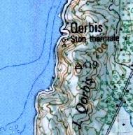

28 Examples of lack of standardization Different transcriptions for the same toponym Map of Korbous 1/ / (Beirut system 72)

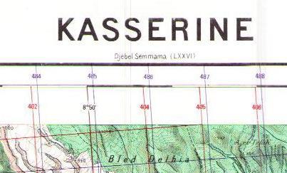
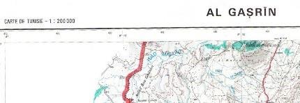
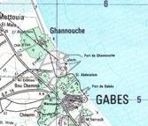
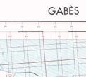
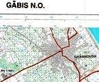
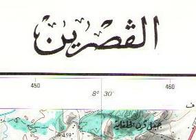
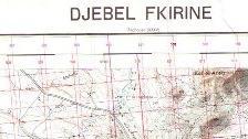
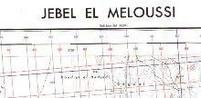
29 Examples of lack of standardization Different transcriptions for the same toponym Map of Kasserine 1/ / / Map of Gabes1/ / /25.000

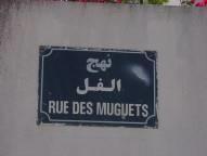
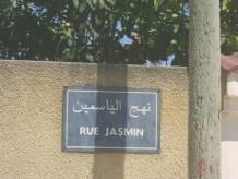
30 Examples of lack of standardization Doubtful/Poor Translation of Street Names


31 Examples of lack of standardization Commemorative naming use Rue Rue Rue Rue Rue Ancien nom Nouveau nom Rue Colonel Tahar Ayari Rue Lt. Kamel Chouaibi Rue Adjudant Major Lazhar Kthiri Rue Adjudant Major Ali Al Omrani Rue Adjudant Marin Sofien Ben Jammala
32 National standardization attempts 1. A unique system for the map production: The government tried since 1983, through the ex-national Mapping Agency (OTC) to set up a unique transcription system for its mapping production plan. A restricted commission of toponymy composed of experts and linguists representing three ministries (Ministry of National Defense, Ministry of Equipment, and Ministry of High Education and Scientific Research) was then created to study the amended Beirut 1972 transcription system. The Beirut 1972 transcription system, endorsed by the UNGEGN was then implemented by the OTC with few changes according to the Tunisian dialect, but few years after its informal ways of transcription. implementation, the map users found this system complex and confusing. The system was thus abandoned letting place to several other transcription systems.
33 National standardization attempts 2. Academic and scientific studies: Mme Evelyne Ben Jaafar, Linguist and author of : «Les noms des lieux en Tunisie: Racines vivantes de l'identité nationale» -CERES In her book she identifies different aspects relevant to the geographical names through their evolution in the history like the standardization in a multilingual environment and with regard to ideological and political contexts. Mr Mohsen Dhieb, Professor at the University of Arts and Humanities of Sfax : Developing, in the frame of the establishment of the National Atlas of Tunisia, a methodology to transcribe, on a medium scale administrative map, the Tunisian toponyms with the least possible errors.
34 National standardization attempts 3. Creation of the National Committee of Toponymy As implementation of the UNGEGN recommendations and resolutions and to regulate the toponymic sector in the country, the Centre National de la Cartographie et de la Télédétection (CNCT) worked fully committed to bring forward the emergency of geographical names' standardization. The creation of a National Toponymic Committee (NCT) was then seen as urgent solution. On 26th February 2013, the NCT was created by the Decree defining its composition, missions and functioning rules. Placed under the tutorship of the Ministry of National defense, the NCT is chaired by the minister of national defense and its secretariat is ensured by the CNCT

35 National Committee of Toponymy 1. Organizational chart : Tutorship: Ministry of National Defense President: Ministry of National Defense Secretariat: CNCT Members Prime ministry Ministry of agriculture culture Ministry of agriculture National Institute of statistics Ministry of interior Ministry of high education and research Ministry of environment Association of Tunisiens geographers Ministry of regional development and planning Ministry of industry National committee of military history Navy Centre of hydrography and oceanography Ministry of equipment Ministry of Commerce and Handicraft National Heritage Institute Tunisian post Ministry of transport Ministry of tourism Agency of topography and cadastre Association of expert surveyors National Centre for Cartography and remote sensing
36 National Committee of Toponymy 2. Missions: Collect, identify, control and correct geographical names. Control the translation of the names from Arabic to latin and their transcription and diffusion in particular on maps and road panels. Ensure the implementation of the Romanization system endorsed by UNGEGN. Ensure studies and researches about the historical, socio-economic, cultural and religious origins and meanings of geographical names including the exonyms.
37 National Committee of Toponymy 2. Missions: Ensure the setting up of gazetteers, atlases and toponymic databases. Look after ensuring the publication and distribution of books, researches, studies and articles about geographical names and use different media to raise people awareness about the importance of geographical names Ensure the necessary coordination between all bodies involved in geographical names Ensure the representation of the Republic of Tunisia at the regional and international events relevant to the field of geographical names.
38 National Committee of Toponymy 3. Activities: training course Organized by the Centre National de la Cartographie et de la Télédétection (CNCT) in collaboration with the United Nations Group of Experts on Geographical Names (UNGEGN), The United Nations Statistical Division (UNSD) essentially to train the newly appointed members of the committee, training course for the members of the committee covering a training session, a fieldwork and technical assistance to set a roadmap for the upcoming activities of the National Committee of Toponymy (NCT) was held from January 2015 in Tunis. The training session included lectures about geographical names issues reinforced by examples about the experiences in the field from participating countries with a glance on some toponymic achievements in Africa.


39 National Committee of Toponymy 3. Activities: workshop/training course 25 persons including 4 UNGEGN lecturers, 2 UNGEGN experts from Botswana and Burkina Faso and 19 members of the NCT, representing different ministries and national institutions attended the training.


40 3. Activities: Fieldwork National Committee of Toponymy Moderated by Madame Elisabeth Calvarin, the field work was conducted in the region of Ghar El Melh, situated 50kms north of the capital and known for its prestigious historical heritage and natural wealth. Procedures about toponymic field collection have been taught by Madame Calvarin.


41 National Committee of Toponymy 3. Activities: Fieldwork Assisted by a team from the National Heritage Institute (Ministry of Culture), place names origins, meanings and their evolution through centuries have been highlighted providing good opportunity to go in depth into the cultural heritage aspect of the area place names. Examples of names on road panels and unnamed places demonstrated the lack of standardization and data inconsistency in the region that may affect sectors like the tourism activity around those places.
42 National Committee of Toponymy 3. Activities/achievments: NCT Road map Official nomination of NCT members (Decision 26th January 2016): 21 members representing 12 ministries and 9 national agencies. Creation of 5 sub-committees (Decision: n April 2016): -Legislation and principles for naming, -Toponymy standardization and terminology glossary, -Toponymic databases, -Communication/sensitization and publication, -International cooperation and capacity building.
43 National Committee of Toponymy 3. Activities/achievments: NCT Road map Principles about naming places: Legal texts, names adopted by general use, historical names, linguistic forms and transliteration, use of persons names, naming selection criteria, spelling, recurring names, generic terminology, names abbreviation etc were defined. Survey: addressed to the ministries and bodies members of the NCT which objective is to scan the situation of GN names in the country and to get people opinion about the importance of GN standardization in their application fields. with reference to Article3 of the decree of the NCT creation, A Ministerial Circular recalling the obligation to take the committee agreement before any place name attribution was issued by the Prime ministry to all ministries concerned by the nomination. Collection of legal texts related to places naming.
44 National Committee of Toponymy 3. Activities/achievments: NCT Road map Logo of the NCT. Toponymic brochures (Arabic and french): describing the importance of standardized geographical names, the role of UNGEGN in that and advertizing about the NCT and its role in preserving the GN as cultural heritage. Creation of NCT website: created under the portal of the Ministry of National Defense, it will serve notably as a communication tool to set forth the GN issues, to report on the NCT activities and all related special events. Toponymic database: Based on 1/ scale maps and existing data, it has as first objective to solve and correct GN spelling both in Arabic and French languages. At second step, it has to be enriched to cover bigger scale maps in order to be used, notably, as reference for the on-going NGII, a challenging national project conducted by the CNCT.


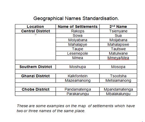
45 National Committee of Toponymy 3. Activities/achievments: NCT Road map
46 National Committee of Toponymy 4. Constraints Ministerial changes (merging, division, creation of new ministries ) entailed some changes on the NCT members. Consequently, people who not any more belong to the ministries members in the NCT are not any more willing to contribute to the NCT activities, or there is total absence of representatives for the new created ministries. Lack of committment of the members because of their own workload, Lack of information about the NCT rules (place naming often continues without consultation with the NCT), Lack of resources to hold training sessions, Lack of financial resources for meetings. the NCT members to attend UNGEGN
47 National Committee of Toponymy 4. Recommendations/Perspectives Despite the several discussions, it was seen that the only solution about the ministerial changes, is that the Decree of creation of the committee get revised at each change and that the revision takes into account the NCT members who have participated to the NCT since its creation [how?, how will this affect the work efficiency of the NCT?]. To facilitate interaction with the NCT members, the General Director of the Centre National de la Cartographie et de la Télédétection was appointed to act on behalf of the chair of the NCT for the majority of the NCT activities, An international workshop is planned for 2018.

48 Case of Botswana Prepared by : Lucy Phalaagae Lucyphala@hotmail.com
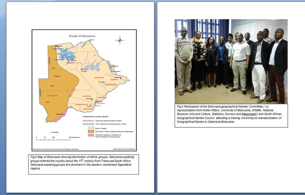
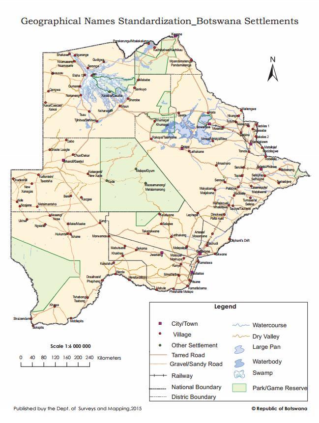
49 History- Botswana Place Names Commission (PNC) Botswana is a large country with an area of about square kilometers. Botswana has experienced a diversity of different languages and dialects. Due to this diversity of languages, the Surveyor General in 1965 proposed the establishment of a Place Names Commission. The Surveyor General was following precedence set by Survey Departments all over the world who had realized the need for an authoritative source of Place Names. This was to assist in publishing correct names and spellings of all topographic features in the country 49
50
51 . PNC Composition- Terms of Reference. Seven members from different parts of the country was appointed by the Minister of Local Government and lands. Appointment was based on their knowledge of South African linguistics, history of Botswana and Geographical Names of the country. A criteria on the examination of names was set to check local pronunciation, recognized meaning, etc. Meetings were broadcast by radio Botswana, through the kgotla (ward), district commissioners, tribal authorities and through village elders. 51
52 PNC Composition- Terms of Reference. The commission visited various villages to get first hand information on names. Visits triggered a lot of criticism on derivation and spelling of names. Young graduates from villages demanded to know more on why names on their villages were spelt wrongly. Disputes arose from other tribes who also felt their names were spelt wrongly. Due to these disputes PNC started negotiating for the enactment of an act. 52
53 New approaches - PNC The Department of Surveys and Mapping a national mapping agency has been the main coordinator of the PNC. The secretary and chairperson since 1990, became more involved by organizing meetings with relevant authorities. Meetings covered awareness on the consistent use of accurate place names. The secretary proposed to government that any meeting held they should be invited to talk about standardization of place names. Names were compiled and sent to various districts for correct spellings. The response has been positive. Names have been collected waiting for new committee to recommend. 53
54 Achievements in resuscitating the PNC The geographical Names Committee continues to pursue government to recognize that Presidential Directive does not carry much weight, an Act of Parliament will assist in enforcing requisite provisions. Committee has organized trained sessions to other government organizations on the importance of standardization of names. A draft cabinet memo has been compiled including proposed guiding structures. To give legislative authority to carry out mandate. All these achievements by the committee have been communicated to government. 54
55
56 Expectation/Recommendation Botswana Geographical Names committee to recommend to government correct spelling of all geographical features in the country. Efforts by University of Botswana on spelling of Setswana names. Documentation on the collected names during Botswana s 50th anniversary. Publication of names to give other organizations and general public on the use of official names. 56

57 Case of Burkina Faso Prepared by :Oumar Sanon

58 Toponymic Landscape in Burkina Faso General observation : toponyms or geographical names in Burkina Faso are characterized by a lack of homogeneity reflected in: 1. Broken links between old and current toponymic documents 2. Need for clarification between official language (French) and local languages, Ouagadougou Wogodogo (authentic name from the local language "mooré") SECACO Name given to the agglomeration formed around a former wood manufacturing company that no longer exists...
59 Toponymic Landscape in Burkina Faso 3. Probable misunderstanding of the transcription principles introduced since the 1960s : Adopted at the Bamako Conference (1963) Proposed to GENUNG in 1967 (1st Conference) Simplified in 1996 (Franco-African Seminar UNESCO - Paris) Revised at the Ouagadougou toponymy workshop in 2008 Faced with this situation, actions have been undertaken leading to : The creation of a first NTC in 1986 which has practically not functioned for reasons related to the inadequacy of national resources and expertise in the standardization of geographical names; Revitalization of the NTC s activities as part of the National Mapping Project at scale 1/200,000 with : capacity-building and creation of a new NTC by decree n /PRES/PM/MID/MATDS/MEF - December 30th, 2012
60 Missions and Organization of the Current NTC Missions of the current NTC Conduct an inventory and preserve place names; Adopt for each place name its official linguistic form; Develop the principles, methods and rules for the writing of all place names; Set criteria for the selection of the names to be assigned to places throughout the national territory; Disseminate the toponyms of Burkina Faso at national and international levels; Participate in international works on the preservation or reclaim the identity of the national toponymic heritage, a living fact of culture and language; Participate in international meetings and conferences on toponymy on behalf of Burkina Faso.
 and the Minister in charge of mapping (secretariat) ; The secretariat is")
61 Missions and Organization of the Current NTC The current NTC is composed of 13 statutory members and resource persons. It meets twice a year ; The NTC is under the supervision of the Minister in charge of Territorial Administration (Presidency) and the Minister in charge of mapping (secretariat) ; The secretariat is assisted by the Toponymy Office housed within the Geographical Institute of Burkina Faso; Members of the NTC were officially installed on March 15, 2013
62 Achievements of the NTC These achievements can be summarized as follows: Capacity building through : Holding of a regional toponymy workshop in Ouagadougou (2008) with input from UNGEGN experts ; Training of NTC s members on harmonization and standardization of toponyms (2012), as part of the National Mapping project at scale 1/200,000, Adoption of tools for the treatment of place names Harmonization tools Decomposition of place names (use of a glossary sketch in constant improvement) Charter of toponymy (upper case - lowercase / diacritical marks / hyphen / generic terms (glossary of terms in different languages Other rules (pronunciation - meaning / Simplification ("i" instead of "y") / Uniformity / Normal Standardization tools General principles of transcription into French language (Origin: Bamako Conference in 1963 toponyms of the French speaking countries in Africa) Some specific rules
63 Achievements of the NTC Adoption of specific rules for place names derived from Arabo-Berber languages for the names of the Sahelian zone : The groups "el" and èl" have the same pronunciation. Given the coexistence of these groups in the leaf toponyms of the Sahel region. (Diguel, Gorèl,...) The use of terminals t, m,..., avoiding the addition of a mute "e", which makes it possible to avoid contradictions in certain cases. (Tasmakat, Gorom-Gorom,...) Adoption of a sketch of a glossary of terms used in the main languages of Burkina Faso (to be updated continuously).
 of the topographic map 1/ 200,000 reviewed and validated between 2012 and 2014; Names of Administrative Entities (Region - Province - Municipality / Department : reviewed and validated; Orders")
64 Achievements of the NTC ~ toponyms (localities, hydronyms, oronyms,...) of the topographic map 1/ 200,000 reviewed and validated between 2012 and 2014; Names of Administrative Entities (Region - Province - Municipality / Department : reviewed and validated; Orders taken by authorities and adopting official toponyms; Consideration of validated toponyms in the updating of the directory of administrative localities in Burkina Faso; Consideration of the achievements in the treatment of toponyms in the process of erecting agglomerations into administrative localities. Participants in the 1st session of the NCT on February, 11 th 2014 in Fada-Ngourma (East region of Burkina Faso)
65 Main Difficulties These difficulties can be summarized as follows: The authorities' lack of commitment to assume financial responsibility for the NTC's activities - after the closure of the project, which enabled the revitalization and regular holding of sessions, the NTC has not been able to hold its regular sessions since 2015 ; Relative instability of NTC s members, which poses the need for continuous training in toponymy to ensure standardization of activities; Weak knowledge of the NTC and its missions at the national level, which does not favor its action in the long term ; Weak internal organization of the NTC, which does not promote its effectiveness on the ground.
66 Expectation/Recommendation Continuation of the activities to be included in the program of the Ministry in charge of Territorial Administration (NTC Presidency); Ongoing capacity building of the NTC s members; Organization of regular information and awareness campaigns on the NTC s missions and actions; Adoption of the NTC rules of procedures, specifying, among other things, the setting up of working groups; Capitalization on the achievements through the creation of a toponymic database and the updating of the Gazetteer of the country; Continuation of the standardization of the country's toponyms.

67 Case of Madagascar Prepared by : Nivo Ratovoarison nivoratovoarison@yahoo.com

68 Toponymic landscape in Madagascar Before 1973, the Geographical Service and then the National Institute for Geography and Hydrography (Foiben-Taosarintanin i Madagasikara - FTM) ensured the work on geographical names as a part of its mission. It consists on review of names included in 1: and 1: topographical maps through discussion with local authorities and experts. Obvious necessity of regulation in place naming: Some names are duplicated so many times that they cover the entire country ex of the 2 names with same meaning: New Town Tanambao (362) Antanambao (251) Some places have many names, bilingual or not, litigation related to history or culture.

69 A typical case: In a same map, 4 names for 1 place Fort-Dauphin Taolagnaro Tolanaro Faradofay

70 Creation of the National Committee of Toponymy After the United Nations Conference attended by the Director General of the FTM in Geneva in 1967, Madagascar began the challenge in implementation of recommendations and resolutions on geographical names standardization. The long procedure for creating a national committee on geographical names was then initiated. Thus the Komitim-Pirenena Miandraikitra ny Anarantany (KPMA) was established in 1973 by decree /06/73, amended by decree /03/2001. The KPMA is headquartered within the FTM.
71 Composition of the KPMA On the requests of existing ministries at that time, their 28 representatives joined 14 experts and linguists from University, Library, Archives, Academy to compose the 42 members of the KPMA. They are appointed by decree /05, The KPMA chair is the Ministry of Land and two vice-chairs are the Ministry of Interior and the Director General of the National Institute for Geography and Hydrography (FTM). The secretariat is assured by a representative of the FTM. The permanent bureau is composed by 8 persons: the Chair, the 2 Vice-chairs, the secretary, 4 members elected by the committee. The KPMA may request assistance from personalities with special expertise in toponymy as observer.
72 The KPMA is assigned to: Main functions of the KPMA study on the standardization of geographical names within the national territory and the procession of all questions related to geographical names that appear on all official publications and in maps in particular; contribute to the conservation and development of toponymic heritage; develop draft texts necessary for coherent and consistent actions in this domain
73 Work Process of the KPMA Make a prioritized list of ambiguous names to be standardized, frequently used in national and international communication (main towns, touristic places, capes, ) Carry out various researches: documentation, maps comparison, fieldwork including meetings with elected officials and local elders, with inhabitants when the name is subject of intense debate that is broadcasted eventually by local radio and recorded on a tape and moreover on paper signed by all the stakeholders. Compile an explanatory note including historical background and the reason guiding to the choice of each name. Launch a test through media, maps. If there is any critic, make more investigation Finally, the KPMA proposes a single name to the ministerial council.

74 Achievements of the KPMA 27 geographical names are standardized by decree , 28 March An International Training for Trainers has been organized in Antananarivo, June countries from East Africa have been represented and 28 persons received the knowledge. A first version of Toponymic Guidelines for Map and Other editors for International Use is to be presented during UNCSGN Toponymic documentation is available for the public at KPMA headquarter. Brochure and directive drafts are compiled and are waiting for validation.
75 Constraints of the KPMA Madagascar is a large country (4th largest island in the world, km²) thus, many existing names are duplicated, some are ambiguous, the KPMA is no corresponding entity in provinces, therefore, new places naming are not under control. The FTM was temporarily the main source of funding. Since 1995, financial problem occurred stopping: further standardization, further dissemination of standardized names. Change of government, retirement or transfer of members who then become out of touch, means new nomination that lead to long and repetitive procedure.
76 Expectation/Recommendation Government effective involvement in assistance of the KPMA in its duty : Funding meetings, researches, fieldtrips, Facilitate cooperation between governmental services in provinces to ensure naming control, Facilitate preservation of achievements by: continuous and large dissemination of standardized names, decree application.
77 THANK YOU FOR YOUR ATTENTION
7 TO 17 AUGUST 2017 NEW YORK. TASK TEAM FOR AFRICA by. Brahim Atoui : TTA, Convenor
 7 TO 17 AUGUST 2017 NEW YORK TASK TEAM FOR AFRICA by Brahim Atoui : TTA, Convenor Geographical Names standardization in Africa: Challenges and constraints A decade of actions BRIEF HISTORY African Countries
Toponymy workshop of Tunis: A road map to orient the activities of the national committee of toponymy
 UNITED NATIONS GROUP OF EXPERTS WORKING PAPER ON GEOGRAPHICAL NAMES NO. 33/8 Twenty-ninth session Bangkok, Thailand, 25 29 April 2016 Item 8 of the Provisional Agenda Activities relating to the Working
Geographical Names Activities in Africa The Gaborone Action Plan
 United Nations Group of Experts on Geographical Names Geographical Names Activities in Africa The Gaborone Action Plan 6 th Meeting of the Committee of Director -Generals of National Statistics Offices
Turkey National Report
 UNITED NATIONS Working Paper GROUP OF EXPERTS ON No. 26 GEOGRAPHICAL NAMES Twenty-third Session Vienna, 28 March 4 April 2006 Item 5 of the Provisional Agenda: Reports of the division Turkey National Report
United Nations Group Of Experts On Geographical Names
 Rudolph MATINDAS, Indonesia or William WATT, Australia Key words: place names, UNGEGN SUMMARY UNGEGN Discussing the strategic aims of UNGEGN and its divisional structure, future direction, and the benefits
Economic and Social Council
 United Nations Economic and Social Council Distr.: General 23 May 2012 Original: English E/CONF.101/100 Tenth United Nations Conference on the Standardization of Geographical Names New York, 31 July 9
Economic and Social Council
 United Nations Economic and Social Council Distr.: General 18 July 2016 Original: English Committee of Experts on Global Geospatial Information Management Sixth session New York, 3-5 August 2016 Item 2
LIST OF DOCUMENTS* GROUP OF EXPERTS ON GEOGRAPHICAL NAMES. Twenty-seventh session 15 June 2016 New York, 28 April 2 May 2014
 UNITED NATIONS GROUP OF EXPERTS ON GEOGRAPHICAL NAMES GEGN/29/5/Rev.4 Twenty-seventh session 15 June 2016 New York, 28 April 2 May 2014 LIST OF DOCUMENTS* * Prepared by the UNGEGN Secretariat Symbol Title/Country
E/CONF.105/158/CRP.158
 E/CONF.105/158/CRP.158 14 July 2017 Original: English Eleventh United Nations Conference on the Standardization of Geographical Names New York, 8-17 August 2017 Item 8 of the provisional agenda* Measures
Global Geospatial Information Management in Tunisia Situation and Future prospects
 Republic of Tunisia Ministry of National Defense National Mapping and Remote Sensing Center (NMRC) Global Geospatial Information Management in Tunisia Situation and Future prospects Qatar, February 2013
Resolutions from the Tenth United Nations Conference on the Standardization of Geographical Names, 2012, New York*
 UNITED NATIONS GROUP OF EXPERTS ON GEOGRAPHICAL NAMES Twenty-eighth session New York, 28 April 2 May 2014 GEGN/28/9 English Resolutions from the Tenth United Nations Conference on the Standardization of
Economic and Social Council
 United Nations Economic and Social Council Distr.: General 15 May 2012 Original: English E/CONF.101/4 Tenth United Nations Conference on the Standardization of Geographical Names New York, 31 July 9 August
ECONOMIC AND SOCIAL COUNCIL 13 July 2007
 UNITED NATIONS E/CONF.98/CRP.34 ECONOMIC AND SOCIAL COUNCIL 13 July 2007 Ninth United Nations Conference on the Standardization of Geographical Names New York, 21-30 August 2007 Item 17(b) of the provisional
Activities relating to the Working Group on Toponymic Data Files and Gazetteers*
 UNITED NATIONS WORKING PAPER GROUP OF EXPERTS NO. 10 ON GEOGRAPHICAL NAMES Twenty-seventh session 30 July and 10 August 2012, New York Item 3 of the Provisional Agenda Reports of the working groups Activities
UN-GGIM: An Overview Stefan Schweinfest, Director (UNSD) Bangkok, 27 March 2015
 Bangkok, 27 March 2015") UN-GGIM: An Overview Stefan Schweinfest, Director (UNSD) Bangkok, 27 March 2015 ggim.un.org UN-GGIM: A global initiative Formal inter-governmental UN Committee of Experts to: Discuss, enhance and coordinate
UN-GGIM: An Overview Stefan Schweinfest, Director (UNSD) Bangkok, 27 March 2015 ggim.un.org UN-GGIM: A global initiative Formal inter-governmental UN Committee of Experts to: Discuss, enhance and coordinate
Current Status of the Standardization of Geographical Names in Cambodia
 1 Current Status of the Standardization of Geographical Names in Cambodia His Excellency Ith Sotha, Under Secretary of States, MLMUPC Mr Chharom Chin, Deputy Director, Geography Department, MLMUPC Mr Narith
United Nations, UNGEGN, and support for national geographical names standardization programmes
 Philippines, 2018 United Nations, UNGEGN, and support for national geographical names standardization programmes Helen Kerfoot, UNGEGN Cecille Blake, UNGEGN Secretariat What is important to know? Background
UNESCO World Heritage Centre - Arab States Unit
 UNESCO World Heritage Centre - Arab States Unit Post-Conflict Reconstruction in the Middle East Context and in the Old City of Aleppo in Particular UNESCO Headquarter, 18-19 June 2015 ACTION PLAN resulting
Economic and Social Council 2 July 2015
 ADVANCE UNEDITED VERSION UNITED NATIONS E/C.20/2015/11/Add.1 Economic and Social Council 2 July 2015 Committee of Experts on Global Geospatial Information Management Fifth session New York, 5-7 August
African requirements for SDI standardization Antony Cooper Operating Unit Fellow Built Environment CSIR PO Box 395, Pretoria, 0001, South Africa
 ISO/TC 211 workshop on spatial data infrastructures (SDIs) African requirements for SDI standardization Antony Cooper Operating Unit Fellow Built Environment CSIR PO Box 395, Pretoria, 0001, South Africa
ACTION PLAN FOR WORLD HERITAGE IN LATIN AMERICA AND THE CARIBBEAN ( )
") Annex ACTION PLAN FOR WORLD HERITAGE IN LATIN AMERICA AND THE CARIBBEAN (2014-2024) The current Regional Action Plan for Latin America and the Caribbean for 2014-2024 has been elaborated by the State Parties
Annex ACTION PLAN FOR WORLD HERITAGE IN LATIN AMERICA AND THE CARIBBEAN (2014-2024) The current Regional Action Plan for Latin America and the Caribbean for 2014-2024 has been elaborated by the State Parties
CEMAT results - over the years
 CEMAT results - over the years Technical Conference on Functional Areas capitalization of local potential within the territorial development policies in Europe European Conference of Ministers responsible
Briefing. H.E. Mr. Gyan Chandra Acharya
 Briefing by H.E. Mr. Gyan Chandra Acharya Under-Secretary-General and High Representative for the Least Developed Countries, Landlocked Developing Countries and Small Island Developing States Briefing
Declaration Population and culture
 Declaration Population and culture The ministers of the parties to the Alpine Convention regard the socio-economic and socio-cultural aspects mentioned in Article 2, Paragraph 2, Item a., as being central
RESOLUTIONS ADOPTED AT THE NINE UNITED NATIONS CONFERENCES ON THE STANDARDIZATION OF GEOGRAPHICAL NAMES
 RESOLUTIONS ADOPTED AT THE NINE UNITED NATIONS CONFERENCES ON THE STANDARDIZATION OF GEOGRAPHICAL NAMES 1967, 1972, 1977, 1982, 1987, 1992, 1998, 2002, 2007 * * * * * * A. LISTED BY SUBJECT B. CROSS-REFERENCED
Report of the Regional Committee of UN-GGIM for Asia and the Pacific (UN-GGIM-AP)
") Report of the Regional Committee of UN-GGIM for Asia and the Pacific (UN-GGIM-AP) At the Eighth Session of UN-GGIM UN Headquarters, New York, 1 3 August 2018 About UN-GGIM-AP One of the five regional committees
Report of the Regional Committee of UN-GGIM for Asia and the Pacific (UN-GGIM-AP) At the Eighth Session of UN-GGIM UN Headquarters, New York, 1 3 August 2018 About UN-GGIM-AP One of the five regional committees
E/CONF.105/75/CRP.75. Report of the Republic of Belarus
 E/CONF.105/75/CRP.75 23 June 2017 Original: Russian 11 th United Nations Conference on the Standardization of Geographical Names New York, 8-17 August 2017 Item 5 of the provisional agenda* Reports by
Geographical Names: Detailing Map and Enhancing GIS
 Geographical Names: Detailing Map and Enhancing GIS Zainal A MAJEED, MALAYSIA Keywords: geographical names, GIS, geographic name standardization, toponymy SUMMARY The necessity of having geographical names
Economic and Social Council
 United Nation E/C.20/2012/4/Add.1 Economic and Social Council Distr.: General 2 July 2012 Original: English Committee of Experts on Global Geospatial Information Management Second session New York, 13-15
Helen Kerfoot. Former Chair, UNGEGN / Emeritus Scientist, Natural Resources Canada
 Geographic names authorities, standardization and international cooperation Helen Kerfoot Former Chair, UNGEGN / Emeritus Scientist, Natural Resources Canada BGN at 100 years In recognition of international
Economic and Social Council
 United Nations Economic and Social Council Distr.: General 21 May 2012 Original: English E/CONF.101/91 Tenth United Nations Conference on the Standardization of Geographical Names New York, 31 July 9 August
D.N.D. Hettiarachchi (Hetti) Survey Department, Sri Lanka.
 Survey Department, Sri Lanka.") ADMINISTRATION OF GEOGRAPHICAL NAMES IN SRI LANKA D.N.D. Hettiarachchi (Hetti) Survey Department, Sri Lanka. hettiarachchidnd@gmail.com Country: Sri Lanka What is the official language(s)? Sinhala and
ADMINISTRATION OF GEOGRAPHICAL NAMES IN SRI LANKA D.N.D. Hettiarachchi (Hetti) Survey Department, Sri Lanka. hettiarachchidnd@gmail.com Country: Sri Lanka What is the official language(s)? Sinhala and
RESOLUTIONS ADOPTED AT THE TEN UNITED NATIONS CONFERENCES ON THE STANDARDIZATION OF GEOGRAPHICAL NAMES
 RESOLUTIONS ADOPTED AT THE TEN UNITED NATIONS CONFERENCES ON THE STANDARDIZATION OF GEOGRAPHICAL NAMES 1967, 1972, 1977, 1982, 1987, 1992, 1998, 2002, 2007, 2012 * * * * * * A. LISTED BY SUBJECT B. CROSS-REFERENCED
Toponymic guidelines of Poland for map editors and other users. Fourth revised edition. Submitted by Poland*
 UNITED NATIONS Working Paper GROUP OF EXPERTS ON No. 27 GEOGRAPHICAL NAMES Twenty-sixth session Vienna, 2-6 May 2011 Item 19 of the provisional agenda Toponymic guidelines for map editors and other editors
Implementing the Sustainable Development Goals: The Role of Geospatial Technology and Innovation
 Fifth High Level Forum on UN Global Geospatial Information Management Implementing the Sustainable Development Goals: The Role of Geospatial Technology and Innovation 28-30 November 2017 Sheraton Maria
UNITED NATIONS. Group of Experts on. F!fteenth Session. Geneva, November No. 32. Agerxda item 5 REPORTS OF THE DIVISIONS
 UNITED NATIONS Group of Experts on Geographical Names WORKING PAPER F!fteenth Session No. 32 Geneva, 11-19 November 1991 Agerxda item 5 REPORTS OF THE DIVISIONS Report on the Status of standardization
Inventory of United Nations Resolutions on Cartography Coordination, Geographic Information and SDI 1
 Inventory of United Nations Resolutions on Cartography Coordination, Geographic Information and SDI I. Resolutions on Cartography Coordination and Establishment of United Nations Regional Cartographic
ADMINISTRATION OF GEOGRAPHICAL NAMES IN URUGUAY
 ADMINISTRATION OF GEOGRAPHICAL NAMES IN URUGUAY 1st. Lt. Julio C. Teixeira Executive Officer Geodesy & Topography Division Military Geographic Service Av. 8 de Octubre 3255. Montevideo, URUGUAY Telph.:
CARTOGRAPHY. Seventh United Nations Conference on the of Geographical Names. Report of the Secretary-Gener?l
 TO: FROM; DESA/STAT DATE: Mon Apr 24 2000 05:34 EOT ECONOMIC AND SOCIAL COUNCIL Distr. GENERAL DRAFT (30 April 1998) ORIGINAL: ENGLISH Substantive Session of 1998 6-31 July 1998 Item 13 (f) of the provisional
E/CONF.105/69/CRP.69. China s Campaign to Clean up and Standardize Non-standard Geographical Names
 E/CONF.105/69/CRP.69 23 June 2017 Original: Chinese 11 th United Nations Conference on the Standardization of Geographical Names New York, 8-17 August 2017 Item 9 of the provisional agenda* National standardization
Areas Beyond National Jurisdiction (ABNJ) 2016 Regional Leaders Program. March 22 to April 1, 2016 United Nations, New York
 2016 Regional Leaders Program. March 22 to April 1, 2016 United Nations, New York") Areas Beyond National Jurisdiction (ABNJ) 2016 Regional Leaders Program March 22 to April 1, 2016 United Nations, New York Welcome and Introductions Biliana Cicin-Sain President, Global Ocean Forum Vladimir
Areas Beyond National Jurisdiction (ABNJ) 2016 Regional Leaders Program March 22 to April 1, 2016 United Nations, New York Welcome and Introductions Biliana Cicin-Sain President, Global Ocean Forum Vladimir
Second Administrative Level Boundaries (SALB) initiative & geographic names in cartography. Geospatial Information Section
 initiative & geographic names in cartography. Geospatial Information Section") Second Administrative Level Boundaries (SALB) initiative & geographic names in cartography Geospatial Information Section Introduction Goals Global agenda How does SALB work? Latest News on geographic
Second Administrative Level Boundaries (SALB) initiative & geographic names in cartography Geospatial Information Section Introduction Goals Global agenda How does SALB work? Latest News on geographic
RESOLUTIONS ADOPTED AT THE ELEVEN UNITED NATIONS CONFERENCES ON THE STANDARDIZATION OF GEOGRAPHICAL NAMES
 RESOLUTIONS ADOPTED AT THE ELEVEN UNITED NATIONS CONFERENCES ON THE STANDARDIZATION OF GEOGRAPHICAL NAMES 1967, 1972, 1977, 1982, 1987, 1992, 1998, 2002, 2007, 2012, 2017 * * * * * * A. LISTED BY SUBJECT
Background Document: Report of the Regional Committee of United Nations Global Geospatial Information Management for Asia and the Pacific
 Background Document: Report of the Regional Committee of United Nations Global Geospatial Information Management for Asia and the Pacific 1. Summary 1. This report highlights the activities carried out
50 years trying for Training courses in Toponymy
 50 years trying for Training courses in Toponymy Ferjan Ormeling UNGEGN resolution II-18 The Conference, Noting the world-wide interest in field investigation and office treatment of geographical names,
2018/1 The integration of statistical and geospatial information. The Regional Committee of UN-GGIM: Americas:
 The following are the conclusions and recommendations of the Regional Committee of the United Nations on Global Geospatial Information Management for the Americas, during its Fifth Session, Thursday 8
Training Course on Toponymy
 Training Course on Toponymy Vienna,, 16 March 4 April 2006 United Nations Group of Experts on Geographical Names Dutch- and German-speaking Division Isolde Hausner Toponymic Guidelines for Map and other
THE SEVILLE STRATEGY ON BIOSPHERE RESERVES
 THE SEVILLE STRATEGY ON BIOSPHERE RESERVES 1 VISION FOR BIOSPHERE RESERVES IN THE 21 ST CENTURY The international Seville Conference on Biosphere Reserves, organised by UNESCO, adopted a two-pronged approach,
Statutory framework of the world network of biosphere reserves UNESCO General Conference 1996
 Statutory framework of the world network of biosphere reserves UNESCO General Conference 1996 Keywords: conservation, protected areas, biosphere reserves, policies, strategies. For the Mountain Forum's
* E/C ONF * "Prepared by the Directorate of Geodesy and Cartography, Ministry of Regional Development and Public Works.
 3 September 2002 Original: Engiish Eighth United Nations Conference on the Standardization of Geographical Names Berlín, 27 August-5 September 2002 Item 4 of the provisional agenda" REPORTS BY GOVERNMENTS
REPORT ON ACTIVITIES UNDERTAKEN SINCE THE 25TH SESSION OF THE INTERNATIONAL COORDINATING COUNCIL OF THE MAN & THE BIOSPHERE PROGRAMME
 AFRICAN NETWORK OF BIOSPHERE RESERVES (AFRIMAB) REPORT ON ACTIVITIES UNDERTAKEN SINCE THE 25TH SESSION OF THE INTERNATIONAL COORDINATING COUNCIL OF THE MAN & THE BIOSPHERE PROGRAMME 26 TH MAB ICC SESSION
Summary of Global Mapping Forum 2003 in Okinawa and its Outcomes
 Summary of Global Mapping Forum 2003 in Okinawa and its Outcomes 1 Summary of Global Mapping Forum 2003 in Okinawa and its Outcomes Hidetoshi NAKAJIMA Abstract Global Mapping Forum 2003 in Okinawa was
E/CONF.105/115/CRP.115***
 E/CONF.105/115/CRP.115*** 30 June 2017 Original: English 11 th United Nations Conference on the Standardization of Geographical Names New York, 8-17 August 2017 Item 9a) of the provisional agenda* National
Al Ain Cultural Heritage Management Strategy 1/102
 AL AIN CULTURAL HERITAGE MANAGEMENT STRATEGY EXECUTIVE SUMMARY The cultural heritage of Al Ain is rich and varied; it consists of tangible and intangible resources and incorporates archaeological sites,
UN-GGIM: Strengthening Geospatial Capability
 Fifth Plenary Meeting of UN-GGIM: Europe Brussels, 6-7 June 2018 UN-GGIM: Strengthening Geospatial Capability Walking the talk to leave no one behind Greg Scott, UN-GGIM Secretariat Environmental Statistics
Law on Spatial Planning
 UNITED NATIONS United Nations Interim Administration Mission in Kosovo UNMIK NATIONS UNIES Mission d Administration Intérimaire des Nations Unies au Kosovo PROVISIONAL INSTITUTIONS OF SELF GOVERNMENT Law
Cooperation is the key, FIG can facilitate
 Cooperation is the key, FIG can facilitate Mikael Lilje Vice President 2017-2020 Head, Geodetic infrastructure, Swedish mapping, cadastral and land registration authority Presented at the GIS/RS Conference
PAN AMERICAN INSTITUTE OF GEOGRAPHY AND HISTORY Specialized Organization of the OAS
 PAN AMERICAN INSTITUTE OF GEOGRAPHY AND HISTORY Specialized Organization of the OAS 10 th UNRCC Americas United Nations, New York, 20 August 2013 PAIGH, SIRGAS, PC-IDEA and GeoSUR 2013-2015 Joint Action
KUNMING FORUM ON UNITED NATIONS GLOBAL GEOSPATIAL INFORMATION MANAGEMENT CITIES OF THE FUTURE: SMART, RESILIENT
 KUNMING FORUM ON UNITED NATIONS GLOBAL GEOSPATIAL INFORMATION MANAGEMENT CITIES OF THE FUTURE: SMART, RESILIENT and SUSTAINABLE Yunnan Zhenzhuang Guest House, Kunming, China 10 12 May 2017 BACKGROUND CONCEPT
Economic and Social Council
 United Nations Economic and Social Council Distr.: General 6 June 2012 Original: English E/CONF.101/138 Tenth United Nations Conference on the Standardization of Geographical Names New York, 31 July 9
1) United Nations Committee of Experts on Global Geospatial Information Management (UN-GGIM)
 United Nations Committee of Experts on Global Geospatial Information Management (UN-GGIM)") International Workshop on Legal and Policy Frameworks for Geospatial Information Management Licensing of Geospatial Information 7 9 November 2017 Tianjin Zhengxie Club Hotel Tianjin, China Outline of presentation
International Workshop on Legal and Policy Frameworks for Geospatial Information Management Licensing of Geospatial Information 7 9 November 2017 Tianjin Zhengxie Club Hotel Tianjin, China Outline of presentation
Economic and Social Council
 United Nations Economic and Social Council Distr.: General 2 July 2012 E/C.20/2012/10/Add.1 Original: English Committee of Experts on Global Geospatial Information Management Second session New York, 13-15
8 th Arctic Regional Hydrographic Commission Meeting September 2018, Longyearbyen, Svalbard Norway
 8 th Arctic Regional Hydrographic Commission Meeting 11-13 September 2018, Longyearbyen, Svalbard Norway Status Report of the Arctic Regional Marine Spatial Data Infrastructures Working Group (ARMSDIWG)
Bengt Kjellson Chair of the Executive Committee UN-GGIM: Europe. 2 nd Joint UN-GGIM: Europe ESS Meeting 11 th March 2016, Luxembourg
 Bengt Kjellson Chair of the Executive Committee UN-GGIM: Europe 2 nd Joint UN-GGIM: Europe ESS Meeting 11 th March 2016, Luxembourg A global geospatial mandate At its 47th plenary in July 2011, ECOSOC,
GENERAL RECOMMENDATIONS. Session 7. Breakout discussion. discuss on regional and interregional. proposals 1. COLLABORATION BETWEEN PROGRAMMES
 Session 7 24 July 2016, 9.00-11.00 Breakout discussion on regional and interregional joint project proposals Mr Shahbaz Khan summarized the two days of presentations and exchanges and requested the participants
ACTION PLAN FOR WORLD HERITAGE IN LATIN AMERICA AND THE CARIBBEAN
 Final version-to send to the ACTION PLAN FOR WORLD HERITAGE IN LATIN AMERICA AND THE CARIBBEAN 2014-2024 The current Regional Action Plan for Latin America and the Caribbean has been elaborated by the
INSPIRATION results and benefits for the Agency for Real Estate Cadastre
 JOINT RESEARCH CENTER - E&I WORKSHOP INSPIRATION results and benefits for the Agency for Real Estate Cadastre Sonja Dimova, state advisor AGENCY FOR REAL ESTATE CADASTRE REPUBLIC OF MACEDONIA Wednesday,
GeoSUR Award Sixth Competition (2017)
") GeoSUR Award Sixth Competition (2017) GeoSUR was created in 2007 with the financial backing of the CAF and in joint coordination with the Pan American Institute of Geography and History (PAIGH). The fundamental
GeoSUR Award Sixth Competition (2017) GeoSUR was created in 2007 with the financial backing of the CAF and in joint coordination with the Pan American Institute of Geography and History (PAIGH). The fundamental
MEMORANDUM OF UNDERSTANDING FOR THE ESTABLISHMENT OF A CARPATHIAN INTEGRATED BIODIVERSITY INFORMATION SYSTEM
 MEMORUM OF UNDERSTING FOR THE ESTABLISHMENT OF A CARPATHIAN INTEGRATED BIODIVERSITY INFORMATION SYSTEM BETWEEN DAPHNE - INSTITUTE OF APPLIED ECOLOGY (hereinafter referred to DAPHNE) EUROPEAN ACADEMY BOLZANO
Launch of the Atlas and workshop on Land Use Land Cover
 The formal opening ceremony of the meeting took place on Tuesday 11 July 2017 and was chaired by Mrs. Fanta C. Kafando, Director of Environmental Preservation representing the Minister of the Environment
Country Fiche Lithuania
 Country Fiche Lithuania Updated June 2018 1. General information The Lithuanian maritime space is delimited by the Decree of the Government of the Republic of Lithuania of 6 December, 2004, No. 1597 and
The National Spatial Strategy
 Purpose of this Consultation Paper This paper seeks the views of a wide range of bodies, interests and members of the public on the issues which the National Spatial Strategy should address. These views
UNESCO Thematic Initiative. Astronomy and World Heritage
 Seminar on the Initiative Windows to the Universe: astronomical sites and protection of the skies of astronomical observation UNESCO Thematic Initiative Astronomy and World Heritage Anna P. Sidorenko Coordinator
National Cartographic Center
 National Cartographic Center NCC activities and accomplishments Activities of national organizations, institutions and universities in field of geomatics Large scale maps Medium scale maps Small scale
UNESCO Man and the Biosphere (MAB) Programme International Coordinating Council 29th Session, Paris, 12 to 15 June National Report of Japan
 Programme International Coordinating Council 29th Session, Paris, 12 to 15 June National Report of Japan") UNESCO Man and the Biosphere (MAB) Programme International Coordinating Council 29th Session, Paris, 12 to 15 June 2017 National Report of Japan There are seven Biosphere Reserves (BR) in Japan: Mount
UNESCO Man and the Biosphere (MAB) Programme International Coordinating Council 29th Session, Paris, 12 to 15 June 2017 National Report of Japan There are seven Biosphere Reserves (BR) in Japan: Mount
Swedish Spatial Data Infrastructure and the National Geodata Strategy
 Submitted to the United Nations Committee of Experts on Global Geospatial Information Management Seventh Session New York, August 2018 Registration number 519-2018/4327 Country Report, Sweden Swedish Spatial
Building capacity for gender responsive planning and budgeting, the Mozambican experience
 UNIVERSIDADE EDUARDO MONDLANE Building capacity for gender responsive planning and budgeting, the Mozambican experience Generosa Cossa José Director, Centre for Coordination of Gender Issues Eduardo Mondlane
State GIS Officer/GIS Data
 State GIS Officer/GIS Data This Act creates the position of state Geographic Information Systems (GIS) officer. The Act: requires the state GIS officer to adopt or veto the GIS data standards and a statewide
DRAFT CONCEPT NOTE. WDR 2008: Agriculture for Development WDR 2007: Development and the Next Generation WDR 2006: Equity and Development
 WORLD DEVELOPMENT REPORT, WDR 2009 RESHAPING ECONOMIC GEOGRAPHY CONSULTATION - MENA REGION MAY 5-6, 2008 DRAFT CONCEPT NOTE The World Bank publishes each year a World Development Report (WDR) focusing
Identification of Islands and Standardization of Their Names
 Identification of Islands and Standardization of Their Names Submitted by INDONESIA UNITED NATIONS GROUP OF EXPERTS ON GEOGRAPHICAL NAMES Eleventh United Nations Conference on the Standardization of Geographical
Current Status of Program for Geological Disposal of high-level radioactive waste (HLW) in Japan 1
 in Japan 1") Current Status of Program for Geological Disposal of high-level radioactive waste (HLW) in Japan 1 Shunsuke Kondo, Dr. President The Nuclear Waste Management Organization of Japan (NUMO) In Japan, the
Current Status of Program for Geological Disposal of high-level radioactive waste (HLW) in Japan 1 Shunsuke Kondo, Dr. President The Nuclear Waste Management Organization of Japan (NUMO) In Japan, the
COUNCIL OF THE EUROPEAN UNION. Brussels, 2 May /14 CULT 68
 COUNCIL OF THE EUROPEAN UNION Brussels, 2 May 2014 9129/14 CULT 68 NOTE from: General Secretariat of the Council to: Permanent Representatives Committee (Part 1) / Council No. prev. doc.: 8892/14 CULT
NSDI as a tool for Secure land tenure
 NSDI as a tool for Secure land tenure General Overview To look at the progress in SDI development and its application in policy formulation and impact on land tenure. INTEGRATION OF INFORMATION POLICIES
Economic and Social Council
 United Nations Economic and Social Council E/CONF.101/2 Distr.: General 16 May 2012 Original: English Tenth United Nations Conference on the Standardization of Geographical Names New York, 31 July 9 August
Statement. H.E. Mr. Gyan Chandra Acharya
 As delivered Statement by H.E. Mr. Gyan Chandra Acharya Under-Secretary-General and High Representative for the Least Developed Countries, Landlocked Developing Countries and Small Island Developing States
Economic and Social Council
 United Nations E/CN.3/2019/31 Economic and Social Council Distr.: General 19 December 2018 Original: English Statistical Commission Fiftieth session 5-8 March 2019 Item 4(i) of the provisional agenda*
Study Visit University of Applied Sciences Utrecht Netherlands
 Study Visit University of Applied Sciences Utrecht Netherlands Directorate-General for Territorial Development Lisbon 1 April 2014 1 Agenda Presentation Cadastre Department Surveying / Geodesy Department
UN GGIM and National SDI Strategy
 MSDI Open Forum on 26 th January 2016 Contributing to the successful delivery of MSDI UN GGIM and National SDI Strategy Hiroshi Murakami Deputy Administrator Geospatial Information Authority of Japan Geospatial
UN-GGIM: Europe GRF-Europe. Markku Poutanen
 UN-GGIM: Europe GRF-Europe Markku Poutanen Global Geodetic Reference Frame GGRF The UN Committee of Experts on Global Geospatial Information Management (UN-GGIM) decided in July 2013 to formulate and facilitate
THE ROLE OF SEAMIC IN SUSTAINABLE MINERAL RESOURCES DEVELOPMENT IN AFRICA
 THE ROLE OF SEAMIC IN SUSTAINABLE MINERAL RESOURCES DEVELOPMENT IN AFRICA Ketema Tadesse Director General-SEAMIC Dar es Salaam, Tanzania August 11, 2009 SEAMIC BACKGROUND SEAMIC was established in 1977
Statement of Mr. Sandagdorj Erdenebileg, Chief, Policy Development, Coordination, Monitoring and Reporting Service, UN-OHRLLS.
 Statement of Mr. Sandagdorj Erdenebileg, Chief, Policy Development, Coordination, Monitoring and Reporting Service, UN-OHRLLS at the Botswana National Workshop on the Vienna Programme of Action 27 th October
SDI Development in Georgia. Mari Khardziani Head of International Relations Unit National Agency of Public Registry
 SDI Development in Georgia Mari Khardziani Head of International Relations Unit National Agency of Public Registry Kehl, Germany September 5, 2017 2 National Agency of Public Registry Legal Entity of Public
THE IMPACT OF EL NIÑO AND LA NIÑA ON SOUTHEAST ASIA
 THE IMPACT OF EL NIÑO AND LA NIÑA ON SOUTHEAST ASIA 21st-23rd February 2000 WORKSHOP SUMMARY Organized by the Indochina Global Change Network Funded by the Asia-Pacific Network for Global Change Research
The World Bank Haiti Business Development and Investment Project (P123974)
") Public Disclosure Authorized LATIN AMERICA AND CARIBBEAN Haiti Trade & Competitiveness Global Practice IBRD/IDA Specific Investment Loan FY 2013 Seq No: 10 ARCHIVED on 06-Jul-2017 ISR27112 Implementing
Public Disclosure Authorized LATIN AMERICA AND CARIBBEAN Haiti Trade & Competitiveness Global Practice IBRD/IDA Specific Investment Loan FY 2013 Seq No: 10 ARCHIVED on 06-Jul-2017 ISR27112 Implementing
PRESENTATION BY JEAN BERTIN OUEDRAOGO, THE HONORABLE MINISTER OF INFRASTRUCTURES, TERRITORIAL UNLOCKING AND TRANSPORTATION BURKINA FASO
 SECOND HIGH-LEVEL FORUM ON THE GLOBAL MANAGEMENT OF GEOGRAPHIC INFORMATION ORGANIZED BY THE UNITED NATIONS IN COOPERATION WITH THE GOVERNMENT OF QATAR MINISTERIAL SEGMENT PRESENTATION BY JEAN BERTIN OUEDRAOGO,
Cultural Routes of the Council of Europe - Glossary
 Cultural Routes of the Council of Europe - Glossary Below is a collection of terms linked to Cultural Routes of the Council of Europe. The glossary is taken from the book Cultural Routes management: from
COMMERCIALISING WEATHER AND CLIMATE SERVICES:
 COMMERCIALISING WEATHER AND CLIMATE SERVICES: THE CASE OF UGANDA BY MICHAEL S.Z. NKALUBO Commissioner for Meteorology/PR of Uganda with WMO Uganda National Meteorological Authority Presentation Outline
Spatial Planning in the Republic of Armenia
 Spatial Planning in the Republic of Armenia According to the Law of the Republic of Armenia on Urban Development, the main issues of the Republic s spatial development and actions for their solution are
Grounds. (*) Arouca Declaration; International Congress of Geotourism, Arouca Geopark, Portugal, Nov
 Arouca Declaration; International Congress of Geotourism, Arouca Geopark, Portugal, Nov") Grounds In the past few years, Latin America has witnessed increasing actions intended to conceive and develop geoparks, mainly as a result of the initiative promoted by the UNESCO Geoscience and Geoparks
Grounds In the past few years, Latin America has witnessed increasing actions intended to conceive and develop geoparks, mainly as a result of the initiative promoted by the UNESCO Geoscience and Geoparks
Statutory Framework of Biosphere Reserves. The Statutory Framework of the World Network of Biosphere Reserves
 Page 1 of 5 The Statutory Framework of the World Network of Biosphere Reserves Introduction Article 1 - Definition Article 2 - World Network of Biosphere Reserves Article 3 - Functions Article 4 - Criteria