Observe Reflect Question What type of document is this?
|
|
|
- Kelly Sanders
- 6 years ago
- Views:
Transcription
1 Appendix 2 An Empty Primary Source Analysis Tool and a Full Primary Source Analysis Tool with Guiding Questions Observe Reflect Question What type of document is this? What is the purpose of this document? Why is this document significant? Have you seen a document like this before? When was this document written? Who created this document? Where was this document produced? Does this document refer to a specific location? What tools and materials were used to make the document? How is the document organized? What geographic references are made in the document? If you can identify who created the document, what do you know about the creator? Can you tell what was an important issue or event at the time this document was made? What was important in the political, cultural, economic, or physical situation at the time this document was made? In what context was this document created? What can or did you learn from the document? Can you identify any events or actions that this document is influenced by or connected to? Who is the intended audience for the document? What is the main idea of the document? What do you wonder about for this document? What question would you ask the author that is unanswered in the document?
2

3 Appendix 3 Primary Sources for Gallery Walk and Primary Source Analysis Tools
4 Observe Reflect Question What languages do the words What is the form of the image (painting, print, photograph, drawing)? Can you determine who created the image? What words are on the image? Is the image black and white or in color? What types of transportation are in the image? Are there objects are in the image? Do you recognize them? What are they used for? Describe the landscape and physical features in the image. What geographic event / issue / problem does this image illustrate? If there is no date, when do you think the image was made? What place or region does this image show? Can you identify a geographic theme (region, place, movement, physical system, human environment interaction, etc.) for this image? What is the most likely purpose (audience) for this image? What seems to be missing from the image? What inferences or connections can you make from the image? What was the likely motivation of the creator of the image? What is the bias or point of view of this image? How is this image connect to other documents, maps, recordings, images, or artifacts? Why is this image significant? What geographic questions would you like to ask the creator of this image? Would it be difficult to find the location of this image? Explain why or why not.
5
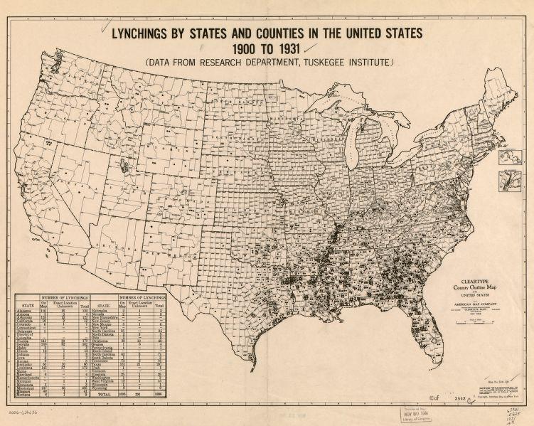
6 Observe Reflect Question What is the title of this What was the most likely purpose for this Why is the map significant or important? How do you know? What is the date of this When was this map published? Are there other dates referenced on this Who is the author or cartographer of this Who produced this What area of the world does this map What kinds of symbols are on this What kinds of labels are on this What colors are on the Is there a legend on the What do you know about this time period? What do any other dates on this map Does this map illustrate or describe spatial patterns (movement, connections, etc.)? Describe the spatial patterns illustrated on this map (movement, connections, ecosystems, etc). What was the motivation of the organization or person making the Have you ever seen a map similar to this one? What does the map show (physical characteristics, human patterns)? What is the bias or point of view of this What seems to be missing from the What is the significance of the date of the How does this map connect to other time periods and the time period under study? How could you use this map to understand the present? How does this map illustrate human, physical, economic, societal, cultural, and political conditions for the time when the map was made? What sources may have been used to make this Do you see any bias / perspective in this How does this map connect to other primary, secondary, or tertiary resources? About what does this map leave you curious?
7
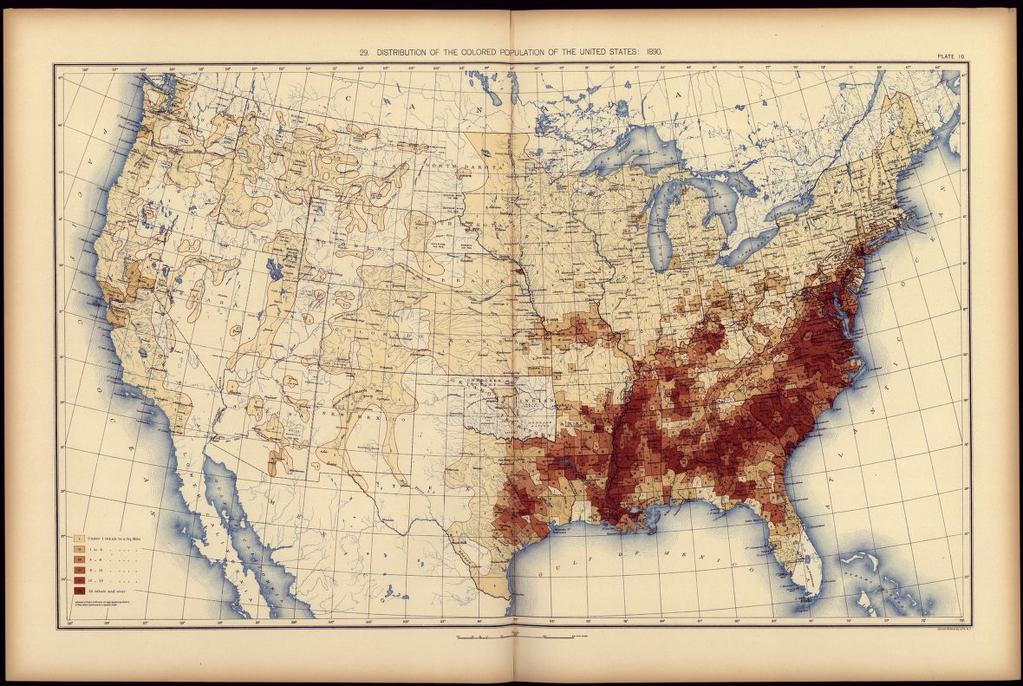
8 Observe Reflect Question What is the title of this What was the most likely purpose for this Why is the map significant or important? How do you know? What is the date of this When was this map published? Are there other dates referenced on this Who is the author or cartographer of this Who produced this What area of the world does this map What kinds of symbols are on this What kinds of labels are on this What colors are on the Is there a legend on the What do you know about this time period? What do any other dates on this map Does this map illustrate or describe spatial patterns (movement, connections, etc.)? Describe the spatial patterns illustrated on this map (movement, connections, ecosystems, etc). What was the motivation of the organization or person making the Have you ever seen a map similar to this one? What does the map show (physical characteristics, human patterns)? What is the bias or point of view of this What seems to be missing from the What is the significance of the date of the How does this map connect to other time periods and the time period under study? How could you use this map to understand the present? How does this map illustrate human, physical, economic, societal, cultural, and political conditions for the time when the map was made? What sources may have been used to make this Do you see any bias / perspective in this How does this map connect to other primary, secondary, or tertiary resources? About what does this map leave you curious?
9
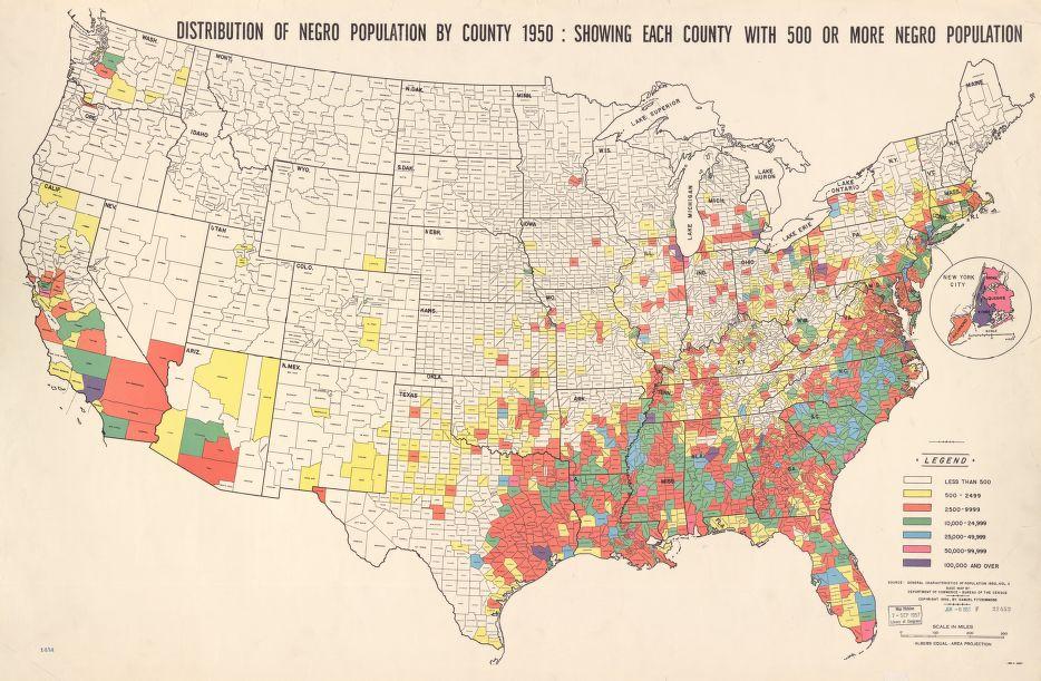
10 Observe Reflect Question What is the title of this What was the most likely purpose for this Why is the map significant or important? How do you know? What is the date of this When was this map published? Are there other dates referenced on this Who is the author or cartographer of this Who produced this What area of the world does this map What kinds of symbols are on this What kinds of labels are on this What colors are on the Is there a legend on the What do you know about this time period? What do any other dates on this map Does this map illustrate or describe spatial patterns (movement, connections, etc.)? Describe the spatial patterns illustrated on this map (movement, connections, ecosystems, etc). What was the motivation of the organization or person making the Have you ever seen a map similar to this one? What does the map show (physical characteristics, human patterns)? What is the bias or point of view of this What seems to be missing from the What is the significance of the date of the How does this map connect to other time periods and the time period under study? How could you use this map to understand the present? How does this map illustrate human, physical, economic, societal, cultural, and political conditions for the time when the map was made? What sources may have been used to make this Do you see any bias / perspective in this How does this map connect to other primary, secondary, or tertiary resources? About what does this map leave you curious?
Revive, Contemplate, and Integrate Lesson Plan. Your Name: Amanda Pellerin, Amanda Kodeck, and Pat Cruz Grade: 7
 Revive, Contemplate, and Integrate Lesson Plan Your Name: Amanda Pellerin, Amanda Kodeck, and Pat Cruz Grade: 7 Unit of Study: Social Studies/ Visual Arts Lesson Title: Modern Day Maps Goal/Purpose: Students
The Physical Geographical Change of the Great Plains during the Dust Bowl (1930 s)
") The Physical Geographical Change of the Great Plains during the Dust Bowl (1930 s) Overview: This lesson shows how the Dust Bowl climate changed the physical geography of the Great Plains and forced the
The Physical Geographical Change of the Great Plains during the Dust Bowl (1930 s) Overview: This lesson shows how the Dust Bowl climate changed the physical geography of the Great Plains and forced the
Grade 6 Social Studies
 Unit Title: Africa : Movement Location Place Human Region : Subject/Course: 6 th Grade Social Studies Essential Questions: peoples, cultures and ideas of the world? How is a location identified using map
Your web browser (Safari 7) is out of date. For more security, comfort and. the best experience on this site: Update your browser Ignore
 is out of date. For more security, comfort and. the best experience on this site: Update your browser Ignore") Your web browser (Safari 7) is out of date. For more security, comfort and lesson the best experience on this site: Update your browser Ignore Political Borders Why are the borders of countries located
Your web browser (Safari 7) is out of date. For more security, comfort and lesson the best experience on this site: Update your browser Ignore Political Borders Why are the borders of countries located
Mapping Project. Name: Theme:
 Mapping Project Name: Theme: Your Task: You will use the information from several thematic maps to create a map of your own using Google Maps. Your map will have a clear theme, and will attempt to answer
Learning Target : Describe the purposes and uses of different types of maps.
 Learning Target : Describe the purposes and uses of different types of maps. Directions: 1. Below, place a where you think you are located. 2. In which continent are you located? 3. In which country are
INDIANA ACADEMIC STANDARDS FOR SOCIAL STUDIES, WORLD GEOGRAPHY. PAGE(S) WHERE TAUGHT (If submission is not a book, cite appropriate location(s))
 WHERE TAUGHT (If submission is not a book, cite appropriate location(s))") Prentice Hall: The Cultural Landscape, An Introduction to Human Geography 2002 Indiana Academic Standards for Social Studies, World Geography (Grades 9-12) STANDARD 1: THE WORLD IN SPATIAL TERMS Students
Prentice Hall: The Cultural Landscape, An Introduction to Human Geography 2002 Indiana Academic Standards for Social Studies, World Geography (Grades 9-12) STANDARD 1: THE WORLD IN SPATIAL TERMS Students
Different types of maps and how to read them.
 Different types of maps and how to read them. A map is a picture or representation of the Earth's surface, showing how things are related to each other by distance, direction, and size. Maps have been
Nature s Art Village
 Nature s Art Village Educational Field Trip Programs Guide To: College, Career & Civic Life C3 Framework For Social Studies State Standards Grades 3 through 5 All That Glitters Children journey back in
STUDY GUIDE. Exploring Geography. Chapter 1, Section 1. Terms to Know DRAWING FROM EXPERIENCE ORGANIZING YOUR THOUGHTS
 For use with textbook pages 19 22. Exploring Geography Terms to Know location A specific place on the earth (page 20) absolute location The exact spot at which a place is found on the globe (page 20) hemisphere
The Arctic Ocean. Grade Level: This lesson is appropriate for students in Grades K-5. Time Required: Two class periods for this lesson
 The Arctic Ocean Lesson Overview: This lesson will introduce students to the Eastern Arctic Region and the benefits of the Arctic Ocean to the people who live in the Far North. This lesson can be modified
LOUISIANA STUDENT STANDARDS FOR SOCIAL STUDIES THAT CORRELATE WITH A FIELD TRIP TO DESTREHAN PLANTATION KINDERGARTEN
 LOUISIANA STUDENT STANDARDS FOR SOCIAL STUDIES THAT CORRELATE WITH A FIELD TRIP TO DESTREHAN PLANTATION KINDERGARTEN Standard 2 Historical Thinking Skills Students distinguish between events, people, and
2275 Speedway, Mail Code C9000 Austin, TX (512) Weather and Climate
 Weather and Climate") Lesson Plan for Grades: Middle School Length of Lesson: 90 minutes Authored by: UT Environmental Science Institute Date created: 05/10/2017 Subject area/course: Mathematics Materials: Fun size bags of
Lesson Plan for Grades: Middle School Length of Lesson: 90 minutes Authored by: UT Environmental Science Institute Date created: 05/10/2017 Subject area/course: Mathematics Materials: Fun size bags of
TEMPLATE FOR CMaP PROJECT
 TEMPLATE FOR CMaP PROJECT Project Title: Native Utah Plants Created by: Anna Davis Class: Box Elder 2008 Project Description Community Issue or Problem Selected -How project evolved? Community Partner(s)
Level 2 Geography, 2014
 91240 912400 2SUPERVISOR S Level 2 Geography, 2014 91240 Demonstrate geographic understanding of a large natural environment 2.00 pm Monday 10 November 2014 Credits: Four Achievement Achievement with Merit
CHAPTER ONE. Uncovering the Past
 CHAPTER ONE Uncovering the Past STUDYING HISTORY What is history? Why do we study it? Why is archaeology important to the study of history? Historian: people who study and write about the human past Archaeologist:
Geographical knowledge and understanding scope and sequence: Foundation to Year 10
 Geographical knowledge and understanding scope and sequence: Foundation to Year 10 Foundation Year 1 Year 2 Year 3 Year 4 Year 5 Year 6 Year level focus People live in places Places have distinctive features
World Geography. WG.1.1 Explain Earth s grid system and be able to locate places using degrees of latitude and longitude.
 Standard 1: The World in Spatial Terms Students will use maps, globes, atlases, and grid-referenced technologies, such as remote sensing, Geographic Information Systems (GIS), and Global Positioning Systems
1. Origins of Geography
 II. ORIGINS AND BRANCHES OF GEOGRAPHY My Notes A. Origins of Geography Unit One 6 Before carefully examining the tools of the geographer, it would be useful to examine the origins and roots of this ancient
Geology Brochures Grade : Sixth An integrated lesson plan covering 5 sessions of approximately 1 hour each.
 Geology Brochures Grade : Sixth An integrated lesson plan covering 5 sessions of approximately 1 hour each. Lesson-Planning Approach Some learners perceive their world as a whole, where all things are
SOCIAL STUDIES GRADE 6. I Can Checklist REGIONS AND PEOPLE OF THE EASTERN HEMISPHERE. Office of Teaching and Learning Curriculum Division
 SOCIAL STUDIES REGIONS AND PEOPLE OF THE EASTERN HEMISPHERE GRADE 6 I Can Checklist 2018-2019 Aligned with Ohio s Learning Standards for Social Studies Office of Teaching and Learning Curriculum Division
Grade 6 Social Studies
 Grade 6 Social Studies Social Studies Grade(s) 6th Course Overview This course focuses on the five Wisconsin Model Academic standards for Social Studies: Geography, History, Political Science and Citizenship,
Expanding Canada s Rail Network to Meet the Challenges of the Future
 Expanding Canada s Rail Network to Meet the Challenges of the Future Lesson Overview Rail may become a more popular mode of transportation in the future due to increased population, higher energy costs,
Mapping Data 1: Constructing a Choropleth Map
 Mapping Data 1: Constructing a Choropleth Map OVERVIEW & OBJECTIVES Students will become acquainted with mapping data and understanding the importance of recognizing patterns by constructing a choropleth
How Irrigation Affected the Geography of Northeast Oregon
 Delia Wallis How Irrigation Affected the Geography of Northeast Oregon Grade Levels: 4 (with ability to move up or down) Time: two x 45-minute sessions Overview: Students are going to study topographical
EVALUATION AND APPROVAL OF ATLASES
 EVALUATION AND APPROVAL OF ATLASES Elementary and Secondary Education Frame of Reference Ministère de l Éducation, du Loisir et du Sport Direction des ressources didactiques Bureau d approbation du matériel
Geography. Programme of study for key stage 3 and attainment target (This is an extract from The National Curriculum 2007)
") Geography Programme of study for key stage 3 and attainment target (This is an extract from The National Curriculum 2007) Crown copyright 2007 Qualifications and Curriculum Authority 2007 Curriculum aims
Geography Programme of study for key stage 3 and attainment target (This is an extract from The National Curriculum 2007) Crown copyright 2007 Qualifications and Curriculum Authority 2007 Curriculum aims
History EC LE UE MS. Knows the names and order of the Seasons of the Year and science behind it
 History EC LE UE MS Time and Timelines : awareness of how the universe and life came to be and his/her place on the continuum. The child discovers interests, makes connections and draws inferences about
LANGUAGE ARTS STANDARDS
 LANGUAGE ARTS STANDARDS STANDARD 1: READING Students learn and effectively apply a variety of reading strategies for comprehending, interpreting and evaluating a wide range of texts including fiction,
5 Themes of Geography Review Video Notes What is Geography?
 Name PG # 5 Themes of Geography Review Video Notes What is Geography? The study of, their, and their Main Idea or Topic Continents Notes about Main Idea or Topic There are 7 Continents or in the world:
Prentice Hall World Studies: Latin America 2005 Correlated to: Missouri Social Studies Grade Level Expectations (Grade 7)
") Principles of Constitutional Democracy 1. Knowledge of the principles expressed in documents shaping constitutional democracy in the United States A. (1) Principles expressed in documents shaping constitutional
Principles of Constitutional Democracy 1. Knowledge of the principles expressed in documents shaping constitutional democracy in the United States A. (1) Principles expressed in documents shaping constitutional
Fifth Grade Social Studies Major Instructional Goals
 Fifth Grade Social Studies Major Instructional Goals We exist for the academic excellence of all students. December 2007 1 Rationale The purpose of the social studies program is to prepare young people
Mission Geography and Missouri Show-Me Standards Connecting Mission Geography to State Standards
 Module 1: Volcanoes local hazard, global issue Mission Geography and Missouri Show-Me Standards Connecting Mission Geography to State Standards Grades 5-8 Inv Geography for Life State Standard(s) Connection
Warm up: (8 min) Use the Map, On the Prom (Color) Paper (Blk/White) and answer the questions on your paper
 Use the Map, On the Prom (Color) Paper (Blk/White) and answer the questions on your paper") Warm up: (8 min) Use the Map, On the Prom (Color) Paper (Blk/White) and answer the questions on your paper TX History: Mapping and Geography of Texas: We will discuss some slides and write notes on others
Warm up: (8 min) Use the Map, On the Prom (Color) Paper (Blk/White) and answer the questions on your paper TX History: Mapping and Geography of Texas: We will discuss some slides and write notes on others
Your web browser (Safari 7) is out of date. For more security, comfort and. the best experience on this site: Update your browser Ignore
 is out of date. For more security, comfort and. the best experience on this site: Update your browser Ignore") Your web browser (Safari 7) is out of date. For more security, comfort and Activitydevelop the best experience on this site: Update your browser Ignore Places in the Park Why do we use symbols? Overview
Your web browser (Safari 7) is out of date. For more security, comfort and Activitydevelop the best experience on this site: Update your browser Ignore Places in the Park Why do we use symbols? Overview
Unit 6 Quadratic Relations of the Form y = ax 2 + bx + c
 Unit 6 Quadratic Relations of the Form y = ax 2 + bx + c Lesson Outline BIG PICTURE Students will: manipulate algebraic expressions, as needed to understand quadratic relations; identify characteristics
Geography: Place & Liveability
 Geography: Place & Liveability Learning Area(s) Geography Year(s) 6, 7 Description AC Geography : Year 6 A diverse and connected world takes a global view of geography and focuses particularly on the concepts
WS/FCS Unit Planning Organizer
 WS/FCS Unit Planning Organizer Subject(s) Social Studies Conceptual Lenses Grade/Course 6 th Geography Unit of Study Unit 1: Human Geography Civilization Unit Title Social Studies 101 Culture Pacing 12
Subject: Geography- Grade Descriptors
 Subject Grade s Developing - Secure This is the Grade at that level = 9 There are no s for 9 Exceptional ly in the top 20% at 8 is awarded 9 8 for 8 securely at 8 showing of AO1, A02 AO3 Excellent knowledge
Washington State K 12 Learning Standards and Guidelines Science Grade: 8 - Adopted: 2014
 Main Criteria: Washington State K 12 Learning Standards and Guidelines Secondary Criteria: Subjects: Science, Social Studies Grade: 8 Correlation Options: Show Correlated Washington State K 12 Learning
Grade 5: Social Studies Practices
 Grade 5: Social Studies Practices A. Gathering and Using Evidence 1. Develop questions to help identify evidence about topics related to the historical events occurring in the Western Hemisphere that can
New York State Learning Standards and Core Curriculum Science Grade: 3 - Adopted: Interdependent Relationships in Ecosystems
 Main Criteria: New York State Learning Standards and Core Curriculum Secondary Criteria: Subjects: Science, Social Studies Grade: 3 Correlation Options: Show Correlated New York State Learning Standards
Geography 101: The Basics
 Geography 101: The Basics What is Geography? Geography is the study of the HUMAN and NON- HUMAN features of the Earth.! Geographers study where things are located why they are located in a specific place.!
Introduction to Geography
 Introduction to Geography What is geography? Geography comes from the Greek word Geographia. Geo means earth and graphia means to describe or chart. Geographers study the earth in relation to space and
A.P. Human Geography
 A.P. Human Geography 2012-2013 Instructor: Chris Vitt Brief Description of Course AP Human Geography is designed to provide students with a learning experience equivalent to that obtained in most college
Alaska Content and Performance Standards Science Grade: 7 - Adopted: Concepts of Life Science (SC1, SC2, SC3)
") Main Criteria: Alaska Content and Performance Standards Secondary Criteria: Subjects: Science, Social Studies Grade: 7 Correlation Options: Show Correlated AK.C1. Alaska Content and Performance Standards
Main Criteria: Alaska Content and Performance Standards Secondary Criteria: Subjects: Science, Social Studies Grade: 7 Correlation Options: Show Correlated AK.C1. Alaska Content and Performance Standards
World Geography Unit Curriculum Document
 Unit Number and Title: Unit 9-Review (including a comparison to North America) Curriculum Concepts: Globalization Culture Democracy Diversity Migration Enduring Understandings (Big Ideas): Time Frame:
Idaho Content Standards Science Grade: 3 - Adopted: 2006
 Main Criteria: Idaho Content Standards Secondary Criteria: Subjects: Science, Social Studies Grade: 3 Correlation Options: Show Correlated Idaho Content Standards Science Grade: 3 - Adopted: 2006 STANDARD
SOCIAL STUDIES GRADE 5. I Can Checklist Office of Teaching and Learning Curriculum Division REGIONS AND PEOPLE OF THE WESTERN HEMISPHERE
 SOCIAL STUDIES REGIONS AND PEOPLE OF THE WESTERN HEMISPHERE GRADE 5 I Can Checklist 2015-2016 Aligned with Ohio s Learning Standards for Social Studies Office of Teaching and Learning Curriculum Division
KS3 Step Descriptors
 Steps Step Descriptor KS3 Step Descriptors 1 Pupils depth of understanding of physical and human geography around their local area and the UK increases, and begins to expand to include the wider world.
WS/FCS Unit Planning Organizer
 WS/FCS Unit Planning Organizer Subject(s) Social Studies Conceptual Lenses Grade/Course 3rd Place Unit of Study Five Themes of Geography Location Unit Title Pacing Geo Explorers 20-22 days Human environment
Chapter 1: The World of Geography
 Chapter 1: The World of Geography Chapter 1: What is Geography? *It is the study of our earth; our home. OR *Anything that can be mapped! *Geography mixes up the physical and human aspects of our world
VOCABULARY SCAVENGER HUNT Five Themes of Geography
 SECTION: VOCABULARY SCAVENGER HUNT Five Themes of Geography Directions: Skim The Five Themes of Geography and define the following words. Geography: Absolute Location: Relative Location: Hemisphere: Equator:
Washington State K 12 Learning Standards and Guidelines Science Grade: 6 - Adopted: 2014
 Main Criteria: Washington State K 12 Learning Standards and Guidelines Secondary Criteria: Subjects: Science, Social Studies Grade: 6 Correlation Options: Show Correlated Washington State K 12 Learning
WS/FCS Unit Planning Organizer
 WS/FCS Unit Planning Organizer Subject(s) Social Studies Conceptual Lenses Grade/Course 6 th Geography Unit of Study Unit 1: Human Geography Civilization Unit Title Social Studies 101 Culture Pacing 12
Delta RV Sixth Grade Social Studies Curriculum Revised 2010
 Delta RV Sixth Grade Social Studies Curriculum Revised 2010 Social Studies: 6 th Grade Principles of Constitutional Democracy Content Standard 1: Knowledge of the principles expressed in documents shaping
Wisconsin Academic Standards Science Grade: 8 - Adopted: 1998
 Main Criteria: Wisconsin Academic Standards Secondary Criteria: Subjects: Science, Social Studies Grade: 8 Correlation Options: Show Correlated Wisconsin Academic Standards Science Grade: 8 - Adopted:
Third Grade Social Studies Indicators Class Summary
 History Standard Construct time lines to demonstrate an understanding of units of time and chronological order. 1. Define and measure time by years, decades and centuries. 2. Place local historical events
Welcome to Geography 107 Introduction to Human Geography
 Welcome to Geography 107 Introduction to Human Geography Dr. Steve Graves California State University, Northridge Are you here today? Get out your clickers and we ll test the system. This is how attendance
First Nations Early Survival and Trade: The Coast Tsimshian
 Lesson Overview First Nations Early Survival and Trade: The Coast Tsimshian First Nations societies were highly advanced in their societal structures and economic systems. This lesson will focus on one
Lesson Quizzes (Individual assessments for each lesson) Social Studies Alive! Our Community and Beyond Lesson 1-6
 Social Studies Alive! Our Community and Beyond Lesson 1-6") 7.1 Basic Geographic Literacy 7.1.3.A-Identigy how basic geographic tools are used to organize and interpret information about people, places and environment. 7.3 Human Characteristics of Places and Regions
7.1 Basic Geographic Literacy 7.1.3.A-Identigy how basic geographic tools are used to organize and interpret information about people, places and environment. 7.3 Human Characteristics of Places and Regions
Many Ways to Name a Place
 Your web browser (Safari 7) is out of date. For more security, comfort and Activityapply the best experience on this site: Update your browser Ignore Many Ways to Name a Place What are the names for the
5 Themes of Geography. Location, Place, Human-Environment Interaction, Movement, Regions
 5 Themes of Geography Location, Place, Human-Environment Interaction, Movement, Regions Location describes where a place lies Absolute Location: a specific description of where a place lies. An address
Paasi, Anssi: Review on Monmonier, M: No dig, no fly, no go: how maps restrict and
 Paasi, Anssi: Review on Monmonier, M: No dig, no fly, no go: how maps restrict and control. Progress in Human Geography 36:2 (2012), pp. 282-289. Mark Monmonier, a distinguished professor of geography
Name: Date: Period: #: Chapter 1: Outline Notes What Does a Historian Do?
 Name: Date: Period: #: Chapter 1: Outline Notes What Does a Historian Do? Lesson 1.1 What is History? I. Why Study History? A. History is the study of the of the past. History considers both the way things
GEOGRAPHY ADVANCED LEVEL
 GEOGRAPHY ADVANCED LEVEL The syllabus is based on the belief that geography makes a valuable contribution to education. This partly derives from the nature of the questions which geographers raise and
This image cannot currently be displayed. Course Catalog. World Geography Glynlyon, Inc.
 This image cannot currently be displayed. Course Catalog World Geography 2016 Glynlyon, Inc. Table of Contents COURSE OVERVIEW... 1 UNIT 1: INTRODUCTION TO GEOGRAPHY... 1 UNIT 2: HUMAN GEOGRAPHY... 1 UNIT
Objective: Construct a paper clock by partitioning a circle into halves and quarters, and tell time to the half hour or quarter hour.
 Lesson 13 Objective: Suggested Lesson Structure Fluency Practice Concept Development Student Debrief Total Time (10 minutes) (40 minutes) (10 minutes) (60 minutes) Fluency Practice (10 minutes) Rename
Unit 2 Lesson 2: The Study of Pre-History
 Unit 2 Lesson 2: The Study of Pre-History Content Expectations 6 and 7 Explain how historians use a variety of sources to explore the past (e.g., artifacts, H1.2.1: Primary and secondary sources including
Harvey Dunn Weather on the Plains. Provided by the South Dakota Art Museum Brookings, South Dakota
 Harvey Dunn Weather on the Plains Provided by the South Dakota Art Museum Brookings, South Dakota South Dakota Artists Curriculum Unit Unit of Study: Harvey Dunn, painter Title of Lesson Plan: Weather
PENNSYLVANIA ACADEMIC STANDARDS
 PENNSYLVANIA ACADEMIC STANDARDS ARTS AND HUMANITIES 9.2 Historical and Cultural Contexts A. Explain historical, cultural and social context of an individual work in the arts B. Relate works in the arts
Sample assessment task. Task details. Content description. Year level 7
 Sample assessment task Year level 7 Learning area Subject Title of task Task details Description of task Type of assessment Purpose of assessment Assessment strategy Evidence to be collected Suggested
Teachers Resources: Set One
 Teachers Resources: Set One This is the first of two teachers resource packs created especially for Our Read 2011. These resources are ideal for inspiring preparatory work to be undertaken with pupils
Team 8-2 Tree Analysis 2011: Buds, Leaves and Climate Change
 Harvard LTER Schoolyard Program ------------------------------------------------------- Teacher Developed Lessons and Documents that integrate Harvard Forest Schoolyard Ecology Themes into curriculum.
What is Geography? *Mixes up the physical and human aspects of our world into one field of study.
 World Geography What is Geography? *It is the study of the earth *Mixes up the physical and human aspects of our world into one field of study. *Shows the relationship between people and the environment.
Acceleration Due to Gravity in my Country
 Acceleration Due to Gravity in my Country http://blossoms.mit.edu/video/lahlouh.html Hello my friends! I believe that you have discussed with your teacher the influences of gravity on our lives, and we
An Introduction to the South Carolina Atlas
 An Introduction to the South Carolina Atlas Daniel E. Stone Pinewood Preparatory School dstone@pinewoodprep.com Overview This lesson is designed to serve as an introduction to the new South Carolina Atlas.
Curriculum Catalog
 2017-2018 Curriculum Catalog 2017 Glynlyon, Inc. Table of Contents WORLD GEOGRAPHY COURSE OVERVIEW...1 UNIT 1: INTRODUCTION TO GEOGRAPHY... 1 UNIT 2: HUMAN GEOGRAPHY... 1 UNIT 3: NORTH AMERICA... 2 UNIT
The Importance of Spatial Literacy
 The Importance of Spatial Literacy Dr. Michael Phoenix GIS Education Consultant Taiwan, 2009 What is Spatial Literacy? Spatial Literacy is the ability to be able to include the spatial dimension in our
Geography for Life. Course Overview
 Geography for Life Description In Geography for Life students will explore the world around them. Using the six essential elements established by the National Geographic Society students will be able to
A Correlation of. Eastern Hemisphere. Ohio s Learning Standards Social Studies: K-12 Grade 6
 A Correlation of Eastern Hemisphere To Grade 6 to,, Grade 6 Introduction This document demonstrates how, Eastern Hemisphere, Ohio Edition, meets : K-12 Social Studies for Grade 6. Correlation page references
Ages of Rock: Geologic Time Scale Lesson by Lacey Moore
 Ages of Rock: Geologic Time Scale Lesson by Lacey Moore Activity Subject: Geologic time scale, creative expression of science concepts Grade Level: 6-8 grades Introduction In this culminating lesson, students
Warmup. geography compass rose culture longitude
 Warmup geography compass rose culture longitude ecosystem latitude 1. study of the special physical and human characteristics of a place or region 2. learned system of shared beliefs, traits, and values
Solar Cells. Steven Thedford Redan High School. Objective. Student will be able to determine the maximum powerpoint and efficiency of a solar. cell.
 Solar Cells Steven Thedford Redan High School Objective cell. Student will be able to determine the maximum powerpoint and efficiency of a solar Background Information Solar cells, photovoltaic cells,
Benchmark A: Describe how the positions and motions of the objects in the universe cause predictable and cyclic events.
 Earth and Space Sciences Students demonstrate an understanding about how Earth systems and processes interact in the geosphere resulting in the habitability of Earth. This includes demonstrating an understanding
Alleghany County Schools Curriculum Guide GRADE/COURSE: World Geography
 GRADE/COURSE: World 2013-14 GRADING PERIOD: 1 st Six Weeks Time Frame Unit/SOLs SOL # Strand Resource Assessment 8 days* The student will use maps, globes, satellite images, photographs, or diagrams to
Dublin City Schools Social Studies Graded Course of Study Grade 5 K-12 Social Studies Vision
 K-12 Social Studies Vision The Dublin City Schools K-12 Social Studies Education will provide many learning opportunities that will help students to: develop thinking as educated citizens who seek to understand
What Is It Like Outside?
 What Is It Like Outside? Focus: Students will describe daily changes in temperature and weather. Specific Curriculum Outcomes Students will be expected to: 1.0 pose questions that lead to exploration and
DRAWING YOUR CONTINENT
 CONTINENT PROJECT PART I On the attached sheet, you will draw your own continent. Use your creativity to create a continent that is uniquely your own. Give the continent a name. When you are finished with
Stillwater Area Schools Curriculum Guide for Elementary Social Studies
 Stillwater Area Schools Curriculum Guide for Elementary Social Studies Grade Four Draft March 21, 2006 Minnesota and the St. Croix Valley I. Historical Skills A. The student will acquire skills of chronological
Wisconsin Academic Standards Science Grade: 5 - Adopted: 1998
 Main Criteria: Wisconsin Academic Standards Secondary Criteria: Subjects: Science, Social Studies Grade: 5 Correlation Options: Show Correlated Wisconsin Academic Standards Science Grade: 5 - Adopted:
Looking at Communities: Comparing Urban and Rural Neighborhoods
 Looking at Communities: Comparing Urban and Rural Neighborhoods OVERVIEW & OBJECTIVES Our urban areas have become so dominant that frequently the children we teach have no connection with and very few
name and locate the world s seven continents and five oceans
 Subject: Geography Activities National Curriculum Objectives One Progression of Skills Name the 7 continents and 5 oceans 3D Jigsaw task to locate continents and seas name and locate the world s seven
Community Cartography (lesson #1)
") LINKING THE NATIONAL GEOGRAPHY STANDARDS TO THE INDIANA SOCIAL STUDIES GUIDELINES GRADES K-12 In an effort to link the National Geography Standards with the Indiana Social Studies Proficiency Guidelines,
LINKING THE NATIONAL GEOGRAPHY STANDARDS TO THE INDIANA SOCIAL STUDIES GUIDELINES GRADES K-12 In an effort to link the National Geography Standards with the Indiana Social Studies Proficiency Guidelines,
Risky world. What is risk? Is our local area a risky place? To understand what is meant by risky places
 Lesson 1: Is our local area a risky place? Place - geographical imaginations, physical and human characteristics of real places. Space spatial patterns and distributionsd Scale making links between scales
Class 4J Autumn Term St. Lucia Adapted from QCA Geography Unit 10 incorporating some elements of Unit 25
 Class 4J Autumn Term 2002 Geography St. Lucia Geography Unit 10 incorporating some elements of Unit 25 ABOUT THE UNIT In this unit children develop ideas about a less economically developed country. When
Data Collection: What Is Sampling?
 Project Planner Data Collection: What Is Sampling? Title: Data Collection: What Is Sampling? Originally Published: 2017 Publishing Company: SAGE Publications, Inc. City: London, United Kingdom ISBN: 9781526408563
Maine Learning Results Science Grade: 4 - Adopted: 2007
 Main Criteria: Maine Learning Results Secondary Criteria: Subjects: Science, Social Studies Grade: 4 Correlation Options: Show Correlated Maine Learning Results Science Grade: 4 - Adopted: 2007 STRAND
AP Human Geography. Course Outline Geography: Its Nature and Perspectives: Weeks 1-4
 AP Human Geography The Course The AP Human Geography course is designed to provide secondary students with the equivalent of one semester of a college introductory human geography class. The purpose of
THINK RICE! GRADE 3 STANDARDS ALIGNMENT
 THINK RICE! GRADE STANDARDS ALIGNMENT National Social Studies Standards Standard I: Culture Eplore and describe similarities and differences in the ways groups, societies, and cultures address similar