copyright 2015 White's Workshop
|
|
|
- Chloe Beasley
- 6 years ago
- Views:
Transcription


1 16 vocabulary cards & pictures 3 printable maps of Florida 2 resource maps of Florida Task cards for political maps Task cards for physical maps Rubrics

2 This packet supports the following Sunshine State Standards.: SS.4.G.1.4 Interpret political and physical maps using map elements SS.4.G.1.1 Identify physical features of Florida. SS.4.G.1.2 Locate and label cultural features on a Florida map. Vocabulary: print, laminate, and cut. Students can match the vocabulary cards to the pictures. Map Tasks: Choose the map you want students to use. Students follow the directions on the task card. If you do not have Florida maps, print the resource maps for students or go to The best part is that you can use these activities in whole group or in independent centers.

3 A political map is a map that shows human made boundaries of countries, states, cities, and towns. A physical map shows the major physical features of an area such as mountains, rivers, and lakes.

4 A cultural map is a map that shows major cities, activities, and tourist attractions. A compass rose is a symbol that shows the directions on a map. The cardinal directions are north, south, east, west. Intermediate directions are northeast, southeast, northwest, northeast.


5 Latitude lines are horizontal lines that cross the globe from east to west. Longitude lines are vertical lines that cross the globe from north to south.

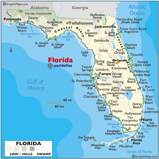
6 Map legend tells what the colors, pictures, and lines on a map mean. Florida is a state located in the southeast U.S.A. It is bordered by the Atlantic Ocean, Gulf of Mexico, Georgia, and Alabama.
7 Political map tasks Political map tasks 1. Create a title for your map. 2. Label the Atlantic Ocean. 3. Label the Gulf of Mexico. 4. Create a compass rose. Include cardinal directions (N,S,E,W) and intermediate directions (NE, SE, SW, NW) 5. Label Tallahassee with a star. 6. Outline the Georgia and Alabama borders in different colors. 7. Label the following cities: a. Miami b. Tampa c. Orlando d. Jacksonville e. Gainesville f. Daytona Beach g. Key West h. St. Augustine i. The city you live in 1. Create a title for your map. 2. Label the Atlantic Ocean. 3. Label the Gulf of Mexico. 4. Create a compass rose. Include cardinal directions (N,S,E,W) and intermediate directions (NE, SE, SW, NW) 5. Label Tallahassee with a star. 6. Outline the Georgia and Alabama borders in different colors. 7. Label the following cities: a. Miami b. Tampa c. Orlando d. Jacksonville e. Gainesville f. Daytona Beach g. Key West h. St. Augustine i. The city you live in
8 Physical map tasks Physical map tasks 1. Create a title for your map. 2. Label the Atlantic Ocean. 3. Label the Gulf of Mexico. 4. Create a compass rose. Include cardinal directions (N,S,E,W) and intermediate directions (NE, SE, SW, NW) 5. Label Tallahassee with a star. 6. Outline the Georgia and Alabama borders in different colors. 7. Label the following physical features: a. St. John s River b. Lake George c. Lake Okeechobee d. The Florida Keys e. The Everglades f. Tampa Bay g. Cape Canaveral 1. Create a title for your map. 2. Label the Atlantic Ocean. 3. Label the Gulf of Mexico. 4. Create a compass rose. Include cardinal directions (N,S,E,W) and intermediate directions (NE, SE, SW, NW) 5. Label Tallahassee with a star. 6. Outline the Georgia and Alabama borders in different colors. 7. Label the following physical features: a. St. John s River b. Lake George c. Lake Okeechobee d. The Florida Keys e. The Everglades f. Tampa Bay g. Cape Canaveral
9 Physical map tasks rubric Name / 5 Create a title for your map. / 5 Label the Atlantic Ocean. / 5 Label the Gulf of Mexico. / 25 Create a compass rose. Include cardinal directions (N,S,E,W) and intermediate directions (NE, SE, SW, NW) / 5 Label Tallahassee with a star. / 5 Outline the Georgia and Alabama borders in different colors. / 50 Label the following physical features: a. St. John s River b. Lake George c. Lake Okeechobee d. The Florida Keys e. The Everglades f. Tampa Bay g. Cape Canaveral Physical map tasks rubric Name / 5 Create a title for your map. / 5 Label the Atlantic Ocean. / 5 Label the Gulf of Mexico. / 25 Create a compass rose. Include cardinal directions (N,S,E,W) and intermediate directions (NE, SE, SW, NW) / 5 Label Tallahassee with a star. / 5 Outline the Georgia and Alabama borders in different colors. / 50 Label the following physical features: a. St. John s River b. Lake George c. Lake Okeechobee d. The Florida Keys e. The Everglades f. Tampa Bay g. Cape Canaveral
10 Political map rubric Political map rubric Name /5 Create a title for your map. /10 Label the Atlantic Ocean. /10 Label the Gulf of Mexico. /10 Create a compass rose. Include cardinal directions (N,S,E,W) and intermediate directions (NE, SE, SW, NW) /5 Label Tallahassee with a star. /5 Outline the Georgia and Alabama borders in different colors. /45 Label the following cities: a. Miami b. Tampa c. Orlando d. Jacksonville e. Gainesville f. Daytona Beach g. Key West h. St. Augustine i. The city you live in /5 spelling and capitals / 5 overall neatness Name /5 Create a title for your map. /10 Label the Atlantic Ocean. /10 Label the Gulf of Mexico. /10 Create a compass rose. Include cardinal directions (N,S,E,W) and intermediate directions (NE, SE, SW, NW) /5 Label Tallahassee with a star. /5 Outline the Georgia and Alabama borders in different colors. /45 Label the following cities: a. Miami b. Tampa c. Orlando d. Jacksonville e. Gainesville f. Daytona Beach g. Key West h. St. Augustine i. The city you live in /5 spelling and capitals / 5 overall neatness
11 Name
12 Name
13 Name
14

15 Toonmaps.com
16
GEOGRAPHY. Map Skills. Mrs. Pere ~ 2013
 GEOGRAPHY Map Skills Mrs. Pere ~ 2013 WHAT IS A GLOBE? A globe is a model of the Earth. North Pole Equator South Pole WHAT IS A MAP? A map is a flat drawing of a place. THE IMPORTANT PARTS OF A MAP 1.
Cardinal and Intermediate Directions:
 Name Period Parent Signature Due Date: (TBA) Geography/Map Skills Study Guide Continents and Oceans of the World: Label the continents (7) and oceans (4) on the lines below the map. 1 11 3 5 4 8 2 9 10
Parts of a Map. Map Skills. The Title. There are 4 main parts of a map: The Title The Compass Rose The Map Key The Scale
 Map Skills Parts of a Map There are 4 main parts of a map: The Title The Compass Rose The Map Key The Scale The Title The title of the map is usually at the top and describes the topic of the map Example:
Map Skills Unit. Note taking unit
 Map Skills Unit Note taking unit Introduction To learn about the Earth, we are going to learn about two geographic tools you can use.globes and maps. Globe A globe is a round model of the planet Earth
DRAWING YOUR CONTINENT
 CONTINENT PROJECT PART I On the attached sheet, you will draw your own continent. Use your creativity to create a continent that is uniquely your own. Give the continent a name. When you are finished with
About places and/or important events Landmarks Maps How the land is, hills or flat or mountain range Connected to maps World Different countries
 What do you think you know about geography? About places and/or important events Landmarks Maps How the land is, hills or flat or mountain range Connected to maps World Different countries What do you
 Name Period Parent Signature Geography/Map Skills Study Guide *For extra practice with these skills, check out Mr. Kath s website: http://rkath.weebly.com/activities--links.html Continents and Oceans of
Know the Lingo LATITUDE LONGITUDE
 Station Alpha SS.6.G.1.1 Use latitude and longitude coordinates to understand the relationship between people and places on the Earth - - - - - - - - - - - - - - - - - - - - - - - - - - - Know the Lingo
Different types of maps and how to read them.
 Different types of maps and how to read them. A map is a picture or representation of the Earth's surface, showing how things are related to each other by distance, direction, and size. Maps have been
Why VOCABULARY? clues
 It s GHSGT Time! Why VOCABULARY? Social Studies is all about MAKING CONNECTIONS Key Terms provide relational clues to guide you in answering test questions! The more WORDS you know, the smarter you are
The World of Geography Pre-Test/Study Guide Chapter 1 Test
 Read each statement or question. On the lines below write the letter of the best answer. 1. Geographers look at the Earth 5. What are the two specific A. by studying cities first. measurements of Earth
Canadian Mapping Big Book
 Canadian Mapping Big Book Grades 4-6 Written by Lynda Golletz Illustrated by S&S Learning Materials About the Author: Lynda Golletz was an elementary school teacher for thirty-three years. She is the author
 Name Period Parent Signature Foundational Skills Study Guide *For extra practice with these skills, check out Mr. Kath s website: http://rkath.weebly.com/activities--links.html Continents and Oceans of
Chapter 1 Study Guide
 Chapter 1 Study Guide Reminders: Vocabulary quiz and test will be on Tuesday, September 6th. Complete study guide and bring completed to school Friday, September 2nd. You are NOT required to print the
Learning Target : Describe the purposes and uses of different types of maps.
 Learning Target : Describe the purposes and uses of different types of maps. Directions: 1. Below, place a where you think you are located. 2. In which continent are you located? 3. In which country are
Maps and Globes. By Kennedy s Korner
 Maps and Globes By Kennedy s Korner Map Key or Symbols Maps use symbols to show places and things on Earth. Symbols are drawings that stand for something real. A map key tells you what each symbol stands
Geographer s Toolkit. Geography of Canada
 Geographer s Toolkit Geography of Canada www.craigmarlatt.com/school Geographer s Toolkit 1. Parts of a Map Map Symbols Mapping Your Location 2. Types of Maps 3. Political Map of Canada 4. Drainage Map
4th Grade US Regional Geography First Nine Weeks
 4th Grade US Regional Geography First Nine Weeks 2014-2015 Identify the choice that best completes the statement or answers the question. 1 The line identified as 0 runs west and east on the globe and
Outline Maps of Canada
 Outline Maps of Canada Grades K-3 About this book: Outline Maps of Canada is an important resource to help introduce and review mapping skills, with an emphasis on Canadian maps. Almost every map included
Simple Solutions Social Studies Level 2. Level 2. Social Studies. Help Pages
 Level 2 Social Studies 147 148 adobe houses with bricks made of clay and straw ancestor a family member who lived before us appoint choose; leaders can appoint others barter trading one thing for another
Teachers Curriculum Institute Map Skills Toolkit 411
 Map kills Toolkit To the Teacher tudents encounter maps every day inside and outside their classes in books and on handheld devices, computers, or television screens. Whether they re navigating cities
CHAPTER 1. Geo Challenges 1A to 1D. & World Map Activity
 CHAPTER 1 Geo Challenges 1A to 1D & World Map Activity SELECT YOUR CHALLENGE World Map Activity Challenge 1A Challenge 1B Challenge 1C Challenge 1D Challenge 1A WS PG. 2 STEP #1 Label the largest continent
Reading a Map in Any Language. Dawn Shattuck NICC; Kathy Sundstedt School not available. Content Area (Req.): Geography Unit (Opt.
: Geography Unit (Opt.") Instructional Sequence/Procedure (Req.): 1. Distribute one copy of Chile map, written in Spanish, to each student group OR direct each group of students to access an online copy of a Chile map. 2. Together,
Instructional Sequence/Procedure (Req.): 1. Distribute one copy of Chile map, written in Spanish, to each student group OR direct each group of students to access an online copy of a Chile map. 2. Together,
Map Skills Lesson 1. Materials: maps, pencils, Lesson 1 Worksheet, strips of paper, grid paper
 Map Skills Lesson 1 Use cardinal directions, map grids, scales, and titles to locate places on a map. Interpret a map using information from its title, compass rose, scale, and legend. Vocabulary: map,
Texas Geography. Understanding the physical and human characteristics of our state
 Texas Geography Understanding the physical and human characteristics of our state To understand Texas you must first learn about its Geography. Geography- The study of the world, its people, and the interaction
United States of America Geography
 United States of America Geography Part I by Sonja E. Schild LearnSmart Publishing Co. Vancouver, BC, Canada Phone: (604) 433-1347 ISBN 0-9694445-3-9 Notice! All rights reserved. Permission to reproduce
Warm up: (8 min) Use the Map, On the Prom (Color) Paper (Blk/White) and answer the questions on your paper
 Use the Map, On the Prom (Color) Paper (Blk/White) and answer the questions on your paper") Warm up: (8 min) Use the Map, On the Prom (Color) Paper (Blk/White) and answer the questions on your paper TX History: Mapping and Geography of Texas: We will discuss some slides and write notes on others
Warm up: (8 min) Use the Map, On the Prom (Color) Paper (Blk/White) and answer the questions on your paper TX History: Mapping and Geography of Texas: We will discuss some slides and write notes on others
Map Skills: Continents and Oceans. Map Skills: Continents and Oceans
 Map Skills: Continents and Oceans Our Earth is made up of continents and oceans. A continent is an enormous mass of land. There are seven continents on our planet. The continents include North America,
Warmup. geography compass rose culture longitude
 Warmup geography compass rose culture longitude ecosystem latitude 1. study of the special physical and human characteristics of a place or region 2. learned system of shared beliefs, traits, and values
2. What does the map scale tell the map reader? a ratio between the actual distance on the ground and the length given to that distance on a map
 AP Human Geography - Damon Name Unit 1 - Intro to Human Geography Hour Map and Globe Skills Review Note: All links in this packet are found on our Wikispace under Map and Globe Skills Review First, read
Student Handout. Write the map s title in the northwest corner of the map. How many picnic areas does the park have? Write the answer near the legend.
 Student Handout 1F Cards Write the map s title in the northwest corner of the map. How many picnic areas does the park have? Write the answer near the legend. 1 2 Draw a compass rose near the west edge
Map directions are broken down into 2 main types; Cardinal Directions and Intermediate Directions SW S
 ELEMENTS OF MAPS COMPASS ROSE AND DIRECTIONS When reading a map it s always important to know your directions. The Compass Rose is the tool to help you do that. Map directions are broken down into 2 main
2 Georgia: Its Heritage and Its Promise
 TERMS region, erosion, fault, elevation, Fall Line, aquifer, marsh, climate, weather, precipitation, drought, tornado, hurricane, wetland, estuary, barrier island, swamp PLACES Appalachian Mountains, Appalachian
Introduction to Geography
 Introduction to Geography ropic of Cancer 3½ N Arctic Circle 90 N Prime Meridian 0 Arctic Ocean Mississippi R. Appalachian Mts. Europe Rocky Mountains N. America Atlantic Gulf of Ocean Mexico Caribbean
Phase 1 Cards. Phase 1. Phase 1. How many picnic areas does the park have? Write the answer near the legend.
 S T U D E N T H A N D O U T F Cards Write the map s title in the northwest corner above the map. How many picnic areas does the park have? Write the answer near the legend. 1 2 Draw a compass rose near
Hurricane Wilma Post Storm Data Acquisition Estimated Peak Wind Analysis and Storm Tide Data. December 27, 2005
 Hurricane Wilma Post Storm Data Acquisition Estimated Peak Wind Analysis and Storm Tide Data December 27, 2005 Hurricane Wilma was the sixth major hurricane of the record-breaking 2005 Atlantic hurricane
Tropical Update. 5 PM EDT Sunday, September 10, 2017 Hurricane Irma, Hurricane Jose, Tropical Wave (60%)
") Tropical Update 5 PM EDT Sunday, September 10, 2017 Hurricane Irma, Hurricane Jose, Tropical Wave (60%) This update is intended for government and emergency response officials, and is provided for informational
Tropical Update 5 PM EDT Sunday, September 10, 2017 Hurricane Irma, Hurricane Jose, Tropical Wave (60%) This update is intended for government and emergency response officials, and is provided for informational
5 Themes of Geography Review Video Notes What is Geography?
 Name PG # 5 Themes of Geography Review Video Notes What is Geography? The study of, their, and their Main Idea or Topic Continents Notes about Main Idea or Topic There are 7 Continents or in the world:
Your web browser (Safari 7) is out of date. For more security, comfort and the best experience on this site: Update your browser Ignore
 is out of date. For more security, comfort and the best experience on this site: Update your browser Ignore") Your web browser (Safari 7) is out of date. For more security, comfort and the best experience on this site: Update your browser Ignore Activityengage MAPPING W O RL D HERITAGE Where are sites of significant
Your web browser (Safari 7) is out of date. For more security, comfort and the best experience on this site: Update your browser Ignore Activityengage MAPPING W O RL D HERITAGE Where are sites of significant
Essential Questions What are the major physical components of the world, and how are they represented on a map? 3.4
 Third Grade Social Studies Unit One Six Weeks GEOGRAPHY Originally compiled by Russellville In order for students to understand that geography influences the development of a region as well as the interactions
Tropical Update 6 AM EDT Friday, October 7, 2016 Hurricane Matthew & Hurricane Nicole
 Tropical Update 6 AM EDT Friday, October 7, 2016 Hurricane Matthew & Hurricane Nicole This update is intended for government and emergency response officials, and is provided for informational and situational
Latitude and Longitude Pre Test
 Name Date Latitude and Longitude Pre Test Multiple Choice Directions: For questions, 1 10 circle the answer that letter that best answers the question. Each question is worth 1 point each. 1. To locate
Grade. Why are maps useful? What do maps tell us?
 ACTIVITY 2.1 Follow That DART Bus! DETAILS TYPE Whole-group TIME 20 minutes plus 20 minutes homework (40 minutes total) PRINTED MATERIALS Handouts (Reading A Map, Follow that DART Bus! map and Follow that
Grade 1 SOCIAL STUDIES Curriculum Map Volusia County Schools Next Generation Sunshine State Standards
 2017-2018 Grade 1 SOCIAL STUDIES Curriculum Map Volusia County Schools Next Generation Sunshine State Standards Next Generation Sunshine State Standards Course Number: 5021030 - Our Community and Beyond:
AP Human Geography World Atlas Project
 AP Human Geography World Atlas Project - 2018 Welcome to Robert E. Lee High School and Advanced Placement Human Geography! You are going to thoroughly enjoy this class. It will be a lot of work, but the
Cardinal And Intermediate Directions Worksheets
 CARDINAL AND INTERMEDIATE DIRECTIONS WORKSHEETS PDF - Are you looking for cardinal and intermediate directions worksheets Books? Now, you will be happy that at this time cardinal and intermediate directions
Map Reading: Grades 4 & 5
 Map Reading: Grades 4 & 5 Grades: 4,5 Team Size: 1-2 competitors Duration: 25 minutes Supervisors: Sriram Garapati, Rebecca Neill-Totsuka Summary Description Students will solve a mystery using different
Social Studies Tools (Maps & Sources) Test Study Guide
 Test Study Guide") Social Studies Tools (Maps & Sources) Test Study Guide Name: ANSWER KEY Date: Period: Directions: Complete this study guide as a way to prepare for your test on our Social Studies Tools unit about maps
Social Studies Tools (Maps & Sources) Test Study Guide Name: ANSWER KEY Date: Period: Directions: Complete this study guide as a way to prepare for your test on our Social Studies Tools unit about maps
World Geography. BY MARK STANGE and REBECCA LARATTA
 BY MARK STANGE and REBECCA LARATTA COPYRIGHT 2002 Mark Twain Media, Inc. ISBN 1-58037-205-8 Printing No. CD-1551 Mark Twain Media, Inc., Publishers Distributed by Carson-Dellosa Publishing Company, Inc.
Wayne E. Sirmon GEO 301 World Regional Geography
 Wayne E. Sirmon GEO 301 Geography 301 Geography 301 MAP: A graphic representation of a portion of the earth s surface dawn to scale, as seen from above. Types of Maps Climate maps give general information
Geography Can Be Cool. Seriously
 Geography Can Be Cool Seriously Why does geography matter? Geography: the study of looking at every aspect of the Earth s systems, such as human economies, societies, cultures, plants, animals, & climate.
Topographic Maps and Profiles
 Name: Date: Period: Earth Science Foundations The Physical Setting: Earth Science CLASS NOTES! Topographic Maps [contour maps] -! Topographic maps show three-dimensional shapes in two dimensions Elevation
Geography 101: The Basics
 Geography 101: The Basics What is Geography? Geography is the study of the HUMAN and NON- HUMAN features of the Earth.! Geographers study where things are located why they are located in a specific place.!
What Is a Globe? Hemispheres. Main Idea Globes and maps provide different ways of showing features of the earth. Terms to Know
 r Main Idea Globes and maps provide different ways of showing features of the earth. Terms to Know hemisphere latitude longitude scale bar scale relief elevation contour line What Is a Globe? A globe is
Reading a Map in Any Language. Kathy Sundstedt and Dawn Brown School not available. Content Area (Req.): Geography Unit (Opt.):
: Geography Unit (Opt.):") Instructional Sequence/Procedure (Req.): 1. Distribute one copy of Bangladesh map, written in Bengali, to each student group. 2. Optional project the same map on the wall from transparency, overhead projector,
Instructional Sequence/Procedure (Req.): 1. Distribute one copy of Bangladesh map, written in Bengali, to each student group. 2. Optional project the same map on the wall from transparency, overhead projector,
Unit 1: Basics of Geography Test Review
 Name Date Period Unit 1: Basics of Geography Test Review Directions: Reading the following sections and complete the questions, charts, and diagrams. Types of Maps Maps that have a particular theme are
MAP SET. BrITAIN S & EXCERPTS. Norman B. Leventhal Map Center Digital Collections leventhalmap.org
 MAP SET BrITAIN S NORTH AMERICAN EMPIRE 1607 1764 Worksheets & EXCERPTS Norman B. Leventhal Map Center Digital Collections leventhalmap.org MAP 1 New england 1675 MAP Inquiry WORKSHEET Circle which of
Tropical Update. 12 PM EDT Friday, October 7, 2016 Hurricane Matthew & Tropical Storm Nicole
 Tropical Update 12 PM EDT Friday, October 7, 2016 Hurricane Matthew & Tropical Storm Nicole This update is intended for government and emergency response officials, and is provided for informational and
Developed in Consultation with Florida Educators
 Developed in Consultation with Florida Educators Table of Contents Next Generation Sunshine State Standards Correlation Chart... 7 Benchmarks Chapter 1 The Practice of Science...................... 11
Understanding Projections
 GEOGRAPHY SKILLS 1 Understanding Projections The earth is a sphere and is best shown as a globe. For books and posters, though, the earth has to be represented as a flat object. To do this, mapmakers create
Unit 9.2 Introduction to Geography
 Unit 9.2 Introduction to Geography Name: Period: This activity has been modified from the Stanford History Education Group from the original found here. 1 What does it mean to think like a geographer?
Name: Political. Map of Canada. Map #1 - Locations to be labelled:
 5. Sketch in the west and east coast of the United States and label the U.S.A. 6. Label St. Pierre et Miquelon (France) 8. Colour the water blue and the United States green. Political maps are designed
Map Skills Test. 1. What do we call a person who makes maps? a. mapographer b. cartographer c. geologist d. archaeologist
 Map Skills Test 1. What do we call a person who makes maps? a. mapographer b. cartographer c. geologist d. archaeologist 2. What is the name of the 0 latitude line? a. Equator b. Arctic Circle c. First
ATheme. Capital Connections. Claudia Crump, Workshop Consultant Indiana University, Southeast
 CAPITAL CONNECTIONS Capital Connections ATheme Claudia Crump, Workshop Consultant Indiana University, Southeast PURPOSE To review basic geographic understandings and skills on location and terminology;
Canadian Mapping. Grades 5-6. Written by Lynda Golletz Illustrated by S&S Learning Materials
 Canadian Mapping Grades 5-6 Written by Lynda Golletz Illustrated by S&S Learning Materials About the Author: Lynda Golletz was an elementary school teacher for thirty-three years. She is the author of
The Compass Rose. Copyright 2006 by Learningworld.ca. All Rights Reserved.
 The Compass Rose The following slides show the steps in creating the compass rose. Following these steps should help you learn the different parts of a compass. The Completed Compass Rose This is what
ORIENTEERING. The challenge is to use the map to decide the best route to complete the course in the quickest time. Orienteering Map. Compass.
 ORIENTEERING Orienteering is similar to a cross-country race but you navigate using a map instead of following a set course. It is an outdoor sport where competitors navigate their own way, you can run,
2011, 1998, 1987 Copyright by Remedia Publications, Inc. All Rights Reserved. Printed in the U.S.A.
 See the world REM 129A A Teaching Resource From 2011, 1998, 1987 Copyright by Remedia Publications, Inc. All Rights Reserved. Printed in the U.S.A. The purchase of this product entitles the individual
MR. JOHNSON S. Geography OHIO COUNTY MIDDLE SCHOOL
 MR. JOHNSON S Geography OHIO COUNTY MIDDLE SCHOOL CHAPTER 1 Geography The science of geography is likely the oldest of all sciences. Geography is the answer to the question that the earliest humans asked,
Map Reading: Grades 2 & 3
 Map Reading: Grades 2 & 3 Grades: 2, 3 Team Size: 1-2 competitors Duration: 25 minutes (5 minute introduction, 20 minutes for questions) Supervisors: Rebecca Neill-Totsuka, Sriram Garapati Summary Description
World Geography Name This Country 4 th Grade
 World Geography Name This Country 4 th Grade West Brooke Curriculum By: Susan Adams & Jennifer Westbrook World Geography Name This Country 4 th Grade West Brooke Curriculum 2014 Written by: Susan Adams
The Circle of Learning
 The Circle of Learning Title: Theme: Subject: Tracking the Storm Weather Predictions Mathematics Overview: Severe weather can have devastating effects on people and the communities in which they live.
Social Studies: The World Post Test Study Guide
 Name: Period: Social Studies: The World Post Test Study Guide Map and Globe Skills: Label the continents and oceans on the lines below the map. 1 11 3 4 5 8 2 9 10 8 6 7 1. 8. 2. 9. 3. 10. 4. 11. 5. 6.
UNIT 1 PACKET: BECOMING A UTAH HISTORIAN
 Name Class Period UTAH HISTORY UNIT 1 PACKET: BECOMING A UTAH HISTORIAN Assignments: History Of Report /10 points History Apps /10 points Utah s Geography Maps /30 points Utah s Geology: Cause & Effect
Unit 1: Geography and Social Studies Skills
 Unit 1: Geography and Social Studies Skills Standard(s) of Learning: WHI.1 The student will improve skills in historical research and geographical analysis by a) Identifying, analyzing, and interpreting
Milford Public Schools Curriculum
 Milford Public Schools Curriculum Department: Social Studies Grade 3 Course Name: Communities Course Description In third grade, students will engage in a yearlong study of communities and specifically
Year 1 name and locate the four countries and capital cities of the United Kingdom and its surrounding seas
 Long Term Objective Organisation for Geography Please note that only statutory requirements should be included in this document; any supplementary guidance and information should be retained by Subject
Maryland Council on Economic Education 1
 How to Make an Apple Pie and See the World by Marjorie Priceman (Dragonfly Books, New York, 1994) ISBN 0-679-88083-6 Literature Annotation: This beautifully illustrated story is about a girl baker who
Lesson Quizzes (Individual assessments for each lesson) Social Studies Alive! Our Community and Beyond Lesson 1-6
 Social Studies Alive! Our Community and Beyond Lesson 1-6") 7.1 Basic Geographic Literacy 7.1.3.A-Identigy how basic geographic tools are used to organize and interpret information about people, places and environment. 7.3 Human Characteristics of Places and Regions
7.1 Basic Geographic Literacy 7.1.3.A-Identigy how basic geographic tools are used to organize and interpret information about people, places and environment. 7.3 Human Characteristics of Places and Regions
Earth Science Unit 1 Test
 Earth Science Unit 1 Test Multiple Choice Identify the choice that best completes the statement or answers the question. 1. The study of meteorology involves the study of a. climate. c. animals. b. outer
World Geography. Teacher s Guide
 World Geography Teacher s Guide WALCH PUBLISHING Table of Contents To the Teacher.......................................................... vi Classroom Management.................................................
Introduction to Cartography Part I
 Introduction to Cartography Part I Introduction to Cartography Maps vs. Globes General Types of Maps Standard Map Features Maps versus Globes Map: a representation of the world, or part of it, in two dimensions
Chapter 1: The World of Geography
 Chapter 1: The World of Geography Chapter 1: What is Geography? *It is the study of our earth; our home. OR *Anything that can be mapped! *Geography mixes up the physical and human aspects of our world
Chapter 3 Models of the Earth. 3.1 Finding Locations on the Earth. 3.1 Objectives
 Chapter 3 Models of the Earth 3.1 Finding Locations on the Earth 3.1 Objectives Explain latitude and longitude. How can latitude and longitude be used to find locations on Earth? How can a magnetic compass
Southwest and Central Asia
 Southwest and Central Asia Preview Making a Mental Map of the Region Look at the outline map of Central and Southwest Asia on the next page. Add a compass rose to the map, showing where north, south, east,
name and locate the world s seven continents and five oceans
 Subject: Geography Activities National Curriculum Objectives One Progression of Skills Name the 7 continents and 5 oceans 3D Jigsaw task to locate continents and seas name and locate the world s seven
Five Themes of Geography. By PresenterMed
 Five Themes of Geography By PresenterMed Geography Geography: the study of the Earth Where are things located? Why are they there? Location Location: where a place is Cardinal Directions: North, South,
Map Makers 2nd Grade
 Map Makers 2nd Grade Students use mapmaking to develop science and social studies concepts and practice map skills while developing a sense of place and a connection to the property. Concepts of landforms,
FIND PLACES ON GLOBES USING LATITUDE
 GLOBES, MAPS & GRAPHS FIND PLACES ON GLOBES USING LATITUDE AND LONGITUDE LINES FIND PLACES ON MAPS USING A GRID SYSTEM NAME SEVERAL TYPES OF MAP PROJECTIONS AND EXPLAIN THEIR BENEFITS AND SHORTCOMINGS
Using Maps. Using Maps. Using Maps. Using Maps
 A is a visual representation, or model, of part or all of the earth. lines are imaginary lines that run east to west around the globe; they are also known as parallels. They show distances in degrees north
5. The topographic map below shows a lake and two rivers.
 Mapping A B1 1. The diagram below shows latitude measurements every 10 degrees and longitude measurements every 15 degrees. What is the latitude and longitude of point X? 5. The topographic map below shows
Montgomery County Schools
 (Daily Learning ) SS-07-4.1.1 use a variety of geographic tools (maps, photographs, charts, graphs, databases) to interpret patterns and locations on Earth s surface in early A.D. 1 LT1: I can identify
Map Skills and Geographic Tools
 Name: Period: Map Skills and Geographic Tools TEKS: 8.9C interpret topographic maps and satellite views to identify land and erosional features and predict how these features may be reshaped by weathering
Activity One. To Scale
 Activity One To Scale The following map of Whale Island has been drawn to scale using the scale 1 inch = 1 mile or 1 cm = 1 km. With a ruler, measure the distance between Dolphin Harbor and Seal Point.
Geography Mile Post 1
 Mile Post 1 Use world maps, atlases and globes to identify the UK and its countries, as well as the countries, continents and oceans studied at this key stage Key Skills IPC learning Goals 1.11 Be able
Pat Taylor Final Project Team Teaching Plan. Lesson Plan 1
 Pat Taylor Final Project Team Teaching Plan Lesson Plan 1 Project Title: Project Description: Features of Michigan Students will illustrate knowledge of Michigan s features by locating and labeling its
21st Century Global Learning
 21st Century Global Learning A focus for 7th grade is on the ever-increasing global interactions in society. This focus includes a study of various societies and regions from every continent. We have already
EQ: Discuss main geographic landforms of the U.S. & Canada and examine varied landforms in relation to their lifestyles.
 EQ: Discuss main geographic landforms of the U.S. & Canada and examine varied landforms in relation to their lifestyles. Places & Terms for Discussion Appalachian Mountains Great Plains Canadian Shield
2017LearnedLessons. Mapping Skills
 Mapping Skills Geography Mapsà Flat representation of the earth Globeà round representation of the earth, truer representation Types of Maps & Uses General Purpose Mapsà show a wide range of information
Table 1. August average temperatures and departures from normal ( F) for selected cities.
 for selected cities.") Climate Summary for Florida August 2016 Prepared by Lydia Stefanova and David Zierden Florida Climate Center, The Florida State University, Tallahassee, Florida Online at: http://climatecenter.fsu.edu/products-services/summaries
Climate Summary for Florida August 2016 Prepared by Lydia Stefanova and David Zierden Florida Climate Center, The Florida State University, Tallahassee, Florida Online at: http://climatecenter.fsu.edu/products-services/summaries