green spaces in metropolitan regions. The case of Randstad, Netherlands
|
|
|
- Megan Wilson
- 6 years ago
- Views:
Transcription

1 A framework of indicator system for evaluation of green spaces in metropolitan regions. The case of Randstad, Netherlands PBL Netherlands Environamental Assessment Agency Alexandra Tisma and Mariana Neto Ruimteconferentie 2011 Roterdam
2 Presentation Structure Introduction Research Context Indicators Research Method Analyses of the results Statiscal indicators Statiscal versus spatial indicators Acessibility Concurrence Environmental Quality Perception and use by inhabitants Conclusions and Recomendations
3 Research Context
4 Why metropolitan green?
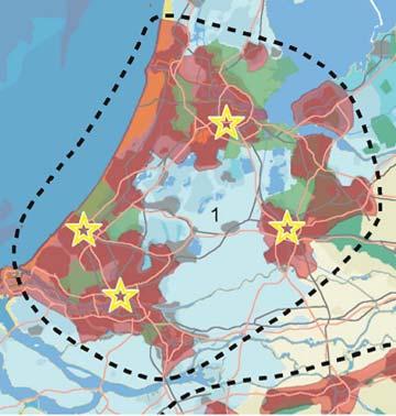
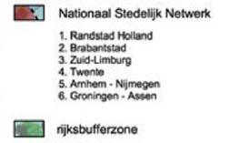
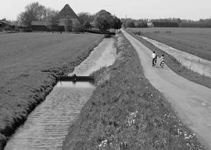
5 Why metropolitan green? Randstad = "network city "metropolitan green space" Metropolitan Urban Local - large green spaces between the cities - urban green areas
6 Research questions A lot of research about sustainability indicators, but very few look at the cross relationships between form, spatial context, and social factors, and at different spatial levels. method that combines indicators for quantity, quality and usability monitoring, evaluation and planning metropolitan green spaces Quantitative versus qualitative indicators? Difference between statistical and spatial indicators? Which selection of indicators will be adequate to support our "research philosophy"? How the results of this research can be used by PBL for policy evaluation and advise? Are indicators useful? When yes and when not? Which criteria can be used to chose adequate indicators from the huge amount of possible indicators?


7 Limitations
8 Indicators
9 Definitions An indicator is something that helps you understand where you are, which way you are going and how far you are from where you want to be. Saramento et al. (2000) Good indicators present information in a clear and usable form at the right time to those who need it (BOYD, 1997). Bell at al. (2000) defined indicator as a measure against which some aspects of policy performance can be assessed. INDICATORS ARE INFORMATION TOOLS
10 Criticism of quantitative norms limited value of quantitative norms and indicators complex nature of green spaces (urban context) partial picture of the function of green areas for both recreation as for other aspects of urban livability such as climate and health improvement. - quality - equipment for leisure and recreation - design amount of green surface


11 Criticism of quantitative norms 75m2 per dwelling in newly built areas 500m = not realistic any more social and demographic composition of the housing areas District City Urban Forest different functional levels on different spatial scale hierarchic system of standards Quarter Neighborhood
12 Quantity vs. Quality Distance, size, type of green space, and the possibility to conduct certain activities, are the most important variables influencing people s preferences. (Ponje and Timmermans, Technological University of Eindhoven, Greenspace Project, 2005). quantitative norms planning practice large scale analyses (national or regional level) local level (in combination with qualitative indicators, experts judgment and users opinion).
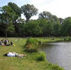
13 Use and Perception People do not use city open space just because it is there and because city planners or designers wish they would J. Jacobs, 1963 Visitors prefer parks containing many qualities. (Berggren-Bärring and Grahn, 1995) Cities have different methods of classification of green spaces and their own way of monitoring, planning, developing and maintaining green areas how to evaluate and compare cities? Preferences of inhabitants (Belevingswaardemonitor PBL, 2009) physical characteristics qualitative research
14 Research Method
15 Research Method Literature Review Spatial analyses (ArcGis) Research philosophy Categories public green spaces Selection of indicators Quantity Quality General indicators Proximity and Accessibility Metropolitan/Urban Urban/local - research time - database Use and perception Barriers and entrances Attractiveness Environmental Application Social aspects Randstad Amsterdam Analyses and discussion Conclusions and recommendations
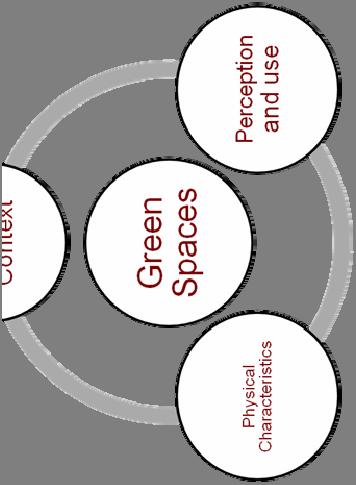

16 Research philosophy Physical Character

17 Definition of the cities borders
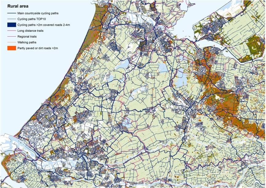
18 Definition of categories of green spaces Large Natural Areas Neighborhood (>1ha) Quarter (1 5ha) District (5 30ha) City (30 300ha) 400m 800m 1600m 3200m m

19 Definition of categories of green spaces
20 Results
21 Statistical indicators % of public green in relation to total urban area
22 Green categories
23 Statiscal indicators m2 public green per dwelling/inhabitant: per city Green Spaces/dwelling (m2) Green Spaces/inhabitant (m2) UTRECHT UTRECHT ROTERDAM DEN HAAG city district quarter neighborhood ROTERDAM DEN HAAG city district quarter neighborhood AMSTERDAM AMSTERDAM 0,00 5,00 10,00 15,00 20,


24 Statiscal vs. spatial indicators % of inhabitants that have access to only 5 green category
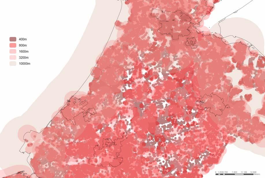
25 Accessibility Coverage
26 Accessibility Concurrence of quarter category

27 Accessibility Concurrence of district category

28 Accessibility Concurrence of city category

29 Accessibility Concurrence on all functional levels
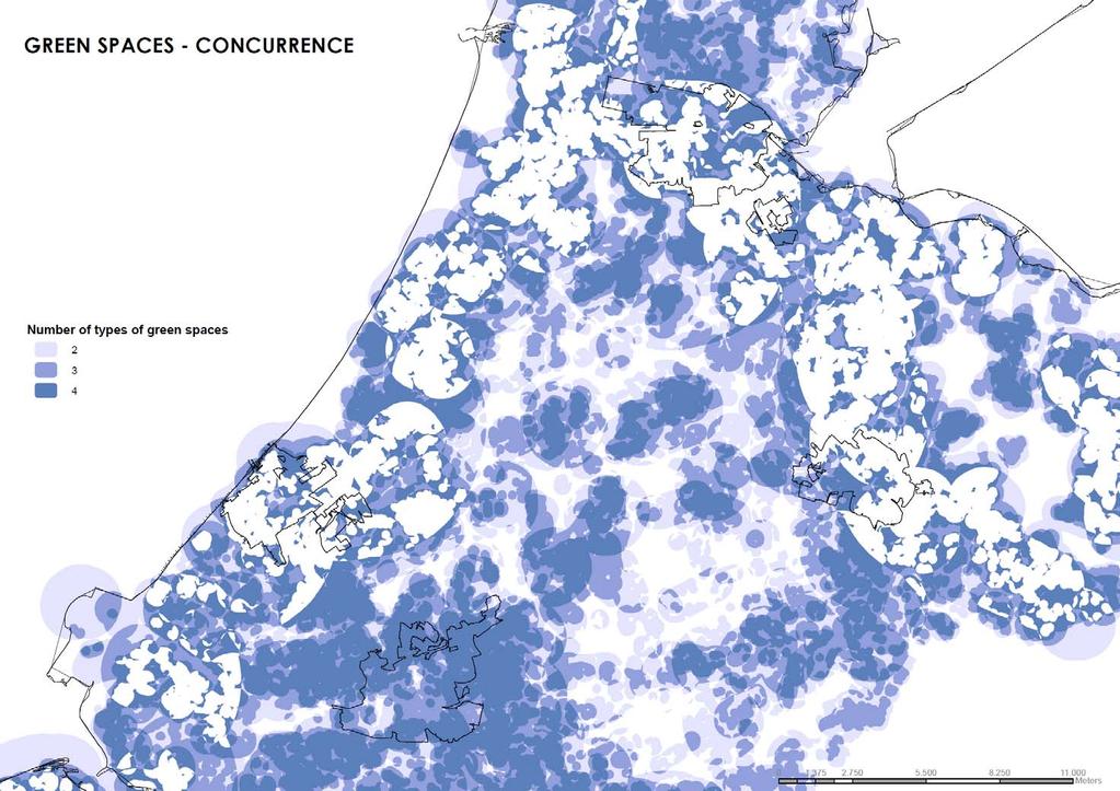
30 Concurrence
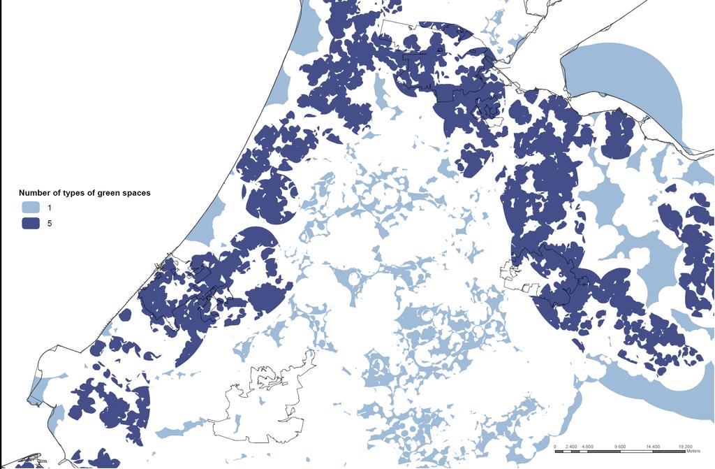
31 Concurrence
32 Concurrence

33 Environmental Quality Air Pollution PM10 (mg/m3)
34 Environmental Quality Green Spaces affected by PM10
35 Environmental Quality Green Spaces affected by Black Smoke
36 Environmental Quality Green Spaces affected by Black Smoke
37 Environmental Quality
38 Environmental Quality

39 Perception and use by inhabitants Local Scale Inhabitants' options from Amsterdam
40 Conclusions
41 On metropolitan level provision of green spaces for recreation is much higher in the fringe formed by the cities then in the Green hart Capacity of Green hart for recreation is low: It is not accessible The network of biking and hiking paths is much less dense that in the dunes and Heuvelrug Generally G4 cities are well covered with a variety of accessible green areas But, the best provided areas are in the periphery of the G4 cities while city centers (most populated areas) have less green spaces and they are also smaller qua size
42 Analyses of accessibility show the most important deficiencies of green spaces for recreation appears on the lowest functional level urban neighborhood and urban quarter. Functional levels sometimes do not correspond with the way people use green spaces (example of Vondelpark and Westerpark) Environmental quality is in the Netherlands not an important precondition for use and perception of quality of green spaces (example of Amsterdamse bos) The method of this research can be applied for: comparison of different cities detection of problematic areas within one city to define priorities, where green is lacking is easily visible to define policy goals on different scale levels
Transport Planning in Large Scale Housing Developments. David Knight
 Transport Planning in Large Scale Housing Developments David Knight Large Scale Housing Developments No longer creating great urban spaces in the UK (Hall 2014) Transport Planning Transport planning processes
Spatial multicriteria analysis for home buyers
 Spatial multicriteria analysis for home buyers Xavier Albacete University of Eastern Finland, Department of Environmental Science, Research Group of Environmental Informatics, Yliopistoranta 1 E, P.O.
Megacity Research Project TP. Ho Chi Minh Adaptation to Global Climate Change in Vietnam: Integrative Urban and Environmental Planning Framework
 1. Organization 2. Global Warming 3. Starting Phase 4. Results, Transdisciplinarity, Low-Rise High Density 5. Risk of Flooding 6. Partners 7. Action Field 1 8. Action Field 2 9. Urban Development Trends
RESIDENTIAL SATISFACTION IN THE CHANGING URBAN FORM IN ADELAIDE: A COMPARATIVE ANALYSIS OF MAWSON LAKES AND CRAIGBURN FARM, SOUTH AUSTRALIA
 RESIDENTIAL SATISFACTION IN THE CHANGING URBAN FORM IN ADELAIDE: A COMPARATIVE ANALYSIS OF MAWSON LAKES AND CRAIGBURN FARM, SOUTH AUSTRALIA by Michael Chadbourne BEPM (Hons) University of Adelaide Thesis
Land Use of the Geographical Information System (GIS) and Mathematical Models in Planning Urban Parks & Green Spaces
 and Mathematical Models in Planning Urban Parks & Green Spaces") Land Use of the Geographical Information System (GIS) and Mathematical Models in Planning Urban Key words: SUMMARY TS 37 Spatial Development Infrastructure Linkages with Urban Planning and Infrastructure
Land Use of the Geographical Information System (GIS) and Mathematical Models in Planning Urban Key words: SUMMARY TS 37 Spatial Development Infrastructure Linkages with Urban Planning and Infrastructure
Local Area Key Issues Paper No. 13: Southern Hinterland townships growth opportunities
 Draft Sunshine Coast Planning Scheme Review of Submissions Local Area Key Issues Paper No. 13: Southern Hinterland townships growth opportunities Key Issue: Growth opportunities for Southern Hinterland
Distribution Pattern Analysis of Green space in Al-Madinah Using GIS Haifaa Al-Ballaa 1, Alexis Comber 2, Claire Smith 3
 Distribution Pattern Analysis of Green space in Al-Madinah Using GIS Haifaa Al-Ballaa 1, Alexis Comber 2, Claire Smith 3 1 Department of Geography, University of Leicester, Leicester LE1 7RH, UK Tel. (00441162523823)
Knowledge claims in planning documents on land use and transport infrastructure impacts
 Knowledge claims in planning documents on land use and transport infrastructure impacts Presentation at the Final Workshop of the research project "Innovations for sustainable public transport in Nordic
Child Opportunity Index Mapping
 Child Opportunity Index Mapping A partnership project of How to Use and Interpret the Child Opportunity Index Maps How to Use the Child Opportunity Index Maps Getting Started: How to Find and Open a Child
GIS and territorial planning
 icccbe 2010 Nottingham University Press Proceedings of the International Conference on Computing in Civil and Building Engineering W Tizani (Editor) GIS and territorial planning S. Sheina & V. Shumeev
Sustainable City Index SCI-2014
 Sustainable City Index SCI-2014 Summary Since its successful launch in 2006, the Sustainable Society Index (SSI) still remains the only index that shows in quantitative terms the level of sustainability
Tackling urban sprawl: towards a compact model of cities? David Ludlow University of the West of England (UWE) 19 June 2014
 19 June 2014") Tackling urban sprawl: towards a compact model of cities? David Ludlow University of the West of England (UWE) 19 June 2014 Impacts on Natural & Protected Areas why sprawl matters? Sprawl creates environmental,
Tackling urban sprawl: towards a compact model of cities? David Ludlow University of the West of England (UWE) 19 June 2014 Impacts on Natural & Protected Areas why sprawl matters? Sprawl creates environmental,
CHAPTER 4: INVENTORY & LEVEL OF SERVICE ANALYSIS
 CHAPTER 4: INVENTORY & LEVEL OF SERVICE ANALYSIS A. Introduction This section provides an overview and analysis of the parks, recreation, trails, and open space system in Cary, North Carolina. First, the
NEW YORK DEPARTMENT OF SANITATION. Spatial Analysis of Complaints
 NEW YORK DEPARTMENT OF SANITATION Spatial Analysis of Complaints Spatial Information Design Lab Columbia University Graduate School of Architecture, Planning and Preservation November 2007 Title New York
From individual perceptions and statistical data to instruments for land resource management
 From individual s and statistical data to instruments for land Land Ulrike Tappeiner, Innsbruck / Bolzano Status quo versus Stefan Marzelli, München Instruments Status quo versus The two sides of the same
ACCESSIBILITY TO SERVICES IN REGIONS AND CITIES: MEASURES AND POLICIES NOTE FOR THE WPTI WORKSHOP, 18 JUNE 2013
 ACCESSIBILITY TO SERVICES IN REGIONS AND CITIES: MEASURES AND POLICIES NOTE FOR THE WPTI WORKSHOP, 18 JUNE 2013 1. Significant differences in the access to basic and advanced services, such as transport,
Measurement of the Urban-Housing Deficit:
 Measurement of the Urban-Housing Deficit: Strategies, tools and sources of information The International Network for Urban and Regional Statistics Standing Committee of the International Association for
Operational Definitions of Urban, Rural and Urban Agglomeration for Monitoring Human Settlements
 Operational Definitions of Urban, Rural and Urban Agglomeration for Monitoring Human Settlements By Markandey Rai United Nations Human Settlements Programme PO Box-30030 Nairobi, Kenya Abstract The United
New Partners for Smart Growth: Building Safe, Healthy, and Livable Communities Mayor Jay Williams, Youngstown OH
 New Partners for Smart Growth: Building Safe, Healthy, and Livable Communities Mayor Jay Williams, Youngstown OH The City of Youngstown Youngstown State University Urban Strategies Inc. Youngstown needed
Global City Definition
 Regional Training Workshop on Human Settlement Indicators Global City Definition Dennis Mwaniki Global Urban Observatory, Research and Capacity Development Branch, UN-Habitat Bangkok, Thailand Outline
STUDY ON RELATIONSHIP BETWEEN CATCHMENT AND BUILT ENVIRONMENT OF METRO STATIONS IN HONG KONG AND SHENZHEN. Yin Ziyuan
 STUDY ON RELATIONSHIP BETWEEN CATCHMENT AND BUILT ENVIRONMENT OF METRO STATIONS IN HONG KONG AND SHENZHEN Yin Ziyuan DOCTOR OF PHILOSOPHY CITY UNIVERSITY OF HONG KONG JUNE 2014 CITY UNIVERSITY OF HONG
Joint-accessibility Design (JAD) Thomas Straatemeier
 Thomas Straatemeier") Joint-accessibility Design (JAD) Thomas Straatemeier To cite this report: Thomas Straatemeier (2012) Joint-accessibility Design (JAD), in Angela Hull, Cecília Silva and Luca Bertolini (Eds.) Accessibility
Joint-accessibility Design (JAD) Thomas Straatemeier To cite this report: Thomas Straatemeier (2012) Joint-accessibility Design (JAD), in Angela Hull, Cecília Silva and Luca Bertolini (Eds.) Accessibility
Rural Pennsylvania: Where Is It Anyway? A Compendium of the Definitions of Rural and Rationale for Their Use
 Rural Pennsylvania: Where Is It Anyway? A Compendium of the Definitions of Rural and Rationale for Their Use Pennsylvania Office of Rural Health 310 Nursing Sciences Building University Park, PA 16802
Identification of the quality of urban life assessment aspects in residential neighbourhoods in Doha
 The Sustainable City IX, Vol. 1 391 Identification of the quality of urban life assessment aspects in residential neighbourhoods in Doha R. Qawasmeh Department of Architecture and Urban Planning, Qatar
Too Close for Comfort
 Too Close for Comfort Overview South Carolina consists of urban, suburban, and rural communities. Students will utilize maps to label and describe the different land use classifications. Connection to
What do we think of our cities?
 What do we think of our cities? Do we think of cities as beautiful places? Are cities healthy places to live? Do most of the world s people live in cities? Do cities function like other natural systems,
Neighborhood Locations and Amenities
 University of Maryland School of Architecture, Planning and Preservation Fall, 2014 Neighborhood Locations and Amenities Authors: Cole Greene Jacob Johnson Maha Tariq Under the Supervision of: Dr. Chao
Taming the Modeling Monster
 Taming the Modeling Monster Starring: Ellen Greenberg Scott McCarey Jim Charlier Audience Poll, part 1 Elected Officials Board Members Public Staff Consultants Journalists Other Audience Poll, part 2 Modeling
KwaliWijzer: An evaluation framework for spatial interventions
 KwaliWijzer: An evaluation framework for spatial interventions Dr. Ir. Alexandra Tisma Netherlands Institute for Spatial Research http://kwaliwijzer.medialab.nl/ The Netherlands Institute for Spatial Research
Be relevant and effective thinking beyond accuracy and timeliness
 The Fourth Technical Conference on the Management of Meteorological and Hydrological Services in WMO RA II (Asia) Be relevant and effective thinking beyond accuracy and timeliness C. Y. LAM Hong Kong Observatory
Metropolitan Wi-Fi Research Network at the Los Angeles State Historic Park
 Metropolitan Wi-Fi Research Network at the Los Angeles State Historic Park Vidyut Samanta vids@remap.ucla.edu Chase Laurelle Alexandria Knowles chase@remap.ucla.edu Jeff Burke jburke@remap.ucla.edu Fabian
Urban Expansion of the City Kolkata since last 25 years using Remote Sensing
 [ VOLUME 5 I ISSUE 2 I APRIL JUNE 2018] E ISSN 2348 1269, PRINT ISSN 2349-5138 Urban Expansion of the City Kolkata since last 25 years using Remote Sensing Soumita Banerjee Researcher, Faculty Council
Land Accounts - The Canadian Experience
 Land Accounts - The Canadian Experience Development of a Geospatial database to measure the effect of human activity on the environment Who is doing Land Accounts Statistics Canada (national) Component
NATURE AND EXTENT OF PROPOSED DEVELOPMENT. Amount of Development Development Zones Distribution of Density Policies
 NATURE AND EXTENT OF PROPOSED DEVELOPMENT Amount of Development Development Zones Distribution of Density Policies DRAFT POOLBEG PLANNING SCHEME Amount of Development 78 4.1 The rationale for the overall
London Plan Density Research
 London Plan Density Research SHMP Elliot Kemp Senior Strategic Planner London Plan review timetable 2016 2017 2018 2019 2020 autumn Towards SHLAA work SHMA work autumn - Draft London Plan consultation
Developing Spatial Data to Support Statistical Analysis of Education
 Developing Spatial Data to Support Statistical Analysis of Education Doug Geverdt National Center for Education Statistics Education Demographic and Geographic Estimates (EDGE) Program 2016 ESRI User Conference
The Road to Data in Baltimore
 Creating a parcel level database from high resolution imagery By Austin Troy and Weiqi Zhou University of Vermont, Rubenstein School of Natural Resources State and local planning agencies are increasingly
City and SUMP of Ravenna
 City and SUMP of Ravenna Nicola Scanferla Head of Mobility Planning Unit, Municipality of Ravenna nscanferla@comune.ra.it place your logo here 19 April, 2017 1st Steering Committee Meeting, Nicosia, Cyprus
Progress and Land-Use Characteristics of Urban Sprawl in Busan Metropolitan City using Remote sensing and GIS
 Progress and Land-Use Characteristics of Urban Sprawl in Busan Metropolitan City using Remote sensing and GIS Homyung Park, Taekyung Baek, Yongeun Shin, Hungkwan Kim ABSTRACT Satellite image is very usefully
M14/3/GEOGR/SP2/ENG/TZ0/XX/Q GEOGRAPHY STANDARD LEVEL PAPER 2. Monday 19 May 2014 (morning) 1 hour 20 minutes INSTRUCTIONS TO CANDIDATES
 1 hour 20 minutes INSTRUCTIONS TO CANDIDATES") M14/3/GEOGR/SP2/ENG/TZ0/XX/Q 22145203 GEOGRAPHY STANDARD LEVEL PAPER 2 Monday 19 May 2014 (morning) 1 hour 20 minutes INSTRUCTIONS TO CANDIDATES Do not open this examination paper until instructed to do
M14/3/GEOGR/SP2/ENG/TZ0/XX/Q 22145203 GEOGRAPHY STANDARD LEVEL PAPER 2 Monday 19 May 2014 (morning) 1 hour 20 minutes INSTRUCTIONS TO CANDIDATES Do not open this examination paper until instructed to do
Exploring Reciprocal Relationships of Land-Uses in a Historical Mixed-Use Quarter of Istanbul
 Exploring Reciprocal Relationships of Land-Uses in a Historical Mixed-Use Quarter of Istanbul Measuring mixed-use patterns of Cihangir Ahu Sokmenoglu 1, N. Onur Sonmez 2 Istanbul Technical University,
MEETING THE CHALLNAGE OF THE URBAN RURAL DIVIDE MAG. SLAVKA ZUPAN
 MEETING THE CHALLNAGE OF THE URBAN RURAL DIVIDE MAG. SLAVKA ZUPAN Urban millenium (Source: GTZ- Services for Sutainable Urban Development))! Today 3 billion of people lives in towns and cities! Every day
The usefulness of the GIS ^ fuzzy set approach in evaluating the urban residential environment
 Environment and Planning B: Planning and Design 22, volume 29, pages 589 ^ 66 DOI:1.168/b2779 The usefulness of the GIS ^ fuzzy set approach in evaluating the urban residential environment Kyushik Oh,
The ESPON Programme. Goals Main Results Future
 The ESPON Programme Goals Main Results Future Structure 1. Goals Objectives and expectations Participation, organisation and networking Themes addressed in the applied research undertaken in ESPON projects
Council Workshop on Neighbourhoods Thursday, October 4 th, :00 to 4:00 p.m. Burlington Performing Arts Centre
 Council Workshop on Neighbourhoods Thursday, October 4 th, 2012 1:00 to 4:00 p.m. Burlington Performing Arts Centre Agenda Introductions Warm-Up Exercise Presentation Exercise Neighbourhood Planning Break
Economic and Social Urban Indicators: A Spatial Decision Support System for Chicago Area Transportation Planning
 Economic and Social Urban Indicators: A Spatial Decision Support System for Chicago Area Transportation Planning Piyushimita Thakuriah (Vonu), P.S. Sriraj, Paul Metaxatos, Inshu Minocha & Tanushri Swarup
Measuring Perceived Accessibility to Urban Green Space: An Integration of GIS and Participatory Map
 Measuring Perceived Accessibility to Urban Green Space: An Integration of GIS and Participatory Map Fariba Sotoudehnia, Lex Comber 1,2 Department of Geography, University of Leicester, UK ABSTRACT Urban
BROOKINGS May
 Appendix 1. Technical Methodology This study combines detailed data on transit systems, demographics, and employment to determine the accessibility of jobs via transit within and across the country s 100
Transforming Johannesburg Towards a low carbon and inclusive metropolis
 Transforming Johannesburg Towards a low carbon and inclusive metropolis Issues and Opportunities Citywide Quantitative Urban Analysis Serge Salat, Karen Levy, Loeiz Bourdic Wits University, July 2014 Corridors
Instituto Superior Técnico Masters in Civil Engineering. Theme 3: Transport networks and external costs. Transport land-use interaction
 Instituto Superior Técnico Masters in Civil Engineering REGIÕES E REDES () Theme 3: Transport land-use interaction Prof. Filipe Moura 1 OUTLINE Transport networks, external costs and market failures Transport
Committee Meeting November 6, 2018
 Committee Meeting November 6, 2018 Agenda Where we are in the process Land Use Plan Transportation Element Housing & Neighborhoods Elements Next Steps Schedule November 6: Plan Elements December: Plan
The Built Environment, Car Ownership, and Travel Behavior in Seoul
 The Built Environment, Car Ownership, and Travel Behavior in Seoul Sang-Kyu Cho, Ph D. Candidate So-Ra Baek, Master Course Student Seoul National University Abstract Although the idea of integrating land
PRIMA. Planning for Retailing in Metropolitan Areas
 PRIMA Planning for Retailing in Metropolitan Areas Metropolitan Dimension to sustainable retailing futures Metropolitan strategies Retailing in city and town centres will be a primary component of any
INTEGRATION OF GIS AND MULTICRITORIAL HIERARCHICAL ANALYSIS FOR AID IN URBAN PLANNING: CASE STUDY OF KHEMISSET PROVINCE, MOROCCO
 Geography Papers 2017, 63 DOI: http://dx.doi.org/10.6018/geografia/2017/280211 ISSN: 1989-4627 INTEGRATION OF GIS AND MULTICRITORIAL HIERARCHICAL ANALYSIS FOR AID IN URBAN PLANNING: CASE STUDY OF KHEMISSET
University College Ghent, Faculty of Applied Engineering Sciences, Belgium
 USING GIS TO FACE PROBLEMS RELATED TO SPATIAL AND SOCIAL INEQUALITY - CASE STUDY: CAPACITY ISSUES OF PRE- SCHOOLS IN GHENT, BELGIUM FRANSEN Koos, VERRECAS Niels University College Ghent, Faculty of Applied
Vital city lively neighborhood living center
 From the ugliest place to heart of the suburb Vital city lively neighborhood living center Marja Straver - Nevalainen September 12 th, 2012 If you want to see the sun, t th look next to it to NL FI 10x
DM-Group Meeting. Subhodip Biswas 10/16/2014
 DM-Group Meeting Subhodip Biswas 10/16/2014 Papers to be discussed 1. Crowdsourcing Land Use Maps via Twitter Vanessa Frias-Martinez and Enrique Frias-Martinez in KDD 2014 2. Tracking Climate Change Opinions
MAES Pilot: Utrecht is growing greener
 MAES Pilot: Utrecht is growing greener 12 February 2016 Authors: Municipality of Utrecht Alterra Hans Kruse (ecology advisor) Albert de Vries (consultant subsurface & natural capital) Michiel van Eupen
How is public transport performing in Australia
 How is public transport performing in Australia CILTA Moving People Thursday 17 March 2011 Professor Corinne Mulley Institute of Transport and Logistics Studies Outline Measuring performance Australia
European spatial policy and regionalised approaches
 Findings of the ESPON 2006 Programme COMMIN Final Conference 26-27 April 2007 European spatial policy and regionalised approaches by Dr. Kai BöhmeB ! Territory matters Structure of presentation! Territorial
National Land Use Policy and National Integrated Planning Framework for Land Resource Development
 Title National Land Use Policy and National Integrated Planning Framework for Land Resource Development Duration: 32 Weeks Objective: Adoption of appropriate land use planning approaches to: Maintain the
Hennepin GIS. Tree Planting Priority Areas - Analysis Methodology. GIS Services April 2018 GOAL:
 Hennepin GIS GIS Services April 2018 Tree Planting Priority Areas - Analysis Methodology GOAL: To create a GIS data layer that will aid Hennepin County Environment & Energy staff in determining where to
A Framework for the Study of Urban Health. Abdullah Baqui, DrPH, MPH, MBBS Johns Hopkins University
 This work is licensed under a Creative Commons Attribution-NonCommercial-ShareAlike License. Your use of this material constitutes acceptance of that license and the conditions of use of materials on this
Module 3 Indicator Land Consumption Rate to Population Growth Rate
 Regional Training Workshop on Human Settlement Indicators Module 3 Indicator 11.3.1 Land Consumption Rate to Population Growth Rate Dennis Mwaniki Global Urban Observatory, Research and Capacity Development
PLANNING FOR TOD IN SMART CITIES
 PLANNING FOR TOD IN SMART CITIES Making transit a preferred choice, not the only choice! Dr. Yamini J. Singh*, Dr. Johannes Flacke^ and Prof. M.F.A.M. van Maarseveen^ * Founder Director, Planit, The Netherlands
Introduction and Project Overview
 Greater New Orleans Regional Land Use Modeling GIS Techniques in a P olitical C ontext Louisiana Remote Sensing and GIS Workshop Wednesday, April 24, 2013 Working Towards a Shared Regional Vision Introduction
compass.durhamnc.gov Building Community by Illustrating Community Durham s Neighborhood Compass
 Building Community by Illustrating Community Durham s Neighborhood Compass A presentation by John Killeen Rob Cushman Tyler Waring Neighborhood Improvement Services & Technology Solutions City of Durham,
Assessment of Sustainable Land Use within the Town Planning Process Experiences with a Multi Criteria Approach (MCA)
") Assessment of Sustainable Land Use within the Town Planning Process Experiences with a Multi Criteria Approach (MCA) Dipl.-Geogr. Sophie Schetke Dipl.-Ing. Benedikt Frielinghaus, University of Bonn, Germany
Assessment of Sustainable Land Use within the Town Planning Process Experiences with a Multi Criteria Approach (MCA) Dipl.-Geogr. Sophie Schetke Dipl.-Ing. Benedikt Frielinghaus, University of Bonn, Germany
Geographic/Demographic Accessibility of Transport Infrastructure (GDATI)
") Geographic/Demographic Accessibility of Transport Infrastructure (GDATI) Lidia Zakowska, Wieslaw Starowicz, Sabina Pulawska To cite this report: Lidia Zakowska, Wieslaw Starowicz and Sabina Pulawska (2012)
Geographic/Demographic Accessibility of Transport Infrastructure (GDATI) Lidia Zakowska, Wieslaw Starowicz, Sabina Pulawska To cite this report: Lidia Zakowska, Wieslaw Starowicz and Sabina Pulawska (2012)
Summary Description Municipality of Anchorage. Anchorage Coastal Resource Atlas Project
 Summary Description Municipality of Anchorage Anchorage Coastal Resource Atlas Project By: Thede Tobish, MOA Planner; and Charlie Barnwell, MOA GIS Manager Introduction Local governments often struggle
FOURTH URBAN RESEARCH SYMPOSIUM URBAN LAND USE AND LAND MARKETS. WASHINGTON D.C., U.S.A. May 2007
 FOURTH URBAN RESEARCH SYMPOSIUM URBAN LAND USE AND LAND MARKETS WASHINGTON D.C., U.S.A. May 2007 METROPOLITAN MONTEVIDEO: LAND USES AND URBAN LAND MARKET CLUSTER 1 ISABEL VIANA URUGUAY METROPOLITAN MONTEVIDEO
MANAGING TRANSPORTATION & LAND USE INTERACTIONS (PL-58)
") MANAGING TRANSPORTATION & LAND USE INTERACTIONS (PL-58) COURSE OUTLINE DAY ONE 1:30 2:00 p.m. MODULE 1: History and Context Understand history and foundation for transportation and land use planning today
MANAGING TRANSPORTATION & LAND USE INTERACTIONS (PL-58) COURSE OUTLINE DAY ONE 1:30 2:00 p.m. MODULE 1: History and Context Understand history and foundation for transportation and land use planning today
Shaping Your Neighbourhood
 Shaping Your Neighbourhood Building a Core Sustainable Neighbourhood Action Plan Nov. 25 & 26, 2006 Welcome! Peter Russell Planner, Holland Barrs Planning Group Inc. Role in this project: Work with the
Conference on Urban Development Strategies in the Mediterranean Barcelona, March 14-15, 2011
 Analysing Urban Development Strategies: the OECD Approach by Adam Knelman Ostry Counsellor, Regional Development Policy adam.ostry@oecd.org Conference on Urban Development Strategies in the Mediterranean
TOWARDS THE DEVELOPMENT OF A MONITORING SYSTEM FOR PLANNING POLICY Residential Land Uses Case study of Brisbane, Melbourne, Chicago and London
 TOWARDS THE DEVELOPMENT OF A MONITORING SYSTEM FOR PLANNING POLICY Residential Land Uses Case study of Brisbane, Melbourne, Chicago and London Presented to CUPUM 12 July 2017 by Claire Daniel Urban Planning/Data
Intercomparison Exercise of Spatial Representativeness Methods
 Intercomparison Exercise of Spatial Representativeness Methods Kristina Eneroth and Sanna Silvergren SLB-analys Stockholm Health and Environment Administration kristina@slb.nu SLB-analys - our organisation
Geographical knowledge and understanding scope and sequence: Foundation to Year 10
 Geographical knowledge and understanding scope and sequence: Foundation to Year 10 Foundation Year 1 Year 2 Year 3 Year 4 Year 5 Year 6 Year level focus People live in places Places have distinctive features
Uses of The Climate and Climate-related Hazard Information in The Adaptation Strategies for Development and Spatial Planning Assessments
 Uses of The Climate and Climate-related Hazard Information in The Adaptation Strategies for Development and Spatial Planning Assessments Wilmar Salim, ST., M. Reg. Dev., Ph.D. Yogyakarta Monday, March
Study Visit University of Applied Sciences Utrecht Netherlands
 Study Visit University of Applied Sciences Utrecht Netherlands Directorate-General for Territorial Development Lisbon 1 April 2014 1 Agenda Presentation Cadastre Department Surveying / Geodesy Department
BIG IDEAS. Area of Learning: SOCIAL STUDIES Urban Studies Grade 12. Learning Standards. Curricular Competencies
 Area of Learning: SOCIAL STUDIES Urban Studies Grade 12 BIG IDEAS Urbanization is a critical force that shapes both human life and the planet. The historical development of cities has been shaped by geographic,
Al Ain Cultural Heritage Management Strategy 1/102
 AL AIN CULTURAL HERITAGE MANAGEMENT STRATEGY EXECUTIVE SUMMARY The cultural heritage of Al Ain is rich and varied; it consists of tangible and intangible resources and incorporates archaeological sites,
FINAL YEAR PRESENTATION USE OF GEOSPATIAL TECHNOLOGY IN SUITABILITY ANALYSIS FOR NEW SITES OF MULTI-LEVEL CAR PARKING AREAS
 FINAL YEAR PRESENTATION USE OF GEOSPATIAL TECHNOLOGY IN SUITABILITY ANALYSIS FOR NEW SITES OF MULTI-LEVEL CAR PARKING AREAS PRESENTED BY JASPHER OTIENO SUPERVISOR DR.NYIKA Contents Overview Area of study
International Journal of Scientific & Engineering Research, Volume 4, Issue 12, December-2013 ISSN
 29 Assessment of Green Space Requirement and Site Analysis in Colombo, Sri Lanka A Remote Sensing and GIS Approach I.P. Senanayake*1, W.D.D.P. Welivitiya1, P.M. Nadeeka1 ABSTRACT - Green space distribution
Vienna urban development - seestadt aspern as urban future lab
 Vienna urban development - seestadt aspern as urban future lab PERMACULTURE DESIGN COURSE * 2012 * ASPERN SEESTADT 1 Christof Schremmer, ÖIR Austrian Institute for Regional Studies and Spatial Planning
International Guidelines on Access to Basic Services for All
 International Guidelines on Access to Basic Services for All Presentation and initials lessons from implementation Accessibility to services in regions and cities : measures and policies, OECD 18 June
Place Syntax Tool (PST)
") Place Syntax Tool (PST) Alexander Ståhle To cite this report: Alexander Ståhle (2012) Place Syntax Tool (PST), in Angela Hull, Cecília Silva and Luca Bertolini (Eds.) Accessibility Instruments for Planning
Place Syntax Tool (PST) Alexander Ståhle To cite this report: Alexander Ståhle (2012) Place Syntax Tool (PST), in Angela Hull, Cecília Silva and Luca Bertolini (Eds.) Accessibility Instruments for Planning
GIS Geographical Information Systems. GIS Management
 GIS Geographical Information Systems GIS Management Difficulties on establishing a GIS Funding GIS Determining Project Standards Data Gathering Map Development Recruiting GIS Professionals Educating Staff
Territorial Cooperation within the Northern Periphery and the Arctic
 Territorial Cooperation within the Northern Periphery and the Arctic 12 March 2013 / By Silvia Curbelo Betancort North charr project, Landösjön lake, Sweden. Source: North Periphery Programme Today we
D2. Addressing tourism related mobility
 14-15 MAY 2018 NICOSIA, CYPRUS D2. Addressing tourism related mobility FROM SUMP TO SRTMP ALONG DANUBE Prof. Lucia Ilieva CSDCS, Bulgaria Agnes Kurzweil Environmental Agency, Austria, Andreas Friedwagner
9th International Conference on U. 21 th July 2. Systems Group/ Eindhoiven University of Technology, the Netherlands
 9th International Conference on U Cl 21 th July 2 An Urban Model for AnalyzingThermal Effects Dependent on Spatial Parameters Hungchu (Rainbow) Chen, Bauke de Vries, Qi Han Systems Group/ Eindhoiven University
Local Economic Activity Around Rapid Transit Stations
 Local Economic Activity Around Rapid Transit Stations The Case of Chicago s Orange Line Julie Cooper, MPP 2014 Harris School of Public Policy Transport Chicago June 6, 2014 Motivation Impacts of transit
King City URA 6D Concept Plan
 King City URA 6D Concept Plan King City s Evolution Among the fastest growing cities 2000 Census 1,949 2010 Census 3,111 60% increase 2016 Census estimate 3,817 23% increase Average annual rate 4.3% Surpassing
Topic 4: Changing cities
 Topic 4: Changing cities Overview of urban patterns and processes 4.1 Urbanisation is a global process a. Contrasting trends in urbanisation over the last 50 years in different parts of the world (developed,
It is clearly necessary to introduce some of the difficulties of defining rural and
 UNIT 2 CHANGING HUMAN ENVIRONMENTS G2 Theme 2 Investigating Settlement Change in MEDCs 2.1 What are the distinctive features of settlements? It is clearly necessary to introduce some of the difficulties
Title: Attracting and retaining knowledge workers: the strengths and weaknesses of Northern-European cities
 Title: Attracting and retaining knowledge workers: the strengths and weaknesses of Northern-European cities Bart Sleutjes, University of Amsterdam General theme: S Regional economic modeling --------------------------------------------------------------------------------------------------------------------------------------
Density and Walkable Communities
 Density and Walkable Communities Reid Ewing Professor & Chair City and Metropolitan Planning University of Utah ewing@arch.utah.edu Department of City & Metropolitan Planning, University of Utah MRC Research
MOR CO Analysis of future residential and mobility costs for private households in Munich Region
 MOR CO Analysis of future residential and mobility costs for private households in Munich Region The amount of the household budget spent on mobility is rising dramatically. While residential costs can
State initiative following up the 2006 national planning report
 18 ness districts and public institutions, should be integrated with the opportunities for public transport services. State initiative following up the 2006 national planning report The Ministry of the
Proposed Scope of Work Village of Farmingdale Downtown Farmingdale BOA Step 2 BOA Nomination Study / Draft Generic Environmental Impact Statement
 Proposed Scope of Work Village of Farmingdale Downtown Farmingdale BOA Step 2 BOA Nomination Study / Draft Generic Environmental Impact Statement The scope of work that follows incorporates and covers
The UrbanSim Project: Using Urban Simulation to Inform Public Decision-making about Land Use and Transportation Choices
 The UrbanSim Project: Using Urban Simulation to Inform Public Decision-making about Land Use and Transportation Choices Alan Borning Dept of Computer Science & Engineering University of Washington, Seattle