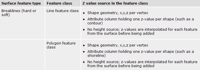
Raster Data Model. Examples of raster data Remotely sensed imagery (BV, DN) DEM (elevation) DRG (color) Raster Database
|
|
|
- Andrea Rose
- 6 years ago
- Views:
Transcription
1 Raster Data Model Why use a raster data model? Raster data representations Cell value Measurement, average, majority, significance Cell-based vs. point-based Raster data components Cells, Pixels, Grid Cell size, spatial resolution Bands Spatial reference Thumbnails Pyramids Examples of raster data Remotely sensed imagery (BV, DN) DEM (elevation) DRG (color) Raster Database ArcGIS Geodatabase Raster Catalog ArcGIS Geodatabase Mosaic Dataset ERDAS APOLLO Essentials SDI (Spatial Data Infrastructure) Features Spatial cataloging (raster footprints) (Dynamic) mosaicking + histogram matching (Dynamic) orthorectification Generating derived layers (slope, hillshade, NDVI, etc) Geoprocessing & image processing Internet capability 1
2 Raster Data Structure Header Dimension and spatial resolution Projection and coordinates Thumbnails Data Types: ascii, binary (1-bit), integer (8-bit), floating-point (4- byte) Single- and multi-band structures (BSQ, BIL, BIP) Quad tree Data compression (lossless, lossy compression) Trailer Color look-up table Statistics (Supplemental) world file (.jpw,.tfw,.sdw,.xml) Raster Data Structure (cont.) Uncompressed/ lossless compression Cell-by-cell encoding Run-length encoding (RLE) Quad Tree Lossy compression JPEG MrSID (Multi-resolution Seamless Image Database) could be a lossless format 2

3 Row, Y Raster Header Information Raster Coordinates Example Columns, Rows = 318, 463 Cellsize X, Y = 30, 30 LL Map Coor. = , Map Coor at Column, Row (= m, n) X = m x 30 Y = (463 n) x 30 Column, X 3

4 Cell-by-Cell RLE Quad tree
5 Geometric Transformation Affine transformation (rotation, translation, scaling) Resampling Nearest neighbor (the nearest cell) Bilinear interpolation (4 nearest cells) Cubic convolution (16 nearest cells) A Testing Interpolator Quality Helmut Dersch (der@fh-furtwangen.de) Technical University Furtwangen Revised June 30,

6 Original Nearest Neighbor Bilinear Interpolation Cubic Convolution Raster Data in ArcGIS GRID.img,.lan,.gis.tiff (.tif) MrSID Geodatabase Raster Band Raster Dataset Raster Catalog Managed/unmanaged 6
 MrSID (Multi-resolution Seamless Image Database) -.")
7 Header Information TIFF(Tag(ged) Image File Format) GeoTIFF,.tfw (TIFF World File) MrSID (Multi-resolution Seamless Image Database) -.sdw (MrSID World File) 7
8 NetCDF (Network Common Data Form) NetCDF (network Common Data Form) is a set of software libraries and machine-independent data formats that support the creation, access, and sharing of arrayoriented scientific data. ArcGIS can create a multidimensional layer from NetCDF. The dimension could be time, altitude, depth, etc. At any given time, only one slice of multidimensional data is visible. Main ArcGIS application: animation What is a layer file (.lyr) in ArcGIS? Layer files reference geographic data stored on disk. You can think of them as a cartographic view of your geographic data. They are separate files on disk and have a.lyr extension. 8
 Generating TIN Selection of significant points from DEM Very Important Points (VIP) Maximum z-tolerance")
9 Triangulated Irregular Network (TIN) Point (x, y, z) Edge Triangles Topology The triangle number The numbers of each adjacent triangle The three nodes defining the triangle The x, y coordinates of each node The surface z value of each node The edge type of each triangle edge (hard or soft) Generating TIN Selection of significant points from DEM Very Important Points (VIP) Maximum z-tolerance Delaunay triangulation Breaklines (soft, hard) P h s d P e G P C a b c 9


10 Contouring Slope Aspect Curvature Convex vs. concave Profile curvature Planiform curvature Terrain Analysis South Surface curvature = profile planiform Z Slope Y Aspect North X ArcGIS 9.3 Terrain Dataset Terrain Dataset LiDAR/SONAR: mass points Contours/ridgelines/streamlines: breaklines GPS 3D elevation points Lake surfaces: polygons 10

 to represent multiple levels of")
11 Terrain Dataset Concepts Terrains use a TIN data structure to represent surfaces Terrains use pyramids (multi-resolution TIN) to represent multiple levels of resolution 11


12 Types of feature class data sources in terrains Mass points Breaklines Clipping polygons Erase polygons Replace polygons Hard and soft qualifiers Mass Points 12
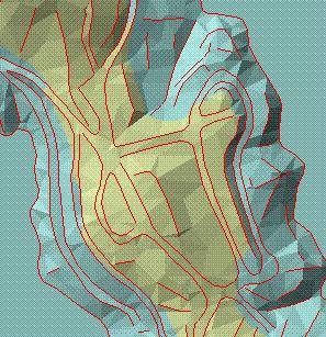
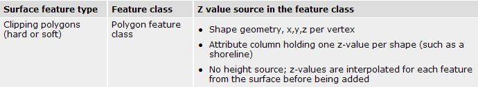
13 Breaklines Soft Hard Clipping Polygons 13


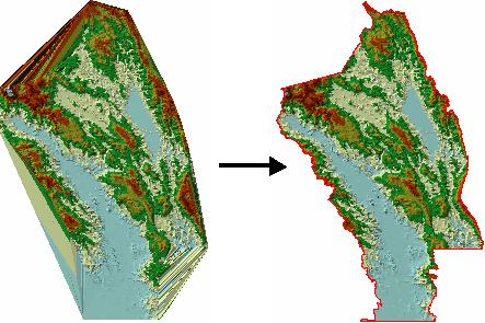
14 Erase Polygons Define holes in a terrain. These are used to represent areas for which you have no data or want no interpolation to occur. They will display as voids, and analysis will consider them to be areas of NoData. Replace Polygons 14


15 Summary Working with Terrain Dataset Terrain 15

16 Special considerations: Rasters, all return LIDAR, TINs, and contours Rasters Terrains should be made from vector-based source measurements rather than rasters. Without the inclusion of ancillary data to make improvements, the conversion of a raster to a terrain could not produce a better surface. All return LIDAR Terrain pyramids are most effective with bare-earth LIDAR. The z-tolerancebased filtering employed by the pyramiding process does not work as well when tree canopy is included. TINs A terrain should be made from the original features used to build a TIN rather than the TIN itself. Contours Contours, as with rasters, are not the best source of data from which to build a terrain. They should be included in the terrain using an SFType of masspoint. Softline is also a possibility but less efficient. 16
ArcGIS 10.0 Imagery. Joseph B. Bowles
 ArcGIS 10.0 Imagery Joseph B. Bowles Presentation Overview Imagery and raster data What is a mosaic dataset Use of mosaic datasets Build a mosaic dataset Migrate to mosaic datasets Q&A Characteristics
Applied Cartography and Introduction to GIS GEOG 2017 EL. Lecture-2 Chapters 3 and 4
 Applied Cartography and Introduction to GIS GEOG 2017 EL Lecture-2 Chapters 3 and 4 Vector Data Modeling To prepare spatial data for computer processing: Use x,y coordinates to represent spatial features
Lecture 6 - Raster Data Model & GIS File Organization
 Lecture 6 - Raster Data Model & GIS File Organization I. Overview of Raster Data Model Raster data models define objects in a fixed manner see Figure 1. Each grid cell has fixed size (resolution). The
Digital Elevation Models (DEM)
") Digital Elevation Models (DEM) Digital representation of the terrain surface enable 2.5 / 3D views Rule #1: they are models, not reality Rule #2: they always include some errors (subject to scale and data
Digital Elevation Models (DEM) Digital representation of the terrain surface enable 2.5 / 3D views Rule #1: they are models, not reality Rule #2: they always include some errors (subject to scale and data
Geography 38/42:376 GIS II. Topic 1: Spatial Data Representation and an Introduction to Geodatabases. The Nature of Geographic Data
 Geography 38/42:376 GIS II Topic 1: Spatial Data Representation and an Introduction to Geodatabases Chapters 3 & 4: Chang (Chapter 4: DeMers) The Nature of Geographic Data Features or phenomena occur as
ArcGIS Data Models: Raster Data Models. Jason Willison, Simon Woo, Qian Liu (Team Raster, ESRI Software Products)
") ArcGIS Data Models: Raster Data Models Jason Willison, Simon Woo, Qian Liu (Team Raster, ESRI Software Products) Overview of Session Raster Data Model Context Example Raster Data Models Important Raster
ArcGIS Data Models: Raster Data Models Jason Willison, Simon Woo, Qian Liu (Team Raster, ESRI Software Products) Overview of Session Raster Data Model Context Example Raster Data Models Important Raster
Working with Elevation Data Using Mosaic Datasets & Image Services. Peter Becker
 Working with Elevation Data Using Mosaic Datasets & Image Services Peter Becker OUTLINE Uses or Elevation data Requirements ArcGIS 10 capabilities - Mosaic Datasets - ArcGIS Server Best Practices Worklow
Managing Imagery and Raster Data Using Mosaic Datasets
 Esri International User Conference San Diego, California Technical Workshops July 25, 2012 Managing Imagery and Raster Data Using Mosaic Datasets Hong Xu, Prashant Mangtani Presentation Overview Introduction
MERGING (MERGE / MOSAIC) GEOSPATIAL DATA
 GEOSPATIAL DATA") This help guide describes how to merge two or more feature classes (vector) or rasters into one single feature class or raster dataset. The Merge Tool The Merge Tool combines input features from input
This help guide describes how to merge two or more feature classes (vector) or rasters into one single feature class or raster dataset. The Merge Tool The Merge Tool combines input features from input
Introduction INTRODUCTION TO GIS GIS - GIS GIS 1/12/2015. New York Association of Professional Land Surveyors January 22, 2015
 New York Association of Professional Land Surveyors January 22, 2015 INTRODUCTION TO GIS Introduction GIS - GIS GIS 1 2 What is a GIS Geographic of or relating to geography the study of the physical features
Introduction to Geographic Information Systems (GIS): Environmental Science Focus
: Environmental Science Focus") Introduction to Geographic Information Systems (GIS): Environmental Science Focus September 9, 2013 We will begin at 9:10 AM. Login info: Username:!cnrguest Password: gocal_bears Instructor: Domain: CAMPUS
Introduction to Geographic Information Systems (GIS): Environmental Science Focus September 9, 2013 We will begin at 9:10 AM. Login info: Username:!cnrguest Password: gocal_bears Instructor: Domain: CAMPUS
Geoprocessing Tools at ArcGIS 9.2 Desktop
 Geoprocessing Tools at ArcGIS 9.2 Desktop Analysis Tools Analysis Tools \ Extract Clip Analysis Tools \ Extract Select Analysis Tools \ Extract Split Analysis Tools \ Extract Table Select Analysis Tools
Introduction to GIS - 2
 Introduction to GIS - 2 Outline Using GIS Representation of spatial objects in GIS Prof. D. Nagesh Kumar Department of Civil Engineering Indian Institute of Science Bangalore 560 012, India http://www.civil.iisc.ernet.in/~nagesh
WORKING WITH DMTI DIGITAL ELEVATION MODELS (DEM)
") WORKING WITH DMTI DIGITAL ELEVATION MODELS (DEM) Contents (Ctrl-Click to jump to a specific page) Manipulating the DEM Step 1: Finding the DEM Tiles You Need... 2 Step 2: Importing the DEM Tiles into ArcMap...
WORKING WITH DMTI DIGITAL ELEVATION MODELS (DEM) Contents (Ctrl-Click to jump to a specific page) Manipulating the DEM Step 1: Finding the DEM Tiles You Need... 2 Step 2: Importing the DEM Tiles into ArcMap...
EnvSci 360 Computer and Analytical Cartography
 EnvSci 360 Computer and Analytical Cartography Lecture 7 Mapping Images, Surfaces, and 3-D Data Brief Overview of Imagery What is Imagery? A spatial data model that defines space as an array of equally
SPOT DEM Product Description
 SPOT DEM Product Description Version 1.1 - May 1 st, 2004 This edition supersedes previous versions Acronyms DIMAP DTED DXF HRS JPEG, JPG DEM SRTM SVG Tiff - GeoTiff XML Digital Image MAP encapsulation
Overview key concepts and terms (based on the textbook Chang 2006 and the practical manual)
") Introduction Geo-information Science (GRS-10306) Overview key concepts and terms (based on the textbook 2006 and the practical manual) Introduction Chapter 1 Geographic information system (GIS) Geographically
Introduction Geo-information Science (GRS-10306) Overview key concepts and terms (based on the textbook 2006 and the practical manual) Introduction Chapter 1 Geographic information system (GIS) Geographically
Object Based Imagery Exploration with. Outline
 Object Based Imagery Exploration with Dan Craver Portland State University June 11, 2007 Outline Overview Getting Started Processing and Derivatives Object-oriented classification Literature review Demo
FNRM 3131 Introduction to GIS in Natural Resource Management
 FNRM 3131 Introduction to GIS in Natural Resource Management Instructors: Andrew C Jenks 215 Green Hall ajenks@umnedu, @acjenks Paul V Bolstad 301H Green Hall pbolstad@umnedu Course Topics Motivation:
A Temporal Hydrologic Database for Rapidly Changing Landscapes
 A Temporal Hydrologic Database for Rapidly Changing Landscapes Using Mt. St. Helens in Washington as a Pilot Site Adam Mosbrucker Geog 575 BACKGROUND: Client / User U.S. Geological Survey Cascades Volcano
GEO-DATA INPUT AND CONVERSION. Christos G. Karydas,, Dr. Lab of Remote Sensing and GIS Director: Prof. N. Silleos
 Christos G. Karydas,, Dr. xkarydas@agro.auth.gr http://users.auth.gr/xkarydas Lab of Remote Sensing and GIS Director: Prof. N. Silleos School of Agriculture Aristotle University of Thessaloniki, GR 1 0.
SPOT DEM Precision Product description
 SPOT DEM Precision Product description Version1.0 - April 1st, 2006 This edition supersedes previous versions Acronyms DIMAP DTED DXF HRS JPEG, JPG Mb DTM DEM SRTM SVG TIFF - GeoTIFF XML Digital Image
Display data in a map-like format so that geographic patterns and interrelationships are visible
 Vilmaliz Rodríguez Guzmán M.S. Student, Department of Geology University of Puerto Rico at Mayagüez Remote Sensing and Geographic Information Systems (GIS) Reference: James B. Campbell. Introduction to
Popular Mechanics, 1954
 Introduction to GIS Popular Mechanics, 1954 1986 $2,599 1 MB of RAM 2017, $750, 128 GB memory, 2 GB of RAM Computing power has increased exponentially over the past 30 years, Allowing the existence of
ENGRG Introduction to GIS
 ENGRG 59910 Introduction to GIS Michael Piasecki March 17, 2014 Lecture 08: Terrain Analysis Outline: Terrain Analysis Earth Surface Representation Contour TIN Mass Points Digital Elevation Models Slope
Geog 469 GIS Workshop. Data Analysis
 Geog 469 GIS Workshop Data Analysis Outline 1. What kinds of need-to-know questions can be addressed using GIS data analysis? 2. What is a typology of GIS operations? 3. What kinds of operations are useful
If this is your first experience with LiDAR data you might want to check out the MGISAC s whitepaper on LiDAR here:
 IMPORTANT NOTE! If the LiDAR data products you re looking are not in the maps.wustl.edu / mo_lidar_data directory then it is either not available for public access yet - is in the pipeline to be posted
Geodatabase An Introduction
 2013 Esri International User Conference July 8 12, 2013 San Diego, California Technical Workshop Geodatabase An Introduction David Crawford and Jonathan Murphy Session Path The Geodatabase What is it?
ENGRG Introduction to GIS
 ENGRG 59910 Introduction to GIS Michael Piasecki November 17, 2017 Lecture 11: Terrain Analysis Outline: Terrain Analysis Earth Surface Representation Contour TIN Mass Points Digital Elevation Models Slope
Final Project: Geodatabase of Mule Mountains Area, southeastern Arizona
 R. Aisner 11/24/09 GEO 386G Final Project: Geodatabase of Mule Mountains Area, southeastern Arizona Project goal: Develop a geodatabase with vector and raster data for future data organization and analysis.
Geoinformation in Environmental Modelling
 Geoinformation in Environmental Modelling Spatial analysis and modelling: grid data ENY-C2005 Salla Multimäki 18.1.2017 Topics today About spatial analysis and modelling Various viewpoints for categorizing
Introduction to GIS I
 Introduction to GIS Introduction How to answer geographical questions such as follows: What is the population of a particular city? What are the characteristics of the soils in a particular land parcel?
Watershed Sciences 4930 & 6920 Advanced GIS
 Slides by Wheaton et al. (2009-2014) are licensed under a Creative Commons Attribution-NonCommercial-ShareAlike 3.0 Unported License Watershed Sciences 4930 & 6920 Advanced GIS WEEK TWO Lecture 3 Data
SuperGIS Server 3.3 Functionality Matrix
 Functionality Matrix Apr 2017 Functionality Matrix SuperGIS Server, a comprehensive and server-based GIS, is designed for the organizations to create, manage, integrate and distribute a variety of GIS
Geodatabase An Overview
 Federal GIS Conference February 9 10, 2015 Washington, DC Geodatabase An Overview Ralph Denkenberger - esri Session Path The Geodatabase - What is it? - Why use it? - What types are there? Inside the Geodatabase
An Introduction to Geographic Information System
 An Introduction to Geographic Information System PROF. Dr. Yuji MURAYAMA Khun Kyaw Aung Hein 1 July 21,2010 GIS: A Formal Definition A system for capturing, storing, checking, Integrating, manipulating,
Introduction to the 176A labs and ArcGIS
 Introduction to the 176A labs and ArcGIS Acknowledgement: Slides by David Maidment, U Texas-Austin and Francisco Olivera (TAMU) Purpose of the labs Hands-on experience with one software pakage Introduction
G EOSPAT I A L ERDAS IMAGINE. The world s most widely-used software package for creating information from geospatial data
 G EOSPAT I A L ERDAS IMAGINE The world s most widely-used software package for creating information from geospatial data ERDAS IMAGINE Geographic imaging professionals need to process vast amounts of
These modules are covered with a brief information and practical in ArcGIS Software and open source software also like QGIS, ILWIS.
 Online GIS Training and training modules covered are: 1. ArcGIS, Analysis, Fundamentals and Implementation 2. ArcGIS Web Data Sharing 3. ArcGIS for Desktop 4. ArcGIS for Server These modules are covered
NR402 GIS Applications in Natural Resources
 NR402 GIS Applications in Natural Resources Lesson 1 Introduction to GIS Eva Strand, University of Idaho Map of the Pacific Northwest from http://www.or.blm.gov/gis/ Welcome to NR402 GIS Applications in
Digital Elevation Models (DEM) / DTM
 / DTM") Digital Elevation Models (DEM) / DTM Uses in remote sensing: queries and analysis, 3D visualisation, classification input Fogo Island, Cape Verde Republic ASTER DEM / image Banks Peninsula, Christchurch,
Digital Elevation Models (DEM) / DTM Uses in remote sensing: queries and analysis, 3D visualisation, classification input Fogo Island, Cape Verde Republic ASTER DEM / image Banks Peninsula, Christchurch,
Working with Digital Elevation Models and Spot Heights in ArcMap
 Working with Digital Elevation Models and Spot Heights in ArcMap 10.3.1 1 TABLE OF CONTENTS INTRODUCTION... 3 WORKING WITH SPOT HEIGHTS FROM NRVIS, CITY OF KITCHENER, AND CITY OF TORONTO...4 WORKING WITH
RESEARCH METHODOLOGY
 III. RESEARCH METHODOLOGY 3.1 Time and Location This research has been conducted in period March until October 2010. Location of research is over Sumatra terrain. Figure 3.1 show the area of interest of
Geodatabase Essentials Part One - Intro to the Geodatabase. Jonathan Murphy Colin Zwicker
 Geodatabase Essentials Part One - Intro to the Geodatabase Jonathan Murphy Colin Zwicker Session Path The Geodatabase - What is it? - Why use it? - What types are there? Inside the Geodatabase Advanced
ARCGIS COURSE, ADVANCED LEVEL ONLINE TRAINING
 ARC COURSE, ADVANCED LEVEL ONLINE TRAINING Training Course.com TYC TRAINING OVERVIEW This course will qualify students in Arc Desktop 10.x and in particular in the usage of ArcMap, ArcCatalog and ArcTool
Tutorial 8 Raster Data Analysis
 Objectives Tutorial 8 Raster Data Analysis This tutorial is designed to introduce you to a basic set of raster-based analyses including: 1. Displaying Digital Elevation Model (DEM) 2. Slope calculations
Spatial Analyst. By Sumita Rai
 ArcGIS Extentions Spatial Analyst By Sumita Rai Overview What does GIS do? How does GIS work data models Extension to GIS Spatial Analyst Spatial Analyst Tasks & Tools Surface Analysis Surface Creation
Tutorial: Basic Gridding of ALSM Point Data
 Civil and Coastal Engineering Department Tutorial: Basic Gridding of ALSM Point Data GEM Center Report No. Rep_2005-01-003 M. Starek and K.C. Slatton January 12, 2005 2005, GEM. All rights reserved Point
Tim Loesch Minnesota Department of Natural Resources
 Tim Loesch Minnesota Department of Natural Resources Agenda Status of State Project Where to get data What types of data are available How to download and retrieve information What to do after you download
EEOS 381 -Spatial Databases and GIS Applications
 EEOS 381 -Spatial Databases and GIS Applications Lecture 5 Geodatabases What is a Geodatabase? Geographic Database ESRI-coined term A standard RDBMS that stores and manages geographic data A modern object-relational
Lecture 2. Introduction to GIS Software and Resources
 Lecture 2 Introduction to GIS Software and Resources GIS in Water Resources Spring 2015 Introduction to GIS Software there are others. Proprietary: 1 Introduction to GIS Software and even more. OpenSource:
GIS CONCEPTS ARCGIS METHODS AND. 3 rd Edition, July David M. Theobald, Ph.D. Warner College of Natural Resources Colorado State University
 GIS CONCEPTS AND ARCGIS METHODS 3 rd Edition, July 2007 David M. Theobald, Ph.D. Warner College of Natural Resources Colorado State University Copyright Copyright 2007 by David M. Theobald. All rights
Outcrop suitability analysis of blueschists within the Dry Lakes region of the Condrey Mountain Window, North-central Klamaths, Northern California
 Outcrop suitability analysis of blueschists within the Dry Lakes region of the Condrey Mountain Window, North-central Klamaths, Northern California (1) Introduction: This project proposes to assess the
Working with Digital Elevation Models and Digital Terrain Models in ArcMap 9
 Working with Digital Elevation Models and Digital Terrain Models in ArcMap 9 1 TABLE OF CONTENTS INTRODUCTION...3 WORKING WITH DIGITAL TERRAIN MODEL (DTM) DATA FROM NRVIS, CITY OF KITCHENER, AND CITY OF
Designing GIS Databases to Support Mapping and Map Production Charlie Frye, ESRI Redlands Aileen Buckley, ESRI Redlands
 Designing GIS Databases to Support Mapping and Map Production Charlie Frye, ESRI Redlands Aileen Buckley, ESRI Redlands 1 Designing GIS Databases to Support Mapping and Map Production Charlie Frye, ESRI
Application of high-resolution (10 m) DEM on Flood Disaster in 3D-GIS
 DEM on Flood Disaster in 3D-GIS") Risk Analysis V: Simulation and Hazard Mitigation 263 Application of high-resolution (10 m) DEM on Flood Disaster in 3D-GIS M. Mori Department of Information and Computer Science, Kinki University, Japan
Risk Analysis V: Simulation and Hazard Mitigation 263 Application of high-resolution (10 m) DEM on Flood Disaster in 3D-GIS M. Mori Department of Information and Computer Science, Kinki University, Japan
Spatial Analyst: Multiple Criteria Evaluation Material adapted from FOR 4114 developed by Forestry Associate Professor Steve Prisley
 Spatial Analyst: Multiple Criteria Evaluation Material adapted from FOR 4114 developed by Forestry Associate Professor Steve Prisley Section 1: Data In this exercise we will be working with several types
Working with OGC WCS. Zikang Zhou
 Working with OGC WCS Zikang Zhou zzhou@esri.com Working with OGC WCS Introduction The Open Geospatial Consortium, Inc. (OGC) Web Coverage Service (WCS) provides an open specification for sharing coverages
Digital Elevation Models (DEM) / DTM
 / DTM") Digital Elevation Models (DEM) / DTM Uses in remote sensing: queries and analysis, 3D visualisation, layers in classification Fogo Island, Cape Verde Republic ASTER DEM / image Banks Peninsula, Christchurch,
Digital Elevation Models (DEM) / DTM Uses in remote sensing: queries and analysis, 3D visualisation, layers in classification Fogo Island, Cape Verde Republic ASTER DEM / image Banks Peninsula, Christchurch,
Introduction-Overview. Why use a GIS? What can a GIS do? Spatial (coordinate) data model Relational (tabular) data model
 data model Relational (tabular) data model") Introduction-Overview Why use a GIS? What can a GIS do? How does a GIS work? GIS definitions Spatial (coordinate) data model Relational (tabular) data model intro_gis.ppt 1 Why use a GIS? An extension
Introduction-Overview Why use a GIS? What can a GIS do? How does a GIS work? GIS definitions Spatial (coordinate) data model Relational (tabular) data model intro_gis.ppt 1 Why use a GIS? An extension
Lecture 1 Intro to GIS and GIS Vector and Raster Data Models
 Lecture 1 Intro to GIS and GIS Vector and Raster Data Models Tomislav Sapic GIS Technologist Faculty of Natural Resources Management Lakehead University Object GIS layer Use Hydro Pole utilities utility
Determining the Location of the Simav Fault
 Lindsey German May 3, 2012 Determining the Location of the Simav Fault 1. Introduction and Problem Formulation: The issue I will be focusing on involves interpreting the location of the Simav fault in
Georelational Vector Data Model
 Georelational Vector Data Model Contents Georelational Data Model Representation of Simple Features Topology Non-topological Vector Data Data Models for Composite Features Geo-relational Looking at a paper
UPDATING AND REFINEMENT OF NATIONAL 1: DEM. National Geomatics Center of China, Beijing
 UPDATING AND REFINEMENT OF NATIONAL 1:500000 DEM Jian-jun LIU a, Dong-hua WANG a, Yao-ling SHANG a, Wen-hao ZHAO a Xi KUAI b a National Geomatics Center of China, Beijing 100830 b School of Resources and
Watershed Delineation
 Watershed Delineation Jessica L. Watkins, University of Georgia 2 April 2009 Updated by KC Love February 25, 2011 PURPOSE For this project, I delineated watersheds for the Coweeta synoptic sampling area
Geodatabase An Introduction
 Federal GIS Conference 2014 February 10 11, 2014 Washington DC Geodatabase An Introduction Ralph Denkenberger esri Session Path The Geodatabase - What is it? - Why use it? - What types are there? Inside
ISO Swift Current LiDAR Project 2009 Data Product Specifications. Revision: A
 ISO 19131 Swift Current LiDAR Project 2009 Data Product Specifications Revision: A Data product specifications: Swift Current LiDAR Project 2009 - Table of Contents- 1. Overview... 4 1.1. Informal description...
GIS in Water Resources Midterm Exam Fall 2008 There are 4 questions on this exam. Please do all 4.
 Page 1 of 8 Name: GIS in Water Resources Midterm Exam Fall 2008 There are 4 questions on this exam. Please do all 4. 1. Basic Concepts [20 points] Find the letter with the best answer for each term: 1.
Generation and analysis of Digital Elevation Model (DEM) using Worldview-2 stereo-pair images of Gurgaon district: A geospatial approach
 using Worldview-2 stereo-pair images of Gurgaon district: A geospatial approach") 186 Generation and analysis of Digital Elevation Model (DEM) using Worldview-2 stereo-pair images of Gurgaon district: A geospatial approach Arsad Khan 1, Sultan Singh 2 and Kaptan Singh 2 1 Department
186 Generation and analysis of Digital Elevation Model (DEM) using Worldview-2 stereo-pair images of Gurgaon district: A geospatial approach Arsad Khan 1, Sultan Singh 2 and Kaptan Singh 2 1 Department
Data Structures & Database Queries in GIS
 Data Structures & Database Queries in GIS Objective In this lab we will show you how to use ArcGIS for analysis of digital elevation models (DEM s), in relationship to Rocky Mountain bighorn sheep (Ovis
SATELLITE REMOTE SENSING
 SATELLITE REMOTE SENSING of NATURAL RESOURCES David L. Verbyla LEWIS PUBLISHERS Boca Raton New York London Tokyo Contents CHAPTER 1. SATELLITE IMAGES 1 Raster Image Data 2 Remote Sensing Detectors 2 Analog
Working with OGC WCS Services - WCS in ArcGIS. Zikang Zhou
 Working with OGC WCS Services - WCS in ArcGIS Zikang Zhou zzhou@esri.com OGC WCS introduction The Open Geospatial Consortium, Inc. (OGC) Web Coverage Service (WCS) provides an open specification for sharing
The Geodatabase Working with Spatial Analyst. Calculating Elevation and Slope Values for Forested Roads, Streams, and Stands.
 GIS LAB 7 The Geodatabase Working with Spatial Analyst. Calculating Elevation and Slope Values for Forested Roads, Streams, and Stands. This lab will ask you to work with the Spatial Analyst extension.
Digital Elevation Model
 Digital Elevation Model DEM, DSM, DTM? DSM: digital surface model. Height of the earth s surface, including houses, trees, boulders...etc. DTM: digital terrain model. Bare-earth earth surface model. Filtered
Exercise 6: Working with Raster Data in ArcGIS 9.3
 Exercise 6: Working with Raster Data in ArcGIS 9.3 Why Spatial Analyst? Grid query Grid algebra Grid statistics Summary by zone Proximity mapping Reclassification Histograms Surface analysis Slope, aspect,
A Detailed Examination of DTM Creation Methods and Sources. Study Area Overview
 A Detailed Examination of DTM Creation Methods and Sources Adam Mosbrucker & Melinda Lamb Geography 593: Dec. 2 nd, 2010 Study Area Overview Mt. St. Helens -active volcano many eruptions in the past 30
INTRODUCTION TO GIS. Dr. Ori Gudes
 INTRODUCTION TO GIS Dr. Ori Gudes Outline of the Presentation What is GIS? What s the rational for using GIS, and how GIS can be used to solve problems? Explore a GIS map and get information about map
Raster Spatial Analysis Specific Theory
 RSATheory.doc 1 Raster Spatial Analysis Specific Theory... 1 Spatial resampling... 1 Mosaic... 3 Reclassification... 4 Slicing... 4 Zonal Operations... 5 References... 5 Raster Spatial Analysis Specific
NEW TOOLS TO IMPROVE DESKTOP SURVEYS
 NEW TOOLS TO IMPROVE DESKTOP SURVEYS Pablo Vengoechea (Telemediciones S.A.), Jorge O. García (Telemediciones S.A.), Email: Telemediciones S.A. / Cra. 46 94-17 Bogotá D.C.
BASE MAPPING. Technical Approachs
 BASE MAPPING Technical Approachs STATEMENT OF THE PROBLEM A major stumbling block to the integration of remotely sensed data into existing GIS data base structures is the issue of positional accuracy of
Week 7 Last week: This week s topics. GIS and Forest Engineering Applications. FE 257. GIS and Forest Engineering Applications.
 FE 257. GIS and Forest Engineering Applications Week 7 Week 7 Last week: Spatial Projections Questions? Next week- read: Chapter 10: Updating GIS Databases Chapter 12: Synthesis of Techniques Applied to
An Overview of Digital Terrain Modelling and Multi-Criteria Analysis
 Introduction An Overview of Digital Terrain Modelling and Multi-Criteria Analysis BC EnviroConsultants was recently awarded a contract from Environment Canada to produce a report on a rare plant species
CUYAHOGA COUNTY URBAN TREE CANOPY & LAND COVER MAPPING
 CUYAHOGA COUNTY URBAN TREE CANOPY & LAND COVER MAPPING FINAL REPORT M IKE GALVIN S AVATREE D IRECTOR, CONSULTING GROUP P HONE: 914 403 8959 E MAIL: MGALVIN@SAVATREE. COM J ARLATH O NEIL DUNNE U NIVERSITY
GIS Data Structure: Raster vs. Vector RS & GIS XXIII
 Subject Paper No and Title Module No and Title Module Tag Geology Remote Sensing and GIS GIS Data Structure: Raster vs. Vector RS & GIS XXIII Principal Investigator Co-Principal Investigator Co-Principal
GIS CONCEPTS ARCGIS METHODS AND. 2 nd Edition, July David M. Theobald, Ph.D. Natural Resource Ecology Laboratory Colorado State University
 GIS CONCEPTS AND ARCGIS METHODS 2 nd Edition, July 2005 David M. Theobald, Ph.D. Natural Resource Ecology Laboratory Colorado State University Copyright Copyright 2005 by David M. Theobald. All rights
Learning ArcGIS: Introduction to ArcCatalog 10.1
 Learning ArcGIS: Introduction to ArcCatalog 10.1 Estimated Time: 1 Hour Information systems help us to manage what we know by making it easier to organize, access, manipulate, and apply knowledge to the
LiDAR APPLICATIONS REMS6090. Assignment 2 HYDROLOGICAL APPLICATIONS of LiDAR DATA Due Date April 8, Venessa Bennett W
 LiDAR APPLICATIONS REMS6090 Assignment 2 HYDROLOGICAL APPLICATIONS of LiDAR DATA Due Date April 8, 2015 Venessa Bennett W0279429 1.0 Introduction High accuracy Digital Elevation Models (DEM) derived from
WHAT MAKES A GOOD GIS LAB EXERCISE? Robert N. Martin
 WHAT MAKES A GOOD GIS LAB EXERCISE? Robert N. Martin ABSTRACT Having taught GIS for over fifteen years in a lecture/laboratory format, I have developed a series of laboratory exercise that provide a good
ArcMap - EXPLORING THE DATABASE Part I. SPATIAL DATA FORMATS Part II
 Week 5 ArcMap - EXPLORING THE DATABASE Part I SPATIAL DATA FORMATS Part II topics of the week Exploring the Database More on the Table of Contents Exploration tools Identify, Find, Measure, Map tips, Hyperlink,
Welcome to NR502 GIS Applications in Natural Resources. You can take this course for 1 or 2 credits. There is also an option for 3 credits.
 Welcome to NR502 GIS Applications in Natural Resources. You can take this course for 1 or 2 credits. There is also an option for 3 credits. The 1st credit consists of a series of readings, demonstration,
Interpolation Techniques
 Interpolation Techniques Using QGIS Tutorial ID: IGET_SA_002 This tutorial has been developed by BVIEER as part of the IGET web portal intended to provide easy access to geospatial education. This tutorial
Data Space and Web. A Geospatial Journey
 Data Space and Web A Geospatial Journey Geographical Information Systems (GIS) (definitions) Geographic information system, a system for storing and manipulating geographical information on computer (Merriam
Introduction to the 176A labs and ArcGIS Purpose of the labs
 Introduction to the 176A labs and ArcGIS Purpose of the labs Acknowledgement: Slides by David Maidment, U Texas-Austin and Francisco Olivera (TAMU) Hands-on experience with a leading software package Introduction
GIS Viewshed Analysis to Identify Zones of Potential Visual Impact on Protected Landscapes
 GIS Viewshed Analysis to Identify Zones of Potential Visual Impact on Protected Landscapes Background Natural England is consulted by local planning authorities on increasing numbers of development proposals,
ARCGIS COURSE, FROM BEGINNER TO ADVANCED LEVEL ONLINE TRAINING. GIS Training. Course. .com
 ARC COURSE, FROM BEGINNER TO ADVANCED LEVEL ONLINE TRAINING Training Course.com TYC TRAINING OVERVIEW This course will qualify students in the management of Arc Desktop 10 and in particular, ArcMap, ArcCatalog
COURSE SCHEDULE, GRADING, and READINGS
 COURSE SCHEDULE, GRADING, and READINGS Note: All academic classes will be held in the GIS lab at Royal Thimphu College. These dates are listed here. Other days will involve travel or days off, and the
ISU GIS CENTER S ARCSDE USER'S GUIDE AND DATA CATALOG
 ISU GIS CENTER S ARCSDE USER'S GUIDE AND DATA CATALOG 2 TABLE OF CONTENTS 1) INTRODUCTION TO ARCSDE............. 3 2) CONNECTING TO ARCSDE.............. 5 3) ARCSDE LAYERS...................... 9 4) LAYER
Gravity and Magnetic Anomalies Compared to Moho Depth throughout the State of Texas
 Gravity and Magnetic Anomalies Compared to Moho Depth throughout the State of Texas Taylor Borgfeldt Introduction My Master s thesis is to improve and create additional crustal seismic velocity models
How to Create Stream Networks using DEM and TauDEM
 How to Create Stream Networks using DEM and TauDEM Take note: These procedures do not describe all steps. Knowledge of ArcGIS, DEMs, and TauDEM is required. TauDEM software ( http://hydrology.neng.usu.edu/taudem/
DRAPE 2014 Digital Elevation Model
 DRAPE 2014 Digital Elevation Model User Guide Spatial Data Infrastructure Mapping and Information Resources Branch Corporate Management and Information Division Ministry of Natural Resources and Forestry