Re-imagining Religion: The Spatial Humanities as a Framework for New Scholarship
|
|
|
- Clarence Blake
- 6 years ago
- Views:
Transcription
1 2010 Re-imagining Religion: The Spatial Humanities as a Framework for New Scholarship David J. Bodenhamer The Polis Center at IUPUI Virtual Center for Spatial Humanities New Technologies and Interdisciplinary Research on Religion Harvard University March 2010
2 2010 (Re)Emergence of Space Spatial turn in humanities in 1990s Space offers opportunity for: Integration Visualization Participation GIS facilitated tools and methods New genres of scholarship in history, archaeology, cultural studies, etc.
3 2010 Barriers Spatial illiteracy Highly technical Expensive Incomplete data Team based Epistemological challenges
4 2010 GIS and American Religion Long standing interest in spatial patterns of American religion (e.g., Gaustad) Key county level, decennial data sets: US Census of Religious Bodies, National Council of Churches, 1952 Glenmary Census,
5 2010 Quantitative Data Denominational members Denominational adherents Number of congregations Value of property (US censuses) Program information

6 2010 US Religious Geography

7 2010 Web HGIS and Religion

8 2010 Denominational Geography
9 2010 Dominant Religious Traditions Strength of Largest Denomination (as Percent of Total Adherents) Less than 15% 15% % 17.5% - 20% 20% % 22.5% - 25% More than 25%


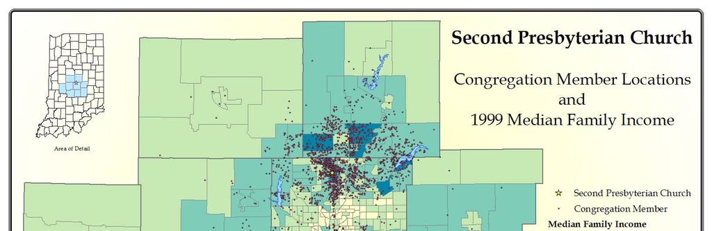
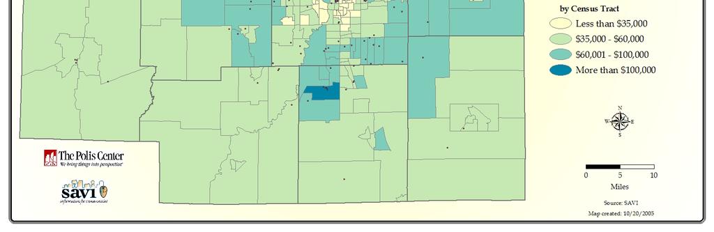
10 Harvard 2010 Religious Congregations in Marion County There are about 1,200 congregations in Marion County.
11 2010
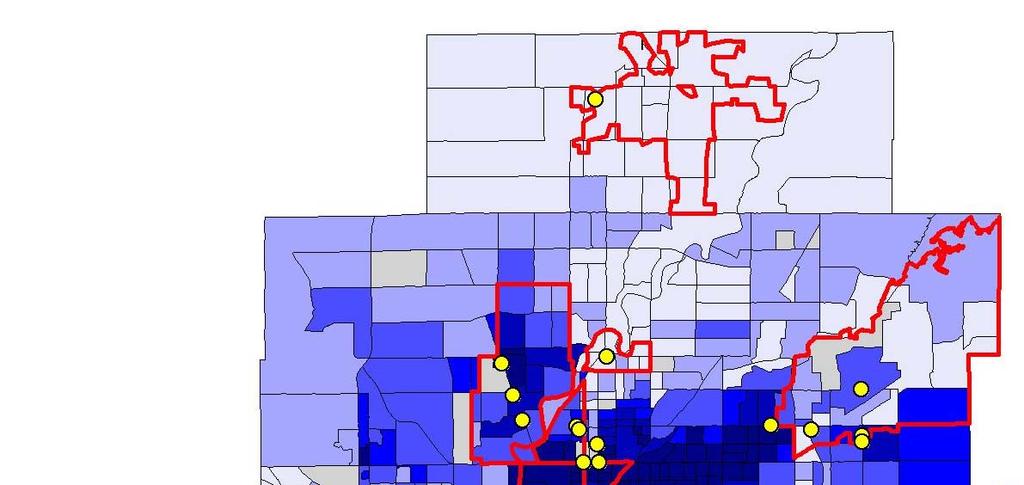
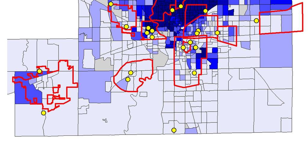
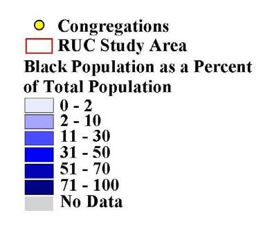
12 2010 Multi-Racial Congregations
13 2010 Problems No easy way to construct and trace denominational families across time Simplistic visualizations Does not capture denominational complexity Lacks range and proportionality
14 2010 Indiana s Religious Membership Largest Religious Tradition Baptist Catholic Christian Lutheran Mennonite Methodist (Number indicates adherents as percent of population) 23% 6% 24% 10% 23% 26% 21% 9% 8% 7% 10% 10% 10% 17% 9% 14% 18% 9% 11% 13% 7% 10% 8% 18% 14% 35% 8% 14% 11% 11% 9% 20% 13% 9% 17% 6% 12% 6% 8% 16% 10% 20% 8% 9% 8% 15% 13% 10% 12% 12% 18% 11% 12% 10% 10% 9% 9% 9% 24% 7% 22% 10% 7% 10% 13% 35% 19% 13% 16% 11% 19% 14% 23% 15% 14% 14% 25% 19% 24% 16% 13% 10% 19% 58% 15% 21% 19% 21% 13% 18% 33% 22%
15 2010 User Requirements Typology Construction Select from a list of pre defined typologies Define new typologies on the fly Aggregate data to user defined typologies Data Additions and Manipulations User supplied data Web services New fields and re coding User Defined Geographies
16 2010 Visualization Requirements View range and relative size of denominational types within the same geography or across geographies Order the visualizations by user defined measures of relative proximity and distance (e.g., theological proximity/distance, ecclesiastical proximity/distance, political proximity/distance, etc. Compare multiple geographies

17 2010 Bubble Chart

18 2010 Tree Maps

19 2010 Proximity and Size
20 2010 Multivariate Visualization
21 2010 Geographically Comparative Multivariate Visualization

22 2010 Zone of Dominance
23 2010 Pareto GIS Pareto principle (80/20): 80% of the effects come from 20% of the causes We often do not need the full analytical functionality of ArcGIS 9.3 to accomplish what humanists need T.Harris, L.Rouse, and S.Bergeron, The Geospatial Semantic Web, Pareto GIS, and the Humanities, in D.Bodenhamer, J.Corrigan, and T.Harris, eds., The Spatial Humanities: GIS and the Future of Humanities Scholarship (Indiana University Press, 2010),
24 2010 Redefining GIS Moving beyond ESRI Making GIS truly multimodal Opening GIS to Web 2.0, VREs, and immersive environments Creating collaborative spaces Developing a new epistemology (nonlinear, fluid, reflexive)
25 2010 Web 2.0 Tools/Platforms Wikis Mash Ups Blogs Social networking sites Volunteered video VREs Games Mobile devices
26 2010 Collective Intelligence Harness the problem solving capabilities of a networked and communicating group of participant collaborators Uses Web 2.0 and Grid technologies Wiki is prime example: based on compromise and consensus (old tradition) but leading to new structures of knowledge Levy, Collective Intelligence (1997)
27 2010 Participatory Learning Participatory Learning includes the ways in which new technologies enable learners (of any age) to contribute in diverse ways to individual and shared learning goals. Through games, wikis, blogs, virtual environments, social network sites, cell phones, mobile devices, and other digital platforms, learners can participate in virtual communities where they share ideas, comment upon one another's projects, and plan, design, advance, implement, or simply discuss their goals and ideas together. McArthur Foundation, 2008
28 2010 Spatial Humanities Spatial humanities is an explicit recognition of the reciprocal influence of geographic and constructed space on culture and society. Embraces all spatial technologies but bends them toward the humanities. Multidisciplinary and multimodal. Links time, space, and culture dynamically. Joins humanities and GIScience
29 2010 Geospatial Web Neogeography Volunteered Geographic Information (VGI) Virtual globes, APIs, mash ups, and social networking Geospatial semantic searching
30 2010 Past, Present, and Future

31 2010 Virtual Globes

32 2010 Spatial 3D

33 2010 Wikimapia

34 2010 Flickr

35 2010 VGI Mash-up

36 2010 Immersive Visualization

37 2010 Spatial VR

38 2010 Past, Present, and Future
39 2010 Opportunities Life paths and spatial narratives Socio spatial networks Virtual reality/immersion Gaming and simulations Practice theory Deep mapping/deep contingency
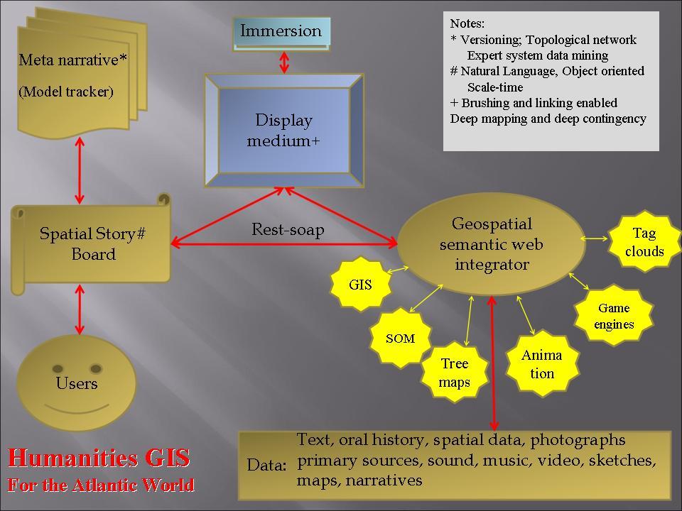
40 2010 Deep Mapping Multi media Multi layered Open to negotiation Famed as conversation Visual and immersive
41 2010 New Vision New spatial collaboratories that allow Retrieval Contextualization Hypothesis building Flexible narration Integration into knowledge networks Virtual Research Laboratories(VRL) GRID+Web 2.0+Spatial Technologies
42 2010 Future of Spatial Humanities A unique post modern scholarship with real and conceptual space as an integrating and animating framework : Visual and experiential Multiple perspectives Complex environments Simultaneous events But how to prove the case?
43 2010 Testing the Case Religion and the Atlantic World How does religion as a spatial actor shape the Atlantic World? What are its paths of transmission? What spaces does it occupy and traverse? What are the proximate others that contest religious spaces? How does physical, relative, and conceptual space shape religion in the Atlantic World?
44 2010 Other Questions How does religion alter space? What is its spatial logic? How does religion affect the imaging (not imagining) of space? What spatial processes accompany changing conceptualizations of religion? What methods/technologies does the project invite/require?
45 2010 Religion and the Atlantic World Project Criteria Make space explicit Address postmodern humanities Agency Fluidity Simultaneity Contingency Uncertainty Ambiguity Multiple narratives Recognize problems with evidence, skills Reconcile epistemologies Make tools responsive to humanities Participatory platforms Religion and Atlantic World as a Testbed
46 2010 Themes Competing spatial schemes (geographical/conceptual) Discontinuous space and time Imagined communities Negotiating space Movement/flux Scale (autonomous, discontinuous, intersecting, competing) Spatio temporal networks Spatial and temporal fluidity Emergent realities De territorialization/re territorialization Recursivity/Process
47 2010 Deep Mapping Environment Characteristics Alternate realities Fluid conceptions of space Simultaneity Multi nodal/multi perspective Multi scalar Movement Alternate mapping schemes Linked space /time Discontinuous time/space/scale Robust visualizations
48 2010
Beyond GIS: The Promise of Spatial Humanities
 2007 Beyond GIS: The Promise of Spatial David J. Bodenhamer The Polis Center Indiana University Purdue University, Indianapolis Virtual Center for Spatial Purdue University November 7, 2014 2007 An Epistemological
Dynamic Maps and Historical Context
 Dynamic Maps and Historical Context Jeanette Zerneke International Joint GIS-IDEAS and PNC/ECAI Conference December 2008 Dynamic Maps Roles and Functions of Dynamic Maps in Cultural Collections and Atlases
Space-adjusting Technologies and the Social Ecologies of Place
 Space-adjusting Technologies and the Social Ecologies of Place Donald G. Janelle University of California, Santa Barbara Reflections on Geographic Information Science Session in Honor of Michael Goodchild
Modeling forest insect infestation: GIS and agentbased
 Modeling forest insect infestation: GIS and agentbased approaches Taylor Anderson and Suzana Dragićević 2014 Esri Canada s Annual User Conference October 7 th, Toronto, Canada Presentation Overview Emerald
GRADE 5 SOCIAL STUDIES SOCIAL STUDIES APPLICATION. SOCIAL STUDIES STANDARDS for Grade 5
 GRADE 5 SOCIAL STUDIES The Archdiocese of Cincinnati has established the following Social Studies standards based on the most current teachings which are aligned to Ohio New Learning Social Studies Standards.
GIS Visualization: A Library s Pursuit Towards Creative and Innovative Research
 GIS Visualization: A Library s Pursuit Towards Creative and Innovative Research Justin B. Sorensen J. Willard Marriott Library University of Utah justin.sorensen@utah.edu Abstract As emerging technologies
A Correlation of. Eastern Hemisphere. Ohio s Learning Standards Social Studies: K-12 Grade 6
 A Correlation of Eastern Hemisphere To Grade 6 to,, Grade 6 Introduction This document demonstrates how, Eastern Hemisphere, Ohio Edition, meets : K-12 Social Studies for Grade 6. Correlation page references
Brazil Paper for the. Second Preparatory Meeting of the Proposed United Nations Committee of Experts on Global Geographic Information Management
 Brazil Paper for the Second Preparatory Meeting of the Proposed United Nations Committee of Experts on Global Geographic Information Management on Data Integration Introduction The quick development of
Dublin City Schools Social Studies Graded Course of Study Grade 5 K-12 Social Studies Vision
 K-12 Social Studies Vision The Dublin City Schools K-12 Social Studies Education will provide many learning opportunities that will help students to: develop thinking as educated citizens who seek to understand
GRADE 6 SOCIAL STUDIES SOCIAL STUDIES APPLICATION. SOCIAL STUDIES STANDARDS for Grade 6
 GRADE 6 SOCIAL STUDIES The Archdiocese of Cincinnati has established the following Social Studies standards based on the most current teachings which are aligned to Ohio New Learning Social Studies Standards.
Cartographic and Geospatial Futures
 Cartographic and Geospatial Futures 1. Web Cartography, WebGIS, & Virtual Globes--New Roles for Maps, GIS, and GIS professionals 2. Map Mashups, the Neo Neo-geography Movement, & Crowd-sourcing Geospatial
HISTORY 1XX/ DH 1XX. Introduction to Geospatial Humanities. Instructor: Zephyr Frank, Associate Professor, History Department Office: Building
 HISTORY 1XX/ DH 1XX Introduction to Geospatial Humanities Instructor: Zephyr Frank, Associate Professor, History Department Office: Building 200-332 Course Description This course introduces undergraduate
for an Informed Analysis of A Socio-Economic Perspective Adrijana Car, Marike Bontenbal and Marius Herrmann
 Creating a GIS-Base for an Informed Analysis of Tourism Development: A Socio-Economic Perspective Adrijana Car, Marike Bontenbal and Marius Herrmann adrijana.car@gutech.edu.om edu GSS 2012 Affiliated to:
GIS Institute Center for Geographic Analysis
 GIS Institute Center for Geographic Analysis Welcome Intensive training in the application of GIS to research Collection, management, analysis, and communication of spatial data Topics include: data collection,
An Ontology-based Framework for Modeling Movement on a Smart Campus
 An Ontology-based Framework for Modeling Movement on a Smart Campus Junchuan Fan 1, Kathleen Stewart 1 1 Department of Geographical and Sustainability Sciences, University of Iowa, Iowa City, IA, 52242,
geographic patterns and processes are captured and represented using computer technologies
 Proposed Certificate in Geographic Information Science Department of Geographical and Sustainability Sciences Submitted: November 9, 2016 Geographic information systems (GIS) capture the complex spatial
Lesson 16: Technology Trends and Research
 http://www.esri.com/library/whitepapers/pdfs/integrated-geoenabled-soa.pdf GEOG DL582 : GIS Data Management Lesson 16: Technology Trends and Research Overview Learning Objective Questions: 1. Why is integration
DANIEL WILSON AND BEN CONKLIN. Integrating AI with Foundation Intelligence for Actionable Intelligence
 DANIEL WILSON AND BEN CONKLIN Integrating AI with Foundation Intelligence for Actionable Intelligence INTEGRATING AI WITH FOUNDATION INTELLIGENCE FOR ACTIONABLE INTELLIGENCE in an arms race for artificial
The Kenton County School District A System of Excellence Social Studies 4.1 Core Content for Assessment
 Big Idea: Government and Civics The study of government and civics allows students to understand the nature of government and the unique characteristics of American democracy, including its fundamental
Pathways. Pathways through the Geography Major
 Pathways through the Major majors may structure their course selections around a sub-field of. Pathways are suggestions for classes in, in related disciplines, and skills training. Each pathway includes
Grade 6 Social Studies
 Unit Title: Africa : Movement Location Place Human Region : Subject/Course: 6 th Grade Social Studies Essential Questions: peoples, cultures and ideas of the world? How is a location identified using map
Smart Cities and Urban Governance. The urbanapi Project: Bologna Case Study David C. Ludlow, Maria Paola Mauri, Chiara Caranti
 1 ABSTRACT Smart Cities and Urban Governance. The urbanapi Project: Bologna Case Study David C. Ludlow, Maria Paola Mauri, Chiara Caranti (David C. Ludlow, UWE University of the West of England, Bristol-
A Geographer s role in a Google Maps World. Jeremy Bartley ESRI
 A Geographer s role in a Google Maps World Jeremy Bartley ESRI 1 It is a good time to be a Geographer. 2 Microsoft, Google, Yahoo, and others are pushing geographic awareness to the general public Providing
Scenario development for reaching urban and environmental planning integration in the context of climate change*.
 Scenario development for reaching urban and environmental planning integration in the context of climate change*. PhD (cand) Verónica Zagare (TUDelft, ) Dr. Diego Sepúlveda Carmona (TUDelft) September
Exploring Potential Human Activities in Physical and Virtual Spaces: A Spatio-temporal temporal GIS Approach
 Exploring Potential Human Activities in Physical and Virtual Spaces: A Spatio-temporal temporal GIS Approach Hongbo Yu Department of Geography, The University of Tennessee Knoxville, TN 37996-0925, USA
XXIII CONGRESS OF ISPRS RESOLUTIONS
 XXIII CONGRESS OF ISPRS RESOLUTIONS General Resolutions Resolution 0: Thanks to the Czech Society commends: To congratulate The Czech Society, its president and the Congress Director Lena Halounová, the
Techniques for Science Teachers: Using GIS in Science Classrooms.
 Techniques for Science Teachers: Using GIS in Science Classrooms. After ESRI, 2008 GIS A Geographic Information System A collection of computer hardware, software, and geographic data used together for
Northwestern Consolidated Schools of Shelby County. Curriculum. World Studies (Eastern Hemisphere) Prepared by. Rich Ballard
 Prepared by. Rich Ballard") Northwestern Consolidated Schools of Shelby County Curriculum World Studies (Eastern Hemisphere) 7th Grade Prepared by Rich Ballard 2012-2013 1 Triton Central Middle School Vision Statement We are committed
Northwestern Consolidated Schools of Shelby County Curriculum World Studies (Eastern Hemisphere) 7th Grade Prepared by Rich Ballard 2012-2013 1 Triton Central Middle School Vision Statement We are committed
2013 AND 2025 THE FUTURE OF GIS
 THE FUTURE OF GIS 2013 AND 2025 What is the state of geospatial computing today? What are the issues today? Unresolved problems What will geospatial computing be like in 2025? What issues will be of concern
Activity of the GIS Volunteer in the East Japan Great Earthquake Disaster
 ISO/TC 211 Geographic information/geomatics Activity of the GIS Volunteer in the East Japan Great Earthquake Disaster KOICHI HIRATA Japan Association of Surveyors hirata@geo.or.jp ISO/TC 211 Geographic
GIS for Crime Analysis. Building Better Analysis Capabilities with the ArcGIS Platform
 GIS for Crime Analysis Building Better Analysis Capabilities with the ArcGIS Platform Crime Analysis The Current State One of the foundations of criminological theory is that three things are needed for
Vision 2020: Focus on the Future. Michael F. Goodchild University of California Santa Barbara
 Vision 2020: Focus on the Future Michael F. Goodchild University of California Santa Barbara A little context Gore, Earth in the Balance, 1992 a single portal to Earth information Fall 1997 Tom Kalil,
Your web browser (Safari 7) is out of date. For more security, comfort and. the best experience on this site: Update your browser Ignore
 is out of date. For more security, comfort and. the best experience on this site: Update your browser Ignore") Your web browser (Safari 7) is out of date. For more security, comfort and Activityengage the best experience on this site: Update your browser Ignore Introduction to GIS What is a geographic information
Your web browser (Safari 7) is out of date. For more security, comfort and Activityengage the best experience on this site: Update your browser Ignore Introduction to GIS What is a geographic information
Esri and GIS Education
 Esri and GIS Education Organizations Esri Users 1,200 National Government Agencies 11,500 States & Regional Agencies 30,800 Cities & Local Governments 32,000 Businesses 8,500 Utilities 12,600 NGOs 11,000
Oakland County Parks and Recreation GIS Implementation Plan
 Oakland County Parks and Recreation GIS Implementation Plan TABLE OF CONTENTS 1.0 Introduction... 3 1.1 What is GIS? 1.2 Purpose 1.3 Background 2.0 Software... 4 2.1 ArcGIS Desktop 2.2 ArcGIS Explorer
Geography for the 2020 Round of Census
 Boundaries Key Census Data EA Id Population Male Female EA Id Area EA Id Num HH Avg HH size Geography for the 2020 Round of Census Linda Peters, Esri lpeters@esri.com Integration of Statistical and Geospatial
Basics of GIS. by Basudeb Bhatta. Computer Aided Design Centre Department of Computer Science and Engineering Jadavpur University
 Basics of GIS by Basudeb Bhatta Computer Aided Design Centre Department of Computer Science and Engineering Jadavpur University e-governance Training Programme Conducted by National Institute of Electronics
Introduction to ArcGIS Maps for Office. Greg Ponto Scott Ball
 Introduction to ArcGIS Maps for Office Greg Ponto Scott Ball Agenda What is Maps for Office? Platform overview What are Apps for the Office? ArcGIS Maps for Office features - Visualization - Geoenrichment
Manual of Digital Earth
 V8.0 March 27, 2018 International Society for Digital Earth Manual of Digital Earth (Tentative Title) OUTLINE Foreword Chapter 1 Understanding Digital Earth 1.1 Origins and Precursors of Digital Earth
Geographic Information Systems and Science: Today and Tomorrow. Michael F. Goodchild University of California Santa Barbara
 Geographic Information Systems and Science: Today and Tomorrow Michael F. Goodchild University of California Santa Barbara Geospatial technologies Positioning on the Earth s surface GPS, RFID Acquisition
USGIF Essential Body of Knowledge Competency Areas
 GEOINT Job/Practice Analysis USGIF, in consultation with psychometric consultants and the GEOINT community, executed a job/practice analysis to identify common competencies within the GEOINT profession.
Diverse Places 3 days
 AS Level Geography Edexcel Diverse Places 3 days Deliver two days of fieldwork within a dynamic human environment and cover the recommended themes in depth. Fieldwork in these locations provides a contrast
ArcGIS Platform For NSOs
 ArcGIS Platform For NSOs Applying GIS and Spatial Thinking to Official Statistics Esri UC 2014 Demo Theater Applying GIS at the NSO Generic Statistical Business Process Model (GSBPM) 1 Specify Needs 2
GEOGRAPHIC INFORMATION SYSTEMS Session 8
 GEOGRAPHIC INFORMATION SYSTEMS Session 8 Introduction Geography underpins all activities associated with a census Census geography is essential to plan and manage fieldwork as well as to report results
GIS and Community Health. GIS and Community Health. Institutional Context and Interests in GIS Development. GIS and Community Health
 GIS and Community Health GIS and Community Health Some critiques of GIS emphasize the potentially harmful social consequences of the diffusion of GIS technology, including reinforcing the power of state
Geography. Programme of study for key stage 3 and attainment target (This is an extract from The National Curriculum 2007)
") Geography Programme of study for key stage 3 and attainment target (This is an extract from The National Curriculum 2007) Crown copyright 2007 Qualifications and Curriculum Authority 2007 Curriculum aims
Geography Programme of study for key stage 3 and attainment target (This is an extract from The National Curriculum 2007) Crown copyright 2007 Qualifications and Curriculum Authority 2007 Curriculum aims
What is GIS and How Can It Help Me?
 esri European User Conference Madrid 2011 What is GIS and How Can It Help Me? Jaime Nieves Ignacio Vázquez esri spain «Knowing where things are, and why, is essential to rational decision making.» Jack
The Church Demographic Specialists
 The Church Demographic Specialists Easy-to-Use Features Map-driven, Web-based Software An Integrated Suite of Information and Query Tools Providing An Insightful Window into the Communities You Serve Key
Scalar Politics in North American Energy Governance
 Scalar Politics in North American Energy Governance 1 2 http://switchboard.nrdc.org/blogs/ddroitsch/tar%20sands%20pipeline%20boom.jpg 3 Transnational Capital Local Decision-Making 4 Scale Scale has no
What are we like? Population characteristics from UK censuses. Justin Hayes & Richard Wiseman UK Data Service Census Support
 What are we like? Population characteristics from UK censuses Justin Hayes & Richard Wiseman UK Data Service Census Support Who are we? Richard Wiseman UK Data Service / Jisc Justin Hayes UK Data Service
Lesson Quizzes (Individual assessments for each lesson) Social Studies Alive! Our Community and Beyond Lesson 1-6
 Social Studies Alive! Our Community and Beyond Lesson 1-6") 7.1 Basic Geographic Literacy 7.1.3.A-Identigy how basic geographic tools are used to organize and interpret information about people, places and environment. 7.3 Human Characteristics of Places and Regions
7.1 Basic Geographic Literacy 7.1.3.A-Identigy how basic geographic tools are used to organize and interpret information about people, places and environment. 7.3 Human Characteristics of Places and Regions
Applying Health Outcome Data to Improve Health Equity
 Applying Health Outcome Data to Improve Health Equity Devon Williford, MPH, Health GIS Specialist Lorraine Dixon-Jones, Policy Analyst CDPHE Health Equity and Environmental Justice Collaborative Mile High
Your web browser (Safari 7) is out of date. For more security, comfort and. the best experience on this site: Update your browser Ignore
 is out of date. For more security, comfort and. the best experience on this site: Update your browser Ignore") Your web browser (Safari 7) is out of date. For more security, comfort and lesson the best experience on this site: Update your browser Ignore Political Borders Why are the borders of countries located
Your web browser (Safari 7) is out of date. For more security, comfort and lesson the best experience on this site: Update your browser Ignore Political Borders Why are the borders of countries located
The Case for Space in the Social Sciences
 The Case for Space in the Social Sciences Don Janelle Center for Spatially Integrated Social Science University of California, Santa Barbara Roundtable on Geographical Voices and Geographical Analysis
Metropolitan Wi-Fi Research Network at the Los Angeles State Historic Park
 Metropolitan Wi-Fi Research Network at the Los Angeles State Historic Park Vidyut Samanta vids@remap.ucla.edu Chase Laurelle Alexandria Knowles chase@remap.ucla.edu Jeff Burke jburke@remap.ucla.edu Fabian
Mapping Religious Cyberscapes:
 Mapping Religious Cyberscapes: Google and User Generated Religion Dr. Matthew Zook Department of Geography University of Kentucky New Technologies and Interdisciplinary Research on Religion, Harvard University
WS/FCS Unit Planning Organizer
 WS/FCS Unit Planning Organizer Subject(s) Social Studies Conceptual Lenses Grade/Course 3rd Place Unit of Study Five Themes of Geography Location Unit Title Pacing Geo Explorers 20-22 days Human environment
School of Geography and Geosciences. Head of School Degree Programmes. Programme Requirements. Modules. Geography and Geosciences 5000 Level Modules
 School of Geography and Geosciences Head of School Degree Programmes Graduate Diploma: Dr W E Stephens Health Geography Research Environmental History and Policy (see School of History) M.Res.: M.Litt.:
Think Global, Map Local! Introducing the. Open Green Map
 Think Global, Map Local! Introducing the Open Green Map Green Map System: Promoting inclusive participation in sustainable community development since 1995 Engaging over 550 communities in 54 countries,
GIS Applications on Environmental Education in Taiwan
 GIS Applications on Environmental Education in Taiwan Track: Education Authors: Yu-Chen Lai, Mei-Ling Yeh, Tien-Yin Chou Abstract GIS is a perfect vehicle to deliver environmental knowledge and spatial
Enriching the GIScience Research Agenda: Fusing Augmented Reality (AR) and Location Based Social Networks (LBSN)
 and Location Based Social Networks (LBSN)") Enriching the GIScience Research Agenda: Fusing Augmented Reality (AR) and Location Based Social Networks (LBSN) Chengbi Liu and Sven Fuhrmann Department of Geography and Geoinformation Science George
Enriching the GIScience Research Agenda: Fusing Augmented Reality (AR) and Location Based Social Networks (LBSN) Chengbi Liu and Sven Fuhrmann Department of Geography and Geoinformation Science George
ARCHAVE : A Virtual Reality Interface for Archaeological 3D GIS. Master s Thesis Proposal by Daniel Acevedo Feliz
 ARCHAVE : A Virtual Reality Interface for Archaeological 3D GIS Master s Thesis Proposal by Daniel Acevedo Feliz Brown University February 4, 2000 Presentation Outline 1.- Motivation and definitions. Motivation
Key Issue #1 - Why is Geography a Science?
 AP Human Geography - 1 Rubenstein s The Cultural Landscape Chapter 1: Thinking Geographically Introduction to Note Packets Reading the textbook and taking notes while reading are NECESSARY steps in processing
BEFORE METHOD: Analytic Tactics
 BEFORE METHOD: Analytic Tactics The making of histories An analysis that seeks to recover how a condition, a system, a subject, were made. The diverse elements that got assembled to make that condition
TRAITS to put you on the map
 TRAITS to put you on the map Know what s where See the big picture Connect the dots Get it right Use where to say WOW Look around Spread the word Make it yours Finding your way Location is associated with
Conceptual study of Web-based PPGIS for Designing Built Environment: Identifying Housing Location Preferences in Littleborough
 Conceptual study of Web-based PPGIS for Designing Built Environment: Identifying Housing Location Preferences in Littleborough Shrabanti Hira *1, S M Labib 1 1 SEED, University of Manchester March 31,
Idaho Content Standards Science Grade: 3 - Adopted: 2006
 Main Criteria: Idaho Content Standards Secondary Criteria: Subjects: Science, Social Studies Grade: 3 Correlation Options: Show Correlated Idaho Content Standards Science Grade: 3 - Adopted: 2006 STANDARD
G. I. Science Education: A Computing Perspective
 A Position Statement on G. I. Science Education: A Computing Perspective (A Panel Discussion in UCGIS Summer Assembly 2008) By Shashi Shekhar McKnight Distinguished University Professor Faculty of Computer
A General Framework for Conflation
 A General Framework for Conflation Benjamin Adams, Linna Li, Martin Raubal, Michael F. Goodchild University of California, Santa Barbara, CA, USA Email: badams@cs.ucsb.edu, linna@geog.ucsb.edu, raubal@geog.ucsb.edu,
Minnesota K-12 Academic Standards in Social Studies. Grade 4: Geography of North America
 Minnesota K-12 Academic s in Social Studies Grade 4: Geography of North America 4 Describe how people take 1. Democratic government action to influence a depends on informed and decision on a specific
INTEGRATING GEOSPATIAL PERSPECTIVES IN THE ANTHROPOLOGY CURRICULUM AT THE UNIVERSITY OF NEW MEXICO (UNM)
") INTEGRATING GEOSPATIAL PERSPECTIVES IN THE ANTHROPOLOGY CURRICULUM AT THE UNIVERSITY OF NEW MEXICO (UNM) VERONICA ARIAS HEATHER RICHARDS JUDITH VAN DER ELST DEPARTMENT OF ANTHROPOLOGY MARCH 2005 INTEGRATING
INTEGRATING GEOSPATIAL PERSPECTIVES IN THE ANTHROPOLOGY CURRICULUM AT THE UNIVERSITY OF NEW MEXICO (UNM) VERONICA ARIAS HEATHER RICHARDS JUDITH VAN DER ELST DEPARTMENT OF ANTHROPOLOGY MARCH 2005 INTEGRATING
The Emerging Role of Enterprise GIS in State Forest Agencies
 The Emerging Role of Enterprise GIS in State Forest Agencies Geographic Information System (GIS) A geographic information system (GIS) is a computer software system designed to capture, store, manipulate,
TEMPLATE FOR CMaP PROJECT
 TEMPLATE FOR CMaP PROJECT Project Title: Native Utah Plants Created by: Anna Davis Class: Box Elder 2008 Project Description Community Issue or Problem Selected -How project evolved? Community Partner(s)
Alaska Content and Performance Standards Science Grade: 7 - Adopted: Concepts of Life Science (SC1, SC2, SC3)
") Main Criteria: Alaska Content and Performance Standards Secondary Criteria: Subjects: Science, Social Studies Grade: 7 Correlation Options: Show Correlated AK.C1. Alaska Content and Performance Standards
Main Criteria: Alaska Content and Performance Standards Secondary Criteria: Subjects: Science, Social Studies Grade: 7 Correlation Options: Show Correlated AK.C1. Alaska Content and Performance Standards
Application of WebGIS and VGI for Community Based Resources Inventory. Jihn-Fa Jan Department of Land Economics National Chengchi University
 Application of WebGIS and VGI for Community Based Resources Inventory Jihn-Fa Jan Department of Land Economics National Chengchi University OUTLINE Introduction Methodology Results Conclusions 2 MOTIVATION
Cognitive Engineering for Geographic Information Science
 Cognitive Engineering for Geographic Information Science Martin Raubal Department of Geography, UCSB raubal@geog.ucsb.edu 21 Jan 2009 ThinkSpatial, UCSB 1 GIScience Motivation systematic study of all aspects
Time Series Analysis with SAR & Optical Satellite Data
 Time Series Analysis with SAR & Optical Satellite Data Thomas Bahr ESRI European User Conference Thursday October 2015 harris.com Motivation Changes in land surface characteristics mirror a multitude of
Chapter 1: Introduction to Safety and Ethics
 Core Curriculum Standards Met by Each Chapter On the Right Trail meets Utah s Social Studies Core Curriculum Standards for grades 3-7. Each chapter has specific standard objectives, which are met by the
GEOGRAPHY 350/550 Final Exam Fall 2005 NAME:
 1) A GIS data model using an array of cells to store spatial data is termed: a) Topology b) Vector c) Object d) Raster 2) Metadata a) Usually includes map projection, scale, data types and origin, resolution
ESSENTIAL CONCEPTS AND SKILL SETS OF THE IOWA CORE CURRICULUM
 ESSENTIAL CONCEPTS AND SKILL SETS OF THE IOWA CORE CURRICULUM SOCIAL STUDIES PROVIDED BY THE IOWA DEPARTMENT OF EDUCATION INTRODUCTION Social studies is the integrated study of the social sciences and
EVALUATION AND APPROVAL OF ATLASES
 EVALUATION AND APPROVAL OF ATLASES Elementary and Secondary Education Frame of Reference Ministère de l Éducation, du Loisir et du Sport Direction des ressources didactiques Bureau d approbation du matériel
US National Spatial Data Infrastructure A Spatial Framework for Governance and Policy Development to Enable a Location-Based Digital Ecosystem
 GeoPlatform Workshop 7 Dec 2016, Department of the Interior Washington, D.C. US National Spatial Infrastructure A Spatial Framework for Governance and Policy Development to Enable a Location-Based Digital
Twenty Years of Progress: GIScience in Michael F. Goodchild University of California Santa Barbara
 Twenty Years of Progress: GIScience in 2010 Michael F. Goodchild University of California Santa Barbara Outline The beginnings: GIScience in 1990 Major accomplishments research institutional The future
Spatial Data Science. Soumya K Ghosh
 Workshop on Data Science and Machine Learning (DSML 17) ISI Kolkata, March 28-31, 2017 Spatial Data Science Soumya K Ghosh Professor Department of Computer Science and Engineering Indian Institute of Technology,
Gov 2.0. Encourage citizen engagement, deliver transparency, and foster collaboration with ArcGIS.
 Gov 2.0 Encourage citizen engagement, deliver transparency, and foster collaboration with ArcGIS. F E D E R A L GIS A Platform for Open Government Upon taking office, President Barack Obama issued an open
Reimaging GIS: Geographic Information Society. Clint Brown Linda Beale Mark Harrower Esri
 Reimaging GIS: Geographic Information Society Clint Brown Linda Beale Mark Harrower Esri 8 billion = Number of basemap requests per month on AGOL 14,000 = Unique requests per second 12,000 = New Items
THE PO L ITICS O F PL ACE-
 Your web browser (Safari 7) is out of date. For more security, comfort and the best experience on this site: Update your browser Ignore Activity Student Version THE PO L ITICS O F PL ACE- NAMING Why are
Maps as Research Tools Within a Virtual Research Environment.
 Maps as Research Tools Within a Virtual Research Environment. Sebastian Specht, Christian Hanewinkel Leibniz-Institute for Regional Geography Leipzig, Germany Abstract. The Tambora.org Virtual Research
8/28/2011. Contents. Lecture 1: Introduction to GIS. Dr. Bo Wu Learning Outcomes. Map A Geographic Language.
 Contents Lecture 1: Introduction to GIS Dr. Bo Wu lsbowu@polyu.edu.hk Department of Land Surveying & Geo-Informatics The Hong Kong Polytechnic University 1. Learning outcomes 2. GIS definition 3. GIS examples
S/He reports to the Programme Effectiveness Manager. Lead, review and process the development of NO GIS framework and tools.
 GIS Coordinator Location: [Africa] [Ghana] Town/City: Accra Category: Knowledge Management GIS Coordinator To provide leadership and management to cluster staff (of 2 to 3 Area Programs) by ensuring that
SOCIAL STUDIES GRADE 6. I Can Checklist REGIONS AND PEOPLE OF THE EASTERN HEMISPHERE. Office of Teaching and Learning Curriculum Division
 SOCIAL STUDIES REGIONS AND PEOPLE OF THE EASTERN HEMISPHERE GRADE 6 I Can Checklist 2018-2019 Aligned with Ohio s Learning Standards for Social Studies Office of Teaching and Learning Curriculum Division
GIScience: Current Technology. Michael F. Goodchild University of California Santa Barbara
 GIScience: Current Technology Michael F. Goodchild University of California Santa Barbara What is a GIS? A class of software designed to handle geographic information and perform virtually any conceivable
Master Syllabus Department of Geography GEOG 448: Geographic Information System Design Course Description
 Master Syllabus Department of Geography GEOG 448: Geographic Information System Design Course Description Geographic information technologies continue to drive the representation and management of complex
Your web browser (Safari 7) is out of date. For more security, comfort and. the best experience on this site: Update your browser Ignore
 is out of date. For more security, comfort and. the best experience on this site: Update your browser Ignore") Your web browser (Safari 7) is out of date. For more security, comfort and Activitydevelop the best experience on this site: Update your browser Ignore Places in the Park Why do we use symbols? Overview
Your web browser (Safari 7) is out of date. For more security, comfort and Activitydevelop the best experience on this site: Update your browser Ignore Places in the Park Why do we use symbols? Overview
correlated to the West Virginia Specific Criteria for Content and Skills Grade Seven: World Geography CC2
 correlated to the West Virginia Specific Criteria for Content and Skills Grade Seven: World Geography CC2 6/2003 2003 Introduction to McDougal Littell World Cultures and Geography: Eastern Hemisphere World
June 19 Huntsville, Alabama 1
 June 19 Huntsville, Alabama 1 Real-Time Geospatial Data: The Fusion of PI and ArcGIS Enabling Smarter Facilities Management OSIsoft and Esri Mapping and Location Analytics Platform Supporting Your Use
Exploring Digital Welfare data using GeoTools and Grids
 Exploring Digital Welfare data using GeoTools and Grids Hodkinson, S.N., Turner, A.G.D. School of Geography, University of Leeds June 20, 2014 Summary As part of the Digital Welfare project [1] a Java
SPIMA Spatial dynamics and strategic planning in metropolitan areas
 Targeted Analysis SPIMA Spatial dynamics and strategic planning in metropolitan areas Executive Summary Conference version 1 February 2018 0 1. Background To address the challenges of metropolitan development
WS/FCS Unit Planning Organizer
 WS/FCS Unit Planning Organizer Subject(s) Social Studies Conceptual Lenses Grade/Course 6 th Geography Unit of Study Unit 1: Human Geography Civilization Unit Title Social Studies 101 Culture Pacing 12
Cultural Geographies Old and New
 Cultural Geographies Old and New GG270 Winter 2013 Dr Margaret Walton-Roberts COURSE OBJECTIVES Survey the development of cultural geography from early environmental approaches, to more recent examinations