Remote Sensing Applications in Agricultural Statistics at China NBS. Yu Xinhua Department of Rural Surveys, National Bureau of Statistics(NBS)
|
|
|
- Gilbert Gibbs
- 6 years ago
- Views:
Transcription
")
1 Remote Sensing Applications in Agricultural Statistics at China NBS Yu Xinhua Department of Rural Surveys, National Bureau of Statistics(NBS)
2 Outline Introduction Remote Sensing Measurement Area Frame Survey Software & IT Infrastructure Challenges & Development
3 The new requirements of agricultural statistics in 21th century. Provide relevant data for policy making to ensure national food security. Food security has the highest priority for the development of modern agriculture. Agricultural statistics are vital information for grain development strategy. The international situation, the rapid development and profound change of agriculture and rural area in China brings up the new requirement. Meet the data gap for modern agricultural development. Grain Production Counties Development Strategy has implemented, which requires to set up statistical monitoring and evaluation system. The strategy of developing facility-based agriculture and standardizing horticulture production was set up, which requires corresponding statistics. The innovation of agricultural technology integration, mechanizing and informatization, new survey tools should be applied for these new farming. To enhance the agricultural production with social services supporting, agricultural statistics should be service-oriented, providing more relevant information to producers. To meet the needs of multi-dimension services. Markets needs timely, accurate, transparent information. Large and small area statistics are all needed. The data are needed for all major crops, include commodity crops and minor crops. Information for food quality, its production and marketing are all needed.


4 The new requirements of agricultural statistics in 21th century. New situation Food security Agriculture modernization Service-oriental New New goals goals More information Advanced vehicles Reliable data Better services New require ments Data collection capacity Data processing capacity Data analytical capacity Data delivery capacity Can the traditional agriculture statistical system meet the new requirements of 21th Century?
5 Traditional agricultural statistics become unadapted Survey schemes Counting units Survey tools The merging of sample survey and complete reporting. Does the sample designed for province population meet the needs of county and prefecture level? How to adapt the rapid change of farming structure? Mobility of sample farmers. Rapid change of Land tenure. Impact of sample farmer s subjectivity. Mainly traditional tool, such as self-report, compass and rope. Cannot efficiently deal with estimation under disaster or other rapid change Lack of necessary supervision and management. Traditional agricultural statistics cannot meet the new requirements well.


6 The support of new technologies Computer, network Geospatial information technologies Big data Technologies Policies Deepening reform Agriculture and rural policy Scientific outlook on development Best practices of peers Experience of other industries Experiences Importing new technologies, improving agricultural statistics.
, Geography Information System (GIS)and Global Positioning System(GPS), combined with computer")

.")

7 Geospatial information technologies Geospatial information technologies (3S) include Remote Sensing (RS), Geography Information System (GIS)and Global Positioning System(GPS), combined with computer and network, applied for measurement, collection, storage, management, display, analysis, spreading and application of geospatial data. In USA, Geo-IT has become one of the three hottest occupations (with Biotechnology and Nanotechnology). The ability of earth observation Big range High resolution Timeliness Can be revisited The ability of geospatial data management Huge volume data Visualization The ability of positioning Location Navigation Measurement and mapping all-weather Geo-IT and agricultural Spatial analysis statistics can be Geo-reference naturally basis integrated. Remote Sensing GIS NSS


8 中国农业统计遥感发展历程 Operation phase Crop area frame survey 2009 年 Starting phase 1 4 Pilot phase Xinjiang cotton remote sensing measurement 2010 年 Crop area remote sensing measurement pilot 2009 年 Technical 3 Maturity Industry project Pilot -- Satellite-based Implementation supporting platform for agricultural surveys 2012 年 Research Earth observation project -- Pilot of high resolution phase remote sensing for statistical surveys 2011 年 Industry project -- Data source pilot of remote sensing 2 for agricultural surveys 2009 年 863 project -- The research of key technologies for statistical surveys 2006 年 863 project -- The research of norm and application of remote sensing for agricultural surveys 2003 年
9 The research of key technologies for operational implementation of agricultural statistical remote sensing National research project to produce of key technologies Crop remote sensing identification methodology. Using geo-spatial technology to build area sampling frame for agricultural surveys. Using pilot to promote the transformation of research results of key technologies Crop area remote sensing measurement pilot will improve crop identification methods with the terrain characters and imagery availability for different regions, and develop methodology operational for specific region. Use demonstration application to break through the nexus of operational application of key technologies Crop area frame sampling survey will integrate the geo-spatial frame building, geospatial sampling, and other new technology.
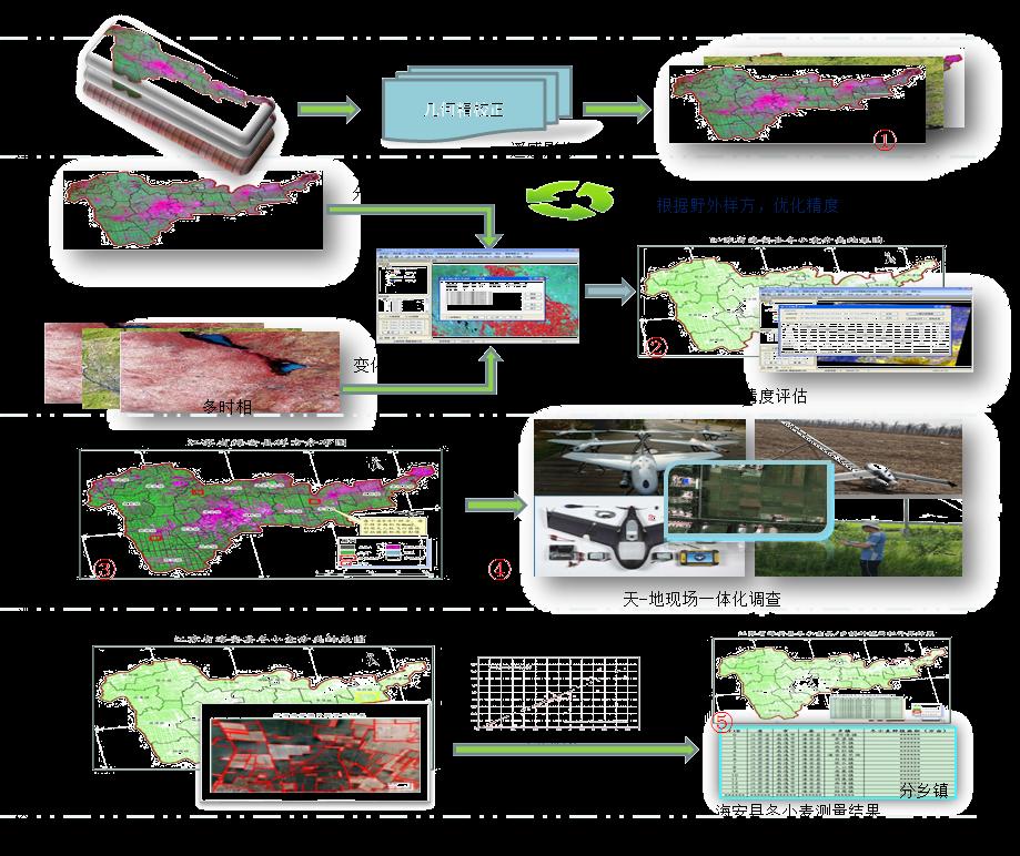
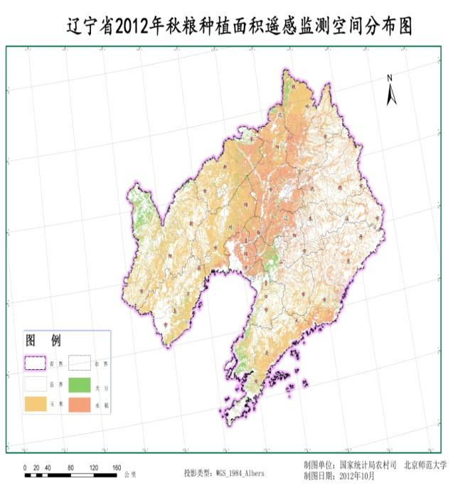
10 Building two major agricultural statistical surveys system with remote sensing. Crop area frame surveys Beginning from year 2010, crop area frame survey has been carried out at Jiangsu, Henan, Liaoning, Jilin Hubei, Anhui with county-level as population, which has replaced the traditional list-based crop survey. The building of work base for survey have completed and seasonal survey has been carried normally. Remote sensing measurement Beginning from year 2010, remote sensing measurements have been implemented at Beijing, jiangsu, Henan, Hubei, Jinlin, Liaoning, Ningxia, East part of Inner Mongolia for summer and autumn grain crops. Unmanned aircrafts(drones) and other new survey tools were used for survey and a technical system was built for operational field survey.


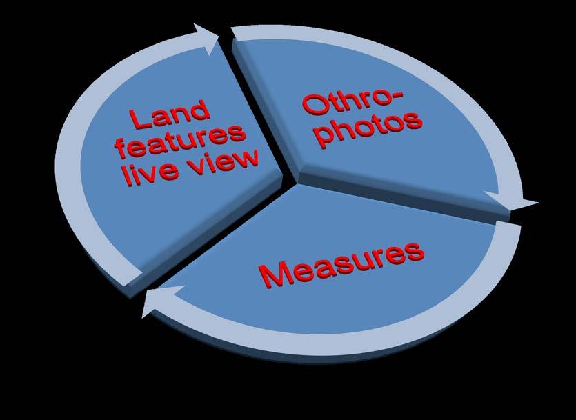
11 Improving the survey tools for agricultural surveys The first agricultural survey vehicle was developed, which integrated satellite imagery, aero-photography, field observation. So high resolution images, roadside picture and video, field agro-parameters will be collected and combined together to distill useful data for estimation. The data collection capacity of geospatial samples for crop area, growing condition and yield was formed, which provide a solution for completely, rapidly and accurately data collection for estimation of crop area, crop condition and total production.
12 Outline Introduction Remote Sensing Measurement Area Frame Survey Software & IT Infrastructure Challenges & Development


13 Current crop area remote sensing measurement Crop area remote sensing methodology was developed, which includes data collection and processing, remote sensing classification, field survey, validation, error correction and producing ASCDL as major functions. PDA survey UAV survey Imagery acquirement Field survey Identification County estimation Provincial Estimation Provincial identification +
14 Technical procedures
 were extracted and crop identification were made and finally ASCDL was")

15 Remote sensing identification Based on the current multi-phase remote sensing data, land cover ( arable land included) were extracted and crop identification were made and finally ASCDL was produced. ASCDL County-level knowledge base for identification Crop data layers Agricultural statistical land cover data layer Error analytical layers Description of county-level products. Production flow of ASCDL


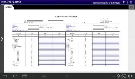
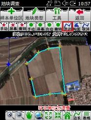
16 Field survey and sample interpretation (1) For the selected field sample, with the support of region office, UAV field survey was carried and aero-photography was captured and crop plots were delineated. Field work photos UAV photo mosaic Vectorization of sample land
17 Field survey and sample interpretation (2) Photo Captures by RPV or Mobile Devices(Tablets, smartphones) Area measurement by photos Convenient Tools Randomly Determined Lots of data to be measured


18

19 Results of remote sensing identification
20 Outline Introduction Remote Sensing Measurement Area Frame Survey Software & IT Infrastructure Challenges & Development
21 Start point Area frame was built with 2 nd agricultural census data and 2 nd land use census data. cropland segments were created as sampling unit and enough segments were sampled to meet the precision requirement. Several direct interviews of segment planting were carried by interviewer to estimate the crop area. According to the harvest season of crops, certain planting plots was selected for cropcutting and then the yield of specific crop was collected and estimated. Finally, the crop production was estimated. Subjective survey transits to objective survey Lack of data quality evaluation & supervision Traditional tools, such as ropes. Traditional sampling methodology List frame Traditional crops survey Quality Tools Sample Frame Spatial analysis, repeatable, supervised Modern survey tools. PDA&GPS. Geospatial sampling methodology Geospatial frame Crop area frame survey


22 Crop area frame survey system A primary system for crop area frame survey was developed, which includes geospatial sampling frame, segment sampling, field survey, survey data submit, estimation, quality evaluation. Detailed data on fields are collected and measuring precision is improved. The goals to change the counting unit from list to spatial fields were realized. Province Sample county Sample village Sample plot crop planting area estimates and variances of the Pilot counties in 2009 Pilot county name 辽宁法库县河南濮阳市江苏溧阳市吉林德惠市安徽凤台县 对地抽样方法空间随机抽样空间随机抽样空间随机抽样 以规则网格为初级抽样单元的分层两阶段抽样 农普与土地利用数据相结合的两阶段抽样 标准地块面积 (ha) 标准地块数量 ( 总体 ) 行政村数量 ( 总体 ) 标准地块数量 ( 样本 ) 行政村数量 ( 样本 ) 作物名称 玉米 玉米 水稻 玉米 水稻 总体总值估计值 (m 2 ) CV(%)
23 Developing of sampling frame Cultivated land updating By visual interpretation or change detection with current satellite imagery, the cultivated land polygons from the 2 nd land use census data were updated for more accurate, complete cover and no missing. Identification of major crops Using remote sensing images to identifying major crops to acquire more ancillary information. Depending the situation of data acquirement, change detection and unsupervised classification method are used for identification of target crops. Sampling units construction Division with administrative area : The cultivated land polygons are divided with administrative boundaries and the identification results was summed up by crops for each administrative area. Division with grid delineation : Land polygons were split into grid blocks of same size, and the identification results was summed up by crops for each block.


24 Sampling Two stage PPS sampling First stage: Primary sampling units, which are villages or grid blocks, were sampled. Second stage: Land segments were selected with SRS within sampled villages or grid blocks. Sampling of villages Sampling of land segments


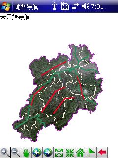
25 Field work package Field maps suites:hardcopy image of sampling villages, vector maps, maps of sampling segments. GPS task package : GPS devices are needed for area measurement of the screening survey. All the task base data and forms are packed into task package and loaded into GPS. Field maps GPS task package


26 Field survey methods Screen survey Sampling segment screen questionnaire: Collect data at the beginning of each survey round. Location, crop used area, non crop used area, field splitting, and users data are collected. Sampling village questionnaire : Collect data at the end of each year. Seasonal survey Cropping intention survey : Farmers planting intention and plan are carried at sampling segment before winter planting and summer planting. 10 farmers will be selected for survey at each sampling village. Crop area survey : Carried at winter planting, spring planting and early rice planting, summer planting period. Crop area are collected from sampling segments directly. Crop yield and production survey : Carried at summer harvest, early rice harvest and autumn harvest.
27 Outline Introduction Remote Sensing Measurement Area Frame Survey Software & IT Infrastructure Challenges & Development


28 Integrated service platform for agricultural rapid survey.


29 Overall framework 自主遥感卫星 初级产品标准处理云平台 信息产品服务平台 国家级数据资源 国家统计遥感信息共享服务平台 省级数据资源 国家级节点 北斗导航卫星 自主通讯卫星 县级数据资源 县级节点 省级节点 农业统计快速调查 区域级数据资源 中心数据资源 中心节点 区域节点


30 Data source system Developing the agricultural statistical remote sensing data source assurance system to provide required satellite imagery. Assura nce system Data produc t Satellite imagery Producing and providing data products for operational agricultural remote sensing surveys. Partner ship Exploring the data partnership with line ministries & business firms. Developing standard and norm of satellite imagery data product for agricultural remote sensing surveys. Standa rd & norm Demon stration Carrying out provincial demonstration application
31 Agricultural remote sensing survey infrastructure Data source assurance system Satellite imagery : High Resolution Satellite series, Resource Satellite series, Environmental Satellite series Partnership Line ministries : ministry of land resource, National Bureau of Mapping and Geo-information, National Geo-information Center Business firms : Oriental Roadnear, PeaceMap, China Science Geo-do Geo-spatial base data framework construction Completely covered satellite imagery : Multi-phase medium and high resolution satellite imagery, completely covered the major provinces of grain production. Level by level base geography data : Based on 2 nd land use census data, build up provincial, county-level, village-level, and plot-level base geography dataset. Other data types : Geo-referenced statistics, meteorology data, phenology data, hydrology data


32 Statistical remote sensing data sharing and service system It will realize the transformation of agricultural statistics to plane or threedimensional distribution form at spatial and regional level, which will improve the display methods and means of agricultural statistics, promote the standardization of statistical information, and enhance the ability of analysis, exploration and forecasting to agricultural statistics. Process Collection Management Distribution

33 Crop production survey vehicle

34 Unmanned Aircraft (drones)


35 Mobile data collection devices Smartphone (Explorer) GPS(Windows Mobile) PAD(Android)
36 Outline Introduction Remote Sensing Measurement Area Frame Survey Software & IT Infrastructure Challenges & Development
37 Challenges Challenges from the complexity of farming in China Complexity of farming structure in China : Lots of crop types, region difference, Non-scale farming, multiple crop rotation, intercropping and interplanting. Fragmented landscape in most regions : Except the northeast, the size of crop plots are very small. Complex terrain : There are cropping in all kinds of landscape type, plain, hill, or mountainous area Largely impacted by market, the farming structure change rapidly Following impact of the social and economical development, arable land changes very rapidly. Challenges from remote sensing technologies Time phase requirement : Because the crop planting is strongly seasonal, suitable satellite imagery must be acquired at specific period. Cloud and rain weather : Because of the constraint of cloud/rain weather and satellite passing period, the data availability is very limited for large scale crop area remote sensing. Identification accuracy : At complex situation, the accuracy of remote sensing identification must be researched to improve substantially. Challenges from operational implementation Cost : It includes the infrastructure, purchase and process of imagery, geo-spatial framework, purchase of survey tools. If it were applied at national wide, bulks of fund are required. Worklord : For the timeliness, huge volume satellite imagery must be processed in short time, and field work finished rapidly. The workload is huge. More manpower and resource are needed.

38 Future development Improvement of technical ability, efficiency, data quality and services Operational application Evaluation New system Available Data Fully operational application Survey means Integrated survey technologies to capture from space, air, fields Estimation Spatial sampling Small area estimation Model estimation Self-contained methodology Data basis Remote sensin g data Base geogra phic data Statis tical data Data source assurance system Social and economi c data Climat e data Agricultural statistical OneMap
39 Thanks for your attention!
Surveying,Mapping and Geoinformation Services System for the Major Natural Disasters Emergency Management in China
 Surveying,Mapping and Geoinformation Services System for the Major Natural Disasters Emergency Management in China 21 February 2013, Bangkok, Thailand Contents 2 1 2 3 4 Working Mechanism Geoinformation
Application of Internet+ Field Survey Technology in China s Land Management
 Application of Internet+ Field Survey Technology in China s Land Management Zheng Yu,China Land Surveying and Planning Institute, Land Survey Agency Key words: Internet+, Field Survey, Land Management
Design, Development and Application of Northeast Asia Resources and Environment Scientific Expedition Data Platform
 September, 2011 J. Resour. Ecol. 2011 2(3) 266-271 DOI:10.3969/j.issn.1674-764x.2011.03.010 www.jorae.cn Journal of Resources and Ecology Vol.2 No.3 NE Asia Design, Development and Application of Northeast
FY-3/FY-4 satellite development/ application review and future plan
 The 4 th THORPEX-Asia science workshop&9 th ARC meeting, Oct. 30, 2012 FY-3/FY-4 satellite development/ application review and future plan Tang Shihao E-mail : tangsh@cma.gov.cn Tel/Fax: 86-10-68407250
SEASONAL AGRICULTURE SURVEY (SAS) The Overview of the Multiple Frame Sample Survey in Rwanda
 The Overview of the Multiple Frame Sample Survey in Rwanda") SEASONAL AGRICULTURE SURVEY (SAS) The Overview of the Multiple Frame Sample Survey in Rwanda Sébastien MANZI Director of Economic Statistics December 16, 2013 National Institute of Statistics of Rwanda
SEASONAL AGRICULTURE SURVEY (SAS) The Overview of the Multiple Frame Sample Survey in Rwanda Sébastien MANZI Director of Economic Statistics December 16, 2013 National Institute of Statistics of Rwanda
通量数据质量控制的理论与方法 理加联合科技有限公司
 通量数据质量控制的理论与方法 理加联合科技有限公司 通量变量 Rn = LE + H + G (W m -2 s -1 ) 净辐射 潜热 感热 地表热 通量 通量 通量 通量 Fc (mg m -2 s -1 ) 二氧化碳通量 τ [(kg m s -1 ) m -2 s -1 ] 动量通量 质量控制 1. 概率统计方法 2. 趋势法 3. 大气物理依据 4. 测定实地诊断 5. 仪器物理依据 '
Remote sensing of haze aerosol over eastern China
 ISALSaRS'17, USTC, 21-June-2017 China University of Mining and Technology Remote sensing of haze aerosol over eastern China Qin Kai( 秦凯 ), CUMT ( 中国矿业大学 ) Wu Lixin, CSU( 中南大学 ) Wong Mansing, Hong Kong
Factors Driving the Expansion of Construction Land: A Panel Data Study of Districts and Counties in Ningbo City, China
 July, 2018 Journal of Resources and Ecology Vol. 9 No.4 J. Resour. Ecol. 2018 9(4) 365-373 DOI: 10.5814/j.issn.1674-764x.2018.04.004 www.jorae.cn Factors Driving the Expansion of Construction Land: A Panel
Cooling rate of water
 Cooling rate of water Group 5: Xihui Yuan, Wenjing Song, Ming Zhong, Kaiyue Chen, Yue Zhao, Xiangxie Li 目录. Abstract:... 2. Introduction:... 2 2.. Statement of the problem:... 2 2.2 objectives:... 2 2.3.
Improving Surface-based Data Quality through Improved Standardization of Practice and Procedures In Situ Observation Experience & Regional Needs
 Improving Surface-based Data Quality through Improved Standardization of Practice and Procedures In Situ Observation Experience & Regional Needs Dr. Li Bai China Meteorological Administration Dec.2014
Indicator: Proportion of the rural population who live within 2 km of an all-season road
 Goal: 9 Build resilient infrastructure, promote inclusive and sustainable industrialization and foster innovation Target: 9.1 Develop quality, reliable, sustainable and resilient infrastructure, including
ArcGIS 10.1 for Server OGC 标准支持. Esri 中国信息技术有限公司
 ArcGIS 10.1 for Server OGC 标准支持 Esri 中国信息技术有限公司 李光辉 DEMO OpenLayers GoogleEarth Map Services udig OWS Image Service 商业 GIS 软件 ArcGIS for Server GP Services Globe Services GeoCoding Services GeoData Services
Technological Progress, Industrial Transformation and Regional Development
 23/11/2012,RSA. London, UK Technological Progress, Industrial Transformation and Regional Development A Case Study of Yangtze River Delta Zhen Feng School of Architecture and Urban Planning, Nanjing University
能源化学工程专业培养方案. Undergraduate Program for Specialty in Energy Chemical Engineering 专业负责人 : 何平分管院长 : 廖其龙院学术委员会主任 : 李玉香
 能源化学工程专业培养方案 Undergraduate Program for Specialty in Energy Chemical Engineering 专业负责人 : 何平分管院长 : 廖其龙院学术委员会主任 : 李玉香 Director of Specialty: He Ping Executive Dean: Liao Qilong Academic Committee Director:
GEOGRAPHIC INFORMATION SYSTEMS Session 8
 GEOGRAPHIC INFORMATION SYSTEMS Session 8 Introduction Geography underpins all activities associated with a census Census geography is essential to plan and manage fieldwork as well as to report results
Source mechanism solution
 Source mechanism solution Contents Source mechanism solution 1 1. A general introduction 1 2. A step-by-step guide 1 Step-1: Prepare data files 1 Step-2: Start GeoTaos or GeoTaos_Map 2 Step-3: Convert
Introduction to RADI,CAS
 Introduction to RADI,CAS LIU Jie Director of International Cooperation Office June 22, 2016 Beijing China About RADI The RADI is an independent research institute affiliated to the Chinese Academy of Sciences
Multivariate Statistics Analysis: 多元统计分析
 Multivariate Statistics Analysis: 多元统计分析 Lecture 1: Basic Concept Jun Li ( 李军 ) School of Geography and Planning Sun Yat-Sen University, Guangzhou, China Mobile: 13922375250; Office: D307 E-mail: lijun48@mail.sysu.edu.cn;
2012 AP Calculus BC 模拟试卷
 0 AP Calculus BC 模拟试卷 北京新东方罗勇 luoyong@df.cn 0-3- 说明 : 请严格按照实际考试时间进行模拟, 考试时间共 95 分钟 Multiple-Choice section A 部分 : 无计算器 B 部分 : 有计算器 Free-response section A 部分 : 有计算器 B 部分 : 无计算器 总计 45 题 /05 分钟 8 题,55 分钟
Mapping the Urban Farming in Chinese Cities:
 Submission to EDC Student of the Year Award 2015 A old female is cultivating the a public green space in the residential community(xiaoqu in Chinese characters) Source:baidu.com 2015. Mapping the Urban
Use of Geospatial Data: Philippine Statistics Authority 1
 Use of Geospatial Data: Philippine Statistics Authority 1 1 Presentation by Lisa Grace S. Bersales at the UNSC 2016 side event on Geospatial information and earth observations: supporting official statistics
Galileo Galilei ( ) Title page of Galileo's Dialogue concerning the two chief world systems, published in Florence in February 1632.
 Title page of Galileo's Dialogue concerning the two chief world systems, published in Florence in February 1632.") Special Relativity Galileo Galilei (1564-1642) Title page of Galileo's Dialogue concerning the two chief world systems, published in Florence in February 1632. 2 Galilean Transformation z z!!! r ' = r
Special Relativity Galileo Galilei (1564-1642) Title page of Galileo's Dialogue concerning the two chief world systems, published in Florence in February 1632. 2 Galilean Transformation z z!!! r ' = r
Geospatial Big Data. Greg Scott Inter-Regional Advisor Global Geospatial Information Management United Nations Statistics Division. ggim.un.
 Geospatial Big Data Greg Scott Inter-Regional Advisor Global Geospatial Information Management United Nations Statistics Division Positioning geospatial information to address global challenges ggim.un.org
GIS Workshop Data Collection Techniques
 GIS Workshop Data Collection Techniques NOFNEC Conference 2016 Presented by: Matawa First Nations Management Jennifer Duncan and Charlene Wagenaar, Geomatics Technicians, Four Rivers Department QA #: FRG
Development of Geospatial Information in Indonesia: Progress & Challenge
 Development of Geospatial Information in Indonesia: Progress & Challenge Dr. Nurwadjedi Sarbini Deputy of Thematic Geospatial Information Geospatial Information Agency (BIG) Geosmart Asia, September 29
Geospatial Information and Services for Disasters (GIS4D)
") Geospatial Information and Services for Disasters (GIS4D) 31 July 2017 Tae Hyung KIM ICT and Disaster Risk Reduction Division (IDD) UNESCAP 1 About ESCAP Who is ESCAP? United Nations Economic and Social
Geospatial Information and Services for Disasters (GIS4D) 31 July 2017 Tae Hyung KIM ICT and Disaster Risk Reduction Division (IDD) UNESCAP 1 About ESCAP Who is ESCAP? United Nations Economic and Social
Modeling effects of changes in diffuse radiation on light use efficiency in forest ecosystem. Wei Nan
 Modeling effects of changes in diffuse radiation on light use efficiency in forest ecosystem Wei Nan 2018.05.04 1 Outline 1. Background 2. Material and methods 3. Results & Discussion 4. Conclusion 2 1
Exploring GIS Potential for Northwestern Ontario Land Information Ontario
 Exploring GIS Potential for Northwestern Ontario Land Information Ontario May 13, 2015 The LIO Vision LIO Vision: That all geographic information about Ontario is fully integrated and accessible LIO Goal:
CENSUS MAPPING WITH GIS IN NAMIBIA. BY Mrs. Ottilie Mwazi Central Bureau of Statistics Tel: October 2007
 CENSUS MAPPING WITH GIS IN NAMIBIA BY Mrs. Ottilie Mwazi Central Bureau of Statistics E-mail: omwazi@npc.gov.na Tel: + 264 61 283 4060 October 2007 Content of Presentation HISTORICAL BACKGROUND OF CENSUS
Integrated Algebra. Simplified Chinese. Problem Solving
 Problem Solving algebraically concept conjecture constraint equivalent formulate generalization graphically multiple representations numerically parameter pattern relative efficiency strategy verbally
Spatial-temporal Changes in Ecological Risk of Land Use before and after Grain-for-Green Policy in Zhengning County, Gansu Province
 March, 2013 Journal of Resources and Ecology Vol.4 No.1 J. Resour. Ecol. 2013 4 (1) 036-042 DOI:10.5814/j.issn.1674-764x.2013.01.005 www.jorae.cn rticle Spatial-temporal Changes in Ecological Risk of Land
GEOMATICS. Shaping our world. A company of
 GEOMATICS Shaping our world A company of OUR EXPERTISE Geomatics Geomatics plays a mayor role in hydropower, land and water resources, urban development, transport & mobility, renewable energy, and infrastructure
Institute of Geographic Sciences and Natural Resources Research, Chinese Academy of Sciences ( IGSNRR, CAS )
") Institute of Geographic Sciences and Natural Resources Research, Chinese Academy of Sciences ( IGSNRR, CAS ) Outlines Overview Facilities Research Divisions and Their Achievements 1. OVERVIEW History Institute
Institute of Geographic Sciences and Natural Resources Research, Chinese Academy of Sciences ( IGSNRR, CAS ) Outlines Overview Facilities Research Divisions and Their Achievements 1. OVERVIEW History Institute
Understanding China Census Data with GIS By Shuming Bao and Susan Haynie China Data Center, University of Michigan
 Understanding China Census Data with GIS By Shuming Bao and Susan Haynie China Data Center, University of Michigan The Census data for China provides comprehensive demographic and business information
Soil database of China and carbon dynamics at regional scale
 Soil database of China and carbon dynamics at regional scale Xue-Zheng Shi Institute of Soil Science, Chinese Academy of Sciences, China xzshi@issas.ac.cn Outline Role of soil database Multiple digital
Intelligent City Management
 Intelligent City Management Based on Land Cover Feature Changes Detected by Satellite Imagery Twenty First Century Aerospace Technology (21AT) www.21at.com.cn Geospatial World Forum 2016 Outline 01 Introduction
Dr. Li, Pengde Deputy to National Peoples Congress of China Deputy Administrator, NASG, China President, UN-GGIM-AP
 Surveying and Mapping Capacity Building and Geo-Information Service in China Dr. Li, Pengde Deputy to National Peoples Congress of China Deputy Administrator, NASG, China President, UN-GGIM-AP 2013 2 12
Comparison of column-integrated aerosol optical and physical properties in Beijing and Xianghe
 Comparison of column-integrated aerosol optical and physical properties in Beijing and Xianghe Fan X.H., Chen H.B., Xia X.A. Key Laboratory of Middle Atmosphere and Global Environment Observation (LAGEO),
A new operational medium-range numerical weather forecast system of CHINA. NWPD/NMC/CMA (Beijing,CHINA)
") A new operational medium-range numerical weather forecast system of CHINA NWPD/NMC/CMA (Beijing,CHINA) Organizational Chart of CMA NSMC (National Satellite Meteorological Center) NCC (National Climate
A new operational medium-range numerical weather forecast system of CHINA NWPD/NMC/CMA (Beijing,CHINA) Organizational Chart of CMA NSMC (National Satellite Meteorological Center) NCC (National Climate
Preparing the GEOGRAPHY for the 2011 Population Census of South Africa
 Preparing the GEOGRAPHY for the 2011 Population Census of South Africa Sharthi Laldaparsad Statistics South Africa; E-mail: sharthil@statssa.gov.za Abstract: Statistics South Africa (Stats SA) s Geography
COMBINING ENUMERATION AREA MAPS AND SATELITE IMAGES (LAND COVER) FOR THE DEVELOPMENT OF AREA FRAME (MULTIPLE FRAMES) IN AN AFRICAN COUNTRY:
 FOR THE DEVELOPMENT OF AREA FRAME (MULTIPLE FRAMES) IN AN AFRICAN COUNTRY:") COMBINING ENUMERATION AREA MAPS AND SATELITE IMAGES (LAND COVER) FOR THE DEVELOPMENT OF AREA FRAME (MULTIPLE FRAMES) IN AN AFRICAN COUNTRY: PRELIMINARY LESSONS FROM THE EXPERIENCE OF ETHIOPIA BY ABERASH
COMBINING ENUMERATION AREA MAPS AND SATELITE IMAGES (LAND COVER) FOR THE DEVELOPMENT OF AREA FRAME (MULTIPLE FRAMES) IN AN AFRICAN COUNTRY: PRELIMINARY LESSONS FROM THE EXPERIENCE OF ETHIOPIA BY ABERASH
Development of Tropical cyclone objective analysis technique based on FY serial satellite data
 2 nd International Workshop On Satellite Analysis of Tropical Cyclones (IWSATC-2) Update on Objective Satellite-Based TC Analysis Methods 18 February 2016 Honolulu, Hawaii, USA Development of Tropical
XXIII CONGRESS OF ISPRS RESOLUTIONS
 XXIII CONGRESS OF ISPRS RESOLUTIONS General Resolutions Resolution 0: Thanks to the Czech Society commends: To congratulate The Czech Society, its president and the Congress Director Lena Halounová, the
Brazil Paper for the. Second Preparatory Meeting of the Proposed United Nations Committee of Experts on Global Geographic Information Management
 Brazil Paper for the Second Preparatory Meeting of the Proposed United Nations Committee of Experts on Global Geographic Information Management on Data Integration Introduction The quick development of
Global and Regional Precipitation Measurement and Applications
 Global and Regional Precipitation Measurement and Applications Yang Hong ( 洪阳 ) 清华大学土木水利学院. 水利水电工程系. 水文水资源所 http://hydrosky.org; hongyang@tsinghua.edu.cn 美国国家天气中心 - 遥感水文气象实验室 (http://hydro.ou.edu) Global
Voices from Private Sector: Insights for Future NSDI Development in Indonesia
 Voices from Private Sector: Insights for Future NSDI Development in Indonesia Ta n d a n g Yu l i a d i D w i P u t ra, Ryosuke S h i b a s a k i I n st i t u t e o f I n d u st r i a l S c i e n c e,
Recovering from the Recovery
 Recovering from the Recovery A Community-level View of Post- Earthquake Planning in the Historic Qiang Minority Ethnic Villages of Sichuan (A Report from the Field) Dan Abramson 艾丹, University of Washington
Techniques for Science Teachers: Using GIS in Science Classrooms.
 Techniques for Science Teachers: Using GIS in Science Classrooms. After ESRI, 2008 GIS A Geographic Information System A collection of computer hardware, software, and geographic data used together for
The Potential and importance of Chinese Offshore Basins for CO2 Geological Storage. Li Pengchun Zhoudi South China Sea Institute of Oceanology, CAS
 The Potential and importance of Chinese Offshore Basins for CO2 Geological Storage Li Pengchun Zhoudi South China Sea Institute of Oceanology, CAS Outline 1. Overview of CO2 storage in Offshore Basins
VALIDATING A SURVEY ESTIMATE - A COMPARISON OF THE GUYANA RURAL FARM HOUSEHOLD SURVEY AND INDEPENDENT RICE DATA
 VALIDATING A SURVEY ESTIMATE - A COMPARISON OF THE GUYANA RURAL FARM HOUSEHOLD SURVEY AND INDEPENDENT RICE DATA David J. Megill, U.S. Bureau of the Census I. Background While attempting to validate survey
Part : General Situation of Surveying and Mapping. The Development of Surveying and Mapping in China. The contents
 The Development of Surveying and Mapping in China Dr. Ping Xiao China.P.R The contents Part : General Situation of Surveying and Mapping 1. The legal systems of surveying and mapping 2. The technologies
INDONESIA S S UPDATE: GEOSPATIAL INFORMATION FOR SUSTAINABLE DEVELOPMENT RELATED TO INA SDI Dr. Asep Karsidi, M.Sc
 INDONESIA S S UPDATE: GEOSPATIAL INFORMATION FOR SUSTAINABLE DEVELOPMENT RELATED TO INA SDI Dr. Asep Karsidi, M.Sc GEOSPATIAL INFORMATION AGENCY 08 August, 2012 OUTLINE 1. Transformation Bakosurtanal into
STEREO ANALYST FOR ERDAS IMAGINE Stereo Feature Collection for the GIS Professional
 STEREO ANALYST FOR ERDAS IMAGINE Stereo Feature Collection for the GIS Professional STEREO ANALYST FOR ERDAS IMAGINE Has Your GIS Gone Flat? Hexagon Geospatial takes three-dimensional geographic imaging
2012 Typhoon Activity Prediction
 2012 Typhoon Activity Prediction Published by Shanghai Typhoon Institute of China Meteorological Administration 4 May 2012 Prediction of 2012 Northwest Pacific Basin and South China Sea Tropical Cyclone
Mechatronics Engineering Course Introduction
 Mechatronics Engineering Course Introduction Prof. Tianmiao Wang Prof. Li Wen School of Mechanical Engineering and Automation Beihang University 6/10/201 Professor biography Li Wen, Associate professor
VILLAGE INFORMATION SYSTEM (V.I.S) FOR WATERSHED MANAGEMENT IN THE NORTH AHMADNAGAR DISTRICT, MAHARASHTRA
 FOR WATERSHED MANAGEMENT IN THE NORTH AHMADNAGAR DISTRICT, MAHARASHTRA") VILLAGE INFORMATION SYSTEM (V.I.S) FOR WATERSHED MANAGEMENT IN THE NORTH AHMADNAGAR DISTRICT, MAHARASHTRA Abstract: The drought prone zone in the Western Maharashtra is not in position to achieve the agricultural
VILLAGE INFORMATION SYSTEM (V.I.S) FOR WATERSHED MANAGEMENT IN THE NORTH AHMADNAGAR DISTRICT, MAHARASHTRA Abstract: The drought prone zone in the Western Maharashtra is not in position to achieve the agricultural
Working Together to Create an UN GGIM GlobeLand30 Platform
 3rd UN GGIM High Level Forum Beijing, China, 22 24 October 2014 Working Together to Create an UN GGIM GlobeLand30 Platform Jun Chen 1,2 1 National Geomatics Center, NASG, China 2 ISPRS Oct. 24. 2014, Beijing
Improving rural statistics. Defining rural territories and key indicators of rural development
 Improving rural statistics Defining rural territories and key indicators of rural development Improving rural statistics Improving Rural Statistics In 2016, the Global Strategy to improve Agricultural
The Integrated Ge spatial Information Framework to the strengthening of NSDI, Mongolia
 Young Geospatial Professionals Summit 21 NOV 2018 The Integrated Ge spatial Information Framework to the strengthening of NSDI, Mongolia BAYARMAA ENKHTUR Geospatial information and technology department
A Case Study of Regional Dynamics of China 中国区域动态案例研究
 A Case Study of Regional Dynamics of China 中国区域动态案例研究 Shuming Bao Spatial Data Center & China Data Center University of Michigan 1:00 PM - 2:00 PM, Tue, Feb 6, 2018 EST USA A Case Study of Regional Dynamics
Quantitative Assessment of Seismic Mortality Risks in China
 March, 2011 J. Resour. Ecol. 2011 2(1) 83-90 DOI:10.3969/j.issn.1674-764x.2011.01.012 www.jorae.cn Journal of Resources and Ecology Vol.2 No.1 Article Quantitative Assessment of Seismic Mortality Risks
LandScan Global Population Database
 LandScan Global Population Database The World s Finest Population Distribution Data Uncommon information. Extraordinary places. LandScan Global Population Database East View Cartographic is now offering
Government GIS and its Application for Decision Support
 Government GIS and its Application for Decision Support Zhang Qingpu (Chinese Academy of Surveying and Mapping, Email: zhangqp@casm.ac.cn) Abstract: Application of GIS in government agencies is called
Key Topic. Body Composition Analysis (BCA) on lab animals with NMR 采用核磁共振分析实验鼠的体内组分. TD-NMR and Body Composition Analysis for Lab Animals
 on lab animals with NMR 采用核磁共振分析实验鼠的体内组分. TD-NMR and Body Composition Analysis for Lab Animals") TD-NMR and Body Composition Analysis for Lab Animals 时域磁共振及实验鼠体内组分的测量 Z. Harry Xie ( 谢宗海 谢宗海 ), PhD Bruker Optics, Inc. Key Topic Body Composition Analysis (BCA) on lab animals with NMR 采用核磁共振分析实验鼠的体内组分
TD-NMR and Body Composition Analysis for Lab Animals 时域磁共振及实验鼠体内组分的测量 Z. Harry Xie ( 谢宗海 谢宗海 ), PhD Bruker Optics, Inc. Key Topic Body Composition Analysis (BCA) on lab animals with NMR 采用核磁共振分析实验鼠的体内组分
Desertification Monitoring in China. Wang Junhou China National Desertification Monitoring Center July, 2012
 Desertification Monitoring in China Wang Junhou China National Desertification Monitoring Center July, 2012 Content National desertification monitoring Desertification annual trend monitoring Sand and
Content. 1. Introduction. 2. Strengthening Unified Supervision of Surveying and Mapping. 3. Geospatial Information Resources and Utilization
 1. Introduction Content 2. Strengthening Unified Supervision of Surveying and Mapping 3. Geospatial Information Resources and Utilization 4. Current Situation of the Geospatial Industry 5. Opportunities
ANALYSIS OF INSULATION OF MATERIAL PROJECT OF DESIGN OF EXPERIMENT
 ANALYSIS OF INSULATION OF MATERIAL PROJECT OF DESIGN OF EXPERIMENT Group Member: Wang Deyu, Li Dejun, Zhong Haoyuan Xu Shanshan, Li Yaqiong, Yan Li CATALOG 1 Literature Review... 3 2 Executive Summary...
geographic patterns and processes are captured and represented using computer technologies
 Proposed Certificate in Geographic Information Science Department of Geographical and Sustainability Sciences Submitted: November 9, 2016 Geographic information systems (GIS) capture the complex spatial
Geospatial SDI Portal for effective Governance of Pune METROPOLIS region
 Geospatial SDI Portal for effective Governance of Pune METROPOLIS region Mr. Praveen Gautam Senior Manager 19 th January 2018 PMRDA Overview Provide a Spatial Framework for the entire region with various
Sustainable Cities and Communities based on Indicators on Urbanization 地理国情监测技术. Prof. Dr. John W. Z. SHI The Hong Kong Polytechnic University
 IAEG- SDGs WG on Geospatial Information, 1 st Expert Group Meeting 12-14 Dec 2016 Mexico City Measure 地理国情监测技术 Sustainable Cities and Communities 专业 based on Indicators on Urbanization Prof. Dr. John W.
Xueshun Shen Minghuan Wang Chinese Academy of Meteorological Sciences China Meteorological Administration Feng Xiao Tokyo Inst. of Tech.
 Application of a high-resolution conservative advection scheme to GRAPES meso-scale scale model Xueshun Shen Minghuan Wang Chinese Academy of Meteorological Sciences China Meteorological Administration
X 射线和 γ 射线天文观测 王俊贤 中国科技大学天体物理中心
 X 射线和 γ 射线天文观测 王俊贤 中国科技大学天体物理中心 Introduction Cherenkov Telescope Detectors A brief history of X-ray astronomy X-ray targets Imaging technique X-ray observatories Future Cosmic X-ray Background (CXB) High
ADDRESSING THE DATA AND INFORMATION NEEDS FOR GOOD GOVERNANCE, SHARING EXPERIENCES FROM COTE D IVOIRE. 20 April 2016 to 22 April 2016 ADDIS ABABA
 20 April 2016 to 22 April 2016 ADDIS ABABA ADDRESSING THE DATA AND INFORMATION NEEDS FOR GOOD GOVERNANCE, SHARING EXPERIENCES FROM COTE D IVOIRE Dr. Edouard FONH-GBEI Director General of CNTIG, General
State of Israel Ministry of Housing and Construction Survey of Israel. The Hydrological project case
 State of Israel Ministry of Housing and Construction Survey of Israel The Hydrological project case Survey of Israel Content Introduction To the Survey of Israel The operation assumptions The main responsibilities
La pietra da altre colline può levigare la giada di questa qui Il Classico dei Versi 可 以 攻 玉
 T r e n d s o f H e a l t h c a r e P e r f o r m a n c e E v a l u a t i o n i n C h i n a : a n E c o n o m i c a n d S o c i a l A n a l y s i s A t h e s i s p r e s e n t e d b y H a o L i T o T h
YIFEI SUN. Department of Geography California State University Northridge, CA Tel: (818) (o)
 (o)") YIFEI SUN Department of Geography California State University Northridge, CA 91330-8249 Tel: (818) 677-3529 (o) Email: yifei.sun@csun.edu EDUCATION Ph.D. in Geography, 2001. State University of New York
YIFEI SUN Department of Geography California State University Northridge, CA 91330-8249 Tel: (818) 677-3529 (o) Email: yifei.sun@csun.edu EDUCATION Ph.D. in Geography, 2001. State University of New York
Presented to Sub-regional workshop on integration of administrative data, big data and geospatial information for the compilation of SDG indicators
 Presented to Sub-regional workshop on integration of administrative data, big data and geospatial information for the compilation of SDG indicators 23-25 April,2018 Addis Ababa, Ethiopia By: Deogratius
New LPIS data and their quality control in Macedonia. Pavel TROJACEK & Adam ZLOTY EKOTOXA s.r.o.
 New LPIS data and their quality control 15th GeoCAP Conference, Taormina, Italy 18 20 November 2009 Outline of the presentation Intro: About Macedonia 1. Design of LPIS 2. LPIS methodology 3. New spatial
Leveraging Sentinel-1 time-series data for mapping agricultural land cover and land use in the tropics
 Leveraging Sentinel-1 time-series data for mapping agricultural land cover and land use in the tropics Caitlin Kontgis caitlin@descarteslabs.com @caitlinkontgis Descartes Labs Overview What is Descartes
Sustainable tourism development monitor: university as a driver for sustainable tourism based on experience and lessons from China ---
 Sustainable tourism development monitor: university as a driver for sustainable tourism based on experience and lessons from China --- THE SCHOOL OF TOURISM MANAGEMENT SUN YAT- SEN UNIVERSITY XU HONGGANG
DEPARTMENT OF GEOGRAPHY B.A. PROGRAMME COURSE DESCRIPTION
 DEPARTMENT OF GEOGRAPHY B.A. PROGRAMME COURSE DESCRIPTION (3 Cr. Hrs) (2340100) Geography of Jordan (University Requirement) This Course pursues the following objectives: - The study the physical geographical
GEOGRAPHY (GE) Courses of Instruction
 Courses of Instruction") GEOGRAPHY (GE) GE 102. (3) World Regional Geography. The geographic method of inquiry is used to examine, describe, explain, and analyze the human and physical environments of the major regions of the
GEOGRAPHY (GE) GE 102. (3) World Regional Geography. The geographic method of inquiry is used to examine, describe, explain, and analyze the human and physical environments of the major regions of the
Xinhua Liu National Meteorological Center (NMC) of China Meteorological Administration (CMA)
 of China Meteorological Administration (CMA)") The short-time forecasting and nowcasting technology of severe convective weather for aviation meteorological services in China Xinhua Liu National Meteorological Center (NMC) of China Meteorological Administration
The short-time forecasting and nowcasting technology of severe convective weather for aviation meteorological services in China Xinhua Liu National Meteorological Center (NMC) of China Meteorological Administration
Techniques of Severe Convective Weather Comprehensive Monitoring
 Techniques of Severe Convective Weather Comprehensive Monitoring Yongguang Zheng, Lin Yinjing, Zhu Wenjian, Lan Yu, Tang Wenyuan, Zhang Xiaoling, Mao Dongyan, Zhou Qingliang, Zhang Zhigang Severe Weather
Putting the U.S. Geospatial Services Industry On the Map
 Putting the U.S. Geospatial Services Industry On the Map December 2012 Definition of geospatial services and the focus of this economic study Geospatial services Geospatial services industry Allow consumers,
Emerging Needs, Challenges and Response Strategy
 Emerging Needs, Challenges and Response Strategy Development of Integrated Observing Systems in China JIAO Meiyan Deputy Administrator China Meteorological Administration September 2011 Geneva Outline
Building Institutional Capacity for Multi-Hazard Early Warning in Asia and the Pacific Subtitle
 Building Institutional Capacity for Multi-Hazard Early Warning in Asia and the Pacific Subtitle Title Keran Wang Chief, Space Applications Section ICT and Disaster Risk Reduction Division 22 May 2018 Pillar
An Internet-based Agricultural Land Use Trends Visualization System (AgLuT)
") An Internet-based Agricultural Land Use Trends Visualization System (AgLuT) Prepared for Missouri Department of Natural Resources Missouri Department of Conservation 07-01-2000-12-31-2001 Submitted by
An Internet-based Agricultural Land Use Trends Visualization System (AgLuT) Prepared for Missouri Department of Natural Resources Missouri Department of Conservation 07-01-2000-12-31-2001 Submitted by
The Kentucky Mesonet: Entering a New Phase
 The Kentucky Mesonet: Entering a New Phase Stuart A. Foster State Climatologist Kentucky Climate Center Western Kentucky University KCJEA Winter Conference Lexington, Kentucky February 9, 2017 Kentucky
GIS-BASED DISASTER WARNING SYSTEM OF LOW TEMPERATURE AND SPARE SUNLIGHT IN GREENHOUSE
 GIS-BASED DISASTER WARNING SYSTEM OF LOW TEMPERATURE AND SPARE SUNLIGHT IN GREENHOUSE 1,2,* 1,2 Ruijiang Wei, Chunqiang Li, Xin Wang 1, 2 1 Hebei Provincial Institute of Meteorology, Shijiazhuang, Hebei
GIS = Geographic Information Systems;
 What is GIS GIS = Geographic Information Systems; What Information are we talking about? Information about anything that has a place (e.g. locations of features, address of people) on Earth s surface,
KENYA NATIONAL BUREAU OF STATISTICS Workshop on
 KENYA NATIONAL BUREAU OF STATISTICS Workshop on Capacity Building in Environment Statistics: the Framework for the Development of Environment Statistics (FDES 2013) Coordination with Sector Ministries
Mitigation planning in Epirus- The case of frost and snowfalls. Thematic seminar Epirus September 2011
 Mitigation planning in Epirus- The case of frost and snowfalls Thematic seminar Epirus September 2011 1 Structure of Mitigation Planning in Greece First Level: General Plan for Civil Protection Ksenokratis
Poverty Mapping, Policy Making and Operations
 Poverty Mapping, Policy Making and Operations Some Applications from Kenya (DECDG) Using Poverty Maps to Design Better Policies and Interventions Washington DC May 11, 2006 Outline Poverty Mapping process
Sampling Scheme for 2003 General Social Survey of China
 Sampling Scheme for 2003 General Social Survey of China 1. Sampling Unit This survey uses a five-stage stratified sampling scheme with unequal probabilities. The sampling units at each stage are as follows:
Remote Sensing and EO activities at the University of Turku
 Remote Sensing and EO activities at the University of Turku Niina Käyhkö Associate Professor Department of Geography and Geology GEO meeting/syke May 23rd, 2018 Geospatial competence at the University
Creating synergies between Statistical and Geospatial information for better policy outputs: The case of Mexico
 Creating synergies between Statistical and Geospatial information for better policy outputs: The case of Mexico Geospatial & Statistics Integration for Informed Decision Making Geospatial World Forum 2017
Spanish national plan for land observation: new collaborative production system in Europe
 ADVANCE UNEDITED VERSION UNITED NATIONS E/CONF.103/5/Add.1 Economic and Social Affairs 9 July 2013 Tenth United Nations Regional Cartographic Conference for the Americas New York, 19-23, August 2013 Item
The East Asian summer monsoon and impact of snow cover over HTP
 中国气象科学研究院 Chinese Academy of Meteorological Sciences ISSI meeting The East Asian summer monsoon and impact of snow cover over HTP Congwen Zhu Feb.2017 Bejing Outline East Asian Summer Monsoon Seasonal
A new approach for fast calculation of sloped terrace earthwork based on GIS in the hilly regions
 A new approach for fast calculation of sloped terrace earthwork based on GIS in the hilly regions Qingchun Zhang 1 1 Land Consolidation and Rehabilitation Center, the Ministry of Land and Resources; 1