Local Climate Zones. Origins, development, and application to urban heat islands. Iain Stewart and Tim Oke
|
|
|
- Cory Horton
- 6 years ago
- Views:
Transcription

1 Local Climate Zones Origins, development, and application to urban heat islands Iain Stewart and Tim Oke Department Geography University of British Columbia Vancouver CANADA Annual Meeting of the American Association of Geographers, April 11-16, 2011, Seattle, WA
2 Definition Local Climate Zone Standard meaning from dictionary Characteristic of, or associated with, a particular area Long-term weather conditions of an area An area characterized by some distinctive feature or quality Contextual meaning for landscape classification Horizontal scales of 10 2 to 10 4 meters Screen-height air temperature An area of distinctive surface morphology, land cover, and air temperature Operational meaning for urban heat islands Local Climate Zones DT LCZ = UHI magnitude

3 Communicating local climate zones Datasheets
4 Constructing the LCZ Framework How do we form a comparative, climate-based view of urban and rural field sites? Challenges: Landscape interpretation varies with culture, region, and language Sites are diverse in exposure, land cover, building materials, human activities Urban and rural are deeply rooted in UHI methodology; lack meaningful definition... No comprehensive site classification system; UTZ (Ellefsen ) and UCZ (Oke 2004) are good but no rural zones Find common physical traits in all sites, then group traits into distinctive classes

5 Constructing the LCZ Framework 1. Height of roughness features Buildings highrise > 25 m midrise m lowrise < 8 m no rise 0 m Vegetation trees > 3 m bush 1-2 m grasses < 1 m soil 0 m
6 Constructing the LCZ Framework 2. Packing of roughness features Buildings compact H/W > 1 open H/W < 1 sparse H/W < 0.25 Vegetation compact H/W > 1 open H/W < 1 sparse H/W < 0.25

7 Constructing the LCZ Framework 3. Surface cover around roughness features impervious concrete/rock pervious low plants pervious soils 4. Thermal admittance of materials heavy concrete, stone lightweight sheet metal, wood

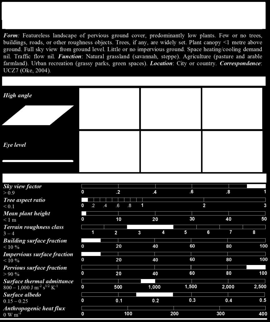
8 Local Climate Zones Standard Set

9 Observational support for LCZs Evening temperatures in Vancouver 2010 March 3 March 5 March 8 Average Summary UHI datasets from Uppsala (1948, 1976), Nagano ( ), and Vancouver ( ). Observations support the hierarchical structure of the LCZ system. Each LCZ class has a unique thermal climate Departure from group mean (K) Temperature patterns are sensitive to surface relief, surface wetness, tree geometry, and weather. Stewart ID, Oke TR Preprints, 9 th Symposium on Urban Environment.
.")

10 Numerical modeling support for LCZs Computer simulated temperatures DTR wet DTR dry Summary S. Krayenhoff University of British Columbia Highly simplified approach (treed zones excluded). Urban-surface (TEB) and plant-soil (CAPS) schemes coupled with atmospheric boundary layer model. Simulated DTR varies with building height, packing, land cover, and surface wetness. Dry/natural zones more thermally responsive than wet/built-up zones Diurnal Temperature Range (K) See Krayenhoff et al., Preprints, 8 th Symposium on the Urban Environment.


11 Application of local climate zones Quantifying UHI magnitude in Vancouver, CANADA Mapping urban terrain in Novi Sad, SERBIA Assessing social inequalities in Santiago, CHILE Classifying weather stations in HONG KONG Sites of LCZ testing / application


12 Quantifying UHI magnitude: VANCOUVER LCZ2 3 March :30 hr LCZ1 Investigators I. Stewart and T. Oke University of British Columbia Purpose To define and quantify UHI magnitude through inter-zone temperature differences (DT LCZ ). DT LCZ = 2 K DT LCZ = 6 K Results UHI magnitude (DT LCZ ) varies with differences in morphology and land cover between LCZ pairs. LCZ11 LCZ15 DT LCZ > 7 K for zones with large morphological differences; < 2 K for zones with small differences. Stewart ID, Oke TR Preprints, 9 th Symposium on Urban Environment.


13 Classifying weather stations: HONG KONG Investigators C. Siu and M. Hart University of Hong Kong Purpose To classify HKO weather stations into LCZs, and identify representative sites for UHI measurement. Results Three of seventeen stations are representative of local scale. New standardized documentation system for station metadata. Challenges with LCZ system in Hong Kong. Siu C Unpublished MS Thesis, University of Hong Kong.


14 Mapping urban terrain: SERBIA Investigators J. Unger et al. University of Szeged / Novi Sad Purpose To map urban terrain and air temperature in Novi Sad using LCZs, and recommend strategic configuration for an urban climate network. Results Seven LCZs identified in Novi Sad urban area. Spatial correlation between LCZs and modeled air temperatures. Ten-station network recommended for UHI monitoring in Novi Sad. Unger J. et al. Article submitted to Advances in Meteorology.


15 Assessing social inequalities: CHILE Investigators H. Romero et al. Universidad de Chile Purpose To map LCZs in Santiago and assess the socio-economic status of district populations. Results LCZ morphology reflects thermal and social inequalities in Santiago. High-density districts: high temperatures, low-income populations. Romero H. et al Climate change and urban climate: Relations between thermal zones and the socioeconomic conditions of the population of Santiago, Chile. Revista INVI 70: Low-density districts: low temperatures, affluent populations.
16 Final Remarks What does the local climate zone system offer? The first comprehensive, climate-based classification of landscapes for heat island investigators. A user-friendly classification that transfers easily to any city, region, or culture. A standardized definition of UHI magnitude through climatologically defined urban and rural zones (DT LCZ ). An educational and analytical tool for students, researchers, and practitioners of urban climatology.
1.1 THERMAL DIFFERENTIATION OF LOCAL CLIMATE ZONES USING TEMPERATURE OBSERVATIONS FROM URBAN AND RURAL FIELD SITES
 1.1 THERMAL DIFFERENTIATION OF LOCAL CLIMATE ZONES USING TEMPERATURE OBSERVATIONS FROM URBAN AND RURAL FIELD SITES Iain Stewart,* Tim Oke University of British Columbia, Vancouver, Canada 1. PAST WORK:
A "Local Climate Zone" based approach to urban planning in Colombo, Sri Lanka
 A "Local Climate Zone" based approach to urban planning in Colombo, Sri Lanka N G R Perera 1 *, M P R Emmanuel 2 Department Of Architecture, University Of Moratuwa, Sri Lanka 1* nareinperera@gmail.com
Applying "Local Climate Zone (LCZ)" into a High-density High-rise Cities - A Pilot Study in Hong Kong
 into a High-density High-rise Cities - A Pilot Study in Hong Kong") Applying "Local Climate Zone (LCZ)" into a High-density High-rise Cities - A Pilot Study in Hong Kong Chao REN Yingsheng ZHENG 1, Chao REN 1,2 *, Yuan SHI 1, Kevin Ka-Lun LAU 1, Steve Hung Lam YIM 3,4,Derrick
Applying "Local Climate Zone (LCZ)" into a High-density High-rise Cities - A Pilot Study in Hong Kong Chao REN Yingsheng ZHENG 1, Chao REN 1,2 *, Yuan SHI 1, Kevin Ka-Lun LAU 1, Steve Hung Lam YIM 3,4,Derrick
DETERMINATION OF AN URBAN TEMPERATURE MONITORING NETWORK USING GIS METHODS
 DETERMINATION OF AN URBAN TEMPERATURE MONITORING NETWORK USING GIS METHODS LELOVICS 1 ENIKŐ, UNGER 1 J., GÁL 1 T. ABSTRACT. Determination of an urban temperature monitoring network using GIS methods. Local
5A.6 PRINCIPLE OF A SEMI-EMPIRICAL URBAN HEAT ISLAND MODELING USING CLIMATE CLASSIFICATION AND MOBILE MEASUREMENTS
 5A.6 PRINCIPLE OF A SEMI-EMPIRICAL URBAN HEAT ISLAND MODELING USING CLIMATE CLASSIFICATION AND MOBILE MEASUREMENTS François Leconte 1,2,3,*, Julien Bouyer 1,*, Rémy Claverie 1, Mathieu Pétrissans 3 1 Territorial
Determining the Optimal Grid Size of Local Climate Zones for Spatial Mapping in High-density Cities
 Determining the Optimal Grid Size of Local Climate Zones for Spatial Mapping in High-density Cities Kevin Ka-Lun Lau, Chao Ren, Yuan Shi, Venessa Zheng,, Hong Kong Background Urbanization results in distinctive
NEWLY DEVELOPED THERMAL CLIMATE ZONES FOR DEFINING AND MEASURING URBAN HEAT ISLAND MAGNITIDUE IN THE CANOPY LAYER
 J8.2A NEWLY DEVELOPED THERMAL CLIMATE ZONES FOR DEFINING AND MEASURING URBAN HEAT ISLAND MAGNITIDUE IN THE CANOPY LAYER Iain Stewart,* Tim Oke University of British Columbia, Vancouver, Canada 1. INTRODUCTION
Studying the Urban Heat Island Using a Local Climate Zone Scheme
 Pol. J. Environ. Stud. Vol. 25, No. 6 (2016), 2609-2616 DOI: 10.15244/pjoes/63672 Original Research Studying the Urban Heat Island Using a Local Climate Zone Scheme Zhihao Wang*, Wu Xing, Yi Huang, Tongan
The Road to Data in Baltimore
 Creating a parcel level database from high resolution imagery By Austin Troy and Weiqi Zhou University of Vermont, Rubenstein School of Natural Resources State and local planning agencies are increasingly
Quantifying the influence of wind advection on the urban heat island for an improvement of a climate change adaptation planning tool
 Quantifying the influence of wind advection on the urban heat island for an improvement of a climate change adaptation planning tool BEAR conference 15/12/2014 Bassett R., Cai X., Chapman L., Heaviside
330: Daytime urban heat island intensity in London during the winter season
 330: Daytime urban heat island intensity in London during the winter season Giridharan Renganathan Brunel University Abstract This paper will present results of the daytime urban heat island intensity
MODELING URBAN THERMAL ANISOTROPY
 MODELING URBAN THERMAL ANISOTROPY J. A. Voogt a, *, E. S. Krayenhoff a a Department of Geography, University of Western Ontario, London ON N6A 5C2 Canada -javoogt@uwo.ca KEY WORDS: surface temperature,
Urban-rural humidity and temperature differences in the Beijing area
 Theor Appl Climatol (9) 9:1 7 DOI 1.17/s7 ORIGINAL PAPER Urban-rural humidity and temperature differences in the Beijing area Weidong Liu & Huanling You & Junxia Dou Received: 5 June 7 /Accepted: 7 March
ScienceDirect. Local Climate Zone Study for Sustainable Megacities Development by Using Improved WUDAPT Methodology A Case Study in Guangzhou
 Available online at www.sciencedirect.com ScienceDirect Procedia Environmental Sciences 36 (2016 ) 82 89 International Conference on Geographies of Health and Living in Cities: Making Cities Healthy for
USING HYPERSPECTRAL IMAGERY
 USING HYPERSPECTRAL IMAGERY AND LIDAR DATA TO DETECT PLANT INVASIONS 2016 ESRI CANADA SCHOLARSHIP APPLICATION CURTIS CHANCE M.SC. CANDIDATE FACULTY OF FORESTRY UNIVERSITY OF BRITISH COLUMBIA CURTIS.CHANCE@ALUMNI.UBC.CA
Remote Sensing of Urban Surface Temperatures
 Remote Sensing of Urban Surface Temperatures James Voogt University of Western Ontario London, Ontario, Canada This work is supported by the Natural Sciences and Engineering Research Council of Canada.
9.1 The WUDAPT Project: Status of Database and Portal Tools
 9.1 The WUDAPT Project: Status of Database and Portal Tools G. Mills 1, B. Bechtel 2, M. Foley 1, Ching.J. 3, L See 4, J. Feddema 5 1 University College Dublin, Ireland, 2 University of Hamburg, Germany,
Labour Market Areas in Italy. Sandro Cruciani Istat, Italian National Statistical Institute Directorate for territorial and environmental statistics
 Labour Market Areas in Italy Sandro Cruciani Istat, Italian National Statistical Institute Directorate for territorial and environmental statistics Workshop on Developing European Labour Market Areas Nuremberg,
Outdoor human thermal comfort in local climate zones of Novi Sad (Serbia) during heat wave period
 during heat wave period") DOI: 10.15201/hungeobull.65.2.4 Milošević, D.D. et al. Hungarian Geographical Bulletin 65 (2016) 65 (2) (2) 129137. 129137. Outdoor human thermal comfort in local climate zones of Novi Sad (Serbia) during
DOI: 10.15201/hungeobull.65.2.4 Milošević, D.D. et al. Hungarian Geographical Bulletin 65 (2016) 65 (2) (2) 129137. 129137. Outdoor human thermal comfort in local climate zones of Novi Sad (Serbia) during
MESOSCALE MODELLING OVER AREAS CONTAINING HEAT ISLANDS. Marke Hongisto Finnish Meteorological Institute, P.O.Box 503, Helsinki
 MESOSCALE MODELLING OVER AREAS CONTAINING HEAT ISLANDS Marke Hongisto Finnish Meteorological Institute, P.O.Box 503, 00101 Helsinki INTRODUCTION Urban heat islands have been suspected as being partially
GEOGRAPHY (GE) Courses of Instruction
 Courses of Instruction") GEOGRAPHY (GE) GE 102. (3) World Regional Geography. The geographic method of inquiry is used to examine, describe, explain, and analyze the human and physical environments of the major regions of the
GEOGRAPHY (GE) GE 102. (3) World Regional Geography. The geographic method of inquiry is used to examine, describe, explain, and analyze the human and physical environments of the major regions of the
SPI: Standardized Precipitation Index
 PRODUCT FACT SHEET: SPI Africa Version 1 (May. 2013) SPI: Standardized Precipitation Index Type Temporal scale Spatial scale Geo. coverage Precipitation Monthly Data dependent Africa (for a range of accumulation
How Researchers Measure Urban Heat Islands. James Voogt Department of Geography, University of Western Ontario London ON Canada
 How Researchers Measure Urban Heat Islands James Voogt Department of Geography, University of Western Ontario London ON Canada Outline What is the urban heat island? What types of urban heat islands exist?
Building Energy Demand under Urban Climate and Climate Change conditions with consideration of Urban Morphology and Building Typology
 Building Energy Demand under Urban Climate and Climate Change conditions with consideration of Urban Morphology and Building Typology - GIS Mapping of the City of Stuttgart Limei Ji Fazia Ali-Toudert 1,
9th International Conference on Urban Climate 12th Symposium on the Urban Environment
 9th International Conference on Urban Climate 12th Symposium on the Urban Environment 20-24 July 2015, Toulouse, France Estimation of spatial air temperature distribution at sub-mesoclimatic scale using
Urban heat island effects over Torino
 3 Working Group on Physical Aspects: Soil and Surface 3 Urban heat island effects over Torino M. Milelli 1 1 ARPA Piemonte 1 Introduction Figure 1: Urban heat island generalized scheme (source: EPA). The
STUDY ON RELATIONSHIP BETWEEN CATCHMENT AND BUILT ENVIRONMENT OF METRO STATIONS IN HONG KONG AND SHENZHEN. Yin Ziyuan
 STUDY ON RELATIONSHIP BETWEEN CATCHMENT AND BUILT ENVIRONMENT OF METRO STATIONS IN HONG KONG AND SHENZHEN Yin Ziyuan DOCTOR OF PHILOSOPHY CITY UNIVERSITY OF HONG KONG JUNE 2014 CITY UNIVERSITY OF HONG
Level 2 Geography, 2014
 91240 912400 2SUPERVISOR S Level 2 Geography, 2014 91240 Demonstrate geographic understanding of a large natural environment 2.00 pm Monday 10 November 2014 Credits: Four Achievement Achievement with Merit
Grade 9 Social Studies Canadian Identity. Chapter 3 Review Canada s People. Chapter 3: Canada s People
 Grade 9 Social Studies Canadian Identity Chapter 3 Review Canada s People Chapter 3: Canada s People Terms (notes or textbook) Population Distribution Site Factors Seigneurial system Corridors Urbanization
Mutah university faculty of Social Sciences The Study plan of the department of Geography 2006/2007
 Mutah university faculty of Social Sciences The Study plan of the department of Geography 2006/2007 Requirements university compulsory 22 Credit hours Course No Credit hours Prerequisite Requirements Faculty
Level 2 Geography, 2013
 91240 912400 2SUPERVISOR S Level 2 Geography, 2013 91240 Demonstrate geographic understanding of a large natural environment 9.30 am Thursday 21 November 2013 Credits: Four Achievement Achievement with
GGY 301: Research Methods
 GGY 301: Research Methods Course No GGY 301 Course Title Research Methods Core/Optional Core for Special Degree :This course provides students with a basic knowledge and understanding of the research methodology
Modelling the Atmospheric Urban Heat Island and its Contributing Spatial Characteristics
 the Atmospheric Urban Heat Island and its Contributing Characteristics The Case of The Hague, the Netherlands Anna-Maria Ntarladima 07/11/2016 Urban Heat Island (UHI) is a phenomenon in which a city forms
PÀ ÁðlPÀ gádå G À Áå ÀPÀgÀ CºÀðvÁ ÀjÃPÉë KARNATAKA STATE ELIGIBILITY TEST FOR LECTUERSHIP
 PÀ ÁðlPÀ gádå G À Áå ÀPÀgÀ CºÀðvÁ ÀjÃPÉë KARNATAKA STATE ELIGIBILITY TEST FOR LECTUERSHIP Subject: GEOGRAPHY Subject Code: 08 Note: There will be two question papers, Paper-II and Paper-III. Paper II will
MONITORING OF SURFACE WATER RESOURCES IN THE MINAB PLAIN BY USING THE STANDARDIZED PRECIPITATION INDEX (SPI) AND THE MARKOF CHAIN MODEL
 AND THE MARKOF CHAIN MODEL") MONITORING OF SURFACE WATER RESOURCES IN THE MINAB PLAIN BY USING THE STANDARDIZED PRECIPITATION INDEX (SPI) AND THE MARKOF CHAIN MODEL Bahari Meymandi.A Department of Hydraulic Structures, college of
MONITORING OF SURFACE WATER RESOURCES IN THE MINAB PLAIN BY USING THE STANDARDIZED PRECIPITATION INDEX (SPI) AND THE MARKOF CHAIN MODEL Bahari Meymandi.A Department of Hydraulic Structures, college of
Jun Tu. Department of Geography and Anthropology Kennesaw State University
 Examining Spatially Varying Relationships between Preterm Births and Ambient Air Pollution in Georgia using Geographically Weighted Logistic Regression Jun Tu Department of Geography and Anthropology Kennesaw
312/1 GEOGRAPHY PAPER 1 EMBU NORTH EVALUATION EXAM JULY /AUGUST 2018 TIME: 2HRS 45 MIN INSTRUCTIONS
 312/1 GEOGRAPHY PAPER 1 EMBU NORTH EVALUATION EXAM JULY /AUGUST 2018 TIME: 2HRS 45 MIN INSTRUCTIONS 1. Answer all questions in section A 2. In section B answer question 6 and any other two questions. 3.
Regional Climatology. Lab Number Two (10pts) Climatic Classification and Polar Climates
 Climatic Classification and Polar Climates") Name: Time of Class: Due Date: Regional Climatology Lab Number Two (10pts) Climatic Classification and Polar Climates Part I: Group Discussion and Answer Directions: Arrange a group of three individuals.
Name: Time of Class: Due Date: Regional Climatology Lab Number Two (10pts) Climatic Classification and Polar Climates Part I: Group Discussion and Answer Directions: Arrange a group of three individuals.
NCEP non-hydrostatic regional model and surface scheme LAPS: A dynamical scaling tool for use in agricultural models
 NCEP non-hydrostatic regional model and surface scheme LAPS: A dynamical scaling tool for use in agricultural models D.T. Mihailović and B. Lalić Faculty of Agriculture, University of Novi Sad, Novi Sad,
LAND USE MAPPING FOR CONSTRUCTION SITES
 LAND USE MAPPING FOR CONSTRUCTION SITES STATEMENT OF THE PROBLEM Monitoring of existing construction sites within the limits of the City of Columbia is a requirement of the city government for: 1) Control
Building a Vibrant and Enduring Spatial Science John P. Wilson IWGIS2014 Beijing, China
 Building a Vibrant and Enduring Spatial Science John P. Wilson IWGIS2014 Beijing, China Outline Spatial roots o Geography o Landscape architecture o Computer science The (current) opportunity Guiding principles
World Geography Unit Curriculum Document
 Unit Number and Title: Unit 9-Review (including a comparison to North America) Curriculum Concepts: Globalization Culture Democracy Diversity Migration Enduring Understandings (Big Ideas): Time Frame:
Graduate Courses Meteorology / Atmospheric Science UNC Charlotte
 Graduate Courses Meteorology / Atmospheric Science UNC Charlotte In order to inform prospective M.S. Earth Science students as to what graduate-level courses are offered across the broad disciplines of
DEPARTMENT OF GEOGRAPHY B.A. PROGRAMME COURSE DESCRIPTION
 DEPARTMENT OF GEOGRAPHY B.A. PROGRAMME COURSE DESCRIPTION (3 Cr. Hrs) (2340100) Geography of Jordan (University Requirement) This Course pursues the following objectives: - The study the physical geographical
G E O G RAP H Y Geomorphology: Climatology : Oceanography: Geographic Thought : Population Geography :
 GEOGRAPHY SYALLABUS Geomorphology: Fundamental concepts; Endogenetic and Exogenetic forces; Denudation and weathering; Geosynclines, continental drift and plate tectonics; Concept of geomorphic cycle;
URBAN CHANGE DETECTION OF LAHORE (PAKISTAN) USING A TIME SERIES OF SATELLITE IMAGES SINCE 1972
 USING A TIME SERIES OF SATELLITE IMAGES SINCE 1972") URBAN CHANGE DETECTION OF LAHORE (PAKISTAN) USING A TIME SERIES OF SATELLITE IMAGES SINCE 1972 Omar Riaz Department of Earth Sciences, University of Sargodha, Sargodha, PAKISTAN. omarriazpk@gmail.com ABSTRACT
URBAN CHANGE DETECTION OF LAHORE (PAKISTAN) USING A TIME SERIES OF SATELLITE IMAGES SINCE 1972 Omar Riaz Department of Earth Sciences, University of Sargodha, Sargodha, PAKISTAN. omarriazpk@gmail.com ABSTRACT
What is Climate? Understanding and predicting climatic changes are the basic goals of climatology.
 What is Climate? Understanding and predicting climatic changes are the basic goals of climatology. Climatology is the study of Earth s climate and the factors that affect past, present, and future climatic
Geostatistical Analysis of Rainfall Temperature and Evaporation Data of Owerri for Ten Years
 Atmospheric and Climate Sciences, 2012, 2, 196-205 http://dx.doi.org/10.4236/acs.2012.22020 Published Online April 2012 (http://www.scirp.org/journal/acs) Geostatistical Analysis of Rainfall Temperature
Research Article A Quantitative Assessment of Surface Urban Heat Islands Using Satellite Multitemporal Data over Abeokuta, Nigeria
 International Atmospheric Sciences Volume 2016, Article ID 3170789, 6 pages http://dx.doi.org/10.1155/2016/3170789 Research Article A Quantitative Assessment of Surface Urban Heat Islands Using Satellite
The Atmospheric Boundary Layer. The Surface Energy Balance (9.2)
") The Atmospheric Boundary Layer Turbulence (9.1) The Surface Energy Balance (9.2) Vertical Structure (9.3) Evolution (9.4) Special Effects (9.5) The Boundary Layer in Context (9.6) Atm S 547 Lecture 4,
The Atmospheric Boundary Layer Turbulence (9.1) The Surface Energy Balance (9.2) Vertical Structure (9.3) Evolution (9.4) Special Effects (9.5) The Boundary Layer in Context (9.6) Atm S 547 Lecture 4,
Urban Studies Applicable to students admitted in
 Urban Studies Applicable to students admitted in 2014-15 Major Programme Requirement Students are required to complete a minimum of 8 units of courses as follows: 1. Faculty Package: 9 Any three courses,
2016 Irrigated Crop Production Update
 2016 Irrigated Crop Production Update Mapping Climate Trends and Weather Extremes Across Alberta for the Period 1950-2010 Stefan W. Kienzle Department of Geography University of Lethbridge, Alberta, Canada
Exploiting Earth Observation data products for mapping Local Climate Zones
 Exploiting Earth Observation data products for mapping Local Climate Zones Zina Mitraka 1,3, Nektarios Chrysoulakis 1, Jean Philippe Gastellu-Etchegorry 2, Fabio Del Frate 3,4 1 Foundation for Research
Future Cities and Environment
 Bourikas et al. Future Cities and Environment (2016) 2:7 DOI 10.1186/s40984-016-0020-4 Future Cities and Environment TECHNICAL ARTICLE Transforming typical hourly simulation weather data files to represent
Representivity of wind measurements for design wind speed estimations
 Representivity of wind measurements for design wind speed estimations Adam Goliger 1, Andries Kruger 2 and Johan Retief 3 1 Built Environment, Council for Scientific and Industrial Research, South Africa.
Lancaster Environment Centre, Lancaster University, Lancaster, LA1 4YQ, UK;
 Title Page Dynamics and controls of urban heat sink and island phenomena in a desert city: development of a local climate zone scheme using remotely-sensed inputs Ahmed K. NASSAR (corresponding author)
Short Communication Urban and rural temperature trends in proximity to large US cities:
 INTERNATIONAL JOURNAL OF CLIMATOLOGY Int. J. Climatol. 27: 1801 1807 (2007) Published online 7 September 2007 in Wiley InterScience (www.interscience.wiley.com).1555 Short Communication Urban and rural
research highlight Wind-Rain Relationships in Southwestern British Columbia Introduction Methodology Figure 2 Lower Mainland meteorological stations
 research highlight June 2007 Technical Series 07-114 Introduction Building envelope failures in southwestern British Columbia has brought to light the strong influence of wind-driven rain on building envelopes.
Curriculum Links AS and A level Field Studies
 Equipment Includes Human Geography Coastal Management Students examine the conflicts that arise from coastal erosion and the options for coastal management. They investigate different types of coastal
Curriculum map GEOGRAPHY
 Curriculum map Learning outcomes (LOs): Having completed a major in Geography, a student will be able to: 1. Demonstrate an understanding of the major biophysical and social patterns in the world, and
Display and analysis of weather data from NCDC using ArcGIS
 Display and analysis of weather data from NCDC using ArcGIS Helen M. Cox Associate Professor Geography Department California State University, Northridge and Stephen Krug Graduate Student Geography Department
EXPLORING THE URBAN HEAT ISLAND INTENSITY OF DUTCH CITIES
 EXPLORING THE URBAN HEAT ISLAND INTENSITY OF DUTCH CITIES L.W.A. van Hove 1,2, C.M.J. Jacobs 3, B.G. Heusinkveld 1, J.A. Elbers 3, G.J. Steeneveld 1, S. Koopmans 1, E.J. Moors 3, A.A.M. Holtslag 1 1 Wageningen
SENSITIVITY OF THE SURFEX LAND SURFACE MODEL TO FORCING SETTINGS IN URBAN CLIMATE MODELLING
 SENSITIVITY OF THE SURFEX LAND SURFACE MODEL TO FORCING SETTINGS IN URBAN CLIMATE MODELLING Gabriella Zsebeházi PhD supervisor: Gabriella Szépszó Regional Climate Modelling Group, Hungarian Meteorological
Treatment of Land-Use and Urbanization
 Treatment of Land-Use and Urbanization LECTURE 9 Alexander Mahura Danish Meteorological Institute, DMI, Copenhagen, Denmark NetFAM Summer School on Integrated Modelling 7-12 July 2008, Zelenogorsk, Russia
West meets East: Monitoring and modeling urbanization in China Land Cover-Land Use Change Program Science Team Meeting April 3, 2012
 West meets East: Monitoring and modeling urbanization in China Land Cover-Land Use Change Program Science Team Meeting April 3, 2012 Annemarie Schneider Center for Sustainability and the Global Environment,
Seasonal dependence of the urban heat island on the street canyon aspect ratio
 QuarterlyJournalof theroyalmeteorologicalsociety Q. J. R. Meteorol. Soc. 140: 2197 2210, October 2014 A DOI:10.1002/qj.2289 Seasonal dependence of the urban heat island on the street canyon aspect ratio
Pathways. Pathways through the Geography Major
 Pathways through the Major majors may structure their course selections around a sub-field of. Pathways are suggestions for classes in, in related disciplines, and skills training. Each pathway includes
Challenges Associated with Classifying Urban Meteorological Stations: The Oklahoma City Micronet Example
 88 The Open Atmospheric Science Journal, 2010, 4, 88-100 Open Access Challenges Associated with Classifying Urban Meteorological Stations: The Oklahoma City Micronet Example Amanda J. Schroeder *, Jeffrey
EXAMINATIONS ON THE ROLE OF SYNOPTIC CONDITIONS IN URBAN HEAT ISLAND DEVELOPMENT IN DEBRECEN
 EXAMINATIONS ON THE ROLE OF SYNOPTIC CONDITIONS IN URBAN HEAT ISLAND DEVELOPMENT IN DEBRECEN Sándor SZEGEDI, Tamás TÓTH, István LÁZÁR, Elemér LÁSZLÓ Department of Meteorology, University of Debrecen, Hungary
ANALYSIS OF URBAN LOCAL CLIMATE USING IN-SITU MEASUREMENTS
 ANALYSIS OF URBAN LOCAL CLIMATE USING IN-SITU MEASUREMENTS CSENGE DIAN 1, RITA PONGRÁCZ 1, JUDIT BARTHOLY 1, ZSUZSANNA DEZSŐ 1 ABSTRACT. - Analysis of Urban Local Climate Using In-Situ Measurements Concentrated
An Analysis of Urban Cooling Island (UCI) Effects by Water Spaces Applying UCI Indices
 Effects by Water Spaces Applying UCI Indices") An Analysis of Urban Cooling Island (UCI) Effects by Water Spaces Applying UCI Indices D. Lee, K. Oh, and J. Seo Abstract An urban cooling island (UCI) involves an area that has a lower temperature compared
An Analysis of Urban Cooling Island (UCI) Effects by Water Spaces Applying UCI Indices D. Lee, K. Oh, and J. Seo Abstract An urban cooling island (UCI) involves an area that has a lower temperature compared
Desert Museum Trip. Urban Ecology. Saturday Nov 4 th 10 AM COS funds for admission and lunch w/ TRAD: Origins of Human Diversity
 Desert Museum Trip Saturday Nov 4 th 10 AM COS funds for admission and lunch w/ TRAD: Origins of Human Diversity Tuesdays 7PM (Oct 17) UA Centennial Hall http://cos.arizona.edu/climate/ Urban Ecology I.
Meteorology. Chapter 15 Worksheet 1
 Chapter 15 Worksheet 1 Meteorology Name: Circle the letter that corresponds to the correct answer 1) The Tropic of Cancer and the Arctic Circle are examples of locations determined by: a) measuring systems.
Subtropical Urban Heat Island Development and Estimation Around Taipei City, Taiwan
 1 Subtropical Urban Heat Island Development and Estimation Around Taipei City, Taiwan WEN-ZER LIN a,*, HSIAO-CHUNG TSAI b, CHUNG-HO WANG c, CHIA CHOU a a Research Center for Environmental Changes, Academia
An uncoupled pavement-urban canyon model for heat islands
 An uncoupled pavement-urban canyon model for heat islands Sushobhan Sen & Jeffery Roesler University of Illinois at Urbana-Champaign Pavement Life Cycle Assessment Symposium 2017 University of Illinois
URBAN LAND COVER AND LAND USE CLASSIFICATION USING HIGH SPATIAL RESOLUTION IMAGES AND SPATIAL METRICS
 URBAN LAND COVER AND LAND USE CLASSIFICATION USING HIGH SPATIAL RESOLUTION IMAGES AND SPATIAL METRICS Ivan Lizarazo Universidad Distrital, Department of Cadastral Engineering, Bogota, Colombia; ilizarazo@udistrital.edu.co
DROUGHT RISK EVALUATION USING REMOTE SENSING AND GIS : A CASE STUDY IN LOP BURI PROVINCE
 DROUGHT RISK EVALUATION USING REMOTE SENSING AND GIS : A CASE STUDY IN LOP BURI PROVINCE K. Prathumchai, Kiyoshi Honda, Kaew Nualchawee Asian Centre for Research on Remote Sensing STAR Program, Asian Institute
Georeferencing and Satellite Image Support: Lessons learned, Challenges and Opportunities
 Georeferencing and Satellite Image Support: Lessons learned, Challenges and Opportunities Shirish Ravan shirish.ravan@unoosa.org UN-SPIDER United Nations Office for Outer Space Affairs (UNOOSA) UN-SPIDER
Agrometeorological activities in RHMSS
 Republic of Serbia Republic Hydrometeorological Service of Serbia Agrometeorological activities in RHMSS Department for applied climatology and agrometeorology www.hidmet.gov.rs Meteorological Observing
INVESTIGATING CLIMATES ON A LOCAL SCALE: URBAN CLIMATE IN MENDE
 INVESTIGATING CLIMATES ON A LOCAL SCALE: URBAN CLIMATE IN MENDE Discover Ltd. Timbers, Oxted Road, Godstone, SURREY. RH9 8AD www.discover.ltd.uk Discover Ltd 2009 1 INVESTIGATING CLIMATES ON A LOCAL SCALE:
Climate Roles of Land Surface
 Lecture 5: Land Surface and Cryosphere (Outline) Climate Roles Surface Energy Balance Surface Water Balance Sea Ice Land Ice (from Our Changing Planet) Surface Albedo Climate Roles of Land Surface greenhouse
Alleghany County Schools Curriculum Guide GRADE/COURSE: World Geography
 GRADE/COURSE: World 2013-14 GRADING PERIOD: 1 st Six Weeks Time Frame Unit/SOLs SOL # Strand Resource Assessment 8 days* The student will use maps, globes, satellite images, photographs, or diagrams to
Land cover research, applications and development needs in Slovakia
 Land cover research, applications and development needs in Slovakia Andrej Halabuk Institute of Landscape Ecology Slovak Academy of Sciences (ILE SAS) Štefánikova 3, 814 99 Bratislava, Slovakia Institute
Dynamical downscaling of future climate change scenarios in urban heat island and its neighborhood in a Brazilian subtropical area
 Dynamical downscaling of future climate change scenarios in urban heat island and its neighborhood in a Brazilian subtropical area Marcos Vinicius Bueno de Morais, Viviana Vanesa Urbina Guerrero, Leila
Coimisiún na Scrúduithe Stáit State Examinations Commission
 S28 Coimisiún na Scrúduithe Stáit State Examinations Commission JUNIOR CERTIFICATE EXAMINATION, 2003 GEOGRAPHY - HIGHER LEVEL MONDAY, 9 th JUNE - AFTERNOON, 1.30 TO 3.30 SECTION 2 (90 MARKS) Answer THREE
Contents Research Objects, Tasks and Historical Development of Tourism Earth-science Role of Tourism Earth-science in Tourism Development
 Contents 1 Research Objects, Tasks and Historical Development of Tourism Earth-science.... 1 1.1 Research Objects of Tourism Earth-science.... 1 1.1.1 Definition of Tourism Earth-science... 1 1.1.2 Definition
GEOGRAPHY ADVANCED LEVEL
 GEOGRAPHY ADVANCED LEVEL The syllabus is based on the belief that geography makes a valuable contribution to education. This partly derives from the nature of the questions which geographers raise and
INFLUENCE OF SEA SURFACE TEMPERATURE ON COASTAL URBAN AREA - CASE STUDY IN OSAKA BAY, JAPAN -
 Proceedings of the Sixth International Conference on Asian and Pacific Coasts (APAC 2011) December 14 16, 2011, Hong Kong, China INFLUENCE OF SEA SURFACE TEMPERATURE ON COASTAL URBAN AREA - CASE STUDY
AERMOD Sensitivity to AERSURFACE Moisture Conditions and Temporal Resolution. Paper No Prepared By:
 AERMOD Sensitivity to AERSURFACE Moisture Conditions and Temporal Resolution Paper No. 33252 Prepared By: Anthony J Schroeder, CCM Managing Consultant TRINITY CONSULTANTS 7330 Woodland Drive Suite 225
Millennium Ecosystem Assessment
 Millennium Ecosystem Assessment Global Data Challenges from an MA perspective Global Spatial Data and Information User Workshop 21-23 September 2004! What is the MA?! How and what kinds of data does it
Most people used to live like this
 Urbanization Most people used to live like this Increasingly people live like this. For the first time in history, there are now more urban residents than rural residents. Land Cover & Land Use Land cover
Council Workshop on Neighbourhoods Thursday, October 4 th, :00 to 4:00 p.m. Burlington Performing Arts Centre
 Council Workshop on Neighbourhoods Thursday, October 4 th, 2012 1:00 to 4:00 p.m. Burlington Performing Arts Centre Agenda Introductions Warm-Up Exercise Presentation Exercise Neighbourhood Planning Break
First steps toward a comparison of modelled thermal comfort during a heatwave in Melbourne, Australia
 First steps toward a comparison of modelled thermal comfort during a heatwave in Melbourne, Australia Stephanie Jacobs PhD supervisors: Ailie Gallant and Nigel Tapper Outline of talk Motivation for research
COMPARISON OF PIXEL-BASED AND OBJECT-BASED CLASSIFICATION METHODS FOR SEPARATION OF CROP PATTERNS
 COMPARISON OF PIXEL-BASED AND OBJECT-BASED CLASSIFICATION METHODS FOR SEPARATION OF CROP PATTERNS Levent BAŞAYİĞİT, Rabia ERSAN Suleyman Demirel University, Agriculture Faculty, Soil Science and Plant
USING DOWNSCALED POPULATION IN LOCAL DATA GENERATION
 USING DOWNSCALED POPULATION IN LOCAL DATA GENERATION A COUNTRY-LEVEL EXAMINATION CONTENT Research Context and Approach. This part outlines the background to and methodology of the examination of downscaled
Research Article Modelling of the Annual Mean Urban Heat Island Pattern for Planning of Representative Urban Climate Station Network
 Advances in Meteorology Volume 2011, Article ID 398613, 9 pages doi:10.1155/2011/398613 Research Article Modelling of the Annual Mean Urban Heat Island Pattern for Planning of Representative Urban Climate
Modelling the Atmospheric Urban Heat Island and its Contributing Spatial Characteristics
 the Atmospheric Urban Heat Island and its Contributing Characteristics The Case of The Hague, the Netherlands Anna-Maria Ntarladima Alexander Wandl Hugo Ledoux 02/11/2016 Urban Heat Island (UHI) is a phenomenon
2012 Meteorology Summary
 212 Meteorology Summary New Jersey Department of Environmental Protection AIR POLLUTION AND METEOROLOGY Meteorology plays an important role in the distribution of pollution throughout the troposphere,
Advanced Placement Human Geography
 Advanced Placement Human Geography Introduction to AP Human Geography The Advanced Placement course in Human Geography is designed to introduce students to the systematic study of the processes that have
STAAR Vocabulary Words extracted directly from the standard and/or associated with the instruction of the content within the standard.
 STAAR Vocabulary Words extracted directly from the standard and/or associated with the instruction of the content within the standard. READINESS STANDARDS - World Geography (WG.1) History. The student