Town Planning Agency of Le Havre: The Industrial Network Tool, a decision support system that integrates energy, economy, logistics and environnement
|
|
|
- Augustus Gallagher
- 6 years ago
- Views:
Transcription

1 NA-5790/JD/JFlo - April 22nd, 2015 Town Planning Agency of Le Havre: The Industrial Network Tool, a decision support system that integrates energy, economy, logistics and environnement


2 AURH Town planning agency of Le Havre and Seine Estuary area Juliette DUSZYNSKI Project manager, in charge of economics, logistics, port and European projects AURH partners 2

 Launching Prospective")


3 INTRODUCTION Observing (the economy, real estate, population, housing market...) Launching Prospective Studies: Seine Axis, European project.. Town Planning and Geography Drawing up territorial projects, planning, local plans of town planning, master plans Conducting Specific Thematic Studies (urban policy, housing, commerce, urban transport...) 3
4 OUTLINE The Industrial Network Tool, a decision support system that integrates energy, economy, logistics and environnement 1 - The context, 2 - The philosophy of the project, 3 - How it is built & The use of GIS technology, 4 - The stakeholders and the results expected, 5 - Conclusion: How this approach and tool could be exported and replicated on other port cities 4

5 THE CONTEXT 5

6 THE RANGE NORD At the entree of the Northern European Range 6


7 THE SEINE GATEWAY The Seine River Estuary 2 big seaports: Le Havre & Rouen 472 towns and cities 614,500 inhabitants in
8 THE SEINE RIVER ESTUARY The Seine River Estuary 2 big seaports: Le Havre & Rouen 472 towns and cities 614,500 inhabitants in


")


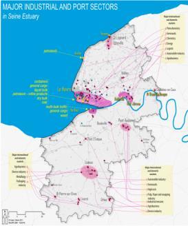
9 A POWERFUL INDUSTRIAL AND PORT COMPLEX An industrial know-how overview An industrial & logistic port area of approximately 6,000 ha (with the infrastructures network) Major international players A leading European chemical and petrochemical centre #1 and #2 French refineries Other main industrial activities Energy Industries, Waste treatment Industry, Aeronautic Industry, Pharmaceutical Industry, Plastic Processing, Mechanical Construction, Metallurgy Industry, Agro Industry,. 9
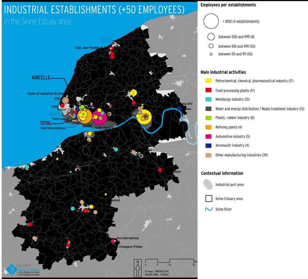
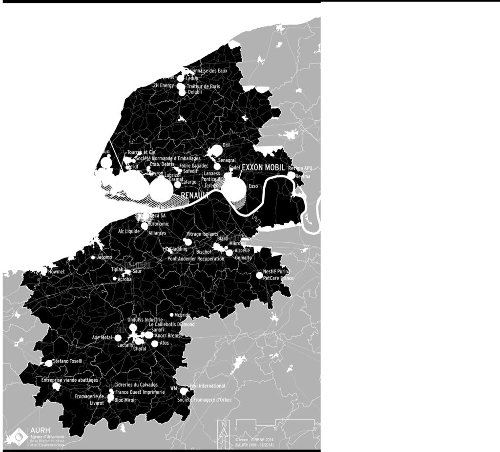
10 MAIN INDUSTRIAL ACTIVITIES 1


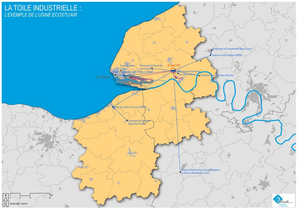
11 KEY FIGURES 38,800 jobs in Industrial Sectors, 2,050 industrial sites 9 jobs out of 10 in production 5,436 jobs in Chemical Industries 2,970 jobs in Refining & Coking Industries 2,381 employees in Rubber Manufacturing Land and Air Transport Storage and Related Services Source: INSEE - CLAP ,615 jobs in Transport and Supply chain sectors, including 1 out of 2 jobs in Storage and related services 11


12 PHILOSOPHY PROJECT Dunkirk Source: FNAU 12


13 International markets The Dunkirk Sea Port Industrial Network The Dunkirk Maritime Port Firms The Dunkirk area International markets Subcontractors


14 A DATABASED SOFTWARE THE INDUSTRIAL NETWORK A strategic tool promoting regional management A state of physical flows connecting businesses between themselves and the local network linking businesses to the ports and international markets Industrial facilities, Firms Material Links (goods, energy, raw materials) Cities, local authorities Entities Links Logistical Links Port terminals Contractual Links 14

15 THE INDUSTRIAL NETWORK TOOL: WHY DO WE NEED IT? Regional observation is our core job TO UNDERSTAND How our region is organised using industrial and corporate locations in our region existing or future relationships between the Seine River Estuary s industries as well as with international markets TO DESIGN A forward-looking tool to allow us to understand the situation as well as the industrial evolution in our territory a simulation of possible changes TO SHARE A same culture in-depth knowledge of the industrial fibre found in the Seine River Estuary sharing the same culture of our region s industrial ecosystem 15
16 INNOVATION: A NEW APPROACH TO INDUSTRIAL PORT REGIONS Theoretical innovation innovation Strategic stratégique innovation innovation Technical innovation technique Industrial regions and ports defined by their flows, creating an ecosystem A forward-looking tool for industrial intelligence A dynamic representation of the industrial port region of the Seine River Estuary Reconnecting ports, industries and regions Flows Added value Adaptation to economic changes, industrial structuring A territory that is able to propose and react From charts to mapping From maps to geo-maps (a conjunction of a map + a data base) 16


17 INNOVATION: A NEW APPROACH TO INDUSTRIAL PORT REGIONS Theoretical innovation International and domestic markets Industrial regions and ports defined by their flows, creating an ecosystem Reconnecting ports, Industries and regions Flows Added value International and domestic markets International and domestic markets 17
18 INNOVATION: A NEW APPROACH TO INDUSTRIAL PORT REGIONS Theoretical innovation innovation Strategic stratégique innovation innovation Technical innovation technique Industrial regions and ports defined by their flows, creating an ecosystem A forward-looking tool for industrial intelligence A dynamic representation of the industrial port region of the Seine River Estuary Reconnecting ports, industries and regions Flows Added value Adaptation to economic changes, industrial structuring A territory that is able to propose and react From charts to mapping From maps to geo-maps (a conjunction of a map + a data base) INNOVATION - CIRCULAR ECONOMY 18
19 OUTPUT INPUT Cities, local authorities Industrial firms Waste Raw materials Energy Waste recycling centres Energy Cleanouts Circular economy The Energy sector The Agro-industry sector 19


20 INNOVATION: A NEW APPROACH TO INDUSTRIAL PORT REGIONS From waste to steam: Tereos-Eco stuaire Heating network between an incineration plant and an agro-industrial plant From a 100% electricity production from the incineration plant to CHP production 3x more efficient in terms of energy Provide 2/3 of heat needs of the distillery plant Reduction ~ 7-8 / t of waste treated Total investment: 16 million in 2014 Grains Waste Waste incinerator A heat network Agro industry Bio ethanol Energy sector 20
21 INNOVATION: A NEW APPROACH TO INDUSTRIAL PORT REGIONS Theoretical innovation innovation Strategic stratégique innovation innovation Technical innovation technique Industrial regions and ports defined by their flows, creating an ecosystem A forward-looking tool for industrial intelligence A dynamic representation of the industrial port region of the Seine River Estuary Reconnecting ports, industries and regions Flows Added value Adaptation to economic changes, industrial structuring A territory that is able to propose and react From charts to mapping From maps to geo-maps (a conjunction of a map + a data base) 21
22 A TECHNICAL INNOVATION 22
23 A TECHNICAL INNOVATION 23
24 A TECHNICAL INNOVATION 24
25 A TECHNICAL INNOVATION 25

26 A TECHNICAL INNOVATION 26


27 INNOVATION: A NEW APPROACH TO INDUSTRIAL PORT REGIONS Theoretical innovations innovation Strategic innovations stratégique innovation Technical innovations technique Industrial regions and ports defined by their flows, creating an ecosystem A forward-looking tool for industrial intelligence A dynamic representation of the industrial port region of the Seine River Estuary 27
28 THE CONCEPT BEHIND THE INDUSTRIAL NETWORK TOOL Group Group Entity (x,y) Group Entity (x,y) Group Entity (x,y) Entity Group Link Attribute (typ, name, data) Document 28

29 AN RELATIONAL DATABASE MANAGEMENT SYSTEM IN POSTGRESQL 29

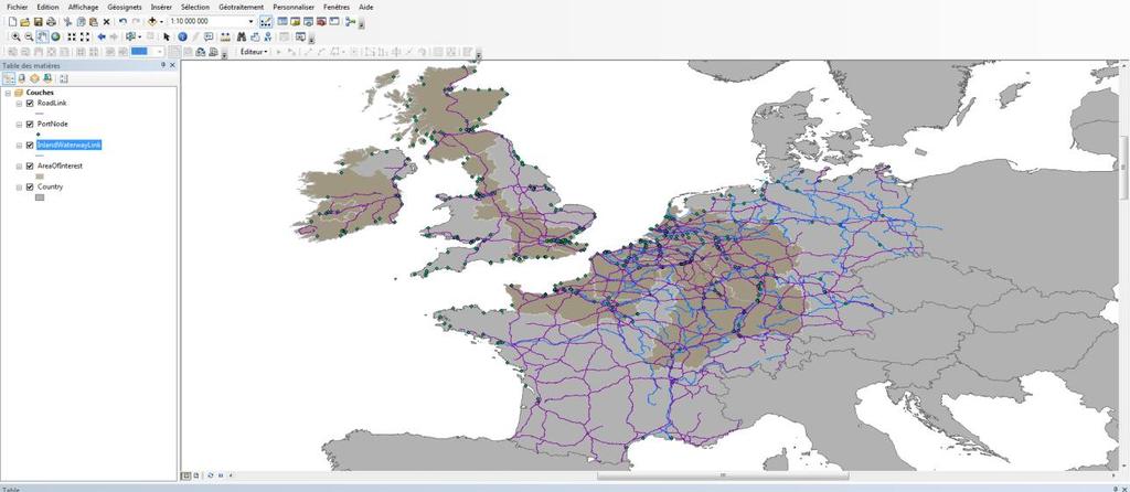
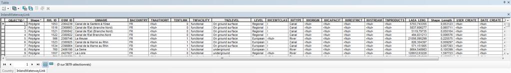


30 Layers GEOGRAPHICAL INFORMATION SYSTEM - GIS Informatic toolset to set-up, format and display the geographic information Data collection (real world) Zoom in/out (different scales) and layout Map Organization in layers of information The data are georeferenced Table of data Organization according attributes 30
31 OUTPUT INPUT Cities, local authorities Industrial firms Waste Raw materials Energy Waste recycling centres Energy Cleanouts Circular economy The Energy sector The Agro-industry sector 31
32 GRAPHIC VISUALIZATION 32
33 GIS VISUALIZATION 33


34 THE RESULTS EXPECTED A tool to serve our regions and stakeholders Our firms Our ports Our cities and territories 34


35 THE RESULTS EXPECTED: SOME KIND OF AN APP FOR THE TERRITORY Tablet Smartphone Computer 35

36 CONCLUSION This approach and this tool could be exported and replicated on other ports and other cities How? In using open source technologies In first creating a network of stakeholders, ambassadors and supporters of this tool 36

37 OPENING 37

38 OPENING 38
39 CONTACT AURH - Town Planning Agency of Le Havre and Seine Estuary Area Web Site: Juliette DUSZYNSKI Project Manager for Economy, Logistics, Ports and European Projects Mobile: Mail: j.duszynski@aurh.fr Julien FLORANT Research officier and GIS specialist Mail: j.florant@aurh.fr THANK YOU! 39
Compact guides GISCO. Geographic information system of the Commission
 Compact guides GISCO Geographic information system of the Commission What is GISCO? GISCO, the Geographic Information System of the COmmission, is a permanent service of Eurostat that fulfils the requirements
Belfairs Academy GEOGRAPHY Fundamentals Map
 YEAR 12 Fundamentals Unit 1 Contemporary Urban Places Urbanisation Urbanisation and its importance in human affairs. Global patterns of urbanisation since 1945. Urbanisation, suburbanisation, counter-urbanisation,
2 nd Semester. Core Courses. C 2.1 City and Metropolitan Planning. Module 1: Urban Structure and Growth Implications
 2 nd Semester Core Courses C 2.1 City and Metropolitan Planning Module 1: Urban Structure and Growth Implications Growth of cities; cities as engine of growth; urban sprawl; land value, economic attributes
Putting the U.S. Geospatial Services Industry On the Map
 Putting the U.S. Geospatial Services Industry On the Map December 2012 Definition of geospatial services and the focus of this economic study Geospatial services Geospatial services industry Allow consumers,
High speed network in Hauts-de-France Region. Värnamo, 17 th May 2018
 High speed network in Hauts-de-France Region Värnamo, 17 th May 2018 Hauts-de-France at the crossroads of the North-West Europe High speed train approach in France In the 1980s: will to link the main cities
Building the Sustainable Network of Settlements on the Caspian Sea Region of Kazakhstan
 Building the Sustainable Network of Settlements on the Caspian Sea Region of Kazakhstan Introduction The Ecological Zoning and Identification of Ecological Capacity of Natural and Socio- Economic Potential
ESPON 2020 Cooperation Programme. Anneloes van Noordt MC-member Belgium
 ESPON 2020 Cooperation Programme Anneloes van Noordt MC-member Belgium Anneloes.vannoordt@vlaanderen.be Outline ESPON 2020 Cooperation Programme Applied Research Targeted Analysis Database & Tools Outreach
Set-up of subnational statistical systems Statistical Development Strategy for the State of Jalisco México, 2016
 Set-up of subnational statistical systems Statistical Development Strategy for the State of Jalisco México, 2016 Statistical and Geographical Information Institute of Jalisco (IIEG) 2013. Merger of three
Nepal-China Economic Relationship: Learning and Unlearning from Chinese Model of Development
 1 WELCOME TO THE PRESENTATION ON Nepal-China Economic Relationship: Learning and Unlearning from Chinese Model of Development Pukar Lamichhane 2 Presentation Outline 1. Introduction 2. Overview of Chinese
CLLD Cooperation OFFER
 Title of the proposed project (English) CLLD Cooperation OFFER PARKS PROTECTION III - Management, Protection and Economic Development in Protected Areas Type of project (select as many as you want) Cooperation
THE ROLE OF REGIONAL SPATIAL PLANNING IN SUPPORTING LONG-TERM ECONOMIC GROWTH IN NORTHERN IRELAND
 THE ROLE OF REGIONAL SPATIAL PLANNING IN SUPPORTING LONG-TERM ECONOMIC GROWTH IN NORTHERN IRELAND Jenny Pyper Director 6 th Annual ICLRD Conference 20 January 2011 PURPOSE OF REGIONAL PLANNING Framework
Geographical Information Systems Energy Database Report. WP1 T1.3- Deliverable 1.9
 Geographical Information Systems Energy Database Report WP1 T1.3- Deliverable 1.9 March 2015 1 314164 (ENER/FP7/314164) Project acronym: InSMART Project full title: Integrative Smart City Planning Coordination
The Added Value of Geospatial Data in a Statistical Office. Pedro Diaz Munoz Director Sectoral and Regional Statistics EUROSTAT European Commission
 The Added Value of Geospatial Data in a Statistical Office Pedro Diaz Munoz Director Sectoral and Regional Statistics EUROSTAT European Commission Why integrate Responsibility of all the information we
Advancing Geoscientific Capability. Geological Survey of Finland
 Advancing Geoscientific Capability Geological Survey of Finland GTK in brief The Geological Survey of Finland (GTK) is one of the largest European centres of excellence in assessment, research and the
RUSSIAN CHEMICAL INDUSTRY
 RUSSIAN CHEMICAL INDUSTRY SHARE OF CHEMICAL PRODUCTS IN MANUFACTURING (% OF THE TOTAL VOLUME IN RUBLES)* INDEX OF CHEMICAL PRODUCTION BY VOLUME (% OF THE TOTAL VOLUME IN TONNES)* FIXED INVESTMENTS (% OF
Making space for a more foundational construction sector in Brussels
 Making space for a more foundational construction sector in Brussels Sarah De Boeck, David Bassens & Michael Ryckewaert Social innovation in the Foundational Economy Cardiff, 5 th of September 2018 1.
MEU A cartographic-based web-platform for urban energy management and planning
 MEU A cartographic-based web-platform for urban energy management and planning Massimiliano Capezzali 1, Gaëtan Cherix 2, 1 Energy Center, Ecole Polytechnique Fédérale de Lausanne (EPFL), 1015 Lausanne
Seaport Status, Access, and Regional Development in Indonesia
 Seaport Status, Access, and Regional Development in Indonesia Muhammad Halley Yudhistira Yusuf Sofiyandi Institute for Economic and Social Research (LPEM), Faculty of Economics and Business, University
Atlantic Area Programme. 4. Promote transnational synergies in sustainable urban and regional development
 2007-2013 Atlantic Area Programme Acronym: Title: ATBrand AT.Brand Project start date: 01/01/2014 Project end date: 30/06/2015 Project working Language: English Priority 4. Promote transnational synergies
Topic 4: Changing cities
 Topic 4: Changing cities Overview of urban patterns and processes 4.1 Urbanisation is a global process a. Contrasting trends in urbanisation over the last 50 years in different parts of the world (developed,
The Integrated Ge spatial Information Framework to the strengthening of NSDI, Mongolia
 Young Geospatial Professionals Summit 21 NOV 2018 The Integrated Ge spatial Information Framework to the strengthening of NSDI, Mongolia BAYARMAA ENKHTUR Geospatial information and technology department
On transport and other infrastructure knitting regions together
 Published as: WITLOX, F. (2011) On transport and other infrastructure knitting regions together. In: A. VAN RENTERGHEM (Ed.) Polycentric Regions facing Global Challenges. A Role for Strategic Spatial Planning
INSPIRE Basics. Vlado Cetl European Commission Joint Research Centre. https://ec.europa.eu/jrc/
 INSPIRE Basics Vlado Cetl European Commission Joint Research Centre https://ec.europa.eu/jrc/ Serving society Stimulating innovation Supporting legislation Outline SDI? Why European SDI? INSPIRE Policy
Implementation of the ESPON 2020 cooperation program. 16 January 2017 Anneloes van Noordt
 Implementation of the ESPON 2020 cooperation program 16 January 2017 Anneloes van Noordt Outline! ESPON Cooperation Program! Specific Objectives! Applied Research! Targeted Analysis! Database & Tools!
Land Use in the context of sustainable, smart and inclusive growth
 Land Use in the context of sustainable, smart and inclusive growth François Salgé Ministry of sustainable development France facilitator EUROGI vice president AFIGéO board member 1 Introduction e-content+
Business Model for sustainable regional development by tourism
 Business Model for sustainable regional development by tourism Why EuroVeloPark Banat? Steps to Success Action proposal 1. Drawing of the Basis Map 2. Data Acquisition, POIs, etc. 3. Printed Map and Distribution
Institute of Statistical and Geographical Information of Jalisco State Subnational Statistical and Geographical System India.
 Institute of Statistical and Geographical Information of Jalisco State Subnational Statistical and Geographical System India. January 2017 Subnational Statistical and Geographical System National Statistical
An online data and consulting resource of THE UNIVERSITY OF TOLEDO THE JACK FORD URBAN AFFAIRS CENTER
 An online data and consulting resource of THE JACK FORD URBAN AFFAIRS CENTER THE CENTER FOR GEOGRAPHIC INFORMATION SCIENCE AND APPLIED GEOGRAPHICS DEPARTMENT OF GEOGRAPHY AND PLANNING THE UNIVERSITY OF
Second High Level Forum on GGIM Seminar on Regional Cooperation in Geospatial Information Management Doha, Qatar, 7 February 2013
 Second High Level Forum on GGIM Seminar on Regional Cooperation in Geospatial Information Management Doha, Qatar, 7 February 2013 Overview on Geospatial Activities in Egypt BY : Eng.Nahla Seddik Mohamed
June 19 Huntsville, Alabama 1
 June 19 Huntsville, Alabama 1 Real-Time Geospatial Data: The Fusion of PI and ArcGIS Enabling Smarter Facilities Management OSIsoft and Esri Mapping and Location Analytics Platform Supporting Your Use
ALTER ECO Alternative tourist strategies to enhance the local sustainable development of tourism by promoting Mediterranean identity Module 2: Testing
 ALTER ECO Alternative tourist strategies to enhance the local sustainable development of tourism by promoting Mediterranean identity Module 2: Testing WHY? Areas of high tourism attraction in coastal cities
Department of Geography: Vivekananda College for Women. Barisha, Kolkata-8. Syllabus of Post graduate Course in Geography
 India: Regional Problems and Resource management Module 11 (Full Marks 50) Unit I: Region and Regionalisation 1.1 Various bases of regionalisation of India; problems of identification and delineation.
Central Baltic Programme
 Central Baltic Programme 2014-2020 About the Central Baltic Programme 2014-2020 Builds on the Central Baltic INTERREG IV A Programme 2007-2013 Cross-border cooperation projects in the central Baltic Sea
DETERMINE OF REGIONAL DEVELOPMENT STRATEGIES IN IZMIR
 Sukran Yalpir Asli Bozdag Saban Inam DETERMINE OF REGIONAL DEVELOPMENT STRATEGIES IN IZMIR Globalization INTRODUCTION Economic pressure cause Economic migration cause cause Spatial organizations Spatial
TOWARDS STRATEGIC SPATIAL PLANNING IN JAMAICA: THE NATIONAL SPATIAL PLAN
 TOWARDS STRATEGIC SPATIAL PLANNING IN JAMAICA: THE NATIONAL SPATIAL PLAN JIEP 5th Biennial Conference on the Environment: Balancing National Development and Environmental Protection June 6, 2011 Jamaica
Urbanization and Sustainable Development of Cities: A Ready Engine to Promote Economic Growth and Cooperation
 Urbanization and Sustainable Development of Cities: A Ready Engine to Promote Economic Growth and Cooperation Wan Portia Hamzah Institute of Strategic and International Studies (ISIS) Malaysia 10 September
STUDY GUIDE. Exploring Geography. Chapter 1, Section 1. Terms to Know DRAWING FROM EXPERIENCE ORGANIZING YOUR THOUGHTS
 For use with textbook pages 19 22. Exploring Geography Terms to Know location A specific place on the earth (page 20) absolute location The exact spot at which a place is found on the globe (page 20) hemisphere
Malaysia. Country Report. Oil and Gas Database Management. April 1-3, 2009
 April 1-3, 2009 Malaysia Country Report Oil and Gas Database Management The Legislative Framework of the Malaysian Petroleum Industry Relationship between the Government, PETRONAS and PSC Contractors Objectives
Urban innovation eco-systems: a possible toolbox
 Urban innovation eco-systems: a possible toolbox Marika Macchi Research Fellow (DISEI, University of Florence) marika.macchi@unifi.it 18-19 Septembre, 2017 Workshop in Lisbon Prof. Camilla Perrone (Lab
The National Spatial Strategy
 Purpose of this Consultation Paper This paper seeks the views of a wide range of bodies, interests and members of the public on the issues which the National Spatial Strategy should address. These views
EUSAIR on sea topics from Slovenian perspective
 MINISTRY OF FOREIGN AFFAIRS REPUBLIC OF SLOVENIA EUSAIR on sea topics from Slovenian perspective Mag. Andreja Jerina National Coordinator 4 EU MRS: 270 millions of population 19 MS 12 non MS Sea basin
Spatial information in strategic city planning - Zagreb experience. Darko Šiško City office for strategic planning, Zagreb
 Spatial information in strategic city planning - Zagreb experience Darko Šiško City office for strategic planning, Zagreb Overview Strategic city planning GI tools and trends Spatial data for strategic
Spatial Data Availability Energizes Florida s Citizens
 NASCIO 2016 Recognition Awards Nomination Spatial Data Availability Energizes Florida s Citizens State of Florida Agency for State Technology & Department of Environmental Protection Category: ICT Innovations
Spatial Planning & Climate Change
 Spatial Planning & Climate Change A GRIP Approach Joseph Scott, Glasgow & Clyde Valley Strategic Development Plan Authority, Scotland Today s presentation Context Spatial Planning & Climate Change Exploring
Experience and perspectives of using EU funds and other funding for the implementation of district renovation projects
 Experience and perspectives of using EU funds and other funding for the implementation of district renovation projects Ministry of the Interior of Lithuania Regional policy department Administration, coordination,
Oman NSDI Supporting Economic Development. Saud Al-Nofli Director of Spatial Data Directorate General of NSDI, NCSI
 Oman NSDI Supporting Economic Development 2017 Saud Al-Nofli Director of Spatial Data Directorate General of NSDI, NCSI "It s critical to make correct decisions the first time to optimize the Investments
Dr.Sinisa Vukicevic Dr. Robert Summers
 Dr.Sinisa Vukicevic Dr. Robert Summers "Planning" means the scientific, aesthetic, and orderly disposition of land, resources, facilities and services with a view to securing the physical, economic and
GIS Geographical Information Systems. GIS Management
 GIS Geographical Information Systems GIS Management Difficulties on establishing a GIS Funding GIS Determining Project Standards Data Gathering Map Development Recruiting GIS Professionals Educating Staff
FINLAND, A COOL ARCTIC COUNTRY WITH SNOW-HOW
 FINLAND, A COOL ARCTIC COUNTRY WITH SNOW-HOW To succeed in a constantly changing world, you have to change as well. Finland has reinvented itself in just one short century and we re still at it. Our national
Egypt Public DSS. the right of access to information. Mohamed Ramadan, Ph.D. [R&D Advisor to the president of CAPMAS]
![Egypt Public DSS. the right of access to information. Mohamed Ramadan, Ph.D. [R&D Advisor to the president of CAPMAS]](/thumbs/89/98483713.jpg "Egypt Public DSS. the right of access to information. Mohamed Ramadan, Ph.D. [R&D Advisor to the president of CAPMAS]") Egypt Public DSS ì the right of access to information Central Agency for Public Mobilization and Statistics Arab Republic of Egypt Mohamed Ramadan, Ph.D. [R&D Advisor to the president of CAPMAS] Egypt
Egypt Public DSS ì the right of access to information Central Agency for Public Mobilization and Statistics Arab Republic of Egypt Mohamed Ramadan, Ph.D. [R&D Advisor to the president of CAPMAS] Egypt
ASEV - Partner presentation
 ASEV - Partner presentation Lorenzo Sabatini Head of RTD project area l.sabatini@asev.it 20th-21st February, 2017 Kickoff meeting - Porto About ASEV ASEV - Agenzia per lo Sviluppo Empolese Valdelsa Spa
Capital, Institutions and Urban Growth Systems
 Capital, Institutions and Urban Growth Systems Robert Huggins Centre for Economic Geography, School of Planning and Geography, Cardiff University Divergent Cities Conference, University of Cambridge, Cambridge
Towards a City Model for Heritage-Led Regeneration and Tourism Development
 Towards a City Model for Heritage-Led Regeneration and Tourism Development Brian Smith, Secretary General European Association of Historic Towns and Regions Summary of Presentation Objective Background
Land Board, NW Services and SDI Tambet Tiits, FRICS
 Land Board, NW Services and SDI Tambet Tiits, FRICS 07.09.2016 200th anniversary of the Struve Geodetic Arc Friedrich Georg Wilhelm Struve and Carl Friedrich Tenner Struve Geodetic Arc The Struve Geodetic
Strengthening the cooperation in the region: Carpathian, Tisa,, Danube and Black Sea areas
 Strengthening the cooperation in the region: Carpathian, Tisa,, Danube and Black Sea areas 14th October 2009 SEE Annual Conference Advancing development through transnational cooperation in South East
CCDR-N A SMART INSTITUTION
 CCDR-N A SMART INSTITUTION A SMART LOCATION (Spain) Galicia NORTH Center (Spain) Castile-Leon Lorem ipsum dolor sit amet, consectetuer adipiscing elit. Morbi commodo, ipsum sed pharetra gravida. CCDR-N
EA SEA-WAY Project. 7 th Coordination Meeting. WP5 Development of sustainable passenger transport models for the Adriatic basin and capacity building
 EA SEA-WAY Project 7 th Coordination Meeting WP5 Development of sustainable passenger transport models for the Adriatic basin and capacity building 3 rd Cross Border Board Ravenna, January 26, 2016 The
The Analysis of Economic Development and Resilience Dynamics of Medium-Sized Towns
 Master Thesis Student: Ksenija Banovac Thesis supervisor: prof. Abdelillah Hamdouch, University François Rabelais, Tours The Analysis of Economic Development and Resilience Dynamics of Medium-Sized Towns
Analysis of Rural-Urban Systems and Historic Climate Data in Mexico
 Analysis of Rural-Urban Systems and Historic Climate Data in Mexico Global Conference on Big Data for Official Statistics October 2015, Abu Dhabi, UAE RURAL-URBAN SYSTEMS Rural-Urban Systems: Functional
6 th GLOBAL SUMMIT ON URBAN TOURISM 4 6 December 2017, Kuala Lumpur (Malaysia)
") 6 th GLOBAL SUMMIT ON URBAN TOURISM 4 6 December 2017, Kuala Lumpur (Malaysia) SUMMARY/CONCLUSIONS Esencan TERZIBASOGLU Director Destination Management and Quality eterzibasoglu@unwto.org 6TH GLOBAL SUMMIT
6 th GLOBAL SUMMIT ON URBAN TOURISM 4 6 December 2017, Kuala Lumpur (Malaysia) SUMMARY/CONCLUSIONS Esencan TERZIBASOGLU Director Destination Management and Quality eterzibasoglu@unwto.org 6TH GLOBAL SUMMIT
Voices from Private Sector: Insights for Future NSDI Development in Indonesia
 Voices from Private Sector: Insights for Future NSDI Development in Indonesia Ta n d a n g Yu l i a d i D w i P u t ra, Ryosuke S h i b a s a k i I n st i t u t e o f I n d u st r i a l S c i e n c e,
Low Density Areas : Places of Opportunity. Enrique Garcilazo, OECD Directorate for Public Governance and Territorial Development
 Low Density Areas : Places of Opportunity Enrique Garcilazo, OECD Directorate for Public Governance and Territorial Development Open Days, Brussels, 11 th October, 2016 Outline 1. Performance low density
2 nd EUROGI imagine Conference 2014 GI - Expertise Made in Europe 8 & 9 October 2014 in Berlin, Germany
 GEO-INFORMATION FOR JOB CREATION AND ECONOMIC GROWTH Conference block organised by the French Umbrella Association for Geospatial Information Moderator: Rapporteur: François Salgé AFIGéO Executive committee
The Socio Economic Development of the Marine Sector in the Atlantic Area. Stephen Hynes
 The Socio Economic Development of the Marine Sector in the Atlantic Area Stephen Hynes Overview SEMRU and its role in Marine Socioeconomic analysis Defining Ocean and Coastal Economies in the Atlantic
Innovation in Land Management: Integrated Solutions For National Cadastre Projects
 Success With GIS Innovation in Land Management: Integrated Solutions For National Cadastre Projects XXIII International FIG Congress Munich These documents are only complete, when used in connection with
Community Engagement in Cultural Routes SiTI Higher Institute on Territorial Systems for Innovation Sara Levi Sacerdotti
 Transnational Workshop Wroclaw, 7th-8th December 2016 Community Engagement in Cultural Routes SiTI Higher Institute on Territorial Systems for Innovation Sara Levi Sacerdotti levi@siti.polito.it TAKING
Ocean meets Regions conference Committee of the Regions, Brussels 21 November 2017 Cecilia Donati. Marine Monitoring.
 Implemented by C o p e r n i c u s M a r i n e S e r v i c e : a E u r o p e a n t o o l i n s u p p o r t o f P u b l i c A d m i n i s t r a t i o n f o r a s u s t a i n a b l e B l u e G r o w t h
Unit 9: Changing urban environments
 Name: Unit 9: Changing urban environments I can statement... RAG Score. R=1, A=2, G=3 9.1 What are the characteristics of urbanisation. I can describe what urbanisation is. I can describe what a push and
FROM INDUSTRY DEPENDENT URBAN AGGLOMERATION TO CONTEMPORARY METROPOLITAN AREA TOWARDS THE RENEWED LISBON STRATEGY
 FROM INDUSTRY DEPENDENT URBAN AGGLOMERATION TO CONTEMPORARY METROPOLITAN AREA TOWARDS THE RENEWED LISBON STRATEGY Tomasz Sławiński - architect Deputy Director Mazovian Office for Spatial Planning and Regional
Regional collaboration & sharing: pathway to sustainable, just & inclusive cities in Europe
 Berlin s Environmental Justice Map Regional collaboration & sharing: pathway to sustainable, just & inclusive cities in Europe Dr. Andrea I Frank Cardiff University School of Geography & Planning A. Sustainability:
Application of GIS in Public Transportation Case-study: Almada, Portugal
 Case-study: Almada, Portugal Doutor Jorge Ferreira 1 FSCH/UNL Av Berna 26 C 1069-061 Lisboa, Portugal +351 21 7908300 jr.ferreira@fcsh.unl.pt 2 FSCH/UNL Dra. FCSH/UNL +351 914693843, leite.ines@gmail.com
a) Imbedding flexibility b) Different incentives for different locations? 1. What are we trying to achieve?
 Imbedding flexibility b) Different incentives for different locations? 1. What are we trying to achieve?") 2 1. What are we trying to achieve? a) Growth as fast as possible (spatially neutral) b) Growth as fast as possible, in as many places as possible c) Shift in the pattern of geographic distribution of
2 1. What are we trying to achieve? a) Growth as fast as possible (spatially neutral) b) Growth as fast as possible, in as many places as possible c) Shift in the pattern of geographic distribution of
Territorial Cooperation within the Northern Periphery and the Arctic
 Territorial Cooperation within the Northern Periphery and the Arctic 12 March 2013 / By Silvia Curbelo Betancort North charr project, Landösjön lake, Sweden. Source: North Periphery Programme Today we
Analysis of travel-to-work patterns and the identification and classification of REDZs
 Analysis of travel-to-work patterns and the identification and classification of REDZs Dr David Meredith, Teagasc, Spatial Analysis Unit, Rural Economy Development Programme, Ashtown, Dublin 15. david.meredith@teagasc.ie
Mediterranean Sea and Territorial Development, Opportunities and Risks
 EESC Hearing Towards an EU Macro-Regional Strategy for the Mediterranean Mediterranean Sea and Territorial Development, Opportunities and Risks Michaela Gensheimer Structure of Intervention Part I: What
Decision-making support tool for promotion policies of abandoned mine areas
 2013 Esri International User Conference July 8 12, 2013 San Diego, California Decision-making support tool for promotion policies of abandoned mine areas Son, Jin Seoul National University Esri UC2013.
Designing smart & Resilient cities:
 Designing smart & Resilient cities: How can Egyptian cities learn from an emerging global practice On the Cuspof Change Professor Samer Bagaeen FRICS MRTPI FRSA AoU 1. GLOBAL CHALLENGES POPULATION GROWTH,
SPURRING NATION S ECONOMY THROUGH SmartKADASTER
 SPURRING NATION S ECONOMY THROUGH SmartKADASTER SR MOHAMAD KAMALI BIN ADIMIN DIVISION DIRECTOR (CADASTRE) DEPARTMENT OF SURVEY AND MAPPING MALAYSIA THE NEED TO TRANSFORM TRANSFORMATION AGENDA EMPOWERING
CONFERENCE STATEMENT
 CONFERENCE STATEMENT We, the elected representatives from Canada, Denmark/Greenland, Finland, Iceland, Norway, Russia, Sweden and the United States of America; In collaboration with the indigenous peoples
Ministry of ICT of I.R.IRAN
 The ECO 8/6 mill km 2 10 Slamic countries ~330 mill people Oil, Gas, Industries,Tourism 2 Issue transformation in last decade Problem solving needs more integrated approach More interaction &complexity
PLANNING (PLAN) Planning (PLAN) 1
 Planning (PLAN) 1") Planning (PLAN) 1 PLANNING (PLAN) PLAN 500. Economics for Public Affairs Description: An introduction to basic economic concepts and their application to public affairs and urban planning. Note: Cross-listed
Planning (PLAN) 1 PLANNING (PLAN) PLAN 500. Economics for Public Affairs Description: An introduction to basic economic concepts and their application to public affairs and urban planning. Note: Cross-listed
Entrepreneurship on islands and other peripheral regions. Specific Contract No 6511 implementing Framework contract No CDR/DE/16/2015/
 Entrepreneurship on islands and other peripheral regions Specific Contract No 6511 implementing Framework contract No CDR/DE/16/2015/ Aims of this study: To analyse the particular challenges and obstacles
Vincent Goodstadt. Head of European Affairs METREX European Network
 Vincent Goodstadt Head of European Affairs METREX European Network METREX (Network of 50 European Metropolitan Regions and Areas ) Exchanging Knowledge (e.g. Benchmarking) Climate Change CO2/80/50 Expertise
Update to the Association of Ontario Land Surveyors February 27, 2015 Deerhurst, Ontario
 1 Update to the Association of Ontario Land Surveyors February 27, 2015 Deerhurst, Ontario Peter Sullivan CLS, ALS, MBA Director General, Surveyor General Branch Earth Sciences Sector, Natural Resources
Economic Activity Economic A ctivity
 5 Economic Economic Activity Activity ECONOMIC ACTIVITY 5.1 EMPLOYMENT... 5-7 5.1.1 OBJECTIVE... 5-7 5.1.2 POLICIES... 5-7 5.2 PROTECTING THE AREA OF EMPLOYMENT... 5-9 5.2.1 OBJECTIVE... 5-9 5.2.2 POLICIES...
National Territorial Policy in Korea
 National Territorial Policy in Korea - Focusing on Balanced Growth Strategies - January 2012 Dong-Ju Kim & Jeong Ho Moon Korea Research Institute for Human Settlements Contents I. Overview II. Economic
Concept note. High-Level Seminar: Accelerating Sustainable Energy for All in Landlocked Developing Countries through Innovative Partnerships
 Concept note High-Level Seminar: Accelerating Sustainable Energy for All in Landlocked Developing Countries through Innovative Partnerships Date: 24 and 25 October 2016 Venue: Conference Room C3, Vienna
SAMPLE QUESTION PAPER GEOGRAPHY (029) CLASS XII
 CLASS XII") SAMPLE QUESTION PAPER GEOGRAPHY (029) CLASS XII 204- Duration: hrs M.M.70 General Instructions: There are 22 general questions. Question nos. -7 are very short answer questions carrying mark each.answer
SAMPLE QUESTION PAPER GEOGRAPHY (029) CLASS XII 204- Duration: hrs M.M.70 General Instructions: There are 22 general questions. Question nos. -7 are very short answer questions carrying mark each.answer
Chapter 12. Key Issue Three: Why do business services locate in large settlements?
 Chapter 12 Key Issue Three: Why do business services locate in large settlements? Business Services and Settlements World cities Ancient world cities Medieval world cities Modern world cities Hierarchy
MODULE 1 INTRODUCING THE TOWNSHIP RENEWAL CHALLENGE
 MODULE 1 INTRODUCING THE TOWNSHIP RENEWAL CHALLENGE FOCUS OF THE MODULE Township renewal challenges and developmental outcomes covered in this module: Historical origins of townships and the inherited
Cultural Data in Planning and Economic Development. Chris Dwyer, RMC Research Sponsor: Rockefeller Foundation
 Cultural Data in Planning and Economic Development Chris Dwyer, RMC Research Sponsor: Rockefeller Foundation A Decade of Attempts to Quantify Arts and Culture Economic impact studies Community indicators
Jordan's Strategic Research Agenda in cultural heritage
 Jordan's Strategic Research Agenda in cultural heritage Analysis of main results Alessandra Gandini Amman, Jordan 3 rd November 2013 Main objectives The work performed had the main objective of giving
ADDRESSING THE DATA AND INFORMATION NEEDS FOR GOOD GOVERNANCE, SHARING EXPERIENCES FROM COTE D IVOIRE. 20 April 2016 to 22 April 2016 ADDIS ABABA
 20 April 2016 to 22 April 2016 ADDIS ABABA ADDRESSING THE DATA AND INFORMATION NEEDS FOR GOOD GOVERNANCE, SHARING EXPERIENCES FROM COTE D IVOIRE Dr. Edouard FONH-GBEI Director General of CNTIG, General
Overview. Everywhere. Over everything.
 Cadenza Desktop Cadenza Web Cadenza Mobile Cadenza Overview. Everywhere. Over everything. The ultimate GIS and reporting suite. Provide, analyze and report data efficiently. For desktop, web and mobile.
One platform for desktop, web and mobile
 One platform for desktop, web and mobile Search and filter Get access to all data thematically filter data in context factually and spatially as well as display it dynamically. Export a selection or send
GOVERNMENT MAPPING WORKSHOP RECOVER Edmonton s Urban Wellness Plan Mapping Workshop December 4, 2017
 GOVERNMENT MAPPING WORKSHOP 12.4.17 RECOVER Edmonton s Urban Wellness Plan Mapping Workshop December 4, 2017 In July of 2017, City Council directed administration to develop RECOVER, Edmonton s Urban Wellness
1The Many Uses of GIS
 1The Many Uses of GIS BUILDING EUROPEAN SPATIAL DATA INFRASTRUCTURES In April 2006, Esri president Jack Dangermond gave a presentation on the INSPIRE Directive at the European Union (EU) Interparliamentary
Growing Lagging Regions:
 Growing Lagging Regions: Case study: North of England OECD seminar, June 28 2010 Richard Baker Policy & Research Manager, Northern Way richard.baker@thenorthernway.co.uk Presentation Address discussion
Urbis Hanoi 2010, GIS Instrument for Comprehensive Management of Urban Development Information
 Urbis Hanoi 2010, GIS Instrument for Comprehensive Management of Urban Development Information Ir Michel VAN ACKER, Belgium Key word: GIS, Hanoi, cadastre, patrimony, town planning SUMMARY The rapid growth
Bishkek City Development Agency. Urban Planning Bishkek
 Bishkek City Development Agency Urban Planning Bishkek Bishkek City Development Agency Official name City budget Population Area GRP Import value Export value External trade turnover Foreign direct investments