INTERNATIONAL JOURNAL OF GEOMATICS AND GEOSCIENCES Volume 4, No 1, 2013
|
|
|
- Frederica Houston
- 6 years ago
- Views:
Transcription

1 INTERNATIONAL JOURNAL OF GEOMATICS AND GEOSCIENCES Volume 4, No 1, 2013 Copyright by the authors - Licensee IPA- Under Creative Commons license 3.0 Research article ISSN Geo-informatics application in response to tsunami disaster and preparation of development plans for eastern coast of Ampara District, Sri Lanka Mohamed Rinos M.H. 1, Kaleel M.I.M. 2 1-Lecturer in GIS, Department of Geography, South Eastern University of Sri Lanka 2-Senior Lecturer, Department of Geography, Southeastern University of Sri Lanka rinosmhm@gmail.com ABSTRACT The natural disasters experienced by south Asian region are water-related either through excess water or a lack of it namely typhoons and cyclones, flooding, storm surges, tsunamis, drought and desertification. We are presently positioned at the 21st century with the fast growing trends in computer technology, information systems and virtual world to obtain data about the physical and cultural worlds, and to use these data to do research or to solve practical problems. The current digital and analog electronic devices facilitate the inventory and management of resources through rapid execution of arithmetic or logical operations. The Geo-informatics; GIS, remote sensing and GPS are undergoing much improvement and they are able to create, manipulate, store and analyze spatial data much faster and at rapid rate as compared to conventional methods. Remote sensing provide the synoptic observations by meteorological satellites of regional cloud patterns, precipitation distribution and other climatological and atmospheric parameters, as well as soil moisture-vegetation indices, in near real time from geosynchronous and polar orbiting satellites, have become important elements in disaster warning, damage assessment and mitigation. To identify the draw backs of traditional disaster management process and the potentials of modern technology in disaster management and to prepare the plans for the study area for future development is the prime objectives of the study. Keywords: Tsunami, disaster management, Srilanka. 1. Introduction Asia is world s most disaster affected region in the world. In Asia every year 46,000 people killed, 180 million people affected and USD 35 billion of damage caused by disasters (Worlds Disasters Report 1997) (figure 1). Figure 1: Damage caused by disasters Submitted on June 2013 published on August
2 Further the pearl drop of Indian Ocean (Sri Lanka) is also one of the countries located in the disaster prone belt of the Asia Region (World Bank report on disaster response on tsunami ) (Table 01). Table 1: Disasters in Sri Lanka from 2000 to 2007 No Disaster Year Area Dead Effected 01 Flood 2000 Galle, Matara , Flood 2000 Ampara, Batticaloa, Polonnaruwa , Cyclone 2000 Ampara, Anuradapura, Batticaloa, Mannar, Trincomalee, Polonnaruwa , Flood 2001 Matale Nil 375, Flood 2002 Ampara, Anuradapura, Batticaloa, Mannar, Trincomalee, Polonnaruwa, ,000 puttalam, Kilinochchi 06 Flood 2003 Galle, Matara, Hambanthota, Nuwara eliya, Kalutura , Flood 2004 Ampara, Anuradapura, Batticaloa, Mannar, Trincomalee, Polonnaruwa, ,000 Vavuniya, Jaffna, Matara 08 Tsunami 2004 Jaffna, Mullaitivu, Kilinochchi, Ampara, Galle, Matara, Hambantota, Batticaloa 09 Flood 2005 Colombo, Rathmalana, Gampaha, Trincomalee, Jaffna, Kilinochchi, ,000 Mullaitivu 10 Flood 2006 Colombo, Rathmalana, Gampaha, Puttalam, Matara, Badulla, Ratnapura , Flood 2007 Walappana, Meepai (Source: World Bank report on disaster response on tsunami ) The Geo-informatics Technology; GIS, remote sensing and GPS are undergoing much improvement and they are able to create, manipulate, store and analyze spatial data much faster and at rapid rate as compared to conventional methods. For any application there are five generic questions a GIS can answer; location to know what exists at a particular location, condition to identify locations where certain conditions exists, trends to what has changed since, patterns and modeling. 1.1 Research questions The research has been conducted with the forthcoming research questions; whether the traditional disaster management processes provides accurate information and remedy to the stakeholders, what are the draw backs of traditional disaster management processes? and why we need a technological improvement for the disaster management process? 1.2 Research objectives The research has been designed to achieve the following objectives; to identify the drawbacks of traditional disaster management process, to identify the potentials of Geo-informatics 250
 has developed three models for disaster management especially for Asian")
3 applications in disaster management and to prepare plans for future development using Geoinformation technology. 1.3 Disaster management processes and models Figure 2: Disaster management process The Asian Disaster Preparedness Center (ADPC) has developed three models for disaster management especially for Asian region: traditional model, expand & contract model and crunch model. The traditional approach to disaster management has been regarded as a number of phased sequences of action or a continuum. These can be represented as a cycle consists of response, recovery (rehabilitation and reconstruction), prevention or mitigation and preparedness (Figure 2). Expand-contract model explains disaster management is seen as a continuous process. There is a series of activities that run parallel to each other rather than as a sequence. The Disaster Crunch Model is a framework for understanding and explaining the causes of disaster and adopts a cause-effect perspective. It is a pressure model. Vulnerability (pressure) is seen as rooted in socio-economic and political processes. These have to be addressed (released) for disaster risk reduction. The model reveals a progression of vulnerability. It begins with underlying causes in society that prevents satisfying demands of the people. The unsafe conditions increase the vulnerability of these communities. They would have no capacity to face a hazard event. When a hazard event happens these communities would bear the brunt of impact and their losses would be greater. Their capacity to recover is minimal. 1.4 Model requirements On a research context all the above models require continuous monitoring, rapid data acquisition and accessibility of the affected area, communication, information sharing & dissemination among the stakeholders, synopticity / bird eye view of the region, accuracy and analysis of complex data environment. 2. Methodology (Research design) In order to achieve the objectives intensive field data gathering through questionnaire survey, field visits by environmental officers, interviewing affected people and stakeholders were carried out. Further remote sensing images obtained with the aid of International Non- 251
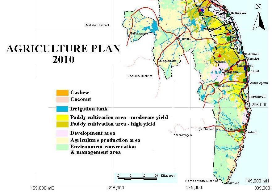
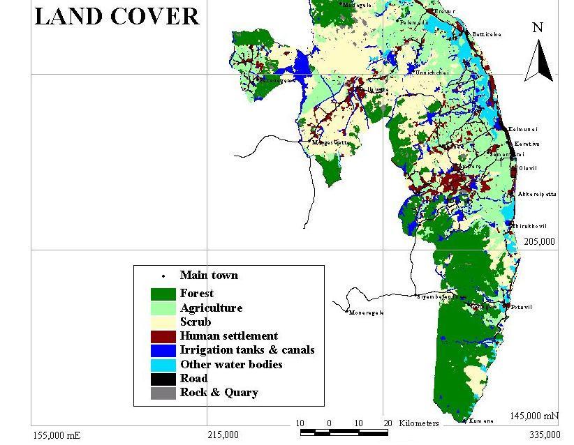
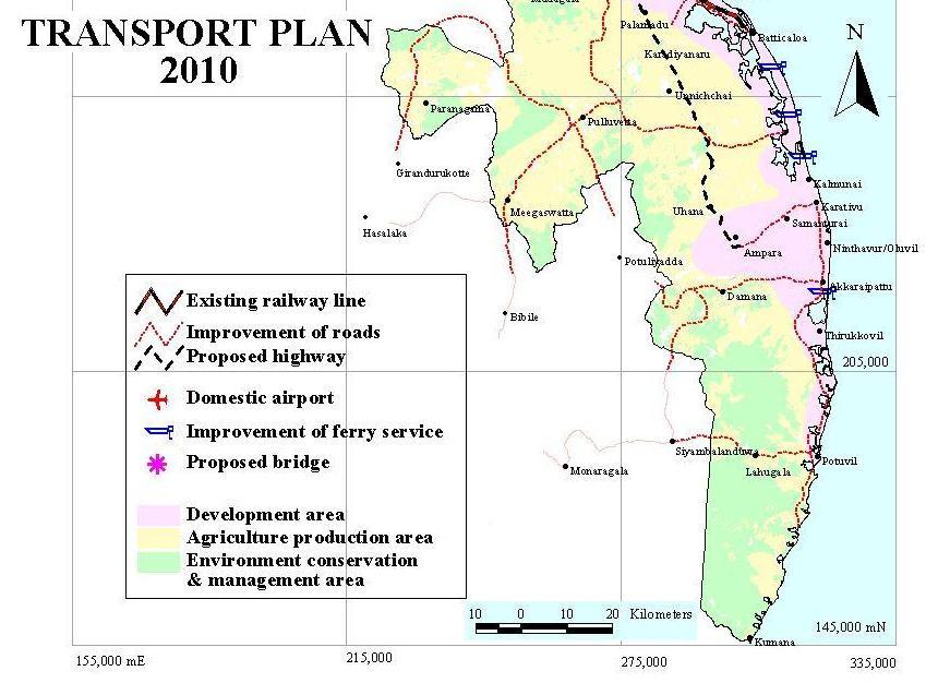
4 Government Organization, were used for mapping the study area. Secondary data were also collected from various institutions to furnish the methodology. The final integrated disaster management plans were evaluated using ground truth verification (error of omission and error of commission) and statistical analysis. 3. Results and discussions Traditional research agenda subjected to a numerous constraints which leads to erroneous conclusions; use of unreliable data in disaster management, absence of continuous monitoring, difficulties of getting real time data, variables are point measurements or observations are not possible to be interpolated to a wider geographical context, input data are not representative of the temporal dynamics of the earth processes, indiscriminate extrapolation of the localized data into a wider spatial domain can also lead to erroneous conclusions and large volumes of data from different sources and at different spatial scales are difficult to process within the modeling environment. Figure 3: Flow chart representing the process of research Geo-informatics Technology facilitates rapid data tool; remote sensing provides the synoptic observations by meteorological satellites of regional cloud patterns, precipitation distribution and other climatological and atmospheric parameters, as well as soil moisture-vegetation indices, in near real time from geosynchronous and polar orbiting satellites, have become important elements in disaster warning, damage assessment and mitigation. Geographic Information System has given an excellent environment to incorporate or superimpose the data from a variety of sources in various scales. Global Positioning System provides the location detail and mobile mapping facilities to prepare maps and locate the sites specific data. Agriculture plan for 2010, land cover map, route map 2010, transport plan 2010, environmental sensitive areas and solid waste management plans for the study area have been prepared for future development using geo-information technology. A Project Kalmunai Township Redevelopment (KTR) was designed with the use of Quick Bird Image of 6 meter resolution. The KTR project consists of three pilot projects namely coconut belt development, development of tsunami memorial park and community livelihood initiatives. 252
5 253


6 Figure 4: Images showing the proposed work plan in the study area 254
, lack of GIS experts in the region, lack of coordination between stakeholders, policy changes within")
, Information and Technology Including GIS, Routledge, London. 3. Ian Master and Michael Black More (eds.")
7 4. Limitations Figure 5: Map showing the redevelopment plan Though the research provides the expected objectives the following limitations must be eliminated in order to maximize the efficiency of the future research; high cost of finer resolution satellite images, cloud cover (Tropical Region), lack of GIS experts in the region, lack of coordination between stakeholders, policy changes within project cycle and lack of adoptability by the people.. 5. References 1. Asian Disaster Preparedness Centre, Total Disaster Risk Management, Manual, (2005), Thailand. 2. Bracken, I. Webster, C. (1990), Information and Technology Including GIS, Routledge, London. 3. Ian Master and Michael Black More (eds.), (1994), Handling Geographical Information, Methodology and Applications, Longmans Scientific and Technical, John Wily, New York. 4. Keith,Smith, (1992), Environmental hazards: assessing risk and reducing disaster. London, Routledge. 5. Sri Lanka Disaster Management Act, No.13 of (2005), Gazette of the Democratic Republic of Sri Lanka, Department of Government Printing, World Bank report on disaster response on tsunami
DISASTER INFORMATION MANAGEMENT SYSTEM Sri Lanka
 DISASTER INFORMATION MANAGEMENT SYSTEM Sri Lanka 15 March 2016 - Partnership Meeting Global Centre for Disaster Statistics SRIMAL SAMANSIRI ASSISTANT DIRECTOR R&D DISASTER MANAGEMENT CENTRE Overview Country
ColomboArts. Volume II Issue I Dynamic Trends of Intensity of Rainfall Extremes in Sri Lanka
 ColomboArts Volume II Issue I 2017 Dynamic Trends of Intensity of Rainfall Extremes in Sri Lanka R.M.S.S.Sanjeewani, 1 Lasantha Manawadu 2 1 Department of Transport and Logistics Management, University
Use of Geospatial data for disaster managements
 Use of Geospatial data for disaster managements Source: http://alertsystemsgroup.com Instructor : Professor Dr. Yuji Murayama Teaching Assistant : Manjula Ranagalage What is GIS? A powerful set of tools
Geography General Course Year 12. Selected Unit 3 syllabus content for the. Externally set task 2019
 Geography General Course Year 12 Selected Unit 3 syllabus content for the Externally set task 2019 This document is an extract from the Geography General Course Year 12 syllabus, featuring all of the content
Temperature ( C) Map 1. Annual Average Temperatures Are Projected to Increase Dramatically by 2050
 Map 1. Annual Average Temperatures Are Projected to Increase Dramatically by 2050") CO UNT RY S NA P SHO T Sri Lanka s Hotspots The Impact of Temperature and Precipitation Changes on Living Standards Climate change is already a pressing issue for Sri Lanka. Temperatures have risen considerably
CO UNT RY S NA P SHO T Sri Lanka s Hotspots The Impact of Temperature and Precipitation Changes on Living Standards Climate change is already a pressing issue for Sri Lanka. Temperatures have risen considerably
VALIDATION OF SPATIAL INTERPOLATION TECHNIQUES IN GIS
 VALIDATION OF SPATIAL INTERPOLATION TECHNIQUES IN GIS V.P.I.S. Wijeratne and L.Manawadu University of Colombo (UOC), Kumarathunga Munidasa Mawatha, Colombo 03, wijeratnesandamali@yahoo.com and lasan@geo.cmb.ac.lk
Disaster Management and Spatial Data An Experience of Sri Lanka for Joint project team meeting 2012
 Disaster Management and Spatial Data An Experience of Sri Lanka for Joint project team meeting 2012 1 by Padma Kumara Withana Provincial Surveyor General Uva Province 2 Out line ü Introduction ü Natural
Space Applications for Disaster Risk Reduction and Sustainable Development
 Space Applications for Disaster Risk Reduction and Sustainable Development Space Applications Section (SAS) ICT and Disaster Risk Reduction Division (IDD) UNESCAP Contents I. RESAP Activities 2016-2017
National Disaster Management Centre (NDMC) Republic of Maldives. Location
 Republic of Maldives. Location") National Disaster Management Centre (NDMC) Republic of Maldives Location Country Profile 1,190 islands. 198 Inhabited Islands. Total land area 300 sq km Islands range b/w 0.2 5 sq km Population approx.
National Disaster Management Centre (NDMC) Republic of Maldives Location Country Profile 1,190 islands. 198 Inhabited Islands. Total land area 300 sq km Islands range b/w 0.2 5 sq km Population approx.
Capacity Building in Applications of Remote Sensing and GIS for Disaster Management
 Capacity Building in Applications of Remote Sensing and GIS for Disaster Management M.K. Hazarika, L. Samarakoon, N. Senevirathne, J.S.M. Fowze and R. de Silva Project Researcher GeoInformatics Center
Application of remote sensing for agricultural disasters
 Application of remote sensing for agricultural disasters Bingfang Wu, Sheng Chang Institute of Remote Sensing and Digital Earth (RADI) Chinese Academy of Sciences (CAS) wubf@radi.ac.cn, changsheng@radi.ac.cn
National Platform for Disaster Risk Reduction in Sri Lanka
 National Platform for Disaster Risk Reduction in Sri Lanka Eng.(Dr) Asiri Karaunwardena Director General / National Building Research Organization Ministry of Disaster Management Sri Lanka National Platform
Natural Disasters in Member Countries (2002 Summary)
") 4.2 Member Countries and their Disaster Characteristics: Table 5: Natural Disasters in Member Countries (2002 Summary) (Country/Disaster Type/Disaster Characteristics) Data Country DisType Count of TotAff
4.2 Member Countries and their Disaster Characteristics: Table 5: Natural Disasters in Member Countries (2002 Summary) (Country/Disaster Type/Disaster Characteristics) Data Country DisType Count of TotAff
Geo-Information Technology in Disaster Management: A Case Study in Akkaraipattu Municipal Council Area
 Geo-Information Technology in Disaster Management: A Case Study in Akkaraipattu Municipal Council Area M. H. Mohamed Rinos 1 & H.M. Ranjith Premasiri 2 1 Department of Geography, South Eastern University
Mainstream Space Technology in Implementing SFDRR - GPSTAR. Srimal Samansiri Disaster Management Centre Government of Sri Lanka
 Mainstream Space Technology in Implementing SFDRR - GPSTAR Srimal Samansiri Disaster Management Centre Government of Sri Lanka SFDRR Priority Actions Effective use of Space technology in SFDRR Priority
Impacts of Disasters in Sri Lanka
 Impacts of Disasters in Sri Lanka 2016 i This publication is copyright, but may be reproduced without fee for teaching and reference purposes but not for sale. Formal permission is required from publisher
Quick Response Report #126 Hurricane Floyd Flood Mapping Integrating Landsat 7 TM Satellite Imagery and DEM Data
 Quick Response Report #126 Hurricane Floyd Flood Mapping Integrating Landsat 7 TM Satellite Imagery and DEM Data Jeffrey D. Colby Yong Wang Karen Mulcahy Department of Geography East Carolina University
Ayubowan. Management (CBDRM) Community Based Disaster Risk. Towards Disaster Resilient Community Developed by Disaster Management Centre,
 Community Based Disaster Risk. Towards Disaster Resilient Community Developed by Disaster Management Centre,") Ayubowan Community Based Disaster Risk Management (CBDRM) Towards Disaster Resilient Community 5-20 Purpose of this activity To know the risks in community to prepare for future disasters To exchange knowledge
Ayubowan Community Based Disaster Risk Management (CBDRM) Towards Disaster Resilient Community 5-20 Purpose of this activity To know the risks in community to prepare for future disasters To exchange knowledge
DIPLOMA IN DISASTER MANAGEMENT. (Non-Semester) (With effect from the academic year )
 (With effect from the academic year )") DIPLOMA IN DISASTER MANAGEMENT (Non-Semester) (With effect from the academic year 2013-14) Eligibility for the Course Candidate should have passed the Higher Secondary Examination conducted by the Board
DIPLOMA IN DISASTER MANAGEMENT (Non-Semester) (With effect from the academic year 2013-14) Eligibility for the Course Candidate should have passed the Higher Secondary Examination conducted by the Board
Capacity Building Programme
 Capacity Building Programme 14-17 August 2012 Space Technology for improving Hazard Mapping in Sri Lanka An event organised as a follow up of the UN-SPIDER Technical Advisory Mission to Sri Lanka - 17-21
Word Cards. 2 map. 1 geographic representation. a description or portrayal of the Earth or parts of the Earth. a visual representation of an area
 Name: Date: Hour: Word Cards 1 geographic representation a description or portrayal of the Earth or parts of the Earth Example: A map is a representation of an actual location or place. 2 map a visual
Building Institutional Capacity for Multi-Hazard Early Warning in Asia and the Pacific Subtitle
 Building Institutional Capacity for Multi-Hazard Early Warning in Asia and the Pacific Subtitle Title Keran Wang Chief, Space Applications Section ICT and Disaster Risk Reduction Division 22 May 2018 Pillar
Bhutan Country Report for JPTM 2010 (July, 2010) Department of Disaster Management Ministry of Home & Cultural Affairs Royal Government of Bhutan
 Department of Disaster Management Ministry of Home & Cultural Affairs Royal Government of Bhutan") Bhutan Country Report for JPTM 2010 (July, 2010) Department of Disaster Management Ministry of Home & Cultural Affairs Royal Government of Bhutan 1 Contents of Presentation 1. Disaster Hazards and Underlying
Bhutan Country Report for JPTM 2010 (July, 2010) Department of Disaster Management Ministry of Home & Cultural Affairs Royal Government of Bhutan 1 Contents of Presentation 1. Disaster Hazards and Underlying
FLOODS IN SOUTHWESTERN SRI LANKA IN MAY 2017
 FLOODS IN SOUTHWESTERN SRI LANKA IN MAY 2017 Foundation for Environment, Climate and Technology C/o Mahaweli Authority of Sri Lanka, Digana Village, Rajawella, Kandy, KY 20180, Sri Lanka Citation Lokuhetti,
Impact of Cyclone Nargis
 Lessons Learnt from Nargis Recovery for the Next Disaster International Recovery Forum (2011) 12, JAN 2011, Kobe, Japan Home for over 100 national races. Profile of Myanmar The 2 nd largest country in
The Cultural Geographer's Interest in Regions
 University of Nebraska - Lincoln DigitalCommons@University of Nebraska - Lincoln Geography Faculty Publications Geography Program (SNR) 2004 The Cultural Geographer's Interest in Regions Robert Stoddard
Climate Change in Sri Lanka: Threat, Vulnerability & Sectoral Opportunities
 Climate Change in Sri Lanka: Threat, Vulnerability & Sectoral Opportunities Ranjith Punyawardena, PhD Principal Agro-climatologist Department of Agriculture Peradeniya Greenhouse Effect Enhanced Source:
Bistandsprosjekter i Sørøst-Asia
 Bistandsprosjekter i Sørøst-Asia -Sikre liv og verdier Lars R. Hole, Hanneke Luijting, Tor Ivar Mathisen og Kristine Gjesdal September 2017 Norwegian Meteorological Institute Background Ministry of Foreign
DROUGHT ASSESSMENT USING SATELLITE DERIVED METEOROLOGICAL PARAMETERS AND NDVI IN POTOHAR REGION
 DROUGHT ASSESSMENT USING SATELLITE DERIVED METEOROLOGICAL PARAMETERS AND NDVI IN POTOHAR REGION Researcher: Saad-ul-Haque Supervisor: Dr. Badar Ghauri Department of RS & GISc Institute of Space Technology
Coastal Inundation Forecasting Demonstration Project CIFDP. Flood Forecasting Initiative-Advisory Group (FFI-AG 3), Geneva, 5-7 Dec, 2017
, Geneva, 5-7 Dec, 2017") Coastal Inundation Forecasting Demonstration Project CIFDP Flood Forecasting Initiative-Advisory Group (FFI-AG 3), Geneva, 5-7 Dec, 2017 Coastal Flooding & Vulnerable Populations Coastal populations are
Coastal Inundation Forecasting Demonstration Project CIFDP Flood Forecasting Initiative-Advisory Group (FFI-AG 3), Geneva, 5-7 Dec, 2017 Coastal Flooding & Vulnerable Populations Coastal populations are
WHO Conference on Health Aspects of Tsunami Disaster in Asia. Phuket,, Thailand 4 66 May 2005
 WHO Conference on Health Aspects of Tsunami Disaster in Asia Phuket,, Thailand 4 66 May 2005 Who Was Affected? The Demography of Tsunami-Affected Population Deborah Balk and Yuri Gorokhovich Center for
GIS BASED ANALYSIS ON ENVIRONMENTAL SENSITIVE AREAS AND IDENTIFICATION OF THE POTENTIAL DISASTER HAZARDOUS LOCATIONS IN SOUTHERN SRI LANKA
 International Journal of Civil & Environmental Engineering IJCEE Vol: 9 No: 9-311 - GIS BASED ANALYSIS ON ENVIRONMENTAL SENSITIVE AREAS AND IDENTIFICATION OF THE POTENTIAL DISASTER HAZARDOUS LOCATIONS
Sri Lanka Enhancing the Role of ICTs for Disaster Risk Management
 Workshop on ICT for Promoting Inclusive and Disaster Resilient Development Ulaanbaatar, Mongolia Sri Lanka Enhancing the Role of ICTs for Disaster Risk Management Kanchana Thudugala Programme Head, eservices
Report of the Working Group 2 Data Sharing and Integration for Disaster Management *
 UNITED NATIONS E/CONF.104/6 ECONOMIC AND SOCIAL COUNCIL Twentieth United Nations Regional Cartographic Conference for Asia and the Pacific Jeju, 6-9 October 2015 Item 5 of the provisional agenda Report
- facilitate the preparation of landslide inventory and landslide hazard zonation maps for the city, - development of precipitation thresholds,
 Date of Submission 29.03.2012 IPL Project Proposal Form 2012 (MAXIMUM: 3 PAGES IN LENGTH) 1. Project Title: (2 lines maximum)-introducing Community-based Early Warning System for Landslide Hazard Management
VULNERABILITY FUNCTIONS FOR BUILDINGS BASED ON DAMAGE SURVEY DATA IN SRI LANKA AFTER THE 2004 INDIAN OCEAN TSUNAMI. Murao, O. 1, Nakazato, H.
 371 VULNERABILITY FUNCTIONS FOR BUILDINGS BASED ON DAMAGE SURVEY DATA IN SRI LANKA AFTER THE 2004 INDIAN OCEAN TSUNAMI Murao, O. 1, Nakazato, H. 2 1 Graduate School of Systems and Information Engineering,
Disaster RISK Management : Bhutanese Scenario
 Disaster RISK Management : Bhutanese Scenario Expert Group Meeting (EGM) on Geo-referenced Information Systems for Disaster Risk Management (Geo-DRM) and sustaining the Community of Practice (COP), Bangkok,
STATUS OF HAZARD MAPS VULNERABILITY ASSESSMENTS AND DIGITAL MAPS
 JapanInternational Cooperation Agency STATUS OF HAZARD MAPS VULNERABILITY ASSESSMENTS AND DIGITAL MAPS ANGUILLA REPORT THE CARIBBEAN DISASTER EMERGENCY RESPONSE AGENCY () Table of Contents Page Preface
Disaster Risk Assessment: Opportunities for GIS and data management with Open DRI
 Disaster Risk Assessment: Opportunities for GIS and data management with Open DRI Jacob Opadeyi Department of Geomatics Engineering and Land Management, The University of the West Indies, St. Augustine,
Improving global coastal inundation forecasting WMO Panel, UR2014, London, 2 July 2014
 Improving global coastal inundation forecasting WMO Panel, UR2014, London, 2 July 2014 Cyclone Sidr, November 2007 Hurricane Katrina, 2005 Prof. Kevin Horsburgh Head of marine physics, UK National Oceanography
Tectonic Processes and Hazards Enquiry Question 1: Why are some locations more at risk from tectonic hazards?
 Tectonic Processes and Hazards Enquiry Question 1: Why are some locations more at risk from tectonic hazards? Key words Basalt Andesite Rhyolite Benioff Zone Subduction zone Crustal fracturing Definition
Roles of NGII in successful disaster management
 The Second UN-GGIM-AP Plenary Meeting Roles of NGII in successful disaster management Republic of Korea Teheran Iran 28 October 2013 Sanghoon Lee, Ph.D. NGII Outline Type of Disasters Occur in Korea Practical
Theme 4. Disaster Mitigation and Risk Management
 Theme 4 Disaster Mitigation and Risk Management World Flood Map in 2002 Released by WMO as of August 29 Over 17 million were affected (in more than 80 countries) 3,000 were killed Total damage of over
Country Report Nepal Geospatial Data Sharing Initiatives of Survey Department Supporting Disaster Management
 Third JPTM Step 2 for Sentinel Asia 6-8 July, 2010 Manila, The Philippines Country Report Nepal Geospatial Data Sharing Initiatives of Survey Department Supporting Disaster Management Durgendra M Kayastha
Indian Ocean Tsunami Warning System: Example from the 12 th September 2007 Tsunami
 Indian Ocean Tsunami Warning System: Example from the 12 th September 2007 Tsunami Charitha Pattiaratchi 1 Professor of Coastal Oceanography, The University of Western Australia Email: chari.pattiaratchi@uwa.edu.au
RESAP Progress Report
 RESAP Progress Report December 2016 to October 2017 Presentation to the Twenty-first session of the Intergovernmental Consultative Committee on the Regional Space Applications Programme for Sustainable
COUNTRY PRESENTATION ON MR JAYNAL ABEDIN JOINT SECRETARY ( WORKS & DEVELOPMENT ) MINISTRY OF DEFENCE
 MINISTRY OF DEFENCE") COUNTRY PRESENTATION ON By MR JAYNAL ABEDIN JOINT SECRETARY ( WORKS & DEVELOPMENT ) MINISTRY OF DEFENCE Bangladesh Geographical Location of Bangladesh Bangladesh Country at a Glance Physical Features 1,230
COUNTRY PRESENTATION ON By MR JAYNAL ABEDIN JOINT SECRETARY ( WORKS & DEVELOPMENT ) MINISTRY OF DEFENCE Bangladesh Geographical Location of Bangladesh Bangladesh Country at a Glance Physical Features 1,230
Geomatics: Geotechnologies in Action, Grade 12, University/College Expectations
 Geographic Foundations: Space and Systems SSV.01 explain how the earth is modelled for scientific and mapping purposes; SSV.02 demonstrate an understanding of basic spatial concepts; Page 1 SSV.03 explain
UNITED NATIONS E/CONF.96/CRP. 5
 UNITED NATIONS E/CONF.96/CRP. 5 ECONOMIC AND SOCIAL COUNCIL Eighth United Nations Regional Cartographic Conference for the Americas New York, 27 June -1 July 2005 Item 5 of the provisional agenda* COUNTRY
Disaster Prevention and Management in Asia: The Context of Human Security and Its Relevance to Infrastructure Planning and Management
 Disaster Prevention and Management in Asia: The Context of Human Security and Its Relevance to Infrastructure Planning and Management Rajib Shaw http://www.iedm.ges.kyoto-u.ac.jp/ Contents Background and
Site Suitability Analysis for Local Airport Using Geographic Information System
 Cloud Publications International Journal of Advanced Remote Sensing and GIS 2018, Volume 7, Issue 1, pp. 2719-2727 ISSN 2320 0243, Crossref: 10.23953/cloud.ijarsg.368 Research Article Site Suitability
West Carroll Parish Hazard Mitigation Plan Update Public Meeting. August 25, 2015 Oak Grove, LA
 West Carroll Parish Hazard Mitigation Plan Update Public Meeting August 25, 2015 Oak Grove, LA Agenda Hazard Mitigation Planning Process SDMI Staff Risk Assessment SDMI Staff Update on Previous/Current
Georeferencing and Satellite Image Support: Lessons learned, Challenges and Opportunities
 Georeferencing and Satellite Image Support: Lessons learned, Challenges and Opportunities Shirish Ravan shirish.ravan@unoosa.org UN-SPIDER United Nations Office for Outer Space Affairs (UNOOSA) UN-SPIDER
WEATHER AND CLIMATE EXTREMES MONITORING BASED ON SATELLITE OBSERVATION : INDONESIA PERSPECTIVE RIRIS ADRIYANTO
 WEATHER AND CLIMATE EXTREMES MONITORING BASED ON SATELLITE OBSERVATION : INDONESIA PERSPECTIVE RIRIS ADRIYANTO INDONESIA AGENCY FOR METEOROLOGY, CLIMATOLOGY AND GEOPHYSICS (BM KG) 1. INTRODUCTION - BMKG
Smart use of Geographic Information System (GIS) platform for delivering weather information and nowcasting services
 platform for delivering weather information and nowcasting services") Smart use of Geographic Information System (GIS) platform for delivering weather information and nowcasting services C. K. Pan Hong Kong Observatory Hong Kong, China It is a world of beauty Source: Image
Smart use of Geographic Information System (GIS) platform for delivering weather information and nowcasting services C. K. Pan Hong Kong Observatory Hong Kong, China It is a world of beauty Source: Image
Country Report Vanuatu
 Country Report Vanuatu Ministry Infrastructure and Public Utilities. Application of Space Technology and the Geographic information system for DRR and Sustainable Development 18 th 22 nd December 2012
Global Map: A Tool for Disaster Mitigation for the Asia and Pacific Region
 Global Map: A Tool for Disaster Mitigation for the Asia and Pacific Region D. R. Fraser Taylor Chair, International Steering Committee for Global Mapping (ISCGM) fraser_taylor@carleton.ca www. 18 th United
Building Disaster Resilience Community in Asia: Indonesian perspective
 Workshop C of the 7th Science Council of Asia (SCA) Conference Construction of Secure and Safe Society against Global Changes of Natural Disasters Okinawa, June 14 th, 2007 Building Disaster Resilience
Identifying Audit, Evidence Methodology and Audit Design Matrix (ADM)
") 11 Identifying Audit, Evidence Methodology and Audit Design Matrix (ADM) 27/10/2012 Exercise XXX 2 LEARNING OBJECTIVES At the end of this session participants will be able to: 1. Identify types and sources
11 Identifying Audit, Evidence Methodology and Audit Design Matrix (ADM) 27/10/2012 Exercise XXX 2 LEARNING OBJECTIVES At the end of this session participants will be able to: 1. Identify types and sources
World Meteorological Organization
 World Meteorological Organization Opportunities and Challenges for Development of Weather-based Insurance and Derivatives Markets in Developing Countries By Maryam Golnaraghi, Ph.D. Head of WMO Disaster
WMO Statement on the State of the Global Climate Preliminary conclusions for 2018 and WMO Greenhouse Bulletin
 WMO Statement on the State of the Global Climate Preliminary conclusions for 2018 and WMO Greenhouse Bulletin Dr Elena Manaenkova Deputy Secretary General World Meteorological Organisation Statement on
Republic of Mozambique
 Republic of Mozambique Second Expert's Symposium on Multi-Hazard Early Warning Systems with focus on the Role of National Meteorological and Hydrological Services 5-7 May 2009, Toulouse France 1. Background
Abdolreza Ansari Amoli. Remote Sensing Department Iranian Space Agency
 Risk Assessment and Mapping Using Earth Observation Data In Iran Abdolreza Ansari Amoli Remote Sensing & GIS Expert Remote Sensing Department Iranian Space Agency Different Types of Disasters in Iran Epidemic
Semester: Two. Study Hours: 28 contact/80 independent BSU Credits: 10 ECTS: 5
 BATH SPA UNIVERSITY Erasmus, exchange & study abroad module catalogue Geography: semester 2 Modules at Bath Spa University are usually worth either 10, 20 or 40 credits. If you are using the European Credit
M14/3/GEOGR/SP2/ENG/TZ0/XX/Q GEOGRAPHY STANDARD LEVEL PAPER 2. Monday 19 May 2014 (morning) 1 hour 20 minutes INSTRUCTIONS TO CANDIDATES
 1 hour 20 minutes INSTRUCTIONS TO CANDIDATES") M14/3/GEOGR/SP2/ENG/TZ0/XX/Q 22145203 GEOGRAPHY STANDARD LEVEL PAPER 2 Monday 19 May 2014 (morning) 1 hour 20 minutes INSTRUCTIONS TO CANDIDATES Do not open this examination paper until instructed to do
M14/3/GEOGR/SP2/ENG/TZ0/XX/Q 22145203 GEOGRAPHY STANDARD LEVEL PAPER 2 Monday 19 May 2014 (morning) 1 hour 20 minutes INSTRUCTIONS TO CANDIDATES Do not open this examination paper until instructed to do
Report. Developing a course component on disaster management
 Report Developing a course component on disaster management By Chira Prangkio Tawee Chaipimonplin Department of Geography, Faculty of Social Sciences, Chiang Mai University Thailand Presented at Indian
DROUGHT RISK EVALUATION USING REMOTE SENSING AND GIS : A CASE STUDY IN LOP BURI PROVINCE
 DROUGHT RISK EVALUATION USING REMOTE SENSING AND GIS : A CASE STUDY IN LOP BURI PROVINCE K. Prathumchai, Kiyoshi Honda, Kaew Nualchawee Asian Centre for Research on Remote Sensing STAR Program, Asian Institute
Historical background
 Space Technology for Disaster Management in Sri Lanka: Country profile, national perspectives & vision. Professor Ranjith Premalal De Silva Vice Chancellor Uva Wellassa University of Sri Lanka October
March 2007 The Survey Department of Sri Lanka
 Contribution of Survey Department of Sri Lanka for Mitigation of Disasters in Sri Lanka K.A.U.N.Kasthuri Deputy Surveyor General (Information Technology) March 2007 The Survey Department of Sri Lanka 1
Chapter 2- Background of Urbanization and Remote Sensing of Urban Environment
 ... Chapter 2- Background of Urbanization and Remote Sensing of Urban Environment 2.0 Introduction This chapter discusses two conceptual bases relevant to this research. Urbanization pattern, distribution
USE OF GEOREFERENCE INFORMATION FOR DRM Arnob Bormdoi Research Associate, GIC
 USE OF GEOREFERENCE INFORMATION FOR DRM Arnob Bormdoi Research Associate, GIC CONTENTS INTRODUCTION THE IMPORTANCE OF SPATIAL INFORMATION CASE STUDIES SUMMARY INTRODUCTION The process of defining how raster
3 rd Ministerial Conference and 9th Council meeting of the Regional Integrated Multi Hazard Early Warning Systems (RIMES)
") 3 rd Ministerial Conference and 9th Council meeting of the Regional Integrated Multi Hazard Early Warning Systems (RIMES) RIMES Capacity Building For Sri Lanka Department of Meteorology Sri Lanka Out Line
3 rd Ministerial Conference and 9th Council meeting of the Regional Integrated Multi Hazard Early Warning Systems (RIMES) RIMES Capacity Building For Sri Lanka Department of Meteorology Sri Lanka Out Line
JCOMM-CHy Coastal Inundation Forecasting Demonstration Project (CIFDP)
") WMO World Meteorological Organization Working together in weather, climate and water JCOMM-CHy Coastal Inundation Forecasting Demonstration Project (CIFDP) Coastal Flooding & Vulnerable Populations Coastal
WMO World Meteorological Organization Working together in weather, climate and water JCOMM-CHy Coastal Inundation Forecasting Demonstration Project (CIFDP) Coastal Flooding & Vulnerable Populations Coastal
GEOMATICS. Shaping our world. A company of
 GEOMATICS Shaping our world A company of OUR EXPERTISE Geomatics Geomatics plays a mayor role in hydropower, land and water resources, urban development, transport & mobility, renewable energy, and infrastructure
Barnabas Chipindu, Department of Physics, University of Zimbabwe
 DEFICIENCIES IN THE OPERATIONAL APPLICATIONS OF LONG - RANGE WEATHER PREDICTIONS FOR AGRICULTURE - RECOMMENDATIONS FOR IMPROVING THE TECHNOLOGY FOR THE BENEFIT OF AGRICULTURE AT THE NATIONAL AND REGIONAL
Hurricanes. Cause: a low pressure storm system over warm ocean water. Effect: potential massive widespread destruction and flooding.
 Hurricanes Hurricanes Cause: a low pressure storm system over warm ocean water. Effect: potential massive widespread destruction and flooding. Hurricanes also known as: cyclone (Indian Ocean) or typhoon
Disaster Risk Management in India. Kamal Kishore New Delhi, 27 October 2016
 Disaster Risk Management in India Kamal Kishore New Delhi, 27 October 2016 Hazard, Exposure and Vulnerability Disaster Prevention Mitigation Hurricane Matthew: Cuba & Haiti Emergency Response Coordination
Paper Two - Optional Themes for Standard and Higher Level
 Paper Two - Optional Themes for Standard and Higher Level Timing: Approximately 40 minutes for each question (each is worth 20 marks). Choice: Higher Level candidates must answer three questions and Standard
Recent development of the National Hydro-Meteorological Service (NHMS) of Viet Nam for disaster risk reduction
 of Viet Nam for disaster risk reduction") Ministry of Natural Resources and Environment National Hydro-Meteorological Service Recent development of the National Hydro-Meteorological Service (NHMS) of Viet Nam for disaster risk reduction Tran Van
Ministry of Natural Resources and Environment National Hydro-Meteorological Service Recent development of the National Hydro-Meteorological Service (NHMS) of Viet Nam for disaster risk reduction Tran Van
TOOLS AND DATA NEEDS FOR FORECASTING AND EARLY WARNING
 TOOLS AND DATA NEEDS FOR FORECASTING AND EARLY WARNING Professor Richard Samson Odingo Department of Geography and Environmental Studies University of Nairobi, Kenya THE NEED FOR ADEQUATE DATA AND APPROPRIATE
GEOGRAPHY YEAR 11 ATAR 2019 COURSE OUTLINE
 GEOGRAPHY YEAR 11 ATAR 2019 COURSE OUTLINE Geography ATAR Year 11 Semester 1 Unit 1 Natural and ecological hazards 1 3 Geographical skills Mapping skills identify and interpret a variety of topographic
GIS in Weather and Society
 GIS in Weather and Society Olga Wilhelmi Institute for the Study of Society and Environment National Center for Atmospheric Research WAS*IS November 8, 2005 Boulder, Colorado Presentation Outline GIS basic
Role of GIS and Remote Sensing to Environment Statistics
 United Nations Economic Commission for Africa Role of GIS and Remote Sensing to Environment Dozie Ezigbalike Data Management Coordinator A Definition Environment statistics are statistics that describe
Syllabus Post Graduate Diploma in Disaster Management (PGDDM)
") Syllabus Post Graduate Diploma in Disaster Management (PGDDM) Programme Objective: The Programme has been framed with an intention to provide a general concept in the dimensions of disasters caused by
Syllabus Post Graduate Diploma in Disaster Management (PGDDM) Programme Objective: The Programme has been framed with an intention to provide a general concept in the dimensions of disasters caused by
FLOOD DAMAGE ASSESSMENT INTEGRATING GEOSPATIAL TECHNOLOGIES. A CASE STUDY IN HUE, VIET NAM
 Paper 5-4-2 FLOOD DAMAGE ASSESSMENT INTEGRATING GEOSPATIAL TECHNOLOGIES. A CASE STUDY IN HUE, VIET NAM DINH NGOC DAT, J. S. M. FOWZE, NGUYEN DUONG ANH, MANZUL K. HAZARIKA AND LAL SAMARAKOON GeoInformatics
4 th Joint Project Team Meeting for Sentinel Asia 2011
 A Revisit on the Structural Flood Mitigation Measure with the Application of Remote Sensing and GIS in Gin River Basin, Sri Lanka 4 th Joint Project Team Meeting for Sentinel Asia 2011 Geoinformatics Center
RISK OF PRINCIPAL DISASTERS IN INDIA AND IMPACTS OF DISASTERS ON ECONOMIC DEVELOPMENT
 RISK OF PRINCIPAL DISASTERS IN INDIA AND IMPACTS OF DISASTERS ON ECONOMIC DEVELOPMENT At the Himachal Pradesh Institute of Public Administration Shimla 05. 05.2012 Improve Disaster Management with the
Advanced Image Analysis in Disaster Response
 Advanced Image Analysis in Disaster Response Creating Geographic Knowledge Thomas Harris ITT The information contained in this document pertains to software products and services that are subject to the
Effects of climate change on landslide frequencies in landslide prone districts in Sri Lanka; Overview
 Effects of climate change on landslide frequencies in landslide prone districts in Sri Lanka; Overview T. D. Rathnaweera 1)., M. P. Palihawadana 2)., H. L. L. Rangana 3). and Dr. U. P. Nawagamuwa 4). Abstract
Land Administration and Cadastre
 Geomatics play a major role in hydropower, land and water resources and other infrastructure projects. Lahmeyer International s (LI) worldwide projects require a wide range of approaches to the integration
Overview of Philippine Geohazards Programs
 Overview of Philippine Geohazards Programs 53 rd CCOP Annual Session CCOP-IUGS Task Group on Geohazards Joint Seminar Cebu City, PHILIPPINES October 18, 2017 Renato U. Solidum, Jr. Department of Science
INSPIRE Basics. Vlado Cetl European Commission Joint Research Centre. https://ec.europa.eu/jrc/
 INSPIRE Basics Vlado Cetl European Commission Joint Research Centre https://ec.europa.eu/jrc/ Serving society Stimulating innovation Supporting legislation Outline SDI? Why European SDI? INSPIRE Policy
Brazil Paper for the. Second Preparatory Meeting of the Proposed United Nations Committee of Experts on Global Geographic Information Management
 Brazil Paper for the Second Preparatory Meeting of the Proposed United Nations Committee of Experts on Global Geographic Information Management on Data Integration Introduction The quick development of
Sub-regional Training on development of Geo-referenced Disaster Risk Management Information Systems for SAARC countries
 Sub-regional Training on development of Geo-referenced Disaster Risk Management Information Systems for SAARC countries Jointly organized by Economic and Social Commission for Asia and the Pacific and
Overview of the global FFGS
 Overview of the global FFGS 1 Definition of the Problem While there are several types of floods, flash floods are the most dangerous. Flash Flood is: a flood of short duration with a relatively high peak
Formulation of the Strategy for Disaster Risk Reduction and Emergency Preparedness and Response of the Asia-Pacific Region
 2008/SOM3/TFEP/SEM/006 Formulation of the Strategy for Disaster Risk Reduction and Emergency Preparedness and Response of the Asia-Pacific Region 2009-2015 Submitted by: Thailand Emergency Management CEOs
EARLY WARNING IN SOUTHERN AFRICA:
 EARLY WARNING IN SOUTHERN AFRICA: Enhancing the Meteorological Early Warning System Eugene Poolman South African Weather Service OUTLINE OF PRESENTATION Impact of Climate Change Meteorological Early Warning
DAGUPAN CITY EXPERIENCES, GOOD PRACTICES, CHALLENGES AND LESSONS LEARNED ON DISASTER RISK MANAGEMENT
 DAGUPAN CITY EXPERIENCES, GOOD PRACTICES, CHALLENGES AND LESSONS LEARNED ON DISASTER RISK MANAGEMENT Reducing Vulnerability to Climate Change Impacts and Related Natural Disasters in East Asia 12 and 13
Early Warning System and Role of IMD. Manmohan Singh Meteorological Centre Shimla
 Early Warning System and Role of IMD Manmohan Singh Meteorological Centre Shimla India a land with a unique climatic regime Two monsoon seasons (southwest & northeast monsoons) Two cyclone seasons (pre
2014 Summer training course for slope land disaster reduction Taipei, Taiwan, Aug
 MINISTRY OF SCIENCE AND TECHNOLOGY HYDROTECH RESEARCH INSTITUTE MINISTRY OF NATURAL RESOURCES AND ENVIRONMENT VIETNAM INSTITUTE OF GEOSCIENCES AND MINERAL RESOURCES (VIGMR) 2014 Summer training course