Urban Recovery Process in Pisco After the 2007 Peru Earthquake
|
|
|
- Patrick Stone
- 6 years ago
- Views:
Transcription
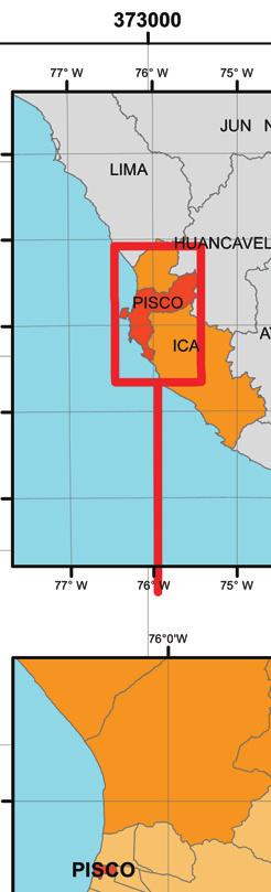
1 Paper: Urban Recovery Process in Pisco After the 2007 Peru Earthquake Osamu Murao 1, Tomoyo Hoshi 1, Miguel Estrada 2, Kazuya Sugiyasu 1, Masashi Matsuoka 3, and Fumio Yamazaki 4 1 Graduate School of Systems and Information Engineering, University of Tsukuba Tennodai, Tsukuba, Ibaraki , Japan murao@risk.tsukuba.ac.jp 2 Japan-Peru Center for Earthquake Engineering Research and Disaster Mitigation (CISMID), National University of Engineering Av. Tupac Amaru 1150, Rimac, Lima, Peru 3 Interdisciplinary Graduate School of Science and Engineering, Tokyo Institute of Technology 4259-G3-2, Nagatsuta, Midori-ku, Yokohama , Japan 4 Department of Urban Environment Systems, Chiba University 1-33 Yayoi-cho, Inage-ku, Chiba , Japan [Received November 1, 2012; accepted December 14, 2012] Post-disaster urban recovery is a significant matter in disaster management that represents government efforts after a disaster and victim satisfaction with these efforts in affected areas. Understanding the recovery process is a procedure necessary for evaluating government strategy. From this view, the authors dealt with the recovery process at Pisco, the area most devastated in the 2007 Peru Earthquake. Research was conducted through the following procedure: (1) a field survey including interviews was carried out in July 2012 to clarify post-earthquake conditions in urban Pisco, especially from the viewpoint of the physical environment, (2) recovery conditions were compared with damage conditions investigated by CIS- MID just after the event using satellite imaging and building recovery data obtained in the survey, and (3) post-earthquake recovery was quantitatively analyzed in terms of building recovery. Results indicated that 93.2% of seriously or severely damaged buildings had been reoccupied. In addition to quantitative analysis, recovery-related problems are discussed based on interviews. Results will be useful in the next stage of our research using remote sensing data for the chronological understanding of the post-earthquake urban recovery process in Pisco. Keywords: 2007 Peru Earthquake, Pisco, urban recovery process, building examination, satellite image 1. Introduction The Mw 8.0 Pisco Earthquake occurred on August 15, The epicenter was about 145 km southeast of Lima. Ica Region was the area most seriously damaged due to the earthquake, in which 134,312 houses were affected. Pisco District, our research object, is located in the middle of Pisco Province (Fig. 1). The number of affected houses in the district was 14,008, including 4,106 collapsed buildings [1]. In general, post-disaster urban recovery is a significant matter in disaster management that represents government efforts after a disaster and victim satisfaction with these efforts in affected areas. Understanding the recovery process is a procedure necessary for evaluating government strategy. From this view, the authors dealt with the recovery process in the Pisco District in order to clarify the current status of rebuilding and recovery efforts after the 2007 Pisco Earthquake. Just after the earthquake, lots of damage surveys were conducted and damage conditions were reported by institutes such as EERI [2], or JSCE and JAEE [3]. The number of research papers on the recovery process is comparatively few, however [4]. This paper mainly reports how the city has recovered in the five years since Framework of Research on Recovery Process in Pisco The procedure employed in research is detailed in the sections that follow Perspectives of Field Survey A field survey was carried out in July 2012 to clarify post-earthquake conditions in urban Pisco, especially from the viewpoint of the physical environment. The authors then conducted interviews with salesclerks in building-materials stores about temporary housing Comparison Between Damage Conditions and Current Status Using Satellite Imaging Current recovery conditions are compared with damage conditions investigated by CISMID in 2007 using satellite imaging and building recovery data obtained in the survey Analysis of Rebuilding Conditions Post-earthquake recovery was quantitatively analyzed in terms of building recovery based on the above com- 356 Journal of Disaster Research Vol.8 No.2, 2013
.")


.")
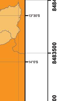
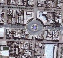
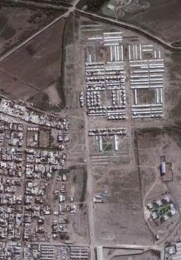
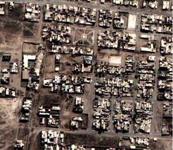
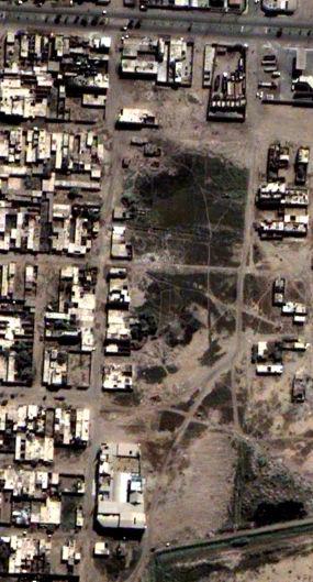
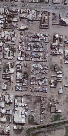
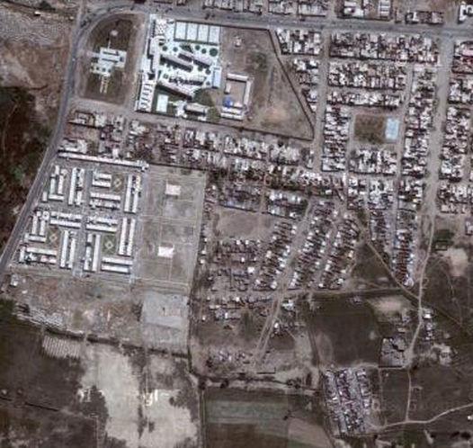
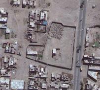
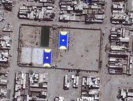
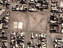
2 Urban Recovery Process in Pisco After the 2007 Peru Earthquake Pisco Fig. 2. Central San Clemente Cathedral of Pisco. Fig. 3. Recovery of public facilities. Fig. 1. Location of Pisco Province (INDECI). parative study. It refers to the building recovery ratio and newly developed areas that had changed dramatically for five years Discussion Apart from the quantitative consideration, it is important to follow the qualitative aspects such as the support system for affected residents. Recovery-related problems are discussed based on interviews. Fig. 4. Empty lots. 3. Field Survey in July Outline of the Survey The field survey in Pisco District was carried out on July 7, 8, and 9, The authors made photographic or video records of building conditions in the whole area by walking and driving about 98 km. After the survey, the authors had an opportunity to ask salesclerks at building-materials stores about the construction of temporary housing Recovery Status Observation Some important facilities are concentrated in the central area of Pisco. Most of them had been reoccupied by the time of the field survey. Fig. 2 shows the recovery status of the Central San Clemente Cathedral of Pisco, which had been seriously damaged by the earthquake. Fig. 3 shows two other public buildings, City Hall and the Police Station. Walking around in central Pisco, we found many unrebuilt lots, as shown in Fig. 4. The government provided some subsidies to affected householders who lost their houses in the earthquake. However, living in temporary housing prepared by NGOs, Fig. 5. New front gate instead of solid new house. some of those receiving subsidies used the money for installing new front gates as symbols of their houses (Fig. 5). Several new settlements developed in the outskirts of the Pisco District will be discussed in the next chapter Temporary Housing In order to coordinate reconstruction efforts, the Fund for the Reconstruction of the South (FORSUR) was established just after the earthquake. Fig. 6 illustrates the reconstruction stage indicated by FORSUR [5]. Temporary housing were supposed to be in a stage of transition according to FORSUR recovery strategy. There remained many temporary housing around the district, however, when the authors investigated. There were also blocks that were occupied by temporary housing as new settlements into which affected people moved after the event (Fig. 7). Journal of Disaster Research Vol.8 No.2,
![Fig. 6. Reconstruction stage in FORSUR strategy [5]. Fig. 7. Remaining temporary housing. Fig. 8. Temporary house construction.](/docs-images/76/73492715/images/3-0.jpg "The authors then visited a few building-materials stores to get some information on temporary housing construction (Fig. 8).")

 The total price of the material, not including handling, and time necessary for construction is [3 3m] S/.1,350 ($519), one day [3 4m] S/.1,600 ($615), two days [3 6m] S/.2,400 ($922), two days.")


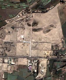
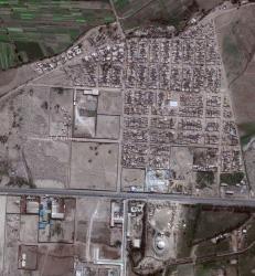
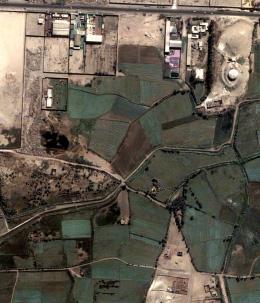
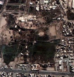
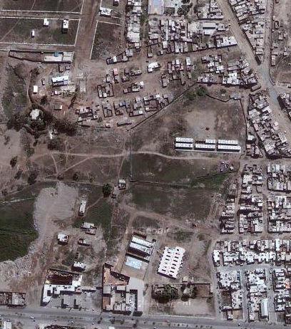
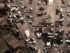
3 Fig. 6. Reconstruction stage in FORSUR strategy [5]. Fig. 7. Remaining temporary housing. Fig. 8. Temporary house construction. The authors then visited a few building-materials stores to get some information on temporary housing construction (Fig. 8). Salesclerks gave us information useful for understanding the temporary house construction situation as follows: (1) Although house units for sale are not for temporary housing but for huts, affected people often buy them themselves, and they are not provided by the government for temporary use. (2) If the user daubs house parts with waterproof paint once a year and changes the roof often, the house can be used for about ten years. It does not last long without maintenance. (3) The total price of the material, not including handling, and time necessary for construction is [3 3m] S/.1,350 ($519), one day [3 4m] S/.1,600 ($615), two days [3 6m] S/.2,400 ($922), two days. Exchange rate: as of Oct. 30, Recovery Conditions in Pisco This chapter examines recovery conditions in Pisco based on the field survey and satellite imaging Data Used In order to quantitatively compare current recovery status with the building damage situation in Pisco, GIS dataset produced by CISMID and satellite image in additiontorecordsbythesurvey. Satellite imaging from QuickBird taken on June 3, 2007, for pre-earthquake status and on August 27, 2007, for post-earthquake status were used. To better understand the current situation, imaging from GeoEye taken on July 10, 2010, was used. GIS data used for analysis was produced by CISMID just after the earthquake. CISMID conducted continuous building damage surveys, and developed the database. Polygon data for recognizing building damage conditions is distinguished by lot, and the building damage level is classified into four types: serious, severe, slight, and no damage. Imaging of building damage conditions made by CISMID is shown in Fig. 9. Although Matsuzaki et al. [6] point out some amounts of omission error in GIS data, it is valuable for grasping the damage situation Examination of Recovery Conditions While there were many reoccupied buildings in the field survey, there also remained many empty lots that seemed not to have been reoccupied after destruction. Making the assumption that the condition of empty lots represents the current recovery situation in Pisco, the authors examined recovery conditions using satellite imaging and GIS data. The area for this analysis was determined by GIS coverage. At first empty lots were macroscopically distinguished using the image map of The authors then examined the adequacy of lots chosen lots based on the damage levels in GIS investigated by CISMID. Empty lots included misjudged data, however, as pointed out by Matsuzaki [6], such as a lot that had been not occupied by any buildings since before the earthquake. The original empty lots were, therefore, eliminated from among objects for analysis. Figure 10 shows the map resulting from this process: yellow polygons means are empty lots, and transparent polygons with green lines indicate new developed areas, which will be explained in the next section. Empty lots were picked based on a comparison between 2007 and 2010 maps, as shown in Fig. 11. The number of polygons in terms of damage level with empty lots was counted as shown in Table 1. The total number of polygons is 12,079 according to CISMID 358 Journal of Disaster Research Vol.8 No.2, 2013


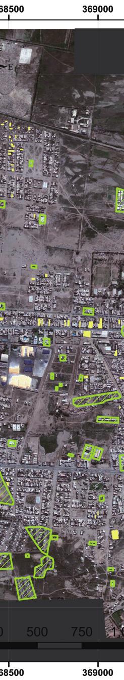
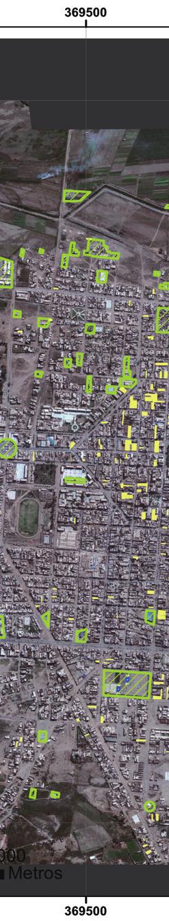
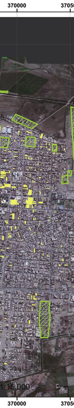
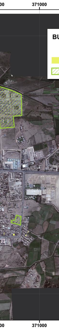
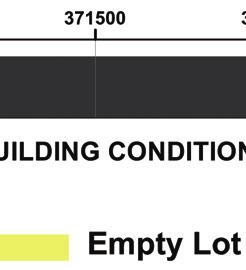
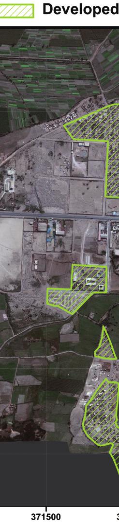
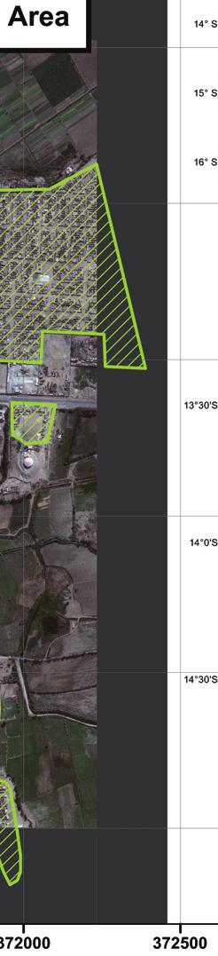
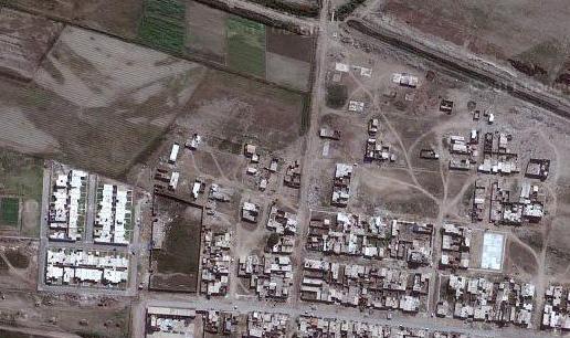
4 Urban Recovery Process in Pisco After the 2007 Peru Earthquake Fig. 9. Building damage conditions due to the 2007 Peru Earthquake (CISMID). Fig. 10. Recovery conditions based on satellite imaging as of July 2010 and the field survey in July Journal of Disaster Research Vol.8 No.2,
 (a) (b) (b/a) Serious")
 10,923 10,851 488 95.")


.")


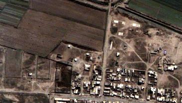
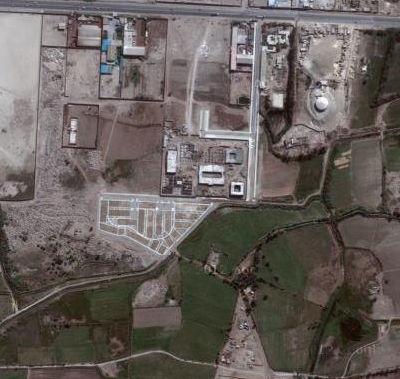
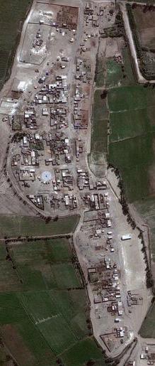
5 Table 1. Number of polygons in terms of damage level. Damage level Total by CISMID Total after the elimination Empty lot Recovery ratio (%) (a) (b) (b/a) Serious 3,181 3, Severe 3,449 3, Sub total (Damage basis) 6,630 6, Slight 2,780 2, No damage 1,513 1, Sub total (Whole basis) 10,923 10, No Data 1,149 1, Others Total 12,079 12, Fig. 11. Empty lots selection based on comparison between 2007 and 2010 imaging. Number of lots 12,000 10,000 8,000 6,000 4,000 2, before EQ Serious Severe Slight after EQ Recovery Condition Fig. 12. Damage and recovery condition. No damage data, but the figure after the elimination is used to evaluate recovery conditions here. Polygons categorized into no data and others are counted, too. Fig. 12 shows damage and recovery conditions as results of analysis. Based on analysis, 87.6% of seriously damaged buildings and 98.3% of severely damaged buildings had been reoccupied by the time of the survey. The recovery Ratio can be counted from two aspects: one is the damage basis based on seriously and severely damaged buildings, and the other is the whole basis based on all buildings in the object area. Results are 93.2% on the damage basis and 95.5% on the whole basis though evaluation did not consider types of houses, i.e., temporary or permanent. Pisco District had achieved more than Fig. 13. Housing project for Pisco (Ministro de Vivienda, Construcción y Saneamiento [7]). 90% recovery more or less, in terms of rebuilding from the viewpoint of the physical urban environment New Developed Areas While residents had reoccupied or repaired their damaged houses individually since the earthquake, the governments devised future plans for Pisco. The housing project shown in Fig. 13 is one of the plans provided by the Government [7]. Hereafter we deal with urban development in Pisco. Comparing 2007 and 2010 imaging, dramatically changed blocks are chosen. Chosen areas are illustrated with green lines in Fig. 10, and comparable photos are laid out on the map in Fig. 14. Noteworthy places were chosen as shown in the fifteen frames from A to O. The picture at the left or top in each box indicates the destructive situation as of The other one in each box shows recovered conditions as of Some of the areas planned by the Government are shown in Fig. 13: Areas B, D, E, G, J, and N in Fig. 14 according to Areas 1 to 6 in Fig. 13, respectively. Table 2 shows the number of buildings inside and outside of the central area of Pisco, which is covered by the analysis in 360 Journal of Disaster Research Vol.8 No.2, 2013


6 Urban Recovery Process in Pisco After the 2007 Peru Earthquake A B C D E F O A B D C E F O M G G I I J N L H K N J M K H L Fig. 14. Urban development areas in Pisco recognized by comparative study using satellite image. Journal of Disaster Research Vol.8 No.2,
7 Table 2. Number of buildings in developed areas. Area Inside Pisco Outside Pisco Total A B C D E F G H I 2-2 J 5-5 K 1-1 L M N O 0-0 Total Section 4.2., for each developed area. Area E called H.U. Alto El Molino has the largest population, with 1,350 lots in an area of 25.6ha [7]. In order to quantitatively recognize changes in the recovery process, the authors counted the number of buildings, not lots, in 2007 and 2010 imaging, respectively, with the naked eye. The whole covered area, shown in Figs. 9 and 10, were distinguished between inside, which means the area CISMID investigated after the earthquake shown in Fig. 9, and outside of Pisco because the town has been expanding. Our macroscopic examination indicated that 2,116 buildings were constructed in developed areas after the event. The number of new buildings corresponds roughly to 17.6% of total lots in the research field shown in Table Recovery-Related Problems Now that we have quantitatively understood the postearthquake urban recovery conditions in Pisco District, it is important to follow the context of the process. I asked some specialists about problems of recovery during the survey, and they suggested the compensation voucher problem as pointed out by Miyashiro [8]. The Building Materials Bank issued compensation vouchers for S/.6,000 (US$2,313 as of Oct. 30, 2012) to victims who had lost homes. Although the amount of S/.6,000 was not enough to construct a house, vouchers were supposed to be used to buy construction material to repair or rebuild houses. Most of the victims were not rich and wanted money, not vouchers, so they sold vouchers to get money for less than the price of S/.6,000. In those days, the government provided free food everyday, and NGOs gave them tents. They did not have to worry about their daily lives. They therefore used the money they got for selling vouchers for whatever they wanted instead of the construction of their own houses. Other proper support systems could have been proposed. If the government had, for example, prepared optional support, such as (1) vouchers for construction material, (2) subsidies for renting a house, or (3) provision of a new house in a non-damaged area, victims could have chosen one according to their conditions after the event. This is one aspect of problems. INDECI issued a report about what they learned from the earthquake [9]. It is important to consider the relationship between objective changing conditions in damaged areas and urban recovery strategy. 6. Conclusions and Future Research Post-disaster urban recovery is a significant matter in disaster management that represents government efforts after a disaster and victim satisfaction with these efforts in affected areas. Understanding the recovery process is a procedure necessary for evaluating government strategy. From this view, the authors have dealt with the recovery process at Pisco, the area most devastated in the 2007 Peru Earthquake. Research was conducted through the following procedure. (1) A field survey, including interviews, was carried out in July 2012 to clarify the postearthquake urban conditions in Pisco, especially from the viewpoint of the physical environment. (2) Recovery conditions were compared with damage conditions investigated by CISMID just after the event using satellite imaging and building recovery data obtained in the survey. (3) Post-earthquake recovery was quantitatively analyzed in terms of building recovery. Results indicate that 93.2% of seriously or severely damaged buildings have been reoccupied, and that the number of new houses has increased in new developed areas that were planned by the government. In addition to quantitative analysis, recovery-related problems were discussed based on interviews. Compensation vouchers of S/.6,000 provided by Building Materials Bank to victims to support the rebuilding of their houses were sold to get money. There are many things to be learnt from the post-earthquake experiences, and these should be discussed in the future. Quantitative recovery conditions will be useful for the next stage of our research. This is a chronological understanding of the post-earthquake urban recovery process in Pisco. In future research, we would like to explore possibilities for using remote sensing data for monitoring the post-disaster urban recovery process. 362 Journal of Disaster Research Vol.8 No.2, 2013

, Censo INEI en las Zonas Afectadas por el Sismo del 15 Ago 07, http://www.inei.gob.")
8 Urban Recovery Process in Pisco After the 2007 Peru Earthquake Acknowledgements This research was supported by Science and Technology Research Partnership for Sustainable Development (SATREPS) for the Enhancement of Earthquake and Tsunami Disaster Mitigation Technology in Peru. The authors are grateful for the assistance of the Peruvian Government. The authors would also like to acknowledge the contributions by Kazetaka Kotoku, Shunpei Takagaki, and Peng Zhou. QuickBird and GeoEye images are owned by DigitalGlobe, Inc. References: [1] Instituto Nacional de Defensa Civil (INDECI), Censo INEI en las Zonas Afectadas por el Sismo del 15 Ago 07, [July 3, 2012] [2] Earthquake Engineering Research Institute (EERI), Learning from Earthquakes The Pisco, Peru, Earthquake of August 15, 2007, EERI Special Earthquake Report October 2007, pp.1-12, pisco eeri preliminary reconnaissance.pdf [accessed July 6, 2012] [3] 2007 Pisco, Peru Earthquake Reconnaissance Team by Japan Society of Civil Engineers (JSCE), Japan Association for Earthquake Engineering (JAEE) and University of Tokyo with the Collaboration of CISMID, National University Engineering, A Reconnaissance Report on the Pisco, Peru Earthquake of August 15, 2007, pp , JAEE Report/ [accessed July 11, 2012] [4] International Recovery Platform, Recovery after the 2007 Pisco, Peru Earthquake, ABAG Earthquake and Hazard Program, Local and Regional Disaster Recovery Planning Issues Paper, pp. 1-2, [5] J. C. Ventura, Avances en el Proceso de Reconstrucción de Ica., Abril 2010, Fond de Reconstruccion del Sur (FORSUR), [6] S. Matsuzaki, F. Yamazaki, M. Estrada, and C. Zavala, Building Damage Distribution by QuickBird Satellite Image for 2007 Pisco Earthquake, Peru, Journal of Social Safety Science, No.13, pp , [7] Ministro de Vivienda, Construcción y Saneamiento, Peru, Presentación del Ministro de Vivienda, Construcción y Saneamiento, 2011, popup/documentos presentaciones/ presentación comision de vivienda.pdf [accessed Oct. 31, 2012] [8] A. Jaime and M. Tsukazan, Vulnerabilidad Físico Habitacional: Tarea de Todos Responsabilidad de Alguien?, Estudios Urbanos, [9] Perú, Instituto Nacional de Defensa Civil (INDECI), Lecciones Aprendidas del sur Sismo de Pisco, 15 Agosto 2007, Osamu Murao Faculty of Engineering, Information and Systems, The University of Tsukuba Tennodai, Tsukuba City, Ibaraki , Japan Fulbright Visiting Scholar Graduate School of Design, Harvard University, and Marine Education Center, the University of Hawaii at Hilo 2006 Visiting Scholar, Institute for Crisis, Disaster and Risk Management, George Washington University Associate Professor, The University of Tsukuba Visiting Researcher, Graduate Institute of Building and Planning, National Taiwan University (2005 summer) Assistant Professor, The University of Tsukuba Research Associate, Institute of Industrial Science, The University of Tokyo Researcher, Laboratory of Urban Safety Planning, Inc Graduated from Yokohama National University O. Murao and H. Nakazato, Recovery Curves for Housing Reconstruction in Sri Lanka after the 2004 Indian Ocean Tsunami, Journal of Earthquake and Tsunami, Vol.4, No.2, pp , DOI No: /S , F. Yamazaki and O. Murao, Vulnerability Functions for Japanese Buildings based on Damage Data due to the 1995 Kobe Earthquake, Implications of Recent Earthquakes on Seismic Risk, Series of Innovation in Structures and Construction, Vol.2, pp , Imperial College Press Academic Societies & Scientific Organizations: Commissioner of Research Committee on Disaster, Architectural Institute of Japan Academic Committee, the City Planning Institute of Japan Research Committee, Non-Life Insurance Rating Organization of Japan Member of Disaster Management Council of Kawasaki City Directed making Action Plan for Disaster Management for Kawasaki City Member of the board of directors, Institute of Social Safety Science, Japan Publications Committee, Japan Society for Natural Disaster Science Earthquake Engineering Research Institute Tomoyo Hoshi Graduate School of Systems and Information Engineering, University of Tsukuba Tennodai, Tsukuba City, Ibaraki , Japan 2012 Graduated from the College of Policy and Planning Sciences, University of Tsukuba T. Hoshi and O. Murao, The Recovery Plan and Planning of the Damaged Areas due to the 2011 Great East Japan Earthquake, Proceedings of the Great East Japan Earthquake Workshop Series 2012 in Iwaki, pp , Iwaki, Japan, Journal of Disaster Research Vol.8 No.2,

, Faculty of Civil Engineering, National University of Engineering M. Estrada, H. Miura, F. Yamazaki, and S.")


9 Miguel Estrada General Director, CISMID Associate Professor, Faculty of Civil Engineering, National University of Engineering Masashi Matsuoka Associate Professor, Department of Built Environment, Tokyo Institute of Technology Av. Tupac Amaru 1150, Rimac, Lima, Peru Master of Engineering in the field of Civil Engineering, The University of Tokyo Ph.D. of Civil Engineering, The University of Tokyo 2004-present Associate Professor, Faculty of Civil Engineering, National University of Engineering 2013-present General Director, Japan-Peru Center for Earthquake Engineering Research and Disaster Mitigation (CISMID), Faculty of Civil Engineering, National University of Engineering M. Estrada, H. Miura, F. Yamazaki, and S. Midorikawa, Evaluation of Social Seismic Vulnerability through High Resolution Satellite Imagery, 15 th World Conference on Earthquake Engineering, Portugal, M. Estrada, C. Zavala, and Z. Aguilar, Use of Geomatics for Disaster Management Case Study 2007 Peru, Pisco Earthquake, 7 th International Workshop on Remote Sensing and Disaster Response, USA, M. Estrada, M. Matsuoka, and F. Yamazaki, Use of Optical Satellite Images for the Recognition of Areas Damaged by Earthquakes 6 th International Conference on Seismic Zonation, USA, Academic Societies & Scientific Organizations: Peruvian Board of Engineers Earthquake Engineering Research Institute Kazuya Sugiyasu Faculty of Engineering, Information and Systems, University of Tsukuba Tennodai, Tsukuba City, Ibaraki , Japan Researcher at University of Tsukuba 2012 Graduated from the Graduate School of Systems and Information Engineering, University of Tsukuba 2007 Graduated from the College of Policy and Planning Sciences, University of Tsukuba K. Sugiyasu and O. Murao Comparative Analysis of the Reconstruction Process of Urban facilities in Indonesia based on Recovery Curves after the 2004 Indian Ocean Tsunami, Proceedings of International Conference on Sustainable Built Environments (ICSBE-2010), Vol.2, pp , Dec O. Murao, K. Sugiyasu, and H. Nakazato, Study on Recovery Curves for Housing Reconstruction in Sri Lanka, Thailand, and Indonesia after the 2004 Indian Ocean Tsunami, Proceedings of the 10 th International Symposium on New Technologies for Urban Safety of Mega Cities in Asia (USB), p. 8, Chiang Mai, Thailand, G3-2, Nagatsuta, Midori-ku, Yokohama , Japan 1992 Research Associate, Tokyo Institute of Technology 1996 Engineer, Remote Sensing Technology Center of Japan 1998 Deputy Team Leader, RIKEN 2004 Team Leader, National Research Institute for Earth Science and Disaster Prevention 2007 Senior Research Scientist, National Institute of Advanced Industrial Science Technology 2010 Division Chief, National Institute of Advanced Industrial Science Technology Associate Professor, Tokyo Institute of Technology Matsuoka and Yamazaki, Use of Satellite SAR Intensity Imagery for Detecting Building Areas Damaged due to Earthquakes, Earthquake Spectra, EERI, Vol.20, No.3, pp , Matsuoka and Nojima, Building Damage Estimation by Integration of Seismic Intensity Information and Satellite L-band SAR Imagery, Remote Sensing, MDPI, Vol.2, No.9, pp , Matsuoka and Yamazaki, Comparative Analysis for Detecting Areas with Building Damage from Several Destructive Earthquakes Using Satellite Synthetic Aperture Radar Images, Journal of Applied Remote Sensing, SPIE, Vol.4, , Academic Societies & Scientific Organizations: Earthquake Engineering Research Institute (EERI) Architectural Institute of Japan (AIJ) Remote Sensing Society of Japan (RSSJ) Fumio Yamazaki Department of Urban Environment Systems, Chiba University 1-33 Yayoi-cho, Inage-ku, Chiba , Japan 1978 Research Engineer, Shimizu Corporation, Japan 1989 Associate Professor, Institute of Industrial Science, University of Tokyo 2001 Professor, Asian Institute of Technology (AIT), Bangkok, Thailand 2003 Professor, Department of Urban Environment Systems, Chiba University W. Liu and F. Yamazaki, Detection of Crustal Movement from TerraSAR-X intensity images for the 2011 Tohoku, Japan Earthquake, Geoscience and Remote Sensing Letters, Vol.10, No.1, pp , A. Meslem, F. Yamazaki, and Y. Maruyama, Accurate evaluation of building damage in the 2003 Boumerdes, Algeria earthquake from QuickBird satellite images, Journal of Earthquake and Tsunami, Vol.5, No.1, pp. 1-18, Academic Societies & Scientific Organizations: Japan Society of Civil Engineers (JSCE) American Society of Civil Engineering (ASCE) Seismological Society of America (SSA) Earthquake Engineering Research Institute, USA (EERI) 364 Journal of Disaster Research Vol.8 No.2, 2013
Post-Disaster Urban Recovery Monitoring in Pisco After the 2007 Peru Earthquake Using Satellite Image
 Post-Disaster Urban Recovery Monitoring in Pisco Paper: Post-Disaster Urban Recovery Monitoring in Pisco Tomoyo Hoshi 1,OsamuMurao 2, Kunihiko Yoshino 3, Fumio Yamazaki 4, and Miguel Estrada 5 1 Shimizu
Development of Spatial Information Database of Building Damage and Tsunami Inundation Areas following the 2010 Chile Earthquake
 Development of Spatial Information Database of Building Damage and Tsunami Inundation Areas following the 2010 Chile Earthquake Fumio YAMAZAKI 1, Yoshihisa MARUYAMA 2, Hiroyuki MIURA 3, Shizuko MATSUZAKI
Estimation of Deep Shear-Wave Velocity Profiles in Lima, Peru, Using Seismometers Arrays
 Calderon, D. et al. Paper: Estimation of Deep Shear-Wave Velocity Profiles in Lima, Peru, Diana Calderon, Zenon Aguilar, Fernando Lazares, Toru Sekiguchi, and Shoichi Nakai Faculty of Civil Engineering,
VULNERABILITY FUNCTIONS FOR BUILDINGS BASED ON DAMAGE SURVEY DATA IN SRI LANKA AFTER THE 2004 INDIAN OCEAN TSUNAMI. Murao, O. 1, Nakazato, H.
 371 VULNERABILITY FUNCTIONS FOR BUILDINGS BASED ON DAMAGE SURVEY DATA IN SRI LANKA AFTER THE 2004 INDIAN OCEAN TSUNAMI Murao, O. 1, Nakazato, H. 2 1 Graduate School of Systems and Information Engineering,
MONITORING OF URBAN RECONSTRUCTION: A STUDY OF RECOVERY PROCESS IN BAM AFTER THE 2003 EARTHQUAKE
 OS13-Fri-AM-6 The 14th Japan Earthquake Engineering Symposium (2014) MONITORING OF URBAN RECONSTRUCTION: A STUDY OF RECOVERY PROCESS IN BAM AFTER THE 2003 EARTHQUAKE Seyed Omid HASHEMI PARAST 1, Fumio
RECENT ACTIVITIES OF JST-JICA PROJECT ON EARTHQUAKE AND TSUNAMI DISASTER MITIGATION IN PERU
 JOINT CONFERENCE PROCEEDINGS 9th International Conference on Urban Earthquake Engineering/ 4th Asia Conference on Earthquake Engineering March 6-8, 2012, Tokyo Institute of Technology, Tokyo, Japan RECENT
USE OF INTERFEROMETRIC SATELLITE SAR FOR EARTHQUAKE DAMAGE DETECTION ABSTRACT
 USE OF INTERFEROMETRIC SATELLITE SAR FOR EARTHQUAKE DAMAGE DETECTION Masashi Matsuoka 1 and Fumio Yamazaki 2 ABSTRACT Synthetic Aperture Radar (SAR) is one of the most promising remote sensing technologies
RECONSTRUCTION MONITORING OF BAM CITY AFTER THE 2003 EARTHQUAKE BASED ON SATELLITE IMAGES, STATISTICAL DATA AND FIELD OBSERVATIONS
 RECONSTRUCTION MONITORING OF BAM CITY AFTER THE 2003 EARTHQUAKE BASED ON SATELLITE IMAGES, STATISTICAL DATA AND FIELD OBSERVATIONS Seyed Omid Hashemi Parast 1 and Fumio Yamazaki 2 ABSTRACT The renewal
Estimation of Seismic Shutoff of Intelligent Gas Meters in the Tokyo Metropolitan Area
 Paper: Estimation of Seismic Shutoff of Intelligent Gas Meters in the Tokyo Metropolitan Area Yoshihisa Maruyama Λ,FumioYamazaki Λ, Yoshihisa Yano ΛΛ, and Naoyuki Hosokawa ΛΛ Λ Department of Urban Environment
Trends of Natural Disasters in the Asia- Pacific Region and the Direction of Disaster Management
 2016 APEC SCCC, Arequipa, Peru Session 6 - Human Security: Food, Health, Natural Disasters and Environmental Issues Trends of Natural Disasters in the Asia- Pacific Region and the Direction of Disaster
Changes in the Level of Convenience of the Iwate Prefecture Temporary Housing Complexes Constructed after the 2011 Tohoku Earthquake
 Changes in the Level of Convenience of the Iwate Prefecture Temporary Housing Complexes Constructed after the 2011 Tohoku Earthquake Shin-ichi Konno, Risa Shibutani, and Noriaki Endo Abstract We evaluated
Understanding Regional Building Characteristics in Yangon Based on Digital Building Model
 Note: Osamu Murao 1,, Takuma Usuda 2,HideomiGokon 3, Kimiro Meguro 3, Wataru Takeuchi 3, Kazuya Sugiyasu 1,andKhinThanYu 4 1 International Research Institute of Disaster Science, Tohoku University 468-1
Developing fragility functions for tsunami damage estimation using the numerical model and satellite imagery
 Developing fragility functions for tsunami damage estimation using the numerical model and satellite imagery Shunichi KOSHIMURA 1 and Hideaki YANAGISAWA 2 1 Associate Professor, Disaster Control Research
RELATIONSHIP BETWEEN DAMAGE RATIO OF EXPRESSWAY EMBANKMENT AND SEISMIC INTENSITY IN THE 2004 MID-NIIGATA EARTHQUAKE
 the 8th Pacific Conference on Earthquake Engineering, Singapore, 27 RELATIONSHIP BETWEEN DAMAGE RATIO OF EXPRESSWAY EMBANKMENT AND SEISMIC INTENSITY IN THE 24 MID-NIIGATA EARTHQUAKE Yoshihisa Maruyama
New Tsunami Disaster Mitigation System considering Local Conditions of Indian Ocean Rim Regions
 New Tsunami Disaster Mitigation System considering Local Conditions of Indian Ocean Rim Regions Kimiro Meguro Professor, Institute of Industrial Science, The University of Tokyo, Japan Shunichi Koshimura
Individual Self-help Housing Reconstruction with Relocation: Transformation of Built Environment after the Great East Japan Earthquake
 Individual Self-help Housing Reconstruction with Relocation: Transformation of Built Environment after the Great East Japan Earthquake Tamiyo Kondo, Kobe University tamiyok@people.kobe-u.ac.jp Yuka Karatani,
Integrated Approach to Assess the Impact of Tsunami Disaster
 Integrated Approach to Assess the Impact of Tsunami Disaster Shunichi Koshimura & Shintaro Kayaba Disaster Control Research Center, Graduate School of Engineering, Tohoku University, Japan Masashi Matsuoka
3D Seismic Hazard and Risk Maps for Earthquake Awareness of Citizens with Aids of GIS and Remote Sensing Technologies
 3D Seismic Hazard and Risk Maps for Earthquake Awareness of Citizens with Aids of GIS and Remote Sensing Technologies Saburoh Midorikawa Tokyo Institute of Technology In Japan, seismic hazard and risk
Outline of Guideline for Development and Utilization of Tsunami Disaster Management Map
 Outline of Guideline for Development and Utilization of Tsunami Disaster Management Map Port and Airport Research Institute, Japan The Overseas Coastal Area Development Institute of Japan Ports and Harbours
DAMAGE DETECTION OF THE 2008 SICHUAN, CHINA EARTHQUAKE FROM ALOS OPTICAL IMAGES
 DAMAGE DETECTION OF THE 2008 SICHUAN, CHINA EARTHQUAKE FROM ALOS OPTICAL IMAGES Wen Liu, Fumio Yamazaki Department of Urban Environment Systems, Graduate School of Engineering, Chiba University, 1-33,
A RECONNAISANCE REPORT THE PISCO, PERU EARTHQUAKE OF AUGUST 15, 2007
 Pisco Earthquake, Peru, August 15, 2007 A RECONNAISANCE REPORT ON THE PISCO, PERU EARTHQUAKE OF AUGUST 15, 2007 Jörgen Johansson Tatiana Torres Paola Mayorca Edwin Leon 2007 Pisco, Peru Earthquake Reconnaissance
Strong Motion Simulation of the M8.0 August 15, 2007, Pisco Earthquake; Effect of a Multi-Frequency Rupture Process
 Strong Motion Simulation of the M8.0 August 15, 2007, Pisco Earthquake; Effect of a Multi-Frequency Rupture Process Paper: Strong Motion Simulation of the M8.0 August 15, 2007, Pisco Earthquake; Effect
GEO-VIII November Geohazard Supersites and Natural Laboratories Progress Report. Document 9
 GEO-VIII 16-17 November 2011 Geohazard Supersites and Natural Laboratories Progress Report Document 9 This document is submitted to GEO-VIII for information. Geohazard Supersites and Natural Laboratories
Enhancement of Earthquake and Tsunami
 Science and Technology Research Partnership for Sustainable Development t(satreps) Enhancement of Earthquake and Tsunami Disaster Mitigation Technology in Peru -Research Plan- January 2010 Principal Investigator:
AUTOMATED BUILDING DETECTION FROM HIGH-RESOLUTION SATELLITE IMAGE FOR UPDATING GIS BUILDING INVENTORY DATA
 13th World Conference on Earthquake Engineering Vancouver, B.C., Canada August 1-6, 2004 Paper No. 678 AUTOMATED BUILDING DETECTION FROM HIGH-RESOLUTION SATELLITE IMAGE FOR UPDATING GIS BUILDING INVENTORY
HIGH RESOLUTION SATELLITE IMAGERY NEW PERSPECTIVES FOR THE EARTHQUAKE RISK MANAGEMENT
 HIGH RESOLUTION SATELLITE IMAGERY NEW PERSPECTIVES FOR THE EARTHQUAKE RISK MANAGEMENT Lucian CHIROIU Denis Diderot University, Pôle Image Laboratory Paris, France Geosciences Consultants Paris, France
EXTRACTION OF FLOODED AREAS DUE THE 2015 KANTO-TOHOKU HEAVY RAINFALL IN JAPAN USING PALSAR-2 IMAGES
 EXTRACTION OF FLOODED AREAS DUE THE 2015 KANTO-TOHOKU HEAVY RAINFALL IN JAPAN USING PALSAR-2 IMAGES F. Yamazaki a, *, W. Liu a a Chiba University, Graduate School of Engineering, Chiba 263-8522, Japan
Structures Group Report
 Structures Group Report Ian Buckle, Co-leader University of Nevada Reno Kazuhiko Kawashima, Co-leader Tokyo Institute of Technology J-RAPID Final Symposium, Sendai, March 6-7, 2013 Structures Presentations
REAL-TIME ASSESSMENT OF EARTHQUAKE DISASTER IN YOKOHAMA BASED ON DENSE STRONG-MOTION NETWORK
 REAL-TIME ASSESSMENT OF EARTHQUAKE DISASTER IN YOKOHAMA BASED ON DENSE STRONG-MOTION NETWORK Saburoh MIDORIKAWA 1 And Susumu ABE 2 SUMMARY This paper describes a system for REal-time Assessment of earthquake
JICA s Experiences of Connecting Japanese Science & Technologies for Disaster Risk Reduction in Developing Countries
 JICA s Experiences of Connecting Japanese Science & Technologies for Disaster Risk Reduction in Developing Countries Junji WAKUI Deputy Director General, Group Leader Disaster Risk Reduction Group Global
JST/JICA Science and Technology Research Partnership for Sustainable Development (SATREPS)
") JST/JICA Science and Technology Research Partnership for Sustainable Development (SATREPS) Developing Tsunami Damage Estimation and Mitigation Technologies towards Tsunami-Resilient Community G2: Tsunami
JST/JICA Science and Technology Research Partnership for Sustainable Development (SATREPS) Developing Tsunami Damage Estimation and Mitigation Technologies towards Tsunami-Resilient Community G2: Tsunami
Earthquakes. These icons indicate that teacher s notes or useful web addresses are available in the Notes Page.
 Earthquakes These icons indicate that teacher s notes or useful web addresses are available in the Notes Page. This icon indicates the slide contains activities created in Flash. These activities are not
From PCGIAP to UN GGIM AP: A Regional Perspective on GGIM
 Regional Committee of United Nations Global Geospatial Information Management for Asia and the Pacific (UN-GGIM-AP) Established by a United Nations Resolution From PCGIAP to UN GGIM AP: A Regional Perspective
APPLICATON OF SEAMLESS SIMULATION OF SEISMIC RESPONSE ANALYSIS AND HIGH RESOLUTION TSUNAMI SIMULATION TO COASTAL AREA OF SENDAI
 Proceedings of the International Symposium on Engineering Lessons Learned from the 2011 Great East Japan Earthquake, March 1-4, 2012, Tokyo, Japan APPLICATON OF SEAMLESS SIMULATION OF SEISMIC RESPONSE
Special feature: Are its lessons being adequately applied? Follow-up on the ten-year anniversary of the Hanshin-Awaji Earthquake
 Special feature: Are its lessons being adequately applied? Follow-up on the ten-year anniversary of the Hanshin-Awaji Earthquake - Are we prepared for future massive earthquakes? - Hisakazu SAKAI Member
Enhancement of Earthquake and Tsunami Disaster Mitigation Technology in Peru
 Science and Technology Research Partnership for Sustainable Development : SATREPS Enhancement of Earthquake and Tsunami Disaster Mitigation Technology in Peru March 10, 2011 Fumio YAMAZAKI Professor, Chiba
Predicting Tsunami Inundated Area and Evacuation Road Based On Local Condition Using GIS
 IOSR Journal of Environmental Science, Toxicology and Food Technology (IOSR-JESTFT) ISSN: 2319-2402, ISBN: 2319-2399. Volume 1, Issue 4 (Sep-Oct. 2012), PP 05-11 Predicting Tsunami Inundated Area and Evacuation
COMPREHENSIVE GIS-BASED SOLUTION FOR ROAD BLOCKAGE DUE TO SEISMIC BUILDING COLLAPSE IN TEHRAN
 COMPREHENSIVE GIS-BASED SOLUTION FOR ROAD BLOCKAGE DUE TO SEISMIC BUILDING COLLAPSE IN TEHRAN B. Mansouri 1, R. Nourjou 2 and K.A. Hosseini 3 1 Assistant Professor, Dept. of Emergency Management, International
To estimate damage ratios of water and gas distribution pipes, fragility curves were empirically obtained based on damage datasets after the 1995 Kobe
 Proceedings of the 9th U.S. National and 10th Canadian Conference on Earthquake Engineering Compte Rendu de la 9ième Conférence Nationale Américaine et 10ième Conférence Canadienne de Génie Parasismique
Urban Climate Resilience
 Urban Climate Resilience in Southeast Asia Partnership Project Introduction Planning for climate change is a daunting challenge for governments in the Mekong Region. Limited capacity at the municipal level,
UNITED NATIONS E/CONF.96/CRP. 5
 UNITED NATIONS E/CONF.96/CRP. 5 ECONOMIC AND SOCIAL COUNCIL Eighth United Nations Regional Cartographic Conference for the Americas New York, 27 June -1 July 2005 Item 5 of the provisional agenda* COUNTRY
Earthquake early warning: Adding societal value to regional networks and station clusters
 Earthquake early warning: Adding societal value to regional networks and station clusters Richard Allen, UC Berkeley Seismological Laboratory rallen@berkeley.edu Sustaining funding for regional seismic
DAMAGE ANALYSIS OF WATER SUPPLY PIPES DUE TO THE 2004 NIIGATA-KEN CHUETSU, JAPAN EARTHQUAKE ABSTRACT
 Proceedings of the 8 th U.S. National Conference on Earthquake Engineering April 18-22, 2006, San Francisco, California, USA Paper No. 1163 DAMAGE ANALYSIS OF WATER SUPPLY PIPES DUE TO THE 2004 NIIGATA-KEN
Training System and Information Network for Earthquake Disaster Mitigation. Taiki SAITO. Building Research Institute (BRI)
") 1 Training System and Information Network for Earthquake Disaster Mitigation Taiki SAITO Chief Research Engineer, International Institute of Seismology and Earthquake Engineering (IISEE), Building Research
1 Training System and Information Network for Earthquake Disaster Mitigation Taiki SAITO Chief Research Engineer, International Institute of Seismology and Earthquake Engineering (IISEE), Building Research
Disaster Prevention and Management in Asia: The Context of Human Security and Its Relevance to Infrastructure Planning and Management
 Disaster Prevention and Management in Asia: The Context of Human Security and Its Relevance to Infrastructure Planning and Management Rajib Shaw http://www.iedm.ges.kyoto-u.ac.jp/ Contents Background and
How to Construct Urban Three Dimensional GIS Model based on ArcView 3D Analysis
 How to Construct Urban Three Dimensional GIS Model based on ArcView 3D Analysis Ko Ko Lwin Division of Spatial Information Science Graduate School of Life and Environmental Sciences University of Tsukuba
Disaster Management and Spatial Data An Experience of Sri Lanka for Joint project team meeting 2012
 Disaster Management and Spatial Data An Experience of Sri Lanka for Joint project team meeting 2012 1 by Padma Kumara Withana Provincial Surveyor General Uva Province 2 Out line ü Introduction ü Natural
SEISMIC RISK ASSESSMENT IN ARMENIA
 SEISMIC RISK ASSESSMENT IN ARMENIA Hovhannes Khangeldyan Head of National Crisis Management Center Rescue Service Ministry of Emergency Situations of the Republic of Armenia Tokyo, 2016 ARMENIA: GEOGRAPHICAL
Crowdsourcing approach for large scale mapping of built-up land
 Crowdsourcing approach for large scale mapping of built-up land Kavinda Gunasekara Kavinda@ait.asia Geoinformatics Center Asian Institute of Technology, Thailand. Regional expert workshop on land accounting
Estimation of Damage Ratios of Wooden Houses and Water Distribution Pipelines in an Earthquake Scenario for the Tokyo Metropolitan Region
 The 2011 World Congress on Advances in Structural Engineering and Mechanics (ASEM'11 + ) Seoul, Korea, 18-22 September, 2011 Estimation of Damage Ratios of Wooden Houses and Water Distribution Pipelines
EVALUATION OF SITE AMPLIFICATIONS IN JAPAN USING SEISMIC MOTION RECORDS AND A GEOMORPHOLOGIC MAP
 EVALUATION OF SITE AMPLIFICATIONS IN JAPAN USING SEISMIC MOTION RECORDS AND A GEOMORPHOLOGIC MAP Masaki Sakemoto a, Yoshihisa Maruyama b, and Fumio Yamazaki c a Graduate Student, Graduate School of Engineering,
Training System and Information Network for Earthquake Disaster Mitigation. Taiki SAITO. Building Research Institute (BRI)
") Asian Science and Technology Forum Tsukuba Seminar, 2007.10.03, Tsukuba Training System and Information Network for Earthquake Disaster Mitigation Taiki SAITO Chief Research Engineer, International Institute
Asian Science and Technology Forum Tsukuba Seminar, 2007.10.03, Tsukuba Training System and Information Network for Earthquake Disaster Mitigation Taiki SAITO Chief Research Engineer, International Institute
Map-based Public Awareness Building System for Disaster Prevention
 90 Map-based Public Awareness Building System for Disaster Prevention Akira HATTORI, Sayaka MATSUMOTO, Takami YASUDA, and Shigeki YOKOI Kanagawa Institute of Technology, Japan Graduate School of Human
SCENARIO DESIGN ON THE IMPACT OF A HIGH-MAGNITUDE EARTHQUAKE IN THE CITY OF LIMA, PERU
 SCENARIO DESIGN ON THE IMPACT EARTHQUAKE IN THE CITY OF LIMA, Methodology Determination of the characteristics of the probable earthquake (magnitude, intensity, acceleration). Seismic geotechnical soil
Xiang Wen, & Takahashi Toru Chiba University, Chiba City, Japan. Katada Masaki Kyoto University, Kyoto, Japan
 Damage Scenario and Its Reduction for Nishi-Chiba Campus, Chiba University due to Tokai, Tonankai, Nankai Coupled Earthquake and The Capital, Tokyo Inland Earthquake Xiang Wen, & Takahashi Toru Chiba University,
PRELIMINARY STUDY OF GROUND MOTION CHARACTERISTICS IN FURUKAWA DISTRICT, JAPAN, BASED ON VERY DENSE SEISMIC-ARRAY-OBSERVATION
 Proceedings of the International Symposium on Engineering Lessons Learned from the 2011 Great East Japan Earthquake, March 1-4, 2012, Tokyo, Japan PRELIMINARY STUDY OF GROUND MOTION CHARACTERISTICS IN
Revival from Earthquake Disaster and Asbestos Problems
 Journal of Policy Science Vol.6 Revival from Earthquake Disaster and Asbestos Problems ISHIHARA Kazuhiko 1. Introduction Asbestos are used mostly in building materials, for instance sprayed asbestos, cement
Monitoring Coastal Change after the Tsunami in Thailand
 IOP Conference Series: Earth and Environmental Science OPEN ACCESS Monitoring Coastal Change after the Tsunami in Thailand To cite this article: W Pantanahiran 2014 IOP Conf. Ser.: Earth Environ. Sci.
National Remote Sensing Center of China. Space Technology for Sustainable Development in China Status, Achievements and Futures.
 National Remote Sensing Center of China Space Technology for Sustainable Development in China Status, Achievements and Futures Jing Li National Remote Sensing Center of China Ministry of Science and Technology,
Predicting of Tsunami Inundation Area based on Propagation and Runup Numerical Model in Pacitan City
 Predicting of Tsunami Inundation Area based on Propagation and Runup Numerical Model in Pacitan City 1 Agus Suharyanto, 1 Alwafi Pujiraharjo, 2 Adipandang Yudono, 3 Keisuke Murakami, and 3 Chikashi Deguchi
Damage Estimation of the Road Bridge Structure Using the Seismic Hazard map for BCM in Hokkaido, Japan
 Damage Estimation of the Road Bridge Structure Using the Seismic Hazard map for BCM in Hokkaido, Japan T. Sato & H. Nishi Civil Engineerring Research Institute for Cold Region, PWRI,Japan T. Ikeda & Y.
History of International Training in Seismology and Earthquake Engineering at IISEE
 History of International Training in Seismology and Earthquake Engineering at IISEE Activities of International Institute of Seismology and Earthquake Engineering (IISEE), BRI - Training for young researchers/engineers
Remote Sensing the Urban Landscape
 Remote Sensing the Urban Landscape Urban landscape are composed of a diverse assemblage of materials (concrete, asphalt, metal, plastic, shingles, glass, water, grass, shrubbery, trees, and soil) arranged
DIPLOMA IN DISASTER MANAGEMENT. (Non-Semester) (With effect from the academic year )
 (With effect from the academic year )") DIPLOMA IN DISASTER MANAGEMENT (Non-Semester) (With effect from the academic year 2013-14) Eligibility for the Course Candidate should have passed the Higher Secondary Examination conducted by the Board
DIPLOMA IN DISASTER MANAGEMENT (Non-Semester) (With effect from the academic year 2013-14) Eligibility for the Course Candidate should have passed the Higher Secondary Examination conducted by the Board
Experiments of Earthquake Early Warning to Expressway Drivers using Plural Driving Simulators
 nd International Conference on Urban Disaster Reduction November ~9, Experiments of Earthquake Early Warning to Expressway Drivers using Plural Driving Simulators Fumio Yamazaki 1*, Yoshihisa Maruyama
Georeferencing and Satellite Image Support: Lessons learned, Challenges and Opportunities
 Georeferencing and Satellite Image Support: Lessons learned, Challenges and Opportunities Shirish Ravan shirish.ravan@unoosa.org UN-SPIDER United Nations Office for Outer Space Affairs (UNOOSA) UN-SPIDER
REGIONAL SDI DEVELOPMENT
 REGIONAL SDI DEVELOPMENT Abbas Rajabifard 1 and Ian P. Williamson 2 1 Deputy Director and Senior Research Fellow Email: abbas.r@unimelb.edu.au 2 Director, Professor of Surveying and Land Information, Email:
Geospatial Information and Services for Disasters (GIS4D)
") Geospatial Information and Services for Disasters (GIS4D) 31 July 2017 Tae Hyung KIM ICT and Disaster Risk Reduction Division (IDD) UNESCAP 1 About ESCAP Who is ESCAP? United Nations Economic and Social
Geospatial Information and Services for Disasters (GIS4D) 31 July 2017 Tae Hyung KIM ICT and Disaster Risk Reduction Division (IDD) UNESCAP 1 About ESCAP Who is ESCAP? United Nations Economic and Social
RESIDUAL DISPLACEMENT PREDICTION OF R/C BUILDING STRUCTURES USING EARTHQUAKE RESPONSE SPECTRA
 RESIDUAL DISPLACEMENT PREDICTION OF R/C BUILDING STRUCTURES USING EARTHQUAKE RESPONSE SPECTRA RISA KUWAHARA Graduate Student, Graduate School of Eng., The University of Tokyo, Japan kuwarisa@iis.u-tokyo.ac.jp
RESAP Progress Report
 RESAP Progress Report December 2016 to October 2017 Presentation to the Twenty-first session of the Intergovernmental Consultative Committee on the Regional Space Applications Programme for Sustainable
Geohazards and disaster risk reduction
 Geohazards and disaster risk reduction Susanne Sargeant 8 November 2017 Overview University and my PhD Seismology at BGS Learning other skills Working at the interface between science and resilience building
2 nd IRF Asia Regional Congress & Exhibition October 16-20, 2016 Kuala Lumpur, Malaysia
 2 nd IRF Asia Regional Congress & Exhibition October 16-20, 2016 Kuala Lumpur, Malaysia PAPER TITLE Preliminary report for IRI changes after KUMAMOTO earthquake Japan, by using Smartphone roughness measurement
GEOMATICS AND DISASTER MANAGEMENT: Early Impact assessment in Haiti
 GEOMATICS AND DISASTER MANAGEMENT: Early Impact assessment in Haiti We will talk about... Post-disaster response: the main questions to be answered Post-disaster rapid mapping: the role of Geomatics The
EVACUATION PLANNING IN EARTHQUAKE DISASTERS, USING RS & GIS
 EVACUATION PLANNING IN EARTHQUAKE DISASTERS, USING RS & GIS Karim Naghdi 1, Ali Mansourian 2, Mohammad Javad Valadanzoej 3, Mohammad Saadatseresht 4 1 Faculty of Geodesy & Geomatics Eng., K.N.Toosi University
IGOS Geohazards: toward an improved use of Earth Observations for Geohazards mitigation
 IGOS Geohazards: toward an improved use of Earth Observations for Geohazards mitigation Scientific and Technical Subcommittee session Vienna, 15th February 2007 Gonéri Le Cozannet IGOS Geohazards Bureau
Using Remote Sensing Technologies to Improve Resilience
 4 Using Remote Sensing Technologies to Improve Resilience Ronald T. Eguchi CEO, ImageCat, Inc. 6 years ago The world had just survived the Y2K bug with no major incidents Nations around the world commit
Natural Disaster and Coastal Geomorphology
 Natural Disaster and Coastal Geomorphology Shigeko Haruyama Toshihiko Sugai Editors Natural Disaster and Coastal Geomorphology 123 Editors Shigeko Haruyama Mie University Tsu Japan Toshihiko Sugai The
Vulnerability assessment using remote sensing. Achim Roth, Hannes Taubenböck German Aerospace Center, German Remote Sensing Data Center
 Vulnerability assessment using remote sensing Achim Roth, Hannes Taubenböck German Aerospace Center, German Remote Sensing Data Center Risk Hazard - Vulnerability Izmit Earthquake 1999 Folie 2 Risk Hazard
Report of the Working Group 2 Data Sharing and Integration for Disaster Management *
 UNITED NATIONS E/CONF.104/6 ECONOMIC AND SOCIAL COUNCIL Twentieth United Nations Regional Cartographic Conference for Asia and the Pacific Jeju, 6-9 October 2015 Item 5 of the provisional agenda Report
Joint-inversion of Soil Profile with Receiver Function and Dispersion Curve using Arrays of Seismometers
 Joint-inversion of Soil Profile with Receiver Function and Dispersion Curve using Arrays of Seismometers D.Calderon 1, T.Sekiguchi 1, S.Nakai 1, Z.Aguilar 2, F.Lazares 2 1 Department of Urban Environment
Report of PCGIAP to the 18 th United Nations Regional Cartographic Conference for Asia and the Pacific (UNRCC-AP) for the period
 for the period") Permanent Committee on GIS Infrastructure for Asia and the Pacific (PCGIAP) Established in 1995 by a United Nations Resolution Report of PCGIAP to the 18 th United Nations Regional Cartographic Conference
Permanent Committee on GIS Infrastructure for Asia and the Pacific (PCGIAP) Established in 1995 by a United Nations Resolution Report of PCGIAP to the 18 th United Nations Regional Cartographic Conference
THE 3D SIMULATION INFORMATION SYSTEM FOR ASSESSING THE FLOODING LOST IN KEELUNG RIVER BASIN
 THE 3D SIMULATION INFORMATION SYSTEM FOR ASSESSING THE FLOODING LOST IN KEELUNG RIVER BASIN Kuo-Chung Wen *, Tsung-Hsing Huang ** * Associate Professor, Chinese Culture University, Taipei **Master, Chinese
RELATIONSHIP BETWEEN AGE OF GROUND AND LIQUEFACTION OCCURRENCE IN THE 2011 GREAT EAST JAPAN EARTHQUAKE
 Proceedings of the International Symposium on Engineering Lessons Learned from the 2011 Great East Japan Earthquake, March 1-4, 2012, Tokyo, Japan RELATIONSHIP BETWEEN AGE OF GROUND AND LIQUEFACTION OCCURRENCE
Source:
 Source: http://www.pastforward.ca/perspectives/columns/10_02_05.htm At 16:53, on Wednesday, January 12th, 2010, a devastating 7.0 earthquake struck Haiti's capital, Port-au-Prince. The earthquake left
Geospatial Technologies for Resources Planning & Management
 Geospatial Technologies for Resources Planning & Management Lal Samarakoon, PhD Director, Geoinformatics Center Asian Institute of Technology, Thailand Content Geoinformatics for SDG Information Integration
Tsukuba, Japan International Institute of Seismology and Earthquake Engineering Building Research Institute STUDY TRIP TO ITAKO CITY
 Tsukuba, Japan International Institute of Seismology and Earthquake Engineering Building Research Institute STUDY TRIP TO ITAKO CITY A Technical Report By MARTINEZ BRAVO Delvin Abdiel (MEE10515) Disaster
ANNUAL REPORT
 2016-2017 ANNUAL REPORT Oregon State University Student Chapter of the Earthquake Engineering Research Institute Report Date: April 25, 2017 This report summarizes the membership and activities conducted
Cooperating Organization Report of Circum Pacific Council for Energy and Mineral Resources (CPC)
") CCOP-41AS/6.2-29 Coordinating Committee for Geoscience Programmes in East and Southeast Asia (CCOP) 41 st CCOP Annual Session 15 18 November 2004 Tsukuba, Japan Cooperating Organization Report of Circum
CCOP-41AS/6.2-29 Coordinating Committee for Geoscience Programmes in East and Southeast Asia (CCOP) 41 st CCOP Annual Session 15 18 November 2004 Tsukuba, Japan Cooperating Organization Report of Circum
Preliminary Analysis for Characteristics of Strong Ground Motion from Gigantic Earthquakes
 Preliminary Analysis for Characteristics of Strong Ground Motion from Gigantic Earthquakes S. Midorikawa, H. Miura Interdisciplinary Graduate School of Science & Engineering, Tokyo Institute of Technology,
CHARACTERISTICS OF STRONG GROUND MOTION FROM THE 2011 GIGANTIC TOHOKU, JAPAN EARTHQUAKE
 Paper No. M-4 CHARACTERISTICS OF STRONG GROUND MOTION FROM THE 2011 GIGANTIC TOHOKU, JAPAN EARTHQUAKE Saburoh MIDORIKAWA 1, Hiroyuki MIURA 2 and Tomohiro ATSUMI 3 SUMMARY The 2011 Tohoku earthquake (Mw9.0)
Wainui Beach Management Strategy (WBMS) Summary of Existing Documents. GNS Tsunami Reports
 Summary of Existing Documents. GNS Tsunami Reports") Wainui Beach Management Strategy (WBMS) Summary of Existing Documents GNS Tsunami Reports a) Review of Tsunami Hazard and Risk in New Zealand ( National Risk Report ) b) Review of New Zealand s Preparedness
Wainui Beach Management Strategy (WBMS) Summary of Existing Documents GNS Tsunami Reports a) Review of Tsunami Hazard and Risk in New Zealand ( National Risk Report ) b) Review of New Zealand s Preparedness
March 2007 The Survey Department of Sri Lanka
 Contribution of Survey Department of Sri Lanka for Mitigation of Disasters in Sri Lanka K.A.U.N.Kasthuri Deputy Surveyor General (Information Technology) March 2007 The Survey Department of Sri Lanka 1
Sentinel Asia Tsunami Working Group
 Sentinel Asia Tsunami Working Group Co-Chairman: Prof. Shunichi Koshimura Abdul Muhari, PhD 4 th Joint Project Team Meeting (JPTM 2017): Sentinel Asia STEP 3 Abdul MUHARI, PhD Ministry of Marine Affairs
Characteristics and introduction of Earthquake in Asia-Pacific region
 Characteristics and introduction of Earthquake in Asia-Pacific region 1906 San Francisco 2011 Tohoku 1999 Chi-Chi 1985 Mexico City 2004 Sumatra Chung-Han Chan 詹忠翰 2011 Christchurch To understand the characteristics
GIS Visualization: A Library s Pursuit Towards Creative and Innovative Research
 GIS Visualization: A Library s Pursuit Towards Creative and Innovative Research Justin B. Sorensen J. Willard Marriott Library University of Utah justin.sorensen@utah.edu Abstract As emerging technologies
USER PARTICIPATION IN HOUSING REGENERATION PROJECTS
 USER PARTICIPATION IN HOUSING REGENERATION PROJECTS Dr. Hatice Sadıkoğlu Bahçeşehir University, Faculty of Architecture and Design Prof. Dr. Ahsen Özsoy Istanbul Technical University, Faculty of Architecture
ANALYSIS OF EVACUATION BEHAVIORS IN DIFFERENT AREAS BEFORE AND AFTER THE GREAT EAST JAPAN EARTHQUAKE
 Fifth International Conference on Geotechnique, Construction Materials and Environment, Osaka, Japan, Nov. 16-18, 2015, ISBN: 978-4-9905958-4-5 C3051 ANALYSIS OF EVACUATION BEHAVIORS IN DIFFERENT AREAS
Geospatial application in Kiribati
 Geospatial application in Kiribati ICC-21 ST RESAP (9 TH TO 13 TH OCTOBER, 2017) BANGKOK, THAILAND Outline Kiribati Profile Natural disasters in Kiribati Achievements Challenges/Issues Ways forward 1 Kiribati
Name: Date: Bell: The Sumatra Earthquake and Tsunami December 26, 2004
 Name: Date: Bell: The Sumatra Earthquake and Tsunami December 26, 2004 Introduction: The incredible damage and tragic loss of life resulting from the 9.0 magnitude earthquake and ensuing tsunami was shocking
Japan Quake: Why Do Humans Live In Dangerous Places? By Simon Saint
 Japan Quake: Why Do Humans Live In Dangerous Places? By Simon Saint What are some good things that volcanoes do? - Mount Saint Helens; Japan Earthquakes and Volcanoes; Eruptions; Rocks of the countries