Geog183: Cartographic Design and Geovisualization Spring Quarter 2017 Lecture 14: Visual analytics and data exploration
|
|
|
- Sharlene Strickland
- 6 years ago
- Views:
Transcription


1 Geog183: Cartographic Design and Geovisualization Spring Quarter 2017 Lecture 14: Visual analytics and data exploration

2 Data exploration Inheritor of the statistical graphic heritage Focus on new methods and display capabilities Change in needs: big data and automated data mining Started as scientific data exploration in the late 1990s Overlaps with data visualization, infographics, geoviz, infoviz and visual analytics Often uses maps but space is not always the focus Slocum reviews selected software packages

3 Slocum s goals of data exploration Goal 1: identify spatial patterns associated with one attribute at one time Goal 2: compare spatial distributions across attributes or time Goal 3: show patterns of change over time for a geographic extent Goal 4: compare two distributions as they change over time
4 Data exploration methods Data manipulation Varying symbolization Focus and brushing Multiple simultaneous views Linking data across views Small multiples and animations Automated map interpretation
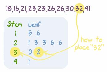
5 Reordering data: Stem and leaf plot
6 Reordering data: Box and whisker
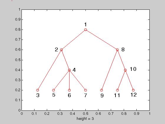
7 Tree plot

8 Parallel coordinate plot (R script on Github)


9 Self Organizing Map: Synapse (also an R plugin)
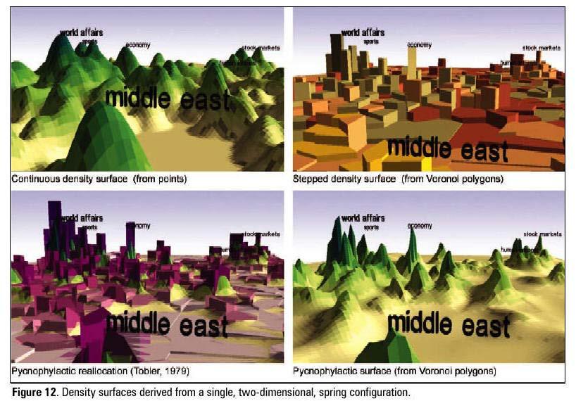
10 Spatialization
11 Radar plot: Cyclic time and multivariate

12 Tree plot: 2011 Census population

13 Medical research: Papers in 6 major journals, 6 time periods
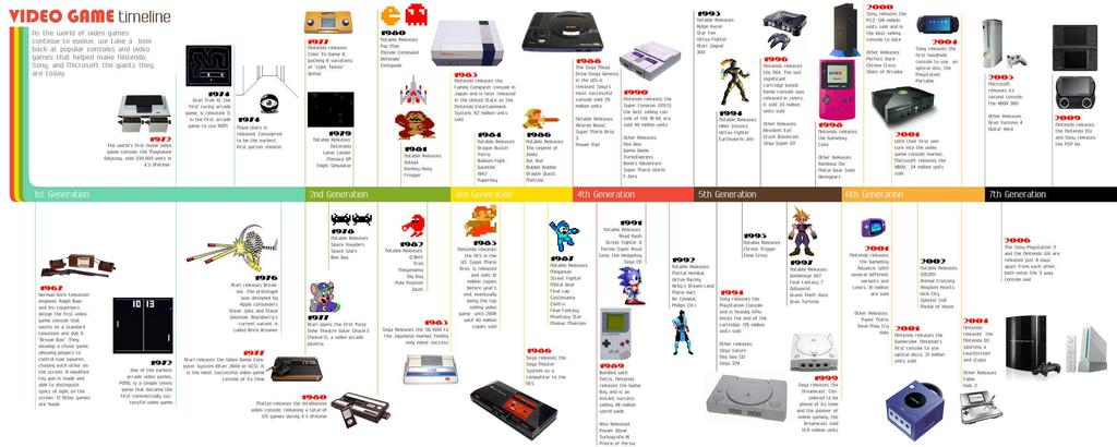
14 Timeline


15 Word clouds and tag maps

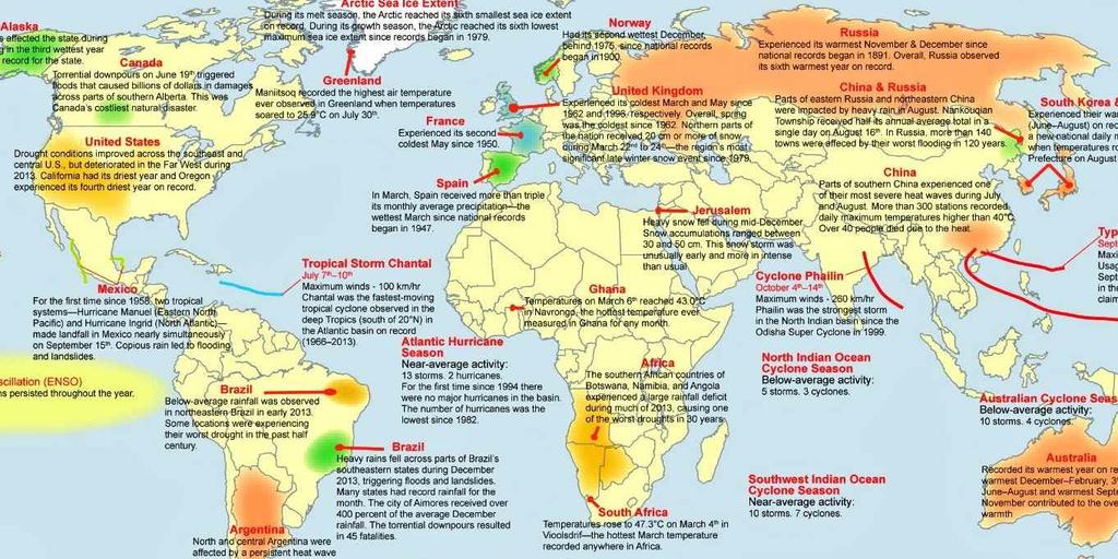
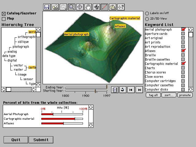
16 Annotated maps
17 Infographics

18 Multiple views and Linking

19 Example:

20 Brushing: loc.alize.us

21 Accessing content
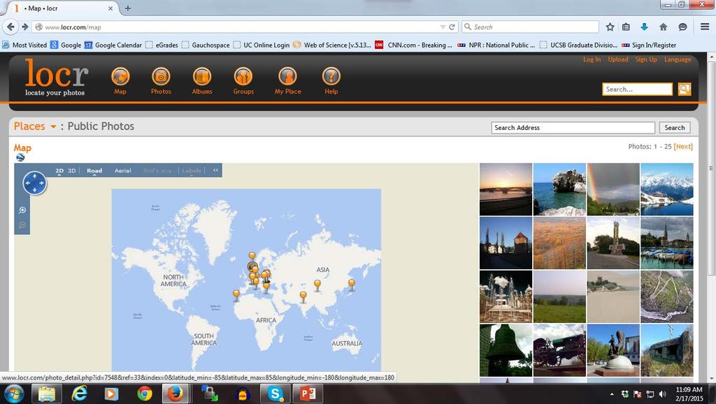
22 Locr.com
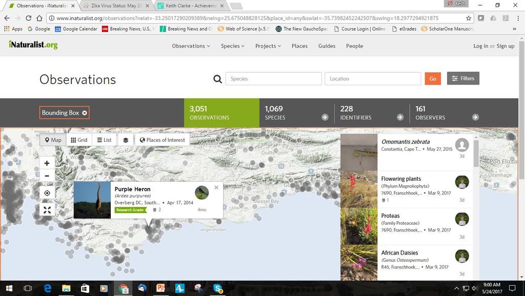
23 inaturalist.com

24 Including map views (SOMVIZ)

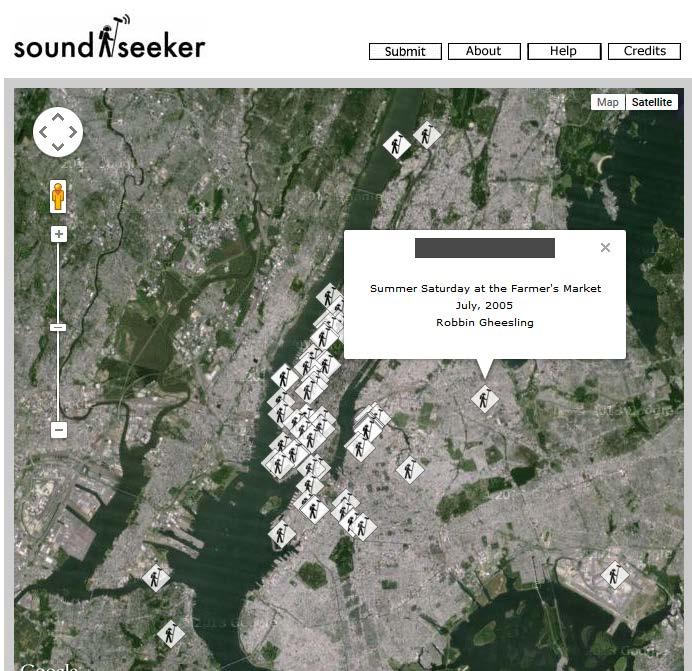
25 Sound mapping
 (2005).")
 Nelson Goodman's Languages of Art (1977)")
26 Visual Analytics "the science of analytical reasoning facilitated by interactive visual interfaces." James J. Thomas and Kristin A. Cook (Ed.) (2005). Illuminating the Path: The R&D Agenda for Visual Analytics National Visualization and Analytics Center. p.4. Theories of visualization include: [3] Jacques Bertin's Semiology of Graphics (1967) Nelson Goodman's Languages of Art (1977) Jock D. Mackinlay's Automated design of optimal visualization (APT) (1986) Leland Wilkinson's Grammar of Graphics (1998)
27 What is visual analytics? Integrates new computational and theory-based tools with innovative interactive techniques and visual representations to enable humaninformation discourse Design of the tools and techniques is based on cognitive, design, and perceptual principles Form of reasoning: basis in visual (and spatial) thinking and reasoning Provides the reasoning framework upon which one can build both strategic and tactical visual analytics technologies for threat analysis, prevention, and response Central to the analyst s task of applying human judgments to reach conclusions from a combination of evidence and assumptions
28 Some software & resources Tableau VisMaster Visual Analytics Mastering the Information Age VIS-SENSE Visual Analytic Representation of Large datasets for Enhancing Network Security SPP - Scalable Visual Analytics Visual Analytics Digital Library (VADL) GeoAnalytics.net - GeoSpatial Visual Analytics, ICA Commission on GeoVizualisation flowingdata.com, visualization and statistics blog Quadrigram, a visual programming language for visual analytics Most statistical analysis packages: R, SAS, MATLAB etc.

29 Infoviz.org


30 Study by Sandia National Labs Open Source software for Visual Analytics


31 Comparison of Open Source Visual Analytics Toolkits John R. Hargera, and Patricia J. Crossnoa Proceedings of the SPIE Conference on Visualization and Data Analysis, 2012

32 Information Visualization & Visual Analytics, Pacific Northwest National Laboratory


33 Penn State GeoVista Studio

34 ESRI Story Maps

35 Hip Hop interactive story map Geography of Hip-Hop By Esri Story Maps team / Katya Deveory 2017

36 CMIP5: Global change explorer (LLNL)
37


38 NSF: Annual Visualization Challenge From icefield to ocean Credit: Kristin Timm, Shad O'Neel, Allison Bidlack and Eran Hood Goddard Space Flight Center's NASA Visualization Group; Helen-Nicole Kostis, Project Manager
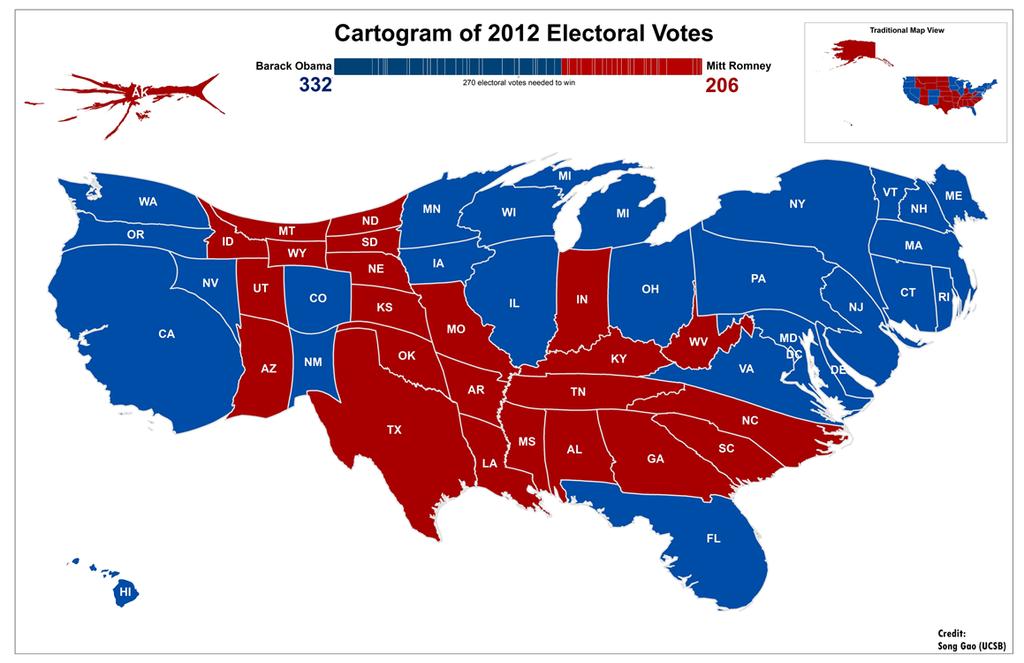
39 Cartograms: Animation at:

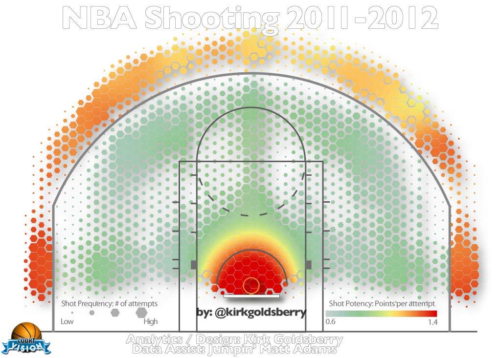
40 Information Viz and Social Media
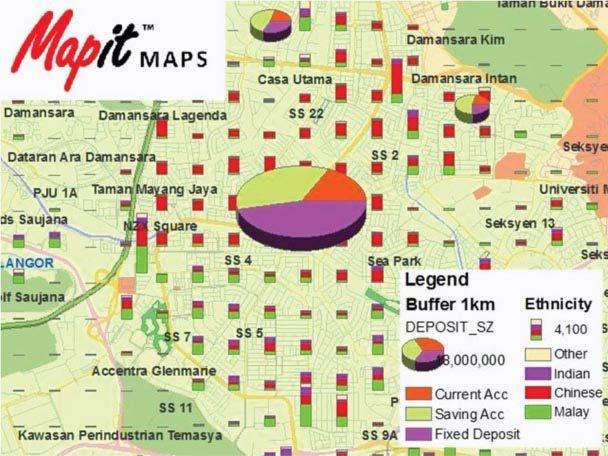
41 Business GeoGraphics
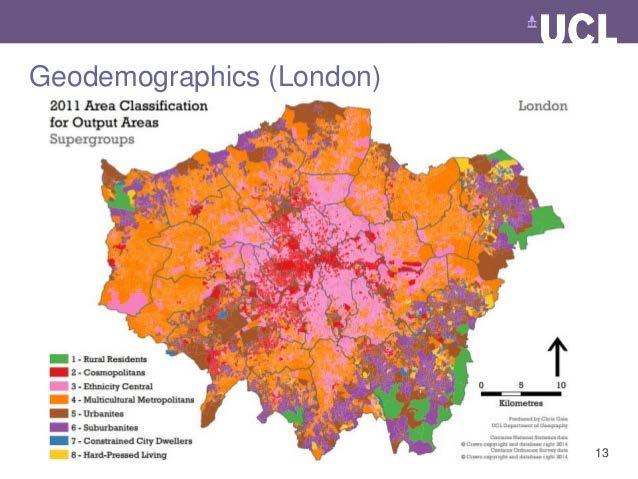
42 Business Analytics--Geodemographics
43 Some sources IEEE Visual Analytics Science and Technology (VAST) Conference InfoViz Annual Conference Now IEEE Visual Analytics Science and Technology (VAST), IEEE Information Visualization (InfoVis), IEEE Scientific Visualization (SciVis) Visual Analytics Digital Library (VADL) GeoAnalytics.net - GeoSpatial Visual Analytics, ICA Commission on GeoVizualisation flowingdata.com, visualization and statistics blog Quadrigram, a visual programming language for visual analytics Middlesex University Interaction Design Centre weblog, visual analytics blog and resources Information Visualization & Visual Analytics, Pacific Northwest National Laboratory
44 Summary Data exploration: many new means to show patterns in data Show pattern, change in time and space Many software solutions Pretty much all cartography and GIS fits into viz Infoviz, geoviz, information graphics, visual analytics Possible to use geospatial methods on non-spatial data Visual analytics focus on interaction Building methods and theory of a discipline
Geog183: Cartographic Design and Geovisualization Spring Quarter 2018 Lecture 3: Thematic cartography, geovisualization and visual analytics
 Geog183: Cartographic Design and Geovisualization Spring Quarter 2018 Lecture 3: Thematic cartography, geovisualization and visual analytics General Purpose or Reference Cartography Maps showing generic
Topic 2: New Directions in Distributed Geovisualization. Alan M. MacEachren
 Topic 2: New Directions in Distributed Geovisualization Alan M. MacEachren GeoVISTA Center Department of Geography, Penn State & International Cartographic Association Commission on Visualization & Virtual
Web 2.0, map production & publishing and geospatial information dissemenation
 Web 2.0, map production & publishing and geospatial information dissemenation Professor William Cartwright President, International Cartographic Association William Cartwright 18th UNRCC for Asia and the
The Relevance of Cartography. Dubai 2015, Georg Gartner
 The Relevance of Cartography Dubai 2015, Georg Gartner Where are we? Data! Data? We are not short of data Technologies! Technologies? We are not short of technologies Data-driven and technology-driven
What is GIS? G: Geographic, Geospatial, Geo
 GEOG 488/588: GIS I Introduction Instructor: Geoffrey Duh TA: David Graves What is GIS? G: Geographic, Geospatial, Geo Alternatives: Spatial Information Systems, Land Information Systems Geography diverse
THEMATIC CARTOGRAPHY AND GEOVISUALIZATION PDF
 THEMATIC CARTOGRAPHY AND GEOVISUALIZATION PDF ==> Download: THEMATIC CARTOGRAPHY AND GEOVISUALIZATION PDF THEMATIC CARTOGRAPHY AND GEOVISUALIZATION PDF - Are you searching for Thematic Cartography And
FIRE DEPARMENT SANTA CLARA COUNTY
 DEFINITION FIRE DEPARMENT SANTA CLARA COUNTY GEOGRAPHIC INFORMATION SYSTEM (GIS) ANALYST Under the direction of the Information Technology Officer, the GIS Analyst provides geo-spatial strategic planning,
Combing Open-Source Programming Languages with GIS for Spatial Data Science. Maja Kalinic Master s Thesis
 Combing Open-Source Programming Languages with GIS for Spatial Data Science Maja Kalinic Master s Thesis International Master of Science in Cartography 14.09.2017 Outline Introduction and Motivation Research
Data Visualization (CSE 578) About this Course. Learning Outcomes. Projects
 About this Course. Learning Outcomes. Projects") (CSE 578) Note: Below outline is subject to modifications and updates. About this Course Visual representations generated by statistical models help us to make sense of large, complex datasets through
(CSE 578) Note: Below outline is subject to modifications and updates. About this Course Visual representations generated by statistical models help us to make sense of large, complex datasets through
BACHELOR OF ARTS GEOGRAPHY
 BACHEL OF ARTS General Education Categories (4-5 credits total) FYS First Year Seminar W-I Written Communication - Level I OC Oral Communication PGR Personal Growth & Responsibility CEA Creative Expression
Maps and sustainability
 Maps and sustainability The International Map Year [ mapyear.org ] Menno-Jan Kraak Maps Cartography and maps A map is a visual representation of an environment maps tell stories maps invite maps show patterns
Geographic Analysis of Linguistically Encoded Movement Patterns A Contextualized Perspective
 Geographic Analysis of Linguistically Encoded Movement Patterns A Contextualized Perspective Alexander Klippel 1, Alan MacEachren 1, Prasenjit Mitra 2, Ian Turton 1, Xiao Zhang 2, Anuj Jaiswal 2, Kean
Geospatial Intelligence
 Geospatial Intelligence Geospatial analysis has existed as long as humans have made and studied maps but its importance to the intelligence community has skyrocketed in the past several years, with Unmanned
CSC2524 L0101 TOPICS IN INTERACTIVE COMPUTING: INFORMATION VISUALISATION DATA MODELS. Fanny CHEVALIER
 CSC2524 L0101 TOPICS IN INTERACTIVE COMPUTING: INFORMATION VISUALISATION DATA MODELS Fanny CHEVALIER VISUALISATION DATA MODELS AND REPRESENTATIONS Source: http://www.hotbutterstudio.com/ THE INFOVIS
BACHELOR OF GEOINFORMATION TECHNOLOGY (NQF Level 7) Programme Aims/Purpose:
 Programme Aims/Purpose:") BACHELOR OF GEOINFORMATION TECHNOLOGY ( Level 7) Programme Aims/Purpose: The Bachelor of Geoinformation Technology aims to provide a skilful and competent labour force for the growing Systems (GIS) industry
BACHELOR OF GEOINFORMATION TECHNOLOGY ( Level 7) Programme Aims/Purpose: The Bachelor of Geoinformation Technology aims to provide a skilful and competent labour force for the growing Systems (GIS) industry
Highlighting in Geovisualization. Anthony C. Robinson
 Highlighting in Geovisualization Anthony C. Robinson ABSTRACT: Coordinated view geovisualizations allow users to interactively pick and attend to data observations across multiple views. This is frequently
Cartographic and Geospatial Futures
 Cartographic and Geospatial Futures 1. Web Cartography, WebGIS, & Virtual Globes--New Roles for Maps, GIS, and GIS professionals 2. Map Mashups, the Neo Neo-geography Movement, & Crowd-sourcing Geospatial
Introduction to GIS (GEOG 401) Spring 2014, 3 credit hours
 Spring 2014, 3 credit hours") Introduction to GIS (GEOG 401) Spring 2014, 3 credit hours Instructors: Guangxing Wang, Ph.D. Email: gxwang@siu.edu Phone: (618) 453-6017 Office: 4442 Faner Hall Office hours: M& W&F 9:00am-11:00am or
Introduction to GIS (GEOG 401) Spring 2014, 3 credit hours Instructors: Guangxing Wang, Ph.D. Email: gxwang@siu.edu Phone: (618) 453-6017 Office: 4442 Faner Hall Office hours: M& W&F 9:00am-11:00am or
The 2010 Census Successful Because of GIS
 The 2010 Census Successful Because of GIS Timothy F. Trainor Chief, Geography Division, U.S. Census Bureau Vice President, International Cartographic Association Establishing the Framework of the Operation
ROLE ICA VE KARTOGRAFIE.
 ROLE ICA VE KARTOGRAFIE Is Cartography s there is quite some confusion about the status, relevance and importance of Cartography w business debates amongst major software companies, in mass market applications
Changes in Esri GIS, practical ways to be ready for the future
 Changes in Esri GIS, practical ways to be ready for the future John Sharrard, Esri April 16, 2015 The only thing that is constant is change. Heraclitus, ca. 500 B.C. My story (of experiencing change) Changes
Key Questions and Issues. What is GIS? GIS is to geographic analysis as: What is GIS? 9/3/2013. GEO 327G/386G, UT Austin 1
 What is GIS? Key Questions and Issues Geology Elevation Transportation Hydrography Imagery What is GIS? What are the applications of GIS? How is the real world represented in GIS? What analyses can GIS
Welcome! Power BI User Group (PUG) Copenhagen
 Copenhagen") Welcome! Power BI User Group (PUG) Copenhagen Making Maps in Power BI Andrea Martorana Tusa BI Specialist Welcome to Making maps in Power BI Who am I? First name: Andrea. Last name: Martorana Tusa. Italian,
Welcome! Power BI User Group (PUG) Copenhagen Making Maps in Power BI Andrea Martorana Tusa BI Specialist Welcome to Making maps in Power BI Who am I? First name: Andrea. Last name: Martorana Tusa. Italian,
Research Group Cartography
 Research Group Cartography Research Group Cartography Towards supporting wayfinding LBS components 1. Mobile devices 2. Communication Network 3. Positioning Component 4. Service and Application Provider
GIS Visualization: A Library s Pursuit Towards Creative and Innovative Research
 GIS Visualization: A Library s Pursuit Towards Creative and Innovative Research Justin B. Sorensen J. Willard Marriott Library University of Utah justin.sorensen@utah.edu Abstract As emerging technologies
GeoTime Visualization of RFID Providing Global Visibility of the DoD Supply Chain
 GeoTime Visualization of RFID Providing Global Visibility of the DoD Supply Chain David Shuping (FC Business Systems) and William Wright (Oculus Info, Inc.) Abstract The use of Radio Frequency Identification
8/27/2015 M. Helper, U. Texas, Austin
 Slide 1 What is GIS? Geology Transportation Hydrography Elevation Imagery Geo327G/386G UT Austin 1 Slide 2 Key Questions and Issues What is GIS? What are the applications of GIS? How is the real world
Professional Masters Program in Geographic Information Systems Program Description
 University of Washington Department of Geography together with Professional and Continuing Education Professional Masters Program in Geographic Information Systems Program Description The Professional
https://sites.google.com/a/pdx.edu/gis-2-applications/home
 Page 1 of 5 GIS 2: APPLICATIONS Search this site GEOG 492/592: GIS 2 Syllabus Academic Guidelines Rubrics Presentation Rubric Project Poster Project Proposal Syllabus (PDF) Sitemap GEOG 492/592: GIS 2
Belfairs Academy GEOGRAPHY Fundamentals Map
 YEAR 12 Fundamentals Unit 1 Contemporary Urban Places Urbanisation Urbanisation and its importance in human affairs. Global patterns of urbanisation since 1945. Urbanisation, suburbanisation, counter-urbanisation,
Problems and Challenges
 2018 Esri Petroleum GIS Conference Problems and Challenges May 9 10, 2018 Houston, Texas George R. Brown Convention Center Disunity of drawing standards and format Large amount of work in Cartography,
A Framework for Visualization of Geospatial Information in 3D Virtual City Environment for Disaster Risk Management
 A Framework for Visualization of Geospatial Information in 3D Virtual City Environment for Disaster Risk Management Asli Yilmaz 1, Sebnem Duzgun 2 1 Geodetic and Geographic Information Technologies, Middle
Practical applications of GPS surveying
 Practical applications of GPS surveying WHO WILL TEACH THE COURSE? Kurt L. Feigl, Ph.D., Associate Professor, Department of Geology and Geophysics feigl@geology.wisc.edu CAPSULE STATEMENT OF COURSE CONTENT
CERTIFICATE PROGRAM IN
 CERTIFICATE PROGRAM IN GEOGRAPHIC INFORMATION SCIENCE Department of Geography University of Utah 260 S. Central Campus Dr., Rm 270 Salt Lake City, UT 84112-9155 801-581-8218 (voice); 801-581-8219 (fax)
TRAITS to put you on the map
 TRAITS to put you on the map Know what s where See the big picture Connect the dots Get it right Use where to say WOW Look around Spread the word Make it yours Finding your way Location is associated with
Introduction to ArcGIS Maps for Office. Greg Ponto Scott Ball
 Introduction to ArcGIS Maps for Office Greg Ponto Scott Ball Agenda What is Maps for Office? Platform overview What are Apps for the Office? ArcGIS Maps for Office features - Visualization - Geoenrichment
GEOG 508 GEOGRAPHIC INFORMATION SYSTEMS I KANSAS STATE UNIVERSITY DEPARTMENT OF GEOGRAPHY FALL SEMESTER, 2002
 GEOG 508 GEOGRAPHIC INFORMATION SYSTEMS I KANSAS STATE UNIVERSITY DEPARTMENT OF GEOGRAPHY FALL SEMESTER, 2002 Course Reference #: 13210 Meeting Time: TU 2:05pm - 3:20 pm Meeting Place: Ackert 221 Remote
Alan M. MacEachren and Menno-Jan Kraak 1
 Research Challenges in Geovisualization Alan M. MacEachren and Menno-Jan Kraak 1 This special issue of Cartography and Geographic Information Science presents the results of an international collaboration
GTECH 380/722 Analytical and Computer Cartography Hunter College, CUNY Department of Geography
 GTECH 380/722 Analytical and Computer Cartography Hunter College, CUNY Department of Geography Spring 2010 Wednesdays 5:35PM to 9:15PM Instructor: Doug Williamson, PhD Email: Douglas.Williamson@hunter.cuny.edu
GIS at UCAR. The evolution of NCAR s GIS Initiative. Olga Wilhelmi ESIG-NCAR Unidata Workshop 24 June, 2003
 GIS at UCAR The evolution of NCAR s GIS Initiative Olga Wilhelmi ESIG-NCAR Unidata Workshop 24 June, 2003 Why GIS? z z z z More questions about various climatological, meteorological, hydrological and
Geovisualization for knowledge construction and decision-support
 Geovisualization for knowledge construction and decision-support Alan M. MacEachren Mark Gahegan William Pike Isaac Brewer GeoVISTA Center and Department of Geography The Pennsylvania State University
An evolving cognitive-semiotic approach to geographic visualization and knowledge construction
 An evolving cognitive-semiotic approach to geographic visualization and knowledge construction Alan M. MacEachren GeoVISTA Center, www.geovista.psu.edu 302 Walker, Department of Geography Penn State University
Joanne N. Halls, PhD Dept. of Geography & Geology David Kirk Information Technology Services
 Joanne N. Halls, PhD Dept. of Geography & Geology David Kirk Information Technology Services Geographic Information Systems manage and analyze data to solve spatial problems. Real World Abstraction Analysis
METHODS FOR STATISTICS
 DYNAMIC CARTOGRAPHIC METHODS FOR VISUALIZATION OF HEALTH STATISTICS Radim Stampach M.Sc. Assoc. Prof. Milan Konecny Ph.D. Petr Kubicek Ph.D. Laboratory on Geoinformatics and Cartography, Department of
State and National Standard Correlations NGS, NCGIA, ESRI, MCHE
 GEOGRAPHIC INFORMATION SYSTEMS (GIS) COURSE DESCRIPTION SS000044 (1 st or 2 nd Sem.) GEOGRAPHIC INFORMATION SYSTEMS (11, 12) ½ Unit Prerequisite: None This course is an introduction to Geographic Information
Snowden Cartography 1 GEOG 315:001 Cartography Thursdays 4:00 6:30PM F375 Fall 2010 Dr. Snowden Course Description
 Snowden Cartography 1 www.drksnowden.com GEOG 315:001 Cartography Thursdays 4:00 6:30PM F375 Fall 2010 Dr. Snowden Course Description Principles and theory of basic map design, layout, and communication.
Statistical perspectives on spatial social science
 Statistical perspectives on spatial social science Discussion Sarah Nusser (nusser@iastate.edu) Center for Survey Statistics and Methodology Department of Statistics Iowa State University Morris Hansen
GIS PORTFOLIO MOHAMED MAGDY MOHAMED HUSSAIN GIS ENGINEER. UWF GIS ONLINE CERTIFICATE GIS Internship (GIS4944)
") 2012 GIS PORTFOLIO MOHAMED MAGDY MOHAMED HUSSAIN GIS ENGINEER UWF GIS ONLINE CERTIFICATE GIS Internship (GIS4944) Portfolio Table of Contents Subject... Page Personal statement/mission/philosophy... 1
2012 GIS PORTFOLIO MOHAMED MAGDY MOHAMED HUSSAIN GIS ENGINEER UWF GIS ONLINE CERTIFICATE GIS Internship (GIS4944) Portfolio Table of Contents Subject... Page Personal statement/mission/philosophy... 1
Workshop and Session Descriptions
 MONDAY, SEPTEMBER 14 Workshops (Full-day) Workshop and Session Descriptions 1. Bridging the surveyed gap: How land surveying data works with GIS GIS professionals use a myriad of data to construct their
ArcGIS for Desktop. ArcGIS for Desktop is the primary authoring tool for the ArcGIS platform.
 ArcGIS for Desktop ArcGIS for Desktop ArcGIS for Desktop is the primary authoring tool for the ArcGIS platform. Beyond showing your data as points on a map, ArcGIS for Desktop gives you the power to manage
Bachelor of Geospatial Science The University of the South Pacific
 Bachelor of Geospatial Science The University of the South Pacific Geospatial Science Unit School of Geography, Earth Science and Environment Aleen Elisha Prasad Inesha Manzini Semisi Ketenilagi Geospatial
2013 AND 2025 THE FUTURE OF GIS
 THE FUTURE OF GIS 2013 AND 2025 What is the state of geospatial computing today? What are the issues today? Unresolved problems What will geospatial computing be like in 2025? What issues will be of concern
Visualization of Origin- Destination Commuter Flow Using CTPP Data and ArcGIS
 Visualization of Origin- Destination Commuter Flow Using CTPP Data and ArcGIS Research & Analysis Department Southern California Association of Governments 2015 ESRI User Conference l July 23, 2015 l San
GIS Institute Center for Geographic Analysis
 GIS Institute Center for Geographic Analysis Welcome Intensive training in the application of GIS to research Collection, management, analysis, and communication of spatial data Topics include: data collection,
UNIT 4: USING ArcGIS. Instructor: Emmanuel K. Appiah-Adjei (PhD) Department of Geological Engineering KNUST, Kumasi
 Department of Geological Engineering KNUST, Kumasi") UNIT 4: USING ArcGIS Instructor: Emmanuel K. Appiah-Adjei (PhD) Department of Geological Engineering KNUST, Kumasi Getting to Know ArcGIS ArcGIS is an integrated collection of GIS software products ArcGIS
UNIT 4: USING ArcGIS Instructor: Emmanuel K. Appiah-Adjei (PhD) Department of Geological Engineering KNUST, Kumasi Getting to Know ArcGIS ArcGIS is an integrated collection of GIS software products ArcGIS
Future Proofing the Provision of Geoinformation: Emerging Technologies
 Future Proofing the Provision of Geoinformation: Emerging Technologies An Exchange Forum with the Geospatial Industry William Cartwright Chair JBGIS Second High Level Forum on Global Geospatial Information
WHAT YOU WILL LEARN TODAY
 WHAT YOU WILL LEARN TODAY Overview of the new QGIS Academy Curriculum Background on curriculum development Curriculum alignment with national standards Description of the five GIS courses Details of the
Department Of Geography. MSc Applied GIS.
 Department Of Geography. MSc Applied GIS. This is a really exciting time to be in GIS, with new tools and new software allowing the application of GIS techniques to an ever-increasing range of fields.
DATA SCIENCE SIMPLIFIED USING ARCGIS API FOR PYTHON
 DATA SCIENCE SIMPLIFIED USING ARCGIS API FOR PYTHON LEAD CONSULTANT, INFOSYS LIMITED SEZ Survey No. 41 (pt) 50 (pt), Singapore Township PO, Ghatkesar Mandal, Hyderabad, Telengana 500088 Word Limit of the
Ladder versus star: Comparing two approaches for generalizing hydrologic flowline data across multiple scales. Kevin Ross
 Ladder versus star: Comparing two approaches for generalizing hydrologic flowline data across multiple scales Kevin Ross kevin.ross@psu.edu Paper for Seminar in Cartography: Multiscale Hydrography GEOG
Geovisualization. CSISS Workshop, Ann Arbor. May Mark Gahegan, GeoVISTA Center, Department of Geography, Penn State university
 Geovisualization CSISS Workshop, Ann Arbor. May 2001 Mark Gahegan, GeoVISTA Center, Department of Geography, Penn State university Introduction Visualization is an emerging science that draws from a rich
ArcGIS is Advancing. Both Contributing and Integrating many new Innovations. IoT. Smart Mapping. Smart Devices Advanced Analytics
 ArcGIS is Advancing IoT Smart Devices Advanced Analytics Smart Mapping Real-Time Faster Computing Web Services Crowdsourcing Sensor Networks Both Contributing and Integrating many new Innovations ArcGIS
Cartography as an Academic Field: A Lost Opportunity or a New Beginning?
 Cartography as an Academic Field: A Lost Opportunity or a New Beginning? Alan M. MacEachren Department of Geography, The Pennsylvania State University Abstract: This short essay considers the fact that
GIS Test Drive What a Geographic Information System Is and What it Can Do. Alison Davis-Holland
 GIS Test Drive What a Geographic Information System Is and What it Can Do Alison Davis-Holland adavisholland@gmail.com WHO AM I? Geospatial Analyst M.S. in Geographic and Cartographic Sciences Use GIS
Lecture 2. A Review: Geographic Information Systems & ArcGIS Basics
 Lecture 2 A Review: Geographic Information Systems & ArcGIS Basics GIS Overview Types of Maps Symbolization & Classification Map Elements GIS Data Models Coordinate Systems and Projections Scale Geodatabases
Geospatial Intelligence
 Geospatial Intelligence Geospatial analysis has existed as long as humans have made and studied maps but its importance to the intelligence community has skyrocketed in the past several years, with Unmanned
How a Media Organization Tackles the. Challenge Opportunity. Digital Gazetteer Workshop December 8, 2006
 A Case-Study-In-Process: How a Media Organization Tackles the Georeferencing Challenge Opportunity Digital Gazetteer Workshop December 8, 2006 to increase and diffuse geographic knowledge 1888 to 2006:
Geographical Information System (GIS) Prof. A. K. Gosain
 Prof. A. K. Gosain") Geographical Information System (GIS) Prof. A. K. Gosain gosain@civil.iitd.ernet.in Definition of GIS GIS - Geographic Information System or a particular information system applied to geographical data
Geographical Information System (GIS) Prof. A. K. Gosain gosain@civil.iitd.ernet.in Definition of GIS GIS - Geographic Information System or a particular information system applied to geographical data
Evolution or Devolution of Cartographic Education?
 Evolution or Devolution of Cartographic Education? Transformations in Teaching Cartographic Concepts and Techniques Aileen Buckley Cartographic Researcher, ESRI, Inc. abuckley@esri.com Terminology UCGIS*
Among various open-source GIS programs, QGIS can be the best suitable option which can be used across partners for reasons outlined below.
 Comparison of Geographic Information Systems (GIS) software As of January 2018, WHO has reached an agreement with ESRI (an international supplier of GIS software) for an unlimited use of ArcGIS Desktop
Spatial Analysis and Modeling (GIST 4302/5302) Guofeng Cao Department of Geosciences Texas Tech University
 Guofeng Cao Department of Geosciences Texas Tech University") Spatial Analysis and Modeling (GIST 4302/5302) Guofeng Cao Department of Geosciences Texas Tech University TTU Graduate Certificate Geographic Information Science and Technology (GIST) 3 Core Courses and
Spatial Analysis and Modeling (GIST 4302/5302) Guofeng Cao Department of Geosciences Texas Tech University TTU Graduate Certificate Geographic Information Science and Technology (GIST) 3 Core Courses and
Seeing inside the cloud: some ways to map the Internet
 Seeing inside the cloud: some ways to map the Internet Martin Dodge www.cybergeography.org Centre for Advanced Spatial Analysis University College London / Media Art Net Lectures: Mapping, ZKM, Karlsruhe
CARTOGRAPHY in a Web World
 CARTOGRAPHY in a Web World SENSE Research Cluster XIII meeting: Concepts and tools for spatial data visualization BAREND KÖBBEN kobben@itc.nl b.j.kobben@utwente.nl Agenda Short introduction to ITC and
Introduction to the 176A labs and ArcGIS Purpose of the labs
 Introduction to the 176A labs and ArcGIS Purpose of the labs Acknowledgement: Slides by David Maidment, U Texas-Austin and Francisco Olivera (TAMU) Hands-on experience with a leading software package Introduction
WHAT YOU WILL LEARN TODAY
 WHAT YOU WILL LEARN TODAY Overview of the new GeoAcademy Curriculum Background on curriculum development Curriculum alignment with national standards Description of the five GIS courses Details of the
Maps, A GeoVisualization Domain Specific Language. Lucía Gómez Álvarez
 School of Computing FACULTY OF ENGINEERING Maps, A GeoVisualization Domain Specific Language Lucía Gómez Álvarez Submitted in accordance with the requirements for the degree of MSc on Advanced Computer
Outline. Geographic Information Analysis & Spatial Data. Spatial Analysis is a Key Term. Lecture #1
 Geographic Information Analysis & Spatial Data Lecture #1 Outline Introduction Spatial Data Types: Objects vs. Fields Scale of Attribute Measures GIS and Spatial Analysis Spatial Analysis is a Key Term
Geog418: Introduction to GIS Fall 2011 Course Syllabus. Textbook: Introduction to Geographic Information Systems edited by Chang (6th ed.
 Geog418: Introduction to GIS Fall 2011 Course Syllabus AH 1320 3:30 4:45 p.m.tr Instructor: Dr. Shunfu Hu Office: AH1413 Telephone 650-2281 Office hours: 10:00 11:00 a.m. TR or by appointment (shu@siue.edu)
ANTHONY C. ROBINSON 121 Beagle Run Court State College, PA (814)
") ANTHONY C. ROBINSON 121 Beagle Run Court State College, PA 16801 (814) 861-8758 arobinson@psu.edu http://www.personal.psu.edu/acr181/ EDUCATION Doctor of Philosophy, Geography (2008) The Pennsylvania State
ANTHONY C. ROBINSON 121 Beagle Run Court State College, PA 16801 (814) 861-8758 arobinson@psu.edu http://www.personal.psu.edu/acr181/ EDUCATION Doctor of Philosophy, Geography (2008) The Pennsylvania State
Evaluating the usability of visualization methods in an exploratory geovisualization environment
 International Journal of Geographical Information Science Vol. 20, No. 4, April 2006, 425 448 Research Article Evaluating the usability of visualization methods in an exploratory geovisualization environment
Alexander Klippel and Chris Weaver. GeoVISTA Center, Department of Geography The Pennsylvania State University, PA, USA
 Analyzing Behavioral Similarity Measures in Linguistic and Non-linguistic Conceptualization of Spatial Information and the Question of Individual Differences Alexander Klippel and Chris Weaver GeoVISTA
1. Omit Human and Physical Geography electives (6 credits) 2. Add GEOG 677:Internet GIS (3 credits) 3. Add 3 credits to GEOG 797: Final Project
 2. Add GEOG 677:Internet GIS (3 credits) 3. Add 3 credits to GEOG 797: Final Project") The Department of Geography and the Office of Professional Studies propose to modify the Master of Professional Studies in Geospatial Information Sciences (GIS) as follows: 1. Omit Human and Physical Geography
The Department of Geography and the Office of Professional Studies propose to modify the Master of Professional Studies in Geospatial Information Sciences (GIS) as follows: 1. Omit Human and Physical Geography
Basics of GIS reviewed
 Basics of GIS reviewed Martin Breunig Karlsruhe Institute of Technology martin.breunig@kit.edu GEODETIC INSTITUTE, DEPARTMENT OF CIVIL ENGINEERING, GEO AND ENVIRONMENTAL SCIENCES, CHAIR IN GEOINFORMATICS
University of Lusaka
 University of Lusaka BSPH 315 Health Mapping & GIS Topic: Background of GIS Content: 1. Aim of the course 2. What do you know about GIS? 3. Difference between geographic data and geographic information
Performing Advanced Cartography with Esri Production Mapping
 Esri International User Conference San Diego, California Technical Workshops July 25, 2012 Performing Advanced Cartography with Esri Production Mapping Tania Pal & Madhura Phaterpekar Agenda Outline generic
GRADUATE CERTIFICATE PROGRAM
 GRADUATE CERTIFICATE PROGRAM GEOGRAPHIC INFORMATION SCIENCES Department of Geography University of North Carolina Chapel Hill Conghe Song, Director csong @email.unc.edu 919-843-4764 (voice) 919-962-1537
MAKING MAPS Cartographic Design & Principles Winter 2018
 MAKING MAPS Cartographic Design & Principles Winter 2018 Cartography the art, science, and technology of making maps, together with their study as scientific documents and works of art - The International
Technical Drafting, Geographic Information Systems and Computer- Based Cartography
 Technical Drafting, Geographic Information Systems and Computer- Based Cartography Project-Specific and Regional Resource Mapping Services Geographic Information Systems - Spatial Analysis Terrestrial
Switching to AQA from Edexcel: Draft Geography AS and A-level (teaching from September 2016)
") Switching to AQA from Edexcel: Draft Geography AS and A-level (teaching from September 2016) If you are thinking of switching from OCR to AQA (from September 2016), this resource is an easy reference guide.
Switching to AQA from Edexcel: Draft Geography AS and A-level (teaching from September 2016) If you are thinking of switching from OCR to AQA (from September 2016), this resource is an easy reference guide.
Visualization of Commuter Flow Using CTPP Data and GIS
 Visualization of Commuter Flow Using CTPP Data and GIS Research & Analysis Department Southern California Association of Governments 2015 ESRI User Conference l July 23, 2015 l San Diego, CA Jung Seo,
Cartography and Children Commission: Proposals for the next 4 years
 International Cartographic Association Cartography and Children Commission: Proposals for the next 4 years José Jesús Reyes Nuñez Eötvös Loránd University Dept. of Cartography and Geoinformatics Budapest,
NATO Headquarters The Situation Center GIS experience.
 NATO Headquarters The Situation Center GIS experience. Abstract Recently, the dynamic capability of responding to a major world crisis with comprehensive in-depth information has become a crucial aspect
A GIS helps you answer questions and solve problems by looking at your data in a way that is quickly understood and easily shared.
 WHAT IS GIS? A geographic information system (GIS) integrates hardware, software, and data for capturing, managing, analyzing, and displaying all forms of geographically referenced information. GIS allows
GENERALIZATION IN THE NEW GENERATION OF GIS. Dan Lee ESRI, Inc. 380 New York Street Redlands, CA USA Fax:
 GENERALIZATION IN THE NEW GENERATION OF GIS Dan Lee ESRI, Inc. 380 New York Street Redlands, CA 92373 USA dlee@esri.com Fax: 909-793-5953 Abstract In the research and development of automated map generalization,
Point data in mashups: moving away from pushpins in maps
 Point data in mashups: moving away from pushpins in maps Aidan Slingsby, Jason Dykes, Jo Wood gicentre, City University London Department of Information Science, City University London, Northampton Square,
Introduction to the 176A labs and ArcGIS
 Introduction to the 176A labs and ArcGIS Acknowledgement: Slides by David Maidment, U Texas-Austin and Francisco Olivera (TAMU) Purpose of the labs Hands-on experience with one software pakage Introduction
Introducing Spatial IQ
 Introducing Spatial IQ TM A Managed Services Approach to Enterprise GIS Let AppGeo be your bridge to the future. The Magic of Location AppGeo believes that information plus geography changes how we work
MAP SYMBOL BREWER A NEW APPROACH FOR A CARTOGRAPHIC MAP SYMBOL GENERATOR
 MAP SYMBOL BREWER A NEW APPROACH FOR A CARTOGRAPHIC MAP SYMBOL GENERATOR Olaf Schnabel Institute of Cartography, Swiss Federal Institute of Technology (ETH) CH-8093 Zurich, Switzerland schnabel@karto.baug.ethz.ch
Canadian Historical GIS Partnership Development: Taking Steps for Historical Mapping in Canada
 Canadian Historical GIS Partnership Development: Taking Steps for Historical Mapping in Canada Byron Moldofsky Manager, GIS and Cartography Office Department of Geography and Planning University of Toronto
Understanding Geographic Information System GIS
 Understanding Geographic Information System GIS What do we know about GIS? G eographic I nformation Maps Data S ystem Computerized What do we know about maps? Types of Maps (Familiar Examples) Street Maps