Heavy Metals in Water and Bottom Sediments of Odessa Region of the Black Sea
|
|
|
- Felicia Dixon
- 6 years ago
- Views:
Transcription
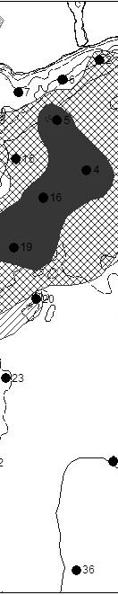
1 Journal of Shipping and Ocean Engineering 5 (2015) doi: / / D DAVID PUBLISHING Heavy Metals in Water and Bottom Sediments of Odessa Region of the Black Sea Sergey Yevgenevich Dyatlov Institute of Marine Biology, Ukrainian National Academy of Sciences, Odessa 65011, Ukraine Abstract: The paper presents the results of a comprehensive monitoring of the polygon: Odessa Region, north-western part of the Black Sea for the period It is shown that most of the copper and nickel is brought into the sea from the catchment area, and zinc and cadmium are mainly of the autochthonous origin. It is found that in 2010, after heavy rains, the area of bottom sediments contaminated by copper and nickel was increased. The main source of copper in the sea is vast vineyards. Keywords: Odessa Region of the Black Sea, water, bottom sediments, heavy metals, spatial distribution, GIS-based map technology. 1. Introduction The Odessa Region of the Black Sea is the coastal zone of the sea near the megalopolis of Odessa (Ukraine) with the area of about 2685 km 2. The maximum depth of the study area is 29 meters, minimum depth is 5 meters and the average depth is meters. 20 m isobath is located at a distance of 2-3 km from the coastline [1]. The main sources of pollution of the Odessa Region of the Black Sea are the major seaports (Odessa, Illychevsk, Yuzhnyi), waste water of three treatment plants, drainage and rain waters, flow waters from Danube, Dniestr and Dniepr with Southern Bug. Since 1988 to present (except ), Institute of Marine Biology has been carrying out the pollution monitoring in the Odessa Region of the Black Sea. The coastal location of the polygon and its relative shallowness cause high variability of water temperature and salinity and sediment resuspension, which often lead to secondary contamination of water [2, 3]. Our previous studies describe bottom sediments of the Odessa Region of the Black Sea (Fig. 1), and the variability of annual average content of heavy metals Corresponding author: Sergey Yevgenevich Dyatlov, Ph.D., research field: marine ecology. sergey.dyatlov@gmail.com. in bottom sediments from 1988 to the present time [4]. At the present time GIS-technology is increasingly being used for mapping the distribution of contaminants in sediments [5-7]. The goal of this work was the creation of the maps of heavy metals distribution in the Odessa Region of the Black Sea. 2. Methodology Schematic map of the study area is shown in Fig.1. Bottom sediment samples were collected from the scientific boat Sprut and delivered to the analytical laboratory of OB IBSS. The content of heavy metals (Cu, Zn, Ni, Cd) in sediments was determined using flame photometry. Maps of the spatial distribution of heavy metals in sediments were created using the software MapInfo, ArcGIS and Corel Draw. It was selected 12 samples of bottom sediments in 2009 and 17 samples in 2010 and In 2010, just prior to the expedition, there have been heavy rains across the north-western Black Sea, which led to a sharp increase copper and nickel in the sea [8]. In 2009, the precipitation was twice the norm, 740 mm. To assess the level of contamination of sediments with heavy metals, the excess over the background content of each of the metal was used of 1 (class 1 ), 2 (class 2 ) and 3δ (class 3 ) Schematic map of the study area is shown in Fig.3.
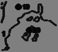
2 52 Heavy Metals in Water and Bottom Sediments of Odessa Region of the Black Sea Clayey silts Silts fine silt Coquina Pebble Oolitic limestoness coquina Coquina limestones Medium-fine sands Upper Pliocene sediments Lithological boundaries within the units Fig. 1 The map of bottom sediments of the Odessa Region of the Black Sea Cu Zn Ni Cd Fig. 2 Variability of annual average content of heavy metals in bottom sediments (mkg g 1 of solid matter) for the entire study period.
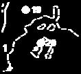
3 Heavy Metals in Water and Bottom Sediments of Odessa Region of the Black Sea 53 Fig. 3 A schematic map of the Odessa Region of north-west part of the Black Sea with sampling stations. Table 1 Average and maximum content of heavy metals in water of the Odessa Region of the Black Sea polygon for the period Surface horizon The dissolved form, mкg dm 3 Weighted form, mкg dm 3 Cu Zn Ni Cd Cu Zn Ni Cd Min Max cр Mean n=757 n=758 n=758 n=735 n=719 n=719 n=723 n=716 Bottom horizon min Max cр Mean n=765 n=764 n=764 n=743 n=718 n=720 n=715 n= Results Table 1 shows the average and maximum values of heavy metals over the entire study period. The minimum metal content is zero, except for the dissolved form of Cu in the bottom layer (0.02 mкg dm 3 ). The annual average concentration of heavy metals in sediments for the entire study period showed a tendency to decrease the content of Cu, Zn and Cd, and content of Ni to grow in In 2010 the content of heavy metals flowing from rain waters into the waters


 Fig.")

4 54 Heavy Metals in Water and Bottom Sediments of Odessa Region of the Black Sea (a) (b) Fig. 4 (c) (d) Spatial distribution: А: copper, B: zinc, C: nickel, D: cadmiumm in Odessa Region of the Black Sea in 2009.
5 Heavy Metals in Water and Bottom Sediments of Odessa Region of the Black Sea 55 (a) (b) (c) (d) Fig. 5 Spatial distribution: A:copper, B: zinc, C: nickel, D: cadmium in the Odessa Region of the Black Sea in 2010.
6 56 Heavy Metals in Water and Bottom Sediments of Odessa Region of the Black Sea (a) (b) (c) (d) Fig. 6 Spatial distribution: A: copper, B: zinc, C: nickel, D: cadmium in the Odessa Region of the Black Sea in 2011.
7 Heavy Metals in Water and Bottom Sediments of Odessa Region of the Black Sea 57 Table 1 Basic statistics of heavy metals in bottom sediments of the Odessa Region of the Black Sea 2009 г г г. min max mean lоg δ min max mean lоgδ min max mean lоgδ Сu Zn Ni Cd Table2 The area of the Odessa Region occupied by different classes of pollution (km 2 ). Classes of pollution Cu Zn Ni Cd 2009 I II III I II III г. I II III of the Odessa Region of the Black Sea has increased dramatically due to the precipitation of a record rainfall (740 mm per year, that was twice the norm) (Fig.1). Maps of the distribution of heavy metals in the Odessa Region of the Black Sea in are shown in Figs Basic statistics are given in Table 1. The sizes of areas occupied by I, II, and III classes of heavy metals are described in Table 2. As seen in Table 2, in 2010 the area occupied by three classes of pollution significantly increased compared to 2009: copper: 95.58%, zinc: 8.16%, nickel: 97.09% and cadmium: times. In 2011, the area occupied by three classes of contamination was 77.63% for copper, % for zinc, 54.12% for nickel and 88.78% for cadmium. 4. Conclusion Studies have shown that the nature of the spatial distribution of heavy metals is subject to inter-annual variability under the influence of various factors. It was found that copper and nickel arrive in the Odessa Region of the Black Sea mainly from the catchment area, and the distribution of zinc and nickel in sediments has autochthonous character. In addition, in 2010 the average copper content of the sediments of the Odessa Region of the Black Sea has increased 1.59 times compared to 2009 [8]. This is due to the flow of copper from the catchment area where there are the largest plantations of grapes in the South of Ukraine, for the protection of which against diseases copper preparation is widely used. References [1] Naukova Dumka Northwestern Part of the Black Sea: Biology and Ecology. (in Russian). [2] Dyatlov S.Ye Ecological and Toxicological Assessment of Marine Bottom Sediments. Vistnyk ONU (June) :88 95 (in Ukrainian). [3] Dyatlov S.Ye. and Tuchkovemko Yu.S Methods
8 58 Heavy Metals in Water and Bottom Sediments of Odessa Region of the Black Sea of Assessing the Role of Bottom Sediments as a Source of Secondary Pollution of the Water Environment Using Mathematical Modeling. Ecological Safety of Coastal and Shelf Areas and Comprehensive Utilization of Resources of the Shelf. (in Russian). [4] Dyatlov S.Ye. and Makovetskaya I.M Heavy Metals in Water and Bottom Sediments of Odessa Region of the Black Sea. Black Sea Challenges towards good environmental status: 4th Bi-annual Scientific Conference. (Abstract). [5] Fashchuk D.Ya Marine Ecological Geography: Theory and Experience. Springer, 431. [6] Сogan C.B., Todd B.J., Lawton P. and Noji T.T The role of Marine Habitat Mapping in Ecosystem-based Management. Ices Journal of Marine Science, V.66 (9). [7] Urbański J.F GIS-based Mapping of Benthic Habitats // Estuarine, Coastal and Shelf Habitats: [8] Dyatlov S.Ye., Petrosyan A.G., Pavlova Ye.A. and Secundyak L.Yu The Anomalously High Content of Copper in the Water and Sediments in Odessa Region NWBS Polygon in June Proceeding of Ternopil National Pedagogical University. [9] Dyatlov S.Ye, Chepizhko A.V. and Urdya V.A Interannual Variability of Heavy Metals in Water and Sediments Range Odessa Region North-West of the Black Sea. Ecological Safety of Coastal Shelf Zones and Comprehensive Use of Shelf Resources, issue 26, Vol.1,. (in Ukrainian). [10] Linnik P.M. and Zubenko I.B Role of Bottom Sediments in the Secondary Pollution of Aquatic Environments by Heavy-metal Compounds. Lakes and Reservoir: Research and Management, issue 5.
Environmental impact assessment study of the new offshore dumping sites for Šventoji port in Lithuania
 Environmental impact assessment study of the new offshore dumping sites for Šventoji port in Lithuania Introduction Summary In 2003 Lithuanian Ministry of Transport initiated the preparation of feasibility
Black Sea Data Access services
 Black Sea Data Access services PERSEUS Oceanographic Mediterranean and Black Sea Data Management Cast Data Base with vertical profiles of physical, chemical and biological data acquired with Bottle casts
Everglades National Park
 National Park Service U.S. Department of the Interior Water Budget, Climate Variability, and Predicting Salinity for Eastern Florida Bay Erik Stabenau and Kevin Kotun National Park Service Erik_Stabenau@nps.gov
Environmental Implications A Case Study
 Grain Size Variations and Its Environmental Implications A Case Study DR PURANDARA BEKAL SCIENTIST, NATIONAL INSTITUTE OF HYDROLOGY HARD ROCK REGIONAL CENTER HANUMAN NAGAR BELGAUM, KARNATAKA Particle Transport
EVALUATION OF MIGRATION OF HEAVY METAL CONTAINING SEDIMENT RESULTING FROM WATER EROSION USING A GEO- INFORMATION MODEL
 EVALUATION OF MIGRATION OF HEAVY METAL CONTAINING SEDIMENT RESULTING FROM WATER EROSION USING A GEO- INFORMATION MODEL János Tamás, Elza Kovács University of Debrecen, Centre of Agricultural Sciences Department
Metal fluxes from a sea deposit site for mine tailings
 Metal fluxes from a sea deposit site for mine tailings Morten T. Schaanning, Kuria Ndungu, Sigurd Øxnevad, Hilde C. Trannum Norwegian Institute for Water Research (NIVA) NRC Project ES32333 New knowledge
Spatial and Temporal distribution of metals in sediments of a tropical lagoon, SW coast of India: Environmental Indicators ABSTRACT
 Spatial and Temporal distribution of metals in sediments of a tropical lagoon, SW coast of India: Environmental Indicators C.P. Priju 1 and A.C. Narayana 2 * 1 Department of Marine Geology & Geophysics
CHAPTER 6 & 7 VOCABULARY
 CHAPTER 6 & 7 VOCABULARY 1. Biome 2. Climate 3. Latitude 4. Altitude 5. Emergent layer 6. Epiphyte 7. Understory 8. Permafrost 9. Wetland 10.Plankton 11.Nekton 12.Benthos 13.Littoral zone 14.Benthic zone
Results of a Sediment Survey in the Near Offshore Waters of the Proposed Quarry Site in the Vicinity of Whites Cove, Digby Neck, Nova Scotia
 Results of a Sediment Survey in the Near Offshore Waters of the Proposed Quarry Site in the Vicinity of Whites Cove, Digby Neck, Nova Scotia Prepared for Paul G. Buxton P.O. Box 98 Annapolis Royal, Nova
Dynamic preservation of the coastline
 Dynamic preservation of the coastline Content Introduction The Dutch coastal defence by dynamic processes Data collection Management of the sand resources Growing importance of marine sand and gravel resources
RR#5 - Free Response
 Base your answers to questions 1 through 3 on the data table below and on your knowledge of Earth Science. The table shows the area, in million square kilometers, of the Arctic Ocean covered by ice from
Introduction Investigation of Geochemistary and Introduction Promissing Area in 1: Noor Sheet
 Introduction Investigation of Geochemistary and Introduction Promissing Area in 1:100000 Noor Sheet Ghaderi,Shahrbanoo a *,Dr.Rasa,Iraj b,dr.hezareh,mohamadreza c, a Islamic,Azad University Research and
Influence of the Major Drainages to the Mississippi River and Implications for System Level Management
 Influence of the Major Drainages to the Mississippi River and Implications for System Level Management Brian M. Vosburg Geologist Louisiana Coastal Protection and Restoration Authority brian.vosburg@la.gov
Sediment characteristics of Beaver Lake and implications for remediation; A Pilot Project.
 Sediment characteristics of Beaver Lake and implications for remediation; A Pilot Project. Delphine Faugeraux Leah Bendell A report to the Stanley Park Ecological Society. September 15 th 2011. Abstract
APPENDIX B PHYSICAL BASELINE STUDY: NORTHEAST BAFFIN BAY 1
 APPENDIX B PHYSICAL BASELINE STUDY: NORTHEAST BAFFIN BAY 1 1 By David B. Fissel, Mar Martínez de Saavedra Álvarez, and Randy C. Kerr, ASL Environmental Sciences Inc. (Feb. 2012) West Greenland Seismic
2017 ESRI CANADA GIS SCHOLARSHIP REPORT CURRENT POLLUTION PROBLEMS IN THE OCEANS
 MAY 31, 2017 2017 ESRI CANADA GIS SCHOLARSHIP REPORT CURRENT POLLUTION PROBLEMS IN THE OCEANS HASSAAN RAFIQUE BACHELOR OF APPLIED TECHNOLOGY GEOGRAPHIC INFORMATION SYSTEMS SOUTHERN ALBERTA INSTITUTE OF
Marine Ecology Pacing Guide
 Marine Ecology Pacing Guide Course Description: The focus of the course is the interrelationships among marine organisms and the physical, chemical, geological and biological factors. North Carolina coastal
Science 8 Unit 1 Test Review Analyze factors that affect productivity and species distribution in marine and fresh water environments.
 Science 8 Unit 1 Test Review How does water shape our world? 1. Define a water system in your own words 2. What is water important for? (3 things at least) 3. What is water made of? Water in our world
Soils and Soil Minerals. Remember, most things can be too little or too much.
 Soils and Soil Minerals Remember, most things can be too little or too much. 1 2 3 Source of essential elements CO 2, O 2 from atmosphere H 2 0, O 2, minerals from soil NH 4, SO 4 can volatilize and be
THE EFFECT OF SEDIMENT GRAIN SIZE ON HEAVY METAL CONTENT*
 Water resources and wetlands, Editors: Petre Gâştescu, William Lewis Jr., Petre Breţcan Conference Proceedings, 14-16 September 2012, Tulcea - Romania ISBN: 978-606-605-038-8 THE EFFECT OF SEDIMENT GRAIN
Environmental Resources Management
 Figure 1: Concentration of Metals and Metalloid (Cr, Cu, Ni, Pb, Zn, As; mean +SD) in sediment samples collected from Pit Specific Sediment Chemistry Monitoring for CMP 1 in January 2014. Figure 2: Concentration
Coastal Systems and Landscapes 3 days
 AS Level Geography WJEC Coastal Systems and Landscapes 3 days This course is for Welsh schools. This in-depth course prepares students for the physical fieldwork focusing on the Coastal option, for Section
Influence of land use in small karst catchments on the chemical status of peloid sediments on the eastern Adriatic coast
 Influence of land use in small karst catchments on the chemical status of peloid sediments on the eastern Adriatic coast Slobodan Miko 1, Šparica Marko 1, Georg Koch 1, Martina Šparica Miko 1, Stanislav
Technologies for sea bottom inhabitants' monitoring and Integral Costal Zones Management. Example of the Kandalaksha Bay, White Sea
 Technologies for sea bottom inhabitants' monitoring and Integral Costal Zones Management. Example of the Kandalaksha Bay, White Sea Mikhail Tokarev, Roman Pevzner Transfer Technology Office of Lomonosov
USING 3D GIS TO ASSESS ENVIRONMENTAL FLOOD HAZARDS IN MINA
 King Fahd University of Petroleum & Minerals College of Environmental Design Geographical Information system USING 3D GIS TO ASSESS ENVIRONMENTAL FLOOD HAZARDS IN MINA Prepared by : Ali AL-Zahrani OUTLINE
The Use of Geographic Information Systems to Assess Change in Salt Marsh Ecosystems Under Rising Sea Level Scenarios.
 The Use of Geographic Information Systems to Assess Change in Salt Marsh Ecosystems Under Rising Sea Level Scenarios Robert Hancock The ecological challenges presented by global climate change are vast,
Page 1. Name:
 Name: 1) Which event is the best example of erosion? dissolving of rock particles on a limestone gravestone by acid rain breaking apart of shale as a result of water freezing in a crack rolling of a pebble
STUDY GUIDE FOR CONTENT MASTERY. Surface Water Movement
 Surface Water SECTION 9.1 Surface Water Movement In your textbook, read about surface water and the way in which it moves sediment. Complete each statement. 1. An excessive amount of water flowing downslope
THE SCIENCE OF MAPS. ATL Skill: Critical thinking - Use models and simulations to explore complex systems and issues
 THE SCIENCE OF MAPS 8.9C interpret topographic maps and satellite views to identify land and erosional features and predict how these features may be reshaped by weathering ATL Skill: Critical thinking
Weather & Ocean Currents
 Weather & Ocean Currents Earth is heated unevenly Causes: Earth is round Earth is tilted on an axis Earth s orbit is eliptical Effects: Convection = vertical circular currents caused by temperature differences
Possible causes of sediment dynamics and mixing in western Baltic Sea basins
 Tauber, F. (2012), BSH, BSBD Possible causes of sediment dynamics and mixing in western Baltic Sea basins Dennis Bunke Thomas Leipe, Matthias Moros & Helge W. Arz dennis.bunke@io-warnemuende.de Tauber,
Interrelationships. 1. Temperature Wind Fire Rainfall Soil Type Floods Sunlight Altitude Earthquake
 Interrelationships Abiotic Factors A. A Partial List 1. Temperature Wind Fire Rainfall Soil Type Floods Sunlight Altitude Earthquake B. Aquatic Adaptations 1. Pumping salt out a. Salt water fish 2. Pumping
Everglades National Park
 National Park Service U.S. Department of the Interior Climate Variability and the Coastal Physical Environment (Florida Bay) Presented by: Erik Stabenau - National Park Service Contributions from: Christina
Assessment at mid-black Sea coast of Turkey for recovery valuable heavy metals from sediments
 European Water 58: 173-177, 2017. 2017 E.W. Publications Assessment at mid-black Sea coast of Turkey for recovery valuable heavy metals from sediments A. Şimşek * and G. Bakan Department of Environmental
Structure Properties and Uses Mark Scheme 1
 Structure Properties and Uses Mark Scheme Level IGCSE Subject Chemistry (4402) Exam Board AQA Unit C2 Topic Structure Properties and Uses Booklet Mark Scheme Time Allowed: 54 minutes Score: / 54 Percentage:
Florida s Changing Shape
 Florida s Changing Shape Background: For much of its history, Florida was underwater. At first, Florida consisted solely of the Florida Platform, a limestone base formed from the calcium carbonate remains
Homework 5: Background Ocean Water Properties & Stratification
 14 August 2008 MAR 110 HW5: Ocean Properties 1 Homework 5: Background Ocean Water Properties & Stratification The ocean is a heterogeneous mixture of water types - each with its own temperature, salinity,
Effect of land use/land cover changes on runoff in a river basin: a case study
 Water Resources Management VI 139 Effect of land use/land cover changes on runoff in a river basin: a case study J. Letha, B. Thulasidharan Nair & B. Amruth Chand College of Engineering, Trivandrum, Kerala,
Sediment and Sedimentary rock
 Sediment and Sedimentary rock Sediment: An accumulation of loose mineral grains, such as boulders, pebbles, sand, silt or mud, which are not cemented together. Mechanical and chemical weathering produces
Question. What caused the recent explosive eruptions of hot ash and gas at Kilauea s Halema uma u crater:
 OCN 201 Deep Sea Sediments Question What caused the recent explosive eruptions of hot ash and gas at Kilauea s Halema uma u crater: A. The interaction of lava with seawater B. Drainage of the lava lake
Lab 7: Sedimentary Structures
 Name: Lab 7: Sedimentary Structures Sedimentary rocks account for a negligibly small fraction of Earth s mass, yet they are commonly encountered because the processes that form them are ubiquitous in the
UNIT 5: ECOLOGY Chapter 15: The Biosphere
 CORNELL NOTES Directions: You must create a minimum of 5 questions in this column per page (average). Use these to study your notes and prepare for tests and quizzes. Notes will be stamped after each assigned
STUDY AREA AND METHODOLOGY
 . CHAPTER 2 STUDY AREA AND METHODOLOGY 26 CHAPTER 2 STUDY AREA AND METHODOLOGY Kundalika is a major river in konkan region of Maharashtra. River originates in Western Ghats at an altitude of 820 m ASL
low turbidity high turbidity
 What is Turbidity? Turbidity refers to how clear the water is. The greater the amount of total suspended solids (TSS) in the water, the murkier it appears and the higher the measured turbidity. Excessive
Summary report. Contract:
 Environmental monitoring survey of oil and gas fields in Region II in 2009 Summary report Contract: 4501751349 UNI RESEARCH AS Section of Applied Environmental Research Thormøhlensgate 49 5006 Bergen Phone:
Aim and objectives Components of vulnerability National Coastal Vulnerability Assessment 2
 ASSESSING THE UTILITY OF GEOMORPHIC SENSITIVITY MAPPING ON THE ILLAWARRA COAST Pamela Abuodha, Christina Baker, Chris Sharples, Darren Skene and Colin Woodroffe Geoquest Research Centre, University of
Marine Ecoregions. Marine Ecoregions. Slide 1. Robert G. Bailey. USDA Forest Service Rocky Mountain Research Station
 Slide 1 Marine Ecoregions Robert G. Bailey Marine Ecoregions Robert G. Bailey USDA Forest Service Rocky Mountain Research Station rgbailey@fs.fed.us Draft of 7/20/2006 8:44 PM Abstract: Oceans occupy some
EXCHANGE OF HEAVY METALS BETWEEN SEDIMENT AND WATER IN THE WLOCLAWEK RESERVOIR ON THE VISTULA RIVER
 Sediment and Stream Water Quality in a Changing Environment: Trends and Explanation (Proceedings of the Vienna Symposium, August 1991) IAHS Publ. no. 203, 1991. ECHANGE OF HEAVY METALS BETWEEN SEDIMENT
Investigation of the Effect of the Circular Stands Diameters of Marine Structures and the Distances between Them on Wave Run-up and Force
 Marine Science 16, 6(1): 11-15 DOI: 1.593/j.ms.1661. Investigation of the Effect of the Circular Stands Diameters of Marine Structures and the Distances between Them on Wave Run-up and Force Mohammad Ghatarband
Impact of the Danube River on the groundwater dynamics in the Kozloduy Lowland
 GEOLOGICA BALCANICA, 46 (2), Sofia, Nov. 2017, pp. 33 39. Impact of the Danube River on the groundwater dynamics in the Kozloduy Lowland Peter Gerginov Geological Institute, Bulgarian Academy of Sciences,
UNIT 4 SEDIMENTARY ROCKS
 UNIT 4 SEDIMENTARY ROCKS WHAT ARE SEDIMENTS Sediments are loose Earth materials (unconsolidated materials) such as sand which are transported by the action of water, wind, glacial ice and gravity. These
Global Level GIS. Geocryological Map of the USSR, 1: , 1991
 Geocryological Map of the USSR, 1: 2 500 000, 1991 (Editor E.D.Ershov, Moscow State University, Faculty of Geology, Geocryological department) Global Level GIS Compiled for almost 20 years; Based on modeling
Asmaryan Sh.G., Sahakyan L.V. The Center for Ecological-Noosphere Studies NAS RA, 0025 Yerevan, Abovian Str.- 68, Armenia,
 Geo- Asmaryan Sh.G., Sahakyan L.V. The Center for Ecological-Noosphere Studies NAS RA, 0025 Yerevan, Abovian Str.- 68, Armenia, E-mail: ashuk@list.ru Abstract The goal of this research was assessing geo-ecological
Trace Metals in Macroalgae from the Qatari Coastal Water
 J. KAU: Mar. Sri., vol. 5, pp. 13-24 (1414A.H./1994 A.D.) Trace Metals in Macroalgae from the Qatari Coastal Water * MOHAMED A. EL SAYED and MOHAMED M. DORGHAM National Institute of Oceanography and Fisheries,
- vertical and horizontal segregation Univ. Washington - case studies (Fe and N) (10/29/01)
 (10/29/01)") Chapter 10: Biolimiting Elements James W. Murray - vertical and horizontal segregation Univ. Washington - case studies (Fe and N) (10/29/01) By definition, biolimiting elements are those: necessary to
Chapter 10: Biolimiting Elements James W. Murray - vertical and horizontal segregation Univ. Washington - case studies (Fe and N) (10/29/01) By definition, biolimiting elements are those: necessary to
ICZM and MSP in the Black Sea Region
 ICZM and MSP in the Black Sea Region Drd. Claudia Coman, Environmental engineer AG ICZM Focal Point, Romania Black Sea Commission Black Sea Commission on the Protection of the Black Sea against Pollution
GIS and Coastal Nutrients Luke Cole
 GIS and Coastal Nutrients Luke Cole Human population density has been widely utilized as a valid predictor of terrestrial nitrogen loads into marine systems. As 50% of the world s population lives within
Spatio-temporal dynamics of Marbled Murrelet hotspots during nesting in nearshore waters along the Washington to California coast
 Western Washington University Western CEDAR Salish Sea Ecosystem Conference 2014 Salish Sea Ecosystem Conference (Seattle, Wash.) May 1st, 10:30 AM - 12:00 PM Spatio-temporal dynamics of Marbled Murrelet
Good Morning! When the bell rings we will be filling out AP Paper work.
 Good Morning! Turn in HW into bin or email to smithm9@fultonschools.org If you do not want to tear the lab out of your notebook take a picture and email it. When the bell rings we will be filling out AP
Geography IIN. Exploration of Polymetallic Nodules
 Geography IIN Exploration of Polymetallic Nodules Cabinet approves extension of contract between India and The International Seabed Authority for the exploration of Polymetallic Nodules Background The
Waterbury Dam Disturbance Mike Fitzgerald Devin Rowland
 Waterbury Dam Disturbance Mike Fitzgerald Devin Rowland Abstract The Waterbury Dam was completed in October 1938 as a method of flood control in the Winooski Valley. The construction began in April1935
Where is all the water?
 Where is all the water? The distribution of water at the Earth's surface % of total Oceans 97.25 Ice caps and glaciers 2.05 Groundwater 0.68 Lakes 0.01 Soils 0.005 Atmosphere (as vapour) 0.001 Rivers 0.0001
THE CANADIAN CENTRE FOR CLIMATE MODELLING AND ANALYSIS
 THE CANADIAN CENTRE FOR CLIMATE MODELLING AND ANALYSIS As Canada s climate changes, and weather patterns shift, Canadian climate models provide guidance in an uncertain future. CANADA S CLIMATE IS CHANGING
World Geography Chapter 3
 World Geography Chapter 3 Section 1 A. Introduction a. Weather b. Climate c. Both weather and climate are influenced by i. direct sunlight. ii. iii. iv. the features of the earth s surface. B. The Greenhouse
Distance weighted approach to modeling sediment metal concentrations in Johnson Creek Watershed, Portland Oregon. Janardan Mainali Geog593 12/07/2017
 Distance weighted approach to modeling sediment metal concentrations in Johnson Creek Watershed, Portland Oregon Janardan Mainali Geog593 12/07/2017 Distance-weighted approach to modeling sediment metal
State of the Ocean 2003: Physical Oceanographic Conditions in the Gulf of St. Lawrence
 Ecosystem Status Report 24/2 Oceanographic sampling gear State of the Ocean 23: Physical Oceanographic Conditions in the Gulf of St. Lawrence Background The physical oceanographic environment influences
Sediment management: a european perspective. Piet den Besten Centre for Water Management Rijkswaterstaat, Netherlands
 Sediment management: a european perspective Piet den Besten Centre for Water Management Rijkswaterstaat, Netherlands Content Background of Dutch-German exchange (DGE plus) What is needed for adequate sediment
4. In areas where tectonic plates collide, the seafloor has deep. 5. In areas where tectonic plates separate, the seafloor has mid- ocean
 Name Date Hour Table Chapter 14 Lesson One- General Directions: Use the word bank below to complete each statement. NOT all terms are used. abyssal plains brackish water condensation energy freshwater
STATES OF MATTER INTRODUCTION
 STATES OF MATTER INTRODUCTION In studying chemical reactions, we talk in terms of interactions between molecules, atoms, and electrons. However, in order to understand chemical changes, we must first have
Sedimentary Rocks. Rocks made of bits & pieces of other rocks.
 Sedimentary Rocks Rocks made of bits & pieces of other rocks. Sedimentary Rocks Igneous rocks are the most common rocks on Earth, but because most of them exist below the surface you might not have seen
Physiography Ocean Provinces p. 1 Dimensions p. 1 Physiographic Provinces p. 2 Continental Margin Province p. 2 Deep-Ocean Basin Province p.
 Physiography Ocean Provinces p. 1 Dimensions p. 1 Physiographic Provinces p. 2 Continental Margin Province p. 2 Deep-Ocean Basin Province p. 2 Mid-Ocean Ridge Province p. 3 Benthic and Pelagic Provinces
RANGE AND ANIMAL SCIENCES AND RESOURCES MANAGEMENT - Vol. II - Catchment Management A Framework for Managing Rangelands - Hugh Milner
 CATCHMENT MANAGEMENT A FRAMEWORK FOR MANAGING RANGELANDS Hugh Milner International Water Management Consultant, Australia Keywords: Rangeland management; catchments and watersheds; catchment management
Karst Topography In order to understand karst topography we must first have a basic understanding of the water cycle, the formation of limestone (carb
 Karst Topography The formation of caves and other associated features in limestone bedrock is called karst topography. Limestone, a sedimentary rock made mostly of the mineral calcite and small amounts
Shallow Karst Aquifer System of the Lake Belt Study Area, Miami-Dade County, Florida, USA EXTENDED ABSTRACT
 Second International Conference on Saltwater Intrusion and Coastal Aquifers Monitoring, Modeling, and Management. Merida, Mexico, March 30 April 2, 2003 Shallow Karst Aquifer System of the Lake Belt Study
Characterizing the Physical Oceanography of Coastal Waters Off Rhode Island
 Characterizing the Physical Oceanography of Coastal Waters Off Rhode Island Dan Codiga and Dave Ullman Graduate School of Oceanography University of Rhode Island RI OSAMP Stakeholder Meeting January 5,
The effect of soil physical parameters on soil erosion. Introduction. The K-factor
 Geographical Bulletin 2004. Tom. LIII. No. 1 2. pp.77 84. The effect of soil physical parameters on soil erosion ÁDÁM KERTÉSZ TAMÁS HUSZÁR GERGELY JAKAB 1 Introduction The factor K of the Universal Soil
Research Background: Researcher Sam Bond taking Sediment Elevation Table (SET) measurements in the marsh. A view of salt marsh hay growing in a marsh
 measurements in the marsh. A view of salt marsh hay growing in a marsh") Name Keeping up with the sea level Featured scientist: Anne Giblin from the Marine Biological Laboratory and the Plum Island Ecosystems Long-Term Ecological Research site Research Background: Salt marshes
Name Keeping up with the sea level Featured scientist: Anne Giblin from the Marine Biological Laboratory and the Plum Island Ecosystems Long-Term Ecological Research site Research Background: Salt marshes
OCEANOGRAPHY CURRICULUM. Unit 1: Introduction to Oceanography
 Chariho Regional School District - Science Curriculum September, 2016 OCEANOGRAPHY CURRICULUM Unit 1: Introduction to Oceanography OVERVIEW Summary In this unit students will be introduced to the field
Sea Ice Characteristics and Operational Conditions for Ships Working in the Eastern Zone of the NSR
 The Arctic 2030 Project: Feasibility and Reliability of Shipping on the Northern Sea Route and Modeling of an Arctic Marine Transportation & Logistics System 3-rd. Industry Seminar: Sea-Ice & Operational
Mapping of marine ecosystems and their services in the Bulgarian Black Sea region. Evaluation of current condition
 Mapping of marine ecosystems and their services in the Bulgarian Black Sea region. Evaluation of current condition V. Karamfilov, D. Berov, V. Biserkov, G. Daskalov, S. Klayn,Y. Biserkov- IBER-BAS V. Todorova,
Organisms in the Ocean
 Oceans Objective 8.E.1.2 Summarize evidence that Earth's oceans are a reservoir of nutrients, minerals, dissolved gases, and life forms: estuaries, marine ecosystems, upwelling, and behavior of gases in
Biogeography. An ecological and evolutionary approach SEVENTH EDITION. C. Barry Cox MA, PhD, DSc and Peter D. Moore PhD
 Biogeography An ecological and evolutionary approach C. Barry Cox MA, PhD, DSc and Peter D. Moore PhD Division of Life Sciences, King's College London, Fmnklin-Wilkins Building, Stamford Street, London
Geography 3202 Unit 4 S.C.O. 4.3 & 4.5. Primary Resource Activities Offshore Oil And Gas
 Geography 3202 Unit 4 S.C.O. 4.3 & 4.5 Primary Resource Activities Offshore Oil And Gas Factors Affecting The Decision To Recover Offshore Oil And Gas (4.3.1) Physical Factors 1. Ocean Related Factors
of ecosystem around bay. Coral Reef as one of ecosystem in Bungus Bay has boundary condition to keep functional. One
 Study of Coral Reef Ecosystem Vulnerability using Sediment Transport Modeling in Bungus Bay, West Sumatera Ibnu Faizal 1, Nita Yuanita 2 1 Ocean Engineering Master Program, Faculty of Civil and Environmental
Chapter 10: Water Systems on Earth
 Chapter 10: Water Systems on Earth The Hydrosphere Water covers 70% of the Earth 3 % of the Earth s water is fresh only 1/3 of that is liquid (rest is frozen glaciers) therefore, only 1% of Earth s water
Rainfall Observations in the Loxahatchee River Watershed
 Rainfall Observations in the Loxahatchee River Watershed Richard C. Dent Loxahatchee River District September 1997 Introduction Rain is a common occurrence in south Florida, yet its presence or absence
Pee Dee Explorer. Science Standards
 Science Standards About Pee Dee Explorer What does it mean when someone says they are from the "Pee Dee" of South Carolina? A place is bigger than its physical geography. A "sense of place" weaves together
Landslides and Ground Water Permeability with Respect to the. Contact Point of Glacial Lake Vermont and the Champlain Sea
 Landslides and Ground Water Permeability with Respect to the Contact Point of Glacial Lake Vermont and the Champlain Sea Sediments at Town Line Brook, Winooski, VT Michala Peabody Lara Vowles Abstract:
Home About Us Articles Press Releases Image Gallery Contact Us Media Kit Free Subscription 10/5/2006 5:56:35 PM
 Home About Us Articles Press Releases Image Gallery Contact Us Media Kit Free Subscription 10/5/2006 5:56:35 PM Industry Resources Industry Directory NASA Links Missions/Launches Calendar Human development
What two factors have the most important effect on a region's climate?
 Chapter 4 - Kinds of Ecosystems 4.1 Forests biome - climate - weather conditions - What two factors have the most important effect on a region's climate? Types of Forests Tropical Rain Forests location
TASMANIAN SEAGRASS COMMUNITIES
 TASMANIAN SEAGRASS COMMUNITIES by Christopher Grant Rees, B.Ed (}Ions.) Submitted in partial fulfilment of the requirement for the degree of Master of Environmental Studies (By Coursework) Centre for Environmental
1. (a) The diagrams below show the arrangement of atoms or molecules in five different substances A, B, C, D and E.
 The diagrams below show the arrangement of atoms or molecules in five different substances A, B, C, D and E.") Level 7 Chemistry Questions 1. (a) The diagrams below show the arrangement of atoms or molecules in five different substances A, B, C, D and E. Each of the circles, and represents an atom of a different
Level 7 Chemistry Questions 1. (a) The diagrams below show the arrangement of atoms or molecules in five different substances A, B, C, D and E. Each of the circles, and represents an atom of a different
Level 1 Chemistry, 2014
 90932 909320 1SUPERVISOR S Level 1 Chemistry, 2014 90932 Demonstrate understanding of aspects of carbon chemistry 9.30 am Wednesday 19 November 2014 Credits: Four Achievement Achievement with Merit Achievement
Dams, sediment, and channel changes and why you should care
 Dams, sediment, and channel changes and why you should care Gordon E. Grant USDA Forest Service PNW Research Station Corvallis, Oregon Dam effects on river regimes FLOW (Q) SEDIMENT (Qs) TEMP CHEMISTRY
AN ASSESSMENT OF THE RELATIONSHIP BETWEEN RAINFALL AND LAKE VICTORIA LEVELS IN UGANDA
 AN ASSESSMENT OF THE RELATIONSHIP BETWEEN RAINFALL AND LAKE VICTORIA LEVELS IN UGANDA BY CATHERINE MULINDE BA (Environmental Management), PGD (Meteorology) Teaching Assistant Department of Geography, Meteorology
Reexamining the Relationship of Beryllium-7 Adsorption to Grain Size in the York River, Virginia
 Reexamining the Relationship of Beryllium-7 Adsorption to Grain Size in the York River, Virginia A thesis submitted in partial fulfillment of the requirements for the degree of Bachelor of Science in Geology
Name. 4. The diagram below shows a soil profile formed in an area of granite bedrock. Four different soil horizons, A, B, C, and D, are shown.
 Name 1. In the cross section of the hill shown below, which rock units are probably most resistant to weathering? 4. The diagram below shows a soil profile formed in an area of granite bedrock. Four different
Holocene evolution of Dahab coastline Gulf of Aqaba, Sinai Peninsula, Egypt 1
 Holocene evolution of Dahab coastline Gulf of Aqaba, Sinai Peninsula, Egypt 1 Magdy Torab* 2 * Prof. of Geomorphology, Department of Geography, Damanhour University, Egypt 3 E-mail: magdytorab@hotmail.com.
UNIVERSITY OF CAMBRIDGE INTERNATIONAL EXAMINATIONS International General Certificate of Secondary Education
 www.xtremepapers.com UNIVERSITY OF CAMBRIDGE INTERNATIONAL EXAMINATIONS International General Certificate of Secondary Education *2678444144* ENVIRONMENTAL MANAGEMENT 0680/02 Paper 2 May/June 2008 1 hour
CZECH REPUBLIC. Exchange of Information in Accordance with Article III and VII (5) of the Antarctic Treaty and ATCM Resolution 6 (2001)
 of the Antarctic Treaty and ATCM Resolution 6 (2001)") CZECH REPUBLIC Exchange of Information in Accordance with Article III and VII (5) of the Antarctic Treaty and ATCM Resolution 6 (2001) Pre-season Information for Austral Summer Season 2008 2009 Pre-season
CZECH REPUBLIC Exchange of Information in Accordance with Article III and VII (5) of the Antarctic Treaty and ATCM Resolution 6 (2001) Pre-season Information for Austral Summer Season 2008 2009 Pre-season