Summary of Training Report
|
|
|
- Jonah Marsh
- 6 years ago
- Views:
Transcription


1 Summary of Training Report Technical Assistance on Implementation of Geo-referenced Information Systems for Disaster Risk Management (Geo-DRM) Conducted in Nepal February 2014 Submitted by Lal Samarakoon September 2013
2 Technical Assistance on Implementation of Geo-referenced Information Systems for Disaster Risk Management (Geo-DRM) February 2014 A training program on Implementation of Geo-referenced Information Systems for Disaster Risk Management was organized by Economic and Social Commission for Asia and the Pacific (ESCAP) at Hotel Malla, Kathmandu, Nepal from 11 th to 14 th February Eleven Participants from different agencies of Nepal, namely Ministry of Home Affairs, Nepal Police, Armed Police Force and National Planning Commission, attended this program and participants details are given in Annex 1. During the program the participants were trained on advanced system administration options in Geo-referenced Information Systems as well as detailed GIS analysis techniques. Since five participants had attended the initial training program held in Bangkok, Thailand in October 2013, the group was divided into two groups; experienced participants and new participants. The two groups were taken separately in the first two days and were taught different subject areas. The experienced group was given knowledge on GIS analysis techniques while the other group was taught on the basics of implementation of Georeferenced Information Systems and their usage. During the last two days, everyone worked as a single group and learnt about advance system administration tasks of the Geo-Portal system. The training schedule is given in Annex 2. Detail explanation of the contents covered in each day is given bellow. Day 01 The opening ceremony was chaired by the Joint Secretary Mr. Shankar Koirala of Ministry of Home Affairs, Nepal. Mr. Koirala and Dr. Lal Samarakoon, Director of Geoinformatics Center, Asian Institute of Technology, Thailand delivered speeches during the ceremony. After the opening ceremony, Mr. De Silva from Geoinformatics Center, Asian Institute of Technology explained about the training schedule and the detail plan of the training. After that Mr. Mukesh Keshari, Computer Engineer of Ministry of Home Affairs talked about the outcomes of their previous training held in Bangkok, Thailand and demonstrated the Geo-Portal system they have developed using the knowledge they gained. Then the group was divided into two and worked in different subject areas.
3 New Participants The participants were mainly trained about the Geo-Portal interface and its features. Then they were given number of country level datasets in both vector (ESRI Shape File) and raster (Satellite images as GeoTIFF files) formats and trained to upload to the Geo-Portal system established in GIC, AIT. Following modules were covered during the first session of the program. Familiarization of Geo-Portal o Data Layers o Maps o Documents o Meta Data o Thematic Mapping Upload datasets o Vector Data o Raster Data The hands-on session on implementation of individual Geo-Portals was started following the demonstration. Since the proposed Geo-Portal Application needs to be configured in a Linux based operating system, the participants were trained how to install and configure Ubuntu Linux. Through the experts of UNESCAP communication was made to participants to bring along their laptop computers to setup their own Geo-Portal systems. The main motivation was to guide all the participants to develop a portal by each and everyone following the instruction to give to them. It is expected that this way of training make them understand and learned the method to create a portal as well as it will develop the confidence. After setting up Ubuntu Linux in the laptops, they were given instructions on the setting up and configuring the Geo-Portal. A leading geospatial data sharing platform GeoNode was used for this implementation. A list of activities carried out during this session is given bellow. Setting up local Environment o Minimum System Requirements o Ubuntu Linux Installation
4 Geo-Portal Setup o Install and configure GeoNode o Create system users o Upload some data sets to own country level Geo-Portal Experienced Participants 2-Days GIS technical training program was started in parallel to the GeoNode portal training with 5 participants attending. The main focus was to develop the knowledge of GIS analysis based on open source QGIS. Earthquake occurred on September 2011 in the border of Nepal- India were used as a case study. The major topics discussed and demonstrated are; Earth observation and GIS data resources (i.e., US Geological Survey (USGS), Landsat Glovis, Digital Globe, Open Street Map (OSM), Aster GDEM, Diva GIS, and WorldPop). Extraction and mapping earthquake affected areas in district level Estimation of population (census data at district level) affected by earthquake maping. Introduction about GIS was reviewed at the beginning of the session. QGIS free software capable running both Microsoft Windows and Linux System was used in this training. The USGS website where information about earthquake (i.e., near-real time-earthquake events, peak ground acceleration (PGA) maps can be downloaded in various formats (shapefile, KML and text format) was introduced. Freely available Landsat satellite images provided in USGS Glovis browser were presented on search and criteria through interfaces. Due to the limited of internet connection capabilities, only demonstration on the downloading process was introduced. Practical session and GIS analysis was used data which were prepared prior the training period and provided to the participants. Some of other web resources such as Quickbird (QB) Images provided by Digital Globe, OSM, and Diva GIS were introduced to the participants as potential RS and GIS free data resources. Day 02 New Participants
5 Important features of the Geo-Portal system were discussed on the second day. A special attention was given to describe the security features of the Geo-Portal system in terms of its users and its data. After that the participants continued to upload datasets to their own Geo- Portals. Below are the topics covered on the second day. Security Features of Geo-Portal o User authorization o User permissions o Data permissions o Map permissions o Document permissions Important Features of Geo-Portal o Map printing o Map publishing o Integrating data and maps with Google Maps o Making Thematic Maps SLD files Using Geo-Portal style features Using third party free tools (Udig, QGIS) Data Preparation and Upload o Upload data to own Geo-Portals The customization procedures of the developed Geo-Portals were discussed during the evening session. Participants were taught how to customize the appearance of the Geo-Portal according to their organizational need. They could include their organization logo, banner etc. in the portal interface. Also they learnt how to change the background colors, change the text etc. in order to provide more customized look to their organization specific Geo-Portal. Activities carried out in terms of customization are as follows Customizing Geo-Portal o Changing Logo o Changing Colors o Changing Text
6 Experienced Participants The second day of the training, participants carried out geo-reference operation on sample QB image with 15-meter spatial resolution which original resolution was 2.5-meter and reformatted to GeoTIff which could be overlain and displayed over maps. Non-spatial data (i.e., earthquake locations) were plotted using QGIS to generate Nepal map using number of GIS functions. A table of intensity descriptions with the corresponding PGA and peak ground velocity (PGV) values used in the ShakeMaps were illustrated. Spatial overlain capability allows to simply visualize possibly affected elements, for example, PGA map and sensitive and important features (i.e., school, health facilities and government and service sectors). Spatial data analysis (i.e., vector analysis, geo-processing, database, and management tool) were performed. Participants learnt to use intersection techniques on administrative boundary and PGA map to generate the affected areas. The result showed 34 districts affected (possibly sensed by the earthquake but no severe damages) by the earthquake in year The participants learned how to create, edit and manage attribute on population census data. Simple calculation approaches (i.e., area and population density) were done. Differences of geographic location (latitude/longitude) and projection were briefly discussed. They also learned query, and ways to interpret the results. Finally, participants uploaded produced map to GIC Geo-Portal. In summary following GIS functions were demonstrated and used during the hands-on session. Raster Tool (i.e., Georeference, Projection Management) Geoprocessing Tool (i.e., Intersect, Dissolve) Table Management (i.e., Create, Edit, Calculate, Query) Data Properties (i.e., Grid Pixel size) Symbology (i.e., categorized, layer file) Some of the screen shots of the GIS analysis during the training are given in Annex 5. Day 03 From the third day all participants started working as a single group. The new participants obtained a good understanding about implementation, functionalities and capabilities of the Geo-Portal system during the first two days and joined with the experienced group to proceed
7 with the advance training. The advance training was mainly focused on administration options of the Geo-Portal system. During the third day, the main focus was to discuss about the possibilities of accessing external WMS sources within the developed Geo-Portal. Participants were given knowledge on the procedure to temporarily add external WMS sources to their Geo-Portal application and also to add them permanently by configuring the system. The possibility of accessing own Geo-Portal data as WMSs via Quantum GIS desktop application was also discussed. Finally, it was discussed the process of adding base maps such as Google Map permanently to the system. Below are the topics covered on the third day. Temporary add data from external WMS sources Permanently add external WMS sources to Geo-Portal Access own Geo-Portal data via QGIS Add google satellite map as a default base map Day 04 The main focus of day four was to train participants on backup and restore operations of the Geo-Portal system. The backup process can be further divided into separate components such as configuration backup, data backup and design backup and template backup. The participants were trained on how to backup each of these components and also how to restore them in another Geo-Portal instance. Having completed the procedure of back up as a hands-on training, the document management options of the Geo-Portal system were discussed. It was showed that administrator could set the document types, maximum document size etc. that can be uploaded to the system. Finally participants were given some knowledge on how to troubleshoot certain issues by accessing the forums, joining the discussion groups etc. Activities carried out on the last day are as follows;
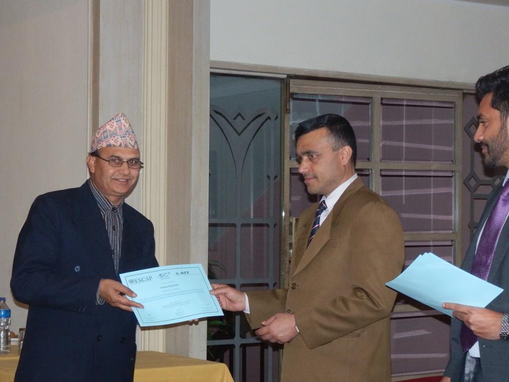
8 Backup and Restore o Configuration backup o Data backup o Design backup o Templates backup Document Management o Set maximum documents size o Uploadable document types At the end of the training, an official closing ceremony was held at the training venue. Mr. Pradeep Koirala, Under Secretary of Ministry of Home Affairs, Nepal chaired the event. Mr. Jeewan Rai from Armed Police Force, Nepal and Mr. Mukesh Keshari from Ministry of Home Affairs, Nepal presented the outcomes of the training and demonstrated the systems they developed. Mr. Syed T. Ahmed, the representative of UNESCAP, Bangkok Office emphasized the scope of the project and future collaboration opportunities during his speech. Dr. Lal Samarakoon, the director of Geoinformatics Center, AIT also addressed the group and acknowledge the positive steps taken by the Nepal agencies specially the Ministry of Home Affairs as a result of this project. Addressing participants Mr. Pradeep Koirala, Under Secretary of Ministry of Home Affairs thanked UNESCAP, GIC-AIT and all the responsible stakeholders. Finally the Joint Secretary distributed the certificates to the participants for successfully completing the training. Recommendations 1. Provision for Infrastructure: Number of agencies learnt to establish a Geo Portal are capable of doing by their own. The actual implementation may not take place if agencies are not have their servers (own or rented), data to share and internet access. It is necessary to motivate the decision makers to invest on required infrastructure for establishing a Geo Portal for real implementation. 2. Dedicated Staff: This is as important as infrastructure. In the case of Nepal, MOHA has assigned dedicated computer staff to establish the system with few other supporting staff and this human resources allocation works quire well. The staffs who are assigned are very keen to make the system works, and they are very motivated. This has to be observed when dealing with other countries.
9 3. Develop national collaboration; various organizations can have their own Geo Portal system developed following the system integration developed under ESCAP support or some other means. The important message is that the Geo-Portal systems belong to other agencies can be linked and all permitted data layers can be accessed within a given Geo-Portal framework. This would be a key advantage to motivate people to make use of this system as it provides a shared but secure platform to access data among the agencies, without duplicating data.
10 Technical Assistance on Annex 1 LIST OF PARTICIPANTS Ministry of Home Affairs Mr. Gautam Bhandari, Computer System Operator, Ministry of Home Affairs (MOHA), National Emergency Operation Centre (NEOC), Singha Durbar, Kathmandu, Tel: , Mb: , Fax: , neoc@moha.gov.np Mr. Krishna Raj Dhakal, Senior Administrative Assistant (Nayab Subba), Ministry of Home Affairs (MOHA), Singha Durbar, Kathmandu, Tel: , , Mb: , Fax: , , krishnadhakal10@gmail.com Mr. Manjul Maskey, Computer Officer, Ministry of Home Affairs (MOHA), Singha Durbar, Kathmandu, Tel: , Mb: , Fax: , control@moha.gov.np Mr. Mukesh Kumar Keshari, Computer Engineer, Ministry of Home Affairs (MOHA), Singha Durbar, Kathmandu, Tel: , Mb: , Fax: , mukesh525@gmail.com Mr. Mohan Akela, Senior Officer, Ministry of Home Affairs (MOHA), Singha Durbar, Kathmandu Mr. Rajendra Rupakheti, Senior Officer, Ministry of Home Affairs (MOHA), Singha Durbar, Kathmandu Purushottam Poudel, Computer Operator, Ministry of Home Affairs (MOHA), Singha Durbar, Kathmandu Sajiv Pariyar, Computer Operator, Ministry of Home Affairs (MOHA), Singha Durbar, Kathmandu Nepal Police Mr. Gyanendra Kumar Rai, Deputy Superintended of Police, Nepal Police Headquarter, Singha Durbar, Kathmandu, Mb: , rai_gk@nepalpolice.gov.np, rai_gk@hotmail.com Armed Police Force Mr. Jeewan Rai, GIS Expert, Armed Police Force, oracle03511@gmail.com National Planning Commission Mr. Chandra Bhakta Dhaubanjar, GIS Expert, National Planning Commission (NPC), cbdhaubanjar@gmail.com
11 Annex 2 SCHEDULE TIME Tuesday Wednesday Thursday Friday Opening Remarks UNESCAP 0900 h 1015 h Discussion Introduction to Geo-Portal Discussion Availability of country Data Introduction to QGIS Using free data (USGS, OSM, DEM, High Resolution Imagery) Thip New Experienced All Hands-on Data Upload: Upload own data sets to own Geo- Portal Participants Hands-on Functions and Techniques (Continued) Thip 1015 h 1045 h TEA BREAK 1045 h 1200 h Hands-on Introduction to Geo-Portal Upload sample data,thematic Maps, Meta Data Hands-on Functions and Techniques Create, Visualize, Simple Analysis, and Publish Thip Discussion Security: Data sharing Authorization Permission Modules Hands-On Estimation on elements affected by earthquake Administrative areas, population, and infrastructures Thip 1200 h 1300 h LUNCH BREAK Discussion/ Hands-on Setting up Environment Install Ubuntu in Participant s Discussion Map Printing, Map Publishing, Hands-On (Continued) 1300 h 1430 h Laptops Google Earth modules in Geo- Portal 1430 h 1500 h TEA BREAK Discussion/ Hands-on Hands-on Hands-On Configure Geo-Portal including local Customizing (Continued) 1500 h 1630 h information Geo-Portal Install, Configure Geo-Portal in Change logo and Participant s Laptops look & feel Thip Thip Discussion Dealing with external WMS Sources Temporary add data from external WMS sources Hands-on Dealing with external WMS Sources Permanently add external WMS sources to Geo- Portal Hands-on Access GeoNode data via QGIS Hands-on Add new Base Maps Add google satellite map as a default map in Geo-explorer view Discussion Backup Geo-Portal Backing up settings, data, templates Hands-on Backup Geo-Portal Backup/Restore a Geo-Portal Discussion/ Hands-on Changing document settings Set Maximum documents size, document types Discussion & Closing -Closing remarks -Evaluation UNESCAP


12 Annex 3 PHOTOS Mr. Shankar Koirala, Joint Secretary, MOHA chaired the opening ceremony During the Training


13 Mr. Pradeep Koirala, Under Secretary, MOHA chaired the closing ceremony Mr. Syed Ahmed addressing the participants


14 Armed Police Force Geo-Portal MOHA Geo-Portal
15 Certificate Distribution


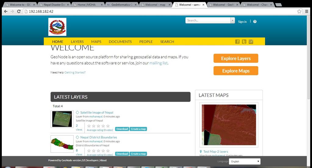
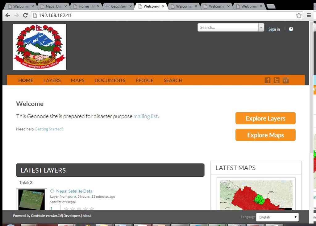
16 Annex 4 Screen-prints of the Geo-Portals developed during the training
17


18 Annex 5 Screen shot of GIS analysis on Data Resources and GIS analysis using QGIS Data Source: Landsat, Demonstration of Satellite data Overaly Data Source: Digital Globe (QB image), Geo-referenced Processing of satellite Data for Georeferncing


19 Visualization affected elements due to an Earthquake Working with Shake map (PGA value)
 Area è Expression:")

20 Facilities and Public Services affected by earthquake (September, 2011) Area è Expression: $area Pop_Den è Expression: "Pop2001" / "Area" Calculation proceeded to estimate population affected by earthquake
Regional EGM on Community of Practice of Georeferenced Information System. for Disaster Risk Management (Geo-DRM) April 2014, Bangkok, Thailand
 April 2014, Bangkok, Thailand") Regional EGM on Community of Practice of Georeferenced Information System for Disaster Risk Management (Geo-DRM) 23-25 April 2014, Bangkok, Thailand Presented By Mukesh Kumar Keshari Ministry of Home Affairs
Regional EGM on Community of Practice of Georeferenced Information System for Disaster Risk Management (Geo-DRM) 23-25 April 2014, Bangkok, Thailand Presented By Mukesh Kumar Keshari Ministry of Home Affairs
Sub-regional Training on development of Geo-referenced Disaster Risk Management Information Systems for SAARC countries
 Sub-regional Training on development of Geo-referenced Disaster Risk Management Information Systems for SAARC countries Jointly organized by Economic and Social Commission for Asia and the Pacific and
Overview of Technical Advisory Missions
 Expert Group Meeting (EGM) on Georeferenced Information Systems for Disaster Risk Management (Geo-DRM) and sustaining the Community of Practice (COP) 23-25 April 2014 Bangkok Overview of Technical Advisory
DP Project Development Pvt. Ltd.
 Dear Sir/Madam, Greetings!!! Thanks for contacting DP Project Development for your training requirement. DP Project Development is leading professional training provider in GIS technologies and GIS application
Capacity Building on Geoportals. Geoinformatics Centre, AIT, Thailand
 Capacity Building on Geoportals in PIC Geoinformatics Centre, AIT, Thailand Content 1. About Geoinformatics Centre, AIT, Thailand 2. Introduction to Project and Our Contribution 3. Web Maps and Geonode
Spatial Data Analysis with ArcGIS Desktop: From Basic to Advance
 Spatial Data Analysis with ArcGIS Desktop: From Basic to Advance 1. Course overview Modern environmental, energy as well as resource modeling and planning require huge amount of geographically located
Geospatial Technologies for Resources Planning & Management
 Geospatial Technologies for Resources Planning & Management Lal Samarakoon, PhD Director, Geoinformatics Center Asian Institute of Technology, Thailand Content Geoinformatics for SDG Information Integration
Data Aggregation with InfraWorks and ArcGIS for Visualization, Analysis, and Planning
 Data Aggregation with InfraWorks and ArcGIS for Visualization, Analysis, and Planning Stephen Brockwell President, Brockwell IT Consulting, Inc. Join the conversation #AU2017 KEYWORD Class Summary Silos
GIS Resources for Local Governments
 ISSUE PAPER SERIES GIS Resources for Local Governments February 2018 NEW YORK STATE TUG HILL COMMISSION DULLES STATE OFFICE BUILDING 317 WASHINGTON STREET WATERTOWN, NY 13601 (315) 785-2380 WWW.TUGHILL.ORG
Journey of supporting CSNs to establish Geo-DRM
 Regional Workshop on Geo-referenced Information Systems for Disaster Risk Management (Geo-DRM) 26-27 June 2014 Bangkok, Thailand Journey of supporting CSNs to establish Geo-DRM Keran Wang Chief, Space
Geospatial Information and Services for Disasters (GIS4D)
") Geospatial Information and Services for Disasters (GIS4D) 31 July 2017 Tae Hyung KIM ICT and Disaster Risk Reduction Division (IDD) UNESCAP 1 About ESCAP Who is ESCAP? United Nations Economic and Social
Geospatial Information and Services for Disasters (GIS4D) 31 July 2017 Tae Hyung KIM ICT and Disaster Risk Reduction Division (IDD) UNESCAP 1 About ESCAP Who is ESCAP? United Nations Economic and Social
Capacity Building Programme
 Capacity Building Programme 14-17 August 2012 Space Technology for improving Hazard Mapping in Sri Lanka An event organised as a follow up of the UN-SPIDER Technical Advisory Mission to Sri Lanka - 17-21
These modules are covered with a brief information and practical in ArcGIS Software and open source software also like QGIS, ILWIS.
 Online GIS Training and training modules covered are: 1. ArcGIS, Analysis, Fundamentals and Implementation 2. ArcGIS Web Data Sharing 3. ArcGIS for Desktop 4. ArcGIS for Server These modules are covered
ESCAP Promotes Geo-referenced Information System for Disaster Risk Management in Asia and the Pacific
 Third High Level Forum on UNGGIM 22-24 October 2014 Beijing, China ESCAP Promotes Geo-referenced Information System for Disaster Risk Management in Asia and the Pacific Keran Wang Space Applications Section,
Among various open-source GIS programs, QGIS can be the best suitable option which can be used across partners for reasons outlined below.
 Comparison of Geographic Information Systems (GIS) software As of January 2018, WHO has reached an agreement with ESRI (an international supplier of GIS software) for an unlimited use of ArcGIS Desktop
CHAPTER 22 GEOGRAPHIC INFORMATION SYSTEMS
 CHAPTER 22 GEOGRAPHIC INFORMATION SYSTEMS PURPOSE: This chapter establishes the administration and use of to improve the quality and accessibility of Department s spatial information and support graphical
ArcGIS. for Server. Understanding our World
 ArcGIS for Server Understanding our World ArcGIS for Server Create, Distribute, and Manage GIS Services You can use ArcGIS for Server to create services from your mapping and geographic information system
Discovery and Access of Geospatial Resources using the Geoportal Extension. Marten Hogeweg Geoportal Extension Product Manager
 Discovery and Access of Geospatial Resources using the Geoportal Extension Marten Hogeweg Geoportal Extension Product Manager DISCOVERY AND ACCESS USING THE GEOPORTAL EXTENSION Geospatial Data Is Very
GEOGRAPHICAL INFORMATION SYSTEMS. GIS Foundation Capacity Building Course. Introduction
 GEOGRAPHICAL INFORMATION SYSTEMS. GIS Foundation Capacity Building Course. Introduction In recent times digital mapping has become part and parcel of our daily lives with experience from Google Maps on
Challenges and Potentials of Place Based Information Management in Nepal"
 Nineteenth United Nations Regional Cartographic Conference for Asia and the Pacific, Bangkok, Thailand, 29 October 1 November 2012 Challenges and Potentials of Place Based Information Management in Nepal"
GIS ADMINISTRATOR / WEB DEVELOPER EVANSVILLE-VANDERBURGH COUNTY AREA PLAN COMMISSION
 GIS ADMINISTRATOR / WEB DEVELOPER EVANSVILLE-VANDERBURGH COUNTY AREA PLAN COMMISSION SALARY RANGE INITIATION $43,277 SIX MONTHS $45,367 POSITION GRADE PAT VI The Evansville-Vanderburgh County Area Plan
ArcGIS Earth for Enterprises DARRON PUSTAM ARCGIS EARTH CHRIS ANDREWS 3D
 ArcGIS Earth for Enterprises DARRON PUSTAM ARCGIS EARTH CHRIS ANDREWS 3D ArcGIS Earth is ArcGIS Earth is a lightweight globe desktop application that helps you explore any part of the world and investigate
Desktop GIS for Geotechnical Engineering
 Desktop GIS for Geotechnical Engineering Satya Priya Deputy General Manager (Software) RMSI, A-7, Sector 16 NOIDA 201 301, UP, INDIA Tel: +91-120-2511102 Fax: +91-120-2510963 Email: Satya.Priya@rmsi.com
Brazil Paper for the. Second Preparatory Meeting of the Proposed United Nations Committee of Experts on Global Geographic Information Management
 Brazil Paper for the Second Preparatory Meeting of the Proposed United Nations Committee of Experts on Global Geographic Information Management on Data Integration Introduction The quick development of
SRJC Applied Technology 54A Introduction to GIS
 SRJC Applied Technology 54A Introduction to GIS Overview Lecture of Geographic Information Systems Fall 2004 Santa Rosa Junior College Presented By: Tim Pudoff, GIS Coordinator, County of Sonoma, Information
GeoSUR SRTM 30-m / TPS
 GeoSUR SRTM 30-m / TPS Wm Matthew Cushing (USGS) 16 May 2013 U.S. Department of the Interior U.S. Geological Survey SRTM Mission Shuttle Radar Topography Mission (SRTM) Space Shuttle Endeavour during the
Geo-portal as a Data Sharing Platform for Early Warning System in the Pacific
 EXPERT SEMINAR ON INTEGRATED STATISTICS FOR THE SDGS Geo-portal as a Data Sharing Platform for Early Warning System in the Pacific 11-13 DECEMBER 2017 BANGKOK, THAILAND Youjin Choe Natural disasters and
Crowdsourcing approach for large scale mapping of built-up land
 Crowdsourcing approach for large scale mapping of built-up land Kavinda Gunasekara Kavinda@ait.asia Geoinformatics Center Asian Institute of Technology, Thailand. Regional expert workshop on land accounting
Spatial Statistical Information Services in KOSTAT
 Distr. GENERAL WP.30 12 April 2010 ENGLISH ONLY UNITED NATIONS ECONOMIC COMMISSION FOR EUROPE (UNECE) CONFERENCE OF EUROPEAN STATISTICIANS EUROPEAN COMMISSION STATISTICAL OFFICE OF THE EUROPEAN UNION (EUROSTAT)
GEOMATICS AND DISASTER MANAGEMENT: Early Impact assessment in Haiti
 GEOMATICS AND DISASTER MANAGEMENT: Early Impact assessment in Haiti We will talk about... Post-disaster response: the main questions to be answered Post-disaster rapid mapping: the role of Geomatics The
Spatial Data Availability Energizes Florida s Citizens
 NASCIO 2016 Recognition Awards Nomination Spatial Data Availability Energizes Florida s Citizens State of Florida Agency for State Technology & Department of Environmental Protection Category: ICT Innovations
REPORT ON INVESTMENTS
 REPORT ON INVESTMENTS D.T2.3.3 Investments for technical equipment for the implementation of Web-GIS platform in Mantova 1 Local support group designing Mantova Web-GIS platform. Picture by Maria Giulia
Portal for ArcGIS: An Introduction. Catherine Hynes and Derek Law
 Portal for ArcGIS: An Introduction Catherine Hynes and Derek Law Agenda Web GIS pattern Product overview Installation and deployment Configuration options Security options and groups Portal for ArcGIS
PHASE 1_7 TH SESSION ARCGIS TRAINING AT KU GIS LABS: INTRODUCTION TO GIS: EXPLORING ARCCATALOG AND ARCGIS TOOLS
 PHASE 1_7 TH SESSION ARCGIS TRAINING AT KU GIS LABS: INTRODUCTION TO GIS: EXPLORING ARCCATALOG AND ARCGIS TOOLS 7 TH SESSION REPORT: 10 TH - 12 TH SEPTEMBER 2014 SCHOOL OF ENGINEERING AND TECHNOLOGY COMPUTER
ARCGIS TRAINING AT KU GIS LABS: INTRODUCTION TO GIS: EXPLORING ARCCATALOG AND ARCGIS TOOLS
 PHASE 1_3 rd SESSION ARCGIS TRAINING AT KU GIS LABS: INTRODUCTION TO GIS: EXPLORING ARCCATALOG AND ARCGIS TOOLS 3 rd SESSION REPORT: 25 TH -27 TH JUNE 2014 SCHOOL OF ENVIRONMENTAL STUDIES COMPUTER LAB
RESAP Progress Report
 RESAP Progress Report December 2016 to October 2017 Presentation to the Twenty-first session of the Intergovernmental Consultative Committee on the Regional Space Applications Programme for Sustainable
Applied Geoscience and Technology Division SOPAC. Joy Papao, Risk Information Systems Officer
 Joy Papao, Risk Information Systems Officer Secretariat of the Pacific Community SPC 22 Pacific Island States Head office in Noumea, New Caledonia 2 Regional offices (Pohnpei and Honiara) 600 staff 9 Technical
Towards National Geographic Information System in Nepal
 2 nd High Level Forum on Global Geospatial Information Management, Qatar National Convention Centre, Doha, Qatar, 4 6 February, 2013 Towards National Geographic Information System in Nepal Krishna Raj
SCHOOL OF ENGINEERING AND TECHNOLOGY COMPUTER LAB
 PHASE 1_6 TH SESSION ARCGIS TRAINING AT KU GIS LABS: INTRODUCTION TO GIS: EXPLORING ARCCATALOG AND ARCGIS TOOLS 6 TH SESSION REPORT: 3 RD -5 TH SEPTEMBER 2014 SCHOOL OF ENGINEERING AND TECHNOLOGY COMPUTER
Leveraging Web GIS: An Introduction to the ArcGIS portal
 Leveraging Web GIS: An Introduction to the ArcGIS portal Derek Law Product Management DLaw@esri.com Agenda Web GIS pattern Product overview Installation and deployment Configuration options Security options
Introduction to Portal for ArcGIS. Hao LEE November 12, 2015
 Introduction to Portal for ArcGIS Hao LEE November 12, 2015 Agenda Web GIS pattern Product overview Installation and deployment Security and groups Configuration options Portal for ArcGIS + ArcGIS for
for Effective Land Administration
 Role of Geospatial Technology in Land Information System(LIS) for Effective Land Administration Dr. Deb Jyoti Pal Sections Role of GIS in Land Records Proposed Work Flow Case Studies Role of GIS Creating
Key Points Sharing fosters participation and collaboration Metadata has a big role in sharing Sharing is not always easy
 Sharing Resources Geoff Mortson esri, Inc. SDI Solutions Team Key Points Sharing fosters participation and collaboration Metadata has a big role in sharing Sharing is not always easy Data Sharing is Good
Overview. Everywhere. Over everything.
 Cadenza Desktop Cadenza Web Cadenza Mobile Cadenza Overview. Everywhere. Over everything. The ultimate GIS and reporting suite. Provide, analyze and report data efficiently. For desktop, web and mobile.
One platform for desktop, web and mobile
 One platform for desktop, web and mobile Search and filter Get access to all data thematically filter data in context factually and spatially as well as display it dynamically. Export a selection or send
Spatial Data Infrastructure for Prosperous Nepal
 Spatial Data Infrastructure for Prosperous Nepal Rabin K. SHARMA and Babu Ram ACHARYA, Nepal Key words: Metadata, Clearinghouse, Sustainable development, Good governance, SUMMARY This paper examines the
European Location Framework data in the ArcGIS platform
 European Location Framework data in the ArcGIS platform Presentation to: Author: Date: INSPIRE Conference 2016 Clemens Portele 26 September 2016 Why ELF? Global (e.g. UN GGIM) Regional Europe (INSPIRE
The econ Planning Suite: CPD Maps and the Con Plan in IDIS for Consortia Grantees Session 1
 The econ Planning Suite: CPD Maps and the Con Plan in IDIS for Consortia Grantees Session 1 1 Training Objectives Use CPD Maps to analyze, assess, and compare levels of need in your community Use IDIS
Working with ArcGIS Online
 Esri International User Conference San Diego, CA Technical Workshops July 12, 2011 Working with ArcGIS Online Bern Szukalski, Deane Kensok Topics for this Session ArcGIS Online Overview ArcGIS Online Content
Economic and Social Council
 United Nations Economic and Social Council Distr.: General 2 July 2012 E/C.20/2012/10/Add.1 Original: English Committee of Experts on Global Geospatial Information Management Second session New York, 13-15
GIS at UCAR. The evolution of NCAR s GIS Initiative. Olga Wilhelmi ESIG-NCAR Unidata Workshop 24 June, 2003
 GIS at UCAR The evolution of NCAR s GIS Initiative Olga Wilhelmi ESIG-NCAR Unidata Workshop 24 June, 2003 Why GIS? z z z z More questions about various climatological, meteorological, hydrological and
Use of geo-referenced data for DRM in Central Asia, problems and prospective
 Use of geo-referenced data for DRM in Central Asia, problems and prospective Dr. Akylbek Chymyrov Director, Kyrgyz Center of Geoinformation Systems Member of the Public Supervisory Board MES KR KSUCTA,
GEOGRAPHIC INFORMATION SYSTEMS Session 8
 GEOGRAPHIC INFORMATION SYSTEMS Session 8 Introduction Geography underpins all activities associated with a census Census geography is essential to plan and manage fieldwork as well as to report results
Overview of Geospatial Open Source Software which is Robust, Feature Rich and Standards Compliant
 Overview of Geospatial Open Source Software which is Robust, Feature Rich and Standards Compliant Cameron SHORTER, Australia Key words: Open Source Geospatial Foundation, OSGeo, Open Standards, Open Geospatial
NR402 GIS Applications in Natural Resources
 NR402 GIS Applications in Natural Resources Lesson 1 Introduction to GIS Eva Strand, University of Idaho Map of the Pacific Northwest from http://www.or.blm.gov/gis/ Welcome to NR402 GIS Applications in
ARCGIS TRAINING AT KU GIS LABS: INTRODUCTION TO GIS: EXPLORING ARCCATALOG AND ARCGIS TOOLS
 PHASE 1_4 th SESSION ARCGIS TRAINING AT KU GIS LABS: INTRODUCTION TO GIS: EXPLORING ARCCATALOG AND ARCGIS TOOLS 4 th SESSION REPORT: 30 TH JUNE - 2 ND JULY SCHOOL OF ENVIRONMENTAL STUDIES COMPUTER LAB
Increasing GI awareness in local authorities in Poland experiences from the INSPIRE Academy training programme
 Increasing GI awareness in local authorities in Poland experiences from the INSPIRE Academy training programme http://www.akademiainspire.pl Maria Andrzejewska, Monika Rusztecka UNEP/GRID-Warsaw Centre,
Finding Common Ground Through GIS
 Finding Common Ground Through GIS Matthew Stone, MPH Special Unit for Technical Assistance Chronic Disease and Injury Control California Department of Public Health ESRI Health GIS Conference Scottsdale,
Turkey s National SDI Implementation
 Onur PAŞAOĞULLARI Head of Department Turkey s National SDI Implementation Presentation Plan NSDI Background General Directorate of Geographic Information Systems NSDI Project INSPIRE Directive Urban Information
Introduction to Portal for ArcGIS
 Introduction to Portal for ArcGIS Derek Law Product Management March 10 th, 2015 Esri Developer Summit 2015 Agenda Web GIS pattern Product overview Installation and deployment Security and groups Configuration
Economic and Social Council
 United Nation E/C.20/2012/4/Add.1 Economic and Social Council Distr.: General 2 July 2012 Original: English Committee of Experts on Global Geospatial Information Management Second session New York, 13-15
Implementing the Sustainable Development Goals: The Role of Geospatial Technology and Innovation
 Fifth High Level Forum on UN Global Geospatial Information Management Implementing the Sustainable Development Goals: The Role of Geospatial Technology and Innovation 28-30 November 2017 Sheraton Maria
CHAPTER 3 RESEARCH METHODOLOGY
 CHAPTER 3 RESEARCH METHODOLOGY 3.1 INTRODUCTION The research methodology plays an important role in implementing the research and validating the results. Therefore, this research methodology is derived
Leveraging Your Geo-spatial Data Investments with Quantum GIS: an Open Source Geographic Information System
 Leveraging Your Geo-spatial Data Investments with Quantum GIS: an Open Source Geographic Information System Donald L. Schrupp Colorado Division of Wildlife (Retired) Danny Lewis Texas Parks and Wildlife
The Emerging Role of Enterprise GIS in State Forest Agencies
 The Emerging Role of Enterprise GIS in State Forest Agencies Geographic Information System (GIS) A geographic information system (GIS) is a computer software system designed to capture, store, manipulate,
Building Institutional Capacity for Multi-Hazard Early Warning in Asia and the Pacific Subtitle
 Building Institutional Capacity for Multi-Hazard Early Warning in Asia and the Pacific Subtitle Title Keran Wang Chief, Space Applications Section ICT and Disaster Risk Reduction Division 22 May 2018 Pillar
Report of the Regional Committee of UN-GGIM for Asia and the Pacific (UN-GGIM-AP)
") Report of the Regional Committee of UN-GGIM for Asia and the Pacific (UN-GGIM-AP) At the Eighth Session of UN-GGIM UN Headquarters, New York, 1 3 August 2018 About UN-GGIM-AP One of the five regional committees
Report of the Regional Committee of UN-GGIM for Asia and the Pacific (UN-GGIM-AP) At the Eighth Session of UN-GGIM UN Headquarters, New York, 1 3 August 2018 About UN-GGIM-AP One of the five regional committees
GIS = Geographic Information Systems;
 What is GIS GIS = Geographic Information Systems; What Information are we talking about? Information about anything that has a place (e.g. locations of features, address of people) on Earth s surface,
HISTORY OF GIS AND ESRI
 HISTORY OF GIS AND ESRI First Developed by Dr. Roger Tomlinson in Canada 1960 (CGIS Canadian geographic system) The system was designed to inventory land use and assist in the management of natural resources
Geo-information and Disaster Risk Reduction in the Hindu Kush-Himalayan region
 Geo-information and Disaster Risk Reduction in the Hindu Kush-Himalayan region Basanta Shrestha, Division Head MENRIS, International Centre for Integrated Mountain Development Kathmandu, Nepal The International
Salisbury University: Eric Flint, John O Brien, & Alex Nohe
 Salisbury University: Eric Flint, John O Brien, & Alex Nohe Open Source (Public) Geographic Information System GNU General Public License Guarantees public s ability to download, modify and share software
Introduction to Coastal GIS
 Introduction to Coastal GIS Event was held on Tues, 1/8/13 - Thurs, 1/10/13 Time: 9:00 am to 5:00 pm Location: Roger Williams University, Bristol, RI Audience: The intended audiences for this course are
Use of administrative registers for strengthening the geostatistical framework of the Census of Agriculture in Mexico
 Use of administrative registers for strengthening the geostatistical framework of the Census of Agriculture in Mexico Susana Pérez INEGI, Dirección de Censos y Encuestas Agropecuarias. Avenida José María
Report of the Working Group 2 Data Sharing and Integration for Disaster Management *
 UNITED NATIONS E/CONF.104/6 ECONOMIC AND SOCIAL COUNCIL Twentieth United Nations Regional Cartographic Conference for Asia and the Pacific Jeju, 6-9 October 2015 Item 5 of the provisional agenda Report
From PCGIAP to UN GGIM AP: A Regional Perspective on GGIM
 Regional Committee of United Nations Global Geospatial Information Management for Asia and the Pacific (UN-GGIM-AP) Established by a United Nations Resolution From PCGIAP to UN GGIM AP: A Regional Perspective
Welcome to NR502 GIS Applications in Natural Resources. You can take this course for 1 or 2 credits. There is also an option for 3 credits.
 Welcome to NR502 GIS Applications in Natural Resources. You can take this course for 1 or 2 credits. There is also an option for 3 credits. The 1st credit consists of a series of readings, demonstration,
NATO Headquarters The Situation Center GIS experience.
 NATO Headquarters The Situation Center GIS experience. Abstract Recently, the dynamic capability of responding to a major world crisis with comprehensive in-depth information has become a crucial aspect
Presented to Sub-regional workshop on integration of administrative data, big data and geospatial information for the compilation of SDG indicators
 Presented to Sub-regional workshop on integration of administrative data, big data and geospatial information for the compilation of SDG indicators 23-25 April,2018 Addis Ababa, Ethiopia By: Deogratius
Introduction to Geographic Information Systems (GIS): Environmental Science Focus
: Environmental Science Focus") Introduction to Geographic Information Systems (GIS): Environmental Science Focus September 9, 2013 We will begin at 9:10 AM. Login info: Username:!cnrguest Password: gocal_bears Instructor: Domain: CAMPUS
Introduction to Geographic Information Systems (GIS): Environmental Science Focus September 9, 2013 We will begin at 9:10 AM. Login info: Username:!cnrguest Password: gocal_bears Instructor: Domain: CAMPUS
Experiences and Directions in National Portals"
 FIG Seminar on e-land Administration Innsbruck/Austria 2-4 June 2004 "ESRI's Experiences and Directions in National Portals" Kevin Daugherty Cadastral/Land Records Manager ESRI Topic Points Technology
How does ArcGIS Server integrate into an Enterprise Environment? Willy Lynch Mining Industry Specialist ESRI, Denver, Colorado USA
 How does ArcGIS Server integrate into an Enterprise Environment? Willy Lynch Mining Industry Specialist ESRI, Denver, Colorado USA wlynch@esri.com ArcGIS Server Technology Transfer 1 Agenda Who is ESRI?
Getting Started with Community Maps
 Esri International User Conference San Diego, California Technical Workshops July 24, 2012 Getting Started with Community Maps Shane Matthews and Tamara Yoder Topics for this Session ArcGIS is a complete
Features and Benefits
 Autodesk LandXplorer Features and Benefits Use the Autodesk LandXplorer software family to help improve decision making, lower costs, view and share changes, and avoid the expense of creating physical
Geospatial Products V8i (SELECTseries 1)
") Geospatial Products V8i (SELECTseries 1) Keith Raymond Product Manager Geospatial Desktop Products Presentation Overview What are the various products? Why would you need them? Demonstrations 2 WWW.BENTLEY.COM
Geospatial Products V8i (SELECTseries 1) Keith Raymond Product Manager Geospatial Desktop Products Presentation Overview What are the various products? Why would you need them? Demonstrations 2 WWW.BENTLEY.COM
GIS Integration to Maximo
 GIS Integration to Maximo Tuesday 15 th January 2008 Mahmoud Jaafar Systems Director GISTEC Agenda Introduction Why AMS & GIS Integration? ESRI GIS Enabling Technology. Integrating GIS & Maximo. What do
Web GIS Patterns and Practices
 FedGIS Conference February 24 25, 2016 Washington, DC Web GIS Patterns and Practices Philip Heede Jay Theodore Witt Mathot Web GIS Transformation of the ArcGIS Platform Desktop Apps Web Maps Web Scenes
Esri UC2013. Technical Workshop.
 Esri International User Conference San Diego, California Technical Workshops July 9, 2013 CAD: Introduction to using CAD Data in ArcGIS Jeff Reinhart & Phil Sanchez Agenda Overview of ArcGIS CAD Support
Projection and Reprojection
 Using Quantum GIS Tutorial ID: IGET_GIS_002 This tutorial has been developed by BVIEER as part of the IGET web portal intended to provide easy access to geospatial education. This tutorial is released
ArcGIS Pro: Essential Workflows STUDENT EDITION
 ArcGIS Pro: Essential Workflows STUDENT EDITION Copyright 2018 Esri All rights reserved. Course version 6.0. Version release date August 2018. Printed in the United States of America. The information contained
Spatially Enabled Society
 International Seminar on Land Administration Trends and Issues in Asia and the Pacific Region Spatially Enabled Society Abbas Rajabifard Vice Chair PCGIAP-WG3 Vice-President (President Elect), GSDI Association
Combining Geospatial and Statistical Data for Analysis & Dissemination
 Combining Geospatial and Statistical Data for Analysis & Dissemination (with Special Reference to Qatar Census 2010) Presentation by Mansoor Al Malki, Director of IT Department Qatar Statistics Authority
Introduction to Google Mapping Tools
 Introduction to Google Mapping Tools Google s Mapping Tools Explore geographic data. Organize your own geographic data. Visualize complex data. Share your data with the world. Tell your story and educate
National workshop on sustainable urban and industry development in Mongolia objective, expected outcomes and schedule
 GEO-REF Information Eco-Efficient Urban Infrastructure, and Platform Green for & Disaster Livable Management Cities National workshop on sustainable urban and industry development in Mongolia objective,
An introduction to ArcGIS Maps for Office. Scott Ball & Mike Flanagan
 An introduction to ArcGIS Maps for Office Scott Ball & Mike Flanagan Main takeaways for today Adding the where to your analysis You can learn a lot when you unlock the power of geography in your analytics
KUNMING FORUM ON UNITED NATIONS GLOBAL GEOSPATIAL INFORMATION MANAGEMENT CITIES OF THE FUTURE: SMART, RESILIENT
 KUNMING FORUM ON UNITED NATIONS GLOBAL GEOSPATIAL INFORMATION MANAGEMENT CITIES OF THE FUTURE: SMART, RESILIENT and SUSTAINABLE Yunnan Zhenzhuang Guest House, Kunming, China 10 12 May 2017 BACKGROUND CONCEPT
COURSE OUTLINE GEOL204 MINING COMPUTING 3 CREDITS
 COURSE OUTLINE GEOL204 MINING COMPUTING 3 CREDITS PREPARED BY: Joel Cubley, Instructor DATE: June 1, 2018 APPROVED BY: Margaret Dumkee, Dean DATE: June 1, 2018 APPROVED BY ACADEMIC COUNCIL: May 2014 GEOL204
You are Building Your Organization s Geographic Knowledge
 You are Building Your Organization s Geographic Knowledge And Increasingly Making it Available Sharing Data Publishing Maps and Geo-Apps Developing Collaborative Approaches Citizens Knowledge Workers Analysts
file://q:\report1\greenatlasfinalreportindex.html
 Page 1 of 8 Quick Links WATER MANAGEMENT INTERNSHIP USDA HIS GRANT FUNDED FINAL PROJECT REPORT SUBMITTED BY MELISSA QUINTANA 11/07/07-03/24/08 Summary Provided is an assessment of my accomplishments for
FREE GIS PLUS DATABASE SYSTEM FOR DISSEMINATION ACTIVITY OF EARTHQUAKE DISASTER MITIGATION
 FREE GIS PLUS DATABASE SYSTEM FOR DISSEMINATION ACTIVITY OF EARTHQUAKE DISASTER MITIGATION T. Yokoi 1, J. Subedi 2, R. Rajbhandari 3, M. B. Prajapati 4, T. Mori 5, A. Takubo 6, M. Niwa 7 ABSTRACT : 1 Senior
No. of Days. ArcGIS 3: Performing Analysis ,431. Building 3D cities Using Esri City Engine ,859
 What s New? Creating Story Maps with ArcGIS Field Data Collection and Management Using ArcGIS Get Started with Insights for ArcGIS Introduction to GIS Using ArcGIS & ArcGIS Pro: Essential Workflow Migrating