ENGRG Introduction to GIS
|
|
|
- Hollie Benson
- 6 years ago
- Views:
Transcription


1 ENGRG Introduction to GIS Michael Piasecki May 1, 2014 Lecture 13: GIS Modeling and Programming Spatial Modeling and Programming The slides about GIS modeling in this lecture are prepared by Dr. Michael W. Binford, U of Florida 5/1/2014 ENGRG Intro to GIS 2 1
2 Spatial Modeling Cartographic Model (static) Spatial temporal Model (dynamic) Cell based model (cellular automata, CA) Agent based model 5/1/2014 ENGRG Intro to GIS 3 Spatial Modeling and Cartographic Modeling Designing the best cartographic model to solve a problem the selection of the appropriate spatial tools and the specification of their sequence is perhaps the most important and often the most difficult process in cartographic modeling. 5/1/2014 ENGRG Intro to GIS 4 2
3 Definition of Model Simplified, idealized representation of a part of the real world Learning Tool Experimental Tool Constantly tested by comparison with the real world Useful insofar as they explain or simulate the real world 5/1/2014 ENGRG Intro to GIS 5 Models come in many, many flavors. Analysis Models Step by step description of how problems are solved. Representation models images, dioramas, wind tunnel models, flow channels, sand tables, maps, globes. Conceptual models no numerical values or formulas Theoretical models with numerical values or formula Empirical models based on observations, but the mechanism may be unknown. Statistical, e.g. Regression Models Rule based Models Models based on many measurements (e.g. USLE, RUSLE) Physical mathematical models based on physical laws, first principles Stochastic models bases on the concept of randomness and probability: Random numbers simulate variation. 5/1/2014 ENGRG Intro to GIS 6 3


4 Representation Models 5/1/2014 ENGRG Intro to GIS 7 Representation Models in GIS Digital Elevation Model 5/1/2014 ENGRG Intro to GIS 8 4
5 GIS Modeling Representation Modeling Exploratory Data Analysis Environmental Modeling Environmental Risk Assessment Atmospheric Modeling Soil Erosion Modeling Hydrological Topographic Modeling Watershed Analysis Dynamic Modeling Land water interactions Habitat Modeling Human Environment Modeling Land Suitability Modeling Land use/land cover change Economic models (Walker) Agent based models Archaeological Modeling Decision Support Systems Land allocation Agroforestry (Ellis) Business/Economic Modeling Thrall Emergency Management 5/1/2014 ENGRG Intro to GIS 9 Different Models for Different Questions Define Problem Recognize Context Define Time Data Landscape Description Landscape Function Representation Models Process Models Information Is the Landscape Working Well? Evaluation Models Cultural Knowledge Steinitz et al Landscape Change (Scenarios?) How will the change(s) affect Landscape Function? How should the landscape be changed? Change Models Impact Models Decision Models 5/1/2014 ENGRG Intro to GIS 10 5
6 Analytical Models: Project Design With Cartographic Modeling Cartographic Modeling (= Spatial Modeling) Models (representations) using Maps (Cartography) Analytical model based on simple, sequential operations. Start: What is the Question? What are the Objectives? Soils Land Use Property Reclass Dissolve Reclass Fertile and Infertile Soils Ag vs. Forest Private and Public Ownership Overlay: Intersection Fertile Forest Soils Clip Start here. Final Product Objective: Map of Lands to Buy (Fertile Forest Soils in Private Ownership) 5/1/2014 ENGRG Intro to GIS 11 Principles of Cartographic Modeling 1. Cartographic Modeling emphasizes process, not data specifics. (Should accommodate new/changed data.) 2. Cartographic Modeling decomposes analytical tasks into elementary components that can be combined into complicated algorithms. 3. Cartographic modeling is useful for making the work flow more efficient. 4. Every object class (data, operation, map, etc.) has a specific symbol. 5. Useful flowcharts (Cartographic Models) should contain enough information for both you and someone else to reproduce the analysis. 5/1/2014 ENGRG Intro to GIS 12 6
7 Cartographic Modeling: Methods of Flowcharting After the question and objectives are adequately defined, Determine the output product FIRST. What are the final maps, tables, graphs that you need to determine and support the conclusions of your study? Break up the task into smaller sub tasks by working backwards from the final result. Define how you will combine variables and operations to achieve the final maps, tables, graphs, etc. Isolate each element (data, map, intermediate result, operation) that will be used in the model. Determine the input data. What do you have/need to solve a specific problem? 5/1/2014 ENGRG Intro to GIS 13 A note about cartographic modeling Qualitative statements ( too steep, big enough, far away ) must be made quantitative. (GIS generally not good at fuzzy.) Consultation, meetings, discussions, etc., with client group may be necessary. 5/1/2014 ENGRG Intro to GIS 14 7
8 Terrible Cartographic Model Analyze Data Present Table of Results Get Data Say What??? 5/1/2014 ENGRG Intro to GIS 15 Examples of Spatial Models for Problem Solving Environmental Impact of a new Road 5/1/2014 ENGRG Intro to GIS 16 8
9 Problem 1 Problem: A new road is going to be built between cities A and B, through a forest with both high biodiversity and high development potential. Question: How much undisturbed forest is going to be affected? Principle: New roads affect a zone 2 km wide on each side of the road Sound Territorial Birds Water and Sediment Runoff 5/1/2014 ENGRG Intro to GIS 17 Problem 1 What do we want at the end? Affected land Area m 2 Natural Forest Disturbed Area Output Data Table with the area of affected lands To here? How do we get from here Input data Land Use/Cover Map Proposed New road 5/1/2014 ENGRG Intro to GIS 18 9
10 Problem 1 Can you come up with a flowchart for answering this specific problem? Possible Solution with Operations Available: Buffer Reclass Overlay (Intersection) 5/1/2014 ENGRG Intro to GIS 19 Problem 1 This problem can be solved with the procedure described in this flowchart Road Problem Flowchart Design Flow Table with areas affected Attribute table analysis 2-km Buffer in Vegetation Overlay (Intersection) Work Flow 2-km Buffers Natural/Non Natural Buffer Roads Data Land Cover Reclass 5/1/2014 ENGRG Intro to GIS 20 10
 has developed an empirical equation for estimating soil erosion (Universal Soil Loss Equation).")
 5/1/2014 ENGRG 59910 Intro to GIS 21 Problem 2 Output Data: Map showing the areas with the largest soil erosion losses Input Data Rainfall, Soils, Topographic")
11 Problem 2: Universal Soil Loss Equation, USLE In a given region, what are the areas with the largest soil losses? What are the magnitudes of the losses? The USDA (Dept of Agriculture) has developed an empirical equation for estimating soil erosion (Universal Soil Loss Equation). A= R*K*L*S*C*P R=Erosivity or Rainfall K=Soil characteristics L=Length of the slope (topographic) S=Slope (topographic) C=Type of cultivation P=Protection parameter (i.e terraces) 5/1/2014 ENGRG Intro to GIS 21 Problem 2 Output Data: Map showing the areas with the largest soil erosion losses Input Data Rainfall, Soils, Topographic Map, Land Use (Agriculture) 5/1/2014 ENGRG Intro to GIS 22 11
12 Problem 2 Operations available Arithmetic (x, +,, /) Reclass or Recode Slope and Length of Slope (Topographic) Greater Than, less than Can you create a flowchart for solving this problem? 5/1/2014 ENGRG Intro to GIS 23 Problem 2 Arithmetic (multiplication) Result Select Soil Loss >= X RKLSCP R K L S C P Reclass Rainfall Reclass Soils Length Topo Slope Reclass Land Cover Reclass 5/1/2014 ENGRG Intro to GIS 24 12


13 Example: Suitability Analysis For a park: Near lakes, near roads, not wetlands Landmark text: Ian McHarg, 1969 Design with Nature: transparent maps of value, overlaid; darker is better. 5/1/2014 ENGRG Intro to GIS 25 Example: Home Site Selection General Criteria Slopes not too steep Refined (Quantified) Criteria Slopes < 30 degrees Southern aspect preferred Soils suitable for septic system 90 < aspect <270 degrees Specified list of septic suitable soils Away from major roads, but not isolated 300m < distance to road < 2000m 5/1/2014 ENGRG Intro to GIS 26 13
14 Available data Raster Meet criteria? Assign codes for yes or no. Add, to ID areas of good slope & aspect by sum Suitable or unsuitable Simplify Not helpful to say overlay! Fig /1/2014 ENGRG Intro to GIS 27 Suitable or unsuitable Simplify Intersect, to map areas of suitable terrain AND soil 5/1/2014 ENGRG Intro to GIS 28 14
15 Exclude roads not major Two new polygon buffers Subtract, * to create new buffer poly of correct width Limit buffers to area of interest Intersect, to map areas meeting all criteria, or Simplify 5/1/2014 ENGRG Intro to GIS 29 Project Management: Flowcharting The major objective of a flowchart is to communicate the operations and their order to yourself as well as to someone else. Every object class (data, operation, map, etc.) has a specific symbol (e.g., in MS Office). Data - map Process - operation Statistical Table Decision x > y? Yes No Multiple Data Layers? 5/1/2014 ENGRG Intro to GIS 30 15
16 Points about Cartographic Modeling Cartographic Modeling comprises simple objects and operations; however, combining objects and operations in specific sequences becomes complicated. Begin at the end: What do we want? (Did I say this already?) Cartographic model, or flowchart, must be sufficiently comprehensive to inform the analyst and the audience. Another analyst should be able to reproduce your project by reading your flowchart. Reproducible = defensible. These are essential to good science. Criteria: opportunity for expert and public input to modeling! 5/1/2014 ENGRG Intro to GIS 31 Kinds of Model GIS Links 1. No GIS at all, but model is spatially explicit 2. GIS holds data, model is not spatially explicit but takes as input aggregated information calculated by GIS. 3. GIS holds data, model is not spatially explicit but runs within GIS. 4. GIS holds data, model is spatially explicit but runs outside GIS. 5. Model is integrated with GIS software. 5/1/2014 ENGRG Intro to GIS 32 16
17 Modeling Taxonomy of Models 5/1/2014 ENGRG Intro to GIS 33 GIS modeling Wrap Up Spatial Modeling is infinitely diverse limited only by your imagination. Not limited to functions already within GIS application software (ArcGIS, etc.) But, developing models outside of GIS software programs requires programming knowledge: Java, Python, Fortran, C++, VisualBasic, or any other. LEARN AT LEAST ONE PROGRAMMING LANGUAGE. What is your interest? 5/1/2014 ENGRG Intro to GIS 34 17
18 Second Part GIS Programming Why GIS Programming? To calculate values needed for analysis To perform repetitive tasks To created customized GIS interface for special purposes To automated complex GIS modeling 5/1/2014 ENGRG Intro to GIS 36 18
19 Example of Tasks Reproject 1000 shape files from Lon/Lat to UTM coordinates Build a simplified map interface for using by land manager with customized features Simulate flood progress when a certain event is happened. Include a map in an EXCEL spreadsheet 5/1/2014 ENGRG Intro to GIS 37 Why do you need to learn GIS Programming? For Research: Dynamic spatial modeling Repeated, intensive computing For Career: More easily to get a job More easily to get more $$ GIS Job Cleanhouse: 5/1/2014 ENGRG Intro to GIS 38 19
20 GIS Programming Languages: ESRI Products Suites ARC/INFO: Arc Macro Language (AML) : too old Essentially a list of normal ARC commands Some features for variables, looping etc. Used only in Arc/INFO ArcView (through V3.3) AVENUE language : too old Object oriented Programming Used only in ARCView ArcGIS: ArcObjects : that s right now, but it will be too old! COM complaint (Component Object Model), interface for software components, introduced by Microsoft in 1993, language neutral Whatever COM compatible language: Virtual Basic,Virtual Basic for Application, Python, C++, JAVA,.NET etc.) ArcGIS Engine and ArcGIS Server 5/1/2014 ENGRG Intro to GIS 39 ArcGIS Engine and ArcGIS Server Media Clip: introduction to ArcGIS Engine Introduction to ArcGIS Server: 5/1/2014 ENGRG Intro to GIS 40 20
21 Common themes in various programming languages (Chinese vs English) VS (C++ vs C#): the most important thing is the logical, rather than characters Common themes: Primitives (string name= GIS ) Control Flow (if, else, else if, then) Loops (count, condition or collection) Sub routine/function (private function dosth()) 5/1/2014 ENGRG Intro to GIS 41 Fundamentals of ArcObjects Object Oriented Programming (OOP) is a programming paradigm that represents the concept of "objects" that have data fields (attributes that describe the object) and associated procedures known as methods. Component Object Model (COM) language agnostic Objects vs. Classes Class is a construct that defines a collection of properties and methods Object is an instance of a class, it brings it to life Object Model Diagram 5/1/2014 ENGRG Intro to GIS 42 21
22 Benefits for using ArcObjects There are a large number of objects defined by ESRI which can control all aspects of ArcGIS applications Only requires you to know what the objects are and what methods and properties are available to you You can use any COM compatible language Python is really popular these days! The objects allow you to do EVERYTHING you can do in ARCGIS and more! 5/1/2014 ENGRG Intro to GIS 43 Challenge of using ArcObjects Some basic understanding of OOP language such as Visual Basic or Python is expected The large (huge?) number of objects available makes it difficult to locate the object or method you need 5/1/2014 ENGRG Intro to GIS 44 22


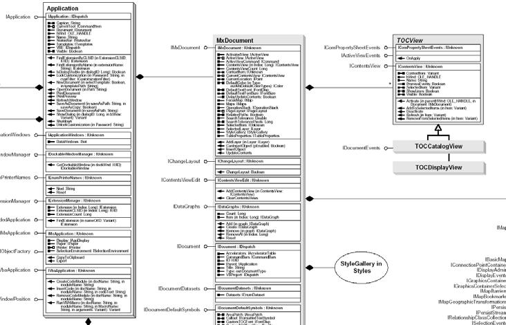
23 Object Model Diagram Object Model Diagram 5/1/2014 ENGRG Intro to GIS 45 Object Model Diagram 5/1/2014 ENGRG Intro to GIS 46 23


24 ArcObject in ArcMap 5/1/2014 ENGRG Intro to GIS 47 How to go about learning ArcObjects First go through a basic Visual Basic or Python book Think of a task that you want to tackle Find sample code that does something like what you are looking for Develop code snippets that work, then try to put them together 5/1/2014 ENGRG Intro to GIS 48 24
25 Places to find help Online Developers web site ArcObjects Developer Help Object Models Components/Core Components/Interfaces Sample Code Ask Google before asking anybody 5/1/2014 ENGRG Intro to GIS 49 Pain and Gain? 5/1/2014 ENGRG Intro to GIS 50 25
26 Thank you and Best wishes to you! Thank you for your participation in this GIS course! Wish you success with the skills learnt from this course! 5/1/2014 ENGRG Intro to GIS 51 26
SPATIAL MODELING GIS Analysis Winter 2016
 SPATIAL MODELING GIS Analysis Winter 2016 Spatial Models Spatial Modeling attempts to represent how the world works All models are wrong, but some are useful (G.E. Box, quoted in course textbook pg. 379)
SRJC Applied Technology 54A Introduction to GIS
 SRJC Applied Technology 54A Introduction to GIS Overview Lecture of Geographic Information Systems Fall 2004 Santa Rosa Junior College Presented By: Tim Pudoff, GIS Coordinator, County of Sonoma, Information
Course overview. Grading and Evaluation. Final project. Where and When? Welcome to REM402 Applied Spatial Analysis in Natural Resources.
 Welcome to REM402 Applied Spatial Analysis in Natural Resources Eva Strand, University of Idaho Map of the Pacific Northwest from http://www.or.blm.gov/gis/ Where and When? Lectures Monday & Wednesday
Spatio-temporal models
 Spatio-temporal models Involve a least a three dimensional representation of one or more key attribute variation in planar (X-Y) space and through time. (a 4 th dimension could also be use, like Z for
Exercise 6: Using Burn Severity Data to Model Erosion Risk
 Exercise 6: Using Burn Severity Data to Model Erosion Risk Document Updated: November 2009 Software Versions: ERDAS Imagine 9.3 and ArcGIS 9.3, Microsoft Office 2007 Introduction A common use of burn severity
Geog 469 GIS Workshop. Data Analysis
 Geog 469 GIS Workshop Data Analysis Outline 1. What kinds of need-to-know questions can be addressed using GIS data analysis? 2. What is a typology of GIS operations? 3. What kinds of operations are useful
GENERALIZATION IN THE NEW GENERATION OF GIS. Dan Lee ESRI, Inc. 380 New York Street Redlands, CA USA Fax:
 GENERALIZATION IN THE NEW GENERATION OF GIS Dan Lee ESRI, Inc. 380 New York Street Redlands, CA 92373 USA dlee@esri.com Fax: 909-793-5953 Abstract In the research and development of automated map generalization,
Geographic Information Systems. Introduction to Data and Data Sources
 Geographic Information Systems Introduction to Data and Data Sources Presented by John Showler, NJDA-SSCC NJ SCD GIS Training Session December 10, 209 The Objectives of this session are 3-fold: 1. Introduce
Watershed Application of WEPP and Geospatial Interfaces. Dennis C. Flanagan
 Watershed Application of WEPP and Geospatial Interfaces Dennis C. Flanagan Research Agricultural Engineer USDA-Agricultural Research Service Adjunct Professor Purdue Univ., Dept. of Agric. & Biol. Eng.
GIS FOR PLANNING. Course Overview. Schedule. Instructor. Prerequisites. Urban Planning 792 Thursday s 5:30-8:10pm SARUP 158
 GIS FOR PLANNING Urban Planning 792 Thursday s 5:30-8:10pm SARUP 158 Schedule Class/Lab - SARUP 158 Thursdays 5:30pm - 8:10pm Office Hours - By Appointment Project Ideas - Week 4 Final - 5/10/2018 Instructor
GIS model & modeling
 GIS model & modeling Model : a simplified representation of a phenomenon or a system. GIS modeling : the use of GIS in the process of building models with spatial data. Basic requirement in modeling :
NR402 GIS Applications in Natural Resources
 NR402 GIS Applications in Natural Resources Lesson 1 Introduction to GIS Eva Strand, University of Idaho Map of the Pacific Northwest from http://www.or.blm.gov/gis/ Welcome to NR402 GIS Applications in
Geospatial Fire Behavior Modeling App to Manage Wildfire Risk Online. Kenyatta BaRaKa Jackson US Forest Service - Consultant
 Geospatial Fire Behavior Modeling App to Manage Wildfire Risk Online Kenyatta BaRaKa Jackson US Forest Service - Consultant Fire Behavior Modeling and Forest Fuel Management Modeling Fire Behavior is an
StreamStats: Delivering Streamflow Information to the Public. By Kernell Ries
 StreamStats: Delivering Streamflow Information to the Public By Kernell Ries U.S. Department of the Interior U.S. Geological Survey MD-DE-DC District 410-238-4317 kries@usgs.gov StreamStats Web Application
Title: ArcMap: Calculating Soil Areas for Storm Water Pollution Prevention Plans Authors: Brandy Woodcock, Benjamin Byars
 Title: ArcMap: Calculating Soil Areas for Storm Water Pollution Prevention Plans Authors: Brandy Woodcock, Benjamin Byars Introduction Abstract: The use of ArcMap to calculate soil areas for storm water
Aileen Buckley, Ph.D. and Charlie Frye
 An Information Model for Maps: Towards Production from GIS Databases Aileen Buckley, Ph.D. and Charlie Frye Researchers, ESRI GIS vs. cart GIS Outline of the presentation Introduction Differences between
ArcGIS Tools for Professional Cartography
 ArcGIS Tools for Professional Cartography By Makram Murad-al-shaikh M.S. Cartography Senior instructor ESRI Educational Services ICC - A Coruña - Spain, 9-16 July, 2005 Overview Overview of the ArcGIS
![)UDQFR54XHQWLQ(DQG'tD]'HOJDGR&](/thumbs/95/125846872.jpg ")UDQFR54XHQWLQ(DQG'tD]'HOJDGR&") &21&(37,21$1',03/(0(17$7,212)$1+
&21&(37,21$1',03/(0(17$7,212)$1+ Review Using the Geographical Information System and Remote Sensing Techniques for Soil Erosion Assessment
 Polish J. of Environ. Stud. Vol. 19, No. 5 (2010), 881-886 Review Using the Geographical Information System and Remote Sensing Techniques for Soil Erosion Assessment Nuket Benzer* Landscape Architecture
Lecture 2. A Review: Geographic Information Systems & ArcGIS Basics
 Lecture 2 A Review: Geographic Information Systems & ArcGIS Basics GIS Overview Types of Maps Symbolization & Classification Map Elements GIS Data Models Coordinate Systems and Projections Scale Geodatabases
Introducing GIS analysis
 1 Introducing GIS analysis GIS analysis lets you see patterns and relationships in your geographic data. The results of your analysis will give you insight into a place, help you focus your actions, or
Delineation of high landslide risk areas as a result of land cover, slope, and geology in San Mateo County, California
 Delineation of high landslide risk areas as a result of land cover, slope, and geology in San Mateo County, California Introduction Problem Overview This project attempts to delineate the high-risk areas
ARCGIS PRO COURSE, APPLIED TO ENVIROMENTAL MANAGEMENT GIS. Course. Training. .com
 ARC PRO COURSE, APPLIED TO ENVIROMENTAL MANAGEMENT TYC Training Course.com TRAINING OVERVIEW This Arc Pro online course will provide a great deal of information about the link between earth s ecosystems
COMMON GIS TECHNIQUES FOR VECTOR AND RASTER DATA PROCESSING. Ophelia Wang, Department of Geography and the Environment, University of Texas
 COMMON GIS TECHNIQUES FOR VECTOR AND RASTER DATA PROCESSING Ophelia Wang, Department of Geography and the Environment, University of Texas PART I: BASIC VECTOR TOOLS CLIP A FEATURE BASED ON THE EXTENT
Pierce Cedar Creek Institute GIS Development Final Report. Grand Valley State University
 Pierce Cedar Creek Institute GIS Development Final Report Grand Valley State University Major Goals of Project The two primary goals of the project were to provide Matt VanPortfliet, GVSU student, the
GIS and Forest Engineering Applications FE 257 Lecture and laboratory, 3 credits
 GIS and Forest Engineering Applications FE 257 Lecture and laboratory, 3 credits Instructor: Michael Wing Associate Professor Forest Engineering, Resources, and Management Oregon State University Crop
STUDY GUIDE. Exploring Geography. Chapter 1, Section 1. Terms to Know DRAWING FROM EXPERIENCE ORGANIZING YOUR THOUGHTS
 For use with textbook pages 19 22. Exploring Geography Terms to Know location A specific place on the earth (page 20) absolute location The exact spot at which a place is found on the globe (page 20) hemisphere
LAND CHANGE MODELER SOFTWARE FOR ARCGIS
 LAND CHANGE MODELER SOFTWARE FOR ARCGIS The Land Change Modeler is revolutionary land cover change analysis and prediction software which also incorporates tools that allow you to analyze, measure and
Representation of Geographic Data
 GIS 5210 Week 2 The Nature of Spatial Variation Three principles of the nature of spatial variation: proximity effects are key to understanding spatial variation issues of geographic scale and level of
Development of a GIS Interface for WEPP Model Application to Great Lakes Forested Watersheds
 Development of a GIS Interface for WEPP Model Application to Great Lakes Forested Watersheds J.R. Frankenberger 1, S. Dun 2, D.C. Flanagan 1, J.Q. Wu 2, W.J. Elliot 3 1 USDA-ARS, West Lafayette, IN 2 Washington
Introduction-Overview. Why use a GIS? What can a GIS do? Spatial (coordinate) data model Relational (tabular) data model
 data model Relational (tabular) data model") Introduction-Overview Why use a GIS? What can a GIS do? How does a GIS work? GIS definitions Spatial (coordinate) data model Relational (tabular) data model intro_gis.ppt 1 Why use a GIS? An extension
Introduction-Overview Why use a GIS? What can a GIS do? How does a GIS work? GIS definitions Spatial (coordinate) data model Relational (tabular) data model intro_gis.ppt 1 Why use a GIS? An extension
Understanding Geographic Information System GIS
 Understanding Geographic Information System GIS What do we know about GIS? G eographic I nformation Maps Data S ystem Computerized What do we know about maps? Types of Maps (Familiar Examples) Street Maps
Display data in a map-like format so that geographic patterns and interrelationships are visible
 Vilmaliz Rodríguez Guzmán M.S. Student, Department of Geology University of Puerto Rico at Mayagüez Remote Sensing and Geographic Information Systems (GIS) Reference: James B. Campbell. Introduction to
Lecture 2. Introduction to ESRI s ArcGIS Desktop and ArcMap
 Lecture 2 Introduction to ESRI s ArcGIS Desktop and ArcMap Outline ESRI What is ArcGIS? ArcGIS Desktop ArcMap Overview Views Layers Attribute Tables Help! Scale Tips and Tricks ESRI Environmental Systems
Office of Geographic Information Systems
 Winter 2007 Department Spotlight SWCD GIS by Dave Holmen, Dakota County Soil and Water Conservation District The Dakota County Soil and Water Conservation District (SWCD) has collaborated with the Dakota
Outline. Chapter 1. A history of products. What is ArcGIS? What is GIS? Some GIS applications Introducing the ArcGIS products How does GIS work?
 Outline Chapter 1 Introducing ArcGIS What is GIS? Some GIS applications Introducing the ArcGIS products How does GIS work? Basic data formats The ArcCatalog interface 1-1 1-2 A history of products Arc/Info
Introduction to the 176A labs and ArcGIS
 Introduction to the 176A labs and ArcGIS Acknowledgement: Slides by David Maidment, U Texas-Austin and Francisco Olivera (TAMU) Purpose of the labs Hands-on experience with one software pakage Introduction
What are the five components of a GIS? A typically GIS consists of five elements: - Hardware, Software, Data, People and Procedures (Work Flows)
") LECTURE 1 - INTRODUCTION TO GIS Section I - GIS versus GPS What is a geographic information system (GIS)? GIS can be defined as a computerized application that combines an interactive map with a database
LECTURE 1 - INTRODUCTION TO GIS Section I - GIS versus GPS What is a geographic information system (GIS)? GIS can be defined as a computerized application that combines an interactive map with a database
Geographic Systems and Analysis
 Geographic Systems and Analysis New York University Robert F. Wagner Graduate School of Public Service Instructor Stephanie Rosoff Contact: stephanie.rosoff@nyu.edu Office hours: Mondays by appointment
4. GIS Implementation of the TxDOT Hydrology Extensions
 4. GIS Implementation of the TxDOT Hydrology Extensions A Geographic Information System (GIS) is a computer-assisted system for the capture, storage, retrieval, analysis and display of spatial data. It
Spatial Data Analysis with ArcGIS Desktop: From Basic to Advance
 Spatial Data Analysis with ArcGIS Desktop: From Basic to Advance 1. Course overview Modern environmental, energy as well as resource modeling and planning require huge amount of geographically located
Geo-spatial Analysis for Prediction of River Floods
 Geo-spatial Analysis for Prediction of River Floods Abstract. Due to the serious climate change, severe weather conditions constantly change the environment s phenomena. Floods turned out to be one of
BASIC SPATIAL ANALYSIS TOOLS IN A GIS. data set queries basic statistics buffering overlay reclassification
 BASIC SPATIAL ANALYSIS TOOLS IN A GIS data set queries basic statistics buffering overlay reclassification GIS ANALYSIS TOOLS GIS ANALYSIS TOOLS Database tools: query and summarize (similar to spreadsheet
Data Collection and GIS Applications
 Data Collection and GIS Applications Governor s s Conference on the Management of the Illinois River System Jeff Jack of all Trades Boeckler, IDNR Introduction Collecting available GIS data sets Creating
GED 554 IT & GIS. Lecture 6 Exercise 5. May 10, 2013
 GED 554 IT & GIS Lecture 6 Exercise 5 May 10, 2013 Free GIS data sources ******************* Mapping numerical data & Symbolization ******************* Exercise: Making maps for presentation GIS DATA SOFTWARE
software, just as word processors or databases are. GIS was originally developed and cartographic capabilities have been augmented by analysis tools.
 1. INTRODUCTION 1.1Background A GIS is a Geographic Information System, a software package for creating, viewing, and analyzing geographic information or spatial data. GIS is a class of software, just
Welcome to NR502 GIS Applications in Natural Resources. You can take this course for 1 or 2 credits. There is also an option for 3 credits.
 Welcome to NR502 GIS Applications in Natural Resources. You can take this course for 1 or 2 credits. There is also an option for 3 credits. The 1st credit consists of a series of readings, demonstration,
CS 350 A Computing Perspective on GIS
 CS 350 A Computing Perspective on GIS What is GIS? Definitions A powerful set of tools for collecting, storing, retrieving at will, transforming and displaying spatial data from the real world (Burrough,
GIS IN ECOLOGY: ANALYZING RASTER DATA
 GIS IN ECOLOGY: ANALYZING RASTER DATA Contents Introduction... 2 Raster Tools and Functionality... 2 Data Sources... 3 Tasks... 4 Getting Started... 4 Creating Raster Data... 5 Statistics... 8 Surface
John Laznik 273 Delaplane Ave Newark, DE (302)
") Office Address: John Laznik 273 Delaplane Ave Newark, DE 19711 (302) 831-0479 Center for Applied Demography and Survey Research College of Human Services, Education and Public Policy University of Delaware
Office Address: John Laznik 273 Delaplane Ave Newark, DE 19711 (302) 831-0479 Center for Applied Demography and Survey Research College of Human Services, Education and Public Policy University of Delaware
Raster Analysis: An Example
 Raster Analysis: An Example Fires (1 or 4) Slope (1-4) + Geology (1-4) Erosion Ranking (3-12) 1 Typical Raster Model Types: Suitability Modeling: Where is optimum location? Distance Modeling: What is the
GIS for ChEs Introduction to Geographic Information Systems
 GIS for ChEs Introduction to Geographic Information Systems AIChE Webinar John Cirucci 1 GIS for ChEs Introduction to Geographic Information Systems What is GIS? Tools and Methods Applications Examples
ENV208/ENV508 Applied GIS. Week 1: What is GIS?
 ENV208/ENV508 Applied GIS Week 1: What is GIS? 1 WHAT IS GIS? A GIS integrates hardware, software, and data for capturing, managing, analyzing, and displaying all forms of geographically referenced information.
Spatial Units (Level 1)
") Spatial Units (Level 1) Project: Advancing the SEEA Experimental Ecosystem Accounting Overview: Spatial Units 1. Learning objectives 2. Review of Level 0 (5m) 3. Level 1 (Compilers): Presentation & group
Spatial Units (Level 1) Project: Advancing the SEEA Experimental Ecosystem Accounting Overview: Spatial Units 1. Learning objectives 2. Review of Level 0 (5m) 3. Level 1 (Compilers): Presentation & group
Geometric Algorithms in GIS
 Geometric Algorithms in GIS GIS Visualization Software Dr. M. Gavrilova GIS Software for Visualization ArcView GEO/SQL Digital Atmosphere AutoDesk Visual_Data GeoMedia GeoExpress CAVE? Visualization in
Use of ArcGIS Applications for Analysis and Representation of the Terrains: The Case Study of Alakır River Sub-basin
 Use of ArcGIS Applications for Analysis and Representation of the Terrains: The Case Study of Alakır River Sub-basin Ahmet BENLİAY, Tahsin YILMAZ and H. Ekin OKTAY 1 Introduction 3D visualizations have
Welcome to NetMap Portal Tutorial
 Welcome to NetMap Portal Tutorial Potential Applications What Can you do with the Portal? At least 25 things! 1) Locate the best potential fish habitats. 2) Identify biological hotspots. 3) Map floodplain
Introduction to the 176A labs and ArcGIS Purpose of the labs
 Introduction to the 176A labs and ArcGIS Purpose of the labs Acknowledgement: Slides by David Maidment, U Texas-Austin and Francisco Olivera (TAMU) Hands-on experience with a leading software package Introduction
Raster Analysis; A Yellowstone Example 3/29/2018
 Fires (1 or 4) Typical Raster Model Types: Raster Analysis: An Example Suitability Modeling: Where is optimum location? Distance Modeling: What is the most efficient path from A to B? + Slope (1-4) Geology
Raster Analysis; A Yellowstone Example 10/24/2013. M. Helper GEO327G/386G, UT Austin 2. M. Helper GEO327G/386G, UT Austin 4
 + Fires (1 or 4) Slope (1-4) Geology (1-4) Erosion Ranking (3-12) Raster Analysis: An Example Typical Raster Model Types: Suitability Modeling: Where is optimum location? Distance Modeling: What is the
Land-Use Land-Cover Change Detector
 15 th Esri India User Conference 2014 Land-Use Land-Cover Change Detector Rushikesh Padsala Email ID:- rushikesh101@gmail.com Student, III Semester, M.Tech Geomatics, Faculty of Technology, CEPT University
Applying GIS to Hydraulic Analysis
 Texas A&M University Department of Civil Engineering CVEN689 Applications of GIS to Civil Engineering Instructor: Francisco Olivera, Ph.D., P.E. Applying GIS to Hydraulic Analysis Lim, Chae Kwan April
Introduction INTRODUCTION TO GIS GIS - GIS GIS 1/12/2015. New York Association of Professional Land Surveyors January 22, 2015
 New York Association of Professional Land Surveyors January 22, 2015 INTRODUCTION TO GIS Introduction GIS - GIS GIS 1 2 What is a GIS Geographic of or relating to geography the study of the physical features
Raster Spatial Analysis Specific Theory
 RSATheory.doc 1 Raster Spatial Analysis Specific Theory... 1 Spatial resampling... 1 Mosaic... 3 Reclassification... 4 Slicing... 4 Zonal Operations... 5 References... 5 Raster Spatial Analysis Specific
Zonal Analysis: A GIS lecture tutorial. Prof. Yuji MURAYAMA, PhD. Mr. Ronald C. ESTOQUE, MSc.
 1 Zonal Analysis: A GIS lecture tutorial Prof. Yuji MURAYAMA, PhD. Mr. Ronald C. ESTOQUE, MSc. 2011 Contents, Data & Software Used Contents 2 1. Introduction 2. Basic concepts & definitions 3. Zonal analysis
Web (Java, ArcGIS Server [WebADF, flex, silverlight]) Mobile (ArcGIS Mobile, ArcPad, Windows Mobile) Deskt
![Web (Java, ArcGIS Server [WebADF, flex, silverlight]) Mobile (ArcGIS Mobile, ArcPad, Windows Mobile) Deskt](/thumbs/96/129284052.jpg "Web (Java, ArcGIS Server [WebADF, flex, silverlight]) Mobile (ArcGIS Mobile, ArcPad, Windows Mobile) Deskt") GIS Services company in Lincoln, NE Custom GIS database design and build (for local, county, state and private corporations) Custom (ESRI and non-esri) application design and build in Java, C++, C#,.Net
GIS Services company in Lincoln, NE Custom GIS database design and build (for local, county, state and private corporations) Custom (ESRI and non-esri) application design and build in Java, C++, C#,.Net
The Northwest Environmental Training Center presents:
 The Northwest Environmental Training Center presents: Introduction to ArcGIS 9 for Fisheries and Wildlife Biology Applications Course ID: GIS - 400 October 1-3, 2008, 8:30 A.M. to 5 P.M. **Venue Change**
Spatial units (Levels 0 and 1)
") Spatial units (Levels 0 and 1) Project: Advancing the SEEA Experimental Ecosystem Accounting Overview: Spatial units 1. Learning objectives 2. Level 1: Presentation & group exercise Spatial units (10m
Spatial units (Levels 0 and 1) Project: Advancing the SEEA Experimental Ecosystem Accounting Overview: Spatial units 1. Learning objectives 2. Level 1: Presentation & group exercise Spatial units (10m
06/04/2015. Overview: Spatial units. Advancing the SEEA Experimental Ecosystem Accounting Spatial units (Level 1)
") Advancing the SEEA Experimental Ecosystem Accounting Spatial units (Level 1) Advancing the SEEA-EEA Project Overview: Spatial units 1. Learning objectives 2. Level 1: Presentation & group exercise Spatial
Advancing the SEEA Experimental Ecosystem Accounting Spatial units (Level 1) Advancing the SEEA-EEA Project Overview: Spatial units 1. Learning objectives 2. Level 1: Presentation & group exercise Spatial
Determination of flood risks in the yeniçiftlik stream basin by using remote sensing and GIS techniques
 Determination of flood risks in the yeniçiftlik stream basin by using remote sensing and GIS techniques İrfan Akar University of Atatürk, Institute of Social Sciences, Erzurum, Turkey D. Maktav & C. Uysal
DATA SCIENCE SIMPLIFIED USING ARCGIS API FOR PYTHON
 DATA SCIENCE SIMPLIFIED USING ARCGIS API FOR PYTHON LEAD CONSULTANT, INFOSYS LIMITED SEZ Survey No. 41 (pt) 50 (pt), Singapore Township PO, Ghatkesar Mandal, Hyderabad, Telengana 500088 Word Limit of the
ESRI NONPROFIT/CONSERVATION GRANTS PROGRAM STATUS REPORT JANUARY 2010
 ESRI NONPROFIT/CONSERVATION GRANTS PROGRAM STATUS REPORT JANUARY 2010 Grantee ESRI Client Number 150983 FARMINGTON RIVER WATERSHED ASSOCIATION 749 Hopmeadow Street, Simsbury, Connecticut 06070 Contact:
Using the Stock Hydrology Tools in ArcGIS
 Using the Stock Hydrology Tools in ArcGIS This lab exercise contains a homework assignment, detailed at the bottom, which is due Wednesday, October 6th. Several hydrology tools are part of the basic ArcGIS
If you aren t familiar with Geographical Information Systems (GIS), you. GIS, when combined with a database that stores response information,
, you. GIS, when combined with a database that stores response information,") Geographical Information Systems in EMS By William E. Ott If you aren t familiar with Geographical Information Systems (GIS), you should take a look at what GIS can offer you as an EMS manager. GIS, when
Geographical Information Systems in EMS By William E. Ott If you aren t familiar with Geographical Information Systems (GIS), you should take a look at what GIS can offer you as an EMS manager. GIS, when
Raster Analysis: An Example
 Raster Analysis: An Example Fires (1 or 4) Slope (1-4) + Geology (1-4) Erosion Ranking (3-12) 11/8/2016 GEO327G/386G, UT Austin 1 Typical Raster Model Types: Suitability Modeling: Where is optimum location?
Introduction to GIS. Geol 4048 Geological Applications of Remote Sensing
 Introduction to GIS Geol 4048 Geological Applications of Remote Sensing GIS History: Before Computers GIS History Using maps for a long time Dr. Roger F. Tomlinson Father of GIS He was an English geographer
An Introduction to Geographic Information System
 An Introduction to Geographic Information System PROF. Dr. Yuji MURAYAMA Khun Kyaw Aung Hein 1 July 21,2010 GIS: A Formal Definition A system for capturing, storing, checking, Integrating, manipulating,
 estrandh@uoregon.edu Introduction The general topic of this paper describes a unique cartographic project depicting a mountain landscape for the Friends of Opal Creek (F.O.C.), a non-profit organization.
Tutorial 8 Raster Data Analysis
 Objectives Tutorial 8 Raster Data Analysis This tutorial is designed to introduce you to a basic set of raster-based analyses including: 1. Displaying Digital Elevation Model (DEM) 2. Slope calculations
COURSE SCHEDULE, GRADING, and READINGS
 COURSE SCHEDULE, GRADING, and READINGS Note: All academic classes will be held in the GIS lab at Royal Thimphu College. These dates are listed here. Other days will involve travel or days off, and the
Teaching GIS for Land Surveying
 Teaching GIS for Land Surveying Zhanjing (John) Yu Evergreen Valley College, San Jose, California James Crossfield California State University at Fresno, Fresno California 7/13/2006 1 Outline of the Presentation
Module/Unit: Landforms Grade Level: Fifth
 Module/Unit: Landforms Grade Level: Fifth PA Academic Standards for Science and Technology and Environment and Ecology: 3.1.7.B Describe the use of models as an application or scientific or technological
GIS for the Beginner on a Budget
 GIS for the Beginner on a Budget Andre C. Bally, RLA, GIS Coordinator, Harris County Public Infrastructure Department Engineering Division This presentation, GIS for Beginners on a Budget. will briefly
Oakland County Parks and Recreation GIS Implementation Plan
 Oakland County Parks and Recreation GIS Implementation Plan TABLE OF CONTENTS 1.0 Introduction... 3 1.1 What is GIS? 1.2 Purpose 1.3 Background 2.0 Software... 4 2.1 ArcGIS Desktop 2.2 ArcGIS Explorer
Designing GIS Databases to Support Mapping and Map Production Charlie Frye, ESRI Redlands Aileen Buckley, ESRI Redlands
 Designing GIS Databases to Support Mapping and Map Production Charlie Frye, ESRI Redlands Aileen Buckley, ESRI Redlands 1 Designing GIS Databases to Support Mapping and Map Production Charlie Frye, ESRI
ArcGIS Online Tools and Water-Related Web Services You Can Use Every Day of Your Life!
 ArcGIS Online Tools and Water-Related Web Services You Can Use Every Day of Your Life! Brian Rowley, PE, CFM FMA 2014 Annual Conference 1 Gold Rush (49ers) John Sutter Sutter s Mill South fork of American
Environmental Systems Research Institute
 Introduction to ArcGIS ESRI Environmental Systems Research Institute Redlands, California 2 ESRI GIS Development Arc/Info (coverage model) Versions 1-7 from 1980 1999 Arc Macro Language (AML) ArcView (shapefile
Geostatistics and Spatial Scales
 Geostatistics and Spatial Scales Semivariance & semi-variograms Scale dependence & independence Ranges of spatial scales Variable dependent Fractal dimension GIS implications Spatial Modeling Spatial Analysis
Write a report (6-7 pages, double space) on some examples of Internet Applications. You can choose only ONE of the following application areas:
 on some examples of Internet Applications. You can choose only ONE of the following application areas:") UPR 6905 Internet GIS Homework 1 Yong Hong Guo September 9, 2008 Write a report (6-7 pages, double space) on some examples of Internet Applications. You can choose only ONE of the following application
UPR 6905 Internet GIS Homework 1 Yong Hong Guo September 9, 2008 Write a report (6-7 pages, double space) on some examples of Internet Applications. You can choose only ONE of the following application
Proof of Concept for an Enterprise Environmental Spatial System Spatial Knowledge and Integrated Environmental System (SKIES)
") 2013 Esri International User Conference July 8 12, 2013 San Diego, California Proof of Concept for an Enterprise Environmental Spatial System Spatial Knowledge and Integrated Environmental System (SKIES)
2013 Esri International User Conference July 8 12, 2013 San Diego, California Proof of Concept for an Enterprise Environmental Spatial System Spatial Knowledge and Integrated Environmental System (SKIES)
Improvement of the National Hydrography Dataset for US Forest Service Region 3 in Cooperation with the National Forest Service
 Improvement of the National Hydrography Dataset for US Forest Service Region 3 in Cooperation with the National Forest Service Christian L. DeCasas California State University, Northridge November 7 th,
Assessment and valuation of Ecosystem Services for decision-makers
 Assessment and valuation of Ecosystem Services for decision-makers An introduction to the ARIES approach Ferdinando Villa *, Ken Bagstad Gary Johnson, Marta Ceroni *Basque Center for Climate Change, Bilbao,
Workshops funded by the Minnesota Environment and Natural Resources Trust Fund
 Workshops funded by the Minnesota Environment and Natural Resources Trust Fund Conservation Applications of LiDAR Data Workshops funded by: Minnesota Environment and Natural Resources Trust Fund Presented
GIS and Forest Engineering Applications FE 357 Lecture: 2 hours Lab: 2 hours 3 credits
 GIS and Forest Engineering Applications FE 357 Lecture: 2 hours Lab: 2 hours 3 credits Instructor: Michael Wing Assistant Professor Forest Engineering Department Oregon State University Peavy Hall 275
Data Structures & Database Queries in GIS
 Data Structures & Database Queries in GIS Objective In this lab we will show you how to use ArcGIS for analysis of digital elevation models (DEM s), in relationship to Rocky Mountain bighorn sheep (Ovis
Among various open-source GIS programs, QGIS can be the best suitable option which can be used across partners for reasons outlined below.
 Comparison of Geographic Information Systems (GIS) software As of January 2018, WHO has reached an agreement with ESRI (an international supplier of GIS software) for an unlimited use of ArcGIS Desktop
Python Raster Analysis. Kevin M. Johnston Nawajish Noman
 Python Raster Analysis Kevin M. Johnston Nawajish Noman Outline Managing rasters and performing analysis with Map Algebra How to access the analysis capability - Demonstration Complex expressions and optimization
GEOGRAPHIC INFORMATION SYSTEMS AND IT SOLUTIONS FOR THE ENVIRONMENT
 GEOGRAPHIC INFORMATION SYSTEMS AND IT SOLUTIONS FOR THE ENVIRONMENT Mission We focus on Solutions is a worldwide operating business offering Geographic Information Systems and IT solutions to assist environmental
Cell-based Model For GIS Generalization
 Cell-based Model For GIS Generalization Bo Li, Graeme G. Wilkinson & Souheil Khaddaj School of Computing & Information Systems Kingston University Penrhyn Road, Kingston upon Thames Surrey, KT1 2EE UK
These modules are covered with a brief information and practical in ArcGIS Software and open source software also like QGIS, ILWIS.
 Online GIS Training and training modules covered are: 1. ArcGIS, Analysis, Fundamentals and Implementation 2. ArcGIS Web Data Sharing 3. ArcGIS for Desktop 4. ArcGIS for Server These modules are covered