Fantasy Maps. Geography teaching resource. Paula Owens. Primary. Imaginary mapping: features and keys
|
|
|
- Margery Newman
- 6 years ago
- Views:
Transcription

1 Fantasy Maps Imaginary mapping: features and keys Paula Owens Geography teaching resource Primary
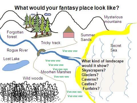
2 Digimap for Schools Geography Resources Title: Fantasy maps Level Context Location Secondary Imaginary mapping: features and keys Can be related to anywhere and can draw on different kinds of landscape features. Knowledge / skills Curriculum links (England) Curriculum links (Wales) Scottish Curriculum for Excellence Using a key/reading and interpreting maps/using the Scale tool Use maps and digital/computer mapping to describe features studied Use maps, imagery and ICT to find and present locational information Social Studies Outcomes: People, Place and Environment: 2-10a, 2-14a Activity Using knowledge of landscape and mapping features to create a map of an imaginary place Introduction Creating a map of an imaginary place helps pupils to apply some of their knowledge about maps. We all have favoured kinds of places and landscapes and for children this may be a theme park, a busy shopping centre, a zoo, a sandy beach, a mountain railway and so on. In this activity children have to recap how different kinds of landscape features are represented and get inspiration from Digimap for Schools to draw and create their own map using their own and Ordnance Survey symbols. Main activity If your pupils could create a fantasy place what would it look like? Would it be urban or rural? Or would it have both? What kind of landscape features would it have? Would it be by the sea or a river? Would there be woods or marshland? Would there be mountains or fields? Might it show a lighthouse or a castle? What would the features on the map be called? How would they show different features in a key?
3 You might want to have available some images of different kinds of landscape features and places and to have a range of map keys available (printed and laminated is a good idea) for pupils to use as they draw. Show all or some of the map extracts in the PowerPoint. These show different kinds of landscapes and features that might be included on a drawn map. There is also an example of a fantasy map. Taking it further In Digimap for Schools you can find places in the gazetteer that are unusual, quirky and sometimes strange. These can be a source of inspiration for map making. For example, the following places are all real places whose names fire the imagination. Make your own list of unusual place names and map their location: Slippery stones Wet Car Wood Deadman s Cove Baby s Hill Sockenholes Fm Cat Castle Shark s Fin Pricklegate Chimney Hill Scarlett Point Make 3D models of your fantasy place. Make another map to show what it might look like in five years time. Vote for the best fantasy place in the class. Give everyone one minute to describe it and say why it would be a good place to visit. Think about how you could make your place more environmentally friendly. What could be added? What might have to be taken away? Web links Maps and Stories as starters for mapping landscapes EDINA at University of Edinburgh 2016 This work is licensed under a Creative Commons Attribution-Non Commercial License

4 Fantasy Maps 1 Open Digimap for Schools and look for places where you ve been that you liked, perhaps somewhere you went on holiday? Or find somewhere that you ve seen on the television or read about. Zoom in to see what it looks like on a map. Use the Search box and the Scale toolbar to help you. 2 Take a note of any interesting names that you find that you might use. If you find a map view that gives you lots of ideas you could save it and print it out. 3 Draw your fantasy map using the map keys from Digimap for Schools to help you draw and mark features. Make a key on your map. Make up interesting place names for some of your map characteristics such as Mystery Mountain. 4 Describe your fantasy place and why you would like to be there.
5
My Geogr aphy Glasses
 My Geogr aphy Glasses Local area: places to play Paula Owens Geography teaching resource Primary Digimap for Schools Geography Resources Title: My Geography Glasses Level Context Location Primary Local
Landmarks Paula Owens 5 7 years
 Landmarks Paula Owens Geography teaching resource 5 7 years This is one of a series of teaching resources for use with Digimap for Schools. For more details about this service, visit http://digimapforschools.edina.ac.uk
Teifi Travels Social and environmental features along a river
 Teifi Travels Social and environmental features along a river Paula Owens Geography teaching resource Secondary Digimap for Schools Geography Resources Title: Teifi Travels Level Context Location Secondary
Where do I live? Geography teaching resource. Paula Owens. Primary. Locating own home address
 Where do I live? Locating own home address Paula Owens Geography teaching resource Primary Digimap for Schools Geography Resources Where do I live Level Context Location Primary Locating own home address
Picture Detectives. Geography teaching resource
 Picture Detectives Matching images and clues to map references Paula Owens Geography teaching resource Primary Digimap for Schools Geography Resources These resources are a guide for teachers to demonstrate
Transport, Travel and Trade. Geography teaching resource years. Paula Owens.
 http://digimapforschools.edina.ac.uk Transport, Travel and Trade Paula Owens Geography teaching resource 7-11 years This is one of a series of teaching resources for use with Digimap for Schools. For more
Map Detectives. Geography teaching resource. Paula Owens. Primary. Facts about Great Britain
 Map Detectives Facts about Great Britain Paula Owens Geography teaching resource Primary Digimap for Schools Geography Resources Title: Map Detectives Level Context Location Primary Facts about Great Britain
Geography Resources. Key Stage 1. Paula Owens
 Geography Resources Key Stage 1 :KR JRHV WR VFKRRO E\ ERDW" by Paula Owens About Digimap for Schools Digimap for Schools is an online mapping service for use by teachers and pupils providing easy access
Geography Resources. Paula Owens. Teifi Travels. Key Stage 2
 Geography Resources Key Stage 2 Teifi Travels by Paula Owens About Digimap for Schools Digimap for Schools is an online mapping service for use by teachers and pupils providing easy access to a range of
A new type of RICEPOTS
 A new type of RICEPOTS Alan Parkinson Geography teaching resource College Crown Copyright and Database Right 2014. Ordnance Survey (Digimap Licence) This is one of a series of teaching resources for use
MEADOWS PRIMARY SCHOOL and NURSERY GEOGRAPHY POLICY
 MEADOWS PRIMARY SCHOOL and NURSERY GEOGRAPHY POLICY Purpose of study The teaching of Geography at Meadows is done by following the 2014 National Curriculum. The planning and teaching of the subject aims
GEOGRAPHY POLICY STATEMENT. The study of geography helps our pupils to make sense of the world around them.
 GEOGRAPHY POLICY STATEMENT We believe that the study of geography is concerned with people, place, space and the environment and explores the relationships between the earth and its peoples. The study
St Joseph s R.C. Primary School. Policy for Geography
 St Joseph s R.C. Primary School Policy for Geography 2016-2017 This policy is written with consideration to our school commitment to the Rights of the Child and our achievement of becoming a Rights Respecting
Subject: Geography Scheme of Work: B1 to B6 Mastery tiles. Term: Autumn/Spring/Summer
 Subject: Geography Scheme of Work: B1 to B6 Mastery tiles Term: Autumn/Spring/Summer Topic / Unit(s) Overview / Context Introduction to geography. An introduction to geography including basic map skills
name and locate the world s seven continents and five oceans
 Subject: Geography Activities National Curriculum Objectives One Progression of Skills Name the 7 continents and 5 oceans 3D Jigsaw task to locate continents and seas name and locate the world s seven
Year 34 B2 Geography - Continents and Oceans 2018 Key Skills to be covered: Taken from Level 3 Taken from Level 4
 Key Skills to be covered: Taken from Level 3 Taken from Level 4 Geographical Enquiry: I ask, Which PHYSICAL features does this place have? I ask, Which HUMAN features does this place have? I give reasons
Walworth Primary School
 Walworth Primary School Date: April 2016 Revision Due: April 2017 Ref: L.Smith Geography Policy 1 Geography Policy Introduction A high quality geography education should inspire in pupils a curiosity and
Map reading made easy
 Map reading made easy 1 1. What is a map? A map is simply a drawing or picture (in 2-D) of a landscape or area of a country (in 3-D). It could be anything from a sketch map for a visitor to find your school
of places Key stage 1 Key stage 2 describe places
 Unit 25 Geography and numbers ABOUT THE UNIT This continuous unit aims to show how geographical enquiry can provide a meaningful context for the teaching and reinforcement of many aspects of the framework
Range of Opportunities
 Geograhy Curriculum Cropwell Bishop Primary School Range of Opportunities Year 1 Year 2 Year 3 Year 4 Year 5 Year 6 All Key Stage 1 Key Stage 2 Investigate the countries and capitals of the United Kingdom.
St John s Catholic Primary School. Geography Policy. Mission Statement
 St John s Catholic Primary School Geography Policy Mission Statement We at St John s strive for excellence in education by providing a safe, secure and caring family environment where individuals are valued
Lesson 2 DRAWING A SIMPLE MAP WALT: Draw a simple map. Lesson 3 DRAWING A MAP TO SCALE. scale map.
 Year 3 GEOGRAPHY Mapping Lesson 1 WHAT MAPS SHOW US WALT: Describe the purpose of a map. Lesson 2 DRAWING A SIMPLE MAP WALT: Draw a simple map. Lesson 3 DRAWING A MAP TO SCALE WALT: Draw a simple scale
HOLY CROSS CATHOLIC PRIMARY SCHOOL
 HOLY CROSS CATHOLIC PRIMARY SCHOOL Geography Policy Date Implemented Jan 17 Review Date Jan 22 Mission Statement Holy Cross Primary School is a Catholic School. We seek to provide a broad, balanced Christian
Teachers Resources: Set One
 Teachers Resources: Set One This is the first of two teachers resource packs created especially for Our Read 2011. These resources are ideal for inspiring preparatory work to be undertaken with pupils
Geography Policy. Introduction
 Geography Policy Introduction Geography at St. Aloysius Federation School teaches an understanding of places and environments and aims to inspire a curiosity and fascination about the world and its people.
Geography Policy 2014
 Geography Policy 2014 DEFINITION Geography education should inspire in pupils a curiosity and fascination about the world and its people that will remain with them for the rest of their lives. Teaching
ST AMBROSE CATHOLIC PRIMARY SCHOOL Geography Policy
 ST AMBROSE CATHOLIC PRIMARY SCHOOL Geography Policy 2017-2018 Our school policy is developed in accordance with the National Curriculum for Geography and Foundation Stage Curriculum for Understanding of
Geography. Programmes of study for Key Stages 1-3
 Geography Programmes of study for Key Stages 1-3 February 2013 Contents Purpose of study 3 Aims 3 Attainment targets 3 Subject content 4 Key Stage 1 4 Key Stage 2 5 Key Stage 3 6 2 Purpose of study A high-quality
Subject Progression Map
 Subject Progression Map On website Subject Name: Geography Vision-Taken from the National Curriculum A high-quality geography education should inspire in pupils a curiosity and fascination about the world
Map reading made easy
 Map reading made easy 1. What is a map? A map is simply a drawing or picture (in 2-D) of a landscape or area of a country (in 3-D). It could be anything from a sketch map for a visitor to find your school
Map reading made easy
 Map reading made easy Maps can be great fun and they can lead you to all sorts of discoveries. They can help you get to know an area really well, because they pinpoint interesting places that are often
Geography. Programme of study for key stage 3 and attainment target (This is an extract from The National Curriculum 2007)
") Geography Programme of study for key stage 3 and attainment target (This is an extract from The National Curriculum 2007) Crown copyright 2007 Qualifications and Curriculum Authority 2007 Curriculum aims
Geography Programme of study for key stage 3 and attainment target (This is an extract from The National Curriculum 2007) Crown copyright 2007 Qualifications and Curriculum Authority 2007 Curriculum aims
Abbotswood Junior School National Curriculum 2014
 Geography Purpose A high-quality geography education should inspire in pupils a curiosity and fascination about the world and its people that will remain with them for the rest of their lives. Teaching
Your web browser (Safari 7) is out of date. For more security, comfort and. the best experience on this site: Update your browser Ignore
 is out of date. For more security, comfort and. the best experience on this site: Update your browser Ignore") Your web browser (Safari 7) is out of date. For more security, comfort and lesson the best experience on this site: Update your browser Ignore Political Borders Why are the borders of countries located
Your web browser (Safari 7) is out of date. For more security, comfort and lesson the best experience on this site: Update your browser Ignore Political Borders Why are the borders of countries located
Sample assessment task. Task details. Content description. Year level 7
 Sample assessment task Year level 7 Learning area Subject Title of task Task details Description of task Type of assessment Purpose of assessment Assessment strategy Evidence to be collected Suggested
Tuition, Medical and Behaviour Support Service
 Tuition, Medical and Behaviour Support Service Curriculum Policy - Primary Geography Reviewed: October 2018 Next Review: October 2019 Responsibility: Andrea Snow AIMS AND PRINCIPLES The national curriculum
Map reading made easy
 Map reading made easy 1. What is a map? A map is simply a drawing or picture (in 2-D) of a landscape or area of a country (in 3-D). It could be anything from a sketch map for a visitor to find your school
Geography Curriculum Policy
 Geography Curriculum Policy Subject Leader: Jo Hamill From: September 2016 The Purpose of the Policy At Winlaton West Lane Primary, we aim to deliver a high-quality Geography education should inspire in
Class 4J Autumn Term St. Lucia Adapted from QCA Geography Unit 10 incorporating some elements of Unit 25
 Class 4J Autumn Term 2002 Geography St. Lucia Geography Unit 10 incorporating some elements of Unit 25 ABOUT THE UNIT In this unit children develop ideas about a less economically developed country. When
BLACK PEAR TRUST SUBJECT PLAN - GEOGRAPHY
 Purpose of Study A high-quality geography education should inspire in pupils a curiosity and fascination about the world and its people that will remain with them for the rest of their lives. Teaching
ESEU Workshop Learning Outcomes. PRIMARY (England, Northern Ireland and Wales) KS1. Lower KS2. Upper KS2
 KS1. Lower KS2. Upper KS2") PRIMARY (England, Northern Ireland and Wales) KS1 Rock circus (for years 1/2) insights into how minerals, rocks, fossils and other things found in the ground can be sorted, classified and identified most
PRIMARY (England, Northern Ireland and Wales) KS1 Rock circus (for years 1/2) insights into how minerals, rocks, fossils and other things found in the ground can be sorted, classified and identified most
The maps in this resource can be freely modified and reproduced in the classroom only.
 Teacher's Notes In this activity, students work collaboratively to explore sections of old and new maps. By closely examining these documents, students learn to see maps as more than just tools for locating
Teaching Resource for KS2 Investigating Rivers
 Teaching Resource for KS2 Investigating Rivers The Parrett Catchment Project Edited by Sam Woodhouse Page 2 Scheme of Work Investigating Rivers An adaptation of the KS2 unit on rivers and water About this
HAREWOOD JUNIOR SCHOOL KEY SKILLS
 HAREWOOD JUNIOR SCHOOL KEY SKILLS Geography Purpose of study A high-quality geography education should inspire in pupils a curiosity and fascination about the world and its people that will remain with
Your web browser (Safari 7) is out of date. For more security, comfort and. the best experience on this site: Update your browser Ignore
 is out of date. For more security, comfort and. the best experience on this site: Update your browser Ignore") Your web browser (Safari 7) is out of date. For more security, comfort and Activityengage the best experience on this site: Update your browser Ignore Comparing Historical Maps How can historical maps
Your web browser (Safari 7) is out of date. For more security, comfort and Activityengage the best experience on this site: Update your browser Ignore Comparing Historical Maps How can historical maps
WHITEHILLS PRIMARY SCHOOL. putting children first. GEOGRAPHY POLICY
 WHITEHILLS PRIMARY SCHOOL putting children first. GEOGRAPHY POLICY Reviewed and agreed by Governors January 2015 1 Introduction This policy outlines the teaching, organisation and management of the geography
Use maps, atlases, globes and computer mapping to locate countries and describe features studied
 Roseberry Primary School Curriculum planning Lead Question: What s so amazing about America? National Curriculum driver: Geography Rationale statement: In this study about the amazing Americas, children
Avalon Marshes Landscape
 Avalon Marshes Landscape Mapping the Marshes KS2 & KS3 Outline The Avalon Marshes is a unique and interesting landscape and this set of resources is designed to help Description pupils interact with the
Progression of skills in Geography
 New Curriculum Holy Trinity CE Primary Academy 2013-14 Subject: Geography Skills: Progression of skills in Geography Geographical enquiry Teacher led enquiries, to ask and respond to simple closed questions.
GEOGRAPHY POLICY. Date: March Signed: Review: March 2019
 GEOGRAPHY POLICY Date: March 2018 Signed: Review: March 2019 Aims At Hayton C of E Primary School we believe that Geography is an essential part of the curriculum and teachers ensure that the children
Risky world. What is risk? Is our local area a risky place? To understand what is meant by risky places
 Lesson 1: Is our local area a risky place? Place - geographical imaginations, physical and human characteristics of real places. Space spatial patterns and distributionsd Scale making links between scales
Our Lady Immaculate Catholic Primary School History and Geography Curriculum Map Would the Bog Baby survive in Liverpool?
 Year 1 and 2 - *Year 1 and 2 work on a two year cycle due to mixed classes Autumn 1 National Curriculum link: Human and physical geography - identify seasonal and daily weather patterns in the United Kingdom
North Carolina Essential Standards Kindergarten Social Studies
 North Carolina s Kindergarten Social Studies Kindergarten through second grade students are introduced to an integrative approach of Social Studies by exploring aspects of self, others, families and communities
Children needing support to achieve key skills. Children surpassing key skills. Geography Progression in Skills Key Stage One. Locational Knowledge
 Skills Locational Knowledge Geography Progression in Skills Key Stage One Children needing support to achieve key skills Children surpassing key skills To understand that the world extends outside their
Gedney Church End and Lutton St Nicholas Federated Primary Schools. Geography Policy
 Gedney Church End and Lutton St Nicholas Federated Primary Schools Geography Policy Contents: Introduction Expectations in Key Stage 1 Expectations in Key Stage 2 Aims Teaching and Learning Key Skills
Map reading made easy
 Map reading made easy 1. What is a map? A map is simply a drawing or picture (in 2-D) of a landscape or area of a country (in 3-D). It could be anything from a sketch map for a visitor to find your school
KS1. Geography Progression of Knowledge, Understanding and Skills WIJPS
 Geography Progression of Knowledge, Understanding and Skills WIJPS Geography inspires pupils to delve deeper and with more curiosity and fascination into the world around them and its people. The knowledge
Class 4J Spring Term Irian Jaya/Papua New Guinea Adapted from QCA Geography Unit 10 incorporating some elements of Unit 25
 Class 4J Spring Term 2003 Geography Irian Jaya/Papua New Guinea Geography Unit 10 incorporating some elements of Unit 25 ABOUT THE UNIT In this unit children develop ideas about a less economically developed
Many Ways to Name a Place
 Your web browser (Safari 7) is out of date. For more security, comfort and Activityapply the best experience on this site: Update your browser Ignore Many Ways to Name a Place What are the names for the
GEOGRAPHY CURRICULUM OVERVIEW
 GEOGRAPHY CURRICULUM OVERVIEW Geographical knowledge Progression Statement Autumn Spring Summer Year 1 UK and Local Area: Physical Themes: Name, locate and identify characteristics of the 4 countries and
Using OS Resources - A fieldwork activity for Key Stage 2
 Using OS Resources - A fieldwork activity for Key Stage 2 Liz Spincer, Saltford CE Primary School Outline of the fieldwork project: This series of activities was designed to illustrate how Primary School
Your web browser (Safari 7) is out of date. For more security, comfort and the best experience on this site: Update your browser Ignore
 is out of date. For more security, comfort and the best experience on this site: Update your browser Ignore") Your web browser (Safari 7) is out of date. For more security, comfort and the best experience on this site: Update your browser Ignore Activitydevelop EXPLO RING PL ACE IN THE CHES APEAKE BAY WATERSHED
Your web browser (Safari 7) is out of date. For more security, comfort and the best experience on this site: Update your browser Ignore Activitydevelop EXPLO RING PL ACE IN THE CHES APEAKE BAY WATERSHED
locate the world s countries, using maps to focus on Europe (including the location of
 Year 3 and 4 Geography study- Autumn 2 2017 National curriculum: Locational knowledge locate the world s countries, using maps to focus on Europe (including the location of Russia) and North and South
Geography Progression
 Geography Progression This document aims to track expectations for History within George Grenville Academy. What the National Curriculum says: KS1: Locational Knowledge: Name and locate the world s 7 continents
Pikes Lane Primary School. Geography Statement of Practice
 Pikes Lane Primary School Geography Statement of Practice Subject Leader: Mrs Cawley Subject Link Governor: Mr Scholar & Mrs Azad Last Updated: September 2016 Review Date: September 2017 Aims and objectives
iv vi x Using maps 2 Using images and analysing data 6 Using new technologies in geography 8
 Contents Exam board specification map Introduction Topic checker iv vi x Geographical skills Using maps 2 Using images and analysing data 6 Using new technologies in geography 8 Natural hazards Tectonic
Expanding Canada s Rail Network to Meet the Challenges of the Future
 Expanding Canada s Rail Network to Meet the Challenges of the Future Lesson Overview Rail may become a more popular mode of transportation in the future due to increased population, higher energy costs,
Holy Trinity 3-16 School. Geography Overview (Primary)
") Holy Trinity 3-16 School Key Stage 1 Geography Overview (Primary) Year Autumn 1 Autumn 2 Spring1 Spring 2 Summer 1 Summer 2 Y1 Dear Zoo Castles Gadgets and Gizmos (UK) Name, locate and identify characteristics
Holy Trinity 3-16 School Key Stage 1 Geography Overview (Primary) Year Autumn 1 Autumn 2 Spring1 Spring 2 Summer 1 Summer 2 Y1 Dear Zoo Castles Gadgets and Gizmos (UK) Name, locate and identify characteristics
Module 4 Educator s Guide Overview
 Module 4 Educator s Guide Overview Paths Module Overview This module looks at many different kinds of paths and considers why paths are where they are and how they look from space. Paths are usually not
Map reading made easy
 Map reading made easy Maps can be great fun and they can lead you to all sorts of discoveries. They can help you get to know an area really well, because they pinpoint interesting places that are often
Wednesday 8 June 2016 Afternoon
 Oxford Cambridge and RSA H Wednesday 8 June 2016 Afternoon GCSE GEOGRAPHY A A732/02 Geographical Skills (Higher Tier) *4410185572* Candidates answer on the Question Paper. OCR supplied materials: An Insert
Your web browser (Safari 7) is out of date. For more security, comfort and. the best experience on this site: Update your browser Ignore
 is out of date. For more security, comfort and. the best experience on this site: Update your browser Ignore") Your web browser (Safari 7) is out of date. For more security, comfort and Activitydevelop the best experience on this site: Update your browser Ignore Places in the Park Why do we use symbols? Overview
Your web browser (Safari 7) is out of date. For more security, comfort and Activitydevelop the best experience on this site: Update your browser Ignore Places in the Park Why do we use symbols? Overview
STAG LANE JUNIOR SCHOOL GEOGRAPHY POLICY
 Status-Recommended Prepared by: Megha Visavadia Date written January 2017 Shared with staff: Spring 2017 STAG LANE JUNIOR SCHOOL GEOGRAPHY POLICY Shared with governors: Spring 2018 Date for review: July
Of topic specific knowledge and understanding To encourage progressive development in 'thinking geographically'
 [August 2012] Content exemplars 1. Broad description of the content: Single paragraph, written with technical precision Content rigour (avoiding generic statements) Identifying the core of essential knowledge
Geography Long Term Plan 2018
 Geography Long Term Plan 2018 Geography Co-ordinator: Megan Frost A high-quality geography education should inspire in pupils a curiosity and fascination about the world and its people that will remain
Manor Primary School
 Geography Year 1: Where in the world is Barnaby Bear? Overview of the Learning: In this unit of learning pupils will use a first-hand object Barnaby the teddy bear to learn about other countries and places.
Geo-gnome geography: a curriculum-making invitation to all. Sharon Witt and Helen Clarke April 2017
 Geo-gnome geography: a curriculum-making invitation to all Sharon Witt and Helen Clarke April 2017 Welcome to the #geognome geography workshop 1. Introductions 2. Why #geognome geography? Share our gnomifesto
Sherwood Primary School POLICY FOR GEOGRAPHY
 Sherwood Primary School POLICY FOR GEOGRAPHY JUNE 2015 POLICY FOR GEOGRAPHY Purpose of study A high-quality geography education should inspire in pupils a curiosity and fascination about the world and
Witchampton CofE First School Geography Curriculum Map
 2016-2017 Autumn People and : 30-50 Show interest in the lives of people who are familiar to them. Shows interest in different occupations. Remembers and talks significant events in their own experience.
GeographyOverview Breadth of Study. Autumn Spring Summer
 Reception GeographyOverview Breadth of Study Geography National Curriculum coverage in the Creative Curriculum Autumn Spring Summer Comment and ask questions about aspects of their familiar world such
Geography Mile Post 1
 Mile Post 1 Use world maps, atlases and globes to identify the UK and its countries, as well as the countries, continents and oceans studied at this key stage Key Skills IPC learning Goals 1.11 Be able
APPLIED FIELDWORK ENQUIRY SAMPLE ASSESSMENT MATERIALS
 GCSE GEOGRAPHY B Sample Assessment Materials 85 GCSE GEOGRAPHY B COMPONENT 3 APPLIED FIELDWORK ENQUIRY SAMPLE ASSESSMENT MATERIALS 1 hour 30 minutes For examiner s use only SPaG Part A 18 0 Part B 18 0
Geography Skills Progression. Eden Park Primary School Academy
 Geography Skills Progression Eden Park Primary School Academy In order to ensure broad and balanced coverage, we follow these principles: Within each phase, geography is a driver for at least 3 Learning
Your web browser (Safari 7) is out of date. For more security, comfort and. the best experience on this site: Update your browser Ignore
 is out of date. For more security, comfort and. the best experience on this site: Update your browser Ignore") Your web browser (Safari 7) is out of date. For more security, comfort and Activitydevelop the best experience on this site: Update your browser Ignore Introduction to Population Density How can you figure
Your web browser (Safari 7) is out of date. For more security, comfort and Activitydevelop the best experience on this site: Update your browser Ignore Introduction to Population Density How can you figure
THORPE HESLEY PRIMARY SCHOOL Topic Term Planning. Geography and History
 WEEK Hook for Learning. LEARNING OBJECTIVE (NATIONAL CURRICULUM OR CHRIS QUIGLY) To ask and answer geographical questions about the physical characteristics of a location. Explain own views about locations.
Geography Route Planner
 Geography Route Planner Introduction to Route Planners Route Planners outline the Key Stages 1-3 curriculum to be taught within each campus of the Bury St Edmunds Trust. Each Route Planner has been designed
GREAT BRITAIN: INDUSTRIAL REVOLUTION TO 1851 Student Worksheet
 GREAT BRITAIN: INDUSTRIAL REVOLUTION TO 1851 Student Worksheet Theme of Map This thematic map captures the industrial development of Britain at a time when it had transformed the British economy and society.
34 A SPRING 1 GEOGRAPHY
 Year ¾ Key Skills to be covered, taken from National Curriculum pitching at the correct year group and differentiation within plan for different groups Be specific in the key skills, and make them more
Canadian Explorers. Learning object La Vérendyre map
 Canadian Explorers Learning object La Vérendyre map Lesson overview Students will be inspired by La Vérendyre to become explorers themselves. Students will embark on a research expedition to discover the
Get to Know Your Watershed
 engaging learners exploring watersheds connecting communities Get to Know Your Watershed QUESTION(S) What is a watershed? Where is my watershed? Author(s): Beth Bisson, Maine Sea Grant Program; Sandy Daniel,
Course Title: Social Studies People We Know Grade: 2
 Course Title: People We Know Grade: 2 Credits: 1.0 Lessons per week: 2/3 (total 36 weeks) Subject Philosophy: Course Summary: is a vehicle for examining and developing our own biblical worldview and exploring
Map Makers 2nd Grade
 Map Makers 2nd Grade Students use mapmaking to develop science and social studies concepts and practice map skills while developing a sense of place and a connection to the property. Concepts of landforms,
Mystery Images from Space Educator s Guide
 Mystery Images from Space Educator s Guide Summary: Students learn and reinforce core concepts in Earth science and achieve learning goals in other fields as well by exploring photographs taken by astronauts.
HOW TO IMPROVE LINKS BETWEEN SCHOOL GEOGRAPHY DEPARTMENTS AND LOCAL UNIVERSITY GEOGRAPHY and EDUCATION DEPARTMENTS
 CGEOG (TEACHER) ONLINE CPD MODULE HOW TO IMPROVE LINKS BETWEEN SCHOOL GEOGRAPHY DEPARTMENTS AND LOCAL UNIVERSITY GEOGRAPHY and EDUCATION DEPARTMENTS By Garry Atterton Chartered Geographer (Teacher) The
Analysing changes in features and landscapes:
 Analysing changes in features and landscapes: This activity will guide you through the process of map regression in an urban area. Map regression is the study of a sequence of maps to reveal changes in
YEAR 7 REVISION BOOKLET
 YEAR 7 REVISION BOOKLET Assessment checklist 1. To be able to define Geography. 2. Give examples of what we study in geography 3. Group what we study into the three major areas of geography 4. To be able
Edexcel A GCSE Geography Course Options For teaching from September 2016
 Edexcel A GCSE Geography Course Options For teaching from September 2016 lies in a secluded valley at the eastern edge of Exmoor National Park. The house is a striking example of a Tudor and Georgian country
Balby Central Primary Long Term Plan Year: 1. Term 1(8weeks) 2 (7 weeks) 3 (5 weeks) 4 (5 weeks) 5 (7 weeks) 6 (7 weeks)
 2 (7 weeks) 3 (5 weeks) 4 (5 weeks) 5 (7 weeks) 6 (7 weeks)") Balby Central Primary Long Term Plan 2017-2018 Year: 1 Term 1(8weeks) 2 (7 weeks) 3 (5 weeks) 4 (5 weeks) 5 (7 weeks) 6 (7 weeks) Subject focus History / DT Geography / Art History / Art DT ART Geography
Balby Central Primary Long Term Plan 2017-2018 Year: 1 Term 1(8weeks) 2 (7 weeks) 3 (5 weeks) 4 (5 weeks) 5 (7 weeks) 6 (7 weeks) Subject focus History / DT Geography / Art History / Art DT ART Geography
Geography Policy. for Hertsmere Jewish Primary School
 Geography Policy for Hertsmere Jewish Primary School Reviewed by: L Rubin Reviewed on: September 2017 Date of Next Review: September 2018 Policy Review This policy will be reviewed in full by the Governing
Oakland Unified School District. Worksheet To Accompany USGS Map Adventures Teaching Packet
 Worksheet To Accompany USGS Map Adventures Teaching Packet Lesson 4: Symbols and Legends This is the overhead view of the park that Nikki saw from the balloon. Usually maps do not show all of the things