Andrea Bonomi, Glauco Mantegari CSAI Research Center Università di Milano-Bicocca
|
|
|
- Elmer Gibson
- 6 years ago
- Views:
Transcription
1 Le esperienze in corso: Archeoserver e la condivisione di dati e informazioni Andrea Bonomi, Glauco Mantegari CSAI Research Center Università di Milano-Bicocca
2 GIS as a platform for Po-BASyN


3 GIS as a platform for Po-BASyN Mobile GIS Local desktop GIS WebGIS
4 GIS as a platform for Po-BASyN A broadly interdisciplinary research project: huge amount of heterogeneous data need for high accuracy and completeness Main GIS functionalities [after Raper and Maguire, 1992]: acquisition structuration manipulation query and analysis presentation and navigation Collaboration among researchers becomes fundamental on two levels: data sharing analytical procedures sharing + the Web = WebGIS geodata sharing Towards a collaborative platform based on Web technologies
5 GIS as a platform for Po-BASyN PUBLISHED DATA LOCAL DESKTOP GIS WEB GIS
6 WebGIS architecture HTTP Request WEB browser user interface Javascript calls HTML CSS XML Data, Images ArchaeoGEW, il WebGIS archeologico del parco Spina Verde di Como (Laboratorio di Geomatica del Politecnico di Como) ArchaeoBrowser un servizio di cartografia tematica, che consente di consultare dati sulle risorse archeologiche presenti nel territorio della provincia di Bolzano (Ufficio Beni Archeologici della Provincia Autonoma di Trento e Bolzano Fasti on-line (Associazione Internazionale di Archeologia Classica) Appia Antica Project (CNR-ITABC, Virtual Heritage Lab) Archeo WebGIS, progetto di applicazione WebGIS all'interno del progetto AlpiNet FAIS (Fayyum Archaeological Information System - dell'università di Lecce) WebGIS degli insediamenti,del progetto LandLab (Università di Lecce) WebGIS della Valle del Metauro, che propone alcuni tematismi di carattere archeologico
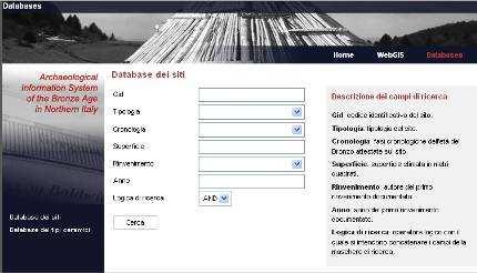
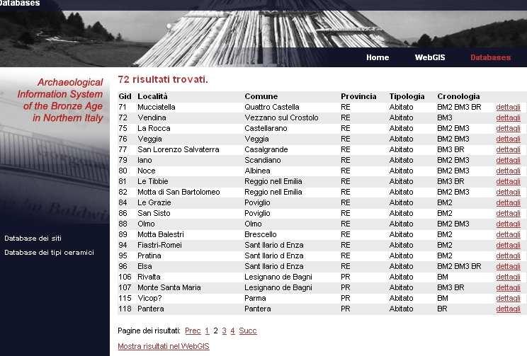
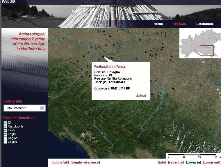
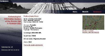
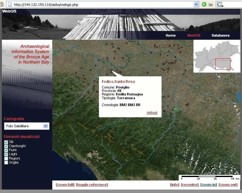
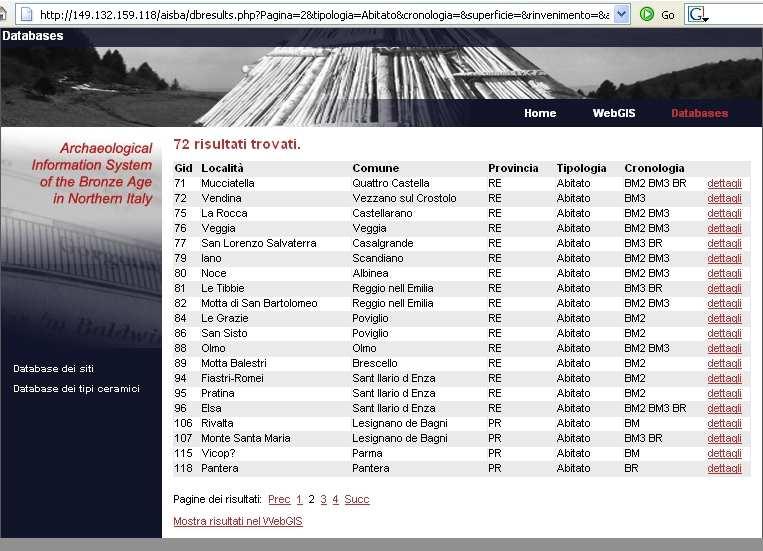
7 WebGIS navigation: an example Database search Results list Map Site details
8 WebGIS main Functionalities Digital Library helping users to find information about scientific publications e-library Ceramic types Db Collaborative editing platform for Archaeology researcher and students Online database of ceramic type collections Sites Db WebGIS of Bronze Age sites in northern Italy Web GIS Online database of Bronze Age sites in northern Italy
9 e-library In order to effectively describe contents beyond a keyword based approach, and to support effective forms of information retrieval, users must have available a domain ontology whose elements can be selected as indicators of the topics treated in the publications Example Searching for: Sicily, Bronze Age The system will retrieve the article The early bronze age Village of Mursia annotated as Mursia, Early Bronze Age partof Sicily Bronze Age Pantelleri a partof partof Early Bronze Age Mursia period place Publication: The early bronze age Village of Mursia
10 Historical Historical period period Thing Thing e-library Ontology The ontology has to be designed by archaeology professors and researchers with the aid of knowledge engineers. The e-library provides on-line tool to maintain and evolve the ontology. Activity Activity Analysis Analysis Item Item Ontology main classes Culture Culture Typology Typology Figure Figure Place Place Material Material Metal Site Material Site type type Item Item type type Social Social organizatio organizatio n Structure Structure type type Details of the relations of Item type class Geographi Geographi cc Typology Analysis Place Place subclassof Site analyze Site Structure Structure Activity Historical period isusedfor period Details of the relations of Sword individual Item type Item type instanceof instanceof instanceof hassupertype isbuildof Weapon Sword hassupertype isbuildof Material hasitemtype Item
11 e-library Web Interface The e-library allows content editors to describe semantically all the publications in a collaborative and simple way, by adopting a simple web-based user interface. In particular this description will be performed manually by the students, while archaeology professors and researchers will supervise the work and will progressively refine/maintain the domain ontology. Annotation Query
12 ArcheoServer.it In 2005, the chair of Prehistory and Protohistory - University of Milan, the Department of Informatics, Systems and Communication - University of Milan- Bicocca and the Department of Archaeology - University of Bologna, have started a long-term project for the creation of a set of Web-oriented services aimed at supporting the sharing of knowledge on prehistory and protohistory in Italy. The main objective is the creation of a Web portal which will provide a collaborative platform for the exchange of scientific information among the communities of Italian archaeology researchers. Chair of Prehistory and Protohistory University of Milan Department of Archaeology University of Bologna Published data ArcheoServer Artificial Intelligence Laboratory - Department of Informatics, Systems and Communication University of Milan- Bicocca
13 ArcheoServer Areas Research e-library Methodology RSS Publications, links, News
14 Navigation details Sites Search Web GIS e-library Show details Places / publications Publication Sites / Web GIS Show details Sites / publications Search publications Ceramic types Search Show publication ceramic types Show types distribution Show details Show site ceramic types Show publications Show site details Site Ceramic type
 framework developed by the Fraunhofer Institut NavEditOW - a")

15 Architecture & Standards The ArcheoServer portal is based on: SnipSnap - a wiki (collaborative web) framework developed by the Fraunhofer Institut NavEditOW - a web-based ontology navigation, editing and querying application in developing by LIntAr Architecture Open System, Information Exchange W3c Semantic Web Cake Standards


16 Research directions Semantic Querying Ontology mapping Ontology Heterogeneous Published data data sources + Mediator ArcheoServer
The Process of Spatial Data Harmonization in Italy. Geom. Paola Ronzino
 The Process of Spatial Data Harmonization in Italy Geom. Paola Ronzino ISSUES Geospatial Information in Europe: lack of data harmonization the lack of data duplication of data CHALLENGES Challenge of INSPIRE:
WEB-BASED SPATIAL DECISION SUPPORT: TECHNICAL FOUNDATIONS AND APPLICATIONS
 WEB-BASED SPATIAL DECISION SUPPORT: TECHNICAL FOUNDATIONS AND APPLICATIONS Claus Rinner University of Muenster, Germany Piotr Jankowski San Diego State University, USA Keywords: geographic information
These modules are covered with a brief information and practical in ArcGIS Software and open source software also like QGIS, ILWIS.
 Online GIS Training and training modules covered are: 1. ArcGIS, Analysis, Fundamentals and Implementation 2. ArcGIS Web Data Sharing 3. ArcGIS for Desktop 4. ArcGIS for Server These modules are covered
Sapienza per la città intelligente
 Titolo presentazione La Resilienza delle città: Il Progetto RECIPE, REsilience in art Sapienza per la città intelligente un processo di condivisione di contenuti, conoscenze, tecnologie e progettualità,
GeoSUR SRTM 30-m / TPS
 GeoSUR SRTM 30-m / TPS Wm Matthew Cushing (USGS) 16 May 2013 U.S. Department of the Interior U.S. Geological Survey SRTM Mission Shuttle Radar Topography Mission (SRTM) Space Shuttle Endeavour during the
CRMarchaeo: A CIDOC CRM extension to support archaeological excavations
 CRMarchaeo: A CIDOC CRM extension to support archaeological excavations Achille Felicetti VAST-LAB, PIN, Università degli Studi di Firenze, Italy Archaeology and heterogeneity Archaeological excavation
Basics of GIS reviewed
 Basics of GIS reviewed Martin Breunig Karlsruhe Institute of Technology martin.breunig@kit.edu GEODETIC INSTITUTE, DEPARTMENT OF CIVIL ENGINEERING, GEO AND ENVIRONMENTAL SCIENCES, CHAIR IN GEOINFORMATICS
Regione Umbria. ESRI EMEA User Conference 2010 Rome, October 27th 2010
 Direzione Ambiente, Territorio e Infrastrutture Servizio Informatico/Informativo: geografico, ambientale e territoriale ESRI EMEA User Conference 2010 Rome, October 27th 2010 Arch. Ambra Ciarapica, Dott.
How local communities could profit from Habitats infrastructure
 Social Validation of INSPIRE Annex III Data Structures in EU Habitats How local communities could profit from Habitats infrastructure Andrea Scianna ( Icar CNR Italy ) consultant for Madonie Park Authority
PaikkaOppi - a Virtual Learning Environment on Geographic Information for Upper Secondary School
 PaikkaOppi - a Virtual Learning Environment on Geographic Information for Upper Secondary School Jaakko Kähkönen*, Lassi Lehto*, Juha Riihelä** * Finnish Geodetic Institute, PO Box 15, FI-02431 Masala,
4D information management system for road maintenance using GIS
 icccbe 2010 Nottingham University Press Proceedings of the International Conference on Computing in Civil and Building Engineering W Tizani (Editor) 4D information management system for road maintenance
Economic and Social Council
 United Nations Economic and Social Council Distr.: General 23 May 2012 Original: English E/CONF.101/100 Tenth United Nations Conference on the Standardization of Geographical Names New York, 31 July 9
A TECHNOLOGICAL INFRASTRUCTURE FOR CULTURAL TOURISM
 Abstract A TECHNOLOGICAL INFRASTRUCTURE FOR CULTURAL TOURISM L. Bordoni 1 Cultural assets are an expression of a country s artistic and historical heritage, and are custodians of its identity. This heritage
Experiences and Directions in National Portals"
 FIG Seminar on e-land Administration Innsbruck/Austria 2-4 June 2004 "ESRI's Experiences and Directions in National Portals" Kevin Daugherty Cadastral/Land Records Manager ESRI Topic Points Technology
From Research Objects to Research Networks: Combining Spatial and Semantic Search
 From Research Objects to Research Networks: Combining Spatial and Semantic Search Sara Lafia 1 and Lisa Staehli 2 1 Department of Geography, UCSB, Santa Barbara, CA, USA 2 Institute of Cartography and
A Spatial Data Infrastructure for Landslides and Floods in Italy
 V Convegno Nazionale del Gruppo GIT Grottaminarda 14 16 giugno 2010 A Spatial Data Infrastructure for Landslides and Floods in Italy Ivan Marchesini, Vinicio Balducci, Gabriele Tonelli, Mauro Rossi, Fausto
ArchaeoKM: Managing Archaeological data through Archaeological Knowledge
 Computer Applications and Quantitative Methods in Archeology - CAA 2010 Fco. Javier Melero & Pedro Cano (Editors) ArchaeoKM: Managing Archaeological data through Archaeological Knowledge A. Karmacharya
Innovation. The Push and Pull at ESRI. September Kevin Daugherty Cadastral/Land Records Industry Solutions Manager
 Innovation The Push and Pull at ESRI September 2004 Kevin Daugherty Cadastral/Land Records Industry Solutions Manager The Push and The Pull The Push is the information technology that drives research and
THE WASHINGTON COASTAL ATLAS
 THE ICAN COASTAL ATLAS MEDIATOR PROTOTYPE AND CONNECTING THE WASHINGTON COASTAL ATLAS Liz O Dea 1, Yassine Lassoued 2, Tanya Haddad 3, Declan Dunne 2 1 GIS Services Unit, WA State Dept. of Ecology 2 Coastal
ArcGIS. for Server. Understanding our World
 ArcGIS for Server Understanding our World ArcGIS for Server Create, Distribute, and Manage GIS Services You can use ArcGIS for Server to create services from your mapping and geographic information system
Framework for on an open 3D urban analysis platform based on OGC Web Services
 Platzhalter für Bild, Bild auf Titelfolie hinter das Logo einsetzen Framework for on an open 3D urban analysis platform based on OGC Web Services Marc-O. Löwner & Thomas Adolphi (née Becker) Technische
AperTO - Archivio Istituzionale Open Access dell'università di Torino
 AperTO - Archivio Istituzionale Open Access dell'università di Torino Android applications are inspired by Multi-Agent Systems This is the author's manuscript Original Citation: Android applications are
Why GIS & Why Internet GIS?
 Why GIS & Why Internet GIS? The Internet bandwagon Internet mapping (e.g., MapQuest) Location-based services Real-time navigation (e.g., traffic) Real-time service dispatch Business Intelligence Spatial
Leitner Helmuth Rizzolli Susanne Zambaldi Martin AUTONOME PROVINZ BOZEN SÜDTIROL PROVINCIA AUTONOMA DI BOLZANO ALTO ADIGE
 AUTONOME PROVINZ BOZEN SÜDTIROL Abteilung 9 Informationstechnik Amt 9.6 Amt für raumbezogene und statistische Informatik PROVINCIA AUTONOMA DI BOLZANO ALTO ADIGE Department 9 Information Technology Office
Dynamic Maps and Historical Context
 Dynamic Maps and Historical Context Jeanette Zerneke International Joint GIS-IDEAS and PNC/ECAI Conference December 2008 Dynamic Maps Roles and Functions of Dynamic Maps in Cultural Collections and Atlases
Enabling ENVI. ArcGIS for Server
 Enabling ENVI throughh ArcGIS for Server 1 Imagery: A Unique and Valuable Source of Data Imagery is not just a base map, but a layer of rich information that can address problems faced by GIS users. >
What is GIS and How Can It Help Me?
 esri European User Conference Madrid 2011 What is GIS and How Can It Help Me? Jaime Nieves Ignacio Vázquez esri spain «Knowing where things are, and why, is essential to rational decision making.» Jack
SITR-IDT The Spatial Data Infrastructure of Sardinia Region
 ITALY LOCAL AUTHORITY FOR MUNICIPALITIES, FINANCES AND URBAN PLANNING REGIONAL DEPARTMENT FOR CARTOGRAPHY AND INFORMATION SYSTEMS SITR-IDT The Spatial Data Infrastructure of Sardinia Region Content of
COURSE CONTENT for Computer Science & Engineering [CSE]
![COURSE CONTENT for Computer Science & Engineering [CSE]](/thumbs/92/110586049.jpg "COURSE CONTENT for Computer Science & Engineering [CSE]") COURSE CONTENT for Computer Science & Engineering [CSE] 1st Semester 1 HU 101 English Language & Communication 2 1 0 3 3 2 PH 101 Engineering Physics 3 1 0 4 4 3 M 101 Mathematics 3 1 0 4 4 4 ME 101 Mechanical
COURSE CONTENT for Computer Science & Engineering [CSE] 1st Semester 1 HU 101 English Language & Communication 2 1 0 3 3 2 PH 101 Engineering Physics 3 1 0 4 4 3 M 101 Mathematics 3 1 0 4 4 4 ME 101 Mechanical
Personal Field Data Collection by UM-FieldGIS (Integration of Google Map API to Mobile GIS)
") Personal Field Data Collection by UM-FieldGIS (Integration of Google Map API to Mobile GIS) Ko Ko Lwin*. Yuji MURAYAMA* *Division of Spatial Information Science Graduate School of Life and Environmental
Personal Field Data Collection by UM-FieldGIS (Integration of Google Map API to Mobile GIS) Ko Ko Lwin*. Yuji MURAYAMA* *Division of Spatial Information Science Graduate School of Life and Environmental
Finding geodata that otherwise would have been forgotten GeoXchange a portal for free geodata
 Finding geodata that otherwise would have been forgotten GeoXchange a portal for free geodata Sven Tschirner and Alexander Zipf University of Applied Sciences FH Mainz Department of Geoinformatics and
Key Words: geospatial ontologies, formal concept analysis, semantic integration, multi-scale, multi-context.
 Marinos Kavouras & Margarita Kokla Department of Rural and Surveying Engineering National Technical University of Athens 9, H. Polytechniou Str., 157 80 Zografos Campus, Athens - Greece Tel: 30+1+772-2731/2637,
Thematic Maps for Geographical Information Search
 Thematic Maps for Geographical Information Search ABSTRACT Noemi Mauro University of Turin Computer Science Department Torino, Italy 10149 noemi.mauro@unito.it The exploration of cultural heritage information
Gistat: moving towards a location information management system
 Gistat: moving towards a location information management system (merging geographical, statistical and historical information) Pina Grazia Ticca Marco Ballin Istat - Italy Aguascalientes, Mexico 2-4 December
ESRI Survey Summit August Clint Brown Director of ESRI Software Products
 ESRI Survey Summit August 2006 Clint Brown Director of ESRI Software Products Cadastral Fabric How does Cadastral fit with Survey? Surveyors process raw field observations Survey measurements define high-order
Development and operation of GIS exercise materials for undergraduate students
 Development and operation of GIS exercise materials for undergraduate students Since around 2000, GIS researchers in Japan have collaborated to provide materials for GIS lecture classes for university
ArcGIS is Advancing. Both Contributing and Integrating many new Innovations. IoT. Smart Mapping. Smart Devices Advanced Analytics
 ArcGIS is Advancing IoT Smart Devices Advanced Analytics Smart Mapping Real-Time Faster Computing Web Services Crowdsourcing Sensor Networks Both Contributing and Integrating many new Innovations ArcGIS
Technical Specifications. Form of the standard
 Used by popular acceptance Voluntary Implementation Mandatory Legally enforced Technical Specifications Conventions Guidelines Form of the standard Restrictive Information System Structures Contents Values
Open data integration: from satellite to UAV for protection of built environment. The archaeological site in the Centa River bed in Albenga
 Open data integration: from satellite to UAV for protection of built environment. The archaeological site in the Centa River bed in Albenga L. Barazzetti a, R. Brumana a, B. Cuca a,b, M. Previtali a, R.
GIS Visualization: A Library s Pursuit Towards Creative and Innovative Research
 GIS Visualization: A Library s Pursuit Towards Creative and Innovative Research Justin B. Sorensen J. Willard Marriott Library University of Utah justin.sorensen@utah.edu Abstract As emerging technologies
LANDLAB PROJECT AND ARCHAEOLOGY ON-LINE. WEB-BASED SYSTEMS FOR THE STUDY OF SETTLEMENT PATTERNS AND EXCAVATION DATA IN CLASSICAL ARCHAEOLOGY
 Archeologia e Calcolatori 18, 2007, 243-254 LANDLAB PROJECT AND ARCHAEOLOGY ON-LINE. WEB-BASED SYSTEMS FOR THE STUDY OF SETTLEMENT PATTERNS AND EXCAVATION DATA IN CLASSICAL ARCHAEOLOGY 1. INTRODUCTION
THIS IS NOT A PRESENTATION
 THIS IS NOT A PRESENTATION IT IS AN INVITATION Background Objectives Project Profile Distributed Geodata Management Current Status Remarks Gunnar Misund Associate Professor Head of Environmental Computing
Quality of Information collected with the help of Map-Based Questionnaires
 Quality of Information collected with the help of Map-Based Questionnaires Contents 1. Introduction 2. Case Studie: The Switch Project in Wilhelmsburg 3. The Web Platform 1. Technical Architecture 2. Interactive
A Geographer s role in a Google Maps World. Jeremy Bartley ESRI
 A Geographer s role in a Google Maps World Jeremy Bartley ESRI 1 It is a good time to be a Geographer. 2 Microsoft, Google, Yahoo, and others are pushing geographic awareness to the general public Providing
Manual of Digital Earth
 V8.0 March 27, 2018 International Society for Digital Earth Manual of Digital Earth (Tentative Title) OUTLINE Foreword Chapter 1 Understanding Digital Earth 1.1 Origins and Precursors of Digital Earth
Dynamic Ontology Service for Historical Persons and Places Based on Crowdsourcing
 Dynamic Ontology Service for Historical Persons and Places Based on Crowdsourcing 22.1.2016, COST RRL WG2 Workshop Jouni Tuominen Semantic Computing Research Group (SeCo), http://seco.cs.aalto.fi, Aalto
The INSPIRE Community Geoportal
 Infrastructure for Spatial Information in the European Community The INSPIRE Community Geoportal Gianluca Luraschi EC INSPIRE GEOPORTAL TEAM European Commission Joint Research Centre Institute for Environment
Urban Planning Internet Geographic Information Systems Fall 2010
 Urban Planning - 794 Internet Geographic Information Systems Fall 2010 Instructor: Professor Huxhold (hux@uwm.edu) Lecturer: Melissa Mann (mmann@uwm.edu) Manager: Kurt Meingast (kurtm@uwm.edu) Schedule:
Geo-Information for the UN Agency for the Refugees (UNHCR) and its partners
 and its partners") Geo-Information for the UN Agency for the Refugees (UNHCR) and its partners Using geo-information for refugee operations 1. 2. http://geoportal.unhcr.org Development road map & Wish-list 3. Field Information
Geo-Information for the UN Agency for the Refugees (UNHCR) and its partners Using geo-information for refugee operations 1. 2. http://geoportal.unhcr.org Development road map & Wish-list 3. Field Information
USAGE OF OLD MAPS AND THEIR DISTRIBUTION WITHIN THE FRAME OF WEB MAP SERVICES
 USAGE OF OLD MAPS AND THEIR DISTRIBUTION WITHIN THE FRAME OF WEB MAP SERVICES Jiri Cajthaml, Jiri Krejci Czech Technical University in Prague, Faculty of Civil Engineering, Department of Mapping and Cartography,
The iplant Collaborative Semantic Web Platform
 The iplant Collaborative Semantic Web Platform W O R K S H O P O N S E M A N T I C S I N G E O S PAT I A L A R C H I T E C T U R E S : A P P L I C AT I O N S A N D I M P L E M E N TAT I O N O c t o b e
WEB MAP SERVICE (WMS) FOR GEOLOGICAL DATA GEORGE TUDOR
 FOR GEOLOGICAL DATA GEORGE TUDOR") WEB MAP SERVICE (WMS) FOR GEOLOGICAL DATA GEORGE TUDOR WEB MAP SERVICE (WMS) - GENERALITIES Projects with data from different sources Geological data are in different GIS software format Large amount of
WEB MAP SERVICE (WMS) FOR GEOLOGICAL DATA GEORGE TUDOR WEB MAP SERVICE (WMS) - GENERALITIES Projects with data from different sources Geological data are in different GIS software format Large amount of
Application of WebGIS and VGI for Community Based Resources Inventory. Jihn-Fa Jan Department of Land Economics National Chengchi University
 Application of WebGIS and VGI for Community Based Resources Inventory Jihn-Fa Jan Department of Land Economics National Chengchi University OUTLINE Introduction Methodology Results Conclusions 2 MOTIVATION
Cutting Edge Engineering for Modern Geospatial Systems Rear Admiral Dr. S Kulshrestha, retd
 Cutting Edge Engineering for Modern Geospatial Systems Rear Admiral Dr. S Kulshrestha, retd 11 Jun 2015 GeoIntelligence Asia 2015 The technology would become so pervasive that it becomes a part of you
D.T2.2.2 Methodological model for an integrated monitoring system D.T METHODOLOGICAL MODEL FOR AN INTEGRATED MONITORING SYSTEM
 D.T.2.2.2. METHODOLOGICAL MODEL FOR AN INTEGRATED MONITORING SYSTEM PP7 SPECTRA 04 2018 1 1.1 1.2 1.3 INDEX FOREWORD p.7 CHAPTER 1 FIRST STAGE p.13 CHAPTER 2 DATA COLLECTING 2.1 Selection of the monitored
Overview of Geospatial Open Source Software which is Robust, Feature Rich and Standards Compliant
 Overview of Geospatial Open Source Software which is Robust, Feature Rich and Standards Compliant Cameron SHORTER, Australia Key words: Open Source Geospatial Foundation, OSGeo, Open Standards, Open Geospatial
Global 3D Models with Local Content
 Gunnar Misund Associate Professor Head of Environmental Computing gunnar.misund@hiof.no - Morten Granlund, Scientfic Assistant Herman Kolås, Master Student Mats Lindh, Master Student - Østfold University
No. of Days. Building 3D cities Using Esri City Engine ,859. Creating & Analyzing Surfaces Using ArcGIS Spatial Analyst 1 7 3,139
 Q3 What s New? Creating and Editing Data with ArcGIS Pro Editing and Maintaining Parcels Using ArcGIS Spatial Analysis Using ArcGIS Pro User Workflows for ArcGIS Online Organizations Q3-2018 ArcGIS Desktop
LandEx A GeoWeb-based Tool for Exploration of Patterns in Raster Maps
 LandEx A GeoWeb-based Tool for Exploration of Patterns in Raster Maps T. F. Stepinski 1, P. Netzel 1,2, J. Jasiewicz 3, J. Niesterowicz 1 1 Department of Geography, University of Cincinnati, Cincinnati,
POSSIBILITY FOR APPLICATION OF GIS TECHNOLOGIES IN RTB BOR GROUP
 MINING AND METALLURGY INSTITUTE BOR UDK: 622 ISSN: 2334-8836 (Štampano izdanje) ISSN: 2406-1395 (Online) UDK: 681.33:622.343(045)=111 doi:10.5937/mmeb1603021v Nenad Vušović *, Marko Vuković **, Igor Svrkota
NOKIS an ISO Based Metadata System
 NOKIS an ISO 19115 Based Metadata System Carsten Heidmann BAW Hamburg (Tyskland) Overview Project NOKIS/NOKIS++ NOKIS Editor Metadata Infrastructure Germany NOKIS Tools: Survey Planning Tool Conclusions
Web Visualization of Geo-Spatial Data using SVG and VRML/X3D
 Web Visualization of Geo-Spatial Data using SVG and VRML/X3D Jianghui Ying Falls Church, VA 22043, USA jying@vt.edu Denis Gračanin Blacksburg, VA 24061, USA gracanin@vt.edu Chang-Tien Lu Falls Church,
GIS-based Smart Campus System using 3D Modeling
 GIS-based Smart Campus System using 3D Modeling Smita Sengupta GISE Advance Research Lab. IIT Bombay, Powai Mumbai 400 076, India smitas@cse.iitb.ac.in Concept of Smart Campus System Overview of IITB Campus
Linked Open Data From OGC Compliant Web Services: The Case of Regione Emilia - Romagna Geoportal
 Linked Open Data From OGC Compliant Web Services: The Case of Regione Emilia - Romagna Geoportal Inspire Conference Florence 26/06/2013 Giovanni Ciardi (Regione Emilia-Romagna) Alfredo Abrescia (Planetek
SPATIAL INFORMATION GRID AND ITS APPLICATION IN GEOLOGICAL SURVEY
 SPATIAL INFORMATION GRID AND ITS APPLICATION IN GEOLOGICAL SURVEY K. T. He a, b, Y. Tang a, W. X. Yu a a School of Electronic Science and Engineering, National University of Defense Technology, Changsha,
Spatial information sharing technology based on Grid
 Spatial information sharing technology based on Grid Hong-bin ZHANG a,b,c,1, Bao-rui CHEN a,b,c,3,gang LI b,c,2, Xiao-ping XIN a,b,c,* a Hulunber Grassland Ecosystem Observation and Research Station, Beijing
Open Geoportal lands to Europe: use cases and improvements from
 Free and Open Source Software for Geospatial (FOSS4G) Conference Proceedings Volume 17 FOSS4G 2017 Full Conference Proceedings (papers and posters), Boston, USA. Article 11 2017 : use cases and improvements
SDI Standards at work
 SDI Standards at work Jan Juul Jensen Senior Technology Strategist Informi GIS Denmark Informi GIS Private held Limited Company Specialized in GIS 100+ employees HQ in Charlottenlund, Copenhagen Regional
Enriching the GIScience Research Agenda: Fusing Augmented Reality (AR) and Location Based Social Networks (LBSN)
 and Location Based Social Networks (LBSN)") Enriching the GIScience Research Agenda: Fusing Augmented Reality (AR) and Location Based Social Networks (LBSN) Chengbi Liu and Sven Fuhrmann Department of Geography and Geoinformation Science George
Enriching the GIScience Research Agenda: Fusing Augmented Reality (AR) and Location Based Social Networks (LBSN) Chengbi Liu and Sven Fuhrmann Department of Geography and Geoinformation Science George
Gis for Land Management: An Overview on Italy
 Gis for Land Management: An Overview on Italy Paola RONZINO, Italy Key words: Cartography, Land Management, Spatial Planning, Urban Renewal, Spatial Information, Environment SUMMARY The introduction of
egeo.ch WebGIS an Internet GIS framework for the Swiss federal administrations based on CartoWeb, Mapserver and PostGIS
 egeo.ch WebGIS an Internet GIS framework for the Swiss federal administrations based on CartoWeb, Mapserver and PostGIS Sylvain Pasche Camptocamp SA PSE C CH-1015 Lausanne Switzerland info@camptocamp.com
An Alternate Career Choice for the Geography Major: Map, GIS, or Geographic Information Librarianship
 An Alternate Career Choice for the Geography Major: Map, GIS, or Geographic Information Librarianship Katherine H. Weimer Texas A&M University Libraries SWAAG 2007 - Bryan, Texas Overview of today s talk
Digital access to cultural resources in Tuscany
 Digital access to cultural resources in Tuscany Roberto Ferrari Marco Scerbo Director of Culture Research Department Tuscany Region Miercurea Ciuc - Romania EU Project Manager Foundation for Research Innovation
Canadian Board of Examiners for Professional Surveyors Core Syllabus Item C 5: GEOSPATIAL INFORMATION SYSTEMS
 Study Guide: Canadian Board of Examiners for Professional Surveyors Core Syllabus Item C 5: GEOSPATIAL INFORMATION SYSTEMS This guide presents some study questions with specific referral to the essential
A Digital Atlas for the Byzantine and Post Byzantine Churches of Troodos Region (central Cyprus)
") CAA'2010 Fusion of Cultures Francisco Contreras & Fco. Javier Melero (Editors) A Digital Atlas for the Byzantine and Post Byzantine Churches of Troodos Region (central Cyprus) Agapiou A. 1, Georgopoulos
CAA'2010 Fusion of Cultures Francisco Contreras & Fco. Javier Melero (Editors) A Digital Atlas for the Byzantine and Post Byzantine Churches of Troodos Region (central Cyprus) Agapiou A. 1, Georgopoulos
Methodological Chain for Hydrological Management with Web-GIS Applications
 Advances in Geosciences Konstantinos Perakis & Athanasios Moysiadis, Editors EARSeL, 2012 Methodological Chain for Hydrological Management with Web-GIS Applications Alexandros Konstantinidis 1, Eleni Tzanou
MASTER OF APPLIED GEOGRAPHY (M.A.GEO.) MAJOR IN GEOGRAPHIC INFORMATION SCIENCE
 MAJOR IN GEOGRAPHIC INFORMATION SCIENCE") Master of Applied Geography (M.A.Geo.) Major in Geographic Information Science 1 MASTER OF APPLIED GEOGRAPHY (M.A.GEO.) MAJOR IN GEOGRAPHIC INFORMATION SCIENCE Major Program The Master of Applied Geography
Master of Applied Geography (M.A.Geo.) Major in Geographic Information Science 1 MASTER OF APPLIED GEOGRAPHY (M.A.GEO.) MAJOR IN GEOGRAPHIC INFORMATION SCIENCE Major Program The Master of Applied Geography
A Model of GIS Interoperability Based on JavaRMI
 A Model of GIS Interoperability Based on Java Gao Gang-yi 1 Chen Hai-bo 2 1 Zhejiang University of Finance & Economics, Hangzhou 310018, China 2 College of Computer Science and Technology, Zhejiang UniversityHangzhou
MASTER OF APPLIED GEOGRAPHY (M.A.GEO.) MAJOR IN GEOGRAPHY RESOURCE AND ENVIRONMENTAL STUDIES
 MAJOR IN GEOGRAPHY RESOURCE AND ENVIRONMENTAL STUDIES") Master of Applied Geography (M.A.Geo.) Major in Geography Resource and Environmental Studies 1 MASTER OF APPLIED GEOGRAPHY (M.A.GEO.) MAJOR IN GEOGRAPHY RESOURCE AND ENVIRONMENTAL STUDIES Major Program
Master of Applied Geography (M.A.Geo.) Major in Geography Resource and Environmental Studies 1 MASTER OF APPLIED GEOGRAPHY (M.A.GEO.) MAJOR IN GEOGRAPHY RESOURCE AND ENVIRONMENTAL STUDIES Major Program
REPORT ON INVESTMENTS
 REPORT ON INVESTMENTS D.T2.3.3 Investments for technical equipment for the implementation of Web-GIS platform in Mantova 1 Local support group designing Mantova Web-GIS platform. Picture by Maria Giulia
APAN24. Xi an. Digital Silk Road. National Institute of Informatics
 APAN24 Xi an an, e-culture Digital Silk Road K. Ono, A.Kitamoto, M.Onishi, Y.Tanaka National Institute of Informatics 1 Digital Silk Road Project The Digital Silk Road Project extends the UNESCO s s 10-year
The French SIGMA-Cassini Research Group The Agenda for
 Page 1 of 9 The French SIGMA-Cassini Research Group The Agenda for 2005-2008 M. Mainguenaud C. Weber michel.mainguenaud@insa-rouen.fr christiane.weber@lorraine.u-strasbg.fr http://www.sigma-cassini.org
Paper UC1351. Conference: User Conference Date: 08/10/2006 Time: 8:30am-9:45am Room: Room 23-B (SDCC)
") Conference: User Conference Date: 08/10/2006 Time: 8:30am-9:45am Room: Room 23-B (SDCC) Title of Paper: Increasing the Use of GIS in the Federal Government Author Name: Miss Abstract This presentation
Conference: User Conference Date: 08/10/2006 Time: 8:30am-9:45am Room: Room 23-B (SDCC) Title of Paper: Increasing the Use of GIS in the Federal Government Author Name: Miss Abstract This presentation
From the Venice Lagoon Atlas towards a collaborative federated system
 From the Venice Lagoon Atlas towards a collaborative federated system City of Venice Alessandro Mulazzani CORILA Consortium for Coordination of Research Activities Concerning the Venice Lagoon System ISMAR-CNR
ARCHAVE : A Virtual Reality Interface for Archaeological 3D GIS. Master s Thesis Proposal by Daniel Acevedo Feliz
 ARCHAVE : A Virtual Reality Interface for Archaeological 3D GIS Master s Thesis Proposal by Daniel Acevedo Feliz Brown University February 4, 2000 Presentation Outline 1.- Motivation and definitions. Motivation
No. of Days. ArcGIS 3: Performing Analysis ,431. Building 3D cities Using Esri City Engine ,859
 What s New? Creating Story Maps with ArcGIS Field Data Collection and Management Using ArcGIS Get Started with Insights for ArcGIS Introduction to GIS Using ArcGIS & ArcGIS Pro: Essential Workflow Migrating
No. of Days. ArcGIS Pro for GIS Professionals ,431. Building 3D cities Using Esri City Engine ,859
 What s New? Creating Story Maps with ArcGIS Field Data Collection and Management Using ArcGIS Get Started with Insights for ArcGIS Introduction to GIS Using ArcGIS & ArcGIS Pro: Essential Workflow Migrating
Geo Business Gis In The Digital Organization
 We have made it easy for you to find a PDF Ebooks without any digging. And by having access to our ebooks online or by storing it on your computer, you have convenient answers with geo business gis in
Rural Louisiana. A quarterly publication of the Louisiana Tech Rural Development Center
 Rural Louisiana A quarterly publication of the Louisiana Tech Rural Development Center Volume 4, No. 1, Fall 2009 Editor: Aaron K. Lusby Director, Asst. Professor Newsletter design: Stephanie Tidwell Student
A FOSS approach to Integrated Water Resource Management: the case study of Red-Thai Binh rivers system in Vietnam
 A FOSS approach to Integrated Water Resource Management: the case study of Red-Thai Binh rivers system in Vietnam Carolina Arias Munoz1, Maria Antonia Brovelli1, Simone Corti1, Marco Micotti2, Rodolfo
33 par&cipants 16 countries 5 sessions 16 presenta&ons
 33 par&cipants 16 countries 5 sessions 16 presenta&ons Collection development, facts, figures and trends DUTCH EXPERIENCES rich tradition of institutional map collecting, dating back already to the 16th
Web georeference of historical maps
 Vassilios Tsioukas Web georeference of historical maps Keywords: Historical maps, Georeference, Cartography, Cartographic Heritage Summary The creation of an application to perform the geo-referencing
Research Group Cartography
 Research Group Cartography Research Group Cartography Towards supporting wayfinding LBS components 1. Mobile devices 2. Communication Network 3. Positioning Component 4. Service and Application Provider
A decade of geoinformation sharing at ETH Zurich
 A decade of geoinformation sharing at ETH Zurich Ionuț Iosifescu-Enescu, Cristina Iosifescu-Enescu, Nadia H. Panchaud, Angeliki Tsorlini, Lorenz Hurni {iosifescu,ciosifescu,nadia.panchaud,atsorlini,lhurni}@ethz.ch
GEOGRAPHY (GEOGRPHY) Geography (GEOGRPHY) 1
 Geography (GEOGRPHY) 1") Geography (GEOGRPHY) 1 GEOGRAPHY (GEOGRPHY) GEOGRPHY 1040 Planet Earth 4 Credits The features of the natural environment (lithosphere, atmosphere and hydrosphere); their character, distribution, origin
Geography (GEOGRPHY) 1 GEOGRAPHY (GEOGRPHY) GEOGRPHY 1040 Planet Earth 4 Credits The features of the natural environment (lithosphere, atmosphere and hydrosphere); their character, distribution, origin
Translating urban history, research and sources, into interactive digital libraries
 Translating urban history, research and sources, into interactive digital libraries Fulvio Rinaudo 1, Rosa Tamborrino 1 1 Politecnico di Torino Dept. Of Architecture & Design Abstract Many results of historical
St. Kitts and Nevis Heritage and Culture
 St. Kitts and Nevis Heritage and Culture Eloise Stancioff, Habiba, Departmet of Culture St. Kitts HERA workshop: March 17-20, 2015 Goals Using freely available open source platforms, we implement two different
Cadastral Standards & Interoperability
 Cadastral Standards & Interoperability Some Considerations Black Hills Digital Mapping Association September 18, 2007 Jeanne Foust ESRI Spatial Data Infrastructure Global Manager jfoust@esri.com Why is
GEOGRAPHICAL INFORMATION SYSTEMS. GIS Foundation Capacity Building Course. Introduction
 GEOGRAPHICAL INFORMATION SYSTEMS. GIS Foundation Capacity Building Course. Introduction In recent times digital mapping has become part and parcel of our daily lives with experience from Google Maps on
XXIII CONGRESS OF ISPRS RESOLUTIONS
 XXIII CONGRESS OF ISPRS RESOLUTIONS General Resolutions Resolution 0: Thanks to the Czech Society commends: To congratulate The Czech Society, its president and the Congress Director Lena Halounová, the