IB Diploma Geography. Student information package
|
|
|
- Janice Gibbs
- 6 years ago
- Views:
Transcription
1 WELCOME ALL Student information package This package includes the following: 2 year course syllabus external and internal assessment breakdown method of internal assessment The purpose of this package is to inform each student on the structure and content of the 2 year course. The detailed course syllabus will assist students who want to carry out self study at a faster pace. Student Performance To enhance your performance in this course, consider the following: 1. Homework, assignments and tests are essential instruments of evaluation, thus providing you with invaluable feedback of your current understanding of the topic. 2. The subject matter for this course is such that you are required to read a great deal from various sources of information. The best way to approach your reading tasks and at the same time staying abreast of the main issues, is to read on a regular basis from the textbook, Twitter, National Geographic, and blogs to be introduced over the duration of the course. 3. It is your responsibility and right to seek out help from us when you require it. Staying muddled can be both distressing and disabling for you, thus clear up immediately any confusion you may have about the course. 1
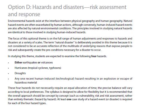
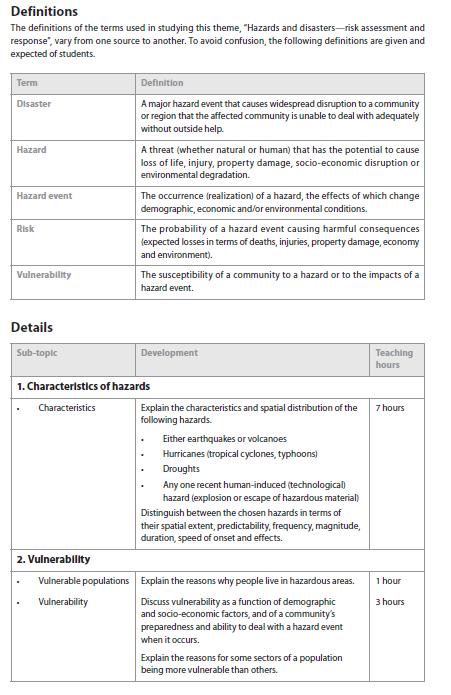
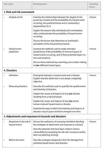
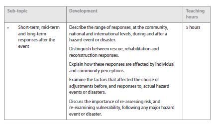
2 IB Geography The following topics will be covered over the two years. As indicated in the table, the Geographical Skills and Topographic Mapping will not be studied as separate topics, but will be incorporated throughout the course. The details of these topics are set out in the following pages. An outline of SL and HL assessment is shown on pages 10 & 11. Make sure that you refer to these syllabus details as we go through the course. There is a space for notes so that you can note when each piece of content has been covered in class. We will not necessarily go over everything in detail in class it will be up to you to cover some of the material at home. Before we begin the topics below, we will have a brief introduction to the geography course where we look at sources of information and ways of approaching these. HL/SL (incorporated throughout the program) HL/SL Topics HL Topics Geographical Skills (see attached list of subject specific skills chart) Patterns & Change Fresh water issues and conflicts Geography of Food & Health Hazards and Risk Assessment Global interactions 2
3 The IB learner profile The geography syllabus is closely linked to the IB learner profile, which strives to develop internationally minded people who recognize their common humanity and shared guardianship of the planet, and who help create a better and more peaceful world. By following the geography syllabus, students will have fulfilled the attributes of the IB learner profile. For example, the requirements of the internal assessment provide opportunities for students to develop every aspect of the profile. For each attribute of the learner profile, a number of examples selected from the skills and content of the geography syllabus are given below. Learner profile attribute Inquirers Geography syllabus Geographic skills: Collect and select relevant geographic information Knowledgeable Thinkers Communicators Content: Core theme, optional themes, HL extension Geographic skills: Research, process and interpret data and information; processing and interpreting Geographic skills: Produce written material (including essays, reports and investigations) Content: Make links to theory of knowledge Principled Open-minded Geographic skills: Research, process and interpret data and information; identify opinions, values and perceptions; make and justify decisions Geographic skills: Evaluate sources of geographic information in terms of reliability, bias, relevance and accuracy Caring Content: Core theme Risk-takers Geographic skills: Make and justify decisions Balanced Reflective Fieldwork: Collection of primary data and the subsequent treatment, display and analysis of the information Geographic skills: Evaluate methodology; develop clear and logical arguments and draw conclusions where appropriate 3
4 Geography Discipline Geography is a dynamic subject that is firmly grounded in the real world and focuses on the interactions between individuals, societies and the physical environment in both time and space. It seeks to identify trends and patterns in these interactions and examines the processes behind them. It also investigates the way that people adapt and respond to change and evaluates management strategies associated with such change. Geography describes and helps to explain the similarities and differences between spaces and places. These may be defined on a variety of scales and from a range of perspectives. Within group 3 subjects, geography is distinctive in that it occupies the middle ground between social sciences and natural sciences. The Diploma Programme geography course integrates both physical and human geography, and ensures that students acquire elements of both scientific and socio-economic methodologies. Geography takes advantage of its position between both these groups of subjects to examine relevant concepts and ideas from a wide variety of disciplines. This helps students develop an appreciation of, and a respect for, alternative approaches, viewpoints and ideas. Geography and the international dimension The geography course embodies global and international awareness in several distinct ways. It examines key global issues, such as poverty, sustainability and climate change. It considers examples and detailed case studies at a variety of scales, from local to regional, national and international. Throughout the course, teachers have considerable flexibility in their choice of examples and case studies to ensure that Diploma Programme geography is a highly appropriate way to meet the needs of all students, regardless of their precise geographical location. Inherent in the syllabus is a consideration of different perspectives, economic circumstances and social and cultural diversity. Geography seeks to develop international understanding and foster a concern for global issues as well as to raise students awareness of their own responsibility at a local level. Geography also aims to develop values and attitudes that will help students reach a degree of personal commitment in trying to resolve these issues, appreciating our shared responsibility as citizens of an increasingly interconnected world. Geography and theory of knowledge Students of group 3 subjects study individuals and societies. This means that they explore the interactions between humans and their environment in time and place. As a result, these subjects are often known collectively as the human sciences or social sciences. As with other subject areas, there is a variety of ways of gaining knowledge in group 3 subjects. For example, archival evidence, data collection, experimentation, observation, and inductive and deductive reasoning can all be used to help explain patterns of behaviour and lead to knowledge claims. Students in group 3 subjects are required to evaluate these knowledge claims by exploring knowledge issues such as validity, reliability, credibility, certainty and individual as well as cultural perspectives. The relationship between each subject and theory of knowledge is important and fundamental to the Diploma Programme. Having followed a course of study in group 3, students should be able to reflect critically on the various ways of knowing and methods used in human sciences. In doing so, they will become inquiring, knowledgeable and caring young people (IB mission statement). During the Diploma Programme geography course, a number of issues will arise that highlight the relationship between theory of knowledge and geography. Some of the questions that might be considered during the course are identified below. Are the findings of the natural sciences as reliable as those of the human sciences? What is the meaning of a scientific law in each area? To what extent do maps reflect reality? Do regions have boundaries? To what extent might it be true that geography combines the methods of human and natural sciences? Some geographical topics, such as climate change, are controversial. How does the scientific method attempt to address them? Are such topics always within the scope of the scientific method? What scientific or social factors might influence the study of a complex phenomenon such as global warming? Often in geography a model of reality is created. What does this mean? What are the advantages and disadvantages of creating a geographic model? In what areas of geography are models most common? 4
5 Arguably, while some aspects of geography can be measured, others cannot. Is this the case? What is it about a quality that means it cannot be quantified? If humans are individual and unique, does this mean that there can be no reliable laws in human geography? Many geographers and others value diversity in human affairs. Is globalization therefore a bad thing Group 3 aims The aims of all subjects in group 3, individuals and societies are to: 1. encourage the systematic and critical study of: human experience and behaviour; physical, economic and social environments; and the history and development of social and cultural institutions 2. develop in the student the capacity to identify, to analyse critically and to evaluate theories, concepts and arguments about the nature and activities of the individual and society 3. enable the student to collect, describe and analyse data used in studies of society, to test hypotheses, and to interpret complex data and source material 4. promote the appreciation of the way in which learning is relevant both to the culture in which the student lives, and the culture of other societies 5. develop an awareness in the student that human attitudes and beliefs are widely diverse and that the study of society requires an appreciation of such diversity 6. enable the student to recognize that the content and methodologies of the subjects in group 3 are contestable and that their study requires the toleration of uncertainty. Geography aims In addition, the aims of the geography syllabus at SL and HL are to enable students to: 7. develop an understanding of the interrelationships between people, places, spaces and the environment 8. develop a concern for human welfare and the quality of the environment, and an understanding of the need for planning and sustainable management 9. appreciate the relevance of geography in analysing contemporary issues and challenges, and develop a global perspective of diversity and change. There are four assessment objectives (AOs) for the SL and HL Diploma Programme geography course. Having followed the course at SL or HL, students will be expected to do the following. 1. Demonstrate knowledge and understanding of specified content Demonstrate knowledge and understanding of the core theme patterns and change Demonstrate knowledge and understanding of two optional themes at SL and three optional themes at HL At HL only, demonstrate knowledge and understanding of the HL extension global interactions In internal assessment, demonstrate knowledge and understanding of a specific geographic research topic 2. Demonstrate application and analysis of knowledge and understanding Apply and analyse geographic concepts and theories Identify and interpret geographic patterns and processes in unfamiliar information, data and cartographic material Demonstrate the extent to which theories and concepts are recognized and understood in particular contexts 3. Demonstrate synthesis and evaluation Examine and evaluate geographic concepts, theories and perceptions Use geographic concepts and examples to formulate and present an argument Evaluate materials using methodology appropriate for geographic fieldwork At HL only, demonstrate synthesis and evaluation of the higher level extension global interactions 4. Select, use and apply a variety of appropriate skills and techniques Select, use and apply the prescribed geographic skills in appropriate contexts Produce well-structured written material, using appropriate terminology Select, use and apply techniques and skills appropriate to a geographic research question 5
6 Command terms Classification of command terms Key command terms are used in the syllabus content under the development column, as described in the structure of the syllabus section, to indicate the depth of understanding that is required of students. These are classified below according to the assessment objectives of: Key command term Define Describe Determine Estimate Identify Outline State Analyse Classify Distinguish Explain Suggest Compare Compare and contrast Contrast Discuss Evaluate Examine Justify To what extent? Annotate Construct Draw Label Depth These terms require students to demonstrate knowledge and understanding. These terms require students to use and analyse knowledge and understanding. These terms require students to make a judgment based on evidence and when relevant construct an argument. These terms require students to demonstrate the selection and application of skills. Syllabus component /periods/weeks SL HL 6

7 Geographic skills integrated throughout the course Part 1: Core theme patterns and change (SL/HL) There are four compulsory topics in this core theme. 1. Populations in transition 2. Disparities in wealth and development 3. Patterns in environmental quality and sustainability 4. Patterns in resource consumption Part 2: Optional themes (SL/HL) Two optional themes are required at SL. Three optional themes are required at HL. A. Freshwater issues and conflicts F. Geography of Food and Health Part 2: Optional themes (HL) D. Hazards and disasters risk assessment and response 30 Part 3: HL extension global interactions (HL only) There are seven compulsory topics in the HL extension. 1. Measuring global interactions 2. Changing space the shrinking world 3. Economic interactions and flows 4. Environmental change 5. Sociocultural exchanges 6. Political outcomes 7. Global interactions at the local level Fieldwork (SL/HL) Fieldwork, leading to one written report based on a fieldwork question, information collection and analysis with evaluation Total teaching Geographic skills (SL/HL) These skills are essential to the study of geography and reflect the subject s distinctive methodology and approach. 7
8 these skills enriches the students understanding of geography and enables them to apply the techniques of geography and use appropriate terminology. It is essential that the skills are covered throughout the whole syllabus and that they are introduced and integrated where appropriate, depending on the context, in the different themes and the HL extension. It is essential that the skills are all taught at some stage of the course and are not treated in isolation. Students are expected to demonstrate competence in the use of geographic skills in examination papers and internal assessment as appropriate. Those skills indicated below in italics are not assessed in the externally assessed examination papers. It is recognized that the ability to use Geographic Information Systems (GIS) is a valuable geographic tool that goes beyond many of the skills listed below. Where GIS is accessible and practical, its use is encouraged. However, the syllabus does not require GIS and it will not be used in the assessment Skill Locate and differentiate elements of the Earth s surface Interpret, analyse and, when appropriate, construct tables, graphs, diagrams, cartographic material and images Undertake statistical calculations to show patterns and summarize information Using: direction latitude longitude Examples grid references and area references scale political units. All kinds of maps, including: isoline and isopleth maps choropleth maps topological maps dot maps flow maps thematic maps (including mental maps) topographic maps proportional symbols aerial photographs ground-level photographs satellite images graphs, including scatter, line, bar, compound, triangular, logarithmic, bipolar graphs pie charts flow diagrams/charts population pyramids Lorenz curves cross-profiles (sections) rose diagrams development diamonds. Such as: totals averages (means, medians, modes) frequencies ranges of data (differences between maximum and minimum) densities percentages 8
9 ratios. Research, process and interpret data and information Types of data and information: measures of correlation (including Spearman rank and Chi-square) measures of concentration and dispersion (including nearest neighbour and location quotients) measures of spatial interactions Collect and select relevant geographic information Evaluate sources of geographic information Produce written material (including essays, reports and investigations) Making: observations images Conducting: interviews Taking: measurements. In terms of accuracy relevance bias. Presenting: material in a clear and well-structured way Responding: appropriately to command terms. Command terms with definitions Students should be familiar with the following key terms and phrases used in examination questions, which are to be understood as described below. Although these terms will be used frequently in examination questions, other terms may be used to direct students to present an argument in a specific way. The assessment objectives (AOs) listed in the table are those referred to in the geography syllabus. Analyse - AO2 Break down in order to bring out the essential elements or structure. Annotate - AO4 Add brief notes to a diagram or graph. Classify - AO2 Arrange or order by class or category. 9
10 Compare - AO3 Give an account of the similarities between two (or more) items or situations, referring to both (all) of them throughout. Compare and contrast - AO3 Give an account of similarities and differences between two (or more) items or situations, referring to both (all) of them throughout. Construct - AO4 Display information in a diagrammatic or logical form. Contrast - AO3 Give an account of the differences between two (or more) items or situations, referring to both (all) of them throughout. Define - AO1 Give the precise meaning of a word, phrase, concept or physical quantity. Describe - AO1 Give a detailed account. Determine - AO1 Obtain the only possible answer. Discuss - AO3 Offer a considered and balanced review that includes a range of arguments, factors or hypotheses. Opinions or conclusions should be presented clearly and supported by appropriate evidence. Distinguish - AO2 Make clear the differences between two or more concepts or items. Draw - AO4 Represent by means of a labelled, accurate diagram or graph, using a pencil. A ruler (straight edge) should be used for straight lines. Diagrams should be drawn to scale. Graphs should have points correctly plotted (if appropriate) and joined in a straight line or smooth curve. Estimate - AO1 Obtain an approximate value. Evaluate - AO3 Make an appraisal by weighing up the strengths and limitations. Examine - AO3 Consider an argument or concept in a way that uncovers the assumptions and interrelationships of the issue. Explain - AO2 Give a detailed account including reasons or causes. Identify - AO1 Provide an answer from a number of possibilities. Justify - AO3 Give valid reasons or evidence to support an answer or conclusion. Label - AO4 Add labels to a diagram. Outline - AO1 Give a brief account or summary. State - AO1 Give a specific name, value or other brief answer without explanation or calculation. Suggest - AO2 Propose a solution, hypothesis or other possible answer. To what extent - AO3 Consider the merits or otherwise of an argument or concept. Opinions and conclusions should be presented clearly and supported with empirical evidence and sound argument. SL Assessment Assessment component Weighting External assessment (2 50 minutes) 75% Paper 1 (1 hour 30 minutes) Syllabus content: Core theme Assessment objectives % Section A: Students answer all short-answer questions. Some include data. (45 marks) Section B: Students answer one extended response question. (15 marks) 10
11 Section A and section B are common to both SL and HL assessment. (60 marks) Paper 2 (1 hour 20 minutes) Syllabus content: Two optional themes Assessment objectives 1 4 Students answer two structured questions based on stimulus material, each selected from a different optional theme. For each theme there is a choice of two questions. (20 marks per question) Some stimulus material is included in the resources booklet. This paper is common to both SL and HL assessment. (40 marks) Internal assessment (20 ) This component is internally assessed by the teacher and externally moderated by the IB at the end of the course. Syllabus content: Any topic from the syllabus Assessment objectives 1 4 Written report based on fieldwork. Maximum 2,500 words (30 marks) 35% 25% HL Assessment Assessment component Weighting External assessment (4 30 minutes) 80% Paper 1 (1 hour 30 minutes) Syllabus content: Core theme Assessment objectives % Section A: Students answer all short-answer questions. Some include data. (45 marks) Section B: Students answer one extended response question. (15 marks) 11
12 Section A and section B are common to both SL and HL assessment. (60 marks) Paper 2 (2 ) Syllabus content: Three optional themes Assessment objectives 1 4 Students answer three structured questions based on stimulus material, each selected from a different theme. For each theme there is a choice of two questions. (20 marks per question) Some stimulus material is included in the resources booklet. This paper is common to both SL and HL assessment. (60 marks) Paper 3 (1 hour) Syllabus content: Higher level extension Assessment objectives 1 4 Students answer one of three essay questions. (25 marks) Internal assessment (20 ) This component is internally assessed by the teacher and externally moderated by the IB at the end of the course. Syllabus content: Any topic from the syllabus Assessment objectives 1 4 Written report based on fieldwork. Maximum 2,500 words (30 marks) 35% 20% 20% 12
13 Syllabus SL/HL 13
14 Core: Patterns and change HL/SL The core theme provides an overview of the geographic foundation for the key global issues of our times. The purpose is to provide a broad factual and conceptual introduction to each topic and to the United Nations Millennium Goals (MDGs), in particular those concerning poverty reduction, gender equality, improvements in health and education and environmental sustainability. An evaluation of the progress made towards meeting these goals is also provided. The core theme also develops knowledge of the likely causes and impacts of global climate change, a major contemporary issue of immense international significance. An understanding of this issue is the fundamental basis for the section on Patterns in environmental quality and sustainability. The emphasis in teaching the core theme should be on the concepts underlying much of the content and the consequent regional and global patterns. Attention should be given to the positive aspects of change (not only the negative ones), to the need to accept responsibility for seeking solutions to the demographic, economic and environmental issues covered, and, where appropriate, to the management strategies adopted to successfully meet the challenges posed. It is recommended that as much of the content as possible is taught through appropriate examples and case studies, preferably chosen from a limited number of countries (between three and five) of contrasting levels of development. Although many of the ideas are reflected in differences at the local or sub-national scale, the emphasis in the core theme is on national, regional and global trends and patterns. It is not intended for the topics to be taught sequentially because some issues cover several of the topics. The approach to teaching is not prescribed and the content can be taught with flexibility according to the interests of the teacher and needs of the students. Definitions The definitions of the terms used in studying the core theme vary from one source to another. To avoid confusion, the following definitions are given and expected of students. Term Core and periphery Definition The concept of a developed core surrounded by an undeveloped periphery. The concept can be applied at various scales. Ecological footprint The theoretical measurement of the amount of land and water a population requires to produce the resources it consumes and to absorb its waste under prevailing technology. Global climate change The changes in global patterns of rainfall and temperature, sea level, habitats and the incidences of droughts, floods and storms, resulting from changes in the Earth s atmosphere, believed to be mainly caused by the enhanced greenhouse effect. GNI Gross national income (now used in preference to gross national product GNP). The total value of goods and services produced within a country together with the balance of income and payments from or to other countries. Migration The movement of people, involving a change of residence. It can be internal or external (international) and voluntary or forced. It does not include temporary circulations such as commuting or tourism. 14
15 Remittances Transfers of money/goods by foreign workers to their home countries. Soil degradation A severe reduction in the quality of soils. The term includes soil erosion, salinization and soil exhaustion (loss of fertility). Can be defined as: Water scarcity physical water scarcity, where water resource development is approaching or has exceeded unsustainable levels; it relates water availability to water demand and implies that arid areas are not necessarily water scarce economic water scarcity, where water is available locally but not accessible for human, institutional or financial capital reasons. 1. Populations in transition Sub-topic Population change Explain population trends and patterns in births (Crude Birth Rate), natural increase and mortality (Crude Death Rate, infant and child mortality rates), fertility and life expectancy in contrasting regions of the world. Analyse population pyramids. Explain population momentum and its impact on population projections. 5 Responses to high and low fertility Explain dependency and ageing ratios. Examine the impacts of youthful and ageing populations. Evaluate examples of a pro-natalist policy and an anti-natalist policy. 4 Movement responses migration Discuss the causes of migrations, both forced and voluntary. Evaluate internal (national) and international migrations in terms of their geographic (socio-economic, political and environmental) impacts at their origins and destinations. 6 Gender and change Examine gender inequalities in culture, status, education, birth ratios, health, employment, empowerment, life expectancy, family size, migration, legal rights and land tenure. 4 15
16 2. Disparities in wealth and development Sub-topic Measurements of regional and global disparities Define indices of infant mortality, education, nutrition, income, marginalization and human development index (HDI). Explain the value of the indices in measuring disparities across the globe. 3 Origin of disparities Explain disparities and inequities that occur within countries resulting from ethnicity, residence, parental education, income, employment (formal and informal) and land ownership. 3 Disparities and change Identify and explain the changing patterns and trends of regional and global disparities of life expectancy, education and income. Examine the progress made in meeting the Millennium Goals (MDGs) in poverty reduction, education and health. 5 Reducing disparities Discuss the different ways in which disparities can be reduced with an emphasis on trade and market access, debt relief, aid and remittances. Evaluate the effectiveness of strategies designed to reduce disparities. 5 16
17 3. Patterns in environmental quality and sustainability Sub-topic Atmosphere and change Describe the functioning of the atmospheric system in terms of the energy balance between solar and long wave radiation. Explain the changes in this balance due to external forcings (changes in solar radiation, changes in the albedo of the atmosphere and changes in the long wave radiation returned to space). Discuss the causes and environmental consequences of global climate change. 4 Soil and change Explain the causes of soil degradation. Discuss the environmental and socio-economic consequences of this process, together with management strategies. 4 Water and change Identify the ways in which water is utilized at the regional scale. Examine the environmental and human factors affecting patterns and trends in physical water scarcity and economic water scarcity. Examine the factors affecting access to safe drinking water. 5 Biodiversity and change Explain the concept and importance of biodiversity in tropical rainforests. Examine the causes and consequences of reduced biodiversity in this biome. 3 Sustainability and the environment Define the concept of environmental sustainability. Evaluate a management strategy at a local or national scale designed to achieve environmental sustainability. 3 17
18 4. Patterns in resource consumption Sub-topic Patterns of resource consumption Evaluate the ecological footprint as a measure of the relationship between population size and resource consumption. Identify international variations in its size. Discuss the two opposing views (neo-malthusian and anti-malthusian) of the relationship between population size and resource consumption. 4 Changing patterns of energy consumption Examine the global patterns and trends in the production and consumption of oil. Examine the geopolitical and environmental impacts of these changes in patterns and trends. Examine the changing importance of other energy sources. 2 6 Conservation strategies Discuss the reduction of resource consumption by conservation, waste reduction, recycling and substitution. Evaluate a strategy at a local or national scale aimed at reducing the consumption of one resource. 4 18
19 Option A: Freshwater issues and conflicts HL/SL This optional theme focuses on water on the land as a scarce resource. It considers the ways in which humans respond to the challenges of managing the quantity and quality of freshwater, as well as the consequences (whether intended or unintended, positive or negative) of management. The theme includes both the physical geography of freshwater (basic hydrology and floods) and human impacts on water quality. This theme should include the study of at least one detailed case study at the drainage basin level. Reference should be made to additional examples, at a range of scales, in less depth, wherever appropriate. Definitions The definitions of the terms used in studying this theme, Freshwater issues and conflicts, vary from one source to another. To avoid confusion, the following definitions are given and expected of students. Term Drainage basin Drainage divide Maximum sustainable yield Wetlands Definition The area drained by a river and its tributaries. Also known as a watershed, it is the line defining the boundary of a river or stream drainage basin separating it from adjacent basin(s). The maximum level of extraction of water that can be maintained indefinitely for a given area. Areas that are regularly saturated by surface water or groundwater, including freshwater marshes, swamps and bogs. 19
20 1. The water system Sub-topic The hydrological cycle The water balance Examine the inputs, outputs, stores and transfers of the hydrological cycle. Discuss the causes and consequences of the changing balance between water stored in oceans and ice. Explain the concept of maximum sustainable yield of freshwater in terms of a balance between inputs and outputs Drainage basins and flooding Sub-topic Drainage basins Examine the functioning of a drainage basin as an open system with inputs, outputs, transfers, stores and feedback loops. 2 Discharge Hydrographs Define stream discharge. Examine its relationship to stream flow and channel shape. Describe the characteristics of a hydrograph. Examine the reasons for spatial and temporal (short term and long term) variations in hydrographs. Examine the role of hydrographs in forecasting the magnitude, spatial extent and timing of floods. 1 hour 3 Floods Discuss the natural and human causes and consequences of a specific river flood. 3 20
21 Sub-topic Dams and reservoirs Floodplain management 3. Management issues and strategies Examine the hydrological changes resulting from the construction of dams and reservoirs. Examine the costs and benefits of dams and reservoirs as part of multi-purpose schemes. Explain the stream channel processes (erosion, transport, deposition) and explain the resultant landforms found on floodplains. Examine the human modifications of a floodplain and their effect on the size and probability of floods. Evaluate the costs and benefits of alternative stream management strategies. 2 3 Ground water management Explain the functioning and management of artesian basins and aquifers, distinguishing between natural and artificial recharge. Examine the environmental impacts of groundwater abstraction. 2 Freshwater wetland management Irrigation and agriculture Describe the role of wetlands as a water resource. Evaluate the effectiveness of the management strategies that have been adopted in a major wetland. Examine the environmental impact of agriculture and irrigation on water quality: salinization, agro-chemical runoff, the pollution of groundwater and the eutrophication of lakes, rivers and wetlands Competing demands for water Sub-topic Conflicts at the local or national scale Conflicts at the international scale Examine the competing demands for water in a specific river basin. Evaluate the strategies that have been adopted to meet these demands. Discuss an example of an international conflict related to freshwater. 6 21
22 Option F: The geography of food and health This optional theme is based on the underlying premise that the health of a population is the direct consequence of having enough food, a balanced diet and reduced susceptibility to disease. It covers a large area of knowledge, and time constraints mean that some parts may need to be covered in breadth rather than in depth. The topic on health serves as an introduction to the theme, with more detailed coverage required for the remaining two topics on food and disease. These latter sections relate to some of the United Nations Millennium Goals (MDGs), particularly those that challenge hunger and combat disease. Detailed case studies are recommended, especially when impacts and evaluations are required. Case studies of two diseases are required, chosen from two different categories out of the following three: vector borne, water borne or sexually transmitted disease. Definitions The definitions of the terms used in studying this theme, The geography of food and health, vary from one source to another. To avoid confusion, the following definitions are given and expected of students. Term Food miles Definition A measure of the distance that food travels from its source to the consumer. This can be given either in units of actual distance or of energy consumed during transport. HALE Transnational corporation (TNC) Health adjusted life expectancy, based on life expectancy at birth but including an adjustment for time spent in poor health (due to disease and/or injury). It is the equivalent number of years in full health that a newborn can A firm that owns or controls productive operations in more than one country through foreign direct investment. 22
23 1. Health Sub-topic Variations in health Describe the variations in health as reflected by changes in life expectancy at national and global scales since Explain the patterns and trends in terms of differences in income and lifestyle. Measuring health Evaluate life expectancy, infant mortality rate (IMR) and child mortality, HALE (health adjusted life expectancy), calorie intake, access to safe water and access to health services as indicators of health. 4 Prevention relative to treatment Discuss the geographic factors that determine the relative emphasis placed by policy makers, in one country or region, on prevention as opposed to treatment of disease. 2. Food Sub-topic Global availability of food Identify global patterns of calorie intake as one measure of food availability. Distinguish between malnutrition, temporary hunger, chronic hunger and famine. Discuss the concept of food security. 1 hour Areas of food sufficiency and deficiency Explain how changes in agricultural systems, scientific and technological innovations, the expansion of the area under agriculture and the growth of agribusiness have increased the availability of food in some areas, starting with the Green Revolution and continuing since. Examine the environmental, demographic, political, social and economic factors that have caused areas of food deficiency and food insecurity. 3 Sub-topic 23
24 Case study Production and Markets Examine the variety of causes responsible for a recent famine. Examine the impacts at a variety of scales of trade barriers, agricultural subsidies, bilateral and multilateral agreements, and transnational corporations (TNCs) on the production and availability of food. 4 3 Addressing imbalances Sustainable agriculture Evaluate the relative importance of food aid, free trade and fair trade in alleviating food shortages. Examine the concept of sustainable agriculture in terms of energy efficiency ratios and sustainable yields. Examine the concept of food miles as an indicator of environmental impact Disease Sub-topic Global patterns of disease Explain the global distribution of diseases of affluence. Explain the global distribution of diseases of poverty. 2 The spread of disease Explain how the geographic concepts of diffusion by relocation and by expansion apply to the spread of diseases. Examine the application of the concept of barriers in attempts to limit the spread of diseases. 4 Describe the factors that have enabled reduction in incidence of a disease. Geographic factors and impacts Examine the geographic factors responsible for the incidence and spread of two diseases. 4 Evaluate the geographic impact of these two diseases at the local, national and international scales. Evaluate the management strategies that have been applied in any one country or region for one of these diseases. 24
25 Syllabus HL 25
26 26
27 27
28 28
29 29
30 Global interactions HL Rationale and conceptual framework The study of global interactions in this syllabus has a broader perspective than a more conventional study of globalization that emphasizes a linear process involving the domination and the imposition of western culture on the world. In the context of this syllabus, global interaction suggests a two-way and complex process whereby cultural traits and commodities may be adopted, adapted or resisted by societies. The process is neither inevitable nor universal. The HL extension theme focuses on the global interactions, flows and exchanges arising from the disparities that exist between places. It presents important and contestable geographic issues of change in space and time for the HL student to question. This part of the syllabus is divided into seven topics relating to global interactions as outlined in the following table. Each topic has a conceptual base that is developed through the content. Topic 1. Measuring global interactions 2. Changing space the shrinking world 3. Economic interactions and flows 4. Environmental change 5. Sociocultural exchanges 6. Political outcomes 7. Global interactions at the local level Provides an introduction to the course by identifying the level and rate of global interactions. Identifies improved information and communications technology and transport as fundamental to all forms of global interaction. Purpose of the topic Topics 1 and 2 provide a basis for further study by examining the pattern(s) and process(es) of global interactions and the technology that has enabled them. Topics 3 6 identify the economic, environmental, sociocultural and political consequences of global interactions. They present an alternative perspective on these interactive processes and outcomes and question their inevitability. These topics recognize that the globalization process is not static but is still evolving. They examine the variation in its course and its speed and how it results in different levels of involvement and acceptance. Globalization may be resisted and rejected in some countries or sub-regions where local forces may reassert themselves as a reaction against the loss of distinctiveness and sovereignty. Topic 7 examines responses to the two-way global interactions operating at more local scales. Global interactions may encounter local obstacles and resistance, which modify them and result in hybridized outcomes. This topic involves local investigation. 30
31 Definitions The definitions of the terms used in studying the HL extension, Global interactions, vary from one source to another. To avoid confusion, the following definitions are given and expected of students. Term Civil society Core and periphery Cultural imperialism Food miles Globalization Globalization indices Definition Any organization or movement that works in the area between the household, the private sector and the state to negotiate matters of public concern. Civil societies include non-governmental organizations (NGOs), community groups, trade unions, academic institutions and faith-based organizations. The concept of a developed core surrounded by an undeveloped periphery. The concept can be applied at various scales. The practice of promoting the culture/language of one nation in another. It is usually the case that the former is a large, economically or militarily powerful nation and the latter is a smaller, less affluent one. A measure of the distance food travels from its source to the consumer. This can be given either in units of actual distance or of energy consumed during transport. The growing interdependence of countries worldwide through the increasing volume and variety of cross-border transactions in goods and services and of international capital flows, and through the more rapid and widespread diffusion of technology (source: IMF). The AT Kearney Foreign Policy index measures twelve variables, which are sub-divided into four baskets : economic integration, personal contact, technological connectivity and political engagement. Nations are ranked according to a calculated globalization index. The KOF index measures three main dimensions of globalization: economic, political and social, and nations are ranked accordingly. It is designed by the Swiss Federal Institute of Technology on a yearly basis. Glocalization GNI Outsourcing Time space convergence Transnational corporation (TNC) A term that was invented to emphasize that the globalization of a product is more likely to succeed when the product or service is adapted specifically to each locality or culture in which it is marketed. The increasing presence of McDonald s restaurants worldwide is an example of globalization, while changes made to the menus of the restaurant chain, in an attempt to appeal to local tastes, are an example of glocalization. Gross national income (now used in preference to gross national product GNP). The total value of goods and services produced within a country together with the balance of income and payments from or to other countries. The concept of taking internal company functions and paying an outside firm to handle them. Outsourcing is done to save money, improve quality or free company resources for other activities. The reduction in the time taken to travel between two places due to improvements in transportation or communication technology. A firm that owns or controls productive operations in more than one country through foreign direct investment. 31
32 1. Measuring global interactions Sub-topic Global participation Describe and evaluate one of the following two globalization indices: the AT Kearney index or the KOF index, as a measure of global interaction. Describe how the globalization index may be represented spatially. 4 Global core and periphery Discuss the spatial pattern of global interactions through the mapping of core areas at the focus of interaction (network hubs/nodes), the peripheries and areas relatively unaffected by these interactions. 2. Changing space the shrinking world Sub-topic Time space convergence and the reduction in the friction of distance Explain how a reduction in the friction of distance results in time space convergence. Examine the relative changes in the speed and capacity of two types of transport (air, ocean, road, rail, pipeline) responsible for the flow of goods, materials and people. Extension and density of networks Examine the changes in a transport, internet or telecommunications network in terms of the extension of links and nodes and the intensity of use at a national or global scale. 12 Describe the role of information and communications technology (ICT) in civil society and the transmission and flow of images, ideas, information and finance. Examine the contrasting rates, levels and patterns of adoption of an element of ICT in two countries. 32
33 3. Economic interactions and flows Sub-topic Financial flows Examine the importance of loans, debt repayment, development aid, remittances, foreign direct investment and repatriation of profits in the transfer of capital between the developed core areas and the peripheries. Examine the influence of governments, world trading organizations and financial institutions (such as the World Trade Organization, International Monetary Fund and World Bank) in the transfer of capital. 8 Labour flows Information flows Explain the causes and effects of one major flow of labour between two countries. Explain the role of ICT in the growth of international outsourcing. 33
34 4. Environmental change Sub-topic Degradation through raw material production Identify the effects of agro-industrialization and changes in international production and consumption on the physical environment. Discuss the environmental consequences of increasing international demand for one raw material. Examine the concept of food miles and the environmental consequences of increasing volumes of air freight. The effects of transnational manufacturing and services Discuss the reasons for and consequences of the relocation of polluting industries (such as some TNCs) and waste disposal (such as ICT, chemical and nuclear waste) to countries with weaker environmental controls and safety regulations. Describe one major pollution event affecting more than one country and examine the consequences of and responses to this event. 8 Transboundary pollution Examine the growth of environmental awareness as a consequence of these global interactions. Examine the role of one international civil society organization in fostering improved environmental management. Explain the evolution of uniform urban landscapes; the effects of common commercial activity, structures, styles of construction and infrastructure. Homogenization of landscapes 34
35 5. Sociocultural exchanges Sub-topic Cultural diffusion: the process Describe cultural traits in terms of language, customs, beliefs, dress, images, music, food and technology. Examine the diffusion of cultural traits resulting from the international movement of workers, tourists and commodities. Consumerism and culture Describe the role of TNCs and media in spreading consumer culture. Select two different branded commodities and examine the spatial and temporal pattern of adoption on a global scale. 8 Examine the role of diasporas in preserving culture in one country and the adoption of minority traits by host societies. Sociocultural integration Examine the impact of cultural diffusion on one indigenous and remote society through the influence of international interactions. Examine the ways in which international interactions may result in the homogenization and dilution of culture. Define and exemplify the concept of cultural imperialism. 35
36 6. Political outcomes Sub-topic Loss of sovereignty Discuss the links between the diminishing effectiveness of political borders and the flow of goods, capital, labour and ideas, and the role of one multi-governmental organization such as the European Union (EU), the Association of Southeast Asian Nations (ASEAN), the North American Free Trade Agreement (NAFTA) and MERCOSUR (the common market of South America). Discuss the shift of power from nation state to TNCs as a result of their economic size and dominance. Compare the wealth of TNCs with that of nation states. 10 Responses Examine the resurgence of nationalism in one country as it attempts to retain control of its resources and culture. Discuss anti-globalization movements. Discuss the attempts to control migration into one country. 36
37 7. Global interactions at the local level Sub-topic Defining glocalization Distinguish between the terms globalization and glocalization. Adoption of globalization Examine the extent to which commercial activities at a local scale have become globalized. Examine the reasons why the level and rate of adoption varies from place to place. Discuss civil society responses to globalization; the adoption, adaptation (glocalization) or rejection of globalized goods, services and cultural traits. Local responses to globalization Evaluate the relative costs and benefits of local commercial production to the producer, the consumer and the local economy, compared with the costs and benefits of globalized production. 10 Describe the role of civil societies in raising awareness of local and global environmental, social and cultural issues. Alternatives Examine the role of civil societies in supporting local economic activity and strengthening local cultural values. Discuss the position held by anti-globalization groups. Evaluate the quality of life of a contemporary non-globalized society. 37
Belfairs Academy GEOGRAPHY Fundamentals Map
 YEAR 12 Fundamentals Unit 1 Contemporary Urban Places Urbanisation Urbanisation and its importance in human affairs. Global patterns of urbanisation since 1945. Urbanisation, suburbanisation, counter-urbanisation,
Geographical knowledge and understanding scope and sequence: Foundation to Year 10
 Geographical knowledge and understanding scope and sequence: Foundation to Year 10 Foundation Year 1 Year 2 Year 3 Year 4 Year 5 Year 6 Year level focus People live in places Places have distinctive features
Topic 4: Changing cities
 Topic 4: Changing cities Overview of urban patterns and processes 4.1 Urbanisation is a global process a. Contrasting trends in urbanisation over the last 50 years in different parts of the world (developed,
Switching to AQA from Edexcel: Draft Geography AS and A-level (teaching from September 2016)
") Switching to AQA from Edexcel: Draft Geography AS and A-level (teaching from September 2016) If you are thinking of switching from OCR to AQA (from September 2016), this resource is an easy reference guide.
Switching to AQA from Edexcel: Draft Geography AS and A-level (teaching from September 2016) If you are thinking of switching from OCR to AQA (from September 2016), this resource is an easy reference guide.
GEOGRAPHY ADVANCED LEVEL
 GEOGRAPHY ADVANCED LEVEL The syllabus is based on the belief that geography makes a valuable contribution to education. This partly derives from the nature of the questions which geographers raise and
OIB GEOGRAPHY SYLLABUS. Theme
 OIB GEOGRAPHY SYLLABUS Summary of Themes Theme 1) Different views and interpretations of world organisation through the study of maps focusing on issues of globalisation and development; to include a critical
Year 9 plan Victorian Curriculum: Humanities Semester Two (Geography/Economics and Business)
") Year 9 plan Victorian Curriculum: Humanities Semester Two (Geography/Economics and Business) Implementation year: School name: Kyabram P-12 College Prepared By: Rowena Morris Identify Curriculum Curriculum
Year 9 plan Victorian Curriculum: Humanities Semester Two (Geography/Economics and Business) Implementation year: School name: Kyabram P-12 College Prepared By: Rowena Morris Identify Curriculum Curriculum
INDIANA ACADEMIC STANDARDS FOR SOCIAL STUDIES, WORLD GEOGRAPHY. PAGE(S) WHERE TAUGHT (If submission is not a book, cite appropriate location(s))
 WHERE TAUGHT (If submission is not a book, cite appropriate location(s))") Prentice Hall: The Cultural Landscape, An Introduction to Human Geography 2002 Indiana Academic Standards for Social Studies, World Geography (Grades 9-12) STANDARD 1: THE WORLD IN SPATIAL TERMS Students
Prentice Hall: The Cultural Landscape, An Introduction to Human Geography 2002 Indiana Academic Standards for Social Studies, World Geography (Grades 9-12) STANDARD 1: THE WORLD IN SPATIAL TERMS Students
Geography. Programme of study for key stage 3 and attainment target (This is an extract from The National Curriculum 2007)
") Geography Programme of study for key stage 3 and attainment target (This is an extract from The National Curriculum 2007) Crown copyright 2007 Qualifications and Curriculum Authority 2007 Curriculum aims
Geography Programme of study for key stage 3 and attainment target (This is an extract from The National Curriculum 2007) Crown copyright 2007 Qualifications and Curriculum Authority 2007 Curriculum aims
AP Human Geography Syllabus
 AP Human Geography Syllabus Textbook The Cultural Landscape: An Introduction to Human Geography. Rubenstein, James M. 10 th Edition. Upper Saddle River, N.J.: Prentice Hall 2010 Course Objectives This
Dublin City Schools Social Studies Graded Course of Study Grade 5 K-12 Social Studies Vision
 K-12 Social Studies Vision The Dublin City Schools K-12 Social Studies Education will provide many learning opportunities that will help students to: develop thinking as educated citizens who seek to understand
World Geography. WG.1.1 Explain Earth s grid system and be able to locate places using degrees of latitude and longitude.
 Standard 1: The World in Spatial Terms Students will use maps, globes, atlases, and grid-referenced technologies, such as remote sensing, Geographic Information Systems (GIS), and Global Positioning Systems
This table connects the content provided by Education Perfect to the NSW Syllabus.
 Education Perfect Geography provides teachers with a wide range of quality, engaging and innovative content to drive positive student learning outcomes. Designed by teachers and written by our in-house
OIB GEOGRAPHY SYLLABUS Revised for Theme
 OIB GEOGRAPHY SYLLABUS Revised for 2013 Summary of Themes Theme 1) Different views and interpretations of world organisation through the study of maps focusing on issues of globalisation and development;
LOUISIANA STUDENT STANDARDS FOR SOCIAL STUDIES THAT CORRELATE WITH A FIELD TRIP TO DESTREHAN PLANTATION KINDERGARTEN
 LOUISIANA STUDENT STANDARDS FOR SOCIAL STUDIES THAT CORRELATE WITH A FIELD TRIP TO DESTREHAN PLANTATION KINDERGARTEN Standard 2 Historical Thinking Skills Students distinguish between events, people, and
SUBJECT : Geography Topics: Learning Outcomes:
 SUBJECT : Geography 2016-17 Yr7 What is geography and Britain? Students are introduced to the topic of geography and why it is so important to our everyday lives. Within the subject students explore the
Geography. Geography A. Curriculum Planner and Skills Mapping Grid GCSE Version 1 October 2012
 Geography GCSE 2012 Geography A Curriculum Planner and Skills Mapping Grid Version 1 October 2012 www.ocr.org.uk/gcse2012 Year 10 Exam work Controlled Assessment Autumn 1 Autumn 2 Spring 1 Spring 2 Summer
Quarterly Pacing Guide 6th grade Social Studies Content Expectations
 6.G1 The World in Spacial Term Terms: Geographical Habits of Mind 6.G1.1 Spacial Thinking 6 - G1.1.1 Use maps, globes, and web based geography technology to investigate the world at global, interregional,
Enquiry question: How does the world s climate system function, why does it change and how can this be hazardous for people?
 Content Topic 1: Hazardous Earth Enquiry question: How does the world s climate system function, why does it change and how can this be hazardous for people? 1.1 The atmosphere operates as a global system
Geography General Course Year 12. Selected Unit 3 syllabus content for the. Externally set task 2019
 Geography General Course Year 12 Selected Unit 3 syllabus content for the Externally set task 2019 This document is an extract from the Geography General Course Year 12 syllabus, featuring all of the content
World Geography Review Syllabus
 Purpose Class: World Geography Review Syllabus This course is designed to help students review and remediate their understanding major themes, concepts, and facts connected to the study World Geography.
DEPARTMENT OF GEOGRAPHY B.A. PROGRAMME COURSE DESCRIPTION
 DEPARTMENT OF GEOGRAPHY B.A. PROGRAMME COURSE DESCRIPTION (3 Cr. Hrs) (2340100) Geography of Jordan (University Requirement) This Course pursues the following objectives: - The study the physical geographical
International Development
 International Development Discipline/Multi-discipline or trans-disciplinary field Tahmina Rashid Associate Professor, International Studies What is Development? a. Development as a state or condition-static
OCR 2008 AS and A level Geography Specification Mapping Guide
 OCR 2008 AS and A level Geography Specification Mapping Guide Contents Introduction Error! Bookmark not defined. Specification map: 2008 OCR AS and A level Geography 3 What's new? 10 Introduction This
M14/3/GEOGR/SP2/ENG/TZ0/XX/Q GEOGRAPHY STANDARD LEVEL PAPER 2. Monday 19 May 2014 (morning) 1 hour 20 minutes INSTRUCTIONS TO CANDIDATES
 1 hour 20 minutes INSTRUCTIONS TO CANDIDATES") M14/3/GEOGR/SP2/ENG/TZ0/XX/Q 22145203 GEOGRAPHY STANDARD LEVEL PAPER 2 Monday 19 May 2014 (morning) 1 hour 20 minutes INSTRUCTIONS TO CANDIDATES Do not open this examination paper until instructed to do
M14/3/GEOGR/SP2/ENG/TZ0/XX/Q 22145203 GEOGRAPHY STANDARD LEVEL PAPER 2 Monday 19 May 2014 (morning) 1 hour 20 minutes INSTRUCTIONS TO CANDIDATES Do not open this examination paper until instructed to do
ESSENTIAL CONCEPTS AND SKILL SETS OF THE IOWA CORE CURRICULUM
 ESSENTIAL CONCEPTS AND SKILL SETS OF THE IOWA CORE CURRICULUM SOCIAL STUDIES PROVIDED BY THE IOWA DEPARTMENT OF EDUCATION INTRODUCTION Social studies is the integrated study of the social sciences and
UNIVERSITY OF NAIROBI COLLEGE OF HUMANITIES AND SOCIAL SCIENCES FACULTY OF ARTS & SCHOOL OF PHYSICAL SCIENCES
 UNIVERSITY OF NAIROBI COLLEGE OF HUMANITIES AND SOCIAL SCIENCES FACULTY OF ARTS & SCHOOL OF PHYSICAL SCIENCES Department of Geography and Environmental Studies TEACHING MODULE CGP/SGP 321: ECONOMIC GEOGRAPHY
AQA A level Geography (2016) Mapping Guide
 Mapping Guide") AQA A level Geography (2016) Mapping Guide At a glance comparison of the AQA and Edexcel specifications...page 2 Support for teaching Edexcel AS and A level Geography...Page 3 What is the same?...page
AQA A level Geography (2016) Mapping Guide At a glance comparison of the AQA and Edexcel specifications...page 2 Support for teaching Edexcel AS and A level Geography...Page 3 What is the same?...page
GEOGRAPHY YEAR 11 ATAR 2019 COURSE OUTLINE
 GEOGRAPHY YEAR 11 ATAR 2019 COURSE OUTLINE Geography ATAR Year 11 Semester 1 Unit 1 Natural and ecological hazards 1 3 Geographical skills Mapping skills identify and interpret a variety of topographic
GRADE 6 SOCIAL STUDIES SOCIAL STUDIES APPLICATION. SOCIAL STUDIES STANDARDS for Grade 6
 GRADE 6 SOCIAL STUDIES The Archdiocese of Cincinnati has established the following Social Studies standards based on the most current teachings which are aligned to Ohio New Learning Social Studies Standards.
Wisconsin Academic Standards Science Grade: 8 - Adopted: 1998
 Main Criteria: Wisconsin Academic Standards Secondary Criteria: Subjects: Science, Social Studies Grade: 8 Correlation Options: Show Correlated Wisconsin Academic Standards Science Grade: 8 - Adopted:
a. Hunting and gathering SE/TE: 17, 19, 21, 22, 23, 25, 30 b. Tool making SE/TE: 17, 18, 19, 22, 23 c. Use of fire SE/TE: 17, 23, 30
 Ohio Academic Content Standards, Social Studies, Benchmarks and Indicators (Grade 6) Grade Six History Students use materials drawn from the diversity of human experience to analyze and interpret significant
HOLY CROSS CATHOLIC PRIMARY SCHOOL
 HOLY CROSS CATHOLIC PRIMARY SCHOOL Geography Policy Date Implemented Jan 17 Review Date Jan 22 Mission Statement Holy Cross Primary School is a Catholic School. We seek to provide a broad, balanced Christian
World Geography TEKS 2nd Nine Weeks. Unit of Study Regional Studies; U.S. and Canada Regional Studies; Latin America; and Europe
 World Geography TEKS 2nd Nine Weeks Unit of Study Regional Studies; U.S. and Canada Regional Studies; Latin America; and Europe 1) History. The student understands how geography and processes of spatial
Geography for Life. Course Overview
 Geography for Life Description In Geography for Life students will explore the world around them. Using the six essential elements established by the National Geographic Society students will be able to
Semester: Two. Study Hours: 28 contact/80 independent BSU Credits: 10 ECTS: 5
 BATH SPA UNIVERSITY Erasmus, exchange & study abroad module catalogue Geography: semester 2 Modules at Bath Spa University are usually worth either 10, 20 or 40 credits. If you are using the European Credit
Wisconsin Academic Standards Science Grade: 5 - Adopted: 1998
 Main Criteria: Wisconsin Academic Standards Secondary Criteria: Subjects: Science, Social Studies Grade: 5 Correlation Options: Show Correlated Wisconsin Academic Standards Science Grade: 5 - Adopted:
GEOGRAPHY. In relation to the above aims, candidates should, after completing this syllabus, be able to
 GEOGRAPHY AIMS The aims of this syllabus are to enable candidates 1. to recognize and understand the arrangement of phenomena and features on Earth as well as the inter-relationship and interaction among
Grade 5: Social Studies Practices
 Grade 5: Social Studies Practices A. Gathering and Using Evidence 1. Develop questions to help identify evidence about topics related to the historical events occurring in the Western Hemisphere that can
2015 Copyright Board of Studies, Teaching and Educational Standards NSW for and on behalf of the Crown in right of the State of New South Wales.
 2015 Copyright Board of Studies, Teaching and Educational Standards NSW for and on behalf of the Crown in right of the State of New South Wales. This document contains Material prepared by the Board of
Declaration Population and culture
 Declaration Population and culture The ministers of the parties to the Alpine Convention regard the socio-economic and socio-cultural aspects mentioned in Article 2, Paragraph 2, Item a., as being central
GRADE 5 SOCIAL STUDIES SOCIAL STUDIES APPLICATION. SOCIAL STUDIES STANDARDS for Grade 5
 GRADE 5 SOCIAL STUDIES The Archdiocese of Cincinnati has established the following Social Studies standards based on the most current teachings which are aligned to Ohio New Learning Social Studies Standards.
IA_Core Curriculum Social Studies (2010) High School
 High School") IA_Core Curriculum Social Studies (2010) High School Content Area 1 Behavioral sciences include, but are not limited to, the areas of sociology, anthropology and psychology. In addressing these disciplines
IA_Core Curriculum Social Studies (2010) High School Content Area 1 Behavioral sciences include, but are not limited to, the areas of sociology, anthropology and psychology. In addressing these disciplines
Chapter 2 - Lessons 1 & 2 Studying Geography, Economics
 Chapter 2 - Lessons 1 & 2 Studying Geography, Economics How does geography influence the way people live? Why do people trade? Why do people form governments? Lesson 1 - How Does Geography Influence the
World Geography Fall 2013 Semester Review Project
 Reporting Category RC 1: History, Government and Citizenship Standard WG.1 History. The student understands how geography and processes of spatial exchange (diffusion) influenced events in the past and
Paper Two - Optional Themes for Standard and Higher Level
 Paper Two - Optional Themes for Standard and Higher Level Timing: Approximately 40 minutes for each question (each is worth 20 marks). Choice: Higher Level candidates must answer three questions and Standard
Advanced Placement Human Geography
 Advanced Placement Human Geography I. Overview of the Course The purpose of the Advanced Placement (AP) Human Geography course is to introduce students to the systematic study of patterns and processes
Brazil The country of Brazil is used to consider the different climatic conditions that can occur and why that is. Sport
 SUBJECT : Geography 2014 15 Yr7 What is geography? Students are introduced to the topic of geography and why it is so important to our everyday lives. Within the subject students explore the differences
The Kenton County School District A System of Excellence Social Studies 4.1 Core Content for Assessment
 Big Idea: Government and Civics The study of government and civics allows students to understand the nature of government and the unique characteristics of American democracy, including its fundamental
@CrawshawGeog. A Level Geography. Crawshaw Academy
 @CrawshawGeog A Level Geography Crawshaw Academy Why study Geography? Students who choose geography will gain a deeper understanding of how the world works and how the people in it interact. Geography
M11/3/GEOGR/HP2/ENG/TZ0/XX/Q GEOGRAPHY HIGHER LEVEL PAPER 2. Friday 6 May 2011 (morning) 2 hours INSTRUCTIONS TO CANDIDATES
 2 hours INSTRUCTIONS TO CANDIDATES") M11/3/GEOGR/HP2/ENG/TZ0/XX/Q 22115202 GEOGRAPHY HIGHER LEVEL PAPER 2 Friday 6 May 2011 (morning) 2 hours INSTRUCTIONS TO CANDIDATES Do not open this examination paper until instructed to do so. Answer
M11/3/GEOGR/HP2/ENG/TZ0/XX/Q 22115202 GEOGRAPHY HIGHER LEVEL PAPER 2 Friday 6 May 2011 (morning) 2 hours INSTRUCTIONS TO CANDIDATES Do not open this examination paper until instructed to do so. Answer
Gedney Church End and Lutton St Nicholas Federated Primary Schools. Geography Policy
 Gedney Church End and Lutton St Nicholas Federated Primary Schools Geography Policy Contents: Introduction Expectations in Key Stage 1 Expectations in Key Stage 2 Aims Teaching and Learning Key Skills
St John s Catholic Primary School. Geography Policy. Mission Statement
 St John s Catholic Primary School Geography Policy Mission Statement We at St John s strive for excellence in education by providing a safe, secure and caring family environment where individuals are valued
Global Atmospheric Circulation. Past climate change and natural causes. Global climate change and human activity
 GCSE Geography Edexcel B Revision Checklist Paper 1. Global Geographical Issues Topic 1. Hazardous Earth Key Idea I know/ understand The world s climate system Global Atmospheric Circulation Past climate
Geography - Grade 8. Unit A - Global Settlement: Patterns and Sustainability
 Geography - Grade 8 Geographical Thinking: Spatial Significance Patterns and Trends Interrelationships Geographic Perspective Geographic Inquiry: STEP 1 - Formulate Questions STEP 2 - Gather and Organize
Amarillo ISD Social Studies Curriculum
 Amarillo Independent School District follows the Texas Essential Knowledge and Skills (TEKS). All of AISD curriculum and documents and resources are aligned to the TEKS. The State of Texas State Board
HPISD CURRICULUM (SOCIAL STUDIES, WORLD GEOGRAPHY)
") HPISD CURRICULUM (SOCIAL STUDIES, WORLD GEOGRAPHY) EST. NUMBER OF DAYS: 14 UNIT NAME Unit Overview UNIT 7 SOUTH WEST ASIA/NORTH AFRICA SWANA s geography has led to economic and cultural differences. Students
HPISD CURRICULUM (SOCIAL STUDIES, WORLD GEOGRAPHY) EST. NUMBER OF DAYS: 14 UNIT NAME Unit Overview UNIT 7 SOUTH WEST ASIA/NORTH AFRICA SWANA s geography has led to economic and cultural differences. Students
A.P. Human Geography
 A.P. Human Geography 2012-2013 Instructor: Chris Vitt Brief Description of Course AP Human Geography is designed to provide students with a learning experience equivalent to that obtained in most college
BIG IDEAS. Area of Learning: SOCIAL STUDIES Urban Studies Grade 12. Learning Standards. Curricular Competencies
 Area of Learning: SOCIAL STUDIES Urban Studies Grade 12 BIG IDEAS Urbanization is a critical force that shapes both human life and the planet. The historical development of cities has been shaped by geographic,
History and Social Science: Advanced Placement Human Geography
 History and Social Science: Advanced Placement Human Geography A.P. Human Geography Curriculum for Loudoun County Public Schools Ashburn, Virginia 2016 This curriculum document for Advanced Placement Human
GEOGRAPHY POLICY STATEMENT. The study of geography helps our pupils to make sense of the world around them.
 GEOGRAPHY POLICY STATEMENT We believe that the study of geography is concerned with people, place, space and the environment and explores the relationships between the earth and its peoples. The study
Curriculum Unit. Instructional Unit #1
 Curriculum Unit Name of Course: AP Human Geography Grade Level(s): 9-12 Brief Description (Course Catalog): The purpose of the AP Human Geography course is to introduce students to the systematic study
STAG LANE JUNIOR SCHOOL GEOGRAPHY POLICY
 Status-Recommended Prepared by: Megha Visavadia Date written January 2017 Shared with staff: Spring 2017 STAG LANE JUNIOR SCHOOL GEOGRAPHY POLICY Shared with governors: Spring 2018 Date for review: July
GGY 301: Research Methods
 GGY 301: Research Methods Course No GGY 301 Course Title Research Methods Core/Optional Core for Special Degree :This course provides students with a basic knowledge and understanding of the research methodology
GRADE 8 LEAP SOCIAL STUDIES ASSESSMENT STRUCTURE. Grade 8 Social Studies Assessment Structure
 Grade 8 Social Studies Assessment Structure 1 In 2013-2014, the grade 8 LEAP test continues to assess Louisiana s social studies benchmarks. The design of the multiple-choice sessions of the test remains
Curriculum and Assessment in Geography at KS3
 Curriculum and Assessment in Geography at KS3 Curriculum Statement: Geography The world as we know it is not given and it can and it will change. - Lambert et al. Powerful Knowledge in Geography Geography
World Geography Unit Curriculum Document
 Unit Number and Title: Unit 9-Review (including a comparison to North America) Curriculum Concepts: Globalization Culture Democracy Diversity Migration Enduring Understandings (Big Ideas): Time Frame:
BELRIDGE SECONDARY COLLEGE GEOGRAPHY. Natural & Ecological Hazards. Global Networks & Interconnections NAME:
 BELRIDGE SECONDARY COLLEGE GEOGRAPHY Natural & Ecological Hazards Global Networks & Interconnections NAME: BELRIDGE SECONDARY COLLEGE YEAR GEOGRAPHY 205 The study of geography draws on students curiosity
Pikes Lane Primary School. Geography Statement of Practice
 Pikes Lane Primary School Geography Statement of Practice Subject Leader: Mrs Cawley Subject Link Governor: Mr Scholar & Mrs Azad Last Updated: September 2016 Review Date: September 2017 Aims and objectives
3. What is the etymology (how the word came to be) of geography. 4. How does the study of physical geography differ from that of human geography?
 of geography. 4. How does the study of physical geography differ from that of human geography?") AP Human Geography Unit 1: Basic Concepts and Development Guided Reading Mr. Stepek Directions: Follow the common directions distributed to you for guided reading assignments. Rubenstein p 2 5 (Introduction)
AP Human Geography Unit 1: Basic Concepts and Development Guided Reading Mr. Stepek Directions: Follow the common directions distributed to you for guided reading assignments. Rubenstein p 2 5 (Introduction)
AP HUG REVIEW WELCOME TO 2 ND SEMESTER! Annette Parkhurst, M.Ed. January, 2015
 AP HUG REVIEW WELCOME TO 2 ND SEMESTER! Annette Parkhurst, M.Ed. January, 2015 Movement Globalization Latitude & Elevation Levels of Economic Activities CONNECTIONS Human Geography Human is the geography
I CAN STATEMENTS 6TH GRADE SOCIAL STUDIES
 6TH GRADE SOCIAL STUDIES I can compare historical issues involving rights, roles and statues of individuals. I can describe the relationships among specialization, division of labor, productivity of workers
Course Introduction II
 CULTURE GEOG 247 Cultural Geography Course Introduction II Prof. Anthony Grande Hunter College-CUNY AFG 2015 Culture is the essence of human geography because it influences all aspects of life on earth.
SOCIAL SCIENCES. WORLD GEOGRAPHY LH Grade(s): 9 Pre-Req: N/A
: 9 Pre-Req: N/A") SOCIAL SCIENCES WORLD GEOGRAPHY 21033000 Grade(s): 9 The World Cultural Geography course consists of the following content area strands: American History, World History, Geography, Humanities, Civics and
SOCIAL SCIENCES WORLD GEOGRAPHY 21033000 Grade(s): 9 The World Cultural Geography course consists of the following content area strands: American History, World History, Geography, Humanities, Civics and
Geography Policy. Introduction
 Geography Policy Introduction Geography at St. Aloysius Federation School teaches an understanding of places and environments and aims to inspire a curiosity and fascination about the world and its people.
POLITICAL SYSTEMS. (ps ) Evaluate positions taken regarding the necessity of government and the purposes of government.
 Evaluate positions taken regarding the necessity of government and the purposes of government.") Baltimore City Public School System Social Studies Content Standards (Grade 8) POLITICAL SYSTEMS In the context of U.S. History through 1877, at the end of grade 8, students know and are able to do everything
Baltimore City Public School System Social Studies Content Standards (Grade 8) POLITICAL SYSTEMS In the context of U.S. History through 1877, at the end of grade 8, students know and are able to do everything
Seventh Grade Social Studies Curriculum Map
 Semester Unit Unit Focus NC Essential Standards Social Studies Literacy in History/ Social Studies 1 1st Unit 1 Intro to Geography Culture Explorers Constitution Day Terrorism (9-11) 1st Unit 2 Renaissance
Eastern Hemisphere Geography 7th Grade *Chapters 1-10 covered in 6 th Grade
 Quarter 1 Geography Tools and Concepts Chapters 1-5 Intro to Geography = 2 day review Goal Objective Task Analysis Vocabulary Text Location Goal 2.1: Analyze the 6-9.GEH.2.1.1 Explain and use the Identify
The Purpose of the Charter on Geographical Education
 2016 International Charter on Geographical Education Contents Purpose of the Charter on Geographical Education... 1 The Contribution of Geography to Education 3 Research in Geographical Education... 3
Pacemaker World Geography and Cultures. correlated to. Louisiana Social Studies Grade Level Expectations: World Geography Geography Grades 9-12
 Pacemaker World and Cultures correlated to Louisiana Social Studies Grade Level Expectations: World Grades 9-12 Pacemaker World and Cultures Pearson Learning Group correlated to Louisiana Social Studies
Minnesota K-12 Academic Standards in Social Studies. Grade 4: Geography of North America
 Minnesota K-12 Academic s in Social Studies Grade 4: Geography of North America 4 Describe how people take 1. Democratic government action to influence a depends on informed and decision on a specific
Seymour Centre 2017 Education Program 2071 CURRICULUM LINKS
 Suitable for: Stage 5 Stage 6 HSC Subject Links: Seymour Centre 2017 Education Program 2071 CURRICULUM LINKS Science Stage Content Objective Outcomes Stage 5 Earth and Space ES3: People use scientific
Fourth Grade Social Studies Crosswalk
 Fourth Grade Social Studies Crosswalk This crosswalk document compares the 2010 K-12 Social Studies Essential Standards and the 2006 North Carolina Social Studies Standard Course of Study (SCOS) and provides
Give 4 advantages of using ICT in the collection of data. Give. Give 4 disadvantages in the use of ICT in the collection of data
 Give 4 advantages of using ICT in the collection of data can use a handheld GPS to get accurate location information which can be used to show data linked to specific locations within a GIS can collect
4th Grade Social Studies GLEs
 4th Grade Social Studies GLEs Geography The World in Spatial Terms 1. Interpret different kinds of maps using a map key/legend, compass rose, cardinal and intermediate directions, and distance scale (G-1A-E1)
People and Society 3 days
 GCSE Geography OCR B People and Society 3 days In-depth coverage of fieldwork within a human environment, enabling students to get the grades they want within section B of the paper 2 exam: Human Geography
Geography Exams. RAG rate The Challenge of Natural Hazards
 Geography Exams You will sit three papers, Paper 1 will last 1 hour 30 minutes and will examine your understanding of The Challenge of Natural Hazards, The Living World and Physical Landscapes in the UK.
Nature s Art Village
 Nature s Art Village Educational Field Trip Programs Guide To: College, Career & Civic Life C3 Framework For Social Studies State Standards Grades 3 through 5 All That Glitters Children journey back in
2002 HSC Notes from the Marking Centre Geography
 2002 HSC Notes from the Marking Centre Geography 2003 Copyright Board of Studies NSW for and on behalf of the Crown in right of the State of New South Wales. This document contains Material prepared by
Unit 6: Development and Industrialization. Day 1: What is development?
 Unit 6: Development and Industrialization Day 1: What is development? What is Development? The process of improving the material conditions of people through the diffusion of knowledge and technology More
Alaska Content and Performance Standards Science Grade: 7 - Adopted: Concepts of Life Science (SC1, SC2, SC3)
") Main Criteria: Alaska Content and Performance Standards Secondary Criteria: Subjects: Science, Social Studies Grade: 7 Correlation Options: Show Correlated AK.C1. Alaska Content and Performance Standards
Main Criteria: Alaska Content and Performance Standards Secondary Criteria: Subjects: Science, Social Studies Grade: 7 Correlation Options: Show Correlated AK.C1. Alaska Content and Performance Standards
ILLINOIS CERTIFICATION TESTING SYSTEM
 ILLINOIS CERTIFICATION TESTING SYSTEM FIELD 113 SOCIAL SCIENCE: GEOGRAPHY November 2003 Illinois Certification Testing System FIELD 113 SOCIAL SCIENCE: GEOGRAPHY November 2003 Subarea Range of Objectives
Unit 1 Welcome to the World
 Unit Welcome to the World There are five fields of learning in social studies. We learn about the world and its people by studying geography, history, economics, government, and culture. A Mongolian yurt,
Challenges of Urbanisation & Globalisation
 Challenges of Urbanisation & Globalisation Prepared by: Khairul Hisyam Kamarudin, PhD Feb 2016 Based on original lecture note by: Wan Nurul Mardiah Wan Mohd Rani, PhD URBANIZATION What is Urbanization?
Arizona Educator Proficiency Assessments (AEPA ) FIELD 04: GEOGRAPHY TEST OBJECTIVES
 FIELD 04: GEOGRAPHY TEST OBJECTIVES") Arizona Educator Proficiency Assessments (AEPA ) TEST OBJECTIVES Subarea Range of Objectives Approximate Test Proportions I. Geographic Concepts and Skills 1 6 25% II. World Geography 7 14 34% III. United
Arizona Educator Proficiency Assessments (AEPA ) TEST OBJECTIVES Subarea Range of Objectives Approximate Test Proportions I. Geographic Concepts and Skills 1 6 25% II. World Geography 7 14 34% III. United
Social Studies Curriculum Sixth Grade
 Social Studies Curriculum Sixth Grade A. History Students will examine the key historic movements, events, and figures that contributed to the development of modern Europe and American nations from early
WORLD GEOGRAPHY INSTRUCTIONAL PACING GUIDE
 FIRST NINE WEEKS Standard USHC-1 Standard WG-1: The student will demonstrate an understanding of the physical and human characteristics of places, including the creation of regions and the ways that culture
The National Spatial Strategy
 Purpose of this Consultation Paper This paper seeks the views of a wide range of bodies, interests and members of the public on the issues which the National Spatial Strategy should address. These views
INTERNATIONAL CULTURAL TOURISM CHARTER Managing Tourism at Places of Heritage Significance (1999)
") INTERNATIONAL CULTURAL TOURISM CHARTER Managing Tourism at Places of Heritage Significance (1999) Adopted by ICOMOS at the 12th General Assembly in Mexico, October 1999. INTRODUCTION The Charter Ethos
INTERNATIONAL CULTURAL TOURISM CHARTER Managing Tourism at Places of Heritage Significance (1999) Adopted by ICOMOS at the 12th General Assembly in Mexico, October 1999. INTRODUCTION The Charter Ethos
Geography Policy 2014
 Geography Policy 2014 DEFINITION Geography education should inspire in pupils a curiosity and fascination about the world and its people that will remain with them for the rest of their lives. Teaching