Landform Project. Due Date: March 30, This is worth SS., Science, and LA grades!
|
|
|
- Jasmine Wilson
- 6 years ago
- Views:
Transcription
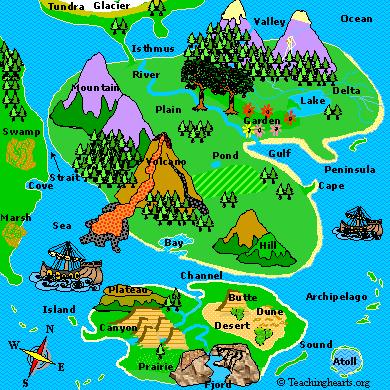
1 Landform Project Due Date: March 30, This is worth SS., Science, and LA grades! Create a map and a diorama in a pizza box to demonstrate landform meanings. Show and label landforms on both the map and the diorama using artistic and creative design. The diorama can be made from paper, clay, or salt dough. Basic Project Requirements: (Any additional will add to grade!) Create a landform diorama with the basic features in the bottom of a pizza box. (Add other features for extra credit.) Create a map of your diorama including a map key and compass rose. Attach the map to the lid of the box. ADD 2 of your choosing to make a total of 10 landforms! Mountain /Volcano Sea Desert Plain Lake Island Valley River Materials Suggested: Flour Salt Paint Paint brushes Tooth picks Sand Rocks Paint: Buy the correct color paint or use food coloring in the dough. Blue, for rivers and sea Brown, for top of mountains Green, for land White, if you want snow capped mountains Red for lava. Also use red seed beads or red glitter glue.

2 Other Supplies: Pizza box, or box of similar size. Cardboard base, slightly smaller than the bottom of the box. Paper cup to mix sand and glue. Salt Dough Recipe 2 cups white flour 1 cup salt 1 cup boiling water 3 teaspoons of vegetable oil Mix flour and salt Add boiling water and oil. Stir with a spoon. Knead when it is cool. Store unused dough in a sealed plastic bag in the refrigerator. Let it warm to room temperature before using it. Take only what you need and leave it in a sealed container when you are making your project. There are several types of landforms located around the world. Landforms are included in ecosystems such as the rainforest, tundra, desert, forest, grasslands, and oceans. Each ecosystem has landforms with unique characteristics. Choose landforms that naturally occur in your chosen ecosystem. For instance, prairie landforms would not be found in a rainforest! Remember to make a map key!
3 Use plastic toys and dolls to add interest to your landform diorama! Assemble: Dough. Mix the dough. Two cups of flour will be enough to make three mountains and the plains for a 12 x 12 landscape (30 x 30 cm). Draw Map. Draw a rough map the same size as the base of your box. Copy this map on the cardboard that will be used for the base. It will be used to guide you in painting and placing your features. Do not create your project in the box. Decide where "North" is located. Next, decide where to put these features in this order: Mountain, sea, desert, plain, lake and Island. The valley is between the mountains. Draw a curving river from the mountain, through the valley and down to the plain and into the sea. Mountains. Mountains should not be taller than 6 inches (15 cm). For mountains higher than two inches (five cm), make a cone by folding a piece of cardboard. Staple and tape it. Stuff with paper. Make sure that it can stand upright. Roll a piece of dough flat and cover the outside. Place it on the base and arrange all the mountains together. Then fill in the spaces between with dough until you have shaped your mountain. Volcano. Make sure that there is a depression in the top. You can even place a straw or tube in the center for a central vein. Valley. The valley is automatically formed between two mountains. Fill up the space between the mountains from the base at least an inch (2½ cm) Plains. Fill in the spaces between the mountains and the valley, following a gentle slope down to the sea. Use small pieces of dough and press them in or spread them with your fingers. Use the boundary lines of the map to know where to place the dough. Do not cover the sea, lakes, ponds or the desert with the dough. River. Draw the main river in the soft dough. The tributaries can be painted following the natural curved lines created when you made the plains. Labels, Trees and Accessories. While the dough is soft, use a toothpick to poke deep holes into all the places where trees or labels will be placed. Accessories. If you have miniature items like animals, put them in the soft dough so that they will make a permanent mark where they will be placed. Remove them and leave the holes to dry. Let it dry over night. If you allow the dough to dry before making all your holes, then add more soft dough and paint. Insert your trees or other items and allow to dry. This reshapes your landscape, so be careful. Green. Paint all of the dough green for land forms. Do not worry about going over the edges. Let it dry. Dab light green paint on the dark green to simulate grass. Brown. Paint the tops of the mountains brown or white. Blue. Paint the sea and lake on the cardboard or glue blue paper. Paint the rivers or use blue glitter glue. Coast Line and Beaches. The sand will be used to hide the imperfections in your painting between the water and the land.
4 Mix glue and sand. Pour on the edges. You can add sand over this to give a more natural look. Use a stiff brush to sweep away the excess sand. Use tiny brush strokes to remove sand. Desert. Glue sand to the bottom. Pour loose sand on top to get a more realistic effect. Volcano. Use red glitter glue or, mix sand, glue and red paint. Squeeze out of a tube or pour on the top and let it slowly run down. Pour it only on one side if you want the lava to flow only from one side. Stretch out a cotton ball so that it is thin. You can use it to simulate smoke coming from the mountain. Glue to the top or to a tooth pick so that it rises a little above the top. Map. Use the rough map to draw your finished map. Your map should have the following: 1. Color with construction paper or colored printer paper. 2. Map key 3. Compass Labels. Make labels. Cut along the solid lines. Fold the label in half at the dotted lines and glue a toothpick behind the dotted line. This creates a label that can be read from both sides. Accessories. Place your miniature items in the locations that you have created for them. Box. 1. Cover or paint the box so that it looks attractive. 2. Attach the map to the lid of the box with a glue stick. 3. Attach the labels with your name and the name of the landform. 4. Insert your three dimensional landform. 5. Add the labels for your features and any miniature accessories. Suggested Landforms: Note- These vocabulary words will be on an end-of-unit matching test! Students should study all meanings! Continent. A large continuous land mass. Island. A piece of land surrounded by water. Desert. A hot, very dry, treeless area that is usually filled with sand. Tundra. A cold treeless area. Forest. A large area of land with many trees. Garden. A formal and artistic arrangement of interesting plants and flowers. Archipelago. A group or chain of islands. Atoll. A ring of coral that forms an island. Plain. A large, flat area of land in the low lands with mostly no trees and minor changes in elevation. Prairie. A wide, flat area that has grass and a few trees. (See plain) Crater. A large depression in the earth caused by the impact of an asteroid or other object from space. Isthmus. A narrow strip of land that connects two land masses and has water on each side. (See strait) Coast. The boundary between the land and the sea. Beach. A wide, flat area of sand that covers the coast.
5 Delta. A low watery land at the mouth of a river. It is usually shaped like a triangle. Wet land. An area of land that is often wet. (e.g. swamp, bog, marsh, moor ) Cape. A pointed piece of land that sticks out into a body of water. (See peninsula). Peninsula. A large body of land that is surrounded by water on three sides. (See cape). Mountains and High Lands Mountain. A land that is raised above the surrounding area. It is over 2000 feet (610 m) high. Volcano. A cone shaped mountain or hill built around a vent that connects it with reservoirs of melted rock below the surface of the earth. Hill. A landform that is raised above the surrounding area, but is smaller than a mountain. Plateau. A flat open country in the high lands. Dune. Temporary hills of sand shaped by the wind. Cliff. A vertical rock exposure. Butte. A rock or hill formation with a flat top and steep sides. (See mesa) Mesa. A land formation with a flat top and steep sides in a dry area. Valley. The low areas between two elevations. Canyon. A deep valley between high cliffs or formations with steep sides. Water Ocean. A large body of salt water that surrounds a continent. Sea. A large body of salt water that may be partly or totally surrounded by land. Lake. A large body of water surrounded by land. Pond. A small body of water surrounded by land. River. A large, flowing body of water that empties into the sea. Tributary. A stream or river that flows into a larger river. Glacier. A slow moving river of ice. Lagoon. A shallow body of water along a coast. Gulf. A part of the ocean or sea that is partly surrounded by land. Bay. A small body of water that is partially enclosed by land. Fjord. A long narrow sea inlet that is bordered by steep cliffs. (See canyon). Sound. A wide sea inlet that is parallel to the coast. It is usually between the coast and an island. (See fjord). Channel. A deep and wide strip of water that separates two larger bodies of water. It is usually part of a river. (See strait). Cove. A small, horseshoe shaped body of water on a coast. Strait. A narrow body of water that connects two larger bodies of water. It has land on both sides. (See isthmus) Swamp. Fresh water wet land with very muddy, spongy land. Marsh. Salt water or fresh water wet land that is found beside rivers, lakes and coasts. Source. The beginning of a river. Map Example
6
7 Landforms Project Grading Rubric Student name: Island name: Project passed in on: *Projects that are passed in after the March 30, 2015 due date will be lowered by one letter grade.* CATEGORY points points points 0-9 points Landforms Present Map Key Spelling and Capitalization 10 landforms are labeled on the map. Position of landforms is logical. All landforms are label and coordinate with key. 100% of words on the map are spelled and capitalized correctly. 9-7 landforms are labeled on the map 9-7 landforms coordinate with key. Most of the words on the map are spelled and capitalized correctly. 6-4 landforms are labeled on the map. 6-4 landforms coordinate with key More than 50% of the words on the maps are spelled/and or capitalized correctly. Less than 4 landforms are labeled on the map. No key or very few landforms. Less than 50% of the words on the map are spelled and/or capitalized correctly. Map Title and compass rose Neatness of Project Title tells the content of the map, is clearly distinguishable as the title (larger letters or underlined), and is printed at the top of the map. Compass rose is neat, present, and is labeled. All errors have been neatly corrected and all features are colored completely. Title tells the content of the map and is printed at the top of the map. Compass rose is present but not neat. Most errors have been neatly corrected and most features are colored completely. Title tells the content of the map, but is not located at the top of the map. Compass rose is not neat or labeled Many errors have been neatly corrected and most features are colored completely. Content of the map is not clear from the title. No compass rose present. Lines, corrections of errors, and/or features are not neatly done. Rubric total:
UNIT 2 WARM UP. List the OCEANS. Bonus: Name the Largest LAKE on Earth
 UNIT 2 WARM UP List the OCEANS Bonus: Name the Largest LAKE on Earth Land Forms Land Mountain Hill Cliff Butte Mesa Plateau Cave Volcano Desert Plains Prairie Steppe Marsh Swamp Tundra Glacier Continent
What is a landform? These shapes (except for bodies of water) on the earth s surface are all examples of landforms.
 on the earth s surface are all examples of landforms.") Landforms What is a landform? These shapes (except for bodies of water) on the earth s surface are all examples of landforms. archipelago a large group of many islands. The Hawaiian Islands Lighthouse
Landforms What is a landform? These shapes (except for bodies of water) on the earth s surface are all examples of landforms. archipelago a large group of many islands. The Hawaiian Islands Lighthouse
Unit 1: Geography GeoTrekkers in the Western Hemisphere. Illustrated Glossary
 Unit 1: Geography GeoTrekkers in the Western Hemisphere Illustrated Glossary adapt to change in order to fit new condi/ons archipelago a group or chain of islands clustered together in a sea or ocean bodies
44H1749S SCIENCE ACTIVITY HEADS IN, HEARTS IN. Creating Landforms. Instructions for Set-Up. Activity Preparation
 HEADS IN, HEARTS IN Creating Landforms Instructions for Set-Up Supplies Guide for Families handout 15 clear plastic standup displays (optional) Landforms handouts 13 disposable cookie sheets, 9-inch by
Developed in Consultation with Florida Educators
 Developed in Consultation with Florida Educators Table of Contents Next Generation Sunshine State Standards Correlation Chart... 7 Benchmarks Chapter 1 The Practice of Science...................... 11
ORLD G EOGRAPHY BASIC. NotB oring. Inventive Exercises to Sharpen Skills and Raise Achievement. Imogene Forte & Marjorie Frank
 The BASIC NotB oring SERIES SOCIAL IP 402-0 STUDIES SKILLS MIDDLE GRADES ORLD G EOGRAPHY Inventive Exercises to Sharpen Skills and Raise Achievement Series Concept & Development by Imogene Forte & Marjorie
Grade 5 Hands on Science Weathering, Erosion and Deposition
 Grade 5 Hands on Science Weathering, Erosion and Deposition Objective: To demonstrate and investigate the effect of weathering, water and wind erosion and the subsequent deposition into landforms. Background:
netw rks Guided Reading Activity Essential Question: How does geography influence the way people live? Earth's Physical Geography
 Guided Reading Activity Lesson 1 Earth and the Sun Essential Question: How does geography influence the way people live? Looking at Earth Directions: What are the layers that make up Earth? Use your textbook
LANDFORMS. Extra Credit. Name Date
 LANDFORMS Extra Credit Name Date 1. Label the drawing above using the words below that match the landforms. canyon meander plateau delta mountain valley 2. The bending of rock at plate boundaries is A.
Changes to Land 5.7B. landforms: features on the surface of Earth such as mountains, hills, dunes, oceans and rivers
 All the landforms on Earth have changed over time and continue to change. Many of the changes were caused by wind, moving water, and moving ice. Mountains have grown and shrunk. Rivers have cut away land
Think about the landforms where you live. How do you think they have changed over time? How do you think they will change in the future?
 reflect All the landforms on Earth have changed over time and continue to change. Many of the changes were caused by wind, moving water, and moving ice. Mountains have grown and shrunk. Rivers have cut
(version 3) I. HumAN -Environment Interaction
 I. HumAN -Environment Interaction") (version 3) I. HumAN -Environment Interaction A. Landforms 1. Earth s topography is made up of many different types of landforms. 2. While the planet is covered primarily with water, the four major types
(version 3) I. HumAN -Environment Interaction A. Landforms 1. Earth s topography is made up of many different types of landforms. 2. While the planet is covered primarily with water, the four major types
EROSION RATES (1 Hour)
") EROSION RATES (1 Hour) Addresses NGSS Level of Difficulty: 2 Grade Range: 3-5 OVERVIEW In this activity, students will conduct simple investigations to collect data on erosion rates of different Earth
EROSION RATES (1 Hour) Addresses NGSS Level of Difficulty: 2 Grade Range: 3-5 OVERVIEW In this activity, students will conduct simple investigations to collect data on erosion rates of different Earth
Wednesday, November 15, 2017
 Wednesday, November 15, 2017 Northern Europe: Physical Geography Objective: Locate and describe the various traditional regions of Western Europe. Outline how the physical geography varies from region
The Effect of Weather, Erosion, and Deposition in Texas Ecoregions
 The Effect of Weather, Erosion, and Deposition in Texas Ecoregions 7.8B: I can analyze the effects of weathering, erosion, and deposition on the environment in ecoregions of Texas Weathering The breakdown
Science EOG Review: Landforms
 Mathematician Science EOG Review: Landforms Vocabulary Definition Term canyon deep, large, V- shaped valley formed by a river over millions of years of erosion; sometimes called gorges (example: Linville
Space. Earth. EARTH and EARTH and SPACE SPACE. Earth. William B. Rice
 Space Earth rth EARTH and EARTH and SPACE SPACE SCIENCE Earth is covered with mountains, canyons, and oceans. These landforms change over time. Mountains are made. Valleys may become deeper. Earth s landforms
Erosional Features. What processes shaped this landscape?
 Have you ever looked at the land around you and wondered what processes shaped what you see? Perhaps you see mountains, valleys, rivers, or canyons. Do you know how long these geologic features have been
6.E E Rock Cycle/Weathering/Soil
 Name: Date: 1. A lake is surrounded by hills covered with trees and shrubs. Which statement correctly describes how a change to the plants in this area will affect this environment? A. Adding plants to
EROSIONAL FEATURES. reflect
 reflect Have you ever looked at the land around you and wondered what processes shaped what you see? Perhaps you see mountains, valleys, rivers, or canyons. Do you know how long these geologic features
Read Across America. Listen as I read for facts about Volcanoes. In the Shadow of the Volcano
 Read Across America Listen as I read for facts about Volcanoes. In the Shadow of the Volcano Constructive & Destructive Processes Earth s surface is always changing. Blowing wind and flowing water causes
e Southeast Region of the United Statesg
 e Southeast of the United Statesg - relative location: the location of a place in relation to another place (i.e. south, near, bordering, next to) - barrier islands: located off the southeast coast of
core mantle crust the center of the Earth the middle layer of the Earth made up of molten (melted) rock
 rock") core the center of the Earth mantle the middle layer of the Earth made up of molten (melted) rock crust the surface layer of the Earth that includes the continents and oceans 1 continental drift the theory
core the center of the Earth mantle the middle layer of the Earth made up of molten (melted) rock crust the surface layer of the Earth that includes the continents and oceans 1 continental drift the theory
STUDENT NAME DATE ID GRADE 5 SCIENCE
 STUDENT NAME DATE ID GRADE 5 SCIENCE Administered December 2005 DIRECTIONS Read each question and choose the best answer. Be sure to mark all of your answers. SAMPLE A Objects That Objects That Do Conduct
Chapter 2 Planet Earth
 Chapter 2 Planet Earth Section Notes Earth and the Sun s Energy Water on Earth The Land Close-up The Water Cycle World Almanac Major Eruptions in the Ring of Fire Quick Facts Chapter 2 Visual Summary Video
Land and Water Study Guide
 Land and Water Study Guide Answer Key Part 1 States of Matter 1. What are the three states of matter for water? Give several examples for each. Solid Ice cube (non water examples = candy bar and a log).
Unit 3 Study Guide -- Greenberg science, 6C
 Unit 3 Study Guide -- Greenberg science, 6C Name Pd. Date / / 2018 + +5 extra credit points on the test if submitted complete and correct ON THE TEST DATE. + A copy can be found on my website mgreenberg.weebly.com
Earth Science S5E1b (EarthScienceS5E1b)
") Name: Date: 1. The flattest part of the ocean floor is the A. trench. B. abyssal plain. C. continental shelf. D. mid-ocean rift valley. 2. Which causes some parts of the ocean to be saltier than other
Name: Date: 1. The flattest part of the ocean floor is the A. trench. B. abyssal plain. C. continental shelf. D. mid-ocean rift valley. 2. Which causes some parts of the ocean to be saltier than other
Plant Appearance. Name: Class:
 Plant Appearance Name: Class: Directions: Match the words with the big ideas by writing the letter beside the idea. Use the same words in the short article below. Use key words and phrases from the article
Earth s Surface. Name Date. Key Concepts Choose the letter of the best answer.
 Earth s Surface Key Concepts Choose the letter of the best answer. Unit Test A 1. A river starts as a steep channel in the mountains. It then leaves the mountains and enters a flatter area of land. It
Earth s Layers. Earth s Surface
 CHAPTER 1 LESSON 3 Earth s Layers Earth s Surface Key Concepts What are Earth s major landforms and how do they compare? What are the major landform regions of the United States? What do you think? Read
About places and/or important events Landmarks Maps How the land is, hills or flat or mountain range Connected to maps World Different countries
 What do you think you know about geography? About places and/or important events Landmarks Maps How the land is, hills or flat or mountain range Connected to maps World Different countries What do you
Did You Ever Wonder? Landforms, C52. Slow Changes on Land, C58. Fast Changes on Land, C68
 \ - i -Vt1 t _ 9 \ "» y \R Landforms, C52 Slow Changes on Land, C58 Fast Changes on Land, C68 w -4 Did You Ever Wonder? What forces shaped these rocks? Wind and rain shaped them over thousands of years.
Oceanography is the scientific study of oceans Oceans make up over 70% of the Earth s surface
 Oceanography Oceanography is the scientific study of oceans Oceans make up over 70% of the Earth s surface An ocean must be large and have features which set it apart from other oceans (currents, water
Erosion and Deposition
 Erosion and Deposition Erosion Sediment natural forces move rock/soil from one place to another. gravity, water, wind, glaciers, waves are causes material moved by erosion Deposition when erosion lays
The structure of the Earth and how its motion creates the seasons. The landforms of the earth and the forces that shape the land.
 The structure of the Earth and how its motion creates the seasons. The landforms of the earth and the forces that shape the land. The role of wind and water in creating climate. The different climate and
Erosion and Deposition
 Erosion and Deposition The Erosion-Deposition Process What do you think? Read the two statements below and decide whether you agree or disagree with them. Place an A in the Before column if you agree with
How does erosion happen?
 How does erosion happen? By National Geographic, adapted by Newsela staff on 10.03.17 Word Count 682 Level 830L These rock formations, in Bryce Canyon National Park, Utah, are called hoodoos. Although
Erosion and Deposition along Rivers and Seashores - Part 1: Modeling in the Classroom
 Erosion and Deposition along Rivers and Seashores - Part 1: Modeling in the Classroom Lesson Focus: Erosion and Deposition Learning Objectives: Students will learn to recognize landforms found on Earth.
Unit 1: Basics of Geography Test Review
 Name Date Period Unit 1: Basics of Geography Test Review Directions: Reading the following sections and complete the questions, charts, and diagrams. Types of Maps Maps that have a particular theme are
Surface Events & Landforms. Mrs. Green
 Surface Events & Landforms Mrs. Green Bell Work 1) Which event MOST likely causes the slowest change to the surface of Earth? a) Earthquake b) Landslide c) Volcano d) Wind 2) When cold weather freezes
WHAT IS THE EARTH MADE OF? LITHOSPHERE AND HYDROSPHERE
 UNIT 8 WHAT IS THE EARTH MADE OF? LITHOSPHERE AND HYDROSPHERE TABLE OF CONTENTS 1 THE STRUCTURE OF THE EARTH... 2 2 THE FORMATION OF THE RELIEF: INTERNAL AND EXTERNAL FORCES.... 2 2.1 Internal forces:
The Marine Environment
 The Marine Environment SECTION 16.1 Shoreline Features In your textbook, read about erosional landforms, beaches, estuaries, longshore currents, and rip currents. For each statement below, write or. 1.
Essential Questions What are the major physical components of the world, and how are they represented on a map? 3.4
 Third Grade Social Studies Unit One Six Weeks GEOGRAPHY Originally compiled by Russellville In order for students to understand that geography influences the development of a region as well as the interactions
Erosion. erosion OBJECTIVES SCHEDULE PREPARATION VOCABULARY MATERIALS. For the class. The students. For each student. For each team of four
 activity 2 Erosion OBJECTIVES In this activity, students are introduced to the process of erosion. They use stream tables to demonstrate the relationship between moving water and erosion. The students
What is weathering and how does it change Earth s surface? Answer the question using
 7 th Grade Lesson What is weathering and how does it change Earth s surface? Answer the question using the sentence frame. You have 4 minutes. Weathering is. This changes the Earth s surface because. 1
Day 3 Weathering and Erosion.notebook. October 02, Section 7.2. Erosion and Deposition. Objectives
 Objectives Describe the relationship of gravity to all agents of erosion. Contrast the features left from different types of erosion. Analyze the impact of living and nonliving things on the processes
Chapter 6, Part Colonizers arriving in North America found extremely landscapes. It looked different to region showing great.
 Social Studies 9 Unit 1 Worksheet Chapter 6, Part 1. 1. Colonizers arriving in North America found extremely landscapes. It looked different to region showing great. 2. The Earth is years old and is composed
Constructive and Destructive Forces. Processes That Act Upon Earth s Surface Features
 Constructive and Destructive Forces Processes That Act Upon Earth s Surface Features What are Constructive and Destructive Forces? Constructive Force A constructive force is a process that raises or builds
Royal International School. Revision Booklet FINAL EXAMINATION. 2nd Semester Science - Grade 3A. Name: Prepared by: Ms.
 Royal International School Revision Booklet FINAL EXAMINATION 2nd Semester 2016-2017 Science - Grade 3A Name: Prepared by: Ms. Marvy 1 TABLE OF CONTENTS TOPIC Page How Does Earth s Surface Change Slowly?
EROSION AND DEPOSITION
 CHAPTER 8 EROSION AND DEPOSITION SECTION 8 1 Changing Earth s Surface (pages 252-255) This section explains how sediment is carried away and deposited elsewhere to wear down and build up Earth s surface.
Science and Health EFFECT OF EROSION ON THE CONDITION OF SOIL AND LAND SHAPE
 4 Module 51 Science and Health EFFECT OF EROSION ON THE CONDITION OF SOIL AND LAND SHAPE A DepEd-BEAM Distance Learning Program supported by the Australian Agency for International Development To the Learner
Changes in Texas Ecoregions Copy the questions and answers
 Changes in Texas Ecoregions Copy the questions and answers 1. What are some kinds of damage that hurricanes cause? Roads and bridges might be washed away. Trees and power lines can be knocked down. Area
Your web browser (Safari 7) is out of date. For more security, comfort and the best experience on this site: Update your browser Ignore
 is out of date. For more security, comfort and the best experience on this site: Update your browser Ignore") Your web browser (Safari 7) is out of date. For more security, comfort and the best experience on this site: Update your browser Ignore CO NTINENTAL SHEL F For the complete encyclopedic entry with media
Your web browser (Safari 7) is out of date. For more security, comfort and the best experience on this site: Update your browser Ignore CO NTINENTAL SHEL F For the complete encyclopedic entry with media
Chapter 1: The Geography of the Western Hemisphere
 Chapter 1: The Geography of the Western Hemisphere Chapter 1, Lesson 1: The Changing Earth Objectives: - You will be able to identify the major natural events that cause the earth to change. - You will
Geography is the study of the earth, it s land, it s people and it s environments. When you study geography, you should be looking at five distinct
 I.N pg. 9 Geography is the study of the earth, it s land, it s people and it s environments. When you study geography, you should be looking at five distinct themes. LOCATION PLACE REGION MOVEMENT HUMANENVIRONMENTAL
TUNDRA. Column 1 biome name Column 2 biome description Column 3 examples of plant adaptations
 Biome Cards (pp. 1 of 7) Cut out each biome card and divide each card into three sections. Place all sections in a plastic storage bag. Have one bag for every two students. Column 1 biome name Column 2
CANADA S LANDFORM REGIONS
 CANADA S LANDFORM REGIONS Canada s Regions Canada is divided into Eight major regions. A Region is an area that is defined on the basis of the presence or absence of certain characteristics: Age of rock
This nonfiction book
 This nonfiction book explains how islands are born from underwater volcanoes. The challenging content is made accessible with simple text, captions, photographs, labels, and diagrams. 16 pages, 231 words
DRAWING YOUR CONTINENT
 CONTINENT PROJECT PART I On the attached sheet, you will draw your own continent. Use your creativity to create a continent that is uniquely your own. Give the continent a name. When you are finished with
1/6/ th Grade Earth s Surface. Chapter 3: Erosion and Deposition. Lesson 1 (Mass Movement)
") Lesson 1 (Mass Movement) 7 th Grade Earth s Surface Chapter 3: Erosion and Deposition Weathering the chemical and physical processes that break down rock at Earth s surface Mechanical weathering when rock
Lesson 1 (Mass Movement) 7 th Grade Earth s Surface Chapter 3: Erosion and Deposition Weathering the chemical and physical processes that break down rock at Earth s surface Mechanical weathering when rock
Chapter 2: Physical Geography
 Chapter 2: Physical Geography Pg. 39-68 Learning Goals for Chp2: q q q q q Explain how the Earth moves in space and why seasons change. Outline the factors that influence climate and recognize different
This Rocks! Author: Sara Kobilka Institute for Chemical Education and Nanoscale Science and Engineering Center University of Wisconsin-Madison
 This Rocks! Author: Sara Kobilka Institute for Chemical Education and Nanoscale Science and Engineering Center University of Wisconsin-Madison Purpose: To learn about the rock cycle and the role that weather
South Carolina Coastal Habitats
 South Carolina Coastal Habitats By C. Livingston, 2009 Earth Where is South Carolina? North America United States of America SC Here we are! South Carolina borders the Atlantic Ocean. Did you know? South
Physical Geography A Living Planet
 Physical Geography A Living Planet The geography and structure of the earth are continually being changed by internal forces, like plate tectonics, and external forces, like the weather. Iguaçu Falls at
Notes and Summary pages:
 Topographic Mapping 8.9C Interpret topographical maps and satellite views to identify land and erosional features and predict how these shapes may be reshaped by weathering ATL Skills: Communication taking
1 Shoreline Erosion and Deposition
 CHAPTER 12 1 Shoreline Erosion and Deposition SECTION Agents of Erosion and Deposition BEFORE YOU READ After you read this section, you should be able to answer these questions: What is a shoreline? How
Name period date assigned date due date returned. Texas Ecoregions
 Name period date assigned date due date returned Directions: Go to the following website: https://www-k6.thinkcentral.com/epc/start.do Use the log in that is taped to the top of your laptop. If you are
STAAR Science Tutorial 40 TEK 8.9C: Topographic Maps & Erosional Landforms
 Name: Teacher: Pd. Date: STAAR Science Tutorial 40 TEK 8.9C: Topographic Maps & Erosional Landforms TEK 8.9C: Interpret topographic maps and satellite views to identify land and erosional features and
8UNIT. External dynamics of the Earth. What do you remember? Key language. Content objectives
 8UNIT External dynamics of the Earth What do you remember? Can you name the solids in the photograph? nd the liquid? Is the liquid moving? How does it move? What is the name of this formation of water?
My Journal By: Copyright 2015 A Dab of Glue Will Do
 My Journal By: My Journal By: My Journal By: My Journal By: Science Notebook Contract This is my Science Notebook for the 20 school year: I promise to take care of my notebook. use one page at a time.
deep within the planet. They are also shaped by conditions on the planet s surface. In
 Chapter 4 Landforms, Water, and Natural Resources Earth is home to many different types of landforms. These landforms are shaped by forces deep within the planet. They are also shaped by conditions on
GOING WITH THE FLOW (1 Hour)
") GOING WITH THE FLOW (1 Hour) Addresses NGSS Level of Difficulty: 3 Grade Range: 3-5 OVERVIEW In this activity, students use a stream table to model the processes of erosion and streambed formation. The
GOING WITH THE FLOW (1 Hour) Addresses NGSS Level of Difficulty: 3 Grade Range: 3-5 OVERVIEW In this activity, students use a stream table to model the processes of erosion and streambed formation. The
STUDENT NAME DATE ID GRADE 5 SCIENCE
 STUDENT NAME DATE ID GRADE 5 SCIENCE Administered October 2007 DIRECTIONS Read each question and choose the best answer. Be sure to mark your answers. SAMPLE A Objects That Conduct Heat Silver spoon Copper
CHAPTER 6 & 7 VOCABULARY
 CHAPTER 6 & 7 VOCABULARY 1. Biome 2. Climate 3. Latitude 4. Altitude 5. Emergent layer 6. Epiphyte 7. Understory 8. Permafrost 9. Wetland 10.Plankton 11.Nekton 12.Benthos 13.Littoral zone 14.Benthic zone
The Marine Environment
 The Marine Environment SECTION 16.1 Shoreline Features In your textbook, read about erosional landforms, beaches, estuaries, longshore currents, and rip currents. For each statement below, write true or
Topographic Maps. Take Notes as you view the slides
 Topographic Maps Take Notes as you view the slides Lesson Objectives Define a topographic map and state its uses. Describe how contour lines show the elevations, shape, and slope of the land. Identify
Earth and Space: Topographic Maps Satellite Images
 Earth and Space: Topographic Maps Satellite Images Earth and Space: Formative Assessment Activities for Earth and Space Topographic Maps Satellite Images Teacher Pages Purpose The purpose of this station
Weathering Erosion and Deposition. Presented by Kesler Science
 Weathering Erosion and Deposition Presented by Kesler Science Essential Questions: 1. What effects do weathering, erosion, and deposition have on the environment in ecoregions? Weathering Chemical and
Unit b 2 c 3 a. 2 pasture. 3 Students own answers. 4 sheep. 5 2 grass 3 water 4 milk. Lesson d 3 e 4 a 5 c. 3 water light shelter food
 Unit 1 1 hammer 3 screwdriver 4 scissors 5 nails Students own answers 3 a hammer some nails a screwdriver 4 some nails a screwdriver 1 no 3 yes 4 no 5 yes a 3 d 4 b 3 is a scientist 3 are scientists 1
Constructive & Destructive Forces
 Monster Wrangler Mike Presents Constructive & Destructive Forces Includes: anchor charts note-taking sheets reading passages with textdependent questions 12-color card sort activity 24 vocabulary word
A mantle B magma C core D crust
 CHANGING LANDFORMS Book Quiz Directions: Read each question and choose the best answer. 1. Which of the following are examples of landforms? A mountains and canyons B cliffs and sand dunes C volcanoes
Creating an Illustrated Map: New Zealand
 S T U D E N T H A N D O U T A Creating an Illustrated Map: New Zealand You will work in a group of four to create an illustrated map of one type of Pacific island: a continental island. Your illustrated
What type of land feature is located at Point A? A Cliff B Delta C Mountain D Valley
 1 What type of land feature is located at Point A? A Cliff B Delta C Mountain D Valley Alfred Wegener s theory of continental drift was 2 not accepted by scientists when the theory was first proposed.
What are the different ways rocks can be weathered?
 Romano - 223 What are the different ways rocks can be weathered? Weathering - the breakdown of rocks and minerals at the Earth s surface 1. 2. PHYSICAL WEATHERING Rock is broken into smaller pieces with
4. The map below shows a meandering stream. Points A, B, C, and D represent locations along the stream bottom.
 1. Sediment is deposited as a river enters a lake because the A) velocity of the river decreases B) force of gravity decreases C) volume of water increases D) slope of the river increases 2. Which diagram
 Page 1 of 9 Name: Base your answer to the question on the diagram below. The arrows show the direction in which sediment is being transported along the shoreline. A barrier beach has formed, creating a
STUDY GUIDE FOR CONTENT MASTERY. Surface Water Movement
 Surface Water SECTION 9.1 Surface Water Movement In your textbook, read about surface water and the way in which it moves sediment. Complete each statement. 1. An excessive amount of water flowing downslope
Core Curriculum/Oklahoma AIMS Education Foundation
 Topic Erosion Key Question How do wind, water, and ice change Earth s surface? Learning Goal Students will look for evidence of erosion and determine its cause. Guiding Document Project 2061 Benchmarks
Unit 2. United States Physical Geography
 Unit 2 United States Physical Geography Physical Geography U.S. extends from the Atlantic to Pacific U.S. is the 3rd largest country U.S. has fertile soils, vast forests, and variety of minerals All major
Unit 7.2 W.E.D. & Topography Test
 Name: Score: Unit 7.2 W.E.D. & Topography Test 1. 2. 3. 4. 5. 6. 7. 8. 9. 10. 11. 12. 13. 14. 15. 16. 17. 18. 19. 20. 21. 22. 23. 24. 25. 1. The formation of mountains is due mainly to while the destruction
forest tropical jungle swamp marsh prairie savanna pampas Different Ecosystems (rainforest)
") Different Ecosystems forest A region of land that is covered with many trees and shrubs. tropical jungle (rainforest) swamp A region with dense trees and a variety of plant life. It has a tropical climate.
Different Ecosystems forest A region of land that is covered with many trees and shrubs. tropical jungle (rainforest) swamp A region with dense trees and a variety of plant life. It has a tropical climate.
4 th Grade Science Vocabulary ~ Student List
 Magnetism Attract Force Magnetism Repel Compass Pole Magnetic field Battery Circuit Closed Circuit Open circuit Electricity Conductor Insulator Static Electricity Series Circuit Parallel circuit Electromagnet
Lesson 4. Stream Table Lab. Summary. Suggested Timeline. Objective. Materials. Teacher Background Knowledge
 Rivers Instructional Case: A series of student-centered science lessons Suggested Timeline 50 minutes Materials 1 Stream table for each station 1 Calculator for each station Approximately 3 lb of sand
Disciplinary Core Ideas
 WATER SLIDE (1 Hour) Addresses NGSS Level of Difficulty: 2 Grade Range: K-2 OVERVIEW In this activity, students will experiment with ice and water and evaluate how both can carry materials and change the
Chapter 2 Geography. Getting to know Earth
 Chapter 2 Geography Getting to know Earth Our Solar System Sun is at the center of our solar system Contains a lot of Mass» Mass gives the Sun gravitational pull» This keeps the planets in our solar system
STAAR 2013 #20; RC3; Readiness 1. Glaciers are masses of ice that move slowly on land. Which of these features was most likely formed by a glacier?
 Earth oot amp #1 5.7 Recognize how landforms such as deltas, canyons, and sand dunes are the result of changes to Earth s surface by wind, water, and ice. STR 2013 #20; R3; Readiness 1. Glaciers are masses
FOSS Earth, Cycles, and Change Module The Regents of the University of California Can be duplicated for classroom or workshop use.
 Shadow Challenges 1. Work in pairs. Take turns tracing the outline of your partner s shadow, including his or her feet. 2. Label each shadow with the owner s name and time of day it was drawn. 3. Try to
Chapter 2. Wearing Down Landforms: Rivers and Ice. Physical Weathering
 Chapter 2 Wearing Down Landforms: Rivers and Ice Physical Weathering Weathering vs. Erosion Weathering is the breakdown of rock and minerals. Erosion is a two fold process that starts with 1) breakdown