MnDOT Geodetic Web-based Products
|
|
|
- Stanley Booth
- 6 years ago
- Views:
Transcription
 Geodetic Unit Webpage (M = 76K - 19K) 1) Products 2) Programs 2) Download Geodetic")
 Interactive Geodetic Monument Viewer 1) Location maps 2) Datasheets 3)")
1 MnDOT Geodetic Web-based Products Mar Alojado and Theo Brown 2012 MSPS Conference Bloomington February 17, 2012 Overview 1) Geodetic Unit Webpage (M = 76K - 19K) 1) Products 2) Programs 2) Download Geodetic Station Data Files a) Image/Program Files for Geodetic Database County Products b) Digital Input Files for Certain Mapping Software 3) Interactive Geodetic Monument Viewer 1) Location maps 2) Datasheets 3) CSV files
 Download Geodetic Station Data Image Files(Day-old)* 1) County Data Sheets in PDF plus related programs")
* 1) Delorme Street Atlas USA 2) Maptech Terrain Navigator Pro 3) Google Earth 4) ArcMap Shapefiles (Hotlinked Layers & datasheets)")
2 Geodetic Unit Webpage Geodetic Database Files and Viewer 1) Download Geodetic Station Data Image Files(Day-old)* 1) County Data Sheets in PDF plus related programs 2) County Map Sheets(Manual update by Batch PDF Conversion) 3) County Index Sheets in PDF 4) Station Photos in JPEG 2) Download Input Files(Day-old)* 1) Delorme Street Atlas USA 2) Maptech Terrain Navigator Pro 3) Google Earth 4) ArcMap Shapefiles (Hotlinked Layers & datasheets) 3) Interactive Geodetic Monument Viewer(Day-old) * Auto-updated by Virtual Chuck


3 Geodetic Database County Products Overview Map


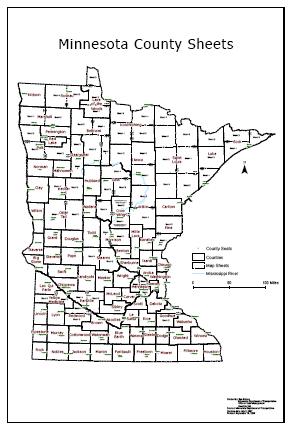
4 Minnesota Map Sheets Minnesota Map Sheet Reference


5 Map Sheet Numbering Minnesota County Map Sheet

6 Out-state County Map Sheets Iowa County Reference Map

7 Iowa County Map Sheet Manitoba Reference Map

8 Regional Municipality Map Sheet MN Map Legend
9 Background CAD Layer Symbols County Data Sheets


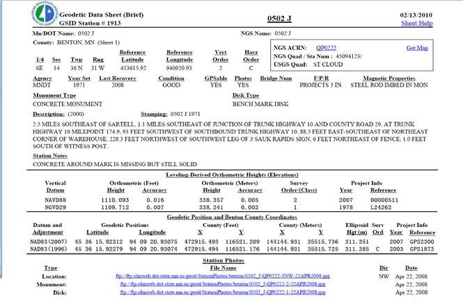
10 County Data Sheet- Full Form County Data Sheet- Brief Form

11 County Data Sheets - CSV County Data Sheets - CSV


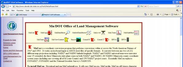

12 Using CSV Files in MnCon MnDOT OLM Softwares
 by")

13 Invoke Datasheet(s) by GS_ID in County Map County Index Sheets


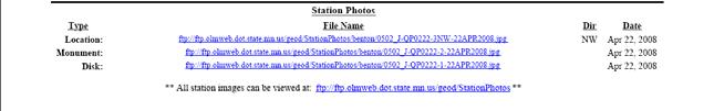
14 Specific County Index Sheet Station Photos


15 Station Photos Photo 1 - Disk


16 Photo 2 - Monument Photo 3 - Location
17 Geodetic Database Files and Viewer 1) Download Geodetic Database Data Files(Day-old) 1) County Data Sheets* 2) County Map Sheets(Manual update by Batch PDF Conversion) 3) County Index Sheets* 4) Station Photos* 2) Download Input Files(Day-old old) 1) Delorme Street Atlas USA 2) Maptech Terrain Navigator Pro 3) Google Earth 4) ArcMap 3) Interactive Geodetic Monument Viewer(Day-old) * Auto-updated by Virtual Chuck Download Delorme Street Atlas USA Input Files


18 Download Delorme Files Instructions how to input these files into Delorme at the bottom of this page Viewing Marks in Delorme
19 Geodetic Database Files and Viewer 1) Download Geodetic Database Data Files(Day-old) 1) County Data Sheets* 2) County Map Sheets(Manual update by Batch PDF Conversion) 3) County Index Sheets* 4) Station Photos* 2) Download Input Files(Day-old old) 1) Delorme Street Atlas USA 2) Maptech Terrain Navigator Pro 3) Google Earth 4) ArcMap 3) Interactive Geodetic Monument Viewer(Day-old) * Auto-updated by Virtual Chuck Download Maptech Terrain Navigator Pro Input File


20 Download the Maptech File Instructions on how to input the file into Maptech Viewing Marks in Maptech
 3) County Index Sheets* 4) Station Photos* 2) Download")
 Interactive Geodetic Monument Viewer(Day-old) * Auto-updated by Virtual Chuck Download KMZ (Google Earth)")
21 Geodetic Database Files and Viewer 1) Download Geodetic Database Data Files(Day-old) 1) County Data Sheets* 2) County Map Sheets(Manual update by Batch PDF Conversion) 3) County Index Sheets* 4) Station Photos* 2) Download Input Files(Day-old old) 1) Delorme Street Atlas USA 2) Maptech Terrain Navigator Pro 3) Google Earth 4) ArcMap 3) Interactive Geodetic Monument Viewer(Day-old) * Auto-updated by Virtual Chuck Download KMZ (Google Earth) Input Files
")


22 Download the KMZ (Google Earth) Files Geodetic Control File CORS Network File Viewing Geodetic Control in Google Earth


23 Viewing the CORS Network in Google Earth Geodetic Feature Service in ArcMap Only

24 Add or Export Geodetic Data (Other than ArcMap, request us to send you shapefiles. If you want MN basemap layers, go to the TDA website: dot.state.m n.us/maps/ gisbase/ht ml/datafiles.html) Database Manual
 County Map Sheets(Manual update by Batch PDF Conversion) 3) County Index Sheets* 4) Station Photos* 2) Download Input Files(Day-old) 1) Delorme Street Atlas USA 2) Maptech")
25 Geodetic Database Manual as of 2000 Under development Basic principles are still good Procedures have changed Geodetic Database Files and Viewer 1) Download Geodetic Database Data Files(Day-old) 1) County Data Sheets* 2) County Map Sheets(Manual update by Batch PDF Conversion) 3) County Index Sheets* 4) Station Photos* 2) Download Input Files(Day-old) 1) Delorme Street Atlas USA 2) Maptech Terrain Navigator Pro 3) Google Earth 4) ArcMap 3) Interactive Geodetic Monument Viewer(Day-old) * Auto-updated by Virtual Chuck
26 Interactive Geodetic Monument Viewer Splash Page

 View, select, & download geodetic monuments Monument data updated")
27 Geodetic Monument Viewer Geodetic Monument Viewer Free - viewed in your web browser Software driven by ArcGIS Server & GeoCortex Statewide spatial search (view scale <=180,000 & label scale <=70,000) View, select, & download geodetic monuments Monument data updated every night


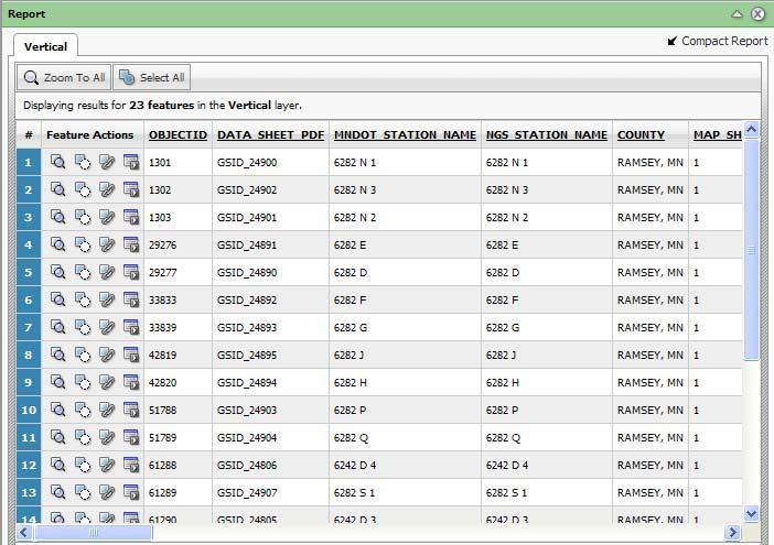
28 Geodetic Monument Matrix Report Format- Summary Table List
 What form a data viewing is live? Answer: ArcMap database link 4) What are the 6 categories of monuments?")
29 Watch for MnDOT Survey Tech Conference Any questions? If not, we have review questions for you. 1) Does MnDOT keep record of only MnDOT set marks? Answer: No 2. Is Minnesota the only state or providence MnDOT has Marks in? Answer: No 3) What form a data viewing is live? Answer: ArcMap database link 4) What are the 6 categories of monuments? Answer: HARN, 3D, Horizontal, Vertical, Other, Un-positioned. (See Slide 55) 5) How many report formats are there in the Interactive viewer? Answer: 3
30 Want to Talk to Us? Important Website Addresses: For Geodetic control marks, go to For MN basemap layers, go to Contact Information: Mar Alojado, SLS Office Phone: Theo Brown, LSIT Office Phone: Fax number:
Presenting Tree Inventory. Tomislav Sapic GIS Technologist Faculty of Natural Resources Management Lakehead University
 Presenting Tree Inventory Tomislav Sapic GIS Technologist Faculty of Natural Resources Management Lakehead University Suggested Options 1. Print out a Google Maps satellite image of the inventoried block
Frequently Asked Questions about MnDOT s Railroad Map Conversion Project
 Frequently Asked Questions about MnDOT s Railroad Map Conversion Project What were the main objectives of the project? What are the results and end products? What can these railroad maps be used for? Who
Iowa Department of Transportation Office of Transportation Data GIS / CAD Integration
 Iowa Department of Transportation Office of Transportation Data GIS / CAD Integration From GIS data to CAD graphics - Iowa DOT's workflow utilizing GeoMedia and MicroStation to develop map products. Mark
February 7, Jay Krafthefer, L.S.
 February 7, 2013 Jay Krafthefer, L.S. Introduction Background Web applications References Maps released on the Internet self-service not filed for record referenced by Commissioner s orders (Minn. Statute
V1.0. Session: Labelled Maps Verification, entering names into a GIS and Google Maps/Earth. Pier-Giorgio Zaccheddu
 Session: Labelled Maps Verification, entering names into a GIS and Google Maps/Earth V1.0 Pier-Giorgio Zaccheddu Federal Agency for Cartography and Geodesy (BKG) Richard-Strauss-Allee 11 60598 Frankfurt
GIS Functions and Integration. Tyler Pauley Associate Consultant
 GIS Functions and Integration Tyler Pauley Associate Consultant Contents GIS in AgileAssets products Displaying data within AMS Symbolizing the map display Display on Bing Maps Demo- Displaying a map in
Geo-enabling a Transactional Real Estate Management System A case study from the Minnesota Dept. of Transportation
 Geo-enabling a Transactional Real Estate Management System A case study from the Minnesota Dept. of Transportation Michael Terner Executive Vice President Co-author and Project Manager Andy Buck Overview
Digital Tax Maps Westport Island Project Summary
 Digital Tax Maps Westport Island Project Summary Presented to the: Mid-Coast Regional Planning Commission Creating GIS-Based Digital Tax Maps And Linked Assessment Records For Small Towns on a Budget Dennis
ARMSTRONG COUNTY, PA
 ARMSTRONG COUNTY, PA Revised Preliminary DFIRM Mapping March 31, 2013 Kevin Donnelly, P.E., CFM GG3, Greenhorne & O Mara, Inc. Presentation Agenda Armstrong County DFIRM Overview - June 25, 2010 DFIRM
Export Basemap Imagery from GIS to CAD
 Export Basemap Imagery from GIS to CAD This tutorial illustrates how to add high resolution imagery as a basemap into an existing CAD drawing using ArcGIS and AutoCAD. Through this method, the imagery
Gridded Ambient Air Pollutant Concentrations for Southern California, User Notes authored by Beau MacDonald, 11/28/2017
 Gridded Ambient Air Pollutant Concentrations for Southern California, 1995-2014 User Notes authored by Beau, 11/28/2017 METADATA: Each raster file contains data for one pollutant (NO2, O3, PM2.5, and PM10)
These modules are covered with a brief information and practical in ArcGIS Software and open source software also like QGIS, ILWIS.
 Online GIS Training and training modules covered are: 1. ArcGIS, Analysis, Fundamentals and Implementation 2. ArcGIS Web Data Sharing 3. ArcGIS for Desktop 4. ArcGIS for Server These modules are covered
Exercise 2: Working with Vector Data in ArcGIS 9.3
 Exercise 2: Working with Vector Data in ArcGIS 9.3 There are several tools in ArcGIS 9.3 used for GIS operations on vector data. In this exercise we will use: Analysis Tools in ArcToolbox Overlay Analysis
Tips and Tricks for Using ArcGIS for Fire Pre-Incident Planning Version II By: Chris Rogers Firefighter Kirkland Fire Department Kirkland Washington
 Tips and Tricks for Using ArcGIS for Fire Pre-Incident Planning Version II By: Chris Rogers Firefighter Kirkland Fire Department Kirkland Washington Abstract: The Kirkland Fire Department has been using
GIS at the Regional District
 GIS at the Regional District Amanda Spendiff Outline Introduction What is a Regional District? Our GIS department What does the GIS department do? Data management & mapping 9-1-1 fire/dispatch support
ArcGIS Earth an Intro
 ArcGIS Earth an Intro Chris Andrews Product Manager, 3D and ArcGIS Earth Brian Sims 3D Content Lead 3D across the Esri product family ArcGIS Pro 3D Analyst CityEngine ArcGIS for Server ArcGIS Online ArcGIS
Utilizing Data from American FactFinder with TIGER/Line Shapefiles in ArcGIS
 Utilizing Data from American FactFinder with TIGER/Line Shapefiles in ArcGIS Web Adams, GISP Data Dissemination Specialist U.S. Census Bureau New York Regional Office 1 What We Do Decennial Census Every
New Zealand Aeronautical Charting the ArcMap Challenge. Presenter: Beryl Pimblott Explorer Graphics Ltd
 New Zealand Aeronautical Charting the ArcMap Challenge Presenter: Beryl Pimblott Explorer Graphics Ltd Abstract This presentation will be on the production of a national series of Visual Navigation charts
Light and Optics. Light and Optics. Author: Sarah Roberts
 Activity Instructions Author: Sarah Roberts - Faulkes Telescope Project Activity Instructions Introduction In this activity, you will either search the image archive on the Faulkes Telescope Project website
Network Analysis with ArcGIS Online. Deelesh Mandloi Dmitry Kudinov
 Deelesh Mandloi Dmitry Kudinov Introductions Who are we? - Network Analyst Product Engineers Who are you? - Network Analyst users? - ArcGIS Online users? - Trying to figure out what is ArcGIS Online? Slides
GREENE COUNTY, PA. Revised Preliminary DFIRM Mapping FEMA. Kevin Donnelly, P.E., CFM GG3, Greenhorne & O Mara, Inc. April 10, 2013
 GREENE COUNTY, PA Revised Preliminary DFIRM Mapping April 10, 2013 Kevin Donnelly, P.E., CFM GG3, Greenhorne & O Mara, Inc. Presentation Agenda Greene County DFIRM Overview September 30, 2010 DFIRM Countywide
Overview. Everywhere. Over everything.
 Cadenza Desktop Cadenza Web Cadenza Mobile Cadenza Overview. Everywhere. Over everything. The ultimate GIS and reporting suite. Provide, analyze and report data efficiently. For desktop, web and mobile.
One platform for desktop, web and mobile
 One platform for desktop, web and mobile Search and filter Get access to all data thematically filter data in context factually and spatially as well as display it dynamically. Export a selection or send
GIS Workshop UCLS_Fall Forum 2014 Sowmya Selvarajan, PhD TABLE OF CONTENTS
 TABLE OF CONTENTS TITLE PAGE NO. 1. ArcGIS Basics I 2 a. Open and Save a Map Document 2 b. Work with Map Layers 2 c. Navigate in a Map Document 4 d. Measure Distances 4 2. ArcGIS Basics II 5 a. Work with
GIS Boot Camp for Education June th, 2011 Day 1. Instructor: Sabah Jabbouri Phone: (253) x 4854 Office: TC 136
 x 4854 Office: TC 136") GIS Boot Camp for Education June 27-30 th, 2011 Day 1 Instructor: Sabah Jabbouri Phone: (253) 833-9111 x 4854 Office: TC 136 Email: sjabbouri@greenriver.edu http://www.instruction.greenriver.edu/gis/ Summer
GIS Boot Camp for Education June 27-30 th, 2011 Day 1 Instructor: Sabah Jabbouri Phone: (253) 833-9111 x 4854 Office: TC 136 Email: sjabbouri@greenriver.edu http://www.instruction.greenriver.edu/gis/ Summer
DP Project Development Pvt. Ltd.
 Dear Sir/Madam, Greetings!!! Thanks for contacting DP Project Development for your training requirement. DP Project Development is leading professional training provider in GIS technologies and GIS application
Introduction to ArcGIS Server Development
 Introduction to ArcGIS Server Development Kevin Deege,, Rob Burke, Kelly Hutchins, and Sathya Prasad ESRI Developer Summit 2008 1 Schedule Introduction to ArcGIS Server Rob and Kevin Questions Break 2:15
Mapping Your Land and Introduction to Web Soil Survey. Elizabeth Cook GIS Specialist USDA-NRCS (retired)
") Mapping Your Land and Introduction to Web Soil Survey Elizabeth Cook GIS Specialist USDA-NRCS (retired) Using Geographic Information Systems (GIS), Global Positioning System (GPS), digital aerial photography
Mapping Your Land and Introduction to Web Soil Survey Elizabeth Cook GIS Specialist USDA-NRCS (retired) Using Geographic Information Systems (GIS), Global Positioning System (GPS), digital aerial photography
Week 8 Cookbook: Review and Reflection
 : Review and Reflection Week 8 Overview 8.1) Review and Reflection 8.2) Making Intelligent Maps: The map sheet as a blank canvas 8.3) Making Intelligent Maps: Base layers and analysis layers 8.4) ArcGIS
GIS CONCEPTS ARCGIS METHODS AND. 3 rd Edition, July David M. Theobald, Ph.D. Warner College of Natural Resources Colorado State University
 GIS CONCEPTS AND ARCGIS METHODS 3 rd Edition, July 2007 David M. Theobald, Ph.D. Warner College of Natural Resources Colorado State University Copyright Copyright 2007 by David M. Theobald. All rights
The Next Generation GIS/LIS A Surveys Information System Integrated within a GIS
 The Next Generation GIS/LIS A Surveys Information System Integrated within a GIS Michael F. WEIR, USA Key words: Linking, Snapping, GIS, Measurements, Measurement Data, GIS Features, Spatial Quality. SUMMARY
ArcGIS Online Routing and Network Analysis. Deelesh Mandloi Matt Crowder
 ArcGIS Online Routing and Network Analysis Deelesh Mandloi Matt Crowder Introductions Who are we? - Members of the Network Analyst development team Who are you? - Network Analyst users? - ArcGIS Online
EnvSci 360 Computer and Analytical Cartography
 EnvSci 360 Computer and Analytical Cartography Lecture 7 Mapping Images, Surfaces, and 3-D Data Brief Overview of Imagery What is Imagery? A spatial data model that defines space as an array of equally
ArcGIS Pro: Essential Workflows STUDENT EDITION
 ArcGIS Pro: Essential Workflows STUDENT EDITION Copyright 2018 Esri All rights reserved. Course version 6.0. Version release date August 2018. Printed in the United States of America. The information contained
Office of Geographic Information Systems
 Office of Geographic Information Systems Print this Page Spring 2009 - Desktop GIS: Dakota County GIS Extensions in ArcMap By Dan Castaneda In the past, the Office of GIS has created desktop extensions
Session Objectives. Learn how to: Bring georeferenced aerial imagery into Civil 3D. Connect to and import GIS data using various tools and techniques.
 GIS into Civil 3D Data 70th Annual Wisconsin Society of Land Surveyors' Institute January 24, 2019 1 Learn how to: Session Objectives Bring georeferenced aerial imagery into Civil 3D. Connect to and import
Elephant Rocks State Park (Missouri) Virtual Trip
 Virtual Trip") Elephant Rocks State Park (Missouri) Virtual Trip Objectives 1. Explain how the observed shapes, textures, and patterns of rock indicate the age of the earth and the large scale of geologic time. 2. Describe
Elephant Rocks State Park (Missouri) Virtual Trip Objectives 1. Explain how the observed shapes, textures, and patterns of rock indicate the age of the earth and the large scale of geologic time. 2. Describe
Identifying coordinate systems for data using ArcMap
 Chapter 1 Identifying coordinate systems for data using ArcMap I got a parcel shapefile from the county but it doesn t line up with my other data in ArcMap. My boss told me to make a map using ArcMap,
Delineation of high landslide risk areas as a result of land cover, slope, and geology in San Mateo County, California
 Delineation of high landslide risk areas as a result of land cover, slope, and geology in San Mateo County, California Introduction Problem Overview This project attempts to delineate the high-risk areas
Geoprovisioning delivers geodata and its analysis for specific areas on request.
 DRAFT 27 February 2009 Geoprovisioning Geoprovisioning delivers geodata and its analysis for specific areas on request. What are the components of a geoprovisioning service? The sample web site geoprovisioning.com
Demystifying ArcGIS Online. Karen Lizcano Esri
 Demystifying ArcGIS Online Karen Lizcano Esri An Integrated Web GIS Platform Desktop Web Device Powered by Services Managed via Portal Access from any Device Portal Server Online Content and Services ArcGIS
Lecture 3 GIS outputs. Dr. Zhang Spring, 2017
 Lecture 3 GIS outputs Dr. Zhang Spring, 2017 Model of the course Using and making maps Navigating GIS maps Map design Working with spatial data Geoprocessing Spatial data infrastructure Digitizing File
Lecture 9: Reference Maps & Aerial Photography
 Lecture 9: Reference Maps & Aerial Photography I. Overview of Reference and Topographic Maps There are two basic types of maps? Reference Maps - General purpose maps & Thematic Maps - maps made for a specific
ATLAS of Biochemistry
 ATLAS of Biochemistry USER GUIDE http://lcsb-databases.epfl.ch/atlas/ CONTENT 1 2 3 GET STARTED Create your user account NAVIGATE Curated KEGG reactions ATLAS reactions Pathways Maps USE IT! Fill a gap
GIS ADMINISTRATOR / WEB DEVELOPER EVANSVILLE-VANDERBURGH COUNTY AREA PLAN COMMISSION
 GIS ADMINISTRATOR / WEB DEVELOPER EVANSVILLE-VANDERBURGH COUNTY AREA PLAN COMMISSION SALARY RANGE INITIATION $43,277 SIX MONTHS $45,367 POSITION GRADE PAT VI The Evansville-Vanderburgh County Area Plan
Introduction to ArcGIS Maps for Office. Greg Ponto Scott Ball
 Introduction to ArcGIS Maps for Office Greg Ponto Scott Ball Agenda What is Maps for Office? Platform overview What are Apps for the Office? ArcGIS Maps for Office features - Visualization - Geoenrichment
Working with ArcGIS Online
 Esri International User Conference San Diego, CA Technical Workshops July 12, 2011 Working with ArcGIS Online Bern Szukalski, Deane Kensok Topics for this Session ArcGIS Online Overview ArcGIS Online Content
Geospatial Fire Behavior Modeling App to Manage Wildfire Risk Online. Kenyatta BaRaKa Jackson US Forest Service - Consultant
 Geospatial Fire Behavior Modeling App to Manage Wildfire Risk Online Kenyatta BaRaKa Jackson US Forest Service - Consultant Fire Behavior Modeling and Forest Fuel Management Modeling Fire Behavior is an
Teresa Santerre Hobby Manager
 Teresa Santerre Hobby Manager Sarita Hedgepeth Assistant Manager Charles Hill GIS Analyst Scott Lindsay Webmaster Work Completed BGS began by collecting historic well data in the Texas Hill Country from
Features and Benefits
 Autodesk LandXplorer Features and Benefits Use the Autodesk LandXplorer software family to help improve decision making, lower costs, view and share changes, and avoid the expense of creating physical
Please note: This presentation was used as speaker s notes for the 2008 Petroleum User Group Conference on Feb. 27, 2008 in Houston, TX.
 Please note: This presentation was used as speaker s notes for the 2008 Petroleum User Group Conference on Feb. 27, 2008 in Houston, TX. This material is not intended as course material nor reference material,
Exercise 2: Working with Vector Data in ArcGIS 9.3
 Exercise 2: Working with Vector Data in ArcGIS 9.3 There are several tools in ArcGIS 9.3 used for GIS operations on vector data. In this exercise we will use: Analysis Tools in ArcToolbox Overlay Analysis
Providing Public Access to King County GIS Data. Presented by: Michael Jenkins King County GIS Center Seattle, WA
 Providing Public Access to King County GIS Data Presented by: Michael Jenkins King County GIS Center Seattle, WA King County, Washington Microsoft Boeing Amazon.Com Starbucks Port of Seattle Weyerhauser
DATA APPLIANCE FOR ARCGIS
 DATA APPLIANCE FOR ARCGIS Data Appliance for ArcGIS Provides Access to Multi-Scale Basemaps Down to Medium Scale Levels Worldwide And Large Scale for Most of the World The Data Appliance includes Several
SoilView: Development of a Custom GIS Application for Publishing Soil Surveys
 SoilView: Development of a Custom GIS Application for Publishing Soil Surveys Allan Johnson and Mike Wigginton Abstract Currently, digital soils information can be obtained from many sources. Numerous
Leveraging the GIS Capability within FlexiCadastre
 Managing Local Land Concerns, Maintaining Corporate Governance Leveraging the GIS Capability within FlexiCadastre Regional User Conference, North America May 6 th May 9 th, 2013 Cameron McKellar, Technical
Displaying Latitude & Longitude Data (XY Data) in ArcGIS
 in ArcGIS") Displaying Latitude & Longitude Data (XY Data) in ArcGIS Created by Barbara Parmenter and updated on 2/15/2018 If you have a table of data that has longitude and latitude, or XY coordinates, you can view
Displaying Latitude & Longitude Data (XY Data) in ArcGIS Created by Barbara Parmenter and updated on 2/15/2018 If you have a table of data that has longitude and latitude, or XY coordinates, you can view
Fusion of Geodesy and GIS at NOAA s National Geodetic Survey
 Fusion of Geodesy and GIS at NOAA s National Geodetic Survey Esri Survey Summit July 6-9, 2013 San Diego, CA Michael Dennis, RLS, PE michael.dennis@noaa.gov The Plan Background NGS Data Explorer New Datasheet
When Map Quality Matters
 When Map Quality Matters 50% 25% Powerful geospatial mapping tools for Adobe Creative Cloud and offline map solutions for mobile devices 20% When Map Quality Matters 10% We re focused on creating powerful
Arboretum Explorer: Using GIS to map the Arnold Arboretum
 Arboretum Explorer: Using GIS to map the Arnold Arboretum Donna Tremonte, Arnold Arboretum of Harvard University 2015 Esri User Conference (UC), July 22, 2015 http://arboretum.harvard.edu/explorer Mission
Acknowledgments xiii Preface xv. GIS Tutorial 1 Introducing GIS and health applications 1. What is GIS? 2
 Acknowledgments xiii Preface xv GIS Tutorial 1 Introducing GIS and health applications 1 What is GIS? 2 Spatial data 2 Digital map infrastructure 4 Unique capabilities of GIS 5 Installing ArcView and the
Gridded Traffic Density Estimates for Southern
 Gridded Traffic Density Estimates for Southern California, 1995-2014 User Notes authored by Beau, 11/28/2017 METADATA: Each raster file contains Traffic Density data for one year (1995, 2000, 2005, 2010,
Task 1: Start ArcMap and add the county boundary data from your downloaded dataset to the data frame.
 Exercise 6 Coordinate Systems and Map Projections The following steps describe the general process that you will follow to complete the exercise. Specific steps will be provided later in the step-by-step
Student Activity Sheet- Denali Topo Map
 Student Activity Sheet- Denali Topo Map Directions: Follow the steps in order and answer the associated questions as you proceed through the activity. The first part of the activity will be guided by your
The econ Planning Suite: CPD Maps and the Con Plan in IDIS for Consortia Grantees Session 1
 The econ Planning Suite: CPD Maps and the Con Plan in IDIS for Consortia Grantees Session 1 1 Training Objectives Use CPD Maps to analyze, assess, and compare levels of need in your community Use IDIS
WlLPEN L. GORR KRISTEN S. KURLAND. Universitats- und Landesbibliothek. Bibliothek Architektur und Stadtebau ESRI
 hj WlLPEN L. GORR KRISTEN S. KURLAND Universitats- und Landesbibliothek Darmstadt Bibliothek Architektur und Stadtebau ESRI Contents Acknowledgments Preface xvii XV GIS Tutorial 1 Introduction Launch ArcMap
Arcgis Tutorial Manual READ ONLINE
 Arcgis Tutorial Manual READ ONLINE ArcGIS Desktop 10 Trial Help - Note: The Quick Start Guide contains instructions that do not pertain to the trial edition. Many tutorials are found in the ArcGIS Desktop
IDENTIFYING THE TYPE OF COORDINATE SYSTEM FOR DATA USING ARCMAP
 CHAPTER 1 IDENTIFYING THE TYPE OF COORDINATE SYSTEM FOR DATA USING ARCMAP I got a parcel shapefile from the county, but it doesn t line up with my other data in ArcMap. My boss told me to make a map using
What is CERA? Coastal Emergency Risks Assessment
 What is CERA? Coastal Emergency Risks Assessment Visualization tool using OGC standards Displays the outputs from the ADCIRC storm surge model or other coastal models Represents the maps on interactive
Problems and Challenges
 2018 Esri Petroleum GIS Conference Problems and Challenges May 9 10, 2018 Houston, Texas George R. Brown Convention Center Disunity of drawing standards and format Large amount of work in Cartography,
Plow Camera and Location Sharing Practices. National Rural ITS Conference October 23, 2018
 Plow Camera and Location Sharing Practices National Rural ITS Conference October 23, 2018 Outline NWP Program Overview Project Background Purpose What we did State Summaries ID, MT, ND, MN, IA, PA Project
GED 554 IT & GIS. Lecture 6 Exercise 5. May 10, 2013
 GED 554 IT & GIS Lecture 6 Exercise 5 May 10, 2013 Free GIS data sources ******************* Mapping numerical data & Symbolization ******************* Exercise: Making maps for presentation GIS DATA SOFTWARE
GPS Mapping with Esri s Collector App. What We ll Cover
 GPS Mapping with Esri s Collector App Part 1: Overview What We ll Cover Part 1: Overview and requirements Part 2: Preparing the data in ArcGIS for Desktop Part 3: Build a web map in ArcGIS Online Part
Geofacets EDUCATION & RESEARCH
 EDUCATION & RESEARCH Geofacets In academic institutions, geoscience departments are tasked with producing high-quality research, instilling best practice research principles in students, and preparing
Smart Data Collection and Real-time Digital Cartography
 Smart Data Collection and Real-time Digital Cartography Yuji Murayama and Ko Ko Lwin Division of Spatial Information Science Faculty of Life and Environmental Sciences University of Tsukuba IGU 2013 1
FlexiCadastre User Conference 2013 GIS Data Verification & Challenges
 FlexiCadastre User Conference 2013 GIS Data Verification & Challenges May 7, 2013 Amanda Blackmore GIS Specialist OVERVIEW GIS Definitions & Terminology Spatial Data Common Issues or Concerns Data Verification
ARCGIS PRO COURSE, APPLIED TO ENVIROMENTAL MANAGEMENT GIS. Course. Training. .com
 ARC PRO COURSE, APPLIED TO ENVIROMENTAL MANAGEMENT TYC Training Course.com TRAINING OVERVIEW This Arc Pro online course will provide a great deal of information about the link between earth s ecosystems
Contour Line Overlays in Google Earth
 Overview: Students download a section of a topographic map of their community from the ATEP website. This file will overlay the Google Earth satellite imagery. Students use the path tool to trace a contour
ArcGIS Online Tools and Water-Related Web Services You Can Use Every Day of Your Life!
 ArcGIS Online Tools and Water-Related Web Services You Can Use Every Day of Your Life! Brian Rowley, PE, CFM FMA 2014 Annual Conference 1 Gold Rush (49ers) John Sutter Sutter s Mill South fork of American
GIS Software. Evolution of GIS Software
 GIS Software The geoprocessing engines of GIS Major functions Collect, store, mange, query, analyze and present Key terms Program collections of instructions to manipulate data Package integrated collection
KING GEORGE COUNTY DEPARTMENT OF COMMUNITY DEVELOPMENT
 GIS REPORT 2017 KING GEORGE COUNTY DEPARTMENT OF COMMUNITY DEVELOPMENT Background The GIS (Geographic Information System) manager was hired in 2001 to develop a GIS for King George County. Prior to 2001,
Arcgis Enterprise Performance And Scalability Best Practices
 Arcgis Enterprise Performance And Scalability Best Practices We have made it easy for you to find a PDF Ebooks without any digging. And by having access to our ebooks online or by storing it on your computer,
INTRODUCTION TO GIS. Dartmouth College Research Computing
 INTRODUCTION TO GIS Dartmouth College Research Computing OVERVIEW Workshops GIS at Dartmouth What is GIS? Types of Data Referencing data to the earth: Datums, Map Projections, and Coordinate Systems Working
DGS Digital Geologic Information Resource (DGIR) User Guide
 User Guide") DGS Digital Geologic Information Resource (DGIR) User Guide Developed by the Delaware Geological Survey. Revised January 2012. TABLE OF CONTENTS I. INTRODUCTION II. DGIR LAYOUT III. TOOLBARS IV. USING
DGS Digital Geologic Information Resource (DGIR) User Guide Developed by the Delaware Geological Survey. Revised January 2012. TABLE OF CONTENTS I. INTRODUCTION II. DGIR LAYOUT III. TOOLBARS IV. USING
ArcGIS is Advancing. Both Contributing and Integrating many new Innovations. IoT. Smart Mapping. Smart Devices Advanced Analytics
 ArcGIS is Advancing IoT Smart Devices Advanced Analytics Smart Mapping Real-Time Faster Computing Web Services Crowdsourcing Sensor Networks Both Contributing and Integrating many new Innovations ArcGIS
An Introduction to the Community Maps Information Model
 Esri International User Conference July 23 27 San Diego Convention Center An Introduction to the Community Maps Information Model Seth Sarakaitis Agenda Overview of Community Maps Program Information Models
Hydroacoustic survey and bathymetric map creation for Brant Lake, New York
 Hydroacoustic survey and bathymetric map creation for Brant Lake, New York Holly A. Waterfield CLM 1 INTRODUCTION Brant Lake is located in Warren County, New York, within the bounds of the Adirondack Park.
Learning ArcGIS: Introduction to ArcCatalog 10.1
 Learning ArcGIS: Introduction to ArcCatalog 10.1 Estimated Time: 1 Hour Information systems help us to manage what we know by making it easier to organize, access, manipulate, and apply knowledge to the
Jo Daviess County Geographic Information System
 Introduction The Jo Daviess County Geographic Information System (GIS) offers a wide variety of products and services. The GIS program has a cost recovery policy in place to help maintain and continue
USING GIS TO UPDATE A FIELD SERVICES PRICING MODEL & LEVERAGING GIS TO SUPPORT FIELD DATA COLLECTION AND PUBLIC EDUCATION.
 USING GIS TO UPDATE A FIELD SERVICES PRICING MODEL & LEVERAGING GIS TO SUPPORT FIELD DATA COLLECTION AND PUBLIC EDUCATION John May, GISP THE CHALLENGE Since 1992 TxDOT has had to comply with NPDES requirements
Write a report (6-7 pages, double space) on some examples of Internet Applications. You can choose only ONE of the following application areas:
 on some examples of Internet Applications. You can choose only ONE of the following application areas:") UPR 6905 Internet GIS Homework 1 Yong Hong Guo September 9, 2008 Write a report (6-7 pages, double space) on some examples of Internet Applications. You can choose only ONE of the following application
UPR 6905 Internet GIS Homework 1 Yong Hong Guo September 9, 2008 Write a report (6-7 pages, double space) on some examples of Internet Applications. You can choose only ONE of the following application
Creating Watersheds from a DEM
 Creating Watersheds from a DEM These instructions enable you to create watersheds of specified area using a good quality Digital Elevation Model (DEM) in ArcGIS 8.1. The modeling is performed in ArcMap
MobileMapper 6. White Paper. MobileMapper 6 vs. Juno SC In Real World Conditions. Sub-Meter, Post-Processed Accuracy for less than 1,500 USD
 MobileMapper 6 White Paper MobileMapper 6 vs. Juno SC In Real World Conditions Sub-Meter, Post-Processed Accuracy for less than 1,500 USD Table of Contents Introduction...1 Testing Methodology...2 Test
Modeling Incident Density with Contours in ArcGIS Pro
 Modeling Incident Density with Contours in ArcGIS Pro By Mike Price, Entrada/San Juan, Inc. What you will need ArcGIS Pro 1.4 license or later ArcGIS Spatial Analyst license ArcGIS Online for organizational
Data Aggregation with InfraWorks and ArcGIS for Visualization, Analysis, and Planning
 Data Aggregation with InfraWorks and ArcGIS for Visualization, Analysis, and Planning Stephen Brockwell President, Brockwell IT Consulting, Inc. Join the conversation #AU2017 KEYWORD Class Summary Silos
Bentley Map Advancing GIS for the World s Infrastructure
 Bentley Map Advancing GIS for the World s Infrastructure Presentation Overview Why would you need Bentley Map? What is Bentley Map? Where is Bentley Map Used? Why would you need Bentley Map? Because your
Climate Risk Visualization for Adaptation Planning and Emergency Response
 Climate Risk Visualization for Adaptation Planning and Emergency Response NCR Flood Fact Finding Workshop Ricardo Saavedra ricardo@vizonomy.com Social Media, Mobile, and Big Data St. Peter s Basilica,
GIS Resources for Local Governments
 ISSUE PAPER SERIES GIS Resources for Local Governments February 2018 NEW YORK STATE TUG HILL COMMISSION DULLES STATE OFFICE BUILDING 317 WASHINGTON STREET WATERTOWN, NY 13601 (315) 785-2380 WWW.TUGHILL.ORG
Data Creation and Editing
 11.520:A Workshop on Geographical Information Systems 1.188: Urban Planning and Social Science Laboratory Data Creation and Editing Based in part on notes by Prof. Joseph Ferreira and Michael Flaxman Lulu
Laboratory Exercise - Temple-View Least- Cost Mountain Bike Trail
 Brigham Young University BYU ScholarsArchive Engineering Applications of GIS - Laboratory Exercises Civil and Environmental Engineering 2017 Laboratory Exercise - Temple-View Least- Cost Mountain Bike