Unit 5. Landscapes. 1. Name two types of landforms found in your region (see next page).
|
|
|
- Charles Walton
- 6 years ago
- Views:
Transcription

1 Unit 5. Landscapes The Iberian Peninsula contains a variety of different landforms and landscapes. the range from mountains in the north to volcanoes in the Canarias, with plateaus, hills and valleys in between. Man-made developments affect natural landscapes in many ways. can you thing of how we change natural landscapes? Activities: 1. Name two types of landforms found in your region (see next page). 2. Name Spain s two main archipelagos. 3. Name two benefits and two negative effects of man-made developments on natural landscapes. 1


2 Different landforms PLAIN VALLEY BAY MOUNTAIN CLIFF HILL 2


3 1. Read the descriptions and match them to the photos. a. People extract minerals and metals here. b. An area of sand of stones on the seashore. c. Where ships and boats are loaded, unloaded and repaired. d. A group of islands. 3


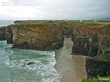
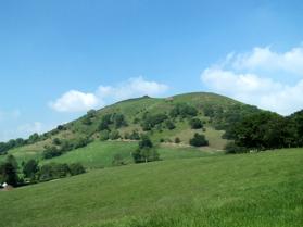
4 School project Look at the pictures and answer the questions Landscapes of Galicia These are two landscapes of Galicia. 1. Can you identify the natural and man-made features in them? Complete the table below with descriptions of the features that you recognise. Natural features Man-made features 2. What type of landscape has planted crops? Why? 3. What type of climate does the region in the pictures have? 4

5 Landforms Landforms are natural features of the Earth s surface. We can distinguish two main types of landforms: inland and coastal. They form very slowly over millions of years and can be affected by both natural and human developments. Identify the landforms in the picture below. 1. Mountains They are large inclines of rocky land that rise from the ground. The top of the mountain is called summit and the bottom is called the foot. A row of mountains forms a mountain range. 2. Hills They are small, rounded elevations of land. 3. Plateaus They are large high areas of flat land located more than 600 metres above sea level. 5
6 4. Valleys They are areas of low-lying land between mountains or hills. They often have a river flowing through them. If the land sinks below the surround area, it is called a depression. 5. Plains They are wide, flat stretches of land. They do not vary much in height and measure 200 metres above sea level or less. 6. Bays They are areas where the coastline curves inward and lets in the sea. Bays often have beaches, which are areas of low, flat land next too the sea. These are made of either sand or rocks. A big bay is called a gulf. 7. Headlands They are narrow pieces of land hat project from the coastline into the sea. When land rises abruptly from the sea and forms a wall of rock, we call it a cliff. 8. Islands An area of land completely surrounded by water. A group of islands is called an archipelago. 9. Peninsulas They are land surrounded by water on three sides. For example, the Iberian Peninsula. The strip of land that connects a peninsula to the mainland is calles and isthmus. 6
7 Activities 1. Name some landforms and describe how they are different from one another. 2. What s the difference between a valley and a depression? Point to the depression in the image above. 3. Find out how mountains form. Are there any mountains in your area? 4. What are the sides of a mountain called? 5. Which natural features can we find in coastal landscapes? 6. What does mainland mean? look at Cádiz on a map. Where is the mainland? 7. Look up some photos of these farmlands and make a presentation: plateau, isthmus, gulfs, bay archipelago, peninsula, island, volcano 8. Find a blank map of Galicia: Label the main examples of inland and coastal landscapes. 7


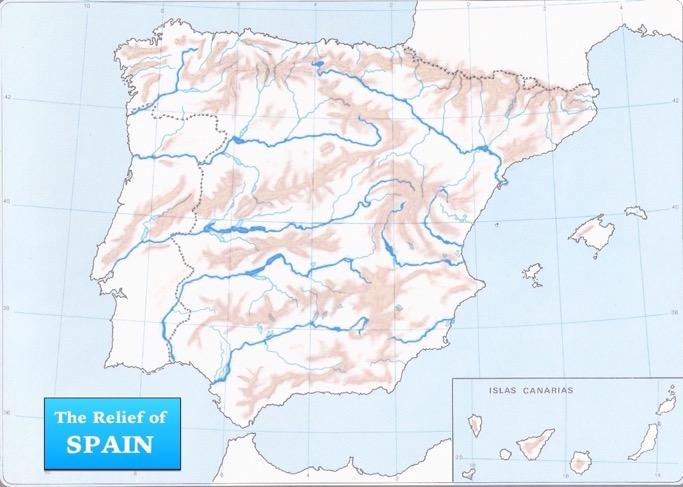
8 The physical geography of Spain The territory of Spain and its islands contain a great variety of landscapes and landforms. From plateaus to volcanoes, Spain s landscapes vary from region to region. these features greatly influence the climate and wildlife of each region, from Oceanic coastlines to continental interiors. Natural features There are two large archipelagos in Spain: the Islas Baleares and the Islas Canarias. 8

9 The highest summit in Spain, El Teide, is in the Islas Canarias. It is the third highest volcano in the world, at 3718 metres tall. The Desierto de Tabernas in Almería is one of the only a few deserts in Europe. Many western films were made in the Desierto de Tabernas. Activities 1. What is difference between an island and an archipelago. 2. What type of landform is the Meseta Central Central? And the Sistema Ibérico. Locate them in the map. 3. Where can we find volcanoes in Spain? Mountain ranges Mountain ranges on the Peninsula can be divided into three groups: Those around the edge of the Peninsula: the Pyrenees, the Macizo Galaico, the Montes Vascos and the Cordillera Costero-Catalana. Those on the Meseta central: the Sistema Central and the Montes de Toledo. Those on the edge of the Meseta Central: the Cordillera Cantábrica, the Sistema Ibérico, the Sistemas Béticos and Sierra Morena. Depressions The Depresión del Ebro is found between the Pyrenees and the Sistema Ibérico mountain ranges. The Depresión del Guadalquivir crosses a large area of Andalucía, from east to west. It is located between the Sierra Morena to the north and the Sistemas Béticos to the south. 9

10 It is the lowest depression in Spain, at an average of 100 above the sea level. It also contains Doñana National Park, which is found at the estuary of the Guadalquivir. Plateaus The Meseta Central is a big plateau located in the centre of the Iberian Peninsula. It is divided into the Submeseta Norte, which contains Castilla y León, and the Submeseta Sur, which is smaller and lower in elevation and contains the Comunidad de madrid, Castilla-La Mancha and Extremadura. Wildlifie The Sierra Morena and Doñana are some of the last remaining habitats of the Iberian Lynx. Many birds, such as eagles and vultures, libe in the Sistema Ibérico and the Pyrenees. Wild boards live in many different areas of the Península. Activities 4. Find out the name of the highest mountain in your autonomous community and its height in metres. 5. Research different animals in your region. Are they in danger of becoming extinct? What is their natural habitat? What landforms can we find there? 10


11 Human activity and man-made landscapes Today it is very difficult to find a landscape that is 100% natural because often people have changed them in some way. For example, any landscape with roads, buildings, structures or any that contain natural features that people have modified are called man-made landscapes. Look at the image below: Which features are man-made? BEFORE AFTER Man-made features These include: Infrastructures for transport, such as roads, motorways, railways, airports and docks. Roads and railways enable easy communication, which helps industry. Airports also benefit the economy by encouraging tourism. Man-made structures form villages, towns and cities. Urbanization generates economic activity by creating employment and the need for shops, supermarkets, hospitals, etc. Livestock farming and cultivating land on plains uses natural resources to produce food for people. Farming produces goods to sell, 11


12 such as vegetables, fruit, dairy products, meat and eggs. The production of nuclear, hydroelectric and thermoelectric energy also changes the landscape. Mines, dams and river diversions are examples of alterations to natural features. Activities 1. Which natural and man-made landscape features can you see from your classroom window? 2. Name some examples of man-made features that promote better communication. How do you think they help industry? 3. Name some positive and negative impacts of farming. Negative impacts While these man-made features are beneficial for most of us, some have negative impacts on the environment. Urbanisation. Large groups of people generate a lot of rubbish and waste that harm the environment. Urbanisation also disturbs animals natural habitats and can cause deforestation (cutting of trees). Industrial activity also produces waste, consumes energy and pollutes the atmosphere. Waste products, such as nuclear waste and industrial by-products, can pollute rivers, lakes 12

13 and seas. This harms wildlife. Transport heavily reduces the air quality because of the fumes it produces. Noise, air pollution and energy consumption are high in cities. Farming can cause deforestation and pollution due to cultivating the land and the use of fertilizers. Energy often comes from non-renewable sources that are mined, such as oil. These pollute the environment. Oil also harms wildlife when there is an oil spill. Activities 1. Find out what your autonomous community looked like 50 years ago. Which manmade developments have changed the landscape since then? Which are beneficial and which are harmful? 2. Research more about energy sources. Which two types exist? Where do they como from? How do they affect the landscape? 13
14 Find out: make pop-up facts Idea: make 3D pop-up cards about landforms in our local area. Materials ipad, reference books, newspapers A4 card or cardboard Scissors Glue/sticky tape Pencils Felt tips Ruler Process/carry out 1. Find about interesting facts about the geography of your region. Make sure there is something you can draw. 2. Fold your card in half and cut two parallel 10 cm strips, 5 cm apart. Design and cut out your landform. 3. Open your card and stick your landform on the strip. then write and number your facts on the card and decorate the page. Follow up 1. Visit some examples of the places you mention in your pop-up cards. Take your camera so you can take some photos. Add the photos to your cards. 2. Why do you think these places are well-known? Do many people visit them? What do they do there? Are there measures in place to protect these areas? 3. Plan a radio advert to promote the area you have chosen. 14

15 Review: 1. Copy and complete 2. Write the names of the landforms on the map of Spain. 1. Macizo 8. Sistemas 2. Cordillera 9. Submeseta 3. Montes de 10. Submeseta 4. P 11. D 5. Sistema 12. D 6. Sistema 13. Islas 7. Sierra 14. Islas 15
16 16
17 3. Identify and name the coastal and inland landforms. 4. Copy and complete the text in your notebook pollution food man-made consequences natural Most landscapes include both and features. Examples of benefits include better transport links, more jobs and mass production of. However, some include damaging local wildlife, creating and deforestation. 5. Order the words and test your classmates a. what s /between/ a /plateau /difference /and /plain /the? b. production/ name/ that/ man-made/ two/ enable/ changes/ of/ energy c. is/ a/ headland/ how/ different/ bay/ a/ from? d. enable/ list/ man-made/ that/ three/ transportation/ changes 17
4th GRADE MINIMUM CONTENTS- SOCIAL SCIENCE UNIT 3: LAND RELIEF
 LAND RELIEF 4th GRADE MINIMUM CONTENTS- SOCIAL SCIENCE UNIT 3: LAND RELIEF The outer layer of the Earth is composed of rocks and minerals. It is called the lithosphere or the Earth s crust. This layer
WHAT IS THE EARTH MADE OF? LITHOSPHERE AND HYDROSPHERE
 UNIT 8 WHAT IS THE EARTH MADE OF? LITHOSPHERE AND HYDROSPHERE TABLE OF CONTENTS 1 THE STRUCTURE OF THE EARTH... 2 2 THE FORMATION OF THE RELIEF: INTERNAL AND EXTERNAL FORCES.... 2 2.1 Internal forces:
Chapter 6, Part Colonizers arriving in North America found extremely landscapes. It looked different to region showing great.
 Social Studies 9 Unit 1 Worksheet Chapter 6, Part 1. 1. Colonizers arriving in North America found extremely landscapes. It looked different to region showing great. 2. The Earth is years old and is composed
About places and/or important events Landmarks Maps How the land is, hills or flat or mountain range Connected to maps World Different countries
 What do you think you know about geography? About places and/or important events Landmarks Maps How the land is, hills or flat or mountain range Connected to maps World Different countries What do you
4th Grade U.S. Regional Geography
 4th Grade U.S. Regional Geography Multiple Choice Identify the choice that best completes the statement or answers the question. What does the term mainland mean in the sentence above? A the continent
Developed in Consultation with Florida Educators
 Developed in Consultation with Florida Educators Table of Contents Next Generation Sunshine State Standards Correlation Chart... 7 Benchmarks Chapter 1 The Practice of Science...................... 11
Your web browser (Safari 7) is out of date. For more security, comfort and the best experience on this site: Update your browser Ignore
 is out of date. For more security, comfort and the best experience on this site: Update your browser Ignore") Your web browser (Safari 7) is out of date. For more security, comfort and the best experience on this site: Update your browser Ignore ISTHMU S tombolo For the complete encyclopedic entry with media resources,
Your web browser (Safari 7) is out of date. For more security, comfort and the best experience on this site: Update your browser Ignore ISTHMU S tombolo For the complete encyclopedic entry with media resources,
Earth s Layers. Earth s Surface
 CHAPTER 1 LESSON 3 Earth s Layers Earth s Surface Key Concepts What are Earth s major landforms and how do they compare? What are the major landform regions of the United States? What do you think? Read
Changes in Texas Ecoregions
 Comment On Lesson Changes in Texas Ecoregions The state of Texas can be divided into 10 distinct areas based on unique combinations of vegetation, topography, landforms, wildlife, soil, rock, climate,
UNIT 2 WARM UP. List the OCEANS. Bonus: Name the Largest LAKE on Earth
 UNIT 2 WARM UP List the OCEANS Bonus: Name the Largest LAKE on Earth Land Forms Land Mountain Hill Cliff Butte Mesa Plateau Cave Volcano Desert Plains Prairie Steppe Marsh Swamp Tundra Glacier Continent
Notes and Summary pages:
 Topographic Mapping 8.9C Interpret topographical maps and satellite views to identify land and erosional features and predict how these shapes may be reshaped by weathering ATL Skills: Communication taking
discussion of North America s physical features, including its landforms and bodies of
 Chapter 7 Natural Environments of North America Chapter 7 focuses on the natural environments of North America. The chapter opens with a discussion of North America s physical features, including its landforms
Sec$on 1: Geography and Early China. How does China s geography affect the culture?
 Sec$on 1: Geography and Early China How does China s geography affect the culture? Con$nents of the World Label the continents. Where is China located? Where is China located? In your groups, begin filling
(version 3) I. HumAN -Environment Interaction
 I. HumAN -Environment Interaction") (version 3) I. HumAN -Environment Interaction A. Landforms 1. Earth s topography is made up of many different types of landforms. 2. While the planet is covered primarily with water, the four major types
(version 3) I. HumAN -Environment Interaction A. Landforms 1. Earth s topography is made up of many different types of landforms. 2. While the planet is covered primarily with water, the four major types
Earth processes are dynamic actions that occur both on
 29 Weathering, Erosion, and Deposition R EA D I N G Earth processes are dynamic actions that occur both on the earth s surface and inside the earth. Any process that breaks down earth material, such as
Guided Reading Activity
 Guided Reading Activity Lesson 1 Physical Features Essential Question: How does geography influence the way people live? A Vast Land Directions: Read the lesson and use your text to decide whether each
Unit 1: Geography. For additional information, refer to this website: 1 G e o g r a p h y
 Unit 1: Geography For additional information, refer to this website: http://mryoungtms.weebly.com/ 1 G e o g r a p h y Continents and Oceans SOL USI. 2a Essential Understanding: Continents are large land
Most people used to live like this
 Urbanization Most people used to live like this Increasingly people live like this. For the first time in history, there are now more urban residents than rural residents. Land Cover & Land Use Land cover
All of Virginia's 4 main rivers flow into the... Chesapeake Bay. Along which river would Jamestown be found? James River. Appalachian Mountains
 All of Virginia's 4 main rivers flow into the... Along which river would Jamestown be found? The Blue Ridge Mountains and Valley and Ridge are part of what large mountain system? Define climate. Define
coast. It is warm and sunny in the centre of the peninsula etc.
 Practical Activity 1 What is the weather and how do we record it? Main Objective: 1. To differentiate between weather and climate; 2. To follow, read and interpret the weather Resources needed: A large
LANDFORM REGIONS IN CANADA. Classroom Notes and Descriptions
 LANDFORM REGIONS IN CANADA Classroom Notes and Descriptions Landform Regions in Canada There are eight distinct landforms in Canada: Western Cordillera Region Interior Plains Canadian Shield Hudson Bay
The United States & Canada. A Regional Study of Anglo America
 A Regional Study of Anglo America Landform Regions of the United States & Canada world leaders in agricultural and industrial production because of... VAST LANDS stretch from the Atlantic Ocean on the
Changes in Texas Ecoregions Copy the questions and answers
 Changes in Texas Ecoregions Copy the questions and answers 1. What are some kinds of damage that hurricanes cause? Roads and bridges might be washed away. Trees and power lines can be knocked down. Area
Changes to Land 5.7B. landforms: features on the surface of Earth such as mountains, hills, dunes, oceans and rivers
 All the landforms on Earth have changed over time and continue to change. Many of the changes were caused by wind, moving water, and moving ice. Mountains have grown and shrunk. Rivers have cut away land
Erosional Features. What processes shaped this landscape?
 Have you ever looked at the land around you and wondered what processes shaped what you see? Perhaps you see mountains, valleys, rivers, or canyons. Do you know how long these geologic features have been
Think about the landforms where you live. How do you think they have changed over time? How do you think they will change in the future?
 reflect All the landforms on Earth have changed over time and continue to change. Many of the changes were caused by wind, moving water, and moving ice. Mountains have grown and shrunk. Rivers have cut
Chapter 1: The Geography of the Western Hemisphere
 Chapter 1: The Geography of the Western Hemisphere Chapter 1, Lesson 1: The Changing Earth Objectives: - You will be able to identify the major natural events that cause the earth to change. - You will
Paper Reference. Paper Reference(s) 1312/2F Edexcel GCSE Geography A Foundation Tier. Monday 11 June 2007 Afternoon Time: 1 hour 15 minutes
 1312/2F Edexcel GCSE Geography A Foundation Tier. Monday 11 June 2007 Afternoon Time: 1 hour 15 minutes") Centre No. Paper Reference Surname Initial(s) Candidate No. 1 3 1 2 2 F Signature Paper Reference(s) 1312/2F Edexcel GCSE Geography A Foundation Tier Paper 2F Monday 11 June 2007 Afternoon Time: 1 hour
Centre No. Paper Reference Surname Initial(s) Candidate No. 1 3 1 2 2 F Signature Paper Reference(s) 1312/2F Edexcel GCSE Geography A Foundation Tier Paper 2F Monday 11 June 2007 Afternoon Time: 1 hour
netw rks Guided Reading Activity Essential Question: How does geography influence the way people live? Earth's Physical Geography
 Guided Reading Activity Lesson 1 Earth and the Sun Essential Question: How does geography influence the way people live? Looking at Earth Directions: What are the layers that make up Earth? Use your textbook
HOMEWORK CURRICULUM Geography
 HOMEWORK CURRICULUM Geography 2013-2014 Year 7 Term 1 Weather and Climate (will run 2-3 weeks into term 2) Make a mini weather station. Record the weather daily for 3 weeks Write a report on what the data
Paper Reference. Paper Reference(s) 1312/1F Edexcel GCSE Geography A Paper 1F Foundation Tier Monday 4 June 2007 Morning Time: 1 hour 45 minutes
 1312/1F Edexcel GCSE Geography A Paper 1F Foundation Tier Monday 4 June 2007 Morning Time: 1 hour 45 minutes") Centre No. Candidate No. Paper Reference 1 3 1 2 1 F Paper Reference(s) 1312/1F Edexcel GCSE Geography A Paper 1F Foundation Tier Monday 4 June 2007 Morning Time: 1 hour 45 minutes Materials required for
Centre No. Candidate No. Paper Reference 1 3 1 2 1 F Paper Reference(s) 1312/1F Edexcel GCSE Geography A Paper 1F Foundation Tier Monday 4 June 2007 Morning Time: 1 hour 45 minutes Materials required for
Weathering and Erosion
 Have you ever looked at the land around you and wondered how it was shaped? The geologic features that help define the world are still being shaped by the natural processes of weathering, erosion, and
How Geographers View the World: Human Geography. ESSENTIAL QUESTION: How does geography influence the way people live?
 How Geographers View the World: Human Geography ESSENTIAL QUESTION: How does geography influence the way people live? Geographers Think Spatially Gefffffdgfhfjgjp Guiding Question: What does it mean to
YEAR 7 GEOGRAPHY KNOWLEDGE BOOK
 YEAR 7 GEOGRAPHY KNOWLEDGE BOOK 1 P a g e WEATHER & CLIMATE The information here is what all students MUST know. Use this sheet as a checklist to identify what is clear to you, what you need to work on,
Grade 5 Hands on Science Weathering, Erosion and Deposition
 Grade 5 Hands on Science Weathering, Erosion and Deposition Objective: To demonstrate and investigate the effect of weathering, water and wind erosion and the subsequent deposition into landforms. Background:
EROSIONAL FEATURES. reflect
 reflect Have you ever looked at the land around you and wondered what processes shaped what you see? Perhaps you see mountains, valleys, rivers, or canyons. Do you know how long these geologic features
Vocabulary. geography. landform. plateau. climate. equator. Lesson Main Ideas What do they think about? What questions do they ask?
 Grade 5 U.S. History Chapter 1: America's Land Lesson 1: Land and Climate Objectives 1. Geography: Describe landforms and other physical features of the United States. 2. Geography: Explain how and why
PHYSICAL FEATURES OF EUROPE. Europe Unit
 PHYSICAL FEATURES OF EUROPE Europe Unit PENINSULA OF PENINSULAS Europe is a large peninsula that consists of many smaller peninsulas Most places in Europe are no more than 300 miles from an ocean or sea
Virginia Regions Study Guide
 Name/Number: Date: Virginia Regions Study Guide Standard VS.2a: SWBAT demonstrate knowledge of the physical geography and native peoples, past and present, of Virginia by locating Virginia and its bordering
Ta b l e o f C o n t e n t s
 Ta b l e o f C o n t e n t s Introduction..................................................................3 How to Use This Book.........................................................4 Standards Information.........................................................6
iv vi x Using maps 2 Using images and analysing data 6 Using new technologies in geography 8
 Contents Exam board specification map Introduction Topic checker iv vi x Geographical skills Using maps 2 Using images and analysing data 6 Using new technologies in geography 8 Natural hazards Tectonic
Landforms in Canada. Canada is made up of three dis;nct types of landforms: Canadian Shield Highlands Lowlands
 Canada s Landforms What is a Landform? A landform is any physical feature of the Earth s surface having a characteris;c, recognizable shape, produced by natural causes. Landforms include major features
Term Knowledge Using and applying Grade Criteria Autumn 1 Assessment window October Natural hazards pose major risks to people and property.
 Assessment Schedule Year 9 2015/6 Term Knowledge Using and applying Grade Criteria Autumn 1 Assessment window October 2015 3.1.1.2 Tectonic Natural hazards pose major risks to people and property. Definition
Essential Questions What are the major physical components of the world, and how are they represented on a map? 3.4
 Third Grade Social Studies Unit One Six Weeks GEOGRAPHY Originally compiled by Russellville In order for students to understand that geography influences the development of a region as well as the interactions
Drought lesson plan ITEMS. Teachers lesson plan. Student assignments. About droughts. Real life stories. Droughts: Be prepared.
 Drought lesson plan The drought lesson plan provides teachers and students with an opportunity to investigate the Australian climate, water table and the impacts of drought through individual or classroom
PALEOGEOGRAPHY of NYS. Definitions GEOLOGIC PROCESSES. Faulting. Folding 9/6/2012. TOPOGRAPHIC RELIEF MAP of NYS GRADATIONAL TECTONIC
 TOPOGRAPHIC RELIEF MAP of NYS PALEOGEOGRAPHY of NYS Prof. Anthony Grande AFG 2012 Definitions GEOLOGIC PROCESSES Geography: study of people living on the surface of the earth. Geology: the scientific study
ENVIRONMENT. Place, people, things and nature that surround any living organism GEOGRAPHY. Chapter
 Chapter 1 ENVIRONMENT Unit-1 : OUR ENVIRONMENT GEOGRAPHY Place, people, things and nature that surround any living organism is called its environment. It is a combination of natural and humanmade phenomena.
Explain the impact of location, climate, natural resources, and population distribution on Europe. a. Compare how the location, climate, and natural
 SS6G10 Explain the impact of location, climate, natural resources, and population distribution on Europe. a. Compare how the location, climate, and natural resources of Germany, the United Kingdom and
General Certificate of Secondary Education Higher Tier June 2011
 Centre Number Surname Candidate Number For Examiner s Use Other Names Candidate Signature Examiner s Initials Geography (Specification A) Unit 1 Physical Geography Monday 13 June 2011 For this paper you
name and locate the world s seven continents and five oceans
 Subject: Geography Activities National Curriculum Objectives One Progression of Skills Name the 7 continents and 5 oceans 3D Jigsaw task to locate continents and seas name and locate the world s seven
Class 4J Spring Term Irian Jaya/Papua New Guinea Adapted from QCA Geography Unit 10 incorporating some elements of Unit 25
 Class 4J Spring Term 2003 Geography Irian Jaya/Papua New Guinea Geography Unit 10 incorporating some elements of Unit 25 ABOUT THE UNIT In this unit children develop ideas about a less economically developed
Table of Contents. Introduction...3 How to Use This Book...4 Standards Information...6 The World in Spatial Terms
 Table of Contents Introduction...................................................................3 How to Use This Book..........................................................4 Standards Information...........................................................6
Landforms. Lesson 1: Physical Geography of Canada Mexico. Canada s mountainous eastern and western edges create a central region of fertile plains.
 Lesson 1: Physical Geography of Canada Mexico Landforms Canada s mountainous eastern and western edges create a central region of fertile plains. Collisions of tectonic plates thrust up a series of sharp-peaked
Range of Opportunities
 Geograhy Curriculum Cropwell Bishop Primary School Range of Opportunities Year 1 Year 2 Year 3 Year 4 Year 5 Year 6 All Key Stage 1 Key Stage 2 Investigate the countries and capitals of the United Kingdom.
Cambridge International Examinations Cambridge International General Certificate of Secondary Education
 Cambridge International Examinations Cambridge International General Certificate of Secondary Education *2660755211* GEOGRAPHY 0460/12 Paper 1 May/June 2018 Candidates answer on the Question Paper. Additional
Geography 8031/1 8031/1. (Jun ) AQA Level 1/2 Certificate June Dynamic Physical World TOTAL. Time allowed 1 hour
 AQA Level 1/2 Certificate June Dynamic Physical World TOTAL. Time allowed 1 hour") Centre Number Surname Candidate Number For Examiner s Use Other Names Candidate Signature Examiner s Initials AQA Level 1/2 Certificate June 2013 Geography 8031/1 Question 1 2 3 4 Mark Paper 1 Dynamic
Centre Number Surname Candidate Number For Examiner s Use Other Names Candidate Signature Examiner s Initials AQA Level 1/2 Certificate June 2013 Geography 8031/1 Question 1 2 3 4 Mark Paper 1 Dynamic
Class 4J Autumn Term St. Lucia Adapted from QCA Geography Unit 10 incorporating some elements of Unit 25
 Class 4J Autumn Term 2002 Geography St. Lucia Geography Unit 10 incorporating some elements of Unit 25 ABOUT THE UNIT In this unit children develop ideas about a less economically developed country. When
Geography Progression
 Geography Progression This document aims to track expectations for History within George Grenville Academy. What the National Curriculum says: KS1: Locational Knowledge: Name and locate the world s 7 continents
Unit 1: Geography GeoTrekkers in the Western Hemisphere. Illustrated Glossary
 Unit 1: Geography GeoTrekkers in the Western Hemisphere Illustrated Glossary adapt to change in order to fit new condi/ons archipelago a group or chain of islands clustered together in a sea or ocean bodies
Did You Ever Wonder? Landforms, C52. Slow Changes on Land, C58. Fast Changes on Land, C68
 \ - i -Vt1 t _ 9 \ "» y \R Landforms, C52 Slow Changes on Land, C58 Fast Changes on Land, C68 w -4 Did You Ever Wonder? What forces shaped these rocks? Wind and rain shaped them over thousands of years.
EXTERNAL LAND FORMING PROCESSES
 NAME SCHOOL INDEX NUMBER DATE EXTERNAL LAND FORMING PROCESSES WEATHERING 1 1998 Q 7 (a) (i) What is the difference between weathering and mass wasting (ii) List five processes involved in chemical weathering
Physical Geography: Patterns, Processes, and Interactions, Grade 11, University/College Expectations
 Geographic Foundations: Space and Systems SSV.01 explain major theories of the origin and internal structure of the earth; Page 1 SSV.02 demonstrate an understanding of the principal features of the earth
Cambridge International Examinations Cambridge International General Certificate of Secondary Education
 Cambridge International Examinations Cambridge International General Certificate of Secondary Education *9005889686* GEOGRAPHY 0460/12 Paper 1 May/June 2014 1 hour 45 minutes Candidates answer on the Question
Barlows Primary School Geography Curriculum Content Key Stage 1 and
 Geography Curriculum Content Key Stage 1 and 2 2017-2018 Curriculum Content Year 1 The content for Year 1 is detailed below: WHAT ARE SEASONS? WHAT SIT LIKE WHERE WE LIVE? WHERE DO DIFFERENT ANIMALS LIVE?
Different types of maps and how to read them.
 Different types of maps and how to read them. A map is a picture or representation of the Earth's surface, showing how things are related to each other by distance, direction, and size. Maps have been
Physical Geography of the United States and Canada Chapter 5 A Land of Contrasts
 Physical Geography of the United States and Canada Chapter 5 A Land of Contrasts Land Area Together the U.S. and Canada cover more than 7 million square miles. In total area, Canada ranks 2 nd and the
2008 SIVECO Romania. All Rights Reserved. Geography. AeL econtent Catalogue
 2008 SIVECO Romania. All Rights Reserved. Geography AeL econtent Catalogue The Earth's Movements Recommended for two hours of teaching. AeL Code: 352. 2. The Earth Rotation Movement in 24 hours 3. The
Read Across America. Listen as I read for facts about Volcanoes. In the Shadow of the Volcano
 Read Across America Listen as I read for facts about Volcanoes. In the Shadow of the Volcano Constructive & Destructive Processes Earth s surface is always changing. Blowing wind and flowing water causes
Erosion and Deposition
 CHAPTER 3 LESSON 2 Erosion and Deposition Landforms Shaped by Water and Wind Key Concepts What are the stages of stream development? How do water erosion and deposition change Earth s surface? How do wind
Science EOG Review: Landforms
 Mathematician Science EOG Review: Landforms Vocabulary Definition Term canyon deep, large, V- shaped valley formed by a river over millions of years of erosion; sometimes called gorges (example: Linville
Landscape evolution. An Anthropic landscape is the landscape modified by humans for their activities and life
 Landforms Landscape evolution A Natural landscape is the original landscape that exists before it is acted upon by human culture. An Anthropic landscape is the landscape modified by humans for their activities
SAMPLE QUESTION PAPER SET-II CLASS XII SUBJECT- GEOGRAPHY (029)
") SAMPLE QUESTION PAPER SET-II CLASS XII SUBJECT- GEOGRAPHY (029) 2015-2016 TIME ALLOWED- 3 HRS. MAXIMUM MARKS-70 General Instructions: I. There are 22 questions in all. II. III. IV. All questions are compulsory.
SAMPLE QUESTION PAPER SET-II CLASS XII SUBJECT- GEOGRAPHY (029) 2015-2016 TIME ALLOWED- 3 HRS. MAXIMUM MARKS-70 General Instructions: I. There are 22 questions in all. II. III. IV. All questions are compulsory.
SECTION A. Fig. 1 shows the position of some features in the south western part of the map extract.
 EXAMINATIONS COUNCIL OF SWAZILAND Swaziland General Certificate of Secondary Education CANDIDATE NAME CENTRE NUMBER CANDIDATE NUMBER GEOGRAPHY 6890/02 Paper 2 Geographical Skills October/November 2016
The structure of the Earth and how its motion creates the seasons. The landforms of the earth and the forces that shape the land.
 The structure of the Earth and how its motion creates the seasons. The landforms of the earth and the forces that shape the land. The role of wind and water in creating climate. The different climate and
Royal International School. Revision Booklet FINAL EXAMINATION. 2nd Semester Science - Grade 3A. Name: Prepared by: Ms.
 Royal International School Revision Booklet FINAL EXAMINATION 2nd Semester 2016-2017 Science - Grade 3A Name: Prepared by: Ms. Marvy 1 TABLE OF CONTENTS TOPIC Page How Does Earth s Surface Change Slowly?
Social Studies 9 UNIT 2 GEOGRAPHIC INFLUENCES ON IDENTITY: PLACE AND PEOPLE
 Social Studies 9 UNIT 2 GEOGRAPHIC INFLUENCES ON IDENTITY: PLACE AND PEOPLE The Structure of the Earth To understand the forces that create Canada's physical landscape we must understand the structure
e Southeast Region of the United Statesg
 e Southeast of the United Statesg - relative location: the location of a place in relation to another place (i.e. south, near, bordering, next to) - barrier islands: located off the southeast coast of
Of topic specific knowledge and understanding To encourage progressive development in 'thinking geographically'
 [August 2012] Content exemplars 1. Broad description of the content: Single paragraph, written with technical precision Content rigour (avoiding generic statements) Identifying the core of essential knowledge
Surface Events & Landforms. Mrs. Green
 Surface Events & Landforms Mrs. Green Bell Work 1) Which event MOST likely causes the slowest change to the surface of Earth? a) Earthquake b) Landslide c) Volcano d) Wind 2) When cold weather freezes
Geography Teach Yourself Series Topic 4: Global Distribution of Land Cover
 Geography Teach Yourself Series Topic 4: Global Distribution of Land Cover A: Level 14, 474 Flinders Street Melbourne VIC 3000 T: 1300 134 518 W: tssm.com.au E: info@tssm.com.au TSSM 2016 Page 1 of 7 Contents
Ancient China. Teachers Curriculum Institute Geography and the Early Settlement of China 1. AW_ISN_U04_01 Ancient China Second Proof TCI18 108
 G e o g r a p h y C h a l l e n g e Ancient China N W E S 0 250 500 miles 0 250 500 kilometers Albers Conic Equal-Area Projection AW_ISN_U04_01 Ancient China Second Proof TCI18 108 Teachers Curriculum
What type of land feature is located at Point A? A Cliff B Delta C Mountain D Valley
 1 What type of land feature is located at Point A? A Cliff B Delta C Mountain D Valley Alfred Wegener s theory of continental drift was 2 not accepted by scientists when the theory was first proposed.
Unit 1 Basic Geographical Concepts and Themes of Geography
 Unit 1 Basic Geographical Concepts and Themes of Geography Physical: Mount Everest Political: Nepalese Sherpa What is Geography? -Geography, simply put, is the study of the Earth s surface. This includes
What is a landform? These shapes (except for bodies of water) on the earth s surface are all examples of landforms.
 on the earth s surface are all examples of landforms.") Landforms What is a landform? These shapes (except for bodies of water) on the earth s surface are all examples of landforms. archipelago a large group of many islands. The Hawaiian Islands Lighthouse
Landforms What is a landform? These shapes (except for bodies of water) on the earth s surface are all examples of landforms. archipelago a large group of many islands. The Hawaiian Islands Lighthouse
Social Studies (4) Social Science
 Social Science") Scope And Sequence Timeframe Unit Instructional Topics 8 Day(s) Course Overview Students will learn about the regions of the United States with emphasis on local and state history, geography, government,
Scope And Sequence Timeframe Unit Instructional Topics 8 Day(s) Course Overview Students will learn about the regions of the United States with emphasis on local and state history, geography, government,
What is a landform? These shapes (except for bodies of water) on the earth s surface are all examples of landforms.
 on the earth s surface are all examples of landforms.") Landforms What is a landform? These shapes (except for bodies of water) on the earth s surface are all examples of landforms. archipelago a large group of many islands. The Hawaiian Islands Lighthouse
Landforms What is a landform? These shapes (except for bodies of water) on the earth s surface are all examples of landforms. archipelago a large group of many islands. The Hawaiian Islands Lighthouse
Land use study of Mellieha Valley
 Land use study of Mellieha Valley Fieldwork Report 1 Land use study of Mellieha Valley Location: Date: Time: Apparatus: Weather Conditions: Objectives / Aims: Geography Option Fieldwork E Gilson 2 2 Geological
Landform Project. Due Date: March 30, This is worth SS., Science, and LA grades!
 Landform Project Due Date: March 30, 2015. This is worth SS., Science, and LA grades! Create a map and a diorama in a pizza box to demonstrate landform meanings. Show and label landforms on both the map
Module 10: Resources and Virginia Geology Topic 4 Content: Virginia Geology Notes
 Virginia is composed of a very diverse landscape that extends from the beaches and barrier islands all of the way to the highly elevated Appalachian Plateau. Geologists have discovered ancient shallow
4th Grade Social Studies First Nine Weeks
 4th Grade Social Studies First Nine Weeks Multiple Choice Identify the choice that best completes the statement or answers the question. 1 Name the mountains that are located in the eastern United States.
Ancient China UNIT 4 GEOGRAPHY CHALLENGE. 1 Unit 4 Geography Challenge. Teachers Curriculum Institute
 UNIT 4 GEOGRAPHY CHALLENGE Ancient China N W E S 0 250 500 miles 0 250 500 kilometers Albers Conic Equal-Area Projection AW_ISN_U04_01 Ancient China Second Proof TCI18 108 1 Unit 4 Geography Challenge
Paper Reference. Paper Reference(s) 1312/4H Edexcel GCSE Geography A Higher Tier. Monday 11 June 2007 Afternoon Time: 1 hour 15 minutes
 1312/4H Edexcel GCSE Geography A Higher Tier. Monday 11 June 2007 Afternoon Time: 1 hour 15 minutes") Centre No. Paper Reference Surname Initial(s) Candidate No. 1 3 1 2 4 H Signature Paper Reference(s) 1312/4H Edexcel GCSE Geography A Higher Tier Paper 4H Monday 11 June 2007 Afternoon Time: 1 hour 15
Centre No. Paper Reference Surname Initial(s) Candidate No. 1 3 1 2 4 H Signature Paper Reference(s) 1312/4H Edexcel GCSE Geography A Higher Tier Paper 4H Monday 11 June 2007 Afternoon Time: 1 hour 15
Space. Earth. EARTH and EARTH and SPACE SPACE. Earth. William B. Rice
 Space Earth rth EARTH and EARTH and SPACE SPACE SCIENCE Earth is covered with mountains, canyons, and oceans. These landforms change over time. Mountains are made. Valleys may become deeper. Earth s landforms
Chapter 2 Planet Earth
 Chapter 2 Planet Earth Section Notes Earth and the Sun s Energy Water on Earth The Land Close-up The Water Cycle World Almanac Major Eruptions in the Ring of Fire Quick Facts Chapter 2 Visual Summary Video
Exploring Geography. Chapter 1
 Exploring Geography Chapter 1 The Study of Geography Geography is the study of where people, places, and things are located and how they relate to each other. Greek meaning writing about or describing
How to measure Territorial Cohesion and Cooperation?
 How to measure territorial cohesion and cooperation? How to measure Territorial Cohesion and Cooperation? Brussels: 21 February Growth, Development or Cohesion? Economic Competitiveness Social Cohesion
GUIDED READING CHAPTER 1: THE LAY OF THE LAND (Page 1)
") CHAPTER 1: THE LAY OF THE LAND (Page 1) Section 1 The Tidewater Region Directions: Use the information from pages 6-11 to complete the following statements. 1. In the southern part of the coast, the Tidewater
CHAPTER 1: THE LAY OF THE LAND (Page 1) Section 1 The Tidewater Region Directions: Use the information from pages 6-11 to complete the following statements. 1. In the southern part of the coast, the Tidewater
Socials Studies. Chapter 3 Canada s People 3.0-Human Geography
 Socials Studies Chapter 3 Canada s People 3.0-Human Geography Physical Geography Study of the natural features of the Earth s surface including landforms, climate, ocean currents and flora and fauna Human
Name Date Class. Directions: Use the diagram below to answer question Florida Progress Monitoring and Benchmark Assessments
 b e n c h m a r k t e s t : e a r t h a n d s p a c e s c i e n c e Multiple Choice 1. Geologists obtain indirect evidence about Earth s interior by A measuring pressure differences at Earth s surface.
CANADA S LANDFORM REGIONS
 CANADA S LANDFORM REGIONS Canada s Regions Canada is divided into Eight major regions. A Region is an area that is defined on the basis of the presence or absence of certain characteristics: Age of rock