Avalanches on Atlantis
|
|
|
- Prudence Rogers
- 6 years ago
- Views:
Transcription


1 Avalanches on Atlantis Real or Fake? The "true" story! Florian Thiery M.Sc.* Dipl.Geogr. Rania Taani** * i3mainz - Institute for Spatial Information and Surveying Technology ** Hochschule Mainz University of Applied Sciences,
 in")


2 That s me! Master Degree (Master of Science) in Geoinformatics and Surveying Research Associate at i3mainz Institute for Spatial Information and Surveying Technology Computer Scientist at RGZM Archaeological Research Institute 2


3 We are living in a world of»fake news«and»alternative facts«, also in history 3


4 But what is REAL, what is FAKE? 4

5 But is fake information always bad? 5

6 Have a look in books, there are fairy tales and myths ideas in mind with real facts 6

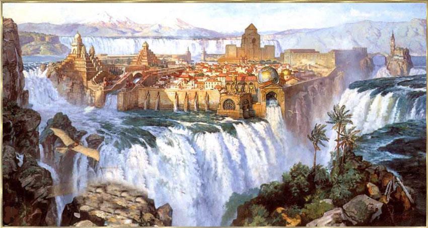
7 In Greek history, the famous philosopher Plato mentioned the mythical island Atlantis 7


8 Atlantis was a real empire, assigned to the sea god Poseidon 8


9 but only in Platon s mind, to show and explain his theories! 9

10 In geodesy we try to model and measure the real world as perfect as we can 10

11 but we all know, that it will never fit perfectly! 11


12 For demonstrating geodetic methods in GIS, we do not need real data, if it does not exist 12

13 we can use modelled, faked information for demonstrating anything we want! 13

14 In case of Atlantis, it is hard to get real spatial information out of Platon s work 14


15 because Atlantis could have looked like this 15

16 and modelled in a faked dataset like this: 16

17 The»AtlantGIS«dataset by Prof. Dr. phil. Kai-Christian Bruhn! 17


18 Imagine, you have real problems like avalanches threatening populated areas 18


19 just simulate and calculate demolition sites on Atlantis using the AtlantGIS dataset! 19

20 This was done in a students project by Rania as part of an interdisciplinary GIS module focusing on applications in Digital Humanites! 20


21 Rania s scenario One day, there was a great concern on Atlantis. Atlas and his twin brothers gathered for the annual island party at the king's palace as they heard a sound coming from the surrounding mighty mountains. It was an avalanche! Nothing happened, puh! Both were responsible for the well-being of their countrymen. Thus, they were obligated to deal with "avalanches". In order to make protective arrangements, areas prone to avalanches, had to be recorded. To analyse the recorded data, a GIS was established. As a result the demolition sites of avalanches have been calculated and will now be presented to the audience. 21


22 The investigation area, real and faked AtlantGIS Sokotra 22
23 The data is based on a Digital Terrain Model (DTM) for the visualization and analysis of the height, slope, terrain alignment and the vertical curvature current Landsat data for surface roughness (calculated using vegetation information) Data Set Landsat Archive, Pre-Collection, L8 OLI/TIRS QGIS, SAGA, GRASS, GDAL 23
24 Important characteristics of areas prone to avalanches are slope, surface design, snow depth, temperature, wind and the soil character (rubble &. Covering of vegetation) A multi criteria analysis was done for height slope terrain alignment vertical curvature surface roughness 24


25 The digital terrain model in pseudo colour 25


26 The calculations include reclassifications using QGIS Raster Calculator 26

27 Risk areas based on height avalanches occur at a certain altitude, which is oriented at the 0 C frost limit of the area; the higher, the more risk 27

28 Risk areas based on slope major influence! critical inclination for avalanches between 25 and 45 28
 highest risk, west slope (225-315 )")
 lowest risk")
29 Risk areas based on terrain alignment north slope ( ) highest risk, west slope ( ) second highest risk, south slope ( ) third highest risk and east slope ( ) lowest risk 29

30 Risk areas based on vertical curvature convex surfaces have higher risks, concave surfaces are more stable 30

, lower values")
31 Risk areas based on surface roughness calculation of the Normalized Difference Vegetation Index (NDVI), lower values higher risk 31

 * slope * roughness")
32 Classification based on multi criteria analysis demolition sites = (height + alignment + curvature) * slope * roughness 32


33 The resulting risk areas 33
34 Rania s conclusion the resulting map indicates higher avalanche risks in the north-western part of Atlantis. avalanches demolition areas are not the actual danger zones. Lead-out areas have to be included, too. the identified danger zones have to be identified and monitored. 34


35 My conclusion AtlantGIS is cool! use and extend it! 35
36 Avalanches on Atlantis Real or Fake? The "true" story!
37 License Information Except where otherwise noted, textural content on this presentation is licensed under a Creative Commons Attribution 4.0 International license. Image references are noted, if not Public Domain or self-produced. 37
38 Image References 1/4 Slide ALDODEL via fiverr.com Slide 3 Slide Slide 5 Slide 6 CC BY-SA 2.0 Arun Katiyar ( Slide
39 Image References 2/4 Slide 9 Slide 11 Slide Slide 13 Slide 14 Slide
40 Image References 3/4 Slide 16 CC BA-SA kacebe ( Slide 17 ( ) Slide Slide 20 Slide 21 Slide 22 and OpenStreetMap 40
41 Image References 4/4 Slide 26 By User:Anitagraser on QGIS Wiki, Antigraser ( [CC BY-SA 3.0 ( via Wikimedia Commons Slide
42 See also al/working_with_raster/raster_calculator.html 42
GIS sources for terrain analyses
 8.5. 11.5.2018 GIS sources for terrain analyses major Ing. Josef Rada University of Defence Brno Czech Republic 1 Introduction - Project of VGHMÚř and University of Defence; - objective: search for the
2013 Esri Europe, Middle East and Africa User Conference October 23-25, 2013 Munich, Germany
 2013 Esri Europe, Middle East and Africa User Conference October 23-25, 2013 Munich, Germany Environmental and Disaster Management System in the Valles Altos Region in Carabobo / NW-Venezuela Prof.Dr.habil.Barbara
Road Network Impedance Factor Modelling Based on Slope and Curvature of the Road
 Cloud Publications International Journal of Advanced Remote Sensing and GIS 2017, Volume 6, Issue 1, pp. 2274-2280 ISSN 2320 0243, Crossref: 10.23953/cloud.ijarsg.289 Methodology Article Road Network Impedance
Fuzzy Logic Method for Landslide Susceptibility Mapping, Rio Blanco, Nicaragua
 Fuzzy Logic Method for Landslide Susceptibility Mapping, Rio Blanco, Nicaragua H. Schernthanner 1 1 University of Potsdam, Institute of Geography, GIS department, Karl-Liebknecht-Str. 24/25, 14476 Golm
ESTIMATING LAND VALUE AND DISASTER RISK IN URBAN AREA IN YANGON, MYANMAR USING STEREO HIGH-RESOLUTION IMAGES AND MULTI-TEMPORAL LANDSAT IMAGES
 ESTIMATING LAND VALUE AND DISASTER RISK IN URBAN AREA IN YANGON, MYANMAR USING STEREO HIGH-RESOLUTION IMAGES AND MULTI-TEMPORAL LANDSAT IMAGES Tanakorn Sritarapipat 1 and Wataru Takeuchi 1 1 Institute
Warm-up Using the given data Create a scatterplot Find the regression line
 Time at the lunch table Caloric intake 21.4 472 30.8 498 37.7 335 32.8 423 39.5 437 22.8 508 34.1 431 33.9 479 43.8 454 42.4 450 43.1 410 29.2 504 31.3 437 28.6 489 32.9 436 30.6 480 35.1 439 33.0 444
Terrain Analysis through Maps.
 Terrain Analysis through Maps Need for Maps Theodolite Every Inch on Earth is Measured Maps are Prepared based on these Measurements Classification of Maps Function Scale Physical (Natural Features)
Algorithms for GIS csci3225
 Algorithms for GIS csci3225 Laura Toma Bowdoin College Spatial analysis: the beginnings Finding: nb. cholera deaths aer spatially clustered around the Broad St pump 1848, London, John Snow Claim: Cholera
Exploring geology: The story of the rocks and landscape of the Kettleman Hills
 Exploring geology: The story of the rocks and landscape of the Kettleman Hills Table of contents Lesson Plan Details Overview Overarching question Driving questions for students Module description Length
Surveying Prof. Bharat Lohani Department of Civil Engineering Indian Institute of Technology, Kanpur. Module - 4 Lecture - 1 Compass Surveying
 Surveying Prof. Bharat Lohani Department of Civil Engineering Indian Institute of Technology, Kanpur Module - 4 Lecture - 1 Compass Surveying Welcome to this video lecture series on basic surveying and
Cartographic analysis of avalanche hazard maps A comparison of relevant cartographic factors for the visualization of the avalanche bulletin
 Cartographic analysis of avalanche hazard maps A comparison of relevant cartographic factors for the visualization of the avalanche bulletin Markus Eckerstorfer, Karel Kriz University of Vienna, Department
Free Open Source Software for Geoinformatics (FOSS4G) A Practical Example System for Automated Geoscientific Analyses (SAGA)
 A Practical Example System for Automated Geoscientific Analyses (SAGA)") Free Open Source Software for Geoinformatics (FOSS4G) A Practical Example System for Automated Geoscientific Analyses (SAGA) Zlatko Horvat, MSc DGU Područni ured za katastar Čakovec My Motivation Give
Free Open Source Software for Geoinformatics (FOSS4G) A Practical Example System for Automated Geoscientific Analyses (SAGA) Zlatko Horvat, MSc DGU Područni ured za katastar Čakovec My Motivation Give
The Retreat of the Grinnell Glacier: 1990-Present
 Falk, Hepler, Lopez 1 Megan Falk, Alex Hepler, Michelle Lopez GSP 270/ Graham Group Project/ Final Draft December 8, 2014 Word count: 1,148 Introduction The Retreat of the Grinnell Glacier: 1990-Present
Modeling the post-ad 79 Deposits of Somma-Vesuvius to Reconstruct the pre-ad 79 Topography of the Sarno River Plain (Italy)
") of Somma-Vesuvius to Reconstruct the pre-ad 79 Topography of the Sarno River Plain (Italy) Sebastian Vogel German Archaeological Institute, Germany. sv@dainst.de Michael Märker University of Tübingen,
of Somma-Vesuvius to Reconstruct the pre-ad 79 Topography of the Sarno River Plain (Italy) Sebastian Vogel German Archaeological Institute, Germany. sv@dainst.de Michael Märker University of Tübingen,
Creating your own fairy tale. A step-by-step book for students grade 5-7. Created by Sean Holt Class: Prof. Heinz SoSe18 VocApps
 Creating your own fairy tale A step-by-step book for students grade 5-7. Created by Sean Holt Class: Prof. Heinz SoSe18 VocApps Task: Match the correct title. Beauty and Gretel Snow white and the Seven
Aldo Ferrero, Francesco Vidotto, Fernando De Palo. RUNOFF team
 TOPPS ACADEMY 15-1818 th June 2015 Grugliasco (TO) Aldo Ferrero, Francesco Vidotto, Fernando De Palo RUNOFF team DIAGNOSIS what data do we need? collection of territorial data (soils, elevation, slope,
HAPPILY EVER AFTER: THE PRINCESS AND THE PEA
 HAPPILY EVER AFTER: THE PRINCESS AND THE PEA Retold by Alex Field Illustrated by Helene Magisson Published by New Frontier Publishing SYNOPSIS The Prince travels the world looking for the perfect bride.
GLL THE STUDY OF METHODS FOR CORRECTING GLOBAL DIGITAL TERRAIN MODELS USING REMOTE SENSING DATA. I. Kolb, M. Lucyshyn, M. Panek
 GLL http://dx.doi.org/10.15576/gll/2013.3.59 Geomatics, Landmanagement and Landscape No. 3 2013, 59 66 THE STUDY OF METHODS FOR CORRECTING GLOBAL DIGITAL TERRAIN MODELS USING REMOTE SENSING DATA Ihor Kolb,
Mythology & Folklore: Legendary Tales
 Course Syllabus Mythology & Folklore: Legendary Tales Course Description Mighty heroes. Angry gods and goddesses. Cunning animals. Since the first people gathered around fires, mythology and folklore has
The Invasion of False Brome in Western Oregon
 The Invasion of False Brome in Western Oregon GIS II Presentation Winter 2006 Will Fellers Kurt Hellerman Kathy Strope Statia Cupit False Brome (Brachypodium sylvaticum) Perennial bunchgrass native to
Influence of Micro-Climate Parameters on Natural Vegetation A Study on Orkhon and Selenge Basins, Mongolia, Using Landsat-TM and NOAA-AVHRR Data
 Cloud Publications International Journal of Advanced Remote Sensing and GIS 2013, Volume 2, Issue 1, pp. 160-172, Article ID Tech-102 ISSN 2320-0243 Research Article Open Access Influence of Micro-Climate
( Your responses must be complete, using terminology and concepts.
 Running head: ARTICLE SUMMARY 1 Question Topic: Summary of information about website http://www.tulane.edu/~sanelson/geol204/masswastproc.htm Pages: 3 Sources: 4 Format: APA Deadline: 24 hours Instructions:
THE SALZKAMMERGUT A SHORT HISTORIC OVERVIEW. Austrian Service for Torrent and Avalanche Control, June 11th.2018:
 THE SALZKAMMERGUT A SHORT HISTORIC OVERVIEW Austrian Service for Torrent and Avalanche Control, June 11th.2018: Situation and history: The name Salzkammergut originates from the salt mining and salt refinery
Ancient Greece: Gods, goddesses and heroes
 Ancient Greece: Gods, goddesses and heroes By USHistory.org on 04.06.17 Word Count 958 Level MAX A painting by René-Antoine Houasse shows the gods Athena and Zeus. In Roman mythology, these gods were known
The Sleeping Beauty 3
 The Sleeping Beauty 2 The Sleeping Beauty 3 4 We d Love to Hear from You Richmond Ballet believes that a performance is a gift to the audience. Often when we receive a gift we write a thank you note. Our
Using Temperature and Dew Point to Aid Forecasting Springtime Radiational Frost and/or Freezing Temperatures in the NWS La Crosse Service Area
 Using Temperature and Dew Point to Aid Forecasting Springtime Radiational Frost and/or Freezing Temperatures in the NWS La Crosse Service Area WFO La Crosse Climatology Series #21 The formation of radiational
How to assess a snowpack with your group:
 This avalanche awareness curriculum was produced in partnership between the Colorado Mountain Club s Conservation Department s Backcountry Snowsports Initiative and Youth Education Program as well as the
Grant 0299-NEP: Water Resources Project Preparatory Facility
 Document Produced under Grant Project Number: 45206 May 2016 Grant 0299-NEP: Water Resources Project Preparatory Facility Final Report Volume 3 East Rapti (1 of 9) Prepared by Pvt. Ltd. For Ministry of
1. Introduction. Jai Kumar, Paras Talwar and Krishna A.P. Department of Remote Sensing, Birla Institute of Technology, Ranchi, Jharkhand, India
 Cloud Publications International Journal of Advanced Remote Sensing and GIS 2015, Volume 4, Issue 1, pp. 1026-1032, Article ID Tech-393 ISSN 2320-0243 Research Article Open Access Forest Canopy Density
USING GIS FOR AVALANCHE SUSCEPTIBILITY MAPPING IN RODNEI MOUNTAINS
 USING GIS FOR AVALANCHE SUSCEPTIBILITY MAPPING IN RODNEI MOUNTAINS IOANA SIMEA 1 ABSTRACT. Using GIS for avalanche susceptibility mapping in Rodnei Mountains. This case study combines GIS methods with
Multicriteria GIS Modelling of Terrain Susceptibility to Gully Erosion, using the Example of the Island of Pag
 14th International Conference on Geoinformation and Cartography Zagreb, September 27-29, 2018. Multicriteria GIS Modelling of Terrain Susceptibility to Gully Erosion, using the Example of the Island of
BASIC DETAILS. Morphometric features for landslide zonation A case study for Ooty Mettupalayam highway
 BASIC DETAILS Paper reference number : MWF PN 121 Title of the paper Name of the Presenter Author affiliation Mailing address Email address : Extraction of Topographic and Morphometric features for landslide
GeoExtreme. Geohazards, Climate Change and Extreme Weather Events
 GeoExtreme Geohazards, Climate Change and Extreme Weather Events Overview What is GeoExtreme? Involved processes What influences slide activity? Consequences for society? Ongoing work Conclusion What is
GIS Techniques for Avalanche Path Mapping and Snow Science Observations. By Douglas D. Scott AVALANCHE MAPPING/IDEA INTEGRATION
 GIS Techniques for Avalanche Path Mapping and Snow Science Observations GIS Techniques for Avalanche Path Mapping and Snow Science Observations. By Douglas D. Scott AVALANCHE MAPPING/IDEA INTEGRATION For
Monitoring Land Cover and Land Use in Central Asia Remote Sensing Contributions from selected German projects
 Monitoring Land Cover and Land Use in Central Asia Remote Sensing Contributions from selected German projects NASA LCLUC Meeting, Tashkent, 11.-13.11.2013 Christopher Conrad University of Würzburg, Institute
These Choice Boards cover the fourteen units for eighth grade Common Core math.
 A Note to the Teacher: Thank you so much for purchasing this Choice Board BUNDLE from The Math Station on Teachers Pay Teachers. I hope you like it! I started using choice boards last year and LOVE them!
GIS in Water Resources Midterm Exam Fall 2012 There are five questions on this exam. Please do all five.
 Page 1 of 6 Name: Key GIS in Water Resources Midterm Exam Fall 2012 There are five questions on this exam. Please do all five. Question 1 (a) You have worked with the location of Utah State University
USING LIDAR MEASUREMENTS FOR IMPROVING OR UP-DATING A DEM
 JAES_1(14)_3_2011 VAIS M. et. all, pp.123-128 SECTION Geodesic Engineering USING LIDAR MEASUREMENTS FOR IMPROVING OR UP-DATING A DEM VAIS Manuel*, IOSIF Gheorghe, Bucharest University, *e-mail: manuel.vais@sipg.ro
CONTENTS. How to Teach a Poem/Teaching Guidelines... 4 The Pleiades... 6 The Happy Farmer The Spider and the Fly... 22
 CONTENTS How to Teach a Poem/Teaching Guidelines... 4 The Pleiades... 6 The Happy Farmer... 10 The Hayloft... 14 Try, Try Again... 18 The Spider and the Fly... 22 Our House... 26 The Wind... 30 Untitled
Alignments of Master of Disaster (MoD) Lessons for Grades K-2 with the Next Generation Science Standards (NGSS) X X X X X X X X X X
 Lessons for Grades K-2 with the Next Generation Science Standards (NGSS) X X X X X X X X X X") Alignments of Master of Disaster (MoD) Lessons for Grades K-2 with the Next Generation Science Standards (NGSS) Relevant Next Generation Science Standards Performance Expectations* MoD Lesson Purpose K-PS2-1
Alignments of Master of Disaster (MoD) Lessons for Grades K-2 with the Next Generation Science Standards (NGSS) Relevant Next Generation Science Standards Performance Expectations* MoD Lesson Purpose K-PS2-1
Flood protection structure detection with Lidar: examples on French Mediterranean rivers and coastal areas
 Flood protection structure detection with Lidar: examples on French Mediterranean rivers and coastal areas Céline Trmal 1,a, Frédéric Pons 1 and Patrick Ledoux 1 1 Cerema, Direction Territoriale Méditerranée,
DEVELOPMENT OF LAND SUITABILITY EVALUATION SYSTEM FOR COASTAL AQUACULTURE USING ARTIFICIAL NEURAL NETWORK AND GEOGRAPHICAL INFORMATION SYSTEMS
 DEVELOPMENT OF LAND SUITABILITY EVALUATION SYSTEM FOR COASTAL AQUACULTURE USING ARTIFICIAL NEURAL NETWORK AND GEOGRAPHICAL INFORMATION SYSTEMS Case Study: Mahakam Delta, East Kalimantan I KETUT SUTARGA
 Physics The study of the energy, matter, and forces in the Universe Why do stars move in the sky? How can heat be changed into electricity? What is the difference between an atom of one substance and an
Year Group Overview. Year 3 Autumn 1 Tribal Tales
 Year 3 Autumn 1 Tribal Tales Geography Identify and compare physical features in different locations in the UK. Autumn 2 Scrumdiddlyumptious! globes and digital/computer mapping to locate countries and
Mythology, Epic, and Epic Hero. Mr. Pettine English 9 7 August 2015
 Mythology, Epic, and Epic Hero Mr. Pettine English 9 7 August 2015 Legend A traditional story sometimes popularly regarded as historical, but unauthenticated. Folktale A tale circulated by word of mouth
Session: Probabilistic methods in avalanche hazard assessment. Session moderator: Marco Uzielli Norwegian Geotechnical Institute
 Session: Probabilistic methods in avalanche hazard assessment Session moderator: Marco Uzielli Norwegian Geotechnical Institute Session plan Title Presenter Affiliation A probabilistic framework for avalanche
GEOG4017 Geographical Information Systems Lab 8 Spatial Analysis and Digital Terrain Modeling
 DEPARTMENT OF GEOGRAPHY HONG KONG BAPTIST UNIVERSITY Prof. Q. Zhou GEOG4017 Geographical Information Systems Lab 8 Spatial Analysis and Digital Terrain Modeling Objectives The exercise is designed to familiarize
The Wildlife Society Meet and Greet. Come learn about what the UNBC Student Chapter of TWS is all about!
 Georeferencing I GEOG 300, Lecture 4 Dr. Anthony Jjumba 1 The Wildlife Society Meet and Greet Quiz Come learn about what the UNBC Student Chapter of TWS is all about! 5:30 7:30 PM, Wednesday September
SHRI ANGALAMMAN COLLEGE OF ENGINEERING AND TECHNOLOGY (An ISO 9001:2008 Certified Institution) Siruganoor, Tiruchirappalli
 Siruganoor, Tiruchirappalli") SHRI ANGALAMMAN COLLEGE OF ENGINEERING AND TECHNOLOGY (An ISO 9001:2008 Certified Institution) Siruganoor, Tiruchirappalli 621 105. FS 81504 DEPARTMENT OF CIVIL ENGINEERING 1. Define remote sensing. CE-1304
SHRI ANGALAMMAN COLLEGE OF ENGINEERING AND TECHNOLOGY (An ISO 9001:2008 Certified Institution) Siruganoor, Tiruchirappalli 621 105. FS 81504 DEPARTMENT OF CIVIL ENGINEERING 1. Define remote sensing. CE-1304
EARTH SCIENCE. Glen Phelan
 EARTH SCIENCE Glen Phelan WALCH EDUCATION The classroom teacher may reproduce materials in this book for classroom use only. The reproduction of any part for an entire school or school system is strictly
When they compared their results, they had an interesting discussion:
 27 2.5 Making My Point A Solidify Understanding Task Zac and Sione were working on predicting the number of quilt blocks in this pattern: CC BY Camille King https://flic.kr/p/hrfp When they compared their
GIS Viewshed Analysis to Identify Zones of Potential Visual Impact on Protected Landscapes
 GIS Viewshed Analysis to Identify Zones of Potential Visual Impact on Protected Landscapes Background Natural England is consulted by local planning authorities on increasing numbers of development proposals,
1.02 Scientific Method
 1.02 Scientific Method Dr. Fred O. Garces Chemistry 100 Miramar College 1 Science and the meaning of life Ever since humans had the ability to think and reason, they have been trying to answer some basic
Using Morphometric models and Open Source Software to locate Flood prone areas A guide to pilot Implementation
 SciNetNatHaz Project Progress Meeting - 23-26 Oct 2014, Burgas, Bulgaria SciNetNatHaz Project Progress Meeting - 7-9 May 2015, Thessaloniki, Hellas Using Morphometric models and Open Source Software to
Fatmagül Batuk, Ozan Emem Department of Geodesy and Photogrammetry Engineering Tolga Görüm, Erkan Gökaan Natural Sciences Research Center
 Fatmagül Batuk, Ozan Emem Department of Geodesy and Photogrammetry Engineering Tolga Görüm, Erkan Gökaan Natural Sciences Research Center Landforms Landform term as used to denote a portion of the earth
Living Near a Volcano
 living near a volcano Grade Level 3-5 Grade Level 3-5 (1) 15 minute prep lesson (3) 45 minute lessons Lesson overview: Is it possible to build a volcano-safe home? In this lesson, students will learn about
Determination of flood risks in the yeniçiftlik stream basin by using remote sensing and GIS techniques
 Determination of flood risks in the yeniçiftlik stream basin by using remote sensing and GIS techniques İrfan Akar University of Atatürk, Institute of Social Sciences, Erzurum, Turkey D. Maktav & C. Uysal
1 Introduction: 2 Data Processing:
 Darren Janzen University of Northern British Columbia Student Number 230001222 Major: Forestry Minor: GIS/Remote Sensing Produced for: Geography 413 (Advanced GIS) Fall Semester Creation Date: November
Intro to GIS In Review
 Intro to GIS In Review GIS Analysis Winter 2016 GIS A quarter in review Geographic data types Acquiring GIS data Projections / Coordinate systems Working with attribute tables Data classification Map design
Delineation of high landslide risk areas as a result of land cover, slope, and geology in San Mateo County, California
 Delineation of high landslide risk areas as a result of land cover, slope, and geology in San Mateo County, California Introduction Problem Overview This project attempts to delineate the high-risk areas
USING HYPERSPECTRAL IMAGERY
 USING HYPERSPECTRAL IMAGERY AND LIDAR DATA TO DETECT PLANT INVASIONS 2016 ESRI CANADA SCHOLARSHIP APPLICATION CURTIS CHANCE M.SC. CANDIDATE FACULTY OF FORESTRY UNIVERSITY OF BRITISH COLUMBIA CURTIS.CHANCE@ALUMNI.UBC.CA
Erosion Susceptibility in the area Around the Okanogan Fire Complex, Washington, US
 Erosion Susceptibility in the area Around the Okanogan Fire Complex, Washington, US 1. Problem Construct a raster that represents susceptibility to erosion based on lithology, slope, cover type, burned
High Voltage DC Transmission Prof. Dr. S.N. Singh Department of Electrical Engineering Indian Institute of Technology, Kanpur
 High Voltage DC Transmission Prof. Dr. S.N. Singh Department of Electrical Engineering Indian Institute of Technology, Kanpur Module No. # 02 Lecture No. # 09 Analysis of Converter Circuit So, let us,
ESTIMATION OF LANDFORM CLASSIFICATION BASED ON LAND USE AND ITS CHANGE - Use of Object-based Classification and Altitude Data -
 ESTIMATION OF LANDFORM CLASSIFICATION BASED ON LAND USE AND ITS CHANGE - Use of Object-based Classification and Altitude Data - Shoichi NAKAI 1 and Jaegyu BAE 2 1 Professor, Chiba University, Chiba, Japan.
Open Source Software Education in Texas
 Open Source Software Education in Texas PHILLIP DAVIS / RICHARD SMITH GEOACADEMY The Challenge for Open Source Adoption OPEN SOURCE Less the 5% of US colleges and universities offer training in Free and
The seasons. Astronomy 101 Syracuse University, Fall 2017 Walter Freeman. September 11, Astronomy 101 The seasons September 11, / 24
 The seasons Astronomy 101 Syracuse University, Fall 2017 Walter Freeman September 11, 2017 Astronomy 101 The seasons September 11, 2017 1 / 24 Winter is coming. Watchwords of House Stark (A Song of Ice
Classification of Erosion Susceptibility
 GEO327G: GIS & GPS Applications in Earth Sciences Classification of Erosion Susceptibility Denali National Park, Alaska Zehao Xue 12 3 2015 2 TABLE OF CONTENTS 1 Abstract... 3 2 Introduction... 3 2.1 Universal
Section 0.6: Factoring from Precalculus Prerequisites a.k.a. Chapter 0 by Carl Stitz, PhD, and Jeff Zeager, PhD, is available under a Creative
 Section 0.6: Factoring from Precalculus Prerequisites a.k.a. Chapter 0 by Carl Stitz, PhD, and Jeff Zeager, PhD, is available under a Creative Commons Attribution-NonCommercial-ShareAlike.0 license. 201,
appstats27.notebook April 06, 2017
 Chapter 27 Objective Students will conduct inference on regression and analyze data to write a conclusion. Inferences for Regression An Example: Body Fat and Waist Size pg 634 Our chapter example revolves
Morphometric Analysis of Chamundi Hills, Mysuru, India Using Geographical Information System
 Volume-7, Issue-1, January-February 2017 International Journal of Engineering and Management Research Page Number: 279-283 Morphometric Analysis of s, Mysuru, India Using Geographical Information System
ACTIVITY 2: Motion with a Continuous Force
 CHAPTER 2 Developing Ideas ACTIVITY 2: Motion with a Continuous Force Purpose In Activity 1 you saw the effect that quick pushes had on the motion of a cart. This is like the situation in many sports,
European Space Agency
 Guidelines - Guidelines how/when to interact during the WebEx session: - Due to the number of attendees, please keep always your webcam and microphone switched-off - You can use anytime the chat to all
Alaska, USA. Sam Robbins
 Using ArcGIS to determine erosion susceptibility within Denali National Park, Alaska, USA Sam Robbins Introduction Denali National Park is six million acres of wild land with only one road and one road
Satellites, Weather and Climate Module??: Polar Vortex
 Satellites, Weather and Climate Module??: Polar Vortex SWAC Jan 2014 AKA Circumpolar Vortex Science or Hype? Will there be one this year? Today s objectives Pre and Post exams What is the Polar Vortex
Odd planetary alignment analysis of 2001: A Space Odyssey
 Odd planetary alignment analysis of 2001: A Space Odyssey My attention has been caught by, what I call, planetary alignment scenes, while re-watching 2001: A Space Odyssey for the second time. I have decided
This week s topics. Week 6. FE 257. GIS and Forest Engineering Applications. Week 6
 FE 257. GIS and Forest Engineering Applications Week 6 Week 6 Last week Chapter 8 Combining and splitting landscape features and merging GIS databases Chapter 11 Overlay processes Questions? Next week
The History of Astronomy
 The History of Astronomy http://www.phys.uu.nl/~vgent/babylon/babybibl_intro.htm http://mason.gmu.edu/~jmartin6/howe/images/pythagoras.jpg http://www.russellcottrell.com/greek/aristarchus.htm http://www.mesopotamia.co.uk/astronomer/homemain.html
MODELING DEM UNCERTAINTY IN GEOMORPHOMETRIC APPLICATIONS WITH MONTE CARLO-SIMULATION
 MODELING DEM UNCERTAINTY IN GEOMORPHOMETRIC APPLICATIONS WITH MONTE CARLO-SIMULATION Juha Oksanen and Tapani Sarjakoski Finnish Geodetic Institute Department of Geoinformatics and Cartography P.O. Box
Notes on Timaeus M. Baumer
 Notes on Timaeus M. Baumer I. About the Timaeus and Critias A. Timaeus, Critias, and Hermocrates were to form a connected series, but the Hermocrates was never written or at least does not survive, and
Geographers Perspectives on the World
 What is Geography? Geography is not just about city and country names Geography is not just about population and growth Geography is not just about rivers and mountains Geography is a broad field that
LANDSCAPE ECOLOGICAL MAPPING USING LIDAR DATA FOR BIODIVERSITY EVALUATION
 International Archives of the Photogrammetry, Remote Sensing and Spatial Information Science, Volume XXXVIII, Part 8, Kyoto Japan 2010 LANDSCAPE ECOLOGICAL MAPPING USING LIDAR DATA FOR BIODIVERSITY EVALUATION
Tutorial 8 Raster Data Analysis
 Objectives Tutorial 8 Raster Data Analysis This tutorial is designed to introduce you to a basic set of raster-based analyses including: 1. Displaying Digital Elevation Model (DEM) 2. Slope calculations
GIS Application in Landslide Hazard Analysis An Example from the Shihmen Reservoir Catchment Area in Northern Taiwan
 GIS Application in Landslide Hazard Analysis An Example from the Shihmen Reservoir Catchment Area in Northern Taiwan Chyi-Tyi Lee Institute of Applied Geology, National Central University, No.300, Jungda
Chapter 27 Summary Inferences for Regression
 Chapter 7 Summary Inferences for Regression What have we learned? We have now applied inference to regression models. Like in all inference situations, there are conditions that we must check. We can test
Regional influence on road slipperiness during winter precipitation events. Marie Eriksson and Sven Lindqvist
 Regional influence on road slipperiness during winter precipitation events Marie Eriksson and Sven Lindqvist Physical Geography, Department of Earth Sciences, Göteborg University Box 460, SE-405 30 Göteborg,
Merrimack College Astronomy 1101
 Merrimack College Astronomy 1101 Spring 2017 Ralph P. Pass 1 Lecture 5 - Outline Brief Review Constellations Coordinates Get to Galileo's Time 2 3 4 5 6 Observations Daily Stars Yearly Stars Yearly Snapshots
PROCESSES THAT SHAPE EARTH (4.ES.NGSS)
") TM PROCESSES THAT SHAPE EARTH (4.ES.NGSS) UNIT AT A GLANCE ACTIVITY 1 - Weathering and Erosion Detectives QUESTIONS: How can we make observations and collect data to provide evidence that the surface of
TM PROCESSES THAT SHAPE EARTH (4.ES.NGSS) UNIT AT A GLANCE ACTIVITY 1 - Weathering and Erosion Detectives QUESTIONS: How can we make observations and collect data to provide evidence that the surface of
DOWNLOAD OR READ : SCARY CREATURES OF THE MOUNTAINS PDF EBOOK EPUB MOBI
 DOWNLOAD OR READ : SCARY CREATURES OF THE MOUNTAINS PDF EBOOK EPUB MOBI Page 1 Page 2 scary creatures of the mountains scary creatures of the pdf scary creatures of the mountains SCARY CREATURES OF THE
Floodplain modeling. Ovidius University of Constanta (P4) Romania & Technological Educational Institute of Serres, Greece
 Romania & Technological Educational Institute of Serres, Greece") Floodplain modeling Ovidius University of Constanta (P4) Romania & Technological Educational Institute of Serres, Greece Scientific Staff: Dr Carmen Maftei, Professor, Civil Engineering Dept. Dr Konstantinos
Floodplain modeling Ovidius University of Constanta (P4) Romania & Technological Educational Institute of Serres, Greece Scientific Staff: Dr Carmen Maftei, Professor, Civil Engineering Dept. Dr Konstantinos
Object Based Imagery Exploration with. Outline
 Object Based Imagery Exploration with Dan Craver Portland State University June 11, 2007 Outline Overview Getting Started Processing and Derivatives Object-oriented classification Literature review Demo
The elevations on the interior plateau generally vary between 300 and 650 meters with
 11 2. HYDROLOGICAL SETTING 2.1 Physical Features and Relief Labrador is bounded in the east by the Labrador Sea (Atlantic Ocean), in the west by the watershed divide, and in the south, for the most part,
Exploring Geography. Chapter 1
 Exploring Geography Chapter 1 The Study of Geography Geography is the study of where people, places, and things are located and how they relate to each other. Greek meaning writing about or describing
DROUGHT RISK EVALUATION USING REMOTE SENSING AND GIS : A CASE STUDY IN LOP BURI PROVINCE
 DROUGHT RISK EVALUATION USING REMOTE SENSING AND GIS : A CASE STUDY IN LOP BURI PROVINCE K. Prathumchai, Kiyoshi Honda, Kaew Nualchawee Asian Centre for Research on Remote Sensing STAR Program, Asian Institute
SLOPE PROCESSES, LANDSLIDES, AND SUBSIDENCE
 CHAPTER 9 SLOPE PROCESSES, LANDSLIDES, AND SUBSIDENCE La Conchita slide January 10, 2005 Triggered by heavy rainfall, reactivation along an older landslide surface (35,000 years ago, 6000 years ago, and
Rio Santa Geodatabase Project
 Rio Santa Geodatabase Project Amanda Cuellar December 7, 2012 Introduction The McKinney research group (of which I am a part) collaborates with international and onsite researchers to evaluate the risks
Hydraulics Prof. Dr. Arup Kumar Sarma Department of Civil Engineering Indian Institute of Technology, Guwahati
 Hydraulics Prof. Dr. Arup Kumar Sarma Department of Civil Engineering Indian Institute of Technology, Guwahati Module No. # 04 Gradually Varied Flow Lecture No. # 07 Rapidly Varied Flow: Hydraulic Jump
Shalaby, A. & Gad, A.
 Urban Sprawl Impact Assessment on the Fertile Agricultural Land of Egypt Using Remote Sensing and Digital Soil Database, Case study: Qalubiya Governorate Shalaby, A. & Gad, A. National Authority for Remote
Results 2016 from SP 4 FoU Snøskred: Work Package 2 Statistical models
 Results 2016 from SP 4 FoU Snøskred: Work Package 2 Statistical models Project nr : 20140053-400 Title : Statistical approach for avalanche hazard zoning and warning Total budget (knok) From Dept. Of Oil
Earth and Space: Topographic Maps Satellite Images
 Earth and Space: Topographic Maps Satellite Images Earth and Space: Formative Assessment Activities for Earth and Space Topographic Maps Satellite Images Teacher Pages Purpose The purpose of this station
About places and/or important events Landmarks Maps How the land is, hills or flat or mountain range Connected to maps World Different countries
 What do you think you know about geography? About places and/or important events Landmarks Maps How the land is, hills or flat or mountain range Connected to maps World Different countries What do you