FRENCH NATIONAL REPORT TO THE 12 TH MEETING OF THE MESO AMERICAN AND CARIBBEAN SEA HYDROGRAPHIC COMMISSION MEETING
|
|
|
- Anis Walsh
- 6 years ago
- Views:
Transcription


1 SERVICE HYDROGRAPHIQUE ET OCEANOGRAPHIQUE DE LA MARINE DIRECTION DES MISSIONS INSTITUTIONNELLES ET DES RELATIONS INTERNATIONALES Dossier suivi par IETA Céline Roux Head of the external relations division Tel : Fax : Mél : celine.roux@shom.fr Paris, le 15 novembre 2011 N 020 SHOM/DMI/REX/NP FRENCH NATIONAL REPORT TO THE 12 TH MEETING OF THE MESO AMERICAN AND CARIBBEAN SEA HYDROGRAPHIC COMMISSION MEETING Hydrographic Service: General SHOM, the French hydrographic service, was created in 1720 and used to report to the French Navy. It became a public service in 2007 with goals and budget set by a board of directors composed of representatives from various French ministries and organisations. A contract of targets and performance between SHOM and the Minister of Defence covering will be superseded to cover SHOM abides by the rules set for France by the International Maritime Organisation, and in particular by the SOLAS convention, specifying the obligation for coastal States to provide navigators with hydrographic services. SHOM is dedicated to guaranty the quality and the availability of information describing marine physical environment, along the coast and offshore, while coordinating its collection, filling and release. SHOM continuously ensures that public, civilian and military needs are satisfied at the lowest possible cost. SHOM fulfils the missions of a national hydrographic service, supports defence and provides expertise to maritime policies. As a public service, SHOM can interact with other French geography, meteorology and oceanography specialists as well as with its European and international counterparts. SHOM 13 rue du Chatellier - CS BREST CEDEX 2 BCRM de BREST - SHOM - CC BREST CEDEX 9
 and SHOM were tasked by the Prime Minister to join efforts to produce a seamless, precise topographic and bathymetric model, of the entire French coast.")
2 2. Surveys 2.1. Coverage of new surveys The new surveys in the area since the last meeting are presented in the next paragraph New technologies and /or equipment The French National Geographic Institute (IGN) and SHOM were tasked by the Prime Minister to join efforts to produce a seamless, precise topographic and bathymetric model, of the entire French coast. The Litto3D project was then created to meet more than hundred requirements expressed by coastal managers concerned with the protection and exploitation of the littoral, and by users of geo-referenced data. Hereunder are some results of bathymetric and topographic LIDAR in Martinique: 2/13
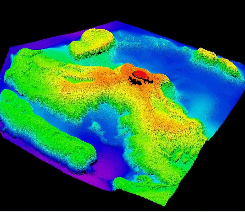
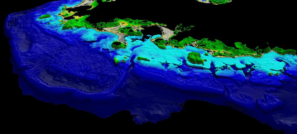
3 For Guadeloupe, the survey results are as follows: 3/13
.")
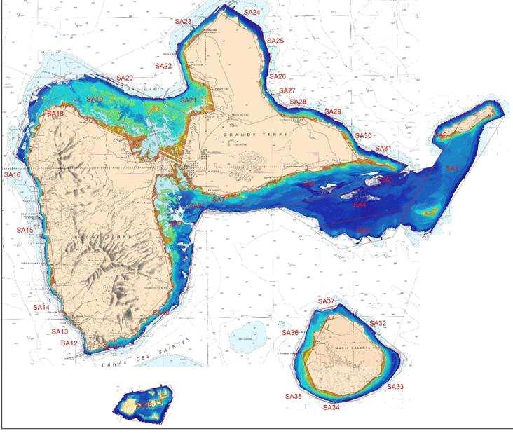
4 Should you require more information please contact 2.3. New ships 2.4. Problems encountered 3. New charts & updates 3.1. ENCs SHOM s collection of ENCs has now reached the number of 335 (some ENCs already produced have been merged to better follow the existing paper chart scheme). The approximate rate of production is of 40 ENCs per year. The full collection should eventually reach a figure around 850 ENCs. In line with the WEND recommendations and guidelines, France produces its small scale ENC cells as closely as possible to INT chart schemes. The status of ENC production in the area is: Usage Band Produced Cells Planned Cells % N/A % % % % 6 2 Total % The SHOM ENC coverage of the MACHC area is depicted in the chartlets hereafter, where existing ENCs are represented in dark pink and planned ENCs for are in light pink. 4/13

5 FR ENC (Clipperton Island in the Pacific Ocean) not depicted in the chartlets above, is also planned for This ENC will be clipped to the existing ENCs. Since the last MACHC conference, ENCs FR374840, FR374850, FR474710, FR and FR67481A have been produced. 5/13

6 Following is an extract of the online PRIMAR catalogue : FR57472E FR FR FR FR FR FR FR FR FR FR56948A FR57102F FR FR FR FR FR FR FR FR FR67481A FR FR FR FR ENC Distribution method All French ENCs are distributed to End User Service Providers through PRIMAR RENC. France is providing its support to develop a RENC-to-RENC cooperation concept, within the WEND-WG, following the tasks carried out by the IC-ENC-PRIMAR Cooperation Committee RNCs 3.4. INT charts See next section National paper charts No new chart has been produced since the last meeting. A new chart FR7751 covering the French Clipperton Island (scale 1: ) is currently being prepared and the equivalent ENC cell is planned to be produced in No paper chart in the MACHC region is planned to be produced next year. However, possible new editions of the charts FR7377 (scale 1: Ports du Larivot et de Cayenne) and FR7378 (scale 1 : Accès à Dégrad des Cannes) could be undertaken Other charts, e.g. for pleasure craft 3.7. Problems encountered As many other IHO member states, France is responsible for collecting nautical information and surveying areas that would otherwise remain uncharted. It happens from time to time that SHOM only learns by accident of surveys performed by private companies, or even other hydrographic offices, in its areas of charting responsibility, and has to insist to obtain communication of IHO-compliant data relevant to INT charts and nautical information. In the interest of the international maritime community, it is reminded that survey results should be automatically communicated to the IHO recognised and primary charting authority (in accordance with M-3 resolution 1/2006 and S-4 resolution A and B ). 6/13
7 In addition, provision should be made in all contracts awarded to private survey companies to the effect that hydrographic data pertinent to the safety of navigation be communicated to the IHO recognised charting authority. 4. New publications & updates 4.1. New Publications 4.2. Updated publications The new edition, released in 2011, of the list of lights entitled LD has a reduced coverage compared to the former publication: it covers Antilles, Guyane and Saint-Pierre-et- Miquelon Means of delivery SHOM aims at generating by digital means its entire paper production. This should be achieved by using international standards such as XML and following closely the recommendations of experts such as the IHO Standardization of Nautical Publications Working Group (SNPWG) in which SHOM participates Problems encountered An important regulation corpus has been developed for the establishment and use of ENCs while the equivalent standardisation for nautical books is still lagging. As a result, the rules of use of these documents are not clearly established. 5. MSI Existing infrastructure for transmission Available information about lights and beacons along the Maroni river was sent on request to the Surinam authorities New infrastructure in accordance with GMDSS Master Plan 5.2. Problems encountered 6. C-55 Latest update The C-55 database for French areas of responsibilities is normally updated by SHOM on a yearly basis. Separate entries are now available for French areas in each IHO region. 7. Capacity Building Offer of and/or demand for Capacity Building 7.1. Training received, needed, offered SHOM provided to Haiti a hydrography and nautical cartography training course, at Ouanga Bay beach hotel in Carriès on the 5th and 16th of September This workshop was part of the Haitian cartographic service reconstruction, after the earthquake of January The goals of this workshop were: The training of a surveyors team able to autonomously realize a single beam and side scan sonar survey, in order to update existing nautical charts in Haiti; The training of a nautical cartography team able to update an existing ENC covering Haiti area (ENC derived from a pre-existing DNC1). The number of person trained to hydrography during the workshop reached a total of 18. All trainees proved their great interest and motivation for the training, and their will to improve 7/13
 and the cartography (right) trainees with the SHOM staff sent to provide the tuition: The")
.")


8 their knowledge in hydrography and cartography as well as to develop the SHOH (Service Hydrographique et Océanographique de Haiti). Hereunder are photographs taken of the hydrography (left) and the cartography (right) trainees with the SHOM staff sent to provide the tuition: The Haiti coast guard provided for the workshop a launch together with its own crew, usable as a survey launch after installation of the EA400 on a pole: An extensive report on this topic was sent by SHOM to the CBSC chair last month (see report N 174 SHOM/DRH/FOR/NP dated 10th October 2011). Initial training capabilities provided by SHOM are described in its yearly report available on Status of national, bilateral, multilateral or regional development projects with hydrographic component SHOM is participating in the deployment of instruments for the benefit of the future Caribbean Tsunami Warning Centre through the INTERREG IV programme. It is financed by the European FEDER budget and SHOM is associated with the Institut Physique du Globe of Paris, Martinique s general council, Météo-France and the Seismic Research Centre of the University of West Indies (see paragraph 9.3). 8/13
 in the Salut islands (Guyane). A draft preliminary agreement was sent to Suriname for their consideration. 7.3. Definition of bids to IHOCBC 8. Oceanographic activities 8.")

9 In order for this centre to receive tide gauges measurements in real time, satellite beacons will be installed beginning of 2012 on the existing SHOM tide gauges in Fort-de-France (Martinique), Pointe-à-Pitre (Guadeloupe) in the Salut islands (Guyane). A draft preliminary agreement was sent to Suriname for their consideration Definition of bids to IHOCBC 8. Oceanographic activities 8.1. GEBCO/IBC s activities 8.2. Tide gauge network SHOM is the French national coordinator and reference authority in the field relating to the observation of the sea level and the management and issue of the resulting data. These missions are carried out under the REFMAR programme. Real time and processed tide gauge measurements are now accessible on the web in all areas around the world under French jurisdiction as shown hereunder: SHOM released in 2010 a new edition of the tidal prediction software SHOMAR (for 150 metropolitan France harbours and more than overseas and foreign harbours). SHOM also provides real time services for sea state, sea levels, sea surface currents, associated forecasts and prediction on New equipment 8.4. Problems encountered 9/13

10 9. Other activities 9.1. Meteorological data collection 9.2. Geospatial studies 9.3. Disaster prevention Tsunami : SHOM contributes to the launching of the national tsunami warning centre for the Caribbean. The importance of the expansion of the real-time SHOM tide gauge network named RONIM is recognised as a key component for the development of a national tsunami warning system. SHOM currently acts as the French national coordinator of sea level measurements, due to its national responsibility to conduct surveys, to maintain RONIM and to make and distribute the official tidal predictions. RONIM is recognized as an important tool for coastal operational oceanography, risk assessment, studies on the evolution of the mean sea level, etc. This role was materialised in 2009 with the launch of the CRATANEM project, which aims at setting up a national warning centre for tsunamis for the North Eastern Atlantic and the Mediterranean. SHOM is a partner of this project with four other French agencies. France may have Navy ships in the MACHC region ready to provide support in case of an emergency. France also provides technical support and has a rapid response capacity for environmental data in case of a disaster. The point of contact at SHOM in case of a disaster is Cdr Bertrand Menanteau. His division can be reached 24/7 by fax or coord.navarea2@shom.fr Coastal flooding : SHOM is associated with Météo-France in the provision of an alert system against coastal flooding named Vigilance Vagues Submersion. This allows for a better anticipation of this destructive phenomenon and protection of the populations living in the littoral area of Metropolitan France. SHOM provides the tide predictions, expertise in coastal hydrodynamics and real time tide gauge observations as well as information relative to extreme sea levels and bathymetry. Météo-France marine forecasters examine and compile the data and produce a map depicting the level of coastal flooding threat together with the risk of tall waves for each French metropolitan department: 10/13
11 Oil spills: SHOM is an active member of the inter-agency drifting committee which is activated by the maritime prefecture every time there is an oil spill. The POLMAR safety plan for the sea was signed on 23 rd November 2004 and aims at enabling France to face in a reactive manor a potential wide spread of marine pollution, by ensuring the efficient coordination of national operations and support from public services Environmental protection 9.5. Astronomical observations 9.6. Magnetic/Gravity surveys 9.7. MSDI Progress To fulfil its responsibilities, SHOM currently operates an assortment of heterogeneous systems to stock, manage and exploit collected hydrographic data (navigational aid, soundings, tidal components ). The INFRAGEOS-H project aims at procuring an interoperable database management system, providing better access to optimised georeferenced databases and improving information processing. This next-generation set of tools will allow SHOM to tackle the ever-changing information and product requirements, such as new 3D developments. It also enables SHOM to comply with international normalization standards and data dissemination policies such as the INSPIRE European directive or the regulation set by the IHO. INFRAGEOS-H paves the way to an all-inclusive system. The results achieved with the hydrographic component will be capitalized and enhanced. The Geospatial Infrastructure covering all themes is as shown on the following diagram: 11/13

12 9.8. International Because of its overseas territories and primary charting responsibilities, France, represented by SHOM, is a full member or an observer in 8 commissions amongst the 15 organized by the IHO. The detail of SHOM s involvement in IHO activities is listed in the table hereafter: Name Chair / Vice chair Member Observations CBSC Capacity Building Sub-Committee CSPCWG Chart Standardisation and Paper Chart Working Group DIPWG Digital Information Portrayal Working Group, former CSMWH DPSWG Data Protection Scheme Working Group DQWG Data Quality Working Group -Last meeting in 1996 EAtHC EUWG FC GEBCO HCA HDWG HSSC IRCC LAWG MACHC MBSHC MSDIWG NIOHC NSHC SAIHC Eastern Atlantic Hydrographic Commission ENC Updating Working Group Vice-chairman of Finance Committee Joint IOC-IHO Guiding Committee for the General Bathymetric Chart of Oceans (GEBCO Hydrographic Commission on Antarctica Hydrographic Dictionary Working Group Hydrographic Services and Standards Committee, formerly known as the Committee on Hydrographic Requirements for Information Systems (CHRIS) Mr. Gilles Bessero, former SHOM director general, is chairman until the next IH Conference Legal Advisory Working MESO American & Caribbean Sea Hydrographic Commission Mediterranean and Black Seas Hydrographic Commission Marine Spatial Data Infrastructure Working Group North Indian Ocean Hydrographic Commission North Sea Hydrographic Commission Southern Africa and Islands Hydrographic Commission 12/13
13 SNPWG SWPHC TSMAD TWLWG WEND Standardisation of Nautical Publications Working Group South-West Pacific Hydrographic Commission Transfer Standard Maintenance and Application Development Tidal and Water Level Working Group Wold-Wide Electronic Navigational Chart Database WWNWS World-wide Navigational Warning Service Sub-Committee, formerly known as the Promulgation of Radio Navigational Warnings Sub- Committee (PRNW) For the many countries benefiting from French support to meet the hydrographic services requirements spelled out by the SOLAS convention, France has implemented a mechanism of gradual transfer of responsibilities through State-to-State administrative arrangements. This mechanism relies on training at SHOM facilities and the formalisation of the respective responsibilities for maritime safety information, hydrographic and charting activities. 10. Conclusions More than ever, HOs are at the core of largely diversified missions. Hydrographic data, information and products do not only provide navigation safety but also contribute to environmental projects, tsunami warning systems, disaster relief and coastal management, to name but a few. Hydrography has proven itself essential to the empowerment of coastal States. Therefore SHOM, side by side with the IHO, continuously thrives to reinforce international cooperation for the security of mariners and the capacity building of hydrographic services world wide. 13/13
14
FRENCH NATIONAL REPORT TO THE 13 TH MEETING OF THE HYDROGRAPHIC COMMISSION OF ANTARCTICA
 SERVICE HYDROGRAPHIQUE ET OCEANOGRAPHIQUE DE LA MARINE DIRECTION DES MISSIONS INSTITUTIONNELLES ET DES RELATIONS INTERNATIONALES Dossier suivi par IPETA Eric Langlois Head of the external relations division
R E P U B L I C O F C Y P R U S. NATIONAL REPORT OF CYPRUS TO THE 19 th MEDITERRANEAN AND BLACK SEAS HYDROGRAPHIC COMMISSION (MBSHC)
") R E P U B L I C O F C Y P R U S NATIONAL REPORT OF CYPRUS TO THE 19 th MEDITERRANEAN AND BLACK SEAS HYDROGRAPHIC COMMISSION (MBSHC) BATUMI MEETING 30 JUNE TO 02 JULY 2015 NATIONAL REPORT OF CYPRUS TO THE
R E P U B L I C O F C Y P R U S NATIONAL REPORT OF CYPRUS TO THE 19 th MEDITERRANEAN AND BLACK SEAS HYDROGRAPHIC COMMISSION (MBSHC) BATUMI MEETING 30 JUNE TO 02 JULY 2015 NATIONAL REPORT OF CYPRUS TO THE
National Report Suriname 2014
 MARITIEME AUTHORITY SURINAME National Report Suriname 2014 15th MEETING OF THE MESO AMERICAN AND CARIBBEAN SEA HYDROGRAPHIC COMMISSION (MACHC) 10 13 December 2013 Manzanillo, Mexico 1. Hydrographic Office
R E P U B L I C O F C Y P R U S NATIONAL REPORT OF CYPRUS TO THE MEDITERRANEAN AND BLACK SEAS HYDROGRAPHIC COMMISSION (MBSHC)
") R E P U B L I C O F C Y P R U S NATIONAL REPORT OF CYPRUS TO THE MEDITERRANEAN AND BLACK SEAS HYDROGRAPHIC COMMISSION (MBSHC) ISTANBUL MEETING 25-27 SEPTEMBER 2013 NATIONAL REPORT OF CYPRUS TO THE MEDITERRANEAN
R E P U B L I C O F C Y P R U S NATIONAL REPORT OF CYPRUS TO THE MEDITERRANEAN AND BLACK SEAS HYDROGRAPHIC COMMISSION (MBSHC) ISTANBUL MEETING 25-27 SEPTEMBER 2013 NATIONAL REPORT OF CYPRUS TO THE MEDITERRANEAN
FRENCH NATIONAL REPORT TO THE 10 TH MEETING OF THE SOUTH AFRICA AND ISLANDS HYDROGRAPHIC COMMISSION MEETING
 SERVICE HYDROGRAPHIQUE ET OCEANOGRAPHIQUE DE LA MARINE DIRECTION DES MISSIONS INSTITUTIONNELLES ET DES RELATIONS INTERNATIONALES Dossier suivi par IETA Eric Langlois Head of the external relations division
FRANCE NATIONAL REPORT TO THE 18 TH MEETING OF THE MESO AMERICAN AND CARIBBEAN SEA HYDROGRAPHIC COMMISSION (MACHC)
") REPORT Direction des missions institutionnelles et des relations internationales Division Relations extérieures Dossier suivi par l IC2ETA Vincent Lamarre Tél. +33 (1) 53 66 97 81 Mail : vincent.lamarre@shom.fr
REPORT Direction des missions institutionnelles et des relations internationales Division Relations extérieures Dossier suivi par l IC2ETA Vincent Lamarre Tél. +33 (1) 53 66 97 81 Mail : vincent.lamarre@shom.fr
IHO Perspective on a Marine Spatial Data Infrastructure
 IHO Perspective on a Marine Spatial Data Infrastructure Anthony Pharaoh (International Hydrographic Bureau) Definitions of Hydrography on the Web: The study of the surface waters of the Earth. www.geographic.org/glossary.html
14 th NIOHC, Myanmar National Report MYANMAR NAVAL HYDROGRAPHIC CENTRE (MNHC) NATIONAL REPORT HYDROGRAPHIC DEPARTMENT, ROYAL THAI NAVY-HDRTN
 NATIONAL REPORT HYDROGRAPHIC DEPARTMENT, ROYAL THAI NAVY-HDRTN") 14 th NIOHC, Myanmar National Report MYANMAR NAVAL HYDROGRAPHIC CENTRE (MNHC) NATIONAL REPORT 14 th NORTH INDIAN OCEAN HYDROGRAPHIC COMMISSION CONFERENCE HYDROGRAPHIC DEPARTMENT, ROYAL THAI NAVY-HDRTN
14 th NIOHC, Myanmar National Report MYANMAR NAVAL HYDROGRAPHIC CENTRE (MNHC) NATIONAL REPORT 14 th NORTH INDIAN OCEAN HYDROGRAPHIC COMMISSION CONFERENCE HYDROGRAPHIC DEPARTMENT, ROYAL THAI NAVY-HDRTN
FRANCE NATIONAL REPORT TO THE 12 TH MEETING OF THE SOUTH AFRICA AND ISLANDS HYDROGRAPHIC COMMISSION MEETING
 SERVICE HYDROGRAPHIQUE ET OCEANOGRAPHIQUE DE LA MARINE DIRECTION DES MISSIONS INSTITUTIONNELLES ET DES RELATIONS INTERNATIONALES Dossier suivi par IPETA Eric Langlois Head of the external relations division
Pan American Institute of Geography and History. 12th MACHC 5-9 December 2011
 Pan American Institute of Geography and History 12th MACHC 5-9 December 2011 1 PAIGH Mission and Objectives To encourage, coordinate, and publicize cartographical, geographical, geophysical and historical
IHO MSDI Forum 30 January 2013 The IHO perspective - Is there a new role for national HO and IHO?
 International Hydrographic Organization IHO MSDI Forum 30 January 2013 The IHO perspective - Is there a new role for national HO and IHO? Michel Huet IHB XVIIIth IHC, Monaco, Apr. 2012 The main aim for
Maritime Standards. Rafael Ponce Tom De Puyt
 Maritime Standards Rafael Ponce Tom De Puyt Content The International Hydrographic Organization - Overview - Existing Support - Committees and Working Groups - Technology - Runtime - MCS Next Generation
THAILAND NATIONAL REPORT
 NIOHC18 TH National Report THAILAND NATIONAL REPORT 18 th NORTH INDIAN OCEAN HYDROGRAPHIC COMMISSION (NIOHC) CONFERENCE Goa, India 9 th 12 th April 2018-1 - CONTENTS 1. Hydrographic Office / Service 3
THAILAND NATIONAL REPORT
 NIOHC14 TH National Report THAILAND NATIONAL REPORT 14 th NORTH INDIAN OCEAN HYDROGRAPHIC COMMISSION (NIOHC) CONFERENCE Bangkok, Thailand 26 th 28 th February 2014 1 CONTENTS 1. Hydrographic Office / Service...
Hurricane IRMA Shom s actions & lessons learned
 Hurricane IRMA Shom s actions & lessons learned MACHC 18 Varadero, Cuba 30.11.17 TIDE OBSERVATION FRENCH PERMANENT SEA LEVEL OBSERVATION NETWORK IN THE CARIBBEAN S t Martin Deshaies La Désirade Point à
Options in Capacity Building. Underpinning the Blue Economy. Slide 1/78. Derrick R. Peyton. 14 th MACHC Meeting. IIC Technologies. December 9-13, 2013
 Options in Capacity Building Underpinning the Blue Economy Derrick R. Peyton IIC Technologies 14 th MACHC Meeting December 9-13, 2013 Slide 1/78 Overview Blue Economy Defined Challenges (SDI, MSDI, Standards)
NATIONAL REPORT OF ESTONIA
 BSHC 21 th Conference 27-29 Sept 2016 Klaipeda, Lithuania NATIONAL REPORT OF ESTONIA Executive summary This report summarizes the activities of the Estonian Maritime Administration in the field of hydrography
PAKISTAN NATIONAL REPORT
 PAKISTAN NATIONAL REPORT 16 th MEETING NORTH INDIAN OCEAN HYDROGRAPHIC COMMISSION (NIOHC) CHITTAGONG, BANGLADESH 14-16 MARCH 2016 BY PAKISTAN NAVY HYDROGRAPHIC DEPARTMENT HYDROGRAPHIC DEPARTMENT OF PAKISTAN
IHO Input to the Report of the UN Secretary General on Oceans and Law of the Sea Executive Summary General
 IHO Input to the Report of the UN Secretary General on Oceans and Law of the Sea The following notes provide information on activities of the International Hydrographic Organization that are relevant to
Proposal to Include a Grid Referencing System in S-100
 1 st IHO-HSSC Meeting The Regent Hotel, Singapore, 22-24 October 2009 Paper for consideration by HSSC Proposal to Include a Grid Referencing System in S-100 Submitted by: Executive Summary: Related Documents:
The role of the Italian Navy Hydrographic Institute in the Arctic activities
 The role of the Italian Navy Hydrographic Institute in the Arctic activities Luigi Sinapi Director of the Italian Hydrographic Institute Early Arctic hydrographic surveys ICE ICE Arctic hydrographic monitoring
Hydrographic National Report of Denmark
 18th Conference Agenda item B.2 Tallinn, Estonia National report 16-18 September 2013 Denmark Hydrographic National Report of Denmark Marts 2013 1. Hydrographic Office January 1, 2013 Kort & Matrikelstyrelsen
Arctic Regional Hydrographic Commission (ARHC) Portsmouth, New Hampshire, United States, January 29-30, Hydrographic National Report of Denmark
 Portsmouth, New Hampshire, United States, January 29-30, Hydrographic National Report of Denmark") ARHC4-2.2 Arctic Regional Hydrographic Commission (ARHC) Portsmouth, New Hampshire, United States, January 29-30, 2014 Hydrographic National Report of Denmark January 2014 1. Hydrographic Office January
ARHC4-2.2 Arctic Regional Hydrographic Commission (ARHC) Portsmouth, New Hampshire, United States, January 29-30, 2014 Hydrographic National Report of Denmark January 2014 1. Hydrographic Office January
CANADIAN HYDROGRAPHIC SERVICE
 CANADIAN HYDROGRAPHIC SERVICE Surveying and Charting Canada s Waters Since 1883 Ilulisat Maritime Workshop 2017 The Importance and Need for Hydrography Denis Hains, Hydrographer General of Canada & Director
INTERNATIONAL HYDROGRAPHIC ORGANIZATION MESO AMERICAN & CARIBBEAN SEA HYDROGRAPHIC COMMISSION
 INTERNATIONAL HYDROGRAPHIC ORGANIZATION MESO AMERICAN & CARIBBEAN SEA HYDROGRAPHIC COMMISSION CAPACITY BUILDING PLAN Programme document for the period 2010-2012 1. INTRODUCTION 1.1. Rationale It is estimated
National Report of Finland
 National Report of 1. Finnish Hydrographic Office The Finnish Hydrographic Office (FHO) is responsible for nautical charting over the Finnish sea area and the most important inland water bodies. This covers
HYDROGRAPHIC SECTION QATAR NATIONAL REPORT TO THE 6 TH ROPME SEA AREA HYDROGRAPHIC COMMISSION MEETING
 HYDROGRAPHIC SECTION QATAR NATIONAL REPORT TO THE 6 TH ROPME SEA AREA HYDROGRAPHIC COMMISSION MEETING ABU DHABI, UNITED ARAB EMIRATES 9 11 FEBRUARY 2015 Page left intentionally blank 1. Hydrographic Section
PAKISTAN NATIONAL REPORT. 3 rd ROPME Sea Area Hydrographic Commission (RSAHC) Meeting 8 and 9 June Monaco PAKISTAN NAVY HYDROGRAPHIC DEPARTMENT
 Meeting 8 and 9 June Monaco PAKISTAN NAVY HYDROGRAPHIC DEPARTMENT") PAKISTAN NATIONAL REPORT 3 rd ROPME Sea Area Hydrographic Commission (RSAHC) Meeting 8 and 9 June 2009 Monaco PAKISTAN NAVY HYDROGRAPHIC DEPARTMENT HYDROGRAPHIC DEPARTMENT OF PAKISTAN (NATIONAL REPORT
PAKISTAN NATIONAL REPORT 3 rd ROPME Sea Area Hydrographic Commission (RSAHC) Meeting 8 and 9 June 2009 Monaco PAKISTAN NAVY HYDROGRAPHIC DEPARTMENT HYDROGRAPHIC DEPARTMENT OF PAKISTAN (NATIONAL REPORT
INTERNATIONAL HYDROGRAPHIC REVIEW MAY 2013
 A TECHNICAL METHOD ON CALCULATING THE LENGTH OF COASTLINE FOR COMPARISON PURPOSES Laurent LOUVART (Eng. Corps & Hydrograph., SHOM - FRANCE) on behalf of the IHO Correspondence Group Abstract A quick web
SAIHC 10 th Meeting Lisbon September 2013
 SAIHC 10 th Meeting Lisbon 17-18 September 2013 National Report NORWAY NATIONAL REPORT NORWAY Executive Summery This report gives the summary of the activities and events that has taken place within the
NATIONAL REPORT OF POLAND
 NATIONAL REPORT OF Executive summary This report summarizes activities of the Hydrographic Office/Service in the field of hydrography since the previous Baltic Sea Hydrographic Commission 18th Conference
The Integration of Land and Marine Spatial Data Set As Part of Indonesian Spatial Data Infrastructure Development
 UNITED NATIONS E/CONF.97/6/IP. 46 ECONOMIC AND SOCIAL COUNCIL Seventeenth United Nations Regional Cartographic Conference for Asia and the Pacific Bangkok, 18-22 September 2006 Item 7 of the provisional
The Danish Maritime Spatial Data Infrastructure (MSDI) Geodata of the Sea
 Geodata of the Sea") MSDI/MSP The Danish Maritime Spatial Data Infrastructure (MSDI) Geodata of the Sea Components of an infrastructure: DATA - metadata, datasets FUNCTIONALITY - spatial data services, web services and other
MSDI/MSP The Danish Maritime Spatial Data Infrastructure (MSDI) Geodata of the Sea Components of an infrastructure: DATA - metadata, datasets FUNCTIONALITY - spatial data services, web services and other
PORTUGAL NATIONAL REPORT
 PORTUGAL NATIONAL REPORT 14 TH MEETING OF THE EASTERN ATLANTIC HYDROGRAPHIC COMMISSION Cadiz, Spain 18 th 20 th October 2016 INSTITUTO HIDROGRÁFICO Miguel Arenga IHPT Head of the Hydrography Division 2016-10-18
National Report of Finland
 of Executive Summary This Report highlights the main activities and achievements of the Finnish Hydrographic Office since BSHC 22 nd Conference in September 2017. - The amount of Hydrographic surveys has
THAILAND NATIONAL REPORT
 NIOHC19 TH National Report THAILAND NATIONAL REPORT 19 th MEETING OF THE NORTH INDIAN OCEAN HYDROGRAPHIC COMMISSION (NIOHC19) MUSCAT, OMAN 25 th 28 th March 2019-1 - CONTENTS 1. Hydrographic Office / Service
REPORT BY THE HYDROGRAPHIC AND GEODETIC SERVICE OF THE REPUBLIC OF CUBA. 18 th MESO AMERICAN AND CARIBBEAN SEA HYDROGRAPHIC COMMISSION MEETING
 REPORT BY THE HYDROGRAPHIC AND GEODETIC SERVICE OF THE REPUBLIC OF CUBA 18 th MESO AMERICAN AND CARIBBEAN SEA HYDROGRAPHIC COMMISSION MEETING 1. STRUCTURE OF THE HYDROGRAPHIC AND GEODETIC SERVICE OF THE
Interest for HOs to cooperate with EU Commission:
 Plenary session of the European IHO Network Working Group (IENWG) Interest for HOs to cooperate with EU Commission: Why HOs and the EU Commission need a closer cooperation Rear Admiral (N) Luigi SINAPI
IHO STAKEHOLDERS FORUM. Hydrographic data and its role in MSDI. Thursday 27 September Jens Peter Hartmann KMS
 IHO STAKEHOLDERS FORUM Hydrographic data and its role in MSDI Thursday 27 September Jens Peter Hartmann KMS Agenda Traditional approach to hydrographic data Expectations within the marine / maritime field
PORTUGAL NATIONAL REPORT
 PORTUGAL NATIONAL REPORT 13 TH SOUTHERN AFRICA AND ISLANDS HYDROGRAPHIC COMMISSION MEETING Cape Town, South Africa 29 th 31 st August 2016 INSTITUTO HIDROGRÁFICO Miguel Arenga IHPT Head of the Hydrography
1 Introduction / Background
 HSSC3-03C rev1 3 rd IHO-HSSC Meeting IHB, Monaco, 8-10 November 2011 Report to HSSC-3 by the Correspondence Group on Definition and Length of Coastline Submitted by: France Executive Summary: This paper
Economic and Social Council
 United Nations Economic and Social Council Distr.: General 18 July 2016 Original: English Committee of Experts on Global Geospatial Information Management Sixth session New York, 3-5 August 2016 Item 2
Meeting July 2018 Agenda Item 7.1. Tsunami Service Provider Messages for the Maritime Community. Submitted by IOC Secretariat SUMMARY
 WWNWS WWNWS10/7/1 Meeting 10 19 July 2018 Agenda Item 7.1 Tsunami Service Provider Messages for the Maritime Community Submitted by IOC Secretariat SUMMARY Executive Summary: This document provides details
PAKISTAN NATIONAL REPORT. 12 th MEETING NORTH INDIAN OCEAN HYDROGRAPHIC COMMISSION (NIOHC) Colombo, Sri Lanka March 2012
 Colombo, Sri Lanka March 2012") PAKISTAN NATIONAL REPORT 12 th MEETING NORTH INDIAN OCEAN HYDROGRAPHIC COMMISSION (NIOHC) Colombo, Sri Lanka 20-23 March 2012 BY PAKISTAN NAVY HYDROGRAPHIC DEPARTMENT HYDROGRAPHIC DEPARTMENT OF PAKISTAN
PAKISTAN NATIONAL REPORT 12 th MEETING NORTH INDIAN OCEAN HYDROGRAPHIC COMMISSION (NIOHC) Colombo, Sri Lanka 20-23 March 2012 BY PAKISTAN NAVY HYDROGRAPHIC DEPARTMENT HYDROGRAPHIC DEPARTMENT OF PAKISTAN
4 th IHO-HSSC Meeting IHB, Taunton, September Report to HSSC-4 by the Correspondence Group on Definition and Length of Coastline
 HSSC4-03C rev1 4 th IHO-HSSC Meeting IHB, Taunton, 25-28 September 2012 Report to HSSC-4 by the Correspondence Group on Definition and Length of Coastline Submitted by: France Executive Summary: This paper
The IHPT Marine Spatial Data infrastructure and its contribution to the INSPIRE Directive
 The IHPT Marine Spatial Data infrastructure and its contribution to the INSPIRE Directive INSPIRE - GWF 2015 - Coastal & Marine session Lisbon Congress Center, Portugal - Thursday, 28 May 2015 Summary
Briefing on the work of GEBCO (GENERAL BATHYMETRIC CHART OF THE OCEANS)
") Briefing on the work of GEBCO (GENERAL BATHYMETRIC CHART OF THE OCEANS) 7th ROPME Sea Area Hydrographic Commission Meeting, Muscat, Oman 20-22 February 2017 What is GEBCO? The General Bathymetric Chart
Briefing on the work of GEBCO (GENERAL BATHYMETRIC CHART OF THE OCEANS) 7th ROPME Sea Area Hydrographic Commission Meeting, Muscat, Oman 20-22 February 2017 What is GEBCO? The General Bathymetric Chart
Global Geospatial Information Management in Tunisia Situation and Future prospects
 Republic of Tunisia Ministry of National Defense National Mapping and Remote Sensing Center (NMRC) Global Geospatial Information Management in Tunisia Situation and Future prospects Qatar, February 2013
EuroSDR (European Spatial Data Research)
") EuroSDR (European Spatial Data Research) ROLLING RESEARCH PLAN 2015-2018 EuroSDR Secretariat Public Governance Institute KU Leuven Parkstraat 45 bus 3609 3000 Leuven Belgium Tel.: +32 16 32 31 80 Fax:
EuroSDR (European Spatial Data Research) ROLLING RESEARCH PLAN 2015-2018 EuroSDR Secretariat Public Governance Institute KU Leuven Parkstraat 45 bus 3609 3000 Leuven Belgium Tel.: +32 16 32 31 80 Fax:
Requirement for Hydrographic Surveying and Nautical Charting for Small Island Developing States within the South West Pacific Region
 Requirement for Hydrographic Surveying and Nautical Charting for Small Island Developing States within the South West Pacific Region John Maschke September 2013 Overview Welcome Introduction Current Situation
Characterization of the Nigerian Shoreline using Publicly-Available Satellite Imagery
 University of New Hampshire University of New Hampshire Scholars' Repository Center for Coastal and Ocean Mapping Center for Coastal and Ocean Mapping 1-2014 Characterization of the Nigerian Shoreline
"Outcomes of the storm surge and waves workshop in Dominican Republic and the questionnaire"
 "Outcomes of the storm surge and waves workshop in Dominican Republic and the questionnaire" Strengthening Regional Cooperation to Support Forecasting with Multi Hazard Approach in RA IV Ritz Carlton Grand
Efficiencies in Data Acquisition and Transformation
 Efficiencies in Data Acquisition and Transformation Andrew LEYZACK Canada Key words: Hydrography, IHO S-57, Nautical Chart SUMMARY For many hydrographic offices, the introduction of electronic nautical
SAIHC 13 th Meeting Cape Town August 2016
 SAIHC 13 th Meeting Cape Town 30-31 August 2016 SAIHC National Report NORWAY NATIONAL REPORT NORWAY Executive Summary This report gives the summary of the activities and events that have taken place within
PARTICIPATION IN THE WMO VOLUNTARY OBSERVING SHIPS (VOS) SCHEME
 SCHEME") INTERNATIONAL MARITIME ORGANIZATION 4 ALBERT EMBANKMENT LONDON SE1 7SR Telephone: 020 7735 7611 Fax: 020 7587 3210 IMO E Ref. T2-OSS/1.4 MSC.1/Circ.1293 10 December 2008 PARTICIPATION IN THE WMO VOLUNTARY
INTERNATIONAL MARITIME ORGANIZATION 4 ALBERT EMBANKMENT LONDON SE1 7SR Telephone: 020 7735 7611 Fax: 020 7587 3210 IMO E Ref. T2-OSS/1.4 MSC.1/Circ.1293 10 December 2008 PARTICIPATION IN THE WMO VOLUNTARY
Baltic Sea Hydrographic Commission 22nd meeting
 Agenda item B3.1 Baltic Sea Hydrographic Commission 22nd meeting Rostock, Germany, 19 21 September 2017 National Report of Denmark August 2017 Executive summary This report gives a summary of the main
Sea Level Monitoring and the GLOSS Programme
 Sea Level Monitoring and the GLOSS Programme Philip L. Woodworth Permanent Service for Mean Sea Level Proudman Oceanographic Laboratory, UK Port Meteorological Officers Meeting, IMO, 25 July 2003 www.pol.ac.uk
Seabed knowledge In support of UN SDGs
 Seabed knowledge In support of UN SDGs Evert Flier Fiskerifaglig forum 2. november 2017 Hydrography & small scale fishing Hydrography in Transition Serving the Maritime Community Hydrography in Transition
SCIENCE OF TSUNAMI HAZARDS
 SCIENCE OF TSUNAMI HAZARDS ISSN 8755-6839 Journal of Tsunami Society International Volume 32 Number 1 2013 THE FRENCH TSUNAMI WARNING CENTER FOR THE MEDITERRANEAN AND NORTHEAST ATLANTIC: CENALT P. Roudil,
Norwegian spatial data infrastructure supporting disaster risk management Norwegian Mapping Authority
 Norwegian spatial data infrastructure supporting disaster risk management Norwegian Mapping Authority Arvid Lillethun, Norwegian Mapping Authority Land and Poverty 2018 Conference, World Bank 19.-23. March
Marine environment monitoring : The basic requirements to support Marine Renewable Energies
 Marine environment monitoring : The basic requirements to support Marine Renewable Energies SHOM in brief SHOM is the French Government agency in charge of Hydrography and Oceanography SHOM s vocation
MARINE SPATIAL PLANNING & MARINE CADASTRE: CHALLENGES AND ISSUES
 MARINE SPATIAL PLANNING & MARINE CADASTRE: CHALLENGES AND ISSUES Roger Longhorn Secretary General, GSDI Association rlonghorn@gsdi.org Member, IHO Marine SDI Working Group ral@alum.mit.edu Member, UNESCO
Current Hydrographic Projects at BSH
 7 th Workshop Seabed Acoustics, Rostock, November 19/20, 2015 P01-1 Current Hydrographic Projects at BSH Thomas Dehling Federal Maritime and Hydrographic Agency (BSH) Germany Contact Address Website BSH
NATIONAL REPORT OF HYDROGRAPHIC SERVICE OF THE RUSSIAN FEDERATION NAVY
 2nd Meeting Arctic Regional Hydrographic Commission Copenhagen Denmark September 28-29, 2011 ARHC2-02B National report Russian Federation NATIONAL REPORT OF HYDROGRAPHIC SERVICE OF THE RUSSIAN FEDERATION
STATUS QUO REPORT ON ENC ACTIVITIES
 NETWORK OF DANUBE WATERWAY ADMINISTRATIONS South-East European Transnational Cooperation Programme STATUS QUO REPORT ON ENC ACTIVITIES UA - SHS Document ID: Activity: 5.2 Author / Project Partner: Date:
NOAA Nautical Charts and Coastal and Marine Spatial Planning. Meredith Westington Chief Geographer NOAA/NOS/Office of Coast Survey
 NOAA Nautical Charts and Coastal and Marine Spatial Planning Meredith Westington Chief Geographer NOAA/NOS/Office of Coast Survey Ocean Policy Task Force What is CMSP? A comprehensive, adaptive, integrated,
JCOMM-CHy Coastal Inundation Forecasting Demonstration Project (CIFDP)
") WMO World Meteorological Organization Working together in weather, climate and water JCOMM-CHy Coastal Inundation Forecasting Demonstration Project (CIFDP) Coastal Flooding & Vulnerable Populations Coastal
WMO World Meteorological Organization Working together in weather, climate and water JCOMM-CHy Coastal Inundation Forecasting Demonstration Project (CIFDP) Coastal Flooding & Vulnerable Populations Coastal
SUMMARY. Executive Summary: NAVAREA VIII provides the paper of MSI Self Assessment for CPRNW 10
 CPRNW Meeting 10 Agenda Item 3.2.1 CPRNW10/3/2/VIII MSI Self Assessment - NAVAREA VIII Submitted by INDIA SUMMARY Executive Summary: NAVAREA VIII provides the paper of MSI Self Assessment for CPRNW 10
Turkey National Report
 UNITED NATIONS Working Paper GROUP OF EXPERTS ON No. 26 GEOGRAPHICAL NAMES Twenty-third Session Vienna, 28 March 4 April 2006 Item 5 of the Provisional Agenda: Reports of the division Turkey National Report
NATIONAL REPORT OF THE HYDROGRAPHIC DEPARTMENT, ROYAL THAI NAVY
 NATIONAL REPORT OF THE HYDROGRAPHIC DEPARTMENT, ROYAL THAI NAVY to 11 th NORTH INDIAN OCEAN HYDROGRAPHIC COMMISSION MEETING NEW DELHI, INDIA 1-2 MARCH 2011 1. Hydrographic Office / Service Established
ANNEX 23 RESOLUTION MSC.231(82) ADOPTION OF AMENDMENTS TO THE EXISTING MANDATORY SHIP REPORTING SYSTEM IN THE GULF OF FINLAND
 ADOPTION OF AMENDMENTS TO THE EXISTING MANDATORY SHIP REPORTING SYSTEM IN THE GULF OF FINLAND") RESOLUTION MSC.231(82) (adopted on 5 December 2006) ADOPTION OF AMENDMENTS TO THE EXISTING MANDATORY SHIP REPORTING SYSTEM IN THE GULF OF FINLAND THE MARITIME SAFETY COMMITTEE, RECALLING Article 28(b)
RESOLUTION MSC.231(82) (adopted on 5 December 2006) ADOPTION OF AMENDMENTS TO THE EXISTING MANDATORY SHIP REPORTING SYSTEM IN THE GULF OF FINLAND THE MARITIME SAFETY COMMITTEE, RECALLING Article 28(b)
8 th Arctic Regional Hydrographic Commission Meeting September 2018, Longyearbyen, Svalbard Norway
 8 th Arctic Regional Hydrographic Commission Meeting 11-13 September 2018, Longyearbyen, Svalbard Norway Status Report of the Arctic Regional Marine Spatial Data Infrastructures Working Group (ARMSDIWG)
FOURTH INTERNATIONAL PORT METEOROLOGICAL OFFICERS WORKSHOP AND SUPPORT TO GLOBAL OCEAN OBSERVATIONS USING SHIP LOGISTICS
 FOURTH INTERNATIONAL PORT METEOROLOGICAL OFFICERS WORKSHOP AND SUPPORT TO GLOBAL OCEAN OBSERVATIONS USING SHIP LOGISTICS PMO-IV 8-10 DEC 2010, ORLANDO, FLORIDA, USA 1 This presentation is generally for
Hydrography at MSc and Category A level: a European perspective. Victor Abbott & Nicolas Seube
 Hydrography at MSc and Category A level: a European perspective Victor Abbott & Nicolas Seube La Manche A map of our localities... Plymouth University of Plymouth RNHMS Training School Plymouth Martine
Charles Magori. Status Report of GLOSS Tide Gauges in Kenya
 GLOSS Group of Experts Meeting February 2005 Charles Magori Introduction Status Report of GLOSS Tide Gauges in Kenya There is growing concern about the rise in mean sea level around the globe. To address
ISRAEL NATIONAL REPORT 2015
 State of Israel Ministry of Construction Survey of Israel Geodesy, Cadastre, Hydrography, Mapping and GIS ISRAEL NATIONAL REPORT 2015 to the 19 th MEDITERRANEAN AND BLACK SEA HYDROGRAPHIC COMMISSION (MBSHC)
ADVANTAGES OF GIS-INTEGRATED MARITIME DATA IN THE BLACK SEA REGION FOR MULTIPURPOSE USE
 INTERAGENCY INTERACTION IN CRISIS MANAGEMENT AND DISASTER RESPONSE 2017 ADVANTAGES OF GIS-INTEGRATED MARITIME DATA IN THE BLACK SEA REGION FOR MULTIPURPOSE USE Lyubka Pashova 1, Anna Kortcheva 2, Vasko
a national geological survey perspective François ROBIDA BRGM (French Geological Survey)
") a national geological survey perspective François ROBIDA BRGM (French Geological Survey) Pre-Conference Seminar on Socio-Economic Value of Geospatial for National and Regional Development 21 August 2017,
a national geological survey perspective François ROBIDA BRGM (French Geological Survey) Pre-Conference Seminar on Socio-Economic Value of Geospatial for National and Regional Development 21 August 2017,
UN GGIM and National SDI Strategy
 MSDI Open Forum on 26 th January 2016 Contributing to the successful delivery of MSDI UN GGIM and National SDI Strategy Hiroshi Murakami Deputy Administrator Geospatial Information Authority of Japan Geospatial
ENC and SDI: Convergence Issues. Tatiana DELGADO Fernández GEOCUBA, Hydrographic and Geodetic Service of Cuba
 ENC and SDI: Convergence Issues Tatiana DELGADO Fernández GEOCUBA, Hydrographic and Geodetic Service of Cuba tatiana@geocuba.co.cu Michel HUET International Hydrographic Bureau, Monaco mhuet@ihb.mc ABSTRACT
PAKISTAN NAVY HYDROGRAPHIC DEPARTMENT
 PAKISTAN NATIONAL REPORT 5th MEETING ROPME SEA ARAE HYDROGRAPHIC COMMISSION (RASHC) Riyadh, Saudi Arabia 04-06 March 2013 PAKISTAN NAVY HYDROGRAPHIC DEPARTMENT HYDROGRAPHIC DEPARTMENT OF PAKISTAN (NATIONAL
GEOMATICA 2004 Geospatial Technology: Trends and Opportunities La Habana, Cuba, May, 2004
 IHB File No. S1/3008 CIRCULAR LETTER 29/2004 23 April 2004 GEOMATICA 2004 Geospatial Technology: Trends and Opportunities La Habana, Cuba, 10-14 May, 2004 Reference: IHB Circular Letter 74/2003, dated
STATUS OF HAZARD MAPS VULNERABILITY ASSESSMENTS AND DIGITAL MAPS
 JapanInternational Cooperation Agency STATUS OF HAZARD MAPS VULNERABILITY ASSESSMENTS AND DIGITAL MAPS ANGUILLA REPORT THE CARIBBEAN DISASTER EMERGENCY RESPONSE AGENCY () Table of Contents Page Preface
JCOMM Overview. Val Swail Environment and Climate Change Canada JCOMM representative to IOGP Metocean Committee
 JCOMM Overview Val Swail Environment and Climate Change Canada JCOMM representative to IOGP Metocean Committee IOGP/JCOMM/WCRP Workshop Our Future Climate Understanding the spread of physical risk for
Report of PCGIAP to the 18 th United Nations Regional Cartographic Conference for Asia and the Pacific (UNRCC-AP) for the period
 for the period") Permanent Committee on GIS Infrastructure for Asia and the Pacific (PCGIAP) Established in 1995 by a United Nations Resolution Report of PCGIAP to the 18 th United Nations Regional Cartographic Conference
Permanent Committee on GIS Infrastructure for Asia and the Pacific (PCGIAP) Established in 1995 by a United Nations Resolution Report of PCGIAP to the 18 th United Nations Regional Cartographic Conference
Swedish Spatial Data Infrastructure and the National Geodata Strategy
 Submitted to the United Nations Committee of Experts on Global Geospatial Information Management Seventh Session New York, August 2018 Registration number 519-2018/4327 Country Report, Sweden Swedish Spatial
COMNAP REPORT TO HCA OCT 09
 HCA9-06.2A COMNAP REPORT TO HCA-9 12-14 OCT 09 About COMNAP Pupose : To develop and promote best practice in managing the support of scientific research in Antarctica How Serving as a forum to develop
General Bathymetric Chart of the Oceans
 General Bathymetric Chart of the Oceans GEBCO A look at the world from an ocean s perspective On behalf of GEBCO: Boris Dorschel 1, Martin Jakobsson 2 1 Department of Geophysics, Alfred Wegener Institute
Economic and Social Council 10 July 2013
 ADVANCE UNEDITED VERSION UNITED NATIONS E/C.20/2013/10/Add.1 Economic and Social Council 10 July 2013 Committee of Experts on Global Geospatial Information Management Third session Cambridge, United Kingdom
Status & Challengers of Cook Islands GEO DRM. Cook Islands GEO S/GIS History
 Status & Challengers of Cook Islands GEO DRM By Patrick A. ARIOKA Planning & Advisory Officer EMERGENCY MANAGEMENT COOK ISLANDS Cook Islands GEO S/GIS History 1990 NZODA/MFAT trained by Landcare Research
Geographical Names Activities in Africa The Gaborone Action Plan
 United Nations Group of Experts on Geographical Names Geographical Names Activities in Africa The Gaborone Action Plan 6 th Meeting of the Committee of Director -Generals of National Statistics Offices
MALDIVES. Regional Expert Workshop On Land Accounting For SDG Monitoring & Reporting (25-27 th Sept 2017) - Fathimath Shanna, Aishath Aniya -
 - Fathimath Shanna, Aishath Aniya -") MALDIVES Regional Expert Workshop On Land Accounting For SDG Monitoring & Reporting (25-27 th Sept 2017) - Fathimath Shanna, Aishath Aniya - ABOUT MALDIVES Approximately 860 km long and 120 km wide Consists
MALDIVES Regional Expert Workshop On Land Accounting For SDG Monitoring & Reporting (25-27 th Sept 2017) - Fathimath Shanna, Aishath Aniya - ABOUT MALDIVES Approximately 860 km long and 120 km wide Consists
INFORMATION RESOURCES FOR MARINE AND AQUATIC SCIENCES RESEARCH IN TRINIDAD AND TOBAGO
 INFORMATION RESOURCES FOR MARINE AND AQUATIC SCIENCES RESEARCH IN TRINIDAD AND TOBAGO Introduction Sharida Hosein The University of the West Indies Campus Libraries St Augustine, Trinidad and Tobago. West
Bathymetry. EMODnet Stakeholder Conference & Sea-basin Workshops February Bathymetry
 EMODnet Stakeholder Conference & Sea-basin Workshops 14-15 February 2017 Arctic checkpoint Belinda Kater On behalf of all Checkpoints http://www.emodnet.eu 1 ? is the study of the "beds" or "floors" of
S-100 the geospatial standard for Hydrographic Data
 International Hydrographic Organisation S-100 the geospatial standard for Hydrographic Data John G Pepper Head of GI Strategy & Policy United Kingdom Hydrographic Office www.iho.org About the IHO The IHO
Vision: The National Oceanography Centre will, by 2015, be recognised as the world-leading Centre for integrated ocean sciences and technology".
 National Oceanography Centre from coast to deep ocean Waterfront Campus, Southampton Vision: Joseph Proudman Building, Liverpool The National Oceanography Centre will, by 2015, be recognised as the world-leading
Overview of Technical Advisory Missions
 Expert Group Meeting (EGM) on Georeferenced Information Systems for Disaster Risk Management (Geo-DRM) and sustaining the Community of Practice (COP) 23-25 April 2014 Bangkok Overview of Technical Advisory
2 nd IHO-HSSC Meeting Rostock, Germany, October 2010
 2 nd IHO-HSSC Meeting Rostock, Germany, 26-29 October 2010 HSSC2-INF3 Marine Spatial Data Infrastructure (MSDI) MSDI Activities in Various Member States MSDI Capacity Building Submitted by: Executive Summary:
Applied Geoscience and Technology Division SOPAC. Joy Papao, Risk Information Systems Officer
 Joy Papao, Risk Information Systems Officer Secretariat of the Pacific Community SPC 22 Pacific Island States Head office in Noumea, New Caledonia 2 Regional offices (Pohnpei and Honiara) 600 staff 9 Technical
Marine Notice No. 13 of 2009
 Marine Notice No. 13 of 2009 NOTICE TO ALL SHIPOWNERS, FISHING VESSEL OWNERS, AGENTS, SHIPMASTERS, SHIP MANAGEMENT COMPANIES, SKIPPERS, FISHERMEN, YACHTSMEN AND SEAFARERS. HELP IMPROVE QUALITY OF WEATHER