Ajoke Onojeghuo & Alex Onojeghuo (Nigeria)
|
|
|
- Joanna Dean
- 6 years ago
- Views:
Transcription
1 Mapping and Predicting Urban Sprawl Using Remote Sensing and Geographic Information System Techniques: A Case Study of Eti-Osa Local Government Area, Lagos, Nigeria Ajoke Onojeghuo & Alex Onojeghuo (Nigeria) Remote Sensing Effectiveness as a tool in obtaining information on the nature and properties of objects on the earth surface and in the atmosphere through the use of data from sensors which record electromagnetic radiation reflected or emitted from those objects (Danson et al, 1995). A cost effective and technologically sound method of analysing urban sprawl unlike other conventional surveying & mapping methods(jat et al., 2008, Ji et al., 2006, Martinuzzi et al., 2007, Yang and Liu, 2005, Haack and Rafter, 2006). 1
 and Kumar et al. (2007) ) Often uncoordinated and extends along the fringes of metropolitan areas with incredible speed.")
2 Urban Sprawl Process through which the productive agricultural lands, forests, surface water bodies and groundwater prospects are being irretrievably lost due to urbanization (Pathan et al. (1989, 1991) and Kumar et al. (2007) ) Often uncoordinated and extends along the fringes of metropolitan areas with incredible speed. Requires successful land use change detection (Jain, 2009), a process that can be achieved using remotely sensed data. The Eti-Osa LGA (Study area) Source: Ring road and Victoria Island from the air waterfront. Located within the southern area of Lagos state (6º26 34 N, 3º28 29 E), just below the Lagos lagoon Surrounded by water bodies, which has resulted in the occurrence of housing structures along the beaches, the lagoon, the natural water drainage channels, and sometimes extending as far as meters beyond the shore into the water bodies. 2
.")
3 Aim To determine and predict the spatial extent of urban sprawls in Eti Osa LGA using remote sensing Objectives Determine the spatial extent of urban sprawl using satellite data from 1984 to Examine the causes and impacts of urban sprawl in the study area based on results generated. Predict the future extent of urban sprawl in Eti-Osa LGA (2016). Draw conclusions and make recommendations from results generated in the study. 3
4 Methods Image pre-processing Classification of Landsat data Accuracy assessment Change detection and Urban Sprawl prediction : Multi-Layer Perceptron (MLP) neural network Classes and their Definitions Urban: All built up structures including residential and commercial, roads, shanties, make shift buildings, freight containers and all other structures containing Aluminium, zinc or asbestos Water: All water bodies including the ocean, lagoon, lakes creeks and rivers Sand (bare): All Sandy surfaces and deposits, Bare/ undeveloped surfaces which appear to be lightly vegetated Vegetation: All forms of vegetation including those growing on land, in between urban structures and on water 4
. 0.9744 for the 1984 classification 0.9514 for the 2000 classification 0.")
5 Results Land Cover Classification Results of Accuracy Assessment Results are displayed as Kappa coefficients (total number of pixels per class/ year used in the accuracy assessment matrix) for the 1984 classification for the 2000 classification for the 2006 classification 5


6 Change Analysis Changes displayed in Hectares 6


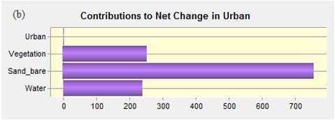
7 Urban Sprawl Prediction - Methodology Prediction based on Change Trend between 2000 and Idrisi Land change modeller featuring Markov chain modelling and Multi layer Neural Network Perception used. Done as hard and soft prediction. Road layer added as a sub model. Urban class would have increased by 2220 hectares with most of it as a result of a loss of 1192 hectares from the Sand (bare) class. 7

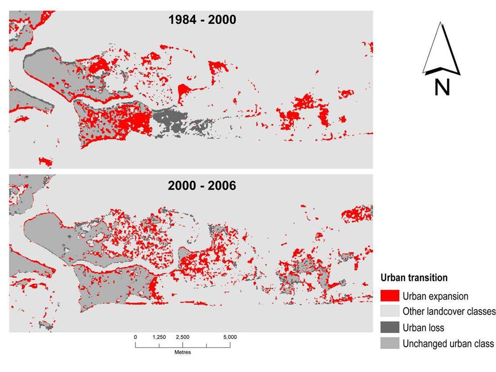
8 Discussion Transition from water to sand (bare) and urban class through (a) 1984, (b) 2000 & (c) 2006 Conclusion Urban sprawl occurred in a frog leaping pattern from and poly-nucleated pattern from Area prone to flooding Unpredictability of a natural disaster Changes in land use policies that could alter the trend of sprawl Unavailability of population data on ward and community levels. Non-availability of high resolution imagery 8
9 THANKS FOR LISTENING 9
Ajoke ONOJEGHUO and Alex ONOJEGHUO, Nigeria
 Mapping and Predicting Urban Sprawl Using Remote Sensing and Geographic Information System Techniques: A Case Study of Eti-Osa Local Government Area, Lagos, Nigeria Ajoke ONOJEGHUO and Alex ONOJEGHUO,
Investigation of the Effect of Transportation Network on Urban Growth by Using Satellite Images and Geographic Information Systems
 Presented at the FIG Congress 2018, May 6-11, 2018 in Istanbul, Turkey Investigation of the Effect of Transportation Network on Urban Growth by Using Satellite Images and Geographic Information Systems
APPLICATION OF LAND CHANGE MODELER FOR PREDICTION OF FUTURE LAND USE LAND COVER A CASE STUDY OF VIJAYAWADA CITY
 APPLICATION OF LAND CHANGE MODELER FOR PREDICTION OF FUTURE LAND USE LAND COVER A CASE STUDY OF VIJAYAWADA CITY K. Sundara Kumar 1, Dr. P. Udaya Bhaskar 2, Dr. K. Padmakumari 3 1 Research Scholar, 2,3
CHAPTER 2 REMOTE SENSING IN URBAN SPRAWL ANALYSIS
 9 CHAPTER 2 REMOTE SENSING IN URBAN SPRAWL ANALYSIS 2.1. REMOTE SENSING Remote sensing is the science of acquiring information about the Earth's surface without actually being in contact with it. This
INVESTIGATION LAND USE CHANGES IN MEGACITY ISTANBUL BETWEEN THE YEARS BY USING DIFFERENT TYPES OF SPATIAL DATA
 INVESTIGATION LAND USE CHANGES IN MEGACITY ISTANBUL BETWEEN THE YEARS 1903-2010 BY USING DIFFERENT TYPES OF SPATIAL DATA T. Murat Celikoyan, Elif Sertel, Dursun Zafer Seker, Sinasi Kaya, Uğur Alganci ITU,
Detection of Land Use and Land Cover Change around Eti-Osa Coastal Zone, Lagos State, Nigeria using Remote Sensing and GIS
 International Research Journal of Environment Sciences E-ISSN 2319 1414 Detection of Land Use and Land Cover Change around Eti-Osa Coastal Zone, Lagos State, Nigeria using Remote Sensing and GIS Abstract
URBAN CHANGE DETECTION OF LAHORE (PAKISTAN) USING A TIME SERIES OF SATELLITE IMAGES SINCE 1972
 USING A TIME SERIES OF SATELLITE IMAGES SINCE 1972") URBAN CHANGE DETECTION OF LAHORE (PAKISTAN) USING A TIME SERIES OF SATELLITE IMAGES SINCE 1972 Omar Riaz Department of Earth Sciences, University of Sargodha, Sargodha, PAKISTAN. omarriazpk@gmail.com ABSTRACT
URBAN CHANGE DETECTION OF LAHORE (PAKISTAN) USING A TIME SERIES OF SATELLITE IMAGES SINCE 1972 Omar Riaz Department of Earth Sciences, University of Sargodha, Sargodha, PAKISTAN. omarriazpk@gmail.com ABSTRACT
Progress and Land-Use Characteristics of Urban Sprawl in Busan Metropolitan City using Remote sensing and GIS
 Progress and Land-Use Characteristics of Urban Sprawl in Busan Metropolitan City using Remote sensing and GIS Homyung Park, Taekyung Baek, Yongeun Shin, Hungkwan Kim ABSTRACT Satellite image is very usefully
Analysis of Future Urban Growth Scenario of Damaturu Town in Yobe State, Nigeria
 Review Article Analysis of Future Urban Growth Scenario of Damaturu Town in Yobe State, Nigeria Muhammad Isma il* 1, Ibrahim Jaro Musa 1 and Ahmed Abubakar Jajere 2 1 Department of Geography, Ahmadu Bello
EFFECT OF ANCILLARY DATA ON THE PERFORMANCE OF LAND COVER CLASSIFICATION USING A NEURAL NETWORK MODEL. Duong Dang KHOI.
 EFFECT OF ANCILLARY DATA ON THE PERFORMANCE OF LAND COVER CLASSIFICATION USING A NEURAL NETWORK MODEL Duong Dang KHOI 1 10 Feb, 2011 Presentation contents 1. Introduction 2. Methods 3. Results 4. Discussion
Modeling Urban Land Cover Growth Dynamics Based on Land Change Modeler (LCM) Using Remote Sensing: A Case Study of Gurgaon, India
 Using Remote Sensing: A Case Study of Gurgaon, India") Advances in Computational Sciences and Technology ISSN 0973-6107 Volume 10, Number 10 (2017) pp. 2947-2961 Research India Publications http://www.ripublication.com Modeling Urban Land Cover Growth Dynamics
Advances in Computational Sciences and Technology ISSN 0973-6107 Volume 10, Number 10 (2017) pp. 2947-2961 Research India Publications http://www.ripublication.com Modeling Urban Land Cover Growth Dynamics
M.C.PALIWAL. Department of Civil Engineering NATIONAL INSTITUTE OF TECHNICAL TEACHERS TRAINING & RESEARCH, BHOPAL (M.P.), INDIA
, INDIA") INVESTIGATIONS ON THE ACCURACY ASPECTS IN THE LAND USE/LAND COVER MAPPING USING REMOTE SENSING SATELLITE IMAGERY By M.C.PALIWAL Department of Civil Engineering NATIONAL INSTITUTE OF TECHNICAL TEACHERS
INVESTIGATIONS ON THE ACCURACY ASPECTS IN THE LAND USE/LAND COVER MAPPING USING REMOTE SENSING SATELLITE IMAGERY By M.C.PALIWAL Department of Civil Engineering NATIONAL INSTITUTE OF TECHNICAL TEACHERS
Soil erosion susceptibility and coastal evolution: examples in southern New Caledonia
 Pacific Island Countries GIS /RS User Conference Soil erosion susceptibility and coastal evolution: examples in southern New Caledonia Pascal DUMAS et Olivier COHEN University of New-Caledonia (EA 4242/
Spatiotemporal Analysis of Noida, Greater Noida and Surrounding Areas (India) Using Remote Sensing and GIS Approaches
 Using Remote Sensing and GIS Approaches") Spatiotemporal Analysis of Noida, Greater Noida and Surrounding Areas (India) Using Remote Sensing and GIS Approaches Gopal Krishna* Indian Agricultural Research Institute, New Delhi, India ABSTRACT Spatiotemporal
Spatiotemporal Analysis of Noida, Greater Noida and Surrounding Areas (India) Using Remote Sensing and GIS Approaches Gopal Krishna* Indian Agricultural Research Institute, New Delhi, India ABSTRACT Spatiotemporal
THE REVISION OF 1:50000 TOPOGRAPHIC MAP OF ONITSHA METROPOLIS, ANAMBRA STATE, NIGERIA USING NIGERIASAT-1 IMAGERY
 I.J.E.M.S., VOL.5 (4) 2014: 235-240 ISSN 2229-600X THE REVISION OF 1:50000 TOPOGRAPHIC MAP OF ONITSHA METROPOLIS, ANAMBRA STATE, NIGERIA USING NIGERIASAT-1 IMAGERY 1* Ejikeme, J.O. 1 Igbokwe, J.I. 1 Igbokwe,
What is a compact city? How could it be measured?
 What is a compact city? How could it be measured? Madhu Singh Transport Planner Directorate of Urban Land Transport, Bangalore Guided By: Professor H. M. Shivanand Swamy CEPT University, Ahmedabad Cities
Urban Sprawl Prediction and Change Detection Analysis in and around Thiruvannamalai Town Using Remote Sensing and GIS
 Urban Sprawl Prediction and Change Detection Analysis in and around Thiruvannamalai Town Using Remote Sensing and GIS Hemanandhini.S 1, Suresh babu.s 2, Vinay.M.S 3 Department of Remote Sensing, Adhiyamaan
Quick Response Report #126 Hurricane Floyd Flood Mapping Integrating Landsat 7 TM Satellite Imagery and DEM Data
 Quick Response Report #126 Hurricane Floyd Flood Mapping Integrating Landsat 7 TM Satellite Imagery and DEM Data Jeffrey D. Colby Yong Wang Karen Mulcahy Department of Geography East Carolina University
Applications of GIS and Remote Sensing for Analysis of Urban Heat Island
 Chuanxin Zhu Professor Peter V. August Professor Yeqiao Wang NRS 509 December 15, 2016 Applications of GIS and Remote Sensing for Analysis of Urban Heat Island Since the last century, the global mean surface
Principals and Elements of Image Interpretation
 Principals and Elements of Image Interpretation 1 Fundamentals of Photographic Interpretation Observation and inference depend on interpreter s training, experience, bias, natural visual and analytical
STUDY OF NORMALIZED DIFFERENCE BUILT-UP (NDBI) INDEX IN AUTOMATICALLY MAPPING URBAN AREAS FROM LANDSAT TM IMAGERY
 INDEX IN AUTOMATICALLY MAPPING URBAN AREAS FROM LANDSAT TM IMAGERY") STUDY OF NORMALIZED DIFFERENCE BUILT-UP (NDBI) INDEX IN AUTOMATICALLY MAPPING URBAN AREAS FROM LANDSAT TM IMAGERY Dr. Hari Krishna Karanam Professor, Civil Engineering, Dadi Institute of Engineering &
STUDY OF NORMALIZED DIFFERENCE BUILT-UP (NDBI) INDEX IN AUTOMATICALLY MAPPING URBAN AREAS FROM LANDSAT TM IMAGERY Dr. Hari Krishna Karanam Professor, Civil Engineering, Dadi Institute of Engineering &
Proceeding Optical Remote Sensing Method for Detecting Urban Green Space as Indicator Serving City Sustainable Development
 Proceeding Optical Remote Sensing Method for Detecting Urban Green Space as Indicator Serving City Sustainable Development Tran Thi Van *, Nguyen Dang Huyen Tran, Ha Duong Xuan Bao, Dinh Thi Thanh Phuong,
A Logistic Regression Method for Urban growth modeling Case Study: Sanandaj City in IRAN
 A Logistic Regression Method for Urban growth modeling Case Study: Sanandaj City in IRAN Sassan Mohammady GIS MSc student, Dept. of Surveying and Geomatics Eng., College of Eng. University of Tehran, Tehran,
An Internet-based Agricultural Land Use Trends Visualization System (AgLuT)
") An Internet-based Agricultural Land Use Trends Visualization System (AgLuT) Second half yearly report 01-01-2001-06-30-2001 Prepared for Missouri Department of Natural Resources Missouri Department of
An Internet-based Agricultural Land Use Trends Visualization System (AgLuT) Second half yearly report 01-01-2001-06-30-2001 Prepared for Missouri Department of Natural Resources Missouri Department of
Lesson 4b Remote Sensing and geospatial analysis to integrate observations over larger scales
 Lesson 4b Remote Sensing and geospatial analysis to integrate observations over larger scales We have discussed static sensors, human-based (participatory) sensing, and mobile sensing Remote sensing: Satellite
Earth Science Chapter 9. Day 6 - Finish Capillary Action Lab - Quiz over Notes - Review Worksheets over Sections 9.2 and 9.3
 Earth Science Chapter 9 Day 1 Day 2 Day 3 Read Section 9.1 Surface Water Chapter 9 Term Sheet Notes over Section 9.1 Surface Water Section 9.1 Review Worksheets Quiz over Section 9.1 Notes Virtual Lab
Yaneev Golombek, GISP. Merrick/McLaughlin. ESRI International User. July 9, Engineering Architecture Design-Build Surveying GeoSpatial Solutions
 Yaneev Golombek, GISP GIS July Presentation 9, 2013 for Merrick/McLaughlin Conference Water ESRI International User July 9, 2013 Engineering Architecture Design-Build Surveying GeoSpatial Solutions Purpose
Which map shows the stream drainage pattern that most likely formed on the surface of this volcano? A) B)
 B)") 1. When snow cover on the land melts, the water will most likely become surface runoff if the land surface is A) frozen B) porous C) grass covered D) unconsolidated gravel Base your answers to questions
1. When snow cover on the land melts, the water will most likely become surface runoff if the land surface is A) frozen B) porous C) grass covered D) unconsolidated gravel Base your answers to questions
International Journal of Modern Trends in Engineering and Research e-issn No.: , Date: April, 2016
 International Journal of Modern Trends in Engineering and Research www.ijmter.com e-issn No.:2349-9745, Date: 28-30 April, 2016 Landslide Hazard Management Maps for Settlements in Yelwandi River Basin,
Urban Area Delineation Using Pattern Recognition Technique
 Cloud Publications International Journal of Advanced Remote Sensing and GIS 2018, Volume 7, Issue 1, pp. 2466-2470 ISSN 2320 0243, Crossref: 10.23953/cloud.ijarsg.333 Methodology Article Urban Area Delineation
Flood Vulnerability Mapping of Lagos Island and Eti-Osa Local Government Areas Using a Multi-Criteria Decision Making Approach
 Nigerian Journal of Environmental Sciences and Technology (NIJEST) www.nijest.com Vol 1, No. 2 July 2017, pp 42-53 Flood Vulnerability Mapping of Lagos Island and Eti-Osa Local Government Areas Using a
Use of Satellite Data to Study the Impact of Land-Cover/Land-Use Change in Madison County Alabama
 American Journal of Applied Sciences 6 (4): 656-660, 2009 ISSN 1546-9239 2009 Science Publications Use of Satellite Data to Study the Impact of Land-Cover/Land-Use Change in Madison County Alabama Tomas
Abstract: About the Author:
 REMOTE SENSING AND GIS IN LAND USE PLANNING Sathees kumar P 1, Nisha Radhakrishnan 2 1 1 Ph.D Research Scholar, Department of Civil Engineering, National Institute of Technology, Tiruchirappalli- 620015,
Land cover/land use mapping and cha Mongolian plateau using remote sens. Title. Author(s) Bagan, Hasi; Yamagata, Yoshiki. Citation Japan.
 Bagan, Hasi; Yamagata, Yoshiki. Citation Japan.") Title Land cover/land use mapping and cha Mongolian plateau using remote sens Author(s) Bagan, Hasi; Yamagata, Yoshiki International Symposium on "The Imp Citation Region Specific Systems". 6 Nove Japan.
Title Land cover/land use mapping and cha Mongolian plateau using remote sens Author(s) Bagan, Hasi; Yamagata, Yoshiki International Symposium on "The Imp Citation Region Specific Systems". 6 Nove Japan.
ESTIMATION OF LANDFORM CLASSIFICATION BASED ON LAND USE AND ITS CHANGE - Use of Object-based Classification and Altitude Data -
 ESTIMATION OF LANDFORM CLASSIFICATION BASED ON LAND USE AND ITS CHANGE - Use of Object-based Classification and Altitude Data - Shoichi NAKAI 1 and Jaegyu BAE 2 1 Professor, Chiba University, Chiba, Japan.
Soil Erosion Calculation using Remote Sensing and GIS in Río Grande de Arecibo Watershed, Puerto Rico
 Soil Erosion Calculation using Remote Sensing and GIS in Río Grande de Arecibo Watershed, Puerto Rico Alejandra M. Rojas González Department of Civil Engineering University of Puerto Rico at Mayaguez.
Landuse and Landcover change analysis in Selaiyur village, Tambaram taluk, Chennai
 Landuse and Landcover change analysis in Selaiyur village, Tambaram taluk, Chennai K. Ilayaraja Department of Civil Engineering BIST, Bharath University Selaiyur, Chennai 73 ABSTRACT The synoptic picture
Remote Sensing for Water Resource Management
 Remote Sensing for Water Resource Management Natascha Oppelt Kiel University Department of Geography Kiel University Ludewig-Meyn-Str 14 Department for Geography 24098 Kiel oppelt@geographie.uni-kiel.de
Land Cover Classification Mapping & its uses for Planning
 Land Cover Classification Mapping & its uses for Planning What is Land Cover Classification Mapping? Examples of an actual product Why use Land Cover Classification Mapping for planning? Possible uses
PREDICTION OF FUTURE LAND USE LAND COVER CHANGES OF VIJAYAWADA CITY USING REMOTE SENSING AND GIS
 PREDICTION OF FUTURE LAND USE LAND COVER CHANGES OF VIJAYAWADA CITY USING REMOTE SENSING AND GIS K. Sundara Kumar 1 *, N V A Sai Sankar Valasala 2, J V Subrahmanyam V 3, Mounika Mallampati 4 Kowsharajaha
APPLICATION OF REMOTE SENSING IN LAND USE CHANGE PATTERN IN DA NANG CITY, VIETNAM
 APPLICATION OF REMOTE SENSING IN LAND USE CHANGE PATTERN IN DA NANG CITY, VIETNAM Tran Thi An 1 and Vu Anh Tuan 2 1 Department of Geography - Danang University of Education 41 Le Duan, Danang, Vietnam
1. INTRODUCTION ACEPS
 Application of Remote Sensing and GIS techniques for exploring Construction Material from inaccessible terrains; case study in Eastern Province of Sri Lanka H.M.R. Premasiri, H.C.D.P. Colombage, D.Palamakumbure,
Optical Remote Sensing Method for Detecting Urban Green Space as Indicator Serving City Sustainable Development
 Proceedings Optical Remote Sensing Method for Detecting Urban Green Space as Indicator Serving City Sustainable Development Tran Thi Van *, Nguyen Dang Huyen Tran, Ha Duong Xuan Bao, Dinh Thi Thanh Phuong,
Need of Proper Development in Hilly Urban Areas to Avoid
 Need of Proper Development in Hilly Urban Areas to Avoid Landslide Hazard Dr. Arvind Phukan, P.E. Cosultant/Former Professor of Civil Engineering University of Alaska, Anchorage, USA RI District Governor
An Internet-based Agricultural Land Use Trends Visualization System (AgLuT)
") An Internet-based Agricultural Land Use Trends Visualization System (AgLuT) Prepared for Missouri Department of Natural Resources Missouri Department of Conservation 07-01-2000-12-31-2001 Submitted by
An Internet-based Agricultural Land Use Trends Visualization System (AgLuT) Prepared for Missouri Department of Natural Resources Missouri Department of Conservation 07-01-2000-12-31-2001 Submitted by
Annotated Bibliography. GIS/RS Assessment of Desertification
 David Hussong NRS 509 12/14/2017 Annotated Bibliography GIS/RS Assessment of Desertification Desertification is one of the greatest environmental challenges of the modern era. The United Nations Conference
Urban Expansion of the City Kolkata since last 25 years using Remote Sensing
 [ VOLUME 5 I ISSUE 2 I APRIL JUNE 2018] E ISSN 2348 1269, PRINT ISSN 2349-5138 Urban Expansion of the City Kolkata since last 25 years using Remote Sensing Soumita Banerjee Researcher, Faculty Council
Urban Growth Trend Analysis of Indore city ( ) Through Index Based Models Ankit Gupta 1*, Sarita Swain 2, Maya Kumari 3
 Through Index Based Models Ankit Gupta 1*, Sarita Swain 2, Maya Kumari 3") Urban Growth Trend Analysis of Indore city (2005 2014) Through Index Based Models Ankit Gupta 1*, Sarita Swain 2, Maya Kumari 3 1*, 2 Post Graduate Student, Amity Institute of Geo-Informatics & Remote
Urban Growth Trend Analysis of Indore city (2005 2014) Through Index Based Models Ankit Gupta 1*, Sarita Swain 2, Maya Kumari 3 1*, 2 Post Graduate Student, Amity Institute of Geo-Informatics & Remote
Carbon Sequestration Potential from Coastal Wetlands Restoration Sites
 Carbon Sequestration Potential from Coastal Wetlands Restoration Sites Insert then choose Picture select your picture. Right click your picture and Send to back. Paul Krause, Alyssa Beach Emily Cooper,
ESTIMATING LAND VALUE AND DISASTER RISK IN URBAN AREA IN YANGON, MYANMAR USING STEREO HIGH-RESOLUTION IMAGES AND MULTI-TEMPORAL LANDSAT IMAGES
 ESTIMATING LAND VALUE AND DISASTER RISK IN URBAN AREA IN YANGON, MYANMAR USING STEREO HIGH-RESOLUTION IMAGES AND MULTI-TEMPORAL LANDSAT IMAGES Tanakorn Sritarapipat 1 and Wataru Takeuchi 1 1 Institute
MAPPING LAND USE/ LAND COVER OF WEST GODAVARI DISTRICT USING NDVI TECHNIQUES AND GIS Anusha. B 1, Sridhar. P 2
 MAPPING LAND USE/ LAND COVER OF WEST GODAVARI DISTRICT USING NDVI TECHNIQUES AND GIS Anusha. B 1, Sridhar. P 2 1 M. Tech. Student, Department of Geoinformatics, SVECW, Bhimavaram, A.P, India 2 Assistant
(Refer Slide Time: 3:48)
") Introduction to Remote Sensing Dr. Arun K Saraf Department of Earth Sciences Indian Institute of Technology Roorkee Lecture 01 What is Satellite based Remote Sensing Hello, hello everyone this is Arun
Introduction to Remote Sensing Dr. Arun K Saraf Department of Earth Sciences Indian Institute of Technology Roorkee Lecture 01 What is Satellite based Remote Sensing Hello, hello everyone this is Arun
Application of Remote Sensing and GIS in Seismic Surveys in KG Basin
 P-318 Summary Application of Remote Sensing and GIS in Seismic Surveys in KG Basin M.Murali, K.Ramakrishna, U.K.Saha, G.Sarvesam ONGC Chennai Remote Sensing provides digital images of the Earth at specific
M.A./M.Sc. (Geography)
") M.A./M.Sc. (Geography) Note: Semester - I Geomorphology A total of eight questions will be se out the whole syllabus, at lest two from each carrying 10 marks each. Total attempt question are five. Unit-
M.A./M.Sc. (Geography) Note: Semester - I Geomorphology A total of eight questions will be se out the whole syllabus, at lest two from each carrying 10 marks each. Total attempt question are five. Unit-
Page 1 of 8 of Pontius and Li
 ESTIMATING THE LAND TRANSITION MATRIX BASED ON ERRONEOUS MAPS Robert Gilmore Pontius r 1 and Xiaoxiao Li 2 1 Clark University, Department of International Development, Community and Environment 2 Purdue
International Journal of Intellectual Advancements and Research in Engineering Computations
 ISSN:2348-2079 Volume-5 Issue-2 International Journal of Intellectual Advancements and Research in Engineering Computations Agricultural land investigation and change detection in Coimbatore district by
Spatial Planning Platform Meeting
 Spatial Planning Platform Meeting August 1 st 2018 Part II Session 1 Design and Implementation of National and Regional Planning for Inclusive Growth Spatial info from space based technologies RESTEC (Remote
GEOGRAPHY. Western Australian Certificate of Education Examination, Question/Answer Booklet. Stage 3
 Western Australian Certificate of Education Examination, 2015 Question/Answer Booklet GEOGRAPHY Stage 3 Please place your student identification label in this box Student Number: In figures In words Time
Urban land cover and land use extraction from Very High Resolution remote sensing imagery
 Urban land cover and land use extraction from Very High Resolution remote sensing imagery Mengmeng Li* 1, Alfred Stein 1, Wietske Bijker 1, Kirsten M.de Beurs 2 1 Faculty of Geo-Information Science and
SSRG International Journal of Geo informatics and Geological Science (SSRG-IJGGS) Volume 4 Issue 3 Sep to Dec 2017
 Volume 4 Issue 3 Sep to Dec 2017") Evaluation of the Relationship between Land Use/Land Cover Dynamics and Land Surface Temperature across the Niger Delta Region of Nigeria Aniekan Eyoh 1, Francis Okeke 2 Department of Geoinformatics &
Evaluation of the Relationship between Land Use/Land Cover Dynamics and Land Surface Temperature across the Niger Delta Region of Nigeria Aniekan Eyoh 1, Francis Okeke 2 Department of Geoinformatics &
Remote sensing technique to monitoring the risk of soil degradation using NDVI
 Remote sensing technique to monitoring the risk of soil degradation using NDVI Ahmed Asaad Zaeen Remote sensing Unit, College of Science, University of Baghdad, Iraq ahmed_a_z@scbaghdad.com Abstract. In
The Positional and Thematic Accuracy for Analysis of Multi-Temporal Satellite Images on Mangrove Areas
 The Positional and Thematic Accuracy for Analysis of Multi-Temporal Satellite Images on Mangrove Areas Paulo Rodrigo Zanin¹, Carlos Antonio O. Vieira² ¹Universidade Federal de Santa Catarina, Campus Universitário
Geo/SAT 2 AN URBAN HEAT ISLAND: WASHINGTON, D.C.
 Geo/SAT 2 AN URBAN HEAT ISLAND: WASHINGTON, D.C. Professor Paul R. Baumann Department of Geography State University of New York College at Oneonta Oneonta, New York 13820 USA COPYRIGHT 2008 Paul R. Baumann
VISUALIZATION URBAN SPATIAL GROWTH OF DESERT CITIES FROM SATELLITE IMAGERY: A PRELIMINARY STUDY
 CO-439 VISUALIZATION URBAN SPATIAL GROWTH OF DESERT CITIES FROM SATELLITE IMAGERY: A PRELIMINARY STUDY YANG X. Florida State University, TALLAHASSEE, FLORIDA, UNITED STATES ABSTRACT Desert cities, particularly
Existing NWS Flash Flood Guidance
 Introduction The Flash Flood Potential Index (FFPI) incorporates physiographic characteristics of an individual drainage basin to determine its hydrologic response. In flash flood situations, the hydrologic
AssessmentofUrbanHeatIslandUHIusingRemoteSensingandGIS
 Global Journal of HUMANSOCIAL SCIENCE: B Geography, GeoSciences, Environmental Science & Disaster Management Volume 16 Issue 2 Version 1.0 Type: Double Blind Peer Reviewed International Research Journal
Role of GIS and Remote Sensing to Environment Statistics
 United Nations Economic Commission for Africa Role of GIS and Remote Sensing to Environment Dozie Ezigbalike Data Management Coordinator A Definition Environment statistics are statistics that describe
CAN THO URBAN DEVELOPMENT AND RESILIENCE PROJECT
 CAN THO URBAN DEVELOPMENT AND RESILIENCE PROJECT 1 Phnom Penh Can Tho City HCM City EAST SEA 2 1 3 Highest Water Level WATER LEVEL RAISE IN CAN THO DURING LAST 40 YEARS 4 2 Land subsidence a threat that
Geospatial Information for Urban Sprawl Planning and Policies Implementation in Developing Country s NCR Region: A Study of NOIDA City, India
 Geospatial Information for Urban Sprawl Planning and Policies Implementation in Developing Country s NCR Region: A Study of NOIDA City, India Dr. Madan Mohan Assistant Professor & Principal Investigator,
SUPPORTING INFORMATION. Ecological restoration and its effects on the
 SUPPORTING INFORMATION Ecological restoration and its effects on the regional climate: the case in the source region of the Yellow River, China Zhouyuan Li, Xuehua Liu,* Tianlin Niu, De Kejia, Qingping
to low order streams, or percolated down to the water table (Yang et al., 2009). The prevalence of
. The prevalence of") Introduction The Effect of Land-cover Changes on Lag Time in the Banklick Creek Watershed, KY Katelyn Toebbe University of Louisville Department of Geography and Geosciences Urbanization in a watershed
Introduction The Effect of Land-cover Changes on Lag Time in the Banklick Creek Watershed, KY Katelyn Toebbe University of Louisville Department of Geography and Geosciences Urbanization in a watershed
Urban Tree Canopy Assessment Purcellville, Virginia
 GLOBAL ECOSYSTEM CENTER www.systemecology.org Urban Tree Canopy Assessment Purcellville, Virginia Table of Contents 1. Project Background 2. Project Goal 3. Assessment Procedure 4. Economic Benefits 5.
DETECTION AND ANALYSIS OF LAND-USE/LAND-COVER CHANGES IN NAY PYI TAW, MYANMAR USING SATELLITE REMOTE SENSING IMAGES
 DETECTION AND ANALYSIS OF LAND-USE/LAND-COVER CHANGES IN NAY PYI TAW, MYANMAR USING SATELLITE REMOTE SENSING IMAGES Kay Khaing Oo 1, Eiji Nawata 1, Kiyoshi Torii 2 and Ke-Sheng Cheng 3 1 Division of Environmental
Contents. Introduction Study area Data and Methodology Results Conclusions
 Modelling Spatial Changes in Suburban Areas of Istanbul Using Landsat 5 TM Data Şinasi Kaya(Assoc. Prof. Dr. ITU) Elif Sertel(Assoc. Prof. Dr. ITU) Dursun Z. Şeker(Prof. Dr. ITU) 1 Contents Introduction
Monitoring Vegetation Growth of Spectrally Landsat Satellite Imagery ETM+ 7 & TM 5 for Western Region of Iraq by Using Remote Sensing Techniques.
 Monitoring Vegetation Growth of Spectrally Landsat Satellite Imagery ETM+ 7 & TM 5 for Western Region of Iraq by Using Remote Sensing Techniques. Fouad K. Mashee, Ahmed A. Zaeen & Gheidaa S. Hadi Remote
RESULT. 4.1 Temporal Land use / Land Cover (LULC) inventory and Change Analysis
 inventory and Change Analysis") Chapter 4 RESULTS RESULT 4.1 Temporal Land use / Land Cover (LULC) inventory and Change Analysis The LULC maps of each study period were prepared by digital supervised classification of Landsat TM satellite
Chapter 4 RESULTS RESULT 4.1 Temporal Land use / Land Cover (LULC) inventory and Change Analysis The LULC maps of each study period were prepared by digital supervised classification of Landsat TM satellite
Urban Expansion. Urban Expansion: a global phenomenon with local causes? Stephen Sheppard Williams College
 Urban Expansion: a global phenomenon with local causes? Stephen Sheppard Williams College Presentation for World Bank, April 30, 2007 Presentations and papers available at http://www.williams.edu/economics/urbangrowth/homepage.htm
A Remote Sensing and GIS approach to trace the Densification in Residential Areas
 A Remote Sensing and GIS approach to trace the Densification in Residential Areas Valliappan AL Assistant Professor, School of Planning and Architecture, Vijayawada, India. Date:11/03/2015 What is Densification?
Remote sensing of sealed surfaces and its potential for monitoring and modeling of urban dynamics
 Remote sensing of sealed surfaces and its potential for monitoring and modeling of urban dynamics Frank Canters CGIS Research Group, Department of Geography Vrije Universiteit Brussel Herhaling titel van
Flash flood disaster in Bayangol district, Ulaanbaatar
 Flash flood disaster in Bayangol district, Ulaanbaatar Advanced Training Workshop on Reservoir Sedimentation Management 10-16 October 2007. IRTCES, Beijing China Janchivdorj.L, Institute of Geoecology,MAS
Land use land cover change detection: A case study: Khartoum state, Sudan,
 Global Journal of Environmental Science and Technology: ISSN-2360-7955, Vol. 3(1): pp 088-094, November, 2014. Copyright 2014 Spring Journals Full Length Research Paper Land use land cover change detection:
Residential Development Dynamics in Port Harcourt Metropolis: Implication for Efficient Urban Planning
 Residential Development Dynamics in Port Harcourt Metropolis: Implication for Efficient Urban Planning Collins H. Wizor (Ph.D) Department of Geography and Environmental Management, University of Port Harcourt,
Kimberly J. Mueller Risk Management Solutions, Newark, CA. Dr. Auguste Boissonade Risk Management Solutions, Newark, CA
 1.3 The Utility of Surface Roughness Datasets in the Modeling of United States Hurricane Property Losses Kimberly J. Mueller Risk Management Solutions, Newark, CA Dr. Auguste Boissonade Risk Management
AFRICAN URBANIZATION: SOME KEY ISSUES. Patricia Jones University of Oxford IGC Conference, Dar es Salaam 25 th February 2015
 AFRICAN URBANIZATION: SOME KEY ISSUES Patricia Jones University of Oxford IGC Conference, Dar es Salaam 25 th February 2015 Introduction New project on urbanization in Africa. World Bank funded but independent
Modeling Un-authorized Land Use Sprawl with Integrated Remote Sensing-GIS Technique and Cellular Automata
 Modeling Un-authorized Land Use Sprawl with Integrated Remote Sensing-GIS Technique and Cellular Automata Norzailawati Mohd. Noor and Mazlan Hashim Department of Remote Sensing, Faculty of Geoinformation
Physical Geography of the United States and Canada Chapter 5 A Land of Contrasts
 Physical Geography of the United States and Canada Chapter 5 A Land of Contrasts Land Area Together the U.S. and Canada cover more than 7 million square miles. In total area, Canada ranks 2 nd and the
SPATIO-TEMPORAL ASSESSMENT OF URBAN GROWTH IMPACT IN PUNE CITY USING REMOTELY SENSED DATA
 SPATIO-TEMPORAL ASSESSMENT OF URBAN GROWTH IMPACT IN PUNE CITY USING REMOTELY SENSED DATA Piyush Yadav, Shailesh Deshpande TATA Research Development and Design Centre, 54-B, Hadapsar Industrial Area, Pune-411013,
Using satellite images to calculate land use and land cover statistics
 Using satellite images to calculate land use and land cover statistics National Administrative Department of Statistics DANE Colombia April 2016 @DANE_Colombia /DANEColombia /DANEColombia Background (1)
Sub-pixel regional land cover mapping. with MERIS imagery
 Sub-pixel regional land cover mapping with MERIS imagery R. Zurita Milla, J.G.P.W. Clevers and M. E. Schaepman Centre for Geo-information Wageningen University 29th September 2005 Overview Land Cover MERIS
Land Use/Cover Changes & Modeling Urban Expansion of Nairobi City
 Land Use/Cover Changes & Modeling Urban Expansion of Nairobi City Overview Introduction Objectives Land use/cover changes Modeling with Cellular Automata Conclusions Introduction Urban land use/cover types
I. PRACTICAL GEOGRAPHY A. Maps. B. Scale and measurement. C. Map reading and interpretation; D. Interpretation of statistical data;
 TOPICS/CONTENTS/NOTES OBJECTIVES I. PRACTICAL GEOGRAPHY A. Maps Ai define and identify different types and uses of maps B. Scale and measurement distances, areas reduction and enlargement, directions,
GIS and Remote Sensing
 Spring School Land use and the vulnerability of socio-ecosystems to climate change: remote sensing and modelling techniques GIS and Remote Sensing Katerina Tzavella Project Researcher PhD candidate Technology
Developed in Consultation with Florida Educators
 Developed in Consultation with Florida Educators Table of Contents Next Generation Sunshine State Standards Correlation Chart... 7 Benchmarks Chapter 1 The Practice of Science...................... 11
Learning Objectives. Thermal Remote Sensing. Thermal = Emitted Infrared
 November 2014 lava flow on Kilauea (USGS Volcano Observatory) (http://hvo.wr.usgs.gov) Landsat-based thermal change of Nisyros Island (volcanic) Thermal Remote Sensing Distinguishing materials on the ground
Research Article A Quantitative Assessment of Surface Urban Heat Islands Using Satellite Multitemporal Data over Abeokuta, Nigeria
 International Atmospheric Sciences Volume 2016, Article ID 3170789, 6 pages http://dx.doi.org/10.1155/2016/3170789 Research Article A Quantitative Assessment of Surface Urban Heat Islands Using Satellite
Land Cover Modeling Report
 Land Cover Modeling Report Submitted to International Centre for Integrated Mountain Development (ICIMOD) Submitted by BUET-Japan Institute of Disaster Prevention and Urban Safety (BUET-JIDPUS); Bangladesh
USING NORMALIZED DIFFERENCE VEGETATION INDEX (NDVI) TO ASSESS VEGETATION COVER CHANGE IN MINING AREAS OF TUBAY, AGUSAN DEL NORTE
 TO ASSESS VEGETATION COVER CHANGE IN MINING AREAS OF TUBAY, AGUSAN DEL NORTE") USING NORMALIZED DIFFERENCE VEGETATION INDEX (NDVI) TO ASSESS VEGETATION COVER CHANGE IN MINING AREAS OF TUBAY, AGUSAN DEL NORTE Kendel P. Bolanio 1,2*, Meriam M. Santillan 1,2, Jojene R. Santillan 2,
USING NORMALIZED DIFFERENCE VEGETATION INDEX (NDVI) TO ASSESS VEGETATION COVER CHANGE IN MINING AREAS OF TUBAY, AGUSAN DEL NORTE Kendel P. Bolanio 1,2*, Meriam M. Santillan 1,2, Jojene R. Santillan 2,
Urban Expansion and Loss of Agricultural Land: A Remote Sensing Based Study of Shirpur City, Maharashtra
 Cloud Publications International Journal of Advanced Remote Sensing and GIS 2017, Volume 6, Issue 1, pp. 2097-2102 ISSN 2320 0243, Crossref: 10.23953/cloud.ijarsg.113 Research Article Open Access Urban
Comparison between Land Surface Temperature Retrieval Using Classification Based Emissivity and NDVI Based Emissivity
 Comparison between Land Surface Temperature Retrieval Using Classification Based Emissivity and NDVI Based Emissivity Isabel C. Perez Hoyos NOAA Crest, City College of New York, CUNY, 160 Convent Avenue,
Aniekan Eyoh 1* Department of Geoinformatics & Surveying, Faculty of Environmental Studies, University of Uyo, Nigeria
 Available online at http://euroasiapub.org/journals.php, pp. 53~62 Thomson Reuters Researcher ID: L-5236-2015 TEMPORAL APPRAISAL OF LAND SURFACE TEMPERATURE DYNAMICS ACROSS THE NINE STATES OF NIGER DELTA