Introduction to Remote sensing and applications
|
|
|
- Toby Phelps
- 6 years ago
- Views:
Transcription
1 Introduction to Remote sensing and applications Present by: Weerayuth Suanpaga อ.ว ระย ทธ สวนผกา 1 Contents Application of Remote Sensing 2 1
2 Advantage of RS Wide Coverage, Periodical Observation Variety of Observing Method Multi-resolution Multi-temporal Multi-spectral Global Environment Local Application Hydrology, Oceanography, Global Env. Study, CO2 3 Advantage of RS con t Agriculture, Forestry, Fisheries, Ecological Mapping Coastal zone management, Health Management, Energy Fire, Oil-spill, Volcano, Earthquake, Flood, Ice, Land use mapping, Cadastral Mapping, Topographic Map, Change Detection Military Use wisely by understanding advantage and limitation 4 2
3 Recent an example of RS application 0 Base map/back Ground map integrate with web-map server 1. Remote Sensing (LIDAR) for Management of Highway Assets for Safety 2. 3D Model of University of Melbourne Campus 3. NOAA/AVHRR - MODIS/TERRA Reception, Archiving and Distribution 4. Forest Fire Monitoring from NOAA AVHRR 5. MODIS for Flood Monitoring 6. Landuse Classes and its Multi-temporal Spectral Curves 7. planting pattern detection 8. Forest Fire Monitoring from NOAA AVHRR-Thailand 9. Defense Meteorological Satellite Program[DMSP] 10.Rice Growth Monitoring using RADAR Remote Sensing 5 Recent an example of RS application 11. RS for Drought Monitoring (using NOAA AVHRR) in Indonesia 12. Soil-Water-Atmosphere-Plant Model (SWAP) 13. Soil Erosion Monitoring 14. Tea yield Model 15. Mt. Mayon Volcano Comprehensive Disaster Prevention Master Plan 16. Flood Monitoring using JERS 17. Bangkok Urban Area Expansion 18. Micro Air Vehicles (MAV) 19. GPS 20. Debris flow 21. Landform Classification Method for Earthquake Damage Estimation 6 3


4 Base map Web map server 7 Remote Sensing (LIDAR) for Management of Highway Assets for Safety Iowa State University ~ University of Missouri-Columbia Lincoln University,University of Missouri-Kansas City University of Missouri-St. Louis,University of Northern Iowa 8 4
5 Main objective Utilize light detection and ranging (LIDAR) technology to obtain highway safety-related information. The safety needs of older drivers in terms of prolonged reaction times were taken into consideration. (1) identification of crashes that older drivers are morelikelytobeinvolvedin, (2) identification of highway geometric features that are important in such crashes (3) utilization of LIDAR data for obtaining information on the identified highway geometric features (4) assessment of the feasibility of using LIDAR data for such applications

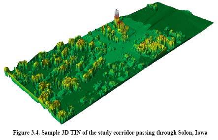
6


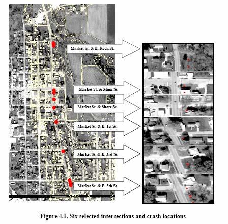
7 Sight triangles for Case B1, left turn from the minor road 13 The distance of the detected potential obstructions refers to the distance of the blue dots obtained during the line-of-sight analysis from the driver stopped on the minor road 14 7

8 summary -66 potential sight distance obstructions identified by the line-ofsight -The intersection with the highest crash frequency involving older drivers was correctly found to have obstructions located within the intersection sight triangles. -LIDAR data can be utilized for identifying potential sight distance obstructions at intersections. The safety of older drivers can be enhanced by locating and rectifying intersections with obstructions in sight triangles. $30,000 was spent
9
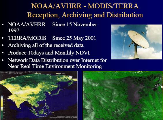
10 19 MODIS Installation 22 nd May 2001, AIT 20 10

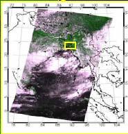
11 MODIS for Flood Monitoring


12 Planting pattern detection Historical TM image 1989 TM 8 Years Later 1997 TM Recent TM image for the TREES test site 125/61 on Sumatra The TM image from 18 August 97 shows new oil palm plantation areas, partly established by replacing old plantations, partly by conversion of forests. 23 Forest Fire Monitoring from NOAA AVHRR-Thailand 24 12


13 During the period of 4-16 July 2000, many fires were detected in Sumatra and Kalimantan of Indonesia


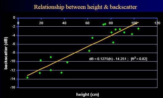
14 Rice Growth Monitoring using RADAR Remote Sensing 27 Rice Growth Monitoring Using Near Real Time RADARSAT Fine Beam SAR Data in Pathumthani Deployment sites of corner reflectors, plotted On ADEOS AVNIR image Canada Japan Thailand Within 8 hrs after reception 28 14

15

16
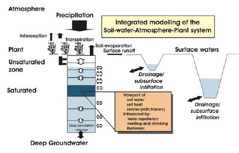
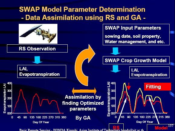
17 Soil-Water-Atmosphere-Plant Model (SWAP)
 February 1987:LandSat-TM August 1997: ADEOS-AVNIR Remote Sensing for Coastal Zone Management")

18 Soil moisture measurement 35 Remote Sensing for Coastal Zone Management Shrimp Farm extension in Chantaburi( ) February 1987:LandSat-TM August 1997: ADEOS-AVNIR Remote Sensing for Coastal Zone Management Shrimp Farm extension in Chantaburi( ) Extent of shrimp cultivation increase within ten years period in Chantaburi coastal area is clearly visible. Area shown within yellow square/circle in 1997 image are the area converted to shrimp farms


19 Soil Erosion Monitoring NDVI Map (Normalized Differential Vegetation Index ) Soil Erosion rate 0.91 mm/year Soil Erosion Map


20 Develop a model to find the correlation between LAI and NDVI derived from spectrophotometer readings


 Estimation of Lava Deposit")
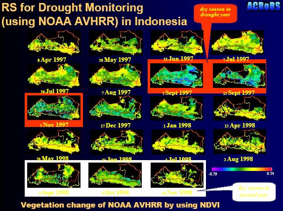
21 Mt. Mayon Volcano Comprehensive Disaster Prevention Master Plan GIS Data Development for Planner Historical River planform Change by lava, pyroclastic flow, lahar Sediment Production Estimation for river structure planning 41 Lava Deposit of Mr. Mayon (Pawa Burabod riverbed) Estimation of Lava Deposit Height using SAR Interferometry INSAR result Topographic difference 42 21


22 Flood Monitoring using JERS SAR 12 Scenes Mosaic 43 Bangkok Urban Area Expansion


23 Urban extent from 1988 to 1999 using classified Landsat TM 45 Military Micro Air Vehicles (MAV) 46 23

")

24 GPS 47 Global Navigation Satellite Systems (GNSS) NAVSTAR USA GLONASS Russians Galileo Europeans 48 24
25 How GPS works? Range from each satellite calculated range = time delay X speed of light Technique called trilateration is used to determine you position or fix Intersection of spheres At least 3 satellites required for 2D fix However, 4 satellites should always be used The 4 th satellite used to compensate for inaccurate clock in GPS receivers Yields much better accuracy and provides 3D fix 49 Three SV ranges known 20,000 Km radius 22,000 Km radius Located at one of these 2 points. However, one point can easily be eliminated because it is either not on earth or moving at impossible rate of speed. 21,000 Km radius 50 25


26 Debris flow
27 Characteristics of R/S Wide Area global 1 scene 185*185km Quick 1 scene in 25sec Multi Temporal Every 16days Multi Spectral 8 bands Computer fit digital data - algorithm Map Projection UTM Example of Landsat 7 Satellite 53 Trade-off in Performance Spatial Resolution ( 1 observation unit on ground surface ) 30 m - 250km - 1km Temporal Resolution 16 days - 1day Spectral Resolution 7 channel vs 36 channel Observation Extent 185 km vs 2,300km S/N 8bits vs 10bits cost 1 scene 800US$ vs Free ( Broadcast ) 54 27
28 Advantage of RS Wide Coverage, Periodical Observation Variety of Observing Method Multi-resolution Multi-temporal Multi-spectral Global Environment Local Application Application Field Hydrology, Oceanography, Global Env. Study, CO2 Agriculture, Forestry, Fisheries, Ecological Mapping Coastal zone management, Health Management, Energy Fire, Oil-spill, Volcano, Earthquake, Flood, Ice, Land use mapping, Cadastral Mapping, Topographic Map, Change Detection Military Use wisely by understanding advantage and limitation 55 Limitation Low resolution Spatial Resolution Geo-location Data Handling Format: Local format Not enough Support from commercial software Projection 10bits data Difficulty in implementing local processing system Off-Nadir Observation Strong Effect of Bi-directional Reflectance BRDF High resolution Limitation of High-Reso Re-Visit Time 2 18days Cloud Cover Project planning Spectral Information Panchromatic to several bands only S/N Normally 6-8 bits Geo-location Distortion by topographic effect ( edge, highmountains) Off-Nadir Observation Coverage Several 10km 180km Cost Usually not free Sometimes expensive Super-high reso: ExpensiveSatellite Geometry Model: sometimes not open 56 28
29 Advantage :High and low resolution satellite Low resolution High Multi-Temporal Global Coverage Multi-Spectral Information Cloud Free Products Free Data, Free Software Series of algorithm for estimating environmental physical parameter. Local Receiving is feasible Free for receiving S band X band 100,000 US$-500,000US$ Hyper-Spectral Information e.g. 36 ch. Improved Resolution to 250m-500m Value Added Data Product, e.g. MODIS Network Data Distribution, AIT, UT, NASA Near Real time Monitoring, several hrs. High resolution -Advantage of High-Resolution Easy for interpretation - Good products line Systematic High-Precision - Good search/ordering system Commercial - Distributor Easy Handling Common formats Supported by various software Good combination with 1/100,00 1/50,000 maps Plenty of Application examples Improved resolution Multi- Spectral 57 Selection between: Low to Moderate Resolution Optical Satellites Low to Moderate resolution satellite data with their resolution of 250 to 1km is important to regional to global scale environmental monitoring. The advantage of these data are their frequent observation which covers the whole globe within one day. Some satellites have morning and afternoon satellites which gives us twice a day observation. In spite of its low spatial resolution, its high multi-temporal capability, high-sensitivity sensors, multi-spectral capability provide us with excellent data and application opportunity. Also, recent effort to provide the data in systematic way such as distribution on internet, producing value added data has been enhancing its usability
30 RADAR RS SAR( Synthetic Aperture Radar ) All weather capability Construction of short-interval time series through cloud cover crop-growth cycle Ground Roughness (flat or rigid) Moisture : -soilmoisture Structure : - vegetation height 59 Reference: Assoc.Prof.Dr.HONDA Kiyoshi, Lecture Note.School of Engineering and Technology,AIT Thailand. Suggested Web Sites: AUSLIG ( Space Imaging ( Australian Bureau of Meteorology ( JPL Radar Site ( Australian geological Survey Organization (
31 END 61 31
Introduction to Remote sensing and
 Introduction to Remote sensing and applications Dr.Weerakaset Suanpaga Contents Application of Remote Sensing D.Eng(RS&GIS) 1 2 Advantage of RS Wide Coverage, Periodical Observation Variety of Observing
RADAR Remote Sensing Application Examples
 RADAR Remote Sensing Application Examples! All-weather capability: Microwave penetrates clouds! Construction of short-interval time series through cloud cover - crop-growth cycle! Roughness - Land cover,
Remote Sensing. RS Study in RS&GIS FoS
 AT 76.03 Remote Sensing Prof. Kiyoshi Honda, Chubu University Dr. Nobuya Watanabe, Chubu University Supported by Japanese Government s Short Time Visiting Faculty Scheme RS&GIS School of Engineering and
Physical Geography: Patterns, Processes, and Interactions, Grade 11, University/College Expectations
 Geographic Foundations: Space and Systems SSV.01 explain major theories of the origin and internal structure of the earth; Page 1 SSV.02 demonstrate an understanding of the principal features of the earth
GNSS and Its Applications in the context of Bangladesh
 GNSS and Its Applications in the context of Bangladesh Mozammel Haque Sarker Principal Scientific Officer mhsarker2@yahoo.com Bangladesh Space Research and Remote Sensing Organization (SPARRSO) website:
GI Technology for Disaster Management
 GI Technology for Disaster Management 17 th ICC on the Regional Space Applications Programme for Sustainable Development (RESAP) 26 th Nov 2013 Bangkok Thailand Period and time of seasonal in thailand
ZRCSAZU. Remote sensing and Earth observation data at ZRC SAZU. dr. Tatjana Veljanovski Atrij ZRC Ljubljana
 ZRCSAZU Remote sensing and Earth observation data at ZRC SAZU dr. Tatjana Veljanovski 2016-06-08 Atrij ZRC Ljubljana Remote Sensing Department Remote Sensing Department 20 years of experience application,
European Space Agency
 Guidelines - Guidelines how/when to interact during the WebEx session: - Due to the number of attendees, please keep always your webcam and microphone switched-off - You can use anytime the chat to all
Application Status and Prospect of Microwave Remote Sensing
 2017 International Conference on Computing, Communications and Automation(I3CA 2017) Application Status and Prospect of Microwave Remote Sensing Cheng Lele, Yan Xinsui, Zhou Mengqiu, Zhou Yongqin, Wang
ESM 186 Environmental Remote Sensing and ESM 186 Lab Syllabus Winter 2012
 ESM 186 Environmental Remote Sensing and ESM 186 Lab Syllabus Winter 2012 Instructor: Susan Ustin (slustin@ucdavis.edu) Phone: 752-0621 Office: 233 Veihmeyer Hall and 115A, the Barn Office Hours: Tuesday
DAMAGE DETECTION OF THE 2008 SICHUAN, CHINA EARTHQUAKE FROM ALOS OPTICAL IMAGES
 DAMAGE DETECTION OF THE 2008 SICHUAN, CHINA EARTHQUAKE FROM ALOS OPTICAL IMAGES Wen Liu, Fumio Yamazaki Department of Urban Environment Systems, Graduate School of Engineering, Chiba University, 1-33,
A MODEL FOR RISES AND DOWNS OF THE GREATEST LAKE ON EARTH
 A MODEL FOR RISES AND DOWNS OF THE GREATEST LAKE ON EARTH Parviz Tarikhi Iranian Remote Sensing Center, Iran May 2005 1 Figure 1: West of Novshahr in the Iranian coast of Caspian; the dam constructed to
Country Report. KAZAKHSTAN DAN of SENTINEL ASIA INITIATIVE
 Country Report KAZAKHSTAN DAN of SENTINEL ASIA INITIATIVE Putrajaya, 2011 LAND RESOURCES OF KAZAKHSTAN Area 2,72 mln km 2 Population 16 Mln Land use Area Mln. ha % Territory of Republic 272,4 Agriculture
Potential and Accuracy of Digital Landscape Analysis based on high resolution remote sensing data
 'Spatial Information for Sustainable Management of Urban Areas' Mainz, 2-4 February 2009, Germany Potential and Accuracy of Digital Landscape Analysis based on high resolution remote sensing data Dr. Matthias
REVIEW MAPWORK EXAM QUESTIONS 31 JULY 2014
 REVIEW MAPWORK EXAM QUESTIONS 31 JULY 2014 Lesson Description In this lesson we: Focus on key concepts and exam questions relating to GIS. Question 1 Test Yourself The most important component of a GIS
Drought Estimation Maps by Means of Multidate Landsat Fused Images
 Remote Sensing for Science, Education, Rainer Reuter (Editor) and Natural and Cultural Heritage EARSeL, 2010 Drought Estimation Maps by Means of Multidate Landsat Fused Images Diego RENZA, Estíbaliz MARTINEZ,
GEOG Lecture 8. Orbits, scale and trade-offs
 Environmental Remote Sensing GEOG 2021 Lecture 8 Orbits, scale and trade-offs Orbits revisit Orbits geostationary (36 000 km altitude) polar orbiting (200-1000 km altitude) Orbits revisit Orbits geostationary
GIS and Remote Sensing
 Spring School Land use and the vulnerability of socio-ecosystems to climate change: remote sensing and modelling techniques GIS and Remote Sensing Katerina Tzavella Project Researcher PhD candidate Technology
Themes for Geomatics Conference. Geodesy Themes
 Themes for Geomatics Conference Geodesy Themes Geodynamics o Modeling the Deformation of the Earth s Crust o Recent Advances in Geometric Approaches to Deformation Analysis o Monitoring Systems (Sensors
THREE DIMENSIONAL DETECTION OF VOLCANIC DEPOSIT ON MOUNT MAYON USING SAR INTERFEROMETRY
 ABSTRACT THREE DIMENSIONAL DETECTION OF VOLCANIC DEPOSIT ON MOUNT MAYON USING SAR INTERFEROMETRY Francis X.J. Canisius, Kiyoshi Honda, Mitsuharu Tokunaga and Shunji Murai Space Technology Application and
This module presents remotely sensed assessment (choice of sensors and resolutions; airborne or ground based sensors; ground truthing)
") This module presents remotely sensed assessment (choice of sensors and resolutions; airborne or ground based sensors; ground truthing) 1 In this presentation you will be introduced to approaches for using
This module presents remotely sensed assessment (choice of sensors and resolutions; airborne or ground based sensors; ground truthing) 1 In this presentation you will be introduced to approaches for using
Deforestation and Degradation in Central and Southern Africa. Project Title: "Deforestation and Degradation in Central and Southern Africa"
 Deforestation and Degradation in Central and Southern Africa Project Title: "Deforestation and Degradation in Central and Southern Africa" Description: An integrated land degradation and deforestation
Data Fusion and Multi-Resolution Data
 Data Fusion and Multi-Resolution Data Nature.com www.museevirtuel-virtualmuseum.ca www.srs.fs.usda.gov Meredith Gartner 3/7/14 Data fusion and multi-resolution data Dark and Bram MAUP and raster data Hilker
Applications of GIS and Remote Sensing for Analysis of Urban Heat Island
 Chuanxin Zhu Professor Peter V. August Professor Yeqiao Wang NRS 509 December 15, 2016 Applications of GIS and Remote Sensing for Analysis of Urban Heat Island Since the last century, the global mean surface
Introduction of PALSAR and PALSAR Data Application Plan
 Introduction of PALSAR and PALSAR Data Application Plan September 19 th, 2006 Tomonori Deguchi deguchi@ersdac.or.jp Earth Remote Sensing Data Analysis Center (ERSDAC) http://www.ersdac.or.jp Contents 1.
Sources of Imagery and GIS Data Layers (Last updated October 2005)
") Sources of Imagery and GIS Data Layers (Last updated October 2005) The question of where to find data is one often asked by beginners in precision agriculture and other geospatial projects. The following
Sources of Imagery and GIS Data Layers (Last updated October 2005) The question of where to find data is one often asked by beginners in precision agriculture and other geospatial projects. The following
COURSE OUTLINE. GEO 101 Geography 3 Course Number Course Title Credits. Reference Liberal Arts Division Book List
 MERCER COUNTY COMMUNITY COLLEGE LIBERAL ARTS DIVISION COURSE OUTLINE GEO 101 Geography 3 Course Number Course Title Credits Required Materials: Catalog Description: Reference Liberal Arts Division Book
DROUGHT RISK EVALUATION USING REMOTE SENSING AND GIS : A CASE STUDY IN LOP BURI PROVINCE
 DROUGHT RISK EVALUATION USING REMOTE SENSING AND GIS : A CASE STUDY IN LOP BURI PROVINCE K. Prathumchai, Kiyoshi Honda, Kaew Nualchawee Asian Centre for Research on Remote Sensing STAR Program, Asian Institute
!"#$%&' #(!()* +,-'.,$ &%!/(%)!'%
* +,-'.,$ &%!/(%)!'%") !"#$%&' #(!()* +,-'.,$ &%!/(%)!'% /01234 5013673 Iranian Remote Sensing Center (IRSC) No. 22, 14 th Street, Saadat-Abad Tehran 19979, Iran Tel: +98 21 2063207 Fax: +98 21 2064474 E-mail: irsc@www.dci.co.ir
!"#$%&' #(!()* +,-'.,$ &%!/(%)!'% /01234 5013673 Iranian Remote Sensing Center (IRSC) No. 22, 14 th Street, Saadat-Abad Tehran 19979, Iran Tel: +98 21 2063207 Fax: +98 21 2064474 E-mail: irsc@www.dci.co.ir
Fundamentals of Remote Sensing
 Division of Spatial Information Science Graduate School Life and Environment Sciences University of Tsukuba Fundamentals of Remote Sensing Prof. Dr. Yuji Murayama Surantha Dassanayake 10/6/2010 1 Fundamentals
Real Time Subsidence Monitoring Techniques in Undercity Mining and a Case Study: Zonguldak Undercity Applications-Turkey
 Real Time Subsidence Monitoring Techniques in Undercity Mining and a Case Study: Zonguldak Undercity Hakan AKCIN, Hakan S. KUTOGLU, Turkey Keywords: Undercity mining, subsidence, PALSAR, RADARSAT, GNSS.
(Refer Slide Time: 3:48)
") Introduction to Remote Sensing Dr. Arun K Saraf Department of Earth Sciences Indian Institute of Technology Roorkee Lecture 01 What is Satellite based Remote Sensing Hello, hello everyone this is Arun
Introduction to Remote Sensing Dr. Arun K Saraf Department of Earth Sciences Indian Institute of Technology Roorkee Lecture 01 What is Satellite based Remote Sensing Hello, hello everyone this is Arun
RS / GIS for Disaster Management. Some Important Definitions. Classifications of Natural Disasters. Disasters W/Some Human Influence
 RS / GIS for Disaster Management A Basic Introduction to Natural Disasters Using Remote Sensing & GIS ~~~~~~~~~~ Rev. Ronald J. Wasowski, C.S.C. Associate Professor of Environmental Science University
Annex VI-1. Draft National Report on Ocean Remote Sensing in China. (Reviewed by the Second Meeting of NOWPAP WG4)
") UNEP/NOWPAP/CEARAC/WG4 2/9 Page1 Draft National Report on Ocean Remote Sensing in China (Reviewed by the Second Meeting of NOWPAP WG4) UNEP/NOWPAP/CEARAC/WG4 2/9 Page1 1. Status of RS utilization in marine
UNEP/NOWPAP/CEARAC/WG4 2/9 Page1 Draft National Report on Ocean Remote Sensing in China (Reviewed by the Second Meeting of NOWPAP WG4) UNEP/NOWPAP/CEARAC/WG4 2/9 Page1 1. Status of RS utilization in marine
Weather Satellite Data Applications for Monitoring and Warning Hazard at BMKG
 The 5th Meeting of the Coordinating Group of the RA II WIGOS Satellite Project 21 October 2017, Vladivostok city, Russky Island, Russia Far Eastern Federal University Weather Satellite Data Applications
2013 Esri Europe, Middle East and Africa User Conference October 23-25, 2013 Munich, Germany
 2013 Esri Europe, Middle East and Africa User Conference October 23-25, 2013 Munich, Germany Environmental and Disaster Management System in the Valles Altos Region in Carabobo / NW-Venezuela Prof.Dr.habil.Barbara
The use of satellite images to forecast agricultural production
 The use of satellite images to forecast agricultural production Artur Łączyński Central Statistical Office, Agriculture Department Niepodległości 208 Warsaw, Poland E-mail a.laczynski@stat.gov.pl DOI:
EO Information Services in support of Satellite Tools for Building Flood Defence Systems in Guyana
 EO Information Services in support of Satellite Tools for Building Flood Defence Systems in Guyana F. N. Koudogbo and A. Arnaud Altamira Information J. Leen, Eurosense World Bank HQ, Washington DC Date
Satellite Remote Sensing for Ocean
 Satellite Remote Sensing for Ocean August 17, 2017 Masatoshi Kamei RESTEC All rights reserved RESTEC 2015 Contents 1. About RESTEC and Remote Sensing 2. Example of Remote Sensing Technology 3. Remote Sensing
Challenges for the operational assimilation of satellite image data in agrometeorological models
 Challenges for the operational assimilation of satellite image data in agrometeorological models Mark Danson Centre for Environmental Systems Research, University of Salford, UK 0 Objectives The main objective
SURVEYING Chapter 1 Introduction
 PHILADELPHIA UNIVERSITY Faculty of Engineering. Department of Civil Engineering. SURVEYING Chapter 1 Introduction Surveying : the art or science of measuring and representing natural and artificial features
Earth Observation Satellites Dawn of Application Specific Satellite Data. Date: 26 July 2017
 Earth Observation Satellites Dawn of Application Specific Satellite Data Date: 26 July 2017 Introducing a World of New Possibilities Satellite imagery is a critical fountain of information on al levels
Interferometric Synthetic Aperture Radar (InSAR) and GGOS. Andrea Donnellan NASA/JPL February 21, 2007
 and GGOS. Andrea Donnellan NASA/JPL February 21, 2007") Interferometric Synthetic Aperture Radar (InSAR) and GGOS Andrea Donnellan NASA/JPL February 21, 2007 Sources for Science Objectives Fourth component of EarthScope Involvement: NSF, NASA, USGS, Universities
Interferometric Synthetic Aperture Radar (InSAR) and GGOS Andrea Donnellan NASA/JPL February 21, 2007 Sources for Science Objectives Fourth component of EarthScope Involvement: NSF, NASA, USGS, Universities
Historical background
 Space Technology for Disaster Management in Sri Lanka: Country profile, national perspectives & vision. Professor Ranjith Premalal De Silva Vice Chancellor Uva Wellassa University of Sri Lanka October
Last date for submission of Assignments is Title of the course: PGD-GARD - II Semester. Third Batch (2018) - ASSIGNMENT
 - ASSIGNMENT") Last date for submission of Assignments is 31-12-2018 Title of the course: PGD-GARD - II Semester Third Batch (2018) - ASSIGNMENT Course No. GARD-507: Course Title: Remote Sensing -II Total Marks: 30 Note:
Last date for submission of Assignments is 31-12-2018 Title of the course: PGD-GARD - II Semester Third Batch (2018) - ASSIGNMENT Course No. GARD-507: Course Title: Remote Sensing -II Total Marks: 30 Note:
Advanced Image Analysis in Disaster Response
 Advanced Image Analysis in Disaster Response Creating Geographic Knowledge Thomas Harris ITT The information contained in this document pertains to software products and services that are subject to the
Assessing Drought in Agricultural Area of central U.S. with the MODIS sensor
 Assessing Drought in Agricultural Area of central U.S. with the MODIS sensor Di Wu George Mason University Oct 17 th, 2012 Introduction: Drought is one of the major natural hazards which has devastating
Introduction to Satellite Derived Vegetation Indices
 Introduction to the Use of Geospatial Information Technology for Drought Risk Management 13-17 November, 2017 Tonle Bassac II Restaurant, Phnom Penh, Cambodia Introduction to Satellite Derived Vegetation
Remote sensing technologies for infrastructure management: Russian experience
 icccbe 2010 Nottingham University Press Proceedings of the International Conference on Computing in Civil and Building Engineering W Tizani (Editor) Remote sensing technologies for infrastructure management:
Remote Sensing and GIS for Archaeological Applications in Thailand : Case Studies of Royal Road. Surat Lertlum
 Remote Sensing and GIS for Archaeological Applications in Thailand : Case Studies of Royal Road from Angkor to Phimai,, the Study at Sukhothai World Heritage Site, and Ayuttaya s World Heritage Site Surat
Geomatics: Geotechnologies in Action, Grade 12, University/College Expectations
 Geographic Foundations: Space and Systems SSV.01 explain how the earth is modelled for scientific and mapping purposes; SSV.02 demonstrate an understanding of basic spatial concepts; Page 1 SSV.03 explain
Mapping Coastal Change Using LiDAR and Multispectral Imagery
 Mapping Coastal Change Using LiDAR and Multispectral Imagery Contributor: Patrick Collins, Technical Solutions Engineer Presented by TABLE OF CONTENTS Introduction... 1 Coastal Change... 1 Mapping Coastal
Remote Sensing Based Inversion of Gap Fraction for Determination of Leaf Area Index. Alemu Gonsamo 1 and Petri Pellikka 1
 Remote Sensing Based Inversion of Gap Fraction for Determination of Leaf Area Index Alemu Gonsamo and Petri Pellikka Department of Geography, University of Helsinki, P.O. Box, FIN- Helsinki, Finland; +-()--;
A Facility for Producing Consistent Remotely Sensed Biophysical Data Products of Australia
 TERRESTRIAL ECOSYSTEM RESEARCH NETWORK - AusCover - A Facility for Producing Consistent Remotely Sensed Biophysical Data Products of Australia June, 2011 Mervyn Lynch Professor of Remote Sensing Curtin
ESTIMATION OF LANDFORM CLASSIFICATION BASED ON LAND USE AND ITS CHANGE - Use of Object-based Classification and Altitude Data -
 ESTIMATION OF LANDFORM CLASSIFICATION BASED ON LAND USE AND ITS CHANGE - Use of Object-based Classification and Altitude Data - Shoichi NAKAI 1 and Jaegyu BAE 2 1 Professor, Chiba University, Chiba, Japan.
History & Scope of Remote Sensing FOUNDATIONS
 History & Scope of Remote Sensing FOUNDATIONS Lecture Overview Introduction Overview of visual information Power of imagery Definition What is remote sensing? Definition standard for class History of Remote
Abdolreza Ansari Amoli. Remote Sensing Department Iranian Space Agency
 Risk Assessment and Mapping Using Earth Observation Data In Iran Abdolreza Ansari Amoli Remote Sensing & GIS Expert Remote Sensing Department Iranian Space Agency Different Types of Disasters in Iran Epidemic
1 Introduction: 2 Data Processing:
 Darren Janzen University of Northern British Columbia Student Number 230001222 Major: Forestry Minor: GIS/Remote Sensing Produced for: Geography 413 (Advanced GIS) Fall Semester Creation Date: November
USE OF INTERFEROMETRIC SATELLITE SAR FOR EARTHQUAKE DAMAGE DETECTION ABSTRACT
 USE OF INTERFEROMETRIC SATELLITE SAR FOR EARTHQUAKE DAMAGE DETECTION Masashi Matsuoka 1 and Fumio Yamazaki 2 ABSTRACT Synthetic Aperture Radar (SAR) is one of the most promising remote sensing technologies
NASA s Airborne Visible/Infrared Imaging Spectrometer (AVIRIS) AVIRIS: PEARL HARBOR, HAWAII
 AVIRIS: PEARL HARBOR, HAWAII") AVIRIS: PEARL HARBOR, HAWAII 000412 NASA s Airborne Visible/Infrared Imaging Spectrometer (AVIRIS) LCLUC Update Robert O. Green (Tom Chrien, presenting) Jet Propulsion Laboratory Overview Objective & Approach
AVIRIS: PEARL HARBOR, HAWAII 000412 NASA s Airborne Visible/Infrared Imaging Spectrometer (AVIRIS) LCLUC Update Robert O. Green (Tom Chrien, presenting) Jet Propulsion Laboratory Overview Objective & Approach
Extent. Level 1 and 2. October 2017
 Extent Level 1 and 2 October 2017 Overview: Extent account 1. Learning objectives 2. Review of Level 0 (5m) 3. Level 1 (Compilers): Concepts (15m) Group exercise and discussion (15m) 4. Level 2 (Data Providers)
Government GIS and its Application for Decision Support
 Government GIS and its Application for Decision Support Zhang Qingpu (Chinese Academy of Surveying and Mapping, Email: zhangqp@casm.ac.cn) Abstract: Application of GIS in government agencies is called
The Wide Dynamic Range Vegetation Index and its Potential Utility for Gap Analysis
 Summary StatMod provides an easy-to-use and inexpensive tool for spatially applying the classification rules generated from the CT algorithm in S-PLUS. While the focus of this article was to use StatMod
Making a case for full-polarimetric radar remote sensing
 Making a case for full-polarimetric radar remote sensing Jeremy Nicoll Alaska Satellite Facility, University of Alaska Fairbanks 1 Polarization States of a Coherent Plane Wave electric field vector vertically
New Era of Global Monitoring by ALOS-2: Advanced Land Observing Satellite-2 DAICHI-2 Yuko Suzuki
 New Era of Global Monitoring by ALOS-2: Advanced Land Observing Satellite-2 DAICHI-2 Yuko Suzuki International Relations and Research Department Japan Aerospace Exploration Agency (JAXA) 1 Dawning Era
GEOGRAPHY (029) CLASS XI ( ) Part A: Fundamentals of Physical Geography. Map and Diagram 5. Part B India-Physical Environment 35 Marks
 CLASS XI ( ) Part A: Fundamentals of Physical Geography. Map and Diagram 5. Part B India-Physical Environment 35 Marks") GEOGRAPHY (029) CLASS XI (207-8) One Theory Paper 70 Marks 3 Hours Part A Fundamentals of Physical Geography 35 Marks Unit-: Geography as a discipline Unit-3: Landforms Unit-4: Climate Unit-5: Water (Oceans)
GEOGRAPHY (029) CLASS XI (207-8) One Theory Paper 70 Marks 3 Hours Part A Fundamentals of Physical Geography 35 Marks Unit-: Geography as a discipline Unit-3: Landforms Unit-4: Climate Unit-5: Water (Oceans)
Contribution to global Earth observation from satellites
 Contribution to global Earth observation from satellites - JAXA s Earth Observation strategy - April 16, 2008 Makoto Kajii Japan Aerospace Exploration Agency Earth Observation Summits and GEOSS 1 st EO
Vegetation Change Detection of Central part of Nepal using Landsat TM
 Vegetation Change Detection of Central part of Nepal using Landsat TM Kalpana G. Bastakoti Department of Geography, University of Calgary, kalpanagb@gmail.com Abstract This paper presents a study of detecting
FLOOD ANALYSIS USING SATELLITE DATA AND GEOMORPHOLOGICAL SURVEY MAP SHOWING CLASSIFICATION OF FLOOD-INUNDATED AREAS
 FLOOD ANALYSIS USING SATELLITE DATA AND GEOMORPHOLOGICAL SURVEY MAP SHOWING CLASSIFICATION OF FLOOD-INUNDATED AREAS Yasuharu YAMADA* *Japan International Research Center for Agricultural Sciences (JIRCAS),
Land Surface Temperature Measurements From the Split Window Channels of the NOAA 7 Advanced Very High Resolution Radiometer John C.
 Land Surface Temperature Measurements From the Split Window Channels of the NOAA 7 Advanced Very High Resolution Radiometer John C. Price Published in the Journal of Geophysical Research, 1984 Presented
ACCURACY ASSESSMENT OF ASTER GLOBAL DEM OVER TURKEY
 ACCURACY ASSESSMENT OF ASTER GLOBAL DEM OVER TURKEY E. Sertel a a ITU, Civil Engineering Faculty, Geomatic Engineering Department, 34469 Maslak Istanbul, Turkey sertele@itu.edu.tr Commission IV, WG IV/6
Debris flow: categories, characteristics, hazard assessment, mitigation measures. Hariklia D. SKILODIMOU, George D. BATHRELLOS
 Debris flow: categories, characteristics, hazard assessment, mitigation measures Hariklia D. SKILODIMOU, George D. BATHRELLOS Natural hazards: physical phenomena, active in geological time capable of producing
M.Sc. Remote Sensing and Geographic Information System (GIS) Applications. Syllabus
 Applications. Syllabus") M.Sc. Remote Sensing and Geographic Information System (GIS) Applications Syllabus SYLLABUS FOR SEMESTER I Paper 1: Aerial Remote Sensing (SOES/RS/C001) I- Introduction to aerial remote sensing, Fundamentals
M.Sc. Remote Sensing and Geographic Information System (GIS) Applications Syllabus SYLLABUS FOR SEMESTER I Paper 1: Aerial Remote Sensing (SOES/RS/C001) I- Introduction to aerial remote sensing, Fundamentals
A Small Migrating Herd. Mapping Wildlife Distribution 1. Mapping Wildlife Distribution 2. Conservation & Reserve Management
 A Basic Introduction to Wildlife Mapping & Modeling ~~~~~~~~~~ Rev. Ronald J. Wasowski, C.S.C. Associate Professor of Environmental Science University of Portland Portland, Oregon 8 December 2015 Introduction
Radar Remote Sensing: Monitoring Ground Deformations and Geohazards from Space
 Radar Remote Sensing: Monitoring Ground Deformations and Geohazards from Space Xiaoli Ding Department of Land Surveying and Geo-Informatics The Hong Kong Polytechnic University A Question 100 km 100 km
RiskCity Training package on the Application of GIS for multi- hazard risk assessment in an urban environment.
 RiskCity Training package on the Application of GIS for multi- hazard risk assessment in an urban environment. Cees van Westen (Westen@itc.nl) & Nanette C. Kingma (Kingma@itc.nl) ITC: Training & Research
Transboundary water management with Remote Sensing. Oluf Jessen DHI Head of Projects, Water Resources Technical overview
 Transboundary water management with Remote Sensing Oluf Jessen DHI Head of Projects, Water Resources Technical overview ozj@dhigroup.com Transboundary water management Water management across national
Applying Hazard Maps to Urban Planning
 Applying Hazard Maps to Urban Planning September 10th, 2014 SAKAI Yuko Disaster Management Expert JICA Study Team for the Metro Cebu Roadmap Study on the Sustainable Urban Development 1 Contents 1. Outline
Influence of Micro-Climate Parameters on Natural Vegetation A Study on Orkhon and Selenge Basins, Mongolia, Using Landsat-TM and NOAA-AVHRR Data
 Cloud Publications International Journal of Advanced Remote Sensing and GIS 2013, Volume 2, Issue 1, pp. 160-172, Article ID Tech-102 ISSN 2320-0243 Research Article Open Access Influence of Micro-Climate
Land cover/land use mapping and cha Mongolian plateau using remote sens. Title. Author(s) Bagan, Hasi; Yamagata, Yoshiki. Citation Japan.
 Bagan, Hasi; Yamagata, Yoshiki. Citation Japan.") Title Land cover/land use mapping and cha Mongolian plateau using remote sens Author(s) Bagan, Hasi; Yamagata, Yoshiki International Symposium on "The Imp Citation Region Specific Systems". 6 Nove Japan.
Title Land cover/land use mapping and cha Mongolian plateau using remote sens Author(s) Bagan, Hasi; Yamagata, Yoshiki International Symposium on "The Imp Citation Region Specific Systems". 6 Nove Japan.
Contemporary Data Collection and Spatial Information Management Techniques to support Good Land Policies
 Contemporary Data Collection and Spatial Information Management Techniques to support Good Land Policies Ch. Ioannidis Associate Professor FIG Commission 3 Workshop Paris, 25-28 October 2011 Introduction
Progress and Land-Use Characteristics of Urban Sprawl in Busan Metropolitan City using Remote sensing and GIS
 Progress and Land-Use Characteristics of Urban Sprawl in Busan Metropolitan City using Remote sensing and GIS Homyung Park, Taekyung Baek, Yongeun Shin, Hungkwan Kim ABSTRACT Satellite image is very usefully
SPATIAL AND TEMPORAL PATTERN OF FOREST/PLANTATION FIRES IN RIAU, SUMATRA FROM 1998 TO 2000
 SPATIAL AND TEMPORAL PATTERN OF FOREST/PLANTATION FIRES IN RIAU, SUMATRA FROM 1998 TO 2000 SHEN Chaomin, LIEW Soo Chin, KWOH Leong Keong Centre for Remote Imaging, Sensing and Processing (CRISP) Faculty
Module 2.1 Monitoring activity data for forests using remote sensing
 Module 2.1 Monitoring activity data for forests using remote sensing Module developers: Frédéric Achard, European Commission (EC) Joint Research Centre (JRC) Jukka Miettinen, EC JRC Brice Mora, Wageningen
Surface Connects Author Index
 Surface Connects Author Index Shixin WANG, Yi ZHOU, Gewei LI, Weiqi ZHOU, Yalan LIU & Shirong CHEN NETWORK PLATFORM OF REMOTE SENSING FOR NATURAL DISASTER MONITORING & INFORMATION SERVING AND ITS APPLICATIONS
REMOTE SENSING OF PERMAFROST IN NORTHERN ENVIRONMENTS
 REMOTE SENSING OF PERMAFROST IN NORTHERN ENVIRONMENTS What is permafrost? What can we monitor with satellite data? Permafrost is an Essential Climate Variable About 25 % of the land surface is underlain
2014 Summer Training Courses on Slope Land Disaster Reduction Hydrotech Research Institute, National Taiwan University, Taiwan August 04-15, 2014
 Final Project Report 2014 Summer Training Courses on Slope Land Disaster Reduction Hydrotech Research Institute, National Taiwan University, Taiwan August 04-15, 2014 Landslides in Mt. Umyeon Susceptibility
Project title. Evaluation of MIR data from SPOT4/VEGETATION for the monitoring of climatic phenomena impact on vegetation
 Project title 1 Evaluation of MIR data from SPOT4/VEGETATION for the monitoring of climatic phenomena impact on vegetation Principal investigator: M-Christine IMBERTI Co-investigator: Frédéric BIARD Stockholm
Preparation of LULC map from GE images for GIS based Urban Hydrological Modeling
 International Conference on Modeling Tools for Sustainable Water Resources Management Department of Civil Engineering, Indian Institute of Technology Hyderabad: 28-29 December 2014 Abstract Preparation
Use of remote sensing for proactive management of geotechnical assets on the strategic road network in England
 Use of remote sensing for proactive management of geotechnical assets on the strategic road network in England Áine Ní Bhreasail Ground Related Risk to Transportation Infrastructure October 26 th -27 th
Route To A Remote Sensing Geology Career
 INFORMATION SYSTEMS LLC a U.S. company Route To A Remote Sensing Geology Career Today s Agenda: My Route Potential Employers & Skills Trends Going Forward Take-Away Messages GRSG - September 10, 2014 Cynthia
6. Image Classification
 6. Image Classification 6.1 Concept of Classification Objectives of Classification Advantages of Multi-Spectral data for Classification Variation of Multi-Spectra Data Segmentation in Feature Domain Supervised
Effective Utilization of Synthetic Aperture Radar (SAR) Imagery in Rapid Damage Assessment
 Imagery in Rapid Damage Assessment") Effective Utilization of Synthetic Aperture Radar (SAR) Imagery in Rapid Damage Assessment Case Study Pakistan Floods SUPARCO M. Maisam Raza, Ahmad H. Rabbani SEQUENCE Flood Monitoring using Satellite
Effective Utilization of Synthetic Aperture Radar (SAR) Imagery in Rapid Damage Assessment Case Study Pakistan Floods SUPARCO M. Maisam Raza, Ahmad H. Rabbani SEQUENCE Flood Monitoring using Satellite
Capacity Building Programme
 Capacity Building Programme 14-17 August 2012 Space Technology for improving Hazard Mapping in Sri Lanka An event organised as a follow up of the UN-SPIDER Technical Advisory Mission to Sri Lanka - 17-21
Dr. S.SURIYA. Assistant professor. Department of Civil Engineering. B. S. Abdur Rahman University. Chennai
 Hydrograph simulation for a rural watershed using SCS curve number and Geographic Information System Dr. S.SURIYA Assistant professor Department of Civil Engineering B. S. Abdur Rahman University Chennai
Mapping for a Changing California
 Mapping for a Changing California Spatial Data Science: - the 21 st century mapping toolkit - case studies in remote sensing and participatory informatics -where to get more information Maggi Kelly, University
USING HYPERSPECTRAL IMAGERY
 USING HYPERSPECTRAL IMAGERY AND LIDAR DATA TO DETECT PLANT INVASIONS 2016 ESRI CANADA SCHOLARSHIP APPLICATION CURTIS CHANCE M.SC. CANDIDATE FACULTY OF FORESTRY UNIVERSITY OF BRITISH COLUMBIA CURTIS.CHANCE@ALUMNI.UBC.CA
Land Surface Remote Sensing II
 PROCEEDINGS OFSPIE Land Surface Remote Sensing II Thomas J. Jackson Jing Ming Chen Peng Gong Shunlin Liang Editors 13-16 October 2014 Beijing, China Sponsored by SPIE Cosponsored by State Key Laboratory
Chapter 10: The Future of GIS Why Speculate? 10.2 Future Data 10.3 Future Hardware 10.4 Future Software 10.5 Some Future Issues and Problems
 Chapter 10: The Future of GIS 10.1 Why Speculate? 10.2 Future Data 10.3 Future Hardware 10.4 Future Software 10.5 Some Future Issues and Problems Theme of the Course GIS's place in understanding geographic
Investigation of Relationship Between Rainfall and Vegetation Index by Using NOAA/AVHRR Satellite Images
 World Applied Sciences Journal 14 (11): 1678-1682, 2011 ISSN 1818-4952 IDOSI Publications, 2011 Investigation of Relationship Between Rainfall and Vegetation Index by Using NOAA/AVHRR Satellite Images