Soil maps as data input for soil erosion models
|
|
|
- Judith Houston
- 6 years ago
- Views:
Transcription
1 Soil maps as data input for soil erosion models Errors related to map scales Paul van Dijk Joëlle Sauter Elodie Hofstetter European Geosciences Union, General Assembly 2010, Vienna HS2.3/SSS47, May 6, 2010 EGU-2010, Vienna
2 Study objective Test the sensitivity of two soil erosion models to soil map scale Determine the incidence of soil map scale on the modelling results and on the conclusions drawn from the modelling study Ideally, when applying a distributed soil erosion model, the level of spatial detail contained in the input data should correspond to the study objective (scale) However, when the model is applied to answer rapidly to practical (urgent) questions, the model user often has to rely on existing data Which existing data might be unsuitable? Various technologies have improved the spatial resolution of some input data such as land use (high resolution satellite images) and elevation (i.e. LIDAR) The construction of soil maps is generally laborious and does not follow this trend: used soil maps often have lower spatial resolutions than the other input data EGU-2010, Vienna

, hardly covering the soil during spring and early summer storms")
3 Context: erosion problems in the Alsace In the Alsace: overland flow and soil erosion followed by muddy flows in villages seem to increase in frequency and amplitude In villages with arable land in their upstream area - loess-derived soils on hilly land - summer crops (mainly corn maize), hardly covering the soil during spring and early summer storms EGU-2010, Vienna

4 and in villages at the piemont, downstream of vineyards - steep slopes - not so much mud, but powerful runoff causing damage to infrastructure EGU-2010, Vienna
5 Why modelling? And which soil data? The ARAA does some modelling at the request of different stakeholders The regional scale: mapping erosion hazard to identify target areas (catchments, communes ) for the definition of control measures strategies: MESALES (a decision-tree expert model developed by Le Bissonnais et al.) (INRA-BRGM, 2006). The catchment scale: to help defining erosion control measures at strategic locations: LISEM (a physically-based model developed by De Roo et al, and later by Jetten) Very different scales, but the same soil data are used as model input: the 1/ Soil Database of the ARAA! Is this a problem?
6 Method Apply the two models using the 1/ soil map and more detailed soil maps where available, and compare the model results
7 The regional scale: MESALES Classification of Topographical information (slope and upstream area) Soil data: sensitivity to crusting and erodibility (as a function of texture, org. matter, gravel content) Land use Precipitation Classes are combined in a decision tree to give a erosion sensitivity of the terrain (without precipitation) and erosion hazard class (with precipitation) EGU-2010, Vienna
8 Crusting Erodibility
 Various aggregations")

9 Sensitivity to erosion Initial raster (20 m) Various aggregations Example: commune Comparison of model results: 1/ and 1/ soil maps
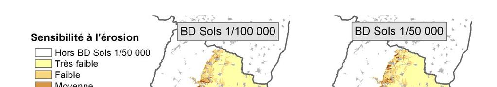
10 Comparison of MESALES results depending on soil map scale EGU-2010, Vienna
11 Comparison of MESALES results for two soil map scales 100 All cells, including the Rhine plain toute la carte incluant la plaine 100 Only cells with sensitivity > 1 sensibilité > 1 (élimination plaine, forêts et prairies) Frequency (%) % de la surface totale Frequency % de la surface totale (%) Difference sensibilité 1/ in erosion - sensibilité class 1/50000 Difference in erosion class sensibilité 1/ sensibilité 1/50000 Differences > 2 classes are quasi absent 90% of the cells have the same erosion class, but this is partly due to absence of slope (Rhine plain) and not to soil factors On 57 % of the cells: no difference in erosion sensitivity 1/ leads to an overestimation on 25 % and to an underestimation on 18 % of the surface
12 Erosion sensitivity index per commune erosion sensitivity per commune (Haut-Rhin) soil map 1/ soil map 1/
13 Ranking of 260 communes ranking of "communes" according to erosion sensitivity (Haut-Rhin) 300 soil map 1/ HIGH MIDDLE LOW soil map 1/ The selection of priority Ranks communes : 1 = highest for sensitivity action is difficult when using the 1/ soil map: classifying 260 = lowest them sensitivity in three or four groups is the best solution EGU-2010, Vienna
14 Sensitivity of LISEM to soil map scale Pedotransfert functions (SPAW) were used to derive LISEM soil-related parameters (Ks, Theta_s, psi) from the soil map attribute data Comparison of LISEM results (infiltration, erosion and sedimentation) using the 1/ soil map with a more detailed map (1/ or finer) on 1000 gridcells randomly chosen in the catchment

15 LISEM output Overland flow and routing
16 LISEM output Erosion
17 LISEM output Deposition
18 Time series at selected points débit (m3/s) Q m3/s P mm/h Conc g/l P (mm/h) ; Sed.conc (g/l) temps (min) EGU-2010, Vienna
 arable land and vineyards Stetten-Brinckheim 365 ha, slopes 5-10% loess-derived soils and small textural variations dominated by arable")
19 Two catchments were tested EGU-2010, Vienna Ergersheim 250 ha, slopes 2-5% variable soil types and textures (loess soils, clayey-calcareous soils and alluvial soils) arable land and vineyards Stetten-Brinckheim 365 ha, slopes 5-10% loess-derived soils and small textural variations dominated by arable land

 Ergersheim")
 1/100 000")

20 The soil maps tetten-brinckheim loess-derived soils) Ergersheim (contrasted soils) 1/ / / / / /25 000
21 Catchment Bassin versant with aux loess- sols derived homogènes soils (small textural Stetten-Brinckheim variations) Catchment Bassin versant with aux strongly sols contrasted contrastés soils (high textural Ergersheim variations) 1/ soil map Infiltration donnees sols aux 1/ Detailed soil map same with both soil Erosion maps infiltration (mm) 1 : 1 Results are essentially the 1/ soil map 1/ soil map erosion (ton/ha) 1 : donnees sols aux 1/ Detailed soil map Dépôts depot (ton/ha) 1 : A B C Infiltration infiltration (mm) 1 : donnees sols aux 1/ Detailed soil map differences: Erosion the 1/ erosion (ton/ha) 1 : donnees sols aux 1/ Detailed soil map Dépôts 10 depot (ton/ha) 1 : Infiltration Results shows significant map leads to underestimated infiltration, Erosion and overestimated erosion and deposition Deposition EGU-2010, Vienna
22 Catchment with loessderived soils (small textural variations) Bassin versant : Stetten-Brinckheim Différence infiltration entre échelle 1/ et 1/ (mm) Catchment with strongly contrasted soils (high textural variations) Bassin versant : Ergersheim Différence infiltration entre échelle 1/ et 1/ (mm) Infiltration Erosion The selection of hot spots within the catchment for reduced tillage or other erosion control measures is is difficult when using the Différence érosion entre échelle 1/ et 1/ (ton/ha) 1/ soil map for the Ergersheim catchment! 0 à 1 1 à 5 5 à à à 30 0 à à à 1 1 à 5 > 5 Différence érosion entre échelle 1/ et 1/ (ton/ha) 0 à 1 1 à 5 5 à à à 30 0 à à à 1 1 à 5 > 5
23 Conclusions Inappropriate soil map scale can be a significant error source for erosion model output, and being aware of this can avoid misuse of modelling results In such cases, possible solutions are: Refine soil (textural) information for the study area Generalize (through classification or spatial aggregation) the model output There is not one single appropriate soil map scale per model Higher textural variability in the study area requires higher resolutions of soil maps Such variability can be present at the regional scale, but as well in small catchments EGU-2010, Vienna


24 Acknowledgements Financing Risque, décision, territoire Model support Medales: Yves Le Bissonnais, Olivier Cerdan LISEM: Victor Jetten EGU-2010, Vienna

25 Thank you for your attention
Overland flow and erosion in agricultural lands
 Overland flow and erosion in agricultural lands Structure a. Introduction, processes and factors b. Impacts c. Models and applications FORM-OSE Post-Graduate Training School Living with hydro-geomorphological
Relative soil vulnerability and patterns of erosion during the muddy floods of on the South Downs, Sussex, UK
 Relative soil vulnerability and patterns of erosion during the muddy floods of 2000-2001 on the South Downs, Sussex, UK Hazel Faulkner, Jose Luis Ruiz & John Boardman South Downs East Sussex Due to a long
Sediment exports from French rivers. Magalie Delmas, Olivier Cerdan, Jean-Marie Mouchel*, Frédérique Eyrolles, Bruno Cheviron
 Sediment exports from French rivers Magalie Delmas, Olivier Cerdan, Jean-Marie Mouchel*, Frédérique Eyrolles, Bruno Cheviron Université Pierre et Marie Curie, Paris BRGM, Orléans ISRN, Cadarache Study
2013 Esri Europe, Middle East and Africa User Conference October 23-25, 2013 Munich, Germany
 2013 Esri Europe, Middle East and Africa User Conference October 23-25, 2013 Munich, Germany Environmental and Disaster Management System in the Valles Altos Region in Carabobo / NW-Venezuela Prof.Dr.habil.Barbara
Which map shows the stream drainage pattern that most likely formed on the surface of this volcano? A) B)
 B)") 1. When snow cover on the land melts, the water will most likely become surface runoff if the land surface is A) frozen B) porous C) grass covered D) unconsolidated gravel Base your answers to questions
1. When snow cover on the land melts, the water will most likely become surface runoff if the land surface is A) frozen B) porous C) grass covered D) unconsolidated gravel Base your answers to questions
Teacher s Pack Key Stage 3 GEOGRAPHY
 Teacher s Pack Key Stage 3 GEOGRAPHY Geography Key Stage 3 Fieldwork Worksheet Rivers: 1. Is the water fresh or salty? (test its resistance or specific gravity) 2. Do you know where the water is coming
Urban storm water management
 Urban storm water management Cooperation between geologists and land-use planners Philipp Schmidt-Thomé Geological Survey of Finland Background Urban flood modeling has become more topical during 21 st
VILLAGE INFORMATION SYSTEM (V.I.S) FOR WATERSHED MANAGEMENT IN THE NORTH AHMADNAGAR DISTRICT, MAHARASHTRA
 FOR WATERSHED MANAGEMENT IN THE NORTH AHMADNAGAR DISTRICT, MAHARASHTRA") VILLAGE INFORMATION SYSTEM (V.I.S) FOR WATERSHED MANAGEMENT IN THE NORTH AHMADNAGAR DISTRICT, MAHARASHTRA Abstract: The drought prone zone in the Western Maharashtra is not in position to achieve the agricultural
VILLAGE INFORMATION SYSTEM (V.I.S) FOR WATERSHED MANAGEMENT IN THE NORTH AHMADNAGAR DISTRICT, MAHARASHTRA Abstract: The drought prone zone in the Western Maharashtra is not in position to achieve the agricultural
Aldo Ferrero, Francesco Vidotto, Fernando De Palo. RUNOFF team
 TOPPS ACADEMY 15-1818 th June 2015 Grugliasco (TO) Aldo Ferrero, Francesco Vidotto, Fernando De Palo RUNOFF team DIAGNOSIS what data do we need? collection of territorial data (soils, elevation, slope,
GIS-based multiple criteria evaluation for spatial mine management Micaela Grigorescu (Geological Survey of Queensland)
") GIS-based multiple criteria evaluation for spatial mine management Micaela Grigorescu (Geological Survey of Queensland) ACARP Project C21041 (Jane H Hodgkinson, Micaela Preda-Grigorescu, Claire Côte, Habib
GIS-based multiple criteria evaluation for spatial mine management Micaela Grigorescu (Geological Survey of Queensland) ACARP Project C21041 (Jane H Hodgkinson, Micaela Preda-Grigorescu, Claire Côte, Habib
Floodplain modeling. Ovidius University of Constanta (P4) Romania & Technological Educational Institute of Serres, Greece
 Romania & Technological Educational Institute of Serres, Greece") Floodplain modeling Ovidius University of Constanta (P4) Romania & Technological Educational Institute of Serres, Greece Scientific Staff: Dr Carmen Maftei, Professor, Civil Engineering Dept. Dr Konstantinos
Floodplain modeling Ovidius University of Constanta (P4) Romania & Technological Educational Institute of Serres, Greece Scientific Staff: Dr Carmen Maftei, Professor, Civil Engineering Dept. Dr Konstantinos
Natural Susceptibility to Coastal Erosion: Methodology and Mapping Summary
 Natural Susceptibility to Coastal Erosion: Methodology and Mapping Summary. Introduction The Flood Risk Management (Scotland) Act 2009 (FRM Act) introduced a coordinated and partnership approach to how
3/3/2013. The hydro cycle water returns from the sea. All "toilet to tap." Introduction to Environmental Geology, 5e
 Introduction to Environmental Geology, 5e Running Water: summary in haiku form Edward A. Keller Chapter 9 Rivers and Flooding Lecture Presentation prepared by X. Mara Chen, Salisbury University The hydro
Soil erosion susceptibility and coastal evolution: examples in southern New Caledonia
 Pacific Island Countries GIS /RS User Conference Soil erosion susceptibility and coastal evolution: examples in southern New Caledonia Pascal DUMAS et Olivier COHEN University of New-Caledonia (EA 4242/
Running Water Earth - Chapter 16 Stan Hatfield Southwestern Illinois College
 Running Water Earth - Chapter 16 Stan Hatfield Southwestern Illinois College Hydrologic Cycle The hydrologic cycle is a summary of the circulation of Earth s water supply. Processes involved in the hydrologic
Effect of land cover / use change on soil erosion assessment in Dubračina catchment (Croatia)
") European Water 57: 171-177, 2017. 2017 E.W. Publications Effect of land cover / use change on soil erosion assessment in Dubračina catchment (Croatia) N. Dragičević *, B. Karleuša and N. Ožanić Faculty
European Water 57: 171-177, 2017. 2017 E.W. Publications Effect of land cover / use change on soil erosion assessment in Dubračina catchment (Croatia) N. Dragičević *, B. Karleuša and N. Ožanić Faculty
Erosion Surface Water. moving, transporting, and depositing sediment.
 + Erosion Surface Water moving, transporting, and depositing sediment. + Surface Water 2 Water from rainfall can hit Earth s surface and do a number of things: Slowly soak into the ground: Infiltration
Drainage Basin Geomorphology. Nick Odoni s Slope Profile Model
 Drainage Basin Geomorphology Nick Odoni s Slope Profile Model Odoni s Slope Profile Model This model is based on solving the mass balance (sediment budget) equation for a hillslope profile This is achieved
The effect of soil physical parameters on soil erosion. Introduction. The K-factor
 Geographical Bulletin 2004. Tom. LIII. No. 1 2. pp.77 84. The effect of soil physical parameters on soil erosion ÁDÁM KERTÉSZ TAMÁS HUSZÁR GERGELY JAKAB 1 Introduction The factor K of the Universal Soil
INTRODUCTION TO ARCGIS 10
 Department of Irrigation, Drainage and Landscape Engineering, Faculty of Civil Engineering, CTU Prague Institute of Hydraulics and Rural Water Management BOKU Vienna INTRODUCTION TO ARCGIS 10 MAIN WINDOW
GEOL 1121 Earth Processes and Environments
 GEOL 1121 Earth Processes and Environments Wondwosen Seyoum Department of Geology University of Georgia e-mail: seyoum@uga.edu G/G Bldg., Rm. No. 122 Seyoum, 2015 Chapter 6 Streams and Flooding Seyoum,
CHAPTER 5 EVIDENCES AND PARAMETERS AFFECTING DEBRIS FLOW-FLOOD PROCESSES IN NAM KO YAI SUB-CATCHMENT
 CHAPTER 5 EVIDENCES AND PARAMETERS AFFECTING DEBRIS FLOW-FLOOD PROCESSES IN NAM KO YAI SUB-CATCHMENT In this chapter, evidences of geotechnical properties of rocks and soils, as well as evidence of the
Streams. Stream Water Flow
 CHAPTER 14 OUTLINE Streams: Transport to the Oceans Does not contain complete lecture notes. To be used to help organize lecture notes and home/test studies. Streams Streams are the major geological agents
Remote Sensing and GIS Applications for Hilly Watersheds SUBASHISA DUTTA DEPARTMENT OF CIVIL ENGINEERING IIT GUWAHATI
 Remote Sensing and GIS Applications for Hilly Watersheds SUBASHISA DUTTA DEPARTMENT OF CIVIL ENGINEERING IIT GUWAHATI Deciding Alternative Land Use Options in a Watershed Using GIS Source: Anita Prakash
Weathering, Erosion, Deposition, and Landscape Development
 Weathering, Erosion, Deposition, and Landscape Development I. Weathering - the breakdown of rocks into smaller particles, also called sediments, by natural processes. Weathering is further divided into
Gateway Trail Project
 Gateway Trail Project Debris Flow Hazard Assessment By: Juan de la Fuente April 30, 2010 Background- On April 22, 2010, the Shasta-Trinity National Forest (Mt. Shasta-McCloud Unit) requested a geologic
Conservation Planning evaluate land management alternatives to reduce soil erosion to acceptable levels. Resource Inventories estimate current and
 Conservation Planning evaluate land management alternatives to reduce soil erosion to acceptable levels. Resource Inventories estimate current and projected erosion levels and their impact on natural resource
EROSION AND DEPOSITION
 CHAPTER 8 EROSION AND DEPOSITION SECTION 8 1 Changing Earth s Surface (pages 252-255) This section explains how sediment is carried away and deposited elsewhere to wear down and build up Earth s surface.
Soil Formation. Lesson Plan: NRES B2-4
 Soil Formation Lesson Plan: NRES B2-4 1 Anticipated Problems 1. What are five different factors that affect soil formation? 2. What are some different types of parent material that affect soils? 3. What
8 Current Issues and Research on Sediment Movement in the River Catchments of Japan
 8 Current Issues and Research on Sediment Movement in the River Catchments of Japan YUTAKA ICHIKAWA INTRODUCTION Prediction of sediment movement is one of the challenging tasks in water-related research.
Fukien Secondary School Monthly Vocabulary/Expression List for EMI Subjects Secondary Two. Subject: Geography
 Focus: General Specific : Section Two : Unit One 1 Landslide 2 Downslope movement 3 Rock 4 Soil 5 Gravity 6 Natural hazard 7 Rainwater 8 Friction 9 Hilly relief 10 Unstable 11 Season 12 Saturated 13 Construction
MODULE 7 LECTURE NOTES 5 DRAINAGE PATTERN AND CATCHMENT AREA DELINEATION
 MODULE 7 LECTURE NOTES 5 DRAINAGE PATTERN AND CATCHMENT AREA DELINEATION 1. Introduction Topography of the river basin plays an important role in hydrologic modelling, by providing information on different
COASTAL QUATERNARY GEOLOGY MAPPING FOR NSW: EXAMPLES AND APPLICATIONS
 COASTAL QUATERNARY GEOLOGY MAPPING FOR NSW: EXAMPLES AND APPLICATIONS A Troedson Geological Survey of New South Wales Abstract Detailed geological mapping of the coastal plains of regional NSW was undertaken
Each basin is surrounded & defined by a drainage divide (high point from which water flows away) Channel initiation
 Channel initiation") DRAINAGE BASINS A drainage basin or watershed is defined from a downstream point, working upstream, to include all of the hillslope & channel areas which drain to that point Each basin is surrounded &
DRAINAGE BASINS A drainage basin or watershed is defined from a downstream point, working upstream, to include all of the hillslope & channel areas which drain to that point Each basin is surrounded &
Pleistocene alteration of drainage network and diverse surface morphology forced by basement structure in the foreland of the Eastern Alps
 This study was carried out in the framework of a project sponsored by the Hungarian National Science Foundation (OTKA NK83400) and TÁMOP-4.2.2/B-10/1-2010-0030 Pleistocene alteration of drainage network
MAPPING OF THE MICRORELIEF STRUCTURES USING TOPOGRAPHIC DATA
 MAPPING OF THE MICRORELIEF STRUCTURES USING TOPOGRAPHIC DATA DOI: https://doi.org/10.18509/agb.2018.03 UDK: 528.93.06(470) Evgeny Panidi 1, Lubov Trofimetz 2, Julia Sokolova 1, Elena Kunaeva 1, 3 1 Saint
Lecture Outlines PowerPoint. Chapter 5 Earth Science 11e Tarbuck/Lutgens
 Lecture Outlines PowerPoint Chapter 5 Earth Science 11e Tarbuck/Lutgens 2006 Pearson Prentice Hall This work is protected by United States copyright laws and is provided solely for the use of instructors
ADELA PAȘCA, TEODOR RUSU. Bucharest, June 2018
 GIS INTEGRATION OF CLIMATE CHANGE THROUGH FAST CALCULATION OF TEMPERATURE AND PRECIPITATION MAPS FOR USE IN AGRICULTURAL LAND QUALITATIVE ASSESSMENT. CASE STUDY: ICLOD COMMUNE, CLUJ COUNTY, ROMANIA ADELA
Gully erosion in winter crops: a case study from Bragança area, NE Portugal
 Gully erosion in winter crops: a case study from Bragança area, NE Portugal T. de Figueiredo Instituto Politécnico de Bragança (IPB/ESAB), CIMO Mountain Research Centre, Bragança, Portugal Foreword This
Chapter 7 Mudflow Analysis
 Chapter 7 Mudflow Analysis 7.0 Introduction This chapter provides information on the potential and magnitude of mud floods and mudflows that may develop in Aspen due to rainfall events, snowmelt, or rain
Urban Erosion Potential Risk Mapping with GIS
 Urban Erosion Potential Risk Mapping with GIS ESRI Water Conference San Diego, CA Jan 29-Feb 1, 2018 Dr. Randy Dymond, PE, F.ASCE, D.WRE Co-investigators: Amanda Weikmann, MS Student Dr. Clay Hodges, PE
APPROACH TO THE SPANISH WATER ORGANISATION IMPROVING FLOOD HAZARD MAPPING, LAWS AND AUTHORITIES COORDINATION
 "Workshop On Land Use Planning And Water Management, With Focus On Flood Risk Management Oslo, Norway. Wednesday 31 January and Thursday 1 February 2007 APPROACH TO THE SPANISH WATER ORGANISATION IMPROVING
Chapter 7 Mudflow Analysis
 Chapter 7 Mudflow Analysis 7.0 Introduction This chapter provides information on the potential and magnitude of mud floods and mudflows that may develop in Aspen due to rainfall events, snowmelt, or rain
Notes and Summary pages:
 Topographic Mapping 8.9C Interpret topographical maps and satellite views to identify land and erosional features and predict how these shapes may be reshaped by weathering ATL Skills: Communication taking
Directorate E: Sectoral and regional statistics Unit E-4: Regional statistics and geographical information LUCAS 2018.
 EUROPEAN COMMISSION EUROSTAT Directorate E: Sectoral and regional statistics Unit E-4: Regional statistics and geographical information Doc. WG/LCU 52 LUCAS 2018 Eurostat Unit E4 Working Group for Land
Subsurface Erosion in Response to Land Management Changes and Soil Hydropedology. G.V. Wilson, J. R. Rigby, S.M. Dabney
 Subsurface Erosion in Response to Land Management Changes and Soil Hydropedology G.V. Wilson, J. R. Rigby, S.M. Dabney USDA-ARS National Sedimentation Laboratory Soil Pipeflow & Internal Erosion Impacts
Landscape Development
 Landscape Development Slopes Dominate Natural Landscapes Created by the interplay of tectonic and igneous activity and gradation Deformation and uplift Volcanic activity Agents of gradation Mass wasting
Name: Mid-Year Review #2 SAR
 Name: Mid-Year Review #2 SAR Base your answers to questions 1 through 3 on on the diagram below, which shows laboratory materials used for an investigation of the effects of sediment size on permeability,
Internationales Symposion INTERPRAEVENT 2004 RIVA / TRIENT
 APPLICATION TO PAST DISASTERS OF A METHOD OF SETTING APPLICATION THE RANGE TO OF PAST DEBRIS DISASTERS FLOW OF DAMAGE A METHOD TO HOUSES OF SETTING THE RANGE OF DEBRIS FLOW DAMAGE TO HOUSES Hideaki Mizuno
Determination of flood risks in the yeniçiftlik stream basin by using remote sensing and GIS techniques
 Determination of flood risks in the yeniçiftlik stream basin by using remote sensing and GIS techniques İrfan Akar University of Atatürk, Institute of Social Sciences, Erzurum, Turkey D. Maktav & C. Uysal
Review Using the Geographical Information System and Remote Sensing Techniques for Soil Erosion Assessment
 Polish J. of Environ. Stud. Vol. 19, No. 5 (2010), 881-886 Review Using the Geographical Information System and Remote Sensing Techniques for Soil Erosion Assessment Nuket Benzer* Landscape Architecture
Spatial Units, Scaling and Aggregation (Level 1) October 2017
 October 2017") Spatial Units, Scaling and Aggregation (Level 1) October 2017 Overview: Spatial Units 1. Learning objectives 2. Review of Level 0 (5m) 3. Level 1 (Compilers): Presentation & group exercise Spatial units
Spatial Units, Scaling and Aggregation (Level 1) October 2017 Overview: Spatial Units 1. Learning objectives 2. Review of Level 0 (5m) 3. Level 1 (Compilers): Presentation & group exercise Spatial units
WATERSHED MANAGEMENT - A GIS APPROACH
 IMPACT: International Journal of Research in Applied, Natural and Social Sciences (IMPACT: IJRANSS) ISSN (P): 2347-4580; ISSN (E): 2321-8851 Vol. 4, Issue 6, Jun 2016, 109-116 Impact Journals WATERSHED
APPENDIX E. GEOMORPHOLOGICAL MONTORING REPORT Prepared by Steve Vrooman, Keystone Restoration Ecology September 2013
 APPENDIX E GEOMORPHOLOGICAL MONTORING REPORT Prepared by Steve Vrooman, Keystone Restoration Ecology September 2 Introduction Keystone Restoration Ecology (KRE) conducted geomorphological monitoring in
Flood modelling and impact of debris flow in the Madarsoo River, Iran
 Monitoring, Simulation, Prevention and Remediation of Dense and Debris Flows 69 Flood modelling and impact of debris flow in the Madarsoo River, Iran S. Tjerry 1, O. Z. Jessen 2, K. Morishita 3 & H. G.
A Detailed First Pass coastal hazard assessment for a long complex coast: Kingborough LGA, Tasmania
 A Detailed First Pass coastal hazard assessment for a long complex coast: Kingborough LGA, Tasmania Chris Sharples & Paul Donaldson University of Tasmania September 2012 Kingborough LGA, south-eastern
The last three sections of the main body of this report consist of:
 Threatened and Endangered Species Geological Hazards Floodplains Cultural Resources Hazardous Materials A Cost Analysis section that provides comparative conceptual-level costs follows the Environmental
USING HYPERSPECTRAL IMAGERY
 USING HYPERSPECTRAL IMAGERY AND LIDAR DATA TO DETECT PLANT INVASIONS 2016 ESRI CANADA SCHOLARSHIP APPLICATION CURTIS CHANCE M.SC. CANDIDATE FACULTY OF FORESTRY UNIVERSITY OF BRITISH COLUMBIA CURTIS.CHANCE@ALUMNI.UBC.CA
Sediment yield estimation from a hydrographic survey: A case study for the Kremasta reservoir, Western Greece
 Sediment yield estimation from a hydrographic survey: A case study for the Kremasta reservoir, Western Greece 5 th International Conference Water Resources Management in the Era of Transition,, Athens,
Spectroscopy Applications
 Spectroscopy Applications Soil spectroscopy as a tool for the spatial assessment of soil erosion states in agricultural semi-arid Spain Sabine Chabrillat 1, Thomas Schmid 2, Robert Milewski 1, Manuel Rodriguez
Watershed Processes and Modeling
 Watershed Processes and Modeling Pierre Y. Julien Hyeonsik Kim Department of Civil Engineering Colorado State University Fort Collins, Colorado Kuala Lumpur - May Objectives Brief overview of Watershed
Forest Hydrology: Lect. 9. Contents. Runoff, soil water and infiltration
 Forest Hydrology: Lect. 9 Contents Runoff, soil water and infiltration Learning objectives:. - Hillslope runoff generation processes; - Dynamics of runoff generation processes; - Hortonian and Dunnian
CHAPTER VII FULLY DISTRIBUTED RAINFALL-RUNOFF MODEL USING GIS
 80 CHAPTER VII FULLY DISTRIBUTED RAINFALL-RUNOFF MODEL USING GIS 7.1GENERAL This chapter is discussed in six parts. Introduction to Runoff estimation using fully Distributed model is discussed in first
Aquifer an underground zone or layer of sand, gravel, or porous rock that is saturated with water.
 Aggradation raising of the streambed by deposition that occurs when the energy of the water flowing through a stream reach is insufficient to transport sediment conveyed from upstream. Alluvium a general
Design Flood Estimation in Ungauged Catchments: Quantile Regression Technique And Probabilistic Rational Method Compared
 Design Flood Estimation in Ungauged Catchments: Quantile Regression Technique And Probabilistic Rational Method Compared N Rijal and A Rahman School of Engineering and Industrial Design, University of
PHASE 1 STUDIES UPDATE EROSION WORKING GROUP
 PHASE 1 STUDIES UPDATE EROSION WORKING GROUP Presented By MICHAEL WOLFF, PG Erosion Study Area Manager West Valley Demonstration Project Quarterly Public Meeting February 24, 2016 OUTLINE Study 1 Terrain
Environmental Geology Chapter 9 Rivers and Flooding
 Environmental Geology Chapter 9 Rivers and Flooding Flooding in Pakistan 2010-1600 killed/20000 affected The hydrologic cycle is powered by the Sun The cycle includes evaporation, precipitation, infiltration,
Block Level Micro Watershed Prioritization Based on Morphometric and Runoff Parameters
 Cloud Publications International Journal of Advanced Remote Sensing and GIS 2016, Volume 5, Issue 11, pp. 1981-1987 ISSN 2320-0243, Crossref: 10.23953/cloud.ijarsg.76 Research Article Open Access Block
Sediment Capture in Pervious Concrete Pavement tsystems: Effects on Hydrological Performance and Suspended Solids
 Concrete Sustainability Conference April 14 th 2010, Tempe, AZ Sediment Capture in Pervious Concrete Pavement tsystems: Effects on Hydrological l Performance and Suspended Solids Discharge Luis A. Mata,
Basin characteristics
 Basin characteristics From hydrological processes at the point scale to hydrological processes throughout the space continuum: point scale à river basin The watershed characteristics (shape, length, topography,
Spatio-temporal models
 Spatio-temporal models Involve a least a three dimensional representation of one or more key attribute variation in planar (X-Y) space and through time. (a 4 th dimension could also be use, like Z for
Soil and Water Conservation Engineering Prof. Rajendra Singh Department of Agricultural and Food Engineering Indian Institute of Technology, Kharagpur
 Soil and Water Conservation Engineering Prof. Rajendra Singh Department of Agricultural and Food Engineering Indian Institute of Technology, Kharagpur Lecture 04 Soil Erosion - Mechanics Hello friends
SPOT DEM Product Description
 SPOT DEM Product Description Version 1.1 - May 1 st, 2004 This edition supersedes previous versions Acronyms DIMAP DTED DXF HRS JPEG, JPG DEM SRTM SVG Tiff - GeoTiff XML Digital Image MAP encapsulation
Sediment- yield estimation, by M-PSIAC method in a GIS environment, case study:jonaghn river sub basin(karun basin)
") Sediment- yield estimation, by M-PSIAC method in a GIS environment, case study:jonaghn river sub basin(karun basin) Yavari-shahla *,Khdabakhsh-Saeed,Mohseni-Hasan, Rezai- Khalil Corresponding author: a
Sediment- yield estimation, by M-PSIAC method in a GIS environment, case study:jonaghn river sub basin(karun basin) Yavari-shahla *,Khdabakhsh-Saeed,Mohseni-Hasan, Rezai- Khalil Corresponding author: a
STREAM SYSTEMS and FLOODS
 STREAM SYSTEMS and FLOODS The Hydrologic Cycle Precipitation Evaporation Infiltration Runoff Transpiration Earth s Water and the Hydrologic Cycle The Hydrologic Cycle The Hydrologic Cycle Oceans not filling
Precipitation Evaporation Infiltration Earth s Water and the Hydrologic Cycle. Runoff Transpiration
 STREAM SYSTEMS and FLOODS The Hydrologic Cycle Precipitation Evaporation Infiltration Earth s Water and the Hydrologic Cycle Runoff Transpiration The Hydrologic Cycle The Hydrologic Cycle Oceans not filling
Teacher s Pack Key Stages 1 and 2 GEOGRAPHY
 Teacher s Pack Key Stages 1 and 2 GEOGRAPHY Geography Key Stage 1 & 2 Fieldwork Worksheet Rivers: 1. Is the water fresh or salty? (test its resistance or specific gravity) FRESH 2. Do you know where the
Effect of Runoff and Sediment from Hillslope on Gully Slope In the Hilly Loess Region, North China**
 This paper was peer-reviewed for scientific content. Pages 732-736. In: D.E. Stott, R.H. Mohtar and G.C. Steinhardt (eds). 2001. Sustaining the Global Farm. Selected papers from the 10th International
Science EOG Review: Landforms
 Mathematician Science EOG Review: Landforms Vocabulary Definition Term canyon deep, large, V- shaped valley formed by a river over millions of years of erosion; sometimes called gorges (example: Linville
Erosion Susceptibility in the area Around the Okanogan Fire Complex, Washington, US
 Erosion Susceptibility in the area Around the Okanogan Fire Complex, Washington, US 1. Problem Construct a raster that represents susceptibility to erosion based on lithology, slope, cover type, burned
Appendix E Guidance for Shallow Flooding Analyses and Mapping
 Appendix E Guidance for Shallow Flooding Analyses and Mapping E.1 Introduction Different types of shallow flooding commonly occur throughout the United States. Types of flows that result in shallow flooding
LI Yong (1,2), FRIELINGHAUS Monika (1), BORK Hans-Rudolf (1), WU Shuxia (2), ZHU Yongyi (2)
, FRIELINGHAUS Monika (1), BORK Hans-Rudolf (1), WU Shuxia (2), ZHU Yongyi (2)") Scientific registration n : Symposium n : 31 Presentation : poster Spatial patterns of soil redistribution and sediment delivery in hilly landscapes of the Loess Plateau Motifs spaciaux de zones d'érosion
Scientific registration n : Symposium n : 31 Presentation : poster Spatial patterns of soil redistribution and sediment delivery in hilly landscapes of the Loess Plateau Motifs spaciaux de zones d'érosion
Regionalization Methods for Watershed Management - Hydrology and Soil Erosion from Point to Regional Scales
 This paper was peer-reviewed for scientific content. Pages 1062-1067. In: D.E. Stott, R.H. Mohtar and G.C. Steinhardt (eds). 2001. Sustaining the Global Farm. Selected papers from the 10th International
Coupling a basin erosion and river sediment transport model into a large scale hydrological model
 Hydrology and Geodynamics of the basins of South America 4 th scientific meeting of ORE HYBAM www.ore-hybam.org Lima, 6-9 September 2011 Coupling a basin erosion and river sediment transport model into
Diagnosis for buffer zone implementation Detailed practical approach
 Diagnosis for buffer zone implementation Detailed practical approach J. Gril G. Le Hénaff L. Liger (GIS application) Irstea (ex Cemagref), Lyon Centre December 2011 Foreword (1) "What is simple is false.
Sub-watershed prioritization based on potential zones of Kuttiadi river basin, A Geo-Morphometric approach using GIS
 INTERNATIONAL JOURNAL OF GEOMATICS AND GEOSCIENCES Volume 8, No 1, 2018 Copyright by the authors - Licensee IPA- Under Creative Commons license 3.0 Research article ISSN 0976 4380 Sub-watershed prioritization
PREDICTION OF RUN-OUT PROCESS FOR A DEBRIS FLOW TRIGGERED BY A DEEP RAPID LANDSLIDE
 DOI: 10.4408/IJEGE.2011-03.B-053 PREDICTION OF RUN-OUT PROCESS FOR A DEBRIS FLOW TRIGGERED BY A DEEP RAPID LANDSLIDE Y. NISHIGUCHI (*), T. UCHIDA (*), K. TAMURA (*) & Y. SATOFUKA (**) (*) Public Works
Unit 7.2 W.E.D. & Topography Test
 Name: Score: Unit 7.2 W.E.D. & Topography Test 1. 2. 3. 4. 5. 6. 7. 8. 9. 10. 11. 12. 13. 14. 15. 16. 17. 18. 19. 20. 21. 22. 23. 24. 25. 1. The formation of mountains is due mainly to while the destruction
11/12/2014. Running Water. Introduction. Water on Earth. The Hydrologic Cycle. Fluid Flow
 Introduction Mercury, Venus, Earth and Mars share a similar history, but Earth is the only terrestrial planet with abundant water! Mercury is too small and hot Venus has a runaway green house effect so
A Temporal Hydrologic Database for Rapidly Changing Landscapes
 A Temporal Hydrologic Database for Rapidly Changing Landscapes Using Mt. St. Helens in Washington as a Pilot Site Adam Mosbrucker Geog 575 BACKGROUND: Client / User U.S. Geological Survey Cascades Volcano
Unit E: Basic Principles of Soil Science. Lesson 2: Understanding Soil Formation
 Unit E: Basic Principles of Soil Science Lesson 2: Understanding Soil Formation Important Terms Alluvium Bedrock Chemical weathering Climate Glacial till Loess Native vegetation Organic matter Outwash
Module/Unit: Landforms Grade Level: Fifth
 Module/Unit: Landforms Grade Level: Fifth PA Academic Standards for Science and Technology and Environment and Ecology: 3.1.7.B Describe the use of models as an application or scientific or technological
Existing NWS Flash Flood Guidance
 Introduction The Flash Flood Potential Index (FFPI) incorporates physiographic characteristics of an individual drainage basin to determine its hydrologic response. In flash flood situations, the hydrologic
Scientific registration n : 2180 Symposium n : 35 Presentation : poster MULDERS M.A.
 Scientific registration n : 2180 Symposium n : 35 Presentation : poster GIS and Remote sensing as tools to map soils in Zoundwéogo (Burkina Faso) SIG et télédétection, aides à la cartographie des sols
Chapter 6 Mapping and Online Tools
 Chapter 6 Mapping and Online Tools The stream site you monitor is just part of a much larger system. When analyzing stream health, it is important to take a holistic view by considering the entire watershed.
Scientific registration number: 1347 Symposium N o : 17 Presentation: Oral
 Scientific registration number: 147 Symposium N o : 17 Presentation: Oral The use of integrated AVHRR and DEM data for small scale soil mapping Utilisation intégrée de données AVHRR et MNT pour la cartographie
Nguyen Ngoc Thach 1, *, Pham Xuan Canh 2 VNU University of Science, 334 Nguyen Trai, Hanoi, Vietnam
 VNU Journal of Science, Earth Sciences 8 (01) 44-6 Risk assessment of flash muddy flood and inundation of western Tam Dao mountainous region, Vinh Phuc province, Vietnam by using intergrated concept of
EPS 50 Lab 6: Maps Topography, geologic structures and relative age determinations
 Name: EPS 50 Lab 6: Maps Topography, geologic structures and relative age determinations Introduction: Maps are some of the most interesting and informative printed documents available. We are familiar
Human Activities and Environmental Risks Natural Hazards and Urban Development Issues Vallée de la Bruche, Alsace
 STER 98 Remote Sensing Project Tutorials 1 Human Activities and Environmental Risks Natural Hazards and Urban Development Issues Vallée de la Bruche, Alsace Stephen Clandillon, SERTIT, Parc d'innovation,
National Hydrology committee of Afghanistan (NHCA) Sedimentation in Reservoire
 Sedimentation in Reservoire") National Hydrology committee of Afghanistan (NHCA) Sedimentation in Reservoire OCt.2007 Prof. Mohammad Qasem Seddeqy KPU بسم االله الرحمن الرحيم وجعلنامن الماءکل شي ء حی 30 واز ا ب هر چيزی رازنده گردانيدیم
National Hydrology committee of Afghanistan (NHCA) Sedimentation in Reservoire OCt.2007 Prof. Mohammad Qasem Seddeqy KPU بسم االله الرحمن الرحيم وجعلنامن الماءکل شي ء حی 30 واز ا ب هر چيزی رازنده گردانيدیم