Pedodiversity and Island Soil Geography: Testing the Driving Forces for Pedological Assemblages in Archipelagos of Different Origins
|
|
|
- Dylan Stevenson
- 6 years ago
- Views:
Transcription
1 Pedodiversity and Island Soil Geography: Testing the Driving Forces for Pedological Assemblages in Archipelagos of Different Origins William R. Effland, Ph.D. Soil Survey Division, USDA/NRCS A. Rodriguez-Rodriguez, Ph.D. Univ. de La Laguna, Tenerife, Canary Islands Juan J. Ibanez, Ph.D. Centro de Investigaciones sobre desertificacion, Spain 18 th World Congress of Soil Science Symposium 1.2A Spatial, Societal and Environmental Aspects of Pedodiversity July 10, 2006
2 Overview Biodiversity and Pedodiversity Research Objectives Island Study Areas Methods Results Hawaiian Islands Canary Islands
3 Introduction Island Biodiversity and Biological Communities Ecological Research Conservation Biology Limited studies of Pedodiversity and Soil Geography in Archipelagos
4 Quantification of Biological Diversity Definition of Diversity (Huston, 1994) Two primary components with statistical properties for any mixture of different objects The number of different types of objects in the sample Relative number or amount of each different type of object
5 Diversity and Human Judgement Definition of Diversity (cont d.) Two unavoidable value judgements Are the selected classes (and, by inference, class differentia) different enough to be considered separate types of objects? Are objects in a specific class similar enough to be considered the same type of object?
6 Role of Pedodiversity Analysis Conservation and preservation of the pedosphere as a natural resource Preservation of soils in their natural state increases opportunities to study ecological structure, function and dynamic properties Interactions with spatial pattern analysis
7 Research Objectives Analyze similarities and differences in the pedosphere for three archipelagos of different origins Study soil geographic distributions using taxonomic attributes Investigate landscape ecology methods for applications to pedologic research
8 Island Study Areas Hawaiian Islands Canary Islands Aegean Islands


9 Study Areas Hawaiian Islands Canary Islands Aegean Islands
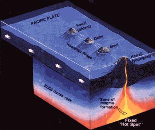
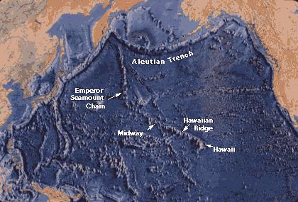
10 Genetic Classification of Oceanic Islands (Nunn, 1994) Level One Plate-boundary islands Level Two Islands at divergent plate boundaries Islands at convergent plate boundaries Islands along traverse plate boundaries Intraplate islands Linear groups of islands Isolated islands Clustered groups of islands

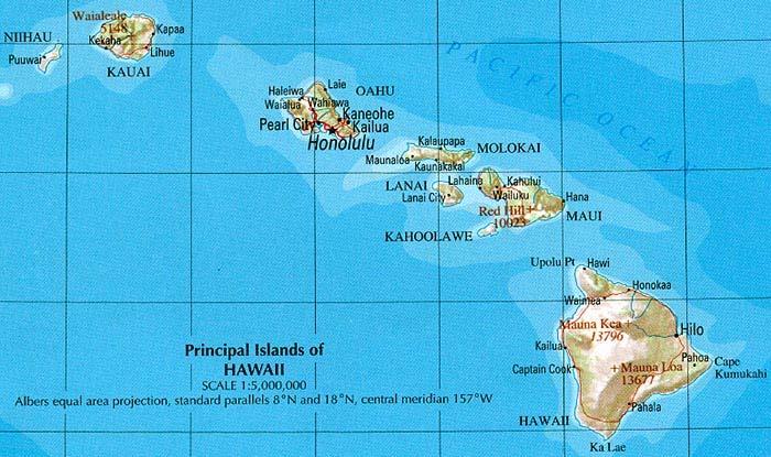
11 Hawaiian Islands
12

13 Aegean Islands
14 Methods Soil Databases Hawaiian Islands 6 main islands in southeastern region of island chain State Soil Geographic Database (STATSGO) 1:250,000 scale soils data Canary Islands 7 islands and 4 islets 1:250,000 scale unpublished (A. Rodriguez-Rodriguez) Aegean Islands CORINE database [Briggs and Martin, 1988] 682 islands with mostly calcareous and volcanic parent materials 1:1,000,000 scale EU soils map with FAO legend
15 Richness Indices Proportional abundance of an object Calculated with Excel software Shannon Diversity Index H = - p i.lnp i p i = n i /N where n i is the area of the i-th category and N is the total area Shannon and Weaver, 1949 Evenness E = H / H max = H / ln S E ranges from 0 to 1 S is richness or number of categories
16 Biogeographical Analyses Species-Area Relationship S = ca z S is the Number of species or taxa c is an empirical constant A is the Area z is a exponential value (theoretically near 0.25) McArthur and Wilson, 1967
17 Taxonomic Pedodiversity Richness Variety of species (e.g., soil types) Indices Number of different objects at a site Count of known soil types in a defined sampling unit Evenness or Equity Distribution of individuals among the species Object Abundance Models Distribution model that is closest fit to observed pattern of object abundance Examples log series, geometric series
18

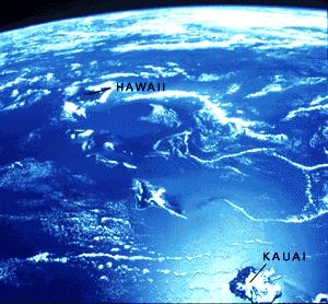
19 Hawaiian Islands
20
21
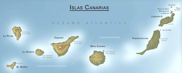
 12,000 10,000 Area (km2) and Maximum Elevation (m) 8,000")

22 Hawaiian Islands' Area and Maximum Elevation (Photo of HI landscape with taro fields, source: USDA/NRCS, 2005) 12,000 10,000 Area (km2) and Maximum Elevation (m) 8,000 6,000 4,000 2,000 0 Hawaii Maui Lanai Molokai Oahu Kauai Area_km Max_elev_m


23 Geomorphic Dynamics of the Hawaiian Islands
24 STATSGO Soil Order Area and Relative Island Age for the Hawaiian Islands (Excluding Miscellaneous Areas) Histosols Entisols Andisols Inceptisols Alfisols Aridisols Mollisols Ultisols Oxisols 3,500 3,000 Area Percent of Hawaii Island The Youngest and Largest Island Andisols 5% Entisols 5% Area Percent of Kauai The Oldest and Modal Size Island Ultisols 6% Entisols 26% 2,500 Inceptisols 51% Oxisols 28% Area (km 2 ) 2,000 1,500 Histosols 35% Mollisols 10% Inceptisols 26% 1, Hawaii Maui Lanai Molokai Oahu Kauai

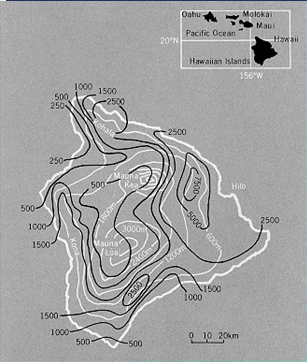
25 Hawaii Island Climate and Precipitation Water Balance Source: USGS,
26 Soil Order Area Distributions (km 2 ) Among the Hawaiian Islands Hawaii Maui Lanai Molokai Oahu Kauai 100% 90% 80% 70% Relative Percentage 60% 50% 40% 30% 20% 10% 0% Alfisols Andisols Aridisols Entisols Histosols Inceptisols Mollisols Oxisols Spodosols Ultisols Vertisols Kauai Oahu Molokai Lanai Maui Hawaii

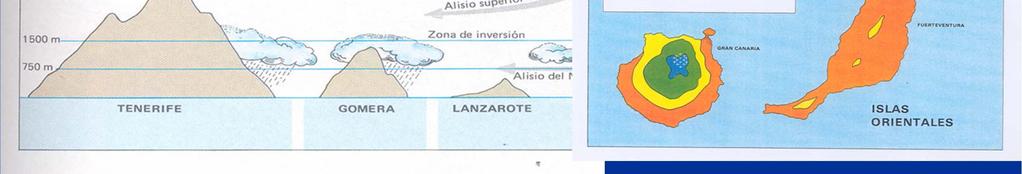
27 Canary Islands Fits of diferent variables to power laws in Canay Islands c z r dst c z r dst Area-Relief Relief-Area *** *** *** *** Area-FAO Soil* Relief-FAO Soil* Area-USDA Soil Relief USDA-Soil Area-Bioclimate Relief-Bioclimate < Area-Wild Veg Relief-Wild Veg. < Area-Geology Relief-Geology Area-Quatern. < Relief Quaternary Area-Nº Plants * < Relief-Nº Plants* < Area-Coleopt.* Relief-Nº Coleópt* < Area-Habitats Relief-Habitats <
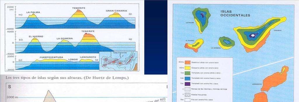

28

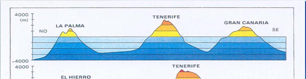
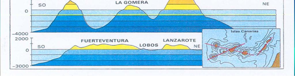
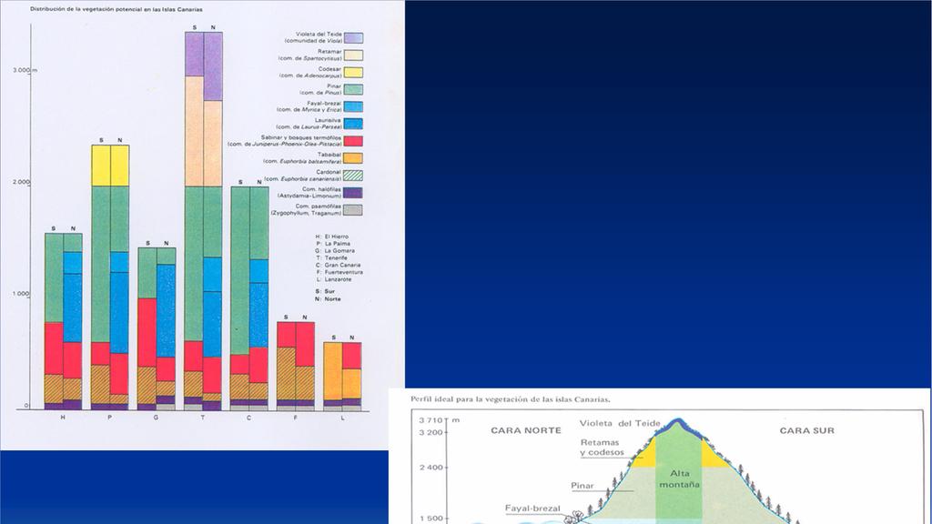
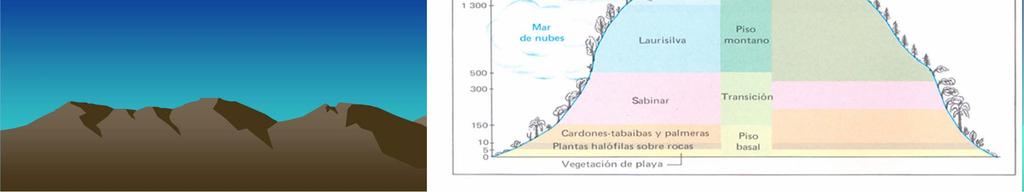
29 Canary Islands


30 Canary Islands Diversity Analysis


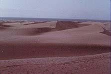
31 Canary Islands Mean Annual Precipitation
32
33 Pedodiversity Analysis Conservation and preservation of the pedosphere as a natural resource Preservation of soils in their natural state Increased opportunities to study ecological structure, function and dynamic properties Interactions with spatial pattern analysis

34 Thank You! Questions?
Overview. Rock weathering Functions of soil Soil forming factors Soil properties
 UN-FAO A. Healthy soils are the basis for healthy food production. B. A tablespoon of normal topsoil has more microorganisms than the entire human population on Earth. C. It can take up to 1,000 years
Lecture 7: Introduction to Soil Formation and Classification
 Lecture 7: Introduction to Soil Formation and Classification Soil Texture and Color Analysis Lab Results Soil A: Topsoil from Prof. Catalano s backyard Soil B: Soil above beach at Castlewood State Park
Physical Geology, 15/e
 Lecture Outlines Physical Geology, 15/e Plummer, Carlson & Hammersley Weathering and Soil Physical Geology 15/e, Chapter 5 Weathering, Erosion and Transportation Rocks exposed at Earth s surface are constantly
GEOL Lab #11 Information (Guidelines for Student Soil Presentations on April 8)
") GEOL 333 - Lab #11 Information (Guidelines for Student Soil Presentations on April 8) Assignment During Lab on April 8, you will give an oral presentation about one of the 12 soil orders (categories).
GEOL 333 - Lab #11 Information (Guidelines for Student Soil Presentations on April 8) Assignment During Lab on April 8, you will give an oral presentation about one of the 12 soil orders (categories).
Chemical Weathering and Soils
 Chemical Weathering and Soils Fresh rocks and minerals that once occupied the outermost position reached their present condition of decay through a complex of interacting physical, chemical, and biological
Weathering The effects of the physical and chemical environment on the decomposition of rocks
 Weathering The effects of the physical and chemical environment on the decomposition of rocks - Igneous rocks form at high temperatures and the constituent minerals reflect the conditions of formation.
Classification according to patent rock material/origin, soil distribution and orders
 Classification according to patent rock material/origin, soil distribution and orders Alluvial Soils Shales and Sandstone Soils Limestone Soils Chocolate Hills: Limestone formation Andesite and Basalt
STUDENT SOIL PRESENTATIONS
 STUDENT SOIL PRESENTATIONS Soil Order (and informal name) Student Name(s) Alfisol = deciduous forest soil Andisol = formed on volcanic ash Aridisol = desert soil Entisol = alluvium soil Gelisol = tundra
The Lithosphere. Definition
 10/23/2017 www.komar.de The Lithosphere Modified lecture of Dr. Ben Sullivan Definition io9.com tedquarters.net Lithos = rocky; Rocky sphere Skin of an apple Two basic types crust: oceanic, continental
Monday, Oct Field trip A1 & A2 signups: make sure you are where you think you should be
 Monday, Oct. 4 1. Field trip A1 & A2 signups: make sure you are where you think you should be 2. 5 credit people, field trip introduction in lab today 1. If you are unable to attend THIS SATURDAY, let
Factors of available soil water in Texas. Map Comparison project
 Factors of available soil water in Texas Map Comparison project Brandon J. Okafor 12/6/2013 Introduction Geology of Texas From mountains to coastal plains, Texas poses a great number of various physiographic
Geological Hot Spots. Name: Why do we believe that plates move? Observation: the Ring of Fire. Inference: What is a hot spot?
 Name: Geological Hot Spots SQ: Why do we believe that plates move? Observation: the Ring of Fire Inference: What is a hot spot? How fast are the Hawaiian Islands moving? First, we need to know the rate
Igneous rocks + acid volatiles = sedimentary rocks + salty oceans
 The Lithosphere Weathering physical processes chemical processes biological processes weathering rates Soil development soil formation processes types of soils and vegetation soil properties physical chemical
PHYSICAL GEOGRAPHY. By Brett Lucas
 PHYSICAL GEOGRAPHY By Brett Lucas SOILS Soils Soil and Regolith Soil-Forming Factors Soil Components Soil Properties Soil Chemistry Soil Profiles Pedogenic Regimes Global Distribution of Soils Distribution
MiSP Plate Tectonics Worksheet #2 L3
 MiSP Plate Tectonics Worksheet #2 L3 Name Date THE HAWAIIAN ISLANDS TECTONIC PLATE MOVEMENT Introduction: (excerpts from Wikipedia and http://pubs.usgs.gov/publications/text/hawaiian.html) The Hawaiian
Lecture 29: Soil Formation
 Lecture 29: Soil Formation Factors Controlling Soil Formation 1. Parent material: Soil precursor 2. Climate: Temperature and precipitation 3. Biota: Native vegetation, microbes, soil animals, humans 4.
The map below shows the locations of earthquakes and volcanoes
 45 Understanding Plate Boundaries R EA D I N G The map below shows the locations of earthquakes and volcanoes on the earth s surface. Today, many of the world s most active volcanoes are located around
Saturday, August 24, Speciation
 Speciation New Species Can Emerge Darwin called the first appearance of new beings on earth the mystery of mysteries. The origin of species or speciation is central to evolutionary theory because the appearance
a division of Teacher Created Materials
 Sample Pages from a division of Teacher Created Materials Thanks for checking us out. Please call us at 877-777-3450 with questions or feedback, or to order this product. You can also order this product
Lecture 14: Cation Exchange and Surface Charging
 Lecture 14: Cation Exchange and Surface Charging Cation Exchange Cation Exchange Reactions Swapping of cations between hydrated clay interlayers and the soil solution Also occurs on organic matter functional
MAUI. Introduction - Maui ISLAND OF MAUI
 ISLAND OF MAUI MAUI Located about 30 miles NNW of the Island of Hawaiÿi, Maui is the second youngest island in the Hawaiian Chain and roughly one-fifth the size (729 square miles) of the Big Island. It
OS 1 The Oceans Fall 2007
 Name: Plate Tectonics (you must turn Activities 1-2 in during Section) Activity 1: Plate Boundaries A plate boundary simply describes where two plates (either oceanic or continental material) meet. There
A Genetic Approach to Mapping Ecosystems
 PowerPoint presentation given at the annual meeting of the Association of American Geographers, San Francisco, CA, April 17-21, 2007 Slide 1 A Genetic Approach to Mapping Ecosystems Robert G. Bailey USDA
Adaptive Radiation (Lexile 990L)
") daptation daptive Radiation (Lexile 990L) 1 The Hawaiian Islands are the picture of a tropical paradise. There are beaches, mountains, rainforests, grasslands, and deserts to explore, often on a single
daptation daptive Radiation (Lexile 990L) 1 The Hawaiian Islands are the picture of a tropical paradise. There are beaches, mountains, rainforests, grasslands, and deserts to explore, often on a single
Data Dictionary for Network of Conservation Areas Transcription Reports from the Colorado Natural Heritage Program
 Data Dictionary for Network of Conservation Areas Transcription Reports from the Colorado Natural Heritage Program This Data Dictionary defines terms used in Network of Conservation Areas (NCA) Reports
Natural Resources and Environmental Management Department, University of Hawai i Mānoa, 1910 East-West Road, Sherman 101, Honolulu, HI 96822, USA 2
 Hindawi Publishing Corporation Applied and Environmental Soil Science Volume, Article ID 9, pages doi:.//9 Research Article Effects of Subting by Carbon Content, Soil Order, and Spectral Classification
Integrating Aquatic Insect Data Into Hawaiian Stream Assessments
 Integrating Aquatic Insect Data Into Hawaiian Stream Assessments DAN A. POLHEMUS Division of Aquatic Resources DLNR State of Hawaii Insects for the Future HAWAII Hawaiian Islands is an isolated hotspot
Evidence for Plate Tectonics How do we know that the plates move?
 Evidence for Plate Tectonics How do we know that the plates move? # 1 Evidence Supporting Continental Drift Although Wegener did not have the answer to how or why the plates were moving, he was able to
Introduction. Learning Outcomes. Exercise 1 Plates and Plate Boundaries. GEO 101 The Solid Earth Week 2 Plate Tectonics Lab (25 points)
") GEO 101 The Solid Earth Week 2 Plate Tectonics Lab (25 points) Introduction Plate tectonics is a set of related concepts that explains how the Earth works including where and why earthquakes and volcanoes
GEO 101 The Solid Earth Week 2 Plate Tectonics Lab (25 points) Introduction Plate tectonics is a set of related concepts that explains how the Earth works including where and why earthquakes and volcanoes
Circle the correct (best) terms inside the brackets:
 terms inside the brackets:") 1 Circle the correct (best) terms inside the brackets: 1) Soils are [consolidated / unconsolidated] [natural / artificial] bodies at the earth s surface. Soils contain mineral and organic material, which
1 Circle the correct (best) terms inside the brackets: 1) Soils are [consolidated / unconsolidated] [natural / artificial] bodies at the earth s surface. Soils contain mineral and organic material, which
The Lithosphere. Definition
 10/12/2015 www.komar.de The Lithosphere Ben Sullivan, Assistant Professor NRES 765, Biogeochemistry October 14th, 2015 Contact: bsullivan@cabnr.unr.edu Definition io9.com tedquarters.net Lithos = rocky;
Four Soil Orders on a Vermont mountaintop One-third of the world s soil orders in a 2500 square meter research plot
 Four Soil Orders on a Vermont mountaintop One-third of the world s soil orders in a 2500 square meter research plot Thomas R. Villars, Scott W. Bailey, Donald S. Ross 38% of world s soils are in these
G470/570 Regional Landscapes of Oregon Basics of Soils and Rock Weathering
 G470/570 Regional Landscapes of Oregon Basics of Soils and Rock Weathering I. SOIL BASICS A. Soils Defined 1. Soils represent the weathered mantle of unconsolidated surficial material that covers land
WHAT IS BIOLOGICAL DIVERSITY?
 WHAT IS BIOLOGICAL DIVERSITY? Biological diversity or biodiversity is the variety of life - the wealth of life forms found on earth. 9 WHAT IS BIOLOGICAL DIVERSITY? Wilcox s (1984) definition: Biological
Ecological Site Descriptions ESDs : NRCS Site-based Approach to Land Classification and Evaluation. Nels Barrett, NRCS Ecologist SSSSNE 20
 Ecological Site Descriptions ESDs : NRCS Site-based Approach to Land Classification and Evaluation Nels Barrett, NRCS Ecologist SSSSNE 20 Overview Definition of Ecological Sites, ES Content of Ecological
Adaptive Radiations. Hawaiian archipelago - the example for adaptive radiations. for adaptive radiations. for adaptive radiations
 Adaptive Radiations We will examine adaptive radiations in the context of the Hawaiian Islands Hawaiian archipelago - the example for adaptive radiations Getting there is half the problem...but then they
Unit 5.2. Ecogeographic Surveys - 1 -
 Ecogeographic Surveys Unit 5.2 Ecogeographic Surveys - 1 - Objectives Ecogeographic Surveys - 2 - Outline Introduction Phase 1 - Project Design Phase 2 - Data Collection and Analysis Phase 3 - Product
Soil Development. Soils Sustain Life
 Soil Development Soils Sustain Life Right off the Bat!! A soil is not a geologic deposit, it is a product of in situ weathering. Engineers, archaeologists, and others have learned that anything that is
What is the range of a taxon? A scaling problem at three levels: Spa9al scale Phylogene9c depth Time
 What is the range of a taxon? A scaling problem at three levels: Spa9al scale Phylogene9c depth Time 1 5 0.25 0.15 5 0.05 0.05 0.10 2 0.10 0.10 0.20 4 Reminder of what a range-weighted tree is Actual Tree
HYDRIC SOILS. Background
 Background HYDRIC SOILS Soils consist of natural bodies that occur on a landform within a landscape and have properties that result from the integrated effects of climate and living organisms, acting on
Myrcia dichasialis Question number Question Answer Score 1.01 Is the species highly domesticated? n 0
 Australia/New Zealand Weed Risk Assessment adapted for United States. Data used for analysis published in: Gordon, D.R. and C.A. Gantz. 2008. Potential impacts on the horticultural industry of screening
Computational Ecology Introduction to Ecological Science. Sonny Bleicher Ph.D.
 Computational Ecology Introduction to Ecological Science Sonny Bleicher Ph.D. Ecos Logos Defining Ecology Interactions: Organisms: Plants Animals: Bacteria Fungi Invertebrates Vertebrates The physical
The Environmental Classification of Europe, a new tool for European landscape ecologists
 The Environmental Classification of Europe, a new tool for European landscape ecologists De Environmental Classification of Europe, een nieuw gereedschap voor Europese landschapsecologen Marc Metzger Together
Geology of the Hawaiian Islands
 Geology of the Hawaiian Islands Class 12 19 February 2004 A B C D F 97 94 92 91 88 87 86 85 85 84 82 77 73 73 mean 66 64 60 69 60 57 51 29 Exam Scores Mean = 71 Median = 82/77 Any Questions? Sedimentary
Concepts for defining habitat distribution and validating habitat cluster potential
 23th CCE Workshop Copenhagen, 08.-11.04.2013 Concepts for defining habitat distribution and validating habitat cluster potential T. Scheuschner, German NFC Structure: - Introduction - Work for the current
Soils of Hawai i Dr. Greg Bruland NREM 461
 Soils of Hawai i Dr. Greg Bruland NREM 461 Figure modified from Gavenda et al. 1998 Island Age = million years (mya) Map modified from Gavenda et al. 1998 Island Age = mya 9 of 11 soil orders present Map
GGY 301: Research Methods
 GGY 301: Research Methods Course No GGY 301 Course Title Research Methods Core/Optional Core for Special Degree :This course provides students with a basic knowledge and understanding of the research methodology
The map below shows the locations of earthquakes and volcanoes
 45 Understanding Plate Boundaries R E A D I N G The map below shows the locations of earthquakes and volcanoes on the earth s surface. Today, many of the world s most active volcanoes are located around
EFFECTS OF TAXONOMIC GROUPS AND GEOGRAPHIC SCALE ON PATTERNS OF NESTEDNESS
 EFFECTS OF TAXONOMIC GROUPS AND GEOGRAPHIC SCALE ON PATTERNS OF NESTEDNESS SFENTHOURAKIS Spyros, GIOKAS Sinos & LEGAKIS Anastasios Zoological Museum, Department of Biology, University of Athens, Greece
Geography 3251: Mountain Geography Assignment II: Island Biogeography Theory Assigned: May 22, 2012 Due: May 29, 9 AM
 Names: Geography 3251: Mountain Geography Assignment II: Island Biogeography Theory Assigned: May 22, 2012 Due: May 29, 2012 @ 9 AM NOTE: This lab is a modified version of the Island Biogeography lab that
SOIL. The Exciting World Beneath Our Feet. J. Kenneth Torrance Professor Emeritus Geography and Environmental Studies Carleton University
 SOIL The Exciting World Beneath Our Feet. J. Kenneth Torrance Professor Emeritus Geography and Environmental Studies Carleton University Learning in Retirement, Jan 12 Feb 9, 2015 Outline 1 Intro; Minerals;
Bambusa lako Question number Question Answer Score 1.01 Is the species highly domesticated? n 0
 Australia/New Zealand Weed Risk Assessment adapted for United States Data used for analysis published in: Gordon, DR and CA Gantz 2008 Potential impacts on the horticultural industry of screening new plants
Chapter 8. Biogeographic Processes. Upon completion of this chapter the student will be able to:
 Chapter 8 Biogeographic Processes Chapter Objectives Upon completion of this chapter the student will be able to: 1. Define the terms ecosystem, habitat, ecological niche, and community. 2. Outline how
Tree distribution and Habitat preference with respect to the Elevation, Rain and Soil type of Western-ghats region of Karnataka.
 Tree distribution and Habitat preference with respect to the Elevation, Rain and Soil type of Western-ghats region of Karnataka. INTRODUCTION: Western-ghats mountain range is one of the 34 biodiversity
1 Volcanoes and Plate Tectonics
 CHAPTER 13 SECTION Volcanoes 1 Volcanoes and Plate Tectonics KEY IDEAS As you read this section, keep these questions in mind: What three conditions can cause magma to form? What is volcanism? What are
Utility of National Spatial Data for Conservation Design Projects
 Utility of National Spatial Data for Conservation Design Projects Steve Williams Biodiversity and Spatial Information Center North Carolina State University PIF CDW St. Louis, MO April 11, 2006 Types of
Puakea, Hawaiÿi. Puakea, Hawaiÿi WATERSHED FEATURES
 Puakea, Hawaiÿi DAR Watershed Code: 85046 Puakea, Hawaiÿi WATERSHED FEATURES Puakea watershed occurs on the island of Hawaiÿi. The Hawaiian meaning of the name is white blossom. The area of the watershed
A Level Biology: Biodiversity, Ecosystems and Practical Activities 5 days Specification Links
 Module 6: Genetics, Evolution and Practical Biodiversity and 6.3 6.3.1 a Abiotic and biotic influences P P P P P P b Biomass transfers P P P P P c Recycling within ecosystems P P P P d Primary succession
OCN 201 Mantle plumes and hot spots
 OCN 201 Mantle plumes and hot spots Question Long-term (>50 million years) changes in sea level are caused by: A. Changes in the volume of water in the ocean B. Changes in the volume of the ocean basins
Custom Soil Resource Report Soil Map
 121 3' 56'' W Custom Soil Resource Report Soil Map 121 2' 49'' W 45 16' 39'' N 5013800 5014000 5014200 5014400 5014600 5014800 5015000 5015200 5015400 5015600 651800 652000 652200 652400 652600 652800
Missouri Educator Gateway Assessments
 Missouri Educator Gateway Assessments FIELD 019: EARTH SCIENCE June 2014 Content Domain Range of Competencies Approximate Percentage of Test Score I. Science and Engineering Practices 0001 0003 18% II.
Keanahalululu Gulch, Hawaiÿi
 DAR Watershed Code: 85021 WATERSHED FEATURES Keanahalululu Gulch watershed occurs on the island of Hawaiÿi. The Hawaiian meaning of the name is unknown. The area of the watershed is 4.1 square mi (10.6
Population Genetics & Evolution
 The Theory of Evolution Mechanisms of Evolution Notes Pt. 4 Population Genetics & Evolution IMPORTANT TO REMEMBER: Populations, not individuals, evolve. Population = a group of individuals of the same
2 Georgia: Its Heritage and Its Promise
 TERMS region, erosion, fault, elevation, Fall Line, aquifer, marsh, climate, weather, precipitation, drought, tornado, hurricane, wetland, estuary, barrier island, swamp PLACES Appalachian Mountains, Appalachian
The MRCC and Monitoring Drought in the Midwest
 The and Monitoring Drought in the Midwest Steve Hilberg Director, Illinois State Water Survey Prairie Research Institute, University of Illinois The A partner of a national climate service program that
Island biogeography. Key concepts. Introduction. Island biogeography theory. Colonization-extinction balance. Island-biogeography theory
 Island biogeography Key concepts Colonization-extinction balance Island-biogeography theory Introduction At the end of the last chapter, it was suggested that another mechanism for the maintenance of α-diversity
Spatial non-stationarity, anisotropy and scale: The interactive visualisation of spatial turnover
 19th International Congress on Modelling and Simulation, Perth, Australia, 12 16 December 2011 http://mssanz.org.au/modsim2011 Spatial non-stationarity, anisotropy and scale: The interactive visualisation
Volcano - A Volcano is an opening in the Earth s surface through which molten material or volcanic gases are erupted.
 What is a Volcano? Volcano - A Volcano is an opening in the Earth s surface through which molten material or volcanic gases are erupted. A volcano can either be a classic volcanic cone.. Mt. St. Helens,
Plate Tectonics and the cycling of Earth materials
 Plate Tectonics and the cycling of Earth materials Plate tectonics drives the rock cycle: the movement of rocks (and the minerals that comprise them, and the chemical elements that comprise them) from
Monument Valley, Utah. What weathering processes contributed to the development of these remarkable rock formations? Weathering Mechanisms
 Monument Valley, Utah. What weathering processes contributed to the development of these remarkable rock formations? Weathering Includes Physical, Chemical, Biological processes WEATHERING CHAPTER 7 Weathering
Harvesting and harnessing data for biogeographical research
 How do we know what grows where? Harvesting and harnessing data for biogeographical research A. Geography Tree B. Species Tree inventories and surveys natural areas, preserves, state forests, private properties
Georgia Performance Standards for Urban Watch Restoration Field Trips
 Georgia Performance Standards for Field Trips 6 th grade S6E3. Students will recognize the significant role of water in earth processes. a. Explain that a large portion of the Earth s surface is water,
Lithospheric Heat Flow and Dynamics!
 Lithospheric Heat Flow and Dynamics!! obvious signals! - heat flow, depth, and geoid height versus age! - does hydrothermal circulation really transport 10 TW?! inferred signals! - lithospheric thickness
PROFESSIONAL-CLERICAL RATIO REPORT
 PROFESSIONAL-CLERICAL RATIO REPORT UNIVERSITY OF HAWAI I FY 2005-06 University Budget Office University of Hawai i September 2006 File Reference: Management and Planning Support Folder, Courses Reports
The California Hotspots Project: I.
 The California Hotspots Project: I. Identifying regions of rapid diversification of mammals Ed Davis, M. Koo, C. Conroy, J. Patton & C. Moritz Museum of Vertebrate Zoology, UC Berkeley *Funded by Resources
Graded Assignment SCI113A: Earth Science Unit 2 Lesson 9: Discuss: Island Chain Formation
 Name: Date: Graded Assignment Lab Report Use Questions 1 4 to help you form your hypothesis. Then, use the data to test your hypothesis and answer Questions 5 10 to help you evaluate your hypothesis. Be
GEOGRAPHIC DISTRIBUTION OF PLANT GENETIC RESOURCES DIVERSITY IN KORCA REGION BELUL GIXHARI 1, RAIMONDA SEVO 1, NEVJON TELHA 2, FRIDA ÇARKA 1
 GEOGRAPHIC DISTRIBUTION OF PLANT GENETIC RESOURCES DIVERSITY IN KORCA REGION BELUL GIXHARI 1, RAIMONDA SEVO 1, NEVJON TELHA 2, FRIDA ÇARKA 1 1 Genetic Resources Centre, Agricultural University of Tirana,
Chapter 8 Earth Systems
 Chapter 8 Earth Systems Friedland and Relyea Environmental Science for AP, second edition 2015 W.H. Freeman and Company/BFW AP is a trademark registered and/or owned by the College Board, which was not
GEOGRAPHY (029) CLASS XI ( ) Part A: Fundamentals of Physical Geography. Map and Diagram 5. Part B India-Physical Environment 35 Marks
 CLASS XI ( ) Part A: Fundamentals of Physical Geography. Map and Diagram 5. Part B India-Physical Environment 35 Marks") GEOGRAPHY (029) CLASS XI (207-8) One Theory Paper 70 Marks 3 Hours Part A Fundamentals of Physical Geography 35 Marks Unit-: Geography as a discipline Unit-3: Landforms Unit-4: Climate Unit-5: Water (Oceans)
GEOGRAPHY (029) CLASS XI (207-8) One Theory Paper 70 Marks 3 Hours Part A Fundamentals of Physical Geography 35 Marks Unit-: Geography as a discipline Unit-3: Landforms Unit-4: Climate Unit-5: Water (Oceans)
Community Structure. Community An assemblage of all the populations interacting in an area
 Community Structure Community An assemblage of all the populations interacting in an area Community Ecology The ecological community is the set of plant and animal species that occupy an area Questions
Soil fauna-as indicator of soil quality Authors: Sunanda Biswas 1 and Bharat H. Gawade 2
 Soil fauna-as indicator of soil quality Authors: Sunanda Biswas 1 and Bharat H. Gawade 2 1 Division of Soil Science and Agricultural Chemistry, ICAR-IARI, New Delhi-110012 2 Quarantine Division, ICAR-National
GEODIVERSITY: CONCEPT, ASSESSMENT AND TERRITORIAL APLICATION. THE CASE OF TIERMES-CARACENA (SORIA)
") Boletín de Geodiversity: la A.G.E. N.º concept, 45-2007, assessment págs. 389-393 and territorial aplication. The case of Tiermes-Caracena (Soria) GEODIVERSITY: CONCEPT, ASSESSMENT AND TERRITORIAL APLICATION.
Boletín de Geodiversity: la A.G.E. N.º concept, 45-2007, assessment págs. 389-393 and territorial aplication. The case of Tiermes-Caracena (Soria) GEODIVERSITY: CONCEPT, ASSESSMENT AND TERRITORIAL APLICATION.
Topic outline: Review: evolution and natural selection. Evolution 1. Geologic processes 2. Climate change 3. Catastrophes. Niche.
 Topic outline: Review: evolution and natural selection Evolution 1. Geologic processes 2. Climate change 3. Catastrophes Niche Speciation Extinction Biodiversity Genetic engineering http://www.cengage.com/cgi-wadsworth/course_products_wp.pl?fid=m20b&product_isbn_issn=9780495015987&discipline_number=22
Civilization exists by geologic consent, subject to change without notice William Durant
 89.325 Geology for Engineers Plate Tectonics Civilization exists by geologic consent, subject to change without notice William Durant Properties of the Planets Size Density Distance from sun Chemistry
Investigating Volcanic Reconstruction using Akaroa Lava Benches
 Investigating Volcanic Reconstruction using Akaroa Lava Benches Jessie Bersson 1,2, Sam Hampton 1 1 University of Canterbury, Christchurch, New Zealand, Department of Geological Sciences 2 Whitman College,
Population Ecology and the Distribution of Organisms. Essential Knowledge Objectives 2.D.1 (a-c), 4.A.5 (c), 4.A.6 (e)
, 4.A.5 (c), 4.A.6 (e)") Population Ecology and the Distribution of Organisms Essential Knowledge Objectives 2.D.1 (a-c), 4.A.5 (c), 4.A.6 (e) Ecology The scientific study of the interactions between organisms and the environment
Population Ecology and the Distribution of Organisms Essential Knowledge Objectives 2.D.1 (a-c), 4.A.5 (c), 4.A.6 (e) Ecology The scientific study of the interactions between organisms and the environment
A Geographic Information System Based Model John L Marshall Geography 562 GIS Coastal Resources - Final Project: Fall 2017 University of Washington
 EFFECTS OF OYSTER CULTURE ON NATIVE EELGRASS AND RELATED NATURAL RESOURCES IN THE PUGET SOUND A Geographic Information System Based Model John L Marshall Geography 562 GIS Coastal Resources - Final Project:
Correlations to Next Generation Science Standards. Life Sciences Disciplinary Core Ideas. LS-1 From Molecules to Organisms: Structures and Processes
 Correlations to Next Generation Science Standards Life Sciences Disciplinary Core Ideas LS-1 From Molecules to Organisms: Structures and Processes LS1.A Structure and Function Systems of specialized cells
Rondeletia leucophylla Question number Question Answer Score 1.01 Is the species highly domesticated? n 0
 Australia/New Zealand Weed Risk Assessment adapted for United States. Data used for analysis published in: Gordon, D.R. and C.A. Gantz. 2008. Potential impacts on the horticultural industry of screening
EXTINCTION CALCULATING RATES OF ORIGINATION AND EXTINCTION. α = origination rate Ω = extinction rate
 EXTINCTION CALCULATING RATES OF ORIGINATION AND EXTINCTION α = origination rate Ω = extinction rate 1 SPECIES AND GENERA EXTINCTION CURVES INDICATE THAT MOST SPECIES ONLY PERSIST FOR A FEW MILLION YEARS.
ANALYSIS OF NATM TUNNEL RESPONSES DUE TO EARTHQUAKE LOADING IN VARIOUS SOILS. Zaneta G. Adme ABSTRACT
 ANALYSIS OF NATM TUNNEL RESPONSES DUE TO EARTHQUAKE LOADING IN VARIOUS SOILS Zaneta G. Adme Home Institution: Dept. of Civil and Env. Engineering FAMU-FSU College of Engineering 2525 Pottsdamer St., Tallahassee,
Module 7: Plate Tectonics and Earth's Structure Topic 3 Content: Volcanoes - The Basics Notes. Volcanoes The Basics
 Volcanoes The Basics 1 Hello, my name is Dr. Simpson, and I am a volcanologist. I am here to explain some basic information about volcanoes to you. 3 I think we should get started by taking a look at the
SOIL GENESIS AND CLASSIFICATION SIXTH EDITION
 SOIL GENESIS AND CLASSIFICATION SIXTH EDITION SOIL GENESIS AND CLASSIFICATION SIXTH EDITION S. W. BUOL R. J. SOUTHARD R. C. GRAHAM P. A. McDANIEL A John Wiley & Sons, Ltd., Publication This edition first
the map Redrawing Donald Hobern takes a look at the challenges of managing biodiversity data [ Feature ]
![the map Redrawing Donald Hobern takes a look at the challenges of managing biodiversity data [ Feature ]](/thumbs/82/86628837.jpg "the map Redrawing Donald Hobern takes a look at the challenges of managing biodiversity data [ Feature ]") Redrawing the map Donald Hobern takes a look at the challenges of managing biodiversity data 46 Volume 12 > Number 9 > 2008 www.asiabiotech.com Cicadetta sp., Canberra, Australia, December 2007 Photograph
Redrawing the map Donald Hobern takes a look at the challenges of managing biodiversity data 46 Volume 12 > Number 9 > 2008 www.asiabiotech.com Cicadetta sp., Canberra, Australia, December 2007 Photograph
PCB6675C, BOT6935, ZOO6927 Evolutionary Biogeography Spring 2014
 PCB6675C, BOT6935, ZOO6927 Evolutionary Biogeography Spring 2014 Credits: 3 Schedule: Wednesdays and Fridays, 4 th & 5 th Period (10:40 am - 12:35 pm) Location: Carr 221 Instructors Dr. Nico Cellinese
4-1: Biodiversity and Evolution
 4-1: Biodiversity and Evolution After this lecture you should be able to Explain the importance of biological diversity to an ecosystem. Classify species based on taxonomic categories. Explain how evolution
Pedodiversity in the United States of America
 Geoderma 117 (2003) 99 115 www.elsevier.com/locate/geoderma Pedodiversity in the United States of America Yinyan Guo, Peng Gong, Ronald Amundson* Division of Ecosystem Sciences and Center for Assessment
Analysis of NATM Tunnel Responses due to Earthquake Loading in Various Soils
 Analysis of NATM Tunnel Responses due to Earthquake Loading in Various Soils Presented by by Zaneta G. G. Adme Florida Florida State State University University Advisor Makola M. Abdullah, Ph.D. Outline
Chitra Sood, R.M. Bhagat and Vaibhav Kalia Centre for Geo-informatics Research and Training, CSK HPKV, Palampur , HP, India
 APPLICATION OF SPACE TECHNOLOGY AND GIS FOR INVENTORYING, MONITORING & CONSERVATION OF MOUNTAIN BIODIVERSITY WITH SPECIAL REFERENCE TO MEDICINAL PLANTS Chitra Sood, R.M. Bhagat and Vaibhav Kalia Centre
Name Block Date. The Quadrat Study: An Introduction
 Name Block Date The Quadrat Study: An Introduction A quadrat study can almost be thought of as a snapshot of the ecosystem during a particular year and at a particular time of that year. The plant and