SPATIALIST: Describing and Analysing the current SDI-status in Flanders (Belgium)
|
|
|
- Buddy Wilkins
- 6 years ago
- Views:
Transcription
 J.")

1 SPATIALIST: Describing and Analysing the current SDI-status in Flanders (Belgium) J. Crompvoets, E. Dessers, K. Janssen, D. Vandenbroucke, G. Vancauwenberghe, T. Geudens
2 - SPATIALIST - Zero measurement - Results - Organisational analyses - Network analyses - Strengths/Weaknesses analyses - Conclusions Objectives
3 SPATIALIST

4 Name Website:
 Budget: 2 475 000,00 Scientific disciplines: - Public administration - Geomatics - Law - Sociology -")
5 Project characteristics Start: September 2007 Duration: 4 years Funding: Institute for the promotion of Innovation by Science and Technology in Flanders (IWT) Budget: ,00 Scientific disciplines: - Public administration - Geomatics - Law - Sociology - Economics

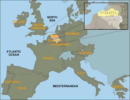
6 Location of Flanders


7 Partners Katholieke Universiteit Leuven 1. Public Management Institute 2. Spatial Applications Division Leuven 3. Interdisciplinary Centre for Law & Information Technology 4. Sociology of Work and Organisation Vrije Universiteit Brussel 5. Department MOSI
8 Main research question What are the technological, legal, economic, sociological and public administrative requirements to further develop an operational Flemish Spatial Data Infrastructure consistent with international standards that is efficient, effective, flexible and feasible?
9 Zero(0)-measurement
10 0-measurement: Aim Kick-off Rather detailed overview on how spatial data and GI-technology is currently tied up with organisational structures in the Flemish public sector. To guide the subsequent disciplinary and cross-disciplinary research efforts to those domains in the Flemish community where problems, obstacles and difficulties are most likely to occur. Primarily result: descriptive data Situation: April May 2008
11 0-measurement: Cont d Description of the current state of SDI practice in order to have a baseline - Analyse (key) organisation that produce, supply or use spatial data - Analyse (key) data flows between organisations - Analyse perceptions of (key) stakeholders in terms of strengths and weaknesses Surveys T = 3 (Final measurement) 4 > T > 0 Intermediate measurement T = 0 (Zero-measurement)
12 0-measurement: Web survey Web survey IVOX Launching: 22 April 2008 (2 reminders: 8 May/15 May) Deadline: 23 May 2008 Sent to 509 organisations (40 federal, 109 Flemish, 10 provincial, 308 municipal, 42 local authorities) List of s of potential participants employed by public authorities that somehow produces or uses spatial data Total: 779 addresses (including personal and general organisational addresses )
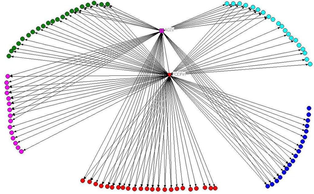
13 0-Measurement: Questionnaire Questionnaire - Simple - Not too long (± 30 minutes) - Disciplinary + Cross-disciplinary questions - Aiming for quantitative (and analysable) results - Facts - Perceptions - Combination of open and closed questions 3 parts 1. Organisational questions (11 questions) 2. Data flow from and to organisations (9 and 6 questions per dataset) 3. Strengths/Weaknesses + Priorities for further development (3 questions)
14 0-measurement: response Total organisations 35% Federal organisations 28% Regional (Flemish) organisations 39% Provincial 8 10 organisations 80% Municipal organisations 34% Local authorities 9 42 organisations 21%

15 Municipal response (May 2008)
16 Regional (Flemish) response Examples: 42 organisations - Department Service for general government policy (DAR) - Agency for GI-Flanders - Agency for International Enterprising - Agency Economy - Flemish authority for Technological Research - Agency for Educational Infrastructure - Department Work en Social Economy - Agency Agriculture and Fishery - Agency Nature and Forest - Department Mobility and Public Works - Department Town and Country Planning and Real Estate
17 Results - Organisational analyses - Network analyses - Strengths/Weaknesses analyses First results, more detailed study needed
 None of both Don t")
18 Geodata producer or user Is your organisation a spatial data user, producer or both? Mainly user Mainly producer Both (user and producer) None of both Don t know
19 GIS use in organisations Percentage employees Zonder GIS Hulpinstrument Geïntegreerd in werkproces Without GIS Tool Integrated in work process Controls employee Stuurt werknemer

20 Exchange policy Documented in an official document Documented in a internal/ Non-official Document Documentation is in progress None, only ad hoc policy None, never received questions to data Don t know

21 Personal data protection policy Does your organisation have an explicit policy for the protection of personal data? Yes, in a document No, but technical/ Organisational security rules No, special rules None, since organisation does not process pers. data Don t know
22 Network analysis Information about data flows as well as organisation In addition, information about the characteristics about the data flows Network analysis as methodology to integrate this all
23 Network Network of GI producers and users in Flanders Organisations = nodes Data flows = links/connections Network contains information about the characteristics of the organisations and flows

24 Input data
25 Analysing networks Characterising network as a whole Characterising individual actors and their relationships within the network Visualising First results (Parcels, Addresses, Roads, Hydrography)
26 Network as a whole Parcels Addresses Roads Hydrography Density 0,0119 0,0062 0,0046 0,0044 Distance 1,312 1,832 1,519 1,709
27 Individual characteristics FOD Financiën AGIV Oost Vlaanderen R-O Vlaanderen Centrality within the parcel network 89,000 62,000 17,000 7,000

28 Parcel Network

29 Parcel Network
30 Parcel network at regional (Flemish) level
31 Parcel network at regional (Flemish) level with links to federal level
32 Parcel network at regional (Flemish) level with links to federal level
33 Parcel network between provinces and municipalities
34 Parcel network between main regional data supplier (Flemish) and municipalities

35 Parcel network between main federal data supplier and municipalities
36
37 Data dissimination: Not efficient Duplication in data transfer No consistent data exchange policy Network analyses
38 GDI-strengths AGIV as the contact point, data manager, supplier 20 High availability of spatial data 18 Strong data-uniformity 15 Accessible for free or to marginal cost 14 Easy data access 11 Direct data access 10 Existence of online-applications 9 Main strengths: AGIV, data richness, uniformity, data access, existing online-applications
39 GDI-weaknesses Too low frequency data actualisation 35 (in particular cadastral files) Too complex/expensive/time-consuming pre-processing 18 Poor data accessibility 14 Too much organisational fragmentation 12 Many problems with geometric data maintenance 12 Too little control on correctness of spatial data 12 No consistent policy (at different adm. levels) 9 Lack of cooperation between federal regional government 9 Main weaknesses: Coordination, Quality, Access, Supply
40 Priority GDI-investment In case you would get 100,000 to be invested in the development of the Flemish SDI, for what would you invest? Links to Priorities of stakeholders for further development of Flemish SDI
41 13. Other activities Better cooperation 11. Other processing structures 10. Strengthen exist. coord. structure 9. Education 8. New applications 7. Network services at coord. organ. 6. Own network services 5. Metadata descrip & maintenance 4. Purchase external datasets 3. Better harmonisation/standaardis. 2. More frequent updates 1 Produce new spatial datasets GDI-investment Euros
42 Thanks for your attention
SWEDISH SDI DEVELOPMENT & IMPLEMENTATION OF INSPIRE
 SWEDISH SDI DEVELOPMENT & IMPLEMENTATION OF INSPIRE Christina Wasström, Lantmäteriet, 801 82 Gävle, Sweden, christina.wasstrom@lm.se ABSTRACT The Swedish Government and Parliament has given Lantmäteriet
Compact guides GISCO. Geographic information system of the Commission
 Compact guides GISCO Geographic information system of the Commission What is GISCO? GISCO, the Geographic Information System of the COmmission, is a permanent service of Eurostat that fulfils the requirements
GIS FOR MAZOWSZE REGION - GENERAL OUTLINE
 GIS FOR MAZOWSZE REGION - GENERAL OUTLINE S. Bialousz 1), K Mączewski 2), E. Janczar 2), K. Osinska-Skotak 1) 1) Warsaw University of Technology, Warsaw, Poland 2) Office of the Surveyor of the Mazowieckie
Exploring GIS Potential for Northwestern Ontario Land Information Ontario
 Exploring GIS Potential for Northwestern Ontario Land Information Ontario May 13, 2015 The LIO Vision LIO Vision: That all geographic information about Ontario is fully integrated and accessible LIO Goal:
INSPIRE Coordination in Germany
 Inter-ministerial Committee for Geo Information INSPIRE Coordination in Germany The federal administrative level Pier-Giorgio Zaccheddu Head of Administration Office Inter-ministerial Committee for Geo
The Swedish National Geodata Strategy and the Geodata Project
 The Swedish National Geodata Strategy and the Geodata Project Ewa Rannestig, Head of NSDI Co-ordination Unit, Lantmäteriet, ewa.rannstig@lm.se Ulf Sandgren, Project Manager Geodata Project, Lantmäteriet,
GIS Building Communities beyond National Borders (Building Successful Spatial Data Infrastructures) Nick Land, ESRI Europe
 Nick Land, ESRI Europe") GIS Building Communities beyond National Borders (Building Successful Spatial Data Infrastructures) Nick Land, ESRI Europe UK worst flooding in the last 60 years 350,000 households without drinking water
GIS Building Communities beyond National Borders (Building Successful Spatial Data Infrastructures) Nick Land, ESRI Europe UK worst flooding in the last 60 years 350,000 households without drinking water
Norwegian spatial data infrastructure supporting disaster risk management Norwegian Mapping Authority
 Norwegian spatial data infrastructure supporting disaster risk management Norwegian Mapping Authority Arvid Lillethun, Norwegian Mapping Authority Land and Poverty 2018 Conference, World Bank 19.-23. March
2007 / 2008 GeoNOVA Secretariat Annual Report
 2007 / 2008 GeoNOVA Secretariat Annual Report Prepared for: Assistant Deputy Minister and Deputy Minister of Service Nova Scotia and Municipal Relations BACKGROUND This report reflects GeoNOVA s ongoing
ADDRESSING THE DATA AND INFORMATION NEEDS FOR GOOD GOVERNANCE, SHARING EXPERIENCES FROM COTE D IVOIRE. 20 April 2016 to 22 April 2016 ADDIS ABABA
 20 April 2016 to 22 April 2016 ADDIS ABABA ADDRESSING THE DATA AND INFORMATION NEEDS FOR GOOD GOVERNANCE, SHARING EXPERIENCES FROM COTE D IVOIRE Dr. Edouard FONH-GBEI Director General of CNTIG, General
Pal NIKOLLI Bashkim IDRIZI Ismail KABASHI Adelajda HALILI THE IMPLEMENTATION OF NATIONAL SPATIAL DATA INFRASTRUCTURE IN ALBANIA
 Pal NIKOLLI Bashkim IDRIZI Ismail KABASHI Adelajda HALILI THE IMPLEMENTATION OF NATIONAL SPATIAL DATA INFRASTRUCTURE IN ALBANIA Overview: Goals of paper Some definitions of SDI NSDI Development NSDI in
Nomination Form. Clearinghouse. New York State Office for Technology. Address: State Capitol-ESP, PO Box
 NASIRE 2001 RECOGNITION AWARDS Recognizing Outstanding Achievement in the Field of Innovative Use of Technology Nomination Form Title of Nomination: Manager/Job Title: Agency: NYS Geographic Information
Land Board, NW Services and SDI Tambet Tiits, FRICS
 Land Board, NW Services and SDI Tambet Tiits, FRICS 07.09.2016 200th anniversary of the Struve Geodetic Arc Friedrich Georg Wilhelm Struve and Carl Friedrich Tenner Struve Geodetic Arc The Struve Geodetic
PART A Project summary
 PART A Project summary A.1 Project identification Project title Project acronym Name of the lead partner organisation in English Specific objective Demonstrattion AF DAF Partner 1.1. Improving innovation
Analys av GIS-användning inom offentlig sektor i Norden
 Analys av GIS-användning inom offentlig sektor i Norden Henning Sten Hansen, Line Hvingel and Lise Schrøder Aalborg Universitet Jönköping, Sweden 30 March 2011 Overview The Danish and Swedish approaches
Ministry of Health and Long-Term Care Geographic Information System (GIS) Strategy An Overview of the Strategy Implementation Plan November 2009
 Strategy An Overview of the Strategy Implementation Plan November 2009") Ministry of Health and Long-Term Care Geographic Information System (GIS) Strategy An Overview of the Strategy Implementation Plan November 2009 John Hill, Health Analytics Branch Health System Information
Ministry of Health and Long-Term Care Geographic Information System (GIS) Strategy An Overview of the Strategy Implementation Plan November 2009 John Hill, Health Analytics Branch Health System Information
SDI in Lombardia (Italy(
 SDI in Lombardia (Italy( Italy) Andrea Piccin European SDI Best Practice Awards 2009 - Learning from Best Practices Turin, 26th and 27th November 2009 Lombardia, in Italy, is 4 th Region for territorial
The ESPON Programme. Goals Main Results Future
 The ESPON Programme Goals Main Results Future Structure 1. Goals Objectives and expectations Participation, organisation and networking Themes addressed in the applied research undertaken in ESPON projects
Appropriation Directions for 2007
 INSPIRE in Sweden An Important Part of the National Geodata Strategy Monica Lagerqvist Nilsson Appropriation Directions for 2007 A commission to investigate the necessity to adjust the Swedish legislation
Brazil Paper for the. Second Preparatory Meeting of the Proposed United Nations Committee of Experts on Global Geographic Information Management
 Brazil Paper for the Second Preparatory Meeting of the Proposed United Nations Committee of Experts on Global Geographic Information Management on Data Integration Introduction The quick development of
INSPIRE in Sweden.
 INSPIRE in Sweden Swedish National Data Service Established 2008. SND is a service organisation for Swedish research within the Humanities, Social Sciences and Medicine. SND is the Swedish node in an international
Between legislation and consensus how do we INSPIRE Denmark?
 Between legislation and consensus how do we INSPIRE Denmark? Olav Eggers Spatial Data Infrastructure Division Danish Ministry of the Environment National Survey and Cadastre (KMS), Denmark INSPIRE Contact
THE ROLE OF GEOSPATIAL AT THE WORLD BANK
 THE ROLE OF GEOSPATIAL AT THE WORLD BANK INSPIRE Conference Barcelona, Spain September 26, 2016 Kathrine Kelm Senior Land Administration Specialist Global Land and Geospatial Unit The World Bank Group
The Gers Chamber of Commerce and Industry has been one of the first key-players to introduce geomatics in France in 1998 thanks to European projects
 1 2 Good afternoon, The objective of my presentation is to describe how a region, as well as all french regions, are organized currently at regional level in order to implement the INSPIRE directive. I
Land Use in the context of sustainable, smart and inclusive growth
 Land Use in the context of sustainable, smart and inclusive growth François Salgé Ministry of sustainable development France facilitator EUROGI vice president AFIGéO board member 1 Introduction e-content+
The Role of Urban Planning and Local SDI Development in a Spatially Enabled Government. Faisal Qureishi
 The Role of Urban Planning and Local SDI Development in a Spatially Enabled Government Faisal Qureishi 1 Introduction A continuous increase in world population combined with limited resources has lead
Realizing benefits of Spatial Data Infrastructure A user s perspective from Environment Agency - Abu Dhabi
 Realizing benefits of Spatial Data Infrastructure A user s perspective from Environment Agency - Abu Dhabi Anil Kumar Director, Environment Information Management 26 April 2012 Geospatial World Forum,
Ministry of ICT of I.R.IRAN
 The ECO 8/6 mill km 2 10 Slamic countries ~330 mill people Oil, Gas, Industries,Tourism 2 Issue transformation in last decade Problem solving needs more integrated approach More interaction &complexity
Technical Framework Methodology as a core of building up the NSDI NSDI Implementation Specifics in Serbia
 Technical Framework Methodology as a core of building up the NSDI NSDI Implementation Specifics in Serbia Luka Jovičić SDI Consultant@ Gramont Ltd. Aleksandar Dedić RGA NSDI department Dragica Pajić RGA
Emerging Trends in Institutional Arrangements Europe - Finland
 Emerging Trends in Institutional Arrangements Europe - Finland Arvo Kokkonen Deputy Director General National Land Survey of Finland 1 Contents Facts about Finland National Land Survey of Finland European
Governance and performance of open spatial data policies in the context of INSPIRE
 Governance and performance of open spatial data policies in the context of INSPIRE Dr. Glenn Vancauwenberghe Delft University of Technology Dr. ir. Bastiaan van Loenen Delft University of Technology 1
Infrastructure for Spatial Information in Europe (INSPIRE)
") Infrastructure for Spatial Information in Europe (INSPIRE) 2011 GISCO Working Party 8-9.3.2012 INSPIRE is about improving access to spatial information: the environment doesn t stop at borders EU Geoportal
Infrastructure for Spatial Information in Europe (INSPIRE) 2011 GISCO Working Party 8-9.3.2012 INSPIRE is about improving access to spatial information: the environment doesn t stop at borders EU Geoportal
The Integrated Ge spatial Information Framework to the strengthening of NSDI, Mongolia
 Young Geospatial Professionals Summit 21 NOV 2018 The Integrated Ge spatial Information Framework to the strengthening of NSDI, Mongolia BAYARMAA ENKHTUR Geospatial information and technology department
Economic Benefit Study on Value of Spatial Information Australian Experience
 Economic Benefit Study on Value of Spatial Information Australian Experience Dr Zaffar Sadiq Mohamed-Ghouse Director, International Relations Cooperative Research Centre for Spatial Information zsadiq@crcsi.com.au
The state-of-the-art of the Finnish SDI. Arctic SDI WG Meeting
 The state-of-the-art of the Finnish SDI Arctic SDI WG Meeting Moscow 8.9.2011 Esa Tiainen Development Centre 1 NATIONAL LAND SURVEY DOWN TO EARTH Contents Legal framework Coordination structure Network
INSPIRE Basics. Vlado Cetl European Commission Joint Research Centre. https://ec.europa.eu/jrc/
 INSPIRE Basics Vlado Cetl European Commission Joint Research Centre https://ec.europa.eu/jrc/ Serving society Stimulating innovation Supporting legislation Outline SDI? Why European SDI? INSPIRE Policy
EuroGeographics & INSPIRE. Nick Land, Executive Director of EuroGeographics
 EuroGeographics & INSPIRE Nick Land, Executive Director of EuroGeographics EuroGeographics A growing association 49 Members, 42 countries Topographic mapping, cadastre, land registry + Networked organisation
Demonstration of a local SDI solution with several stakeholders in pilot areas in line with EU best practices
 EU Twinning project for the Agency of Land Relations and Cadaster (ALRC)- Organization, Streamlining and Computerization Process in Mapping in the Republic of Moldova. Demonstration of a local SDI solution
a national geological survey perspective François ROBIDA BRGM (French Geological Survey)
") a national geological survey perspective François ROBIDA BRGM (French Geological Survey) Pre-Conference Seminar on Socio-Economic Value of Geospatial for National and Regional Development 21 August 2017,
a national geological survey perspective François ROBIDA BRGM (French Geological Survey) Pre-Conference Seminar on Socio-Economic Value of Geospatial for National and Regional Development 21 August 2017,
NSDI as a tool for Secure land tenure
 NSDI as a tool for Secure land tenure General Overview To look at the progress in SDI development and its application in policy formulation and impact on land tenure. INTEGRATION OF INFORMATION POLICIES
Building a national spatial data infrastructure. Thorben Hansen, Head of Division Danish Agency for Data Supply and Efficiency
 Building a national spatial data infrastructure Thorben Hansen, Head of Division Danish Agency for Data Supply and Efficiency About Spatial Data Infrastructure Spatial data come from many sources and is
INSPIRE - A Legal framework for environmental and land administration data in Europe
 INSPIRE - A Legal framework for environmental and land administration data in Europe Dr. Markus Seifert Bavarian Administration for Surveying and Cadastre Head of the SDI Office Bavaria Delegate of Germany
Paloma Abad LÓPEZ, Emilio; SÁNCHEZ, Alejandra; RODRÍGUEZ, Antonio F; SOTERES, Carolina. September 17
 Paloma Abad LÓPEZ, Emilio; SÁNCHEZ, Alejandra; RODRÍGUEZ, Antonio F; SOTERES, Carolina 1 We know Directive 2007/2/EC requires Member States to monitor the implementation and use of their infrastructures
Sustainable and Harmonised Development for Smart Cities The Role of Geospatial Reference Data. Peter Creuzer
 Sustainable and Harmonised Development for Smart Cities The Role of Geospatial Reference Data Peter Creuzer 1. Introduction - Smart Cities and Geodata 2. Geodata in Germany 3. Examples 4. Data and Service
Project based approach developing National Spatial Data Infrastructure in Lithuania
 Project based approach developing National Spatial Data Infrastructure in Lithuania National Land Service under the Ministry of Agriculture of The Republic of Lithuania Cadastres & Geodesy Department Director
Status of implementation of the INSPIRE Directive 2016 Country Fiches. COUNTRY FICHE Malta
 Status of implementation of the INSPIRE Directive 2016 Country Fiches COUNTRY FICHE Malta Introduction... 1 1. State of Play... 2 1.1 Coordination... 2 1.2 Functioning and coordination of the infrastructure...
Interoperability of Spatial Planning Data
 INSPIRE Conference 2010, Krakow, Poland Interoperability of Spatial Planning Data European Network of Best Practices for Interoperability of Spatial Planning Information Tomas Mildorf mildorf@centrum.cz
INSPIRE in Sweden - an Important Part of the National Geodata Strategy
 INSPIRE in Sweden - an Important Part of the National Geodata Strategy Ewa RANNESTIG and Monica LAGERQVIST NILSSON, Sweden Key words: National Geodata Strategy, National Infrastructure for Spatial Information,
Status of implementation of the INSPIRE Directive 2016 Country Fiches. COUNTRY FICHE Netherlands
 Status of implementation of the INSPIRE Directive 2016 Country Fiches COUNTRY FICHE Netherlands Introduction... 1 1. State of Play... 2 1.1 Coordination... 2 1.2 Functioning and coordination of the infrastructure...
Status of implementation of the INSPIRE Directive 2016 Country Fiches. COUNTRY FICHE Croatia
 Status of implementation of the INSPIRE Directive 2016 Country Fiches COUNTRY FICHE Croatia Introduction... 1 1. State of Play... 2 1.1 Coordination... 2 1.2 Functioning and coordination of the infrastructure...
Open Data meets Big Data
 Open Data meets Big Data Max Craglia, Sven Schade, Anders Friis European Commission Joint Research Centre www.jrc.ec.europa.eu Serving society Stimulating innovation Supporting legislation JRC is Technical
SDI Development in Georgia. Mari Khardziani Head of International Relations Unit National Agency of Public Registry
 SDI Development in Georgia Mari Khardziani Head of International Relations Unit National Agency of Public Registry Kehl, Germany September 5, 2017 2 National Agency of Public Registry Legal Entity of Public
Establishing the National Spatial Data Infrastructure (NSDI) for Norway a joint effort by many stakeholders SPATIAL DATA FOR BENEFIT OF THE SOCIETY
 for Norway a joint effort by many stakeholders SPATIAL DATA FOR BENEFIT OF THE SOCIETY") Establishing the National Spatial Data Infrastructure (NSDI) for Norway a joint effort by many stakeholders SPATIAL DATA FOR THE BENEFIT OF SOCIETY OUTLINE Political background Norway digital - The Norwegian
Establishing the National Spatial Data Infrastructure (NSDI) for Norway a joint effort by many stakeholders SPATIAL DATA FOR THE BENEFIT OF SOCIETY OUTLINE Political background Norway digital - The Norwegian
INSPIRATION results and benefits for the Agency for Real Estate Cadastre
 JOINT RESEARCH CENTER - E&I WORKSHOP INSPIRATION results and benefits for the Agency for Real Estate Cadastre Sonja Dimova, state advisor AGENCY FOR REAL ESTATE CADASTRE REPUBLIC OF MACEDONIA Wednesday,
The Governance of Land Use
 The planning system The Governance of Land Use United Kingdom Levels of government and their responsibilities The United Kingdom is a unitary state with three devolved governments in Northern Ireland,
SDI-Challenges European perspective
 THE HIGH LEVEL FORUM ON GLOBAL GEOSPATIAL INFORMATION MANAGEMENT Seoul, Republic of Korea, 24-26 October 2011 Session 1: Challenges in geospatial policy formation and institutional arrangements SDI-Challenges
IRDAT Fvg, evolving a regional Spatial Data Infrastructure according to INSPIRE
 IRDAT Fvg, evolving a regional Spatial Data Infrastructure according to INSPIRE Tutti i diritti riservati. Proprietà INSIEL SpA. A. Benvenuti, A. Chiarandini Insiel (Italy) M. Lunardis - Friuli Venezia
ISO Series Standards in a Model Driven Architecture for Landmanagement. Jürgen Ebbinghaus, AED-SICAD
 ISO 19100 Series Standards in a Model Driven Architecture for Landmanagement Jürgen Ebbinghaus, AED-SICAD 29.10.2003 The Company 100% SIEMENS PTD SIEMENS Business Services Shareholder & Strategic Business
Alps Results from the ESPON Project. Common spatial perspectives for the Alpine area. Towards a common vision
 Results from the ESPON Project Alps 2050 Common spatial perspectives for the Alpine area. Towards a common vision Tobias Chilla, University of Erlangen Cooperation Alps 2020+ 1 & 2 October 2018 Salzburg
Data Origin. Ron van Lammeren CGI-GIRS 0910
 Data Origin Ron van Lammeren CGI-GIRS 0910 How to obtain geodata? Geo data initiative Executive Order 12906, "Coordinating Geographic Data Acquisition and Access: The National Spatial Data Infrastructure,"
Spatial Data Infrastructure for Prosperous Nepal
 Spatial Data Infrastructure for Prosperous Nepal Rabin K. SHARMA and Babu Ram ACHARYA, Nepal Key words: Metadata, Clearinghouse, Sustainable development, Good governance, SUMMARY This paper examines the
ATLAS OF INSPIRE IMPLEMENTATION. An Inventory of Experiences, Successes And Headaches of European National Mapping Agencies
 ATLAS OF INSPIRE IMPLEMENTATION An Inventory of Experiences, Successes And Headaches of European National Mapping Agencies Walter T. de Vries (Joep Crompvoets, Jantien Stoter, Ingrid Vanden Berghe) 23
The FIG - Questionnaire on NSDI
 The FIG - Questionnaire on NSDI Bernd Teichert University of Applied Sciences Dresden, Germany Contents NSDI - Definition Com. 3 - Brainstorming in Prague Canberra Implications and Conclusions The SDI
Status of implementation of the INSPIRE Directive 2016 Country Fiches. COUNTRY FICHE Finland
 Status of implementation of the INSPIRE Directive 2016 Country Fiches COUNTRY FICHE Finland Introduction... 1 1. State of Play... 2 1.1 Coordination... 2 1.2 Functioning and coordination of the infrastructure...
Adding value to Copernicus services with member states reference data
 www.eurogeographics.org Adding value to Copernicus services with member states reference data Neil Sutherland neil.sutherland@os.uk GIS in the EU 10 November 2016 Copyright 2016 EuroGeographics 61 member
Status of implementation of the INSPIRE Directive 2016 Country Fiches. COUNTRY FICHE Italy
 Status of implementation of the INSPIRE Directive 2016 Country Fiches COUNTRY FICHE Italy Introduction... 1 1. State of Play... 2 1.1 Coordination... 2 1.2 Functioning and coordination of the infrastructure...
Introduction. Elevation Data Strategy. Status and Next Steps
 1 2 Introduction Elevation Data Strategy Status and Next Steps 3 Canada is the 2nd largest country in the world - 9.9 million sq km Surrounded by 3 oceans with 202 000 km of coastline Population over 35
Data Origin. How to obtain geodata? Ron van Lammeren CGI-GIRS 0910
 Data Origin How to obtain geodata? Ron van Lammeren CGI-GIRS 0910 Spatial Data interest Improvement of policy making. ± 90% of all information used by government has spatial characteristics SPATIAL INFORMATION
Status of implementation of the INSPIRE Directive 2016 Country Fiches. COUNTRY FICHE Czech Republic
 Status of implementation of the INSPIRE Directive 2016 Country Fiches COUNTRY FICHE Czech Republic Introduction... 1 1. State of Play... 2 1.1 Coordination... 2 1.2 Functioning and coordination of the
National Cartographic Center
 National Cartographic Center NCC activities and accomplishments Activities of national organizations, institutions and universities in field of geomatics Large scale maps Medium scale maps Small scale
NATIONAL BENEFITS OF INSPIRE IMPLEMENTATION THE REAL LIFE USE CASES
 NATIONAL BENEFITS OF INSPIRE IMPLEMENTATION THE REAL LIFE USE CASES Andrius Balciunas, SE GIS Centras, a.balciunas@gis centras.lt Evaldas Rozanskas, SE GIS Centras, e.rozanskas@gis centras.lt INSPIRE conference
Policies towards SDI development and implementation in the Americas
 Policies towards SDI development and implementation in the Americas Valéria Oliveira Henrique de Araújo Executive Secretary of CP-IDEA Brazilian Institute of Geography and Statistics - IBGE Geospatial
Urban Climate Resilience
 Urban Climate Resilience in Southeast Asia Partnership Project Introduction Planning for climate change is a daunting challenge for governments in the Mekong Region. Limited capacity at the municipal level,
Implementation of Inspire in Denmark - How we get it flying! Olav Eggers National Survey & Cadastre -Denmark
 Implementation of Inspire in Denmark - How we get it flying! Olav Eggers oe@kms.dk National Survey & Cadastre -Denmark Introduction Overview Infrastructure for Spatial Information Act National Survey and
Local Spatial Data Infrastructure, a Solid Base for Sustainable Land Management in Germany
 Local Spatial Data Infrastructure, a Solid Base for Sustainable Land Management in Germany FIG Commission 3 Workshop and Commission 3 Annual Meeting The Empowerment of Local Authorities: Spatial Information
EuroSDR (European Spatial Data Research)
") EuroSDR (European Spatial Data Research) ROLLING RESEARCH PLAN 2015-2018 EuroSDR Secretariat Public Governance Institute KU Leuven Parkstraat 45 bus 3609 3000 Leuven Belgium Tel.: +32 16 32 31 80 Fax:
EuroSDR (European Spatial Data Research) ROLLING RESEARCH PLAN 2015-2018 EuroSDR Secretariat Public Governance Institute KU Leuven Parkstraat 45 bus 3609 3000 Leuven Belgium Tel.: +32 16 32 31 80 Fax:
Lombardy Region Territorial Context and Planning Structures
 Lombardy Region Territorial Context and Planning Structures Carlo Palazzoli RUMORE project manager carlo_palazzoli@regione.lombardia.it 15th May 2018 / RUMORE Third Partner Meeting Lombardy Region in Europe
The Danish Maritime Spatial Data Infrastructure (MSDI) Geodata of the Sea
 Geodata of the Sea") MSDI/MSP The Danish Maritime Spatial Data Infrastructure (MSDI) Geodata of the Sea Components of an infrastructure: DATA - metadata, datasets FUNCTIONALITY - spatial data services, web services and other
MSDI/MSP The Danish Maritime Spatial Data Infrastructure (MSDI) Geodata of the Sea Components of an infrastructure: DATA - metadata, datasets FUNCTIONALITY - spatial data services, web services and other
Spatially Enabled Society
 International Seminar on Land Administration Trends and Issues in Asia and the Pacific Region Spatially Enabled Society Abbas Rajabifard Vice Chair PCGIAP-WG3 Vice-President (President Elect), GSDI Association
Report on the establishment of UN GGIM: Europe Item 14. 4th session of the Committee of Experts on UN-GGIM
 Report on the establishment of UN GGIM: Europe Item 14 1 Why regional European committees of UN GGIM? In the ECOSOC resolution 2011/24 on the UN GGIM: Emphasizes the importance of promoting national, regional
Global Geospatial Information Management Country Report Finland. Submitted by Director General Jarmo Ratia, National Land Survey
 Global Geospatial Information Management Country Report Finland Submitted by Director General Jarmo Ratia, National Land Survey Global Geospatial Information Management Country Report Finland Background
The Governance of Land Use
 The planning system Levels of government and their responsibilities The Governance of Land Use COUNTRY FACT SHEET NORWAY Norway is a unitary state with three levels of government; the national level, 19
Turkey s National SDI Implementation
 Onur PAŞAOĞULLARI Head of Department Turkey s National SDI Implementation Presentation Plan NSDI Background General Directorate of Geographic Information Systems NSDI Project INSPIRE Directive Urban Information
Georeferencing and Satellite Image Support: Lessons learned, Challenges and Opportunities
 Georeferencing and Satellite Image Support: Lessons learned, Challenges and Opportunities Shirish Ravan shirish.ravan@unoosa.org UN-SPIDER United Nations Office for Outer Space Affairs (UNOOSA) UN-SPIDER
Status of implementation of the INSPIRE Directive 2016 Country Fiches. COUNTRY FICHE Ireland
 Status of implementation of the INSPIRE Directive 2016 Country Fiches COUNTRY FICHE Ireland Introduction... 1 1. State of Play... 2 1.1 Coordination... 2 1.2 Functioning and coordination of the infrastructure...
Summary. Recommendations on the Fifth Policy Document on Spatial Planning September 2001
 Summary Recommendations on the Fifth Policy Document on Spatial Planning September 2001 2 Introduction In December 2000 the Dutch Cabinet issued Part 1 of the Fifth National Policy Document on Spatial
Spatial Data Infrastructure Concepts and Components. Douglas Nebert U.S. Federal Geographic Data Committee Secretariat
 Spatial Data Infrastructure Concepts and Components Douglas Nebert U.S. Federal Geographic Data Committee Secretariat August 2009 What is a Spatial Data Infrastructure (SDI)? The SDI provides a basis for
UN-GGIM: Strengthening Geospatial Capability
 Fifth Plenary Meeting of UN-GGIM: Europe Brussels, 6-7 June 2018 UN-GGIM: Strengthening Geospatial Capability Walking the talk to leave no one behind Greg Scott, UN-GGIM Secretariat Environmental Statistics
RETA 6422: Mainstreaming Environment for Poverty Reduction Category 2 Subproject
 RETA 6422: Mainstreaming Environment for Poverty Reduction Category 2 Subproject A. Basic Data 1. Subproject Title: Poverty-Environment Mapping to Support Decision Making 2. Country Director: Adrian Ruthenberg
REGIONAL SDI DEVELOPMENT
 REGIONAL SDI DEVELOPMENT Abbas Rajabifard 1 and Ian P. Williamson 2 1 Deputy Director and Senior Research Fellow Email: abbas.r@unimelb.edu.au 2 Director, Professor of Surveying and Land Information, Email:
Country Case Studies Norway- The Norwegian national spatial data infrastructure improve risk management and of disaster resilience
 Country Case Studies Norway- The Norwegian national spatial data infrastructure improve risk management and of disaster resilience Arvid Lillethun Norwegian Mapping Authority Land Mapping Division arvid.lillethun@kartverket.no
Plan4all (econtentplus project)
") Plan4all (econtentplus project) Karel CHARVAT 1, Tomáš MILDORF 2 1 Help service remote sensing, Ltd., Černoleská 1600, 256 01 Benešov u Prahy, Czech Republic charvat@bnhelp.cz 2 Department of Mathematics
Plan4all (econtentplus project) Karel CHARVAT 1, Tomáš MILDORF 2 1 Help service remote sensing, Ltd., Černoleská 1600, 256 01 Benešov u Prahy, Czech Republic charvat@bnhelp.cz 2 Department of Mathematics
NGO potential as a stakeholder within processes of developing the NSDI
 and 7th Cartography and Geoinformation Conference NGO potential as a stakeholder within processes of developing the NSDI Luka Jovičić, MSc. Industrial Engineering representative market NGO status needs
INDONESIA S S UPDATE: GEOSPATIAL INFORMATION FOR SUSTAINABLE DEVELOPMENT RELATED TO INA SDI Dr. Asep Karsidi, M.Sc
 INDONESIA S S UPDATE: GEOSPATIAL INFORMATION FOR SUSTAINABLE DEVELOPMENT RELATED TO INA SDI Dr. Asep Karsidi, M.Sc GEOSPATIAL INFORMATION AGENCY 08 August, 2012 OUTLINE 1. Transformation Bakosurtanal into
UC Berkeley International Conference on GIScience Short Paper Proceedings
 UC Berkeley International Conference on GIScience Short Paper Proceedings Title Managing and Updating Geographical Data: Issues Along the Hierarchical Chain? Permalink https://escholarship.org/uc/item/6pd1j5rs
Geospatial Policy Development and Institutional Arrangements *
 HIGH LEVEL FORUM ON GLOBAL GEOSPATIAL MANAGEMENT INFORMATION WORKING PAPER No. 13 First Forum Seoul, Republic of Korea, 24-26 October 2011 Geospatial Policy Development and Institutional Arrangements *
GIS Geographical Information Systems. GIS Management
 GIS Geographical Information Systems GIS Management Difficulties on establishing a GIS Funding GIS Determining Project Standards Data Gathering Map Development Recruiting GIS Professionals Educating Staff
Funding models for institutional arrangements in the context of a national SDI: the case of Chile
 Funding models for institutional arrangements in the context of a national SDI: the case of Chile Alvaro Monett Hernández Executive Secretary SNIT Chile Vice-President UN-GGIM Américas Fifth Meeting of
Towards Reliable Spatial Database of Informal Areas in Greater Cairo Region
 KEYWORDS informal areas, unreliable spatial data, spatial data collecting, capacity building SUMMARY The uncontrolled and rapid increase of Egypt s cities is a major problem of the country. More than the
OPEN GOVERNMENT - BENEFITS OF INSPIRE IN THE PUBLIC SECTOR
 Brussels, 04th March 2013 - Daniela Hogrebe and André Caffier from GDI-DE 1 OPEN GOVERNMENT - BENEFITS OF INSPIRE IN THE PUBLIC SECTOR Powered by INSPIRE Open Government 2 SDI is a fundament of transparent