7th FIG Regional Conference Spatial Data Serving People: Land Governance and the Environment - Building the Capacity
|
|
|
- Dayna O’Neal’
- 6 years ago
- Views:
Transcription

1 7th FIG Regional Conference Spatial Data Serving People: Land Governance and the Environment - Building the Capacity Hanoi, Vietnam, October TS 3A - SDI in Support of Urban Management Electronic Atlas for Land management in Hanoi By MSc.Quy BUI NGOC, Prof.Dr Cam Van NGUYEN Electronic Atlas for Land management in Hanoi - Electronic atlas is one of the tool for land management work, - Electronic atlas can store data in digital format, manage data by a database management system will allow to execute the statistic data rapidly, to identify geographical coordinates, distance, perimeter, land cell area and other necessary information. - Networking electronic atlas also allows to access and search for objects with given parameters. This article addresses the use of mapping, GIS and Multimedia technologies to establish the electronic atlas supporting land management in Hanoi. It is the experiments of establishing and uploading electronic atlas to Web. 1
2 Expanded Hanoi faces challenges in land management - In 2008, Hanoi city was expanded its administrative border. -The increase of 3 times in area and population. With a relatively large area of 3,300 km2, Hanoi will have great difficulties in land management. That is why the construction of an Electronic Atlas supporting land management in Hanoi city is a practical task, which can solve some critical problems in managing Hanoi s land today. Electronic Atlas for Land management in Hanoi 2

3 1.2. Objectives for Building an Electronic Atlas for Hanoi Land Management. The Electronic Atlas for Hanoi land management is built to meet the following objectives and tasks: Representing all information on cadastral, current land use and land use planning of Hanoi at 3-level: City, Districts, Communes and Town. Providing tools to facilitate quick information search Supporting format for use on computers and on the networks LAN, WAN, of the Hanoi city. Offering data that can be downloaded, manipulated, and mapped to facilitate decision making process. Electronic Atlas for Land management in Hanoi Case study: φ=20 o 34 N to 21 o 23 N, λ =105 o 17 E to 106 o 02 E 3
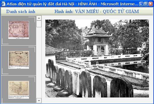
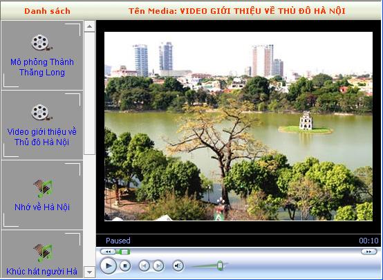
4 Atlas s structure - Electronic Atlas for land management in Hanoi consists of three themes: Cadastral, land use and land use planning. - Each theme has one map for all Hanoi city and 30 maps for every district. - The maps are managed by administration unit and by theme. - Maps are notes with text document, image, picture and information about commune and districts. The Atlas has two main pages: 1. Home page: is representation page with the name of Atlas, use interface and the main link to the content of atlas. 2. Map page: shows the map and tool for manipulating function. From these main pages, the Atlas allows to open many windows such as map window, legend window, window for multimedia elements and search information The Atlas is built on an open architecture; manager can add or reduce subjects, maps or update maps database regularly. Electronic Atlas for Land management in Hanoi Atlas Building Diagram Preparing Layout design Analyze, design and create Database. Interface building Modules creating, application programing Maps Database Attributes database Multimedia database. Directories accessing Design the Menu, home page and content layout Product assembling and finishing (Check and correct) Test Package 4
5 Map Database for Land Management in Hanoi. - Hanoi Electronic Atlas includes 3 map groups: cadastral, current land use and land use planning of all administrative units in the city. - All maps are edited by MapInfo software following the guidance on mapping technology and land database system of Ministry of Natural Resources and Environment, Viet Nam. Electronic Atlas for Land management in Hanoi Data The diagram of data storaged in the Atlas T Huyen1 Huyen2,... Huyen29 CD1 CD2 CD3 CD1 CD2 CD3 CD1 CD2 CD3 CD1 CD2 CD3 The files of map, workspaces file of CD1, legend The files of map, workspaces file of CD1, legend The files of map, workspaces file of CD2, legend The files of map, workspaces file of CD3, legend X1 X2,... Xi X1 X2,... Xi X1 X2,... Xi CD1 CD2 CD3 CD1 CD2 CD3 CD1 CD2 CD3 The files of map, workspaces file of CD1, legend The files of map, workspaces file of CD2, legend The files of map, workspaces file of CD1, legend - Video (the files videoclip) - Nhac (the songs) - Anh (the pictures) - TM (include guide file) - Video (the files videoclip) - Nhac (the songs) - Anh (the pictures) - TM (include guide file) -CSDL_TM.mdb -The Folder, Libray and web component files 5
6 All the maps are edited and stored in a standard format and structured before imported into the Atlas s database, for example, each map is stored in 1 folder. In each folder will contain: + The map files. Tab (classes of maps), accompanied by the configuration file of each class (.map,.id,.dat,.dbf). + One workspace file formatted as *. mws file and the name for all the map is bando.mws The diagram of data storage in the Atlas is shown in Figure 2, in which: - Data (the folder name to store the group map data file and other attached documents) - T: the directory for store city level data - Huyen1, Huyen2... Huyen29: Folder contains district level data. - X1, X2... Xi: Folder contains data of communes. - CD1 (Cadastral maps). - CD2 (Current land use maps) - CD3 (Land use planning maps) Electronic Atlas for Land management in Hanoi Displaying methods and data management in electronic atlas 1. Use programming tool and develop Visual studio application of Microsoft. 2. Use map displaying library of Mapxtreme provided by Mapinfo Coorporation. 3. Arrange data in standard data of Mapinfo ( map files are formed in format:*.tab,.map,.id,.dat)and arranged in individual directories/folders (CD1, CD2) for each map s page. 4. Multimedia data such as films, sound, images on each map s page are storaged in folder Photos in each category s directories 5. Create a database file such as Access format to store Menu s structure and the links to files contain information about texts, sound, films, images of each map s page. 6. Pack and create file setup. 6
7 Ideas for organizing/arranging information for Electronic Atlas for Land management in Hanoi Organizing/arranging information for each electronic map page,each map page is imported objects information, attributes. Every administrative unit on each map page uses common menu and link with map management function, legend view function, display and view multimedia components function. Mapping system is designed and used common tools ( such as: Zoom in, zoom out, move, access information, distance measurement ) Each map is stored in a directory and placed in a common folder: Data. Besides, we create database files in Access format to store menu s structure and the link to map files, texts, films, sound, images on each map s page. Electronic Atlas for Land management in Hanoi The Publish for Electronic Atlas for Land anagement in Hanoi on the internet + Publish atlas onto the Internet based on Client/Server system. + Electronic Atlas allow manager to update and add data for atlas. 7
8 8

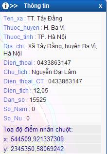
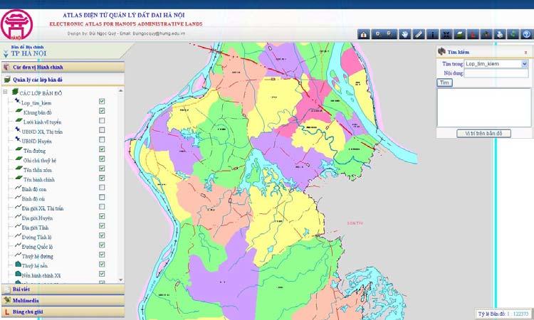
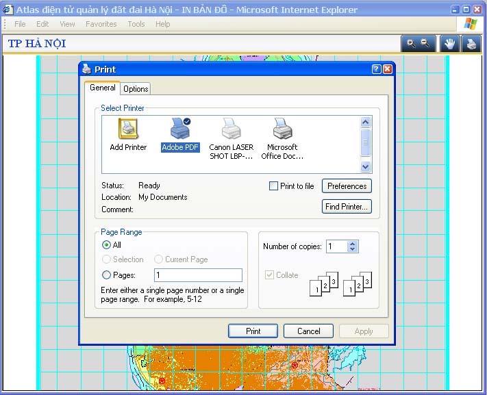
9 Electronic Atlas for Land management in Hanoi Back home Zoom out Distance Center Open Legend Refresh map Zoom in Pan Information Layer control Search Print Help 9


10 Menu b n å vµ c c yõu tè kh c C c trang b n å -îc tæ chøc mét c ch logic trong một menu gióp tra cøu b n å mét c ch hö thèng vµ tiön lîi Menu b n å vµ c c yõu tè kh c 10


11 Menu b n å vµ c c yõu tè kh c Go to the map by link function 11


12 The functions of Electronic Atlas for Land management in Hanoi The maps of Atlas has design with multiscale and multilevels 12


13 The functions of Electronic Atlas for Land management in Hanoi The functions of Electronic Atlas for Land management in Hanoi 13

14 The functions of Electronic Atlas for Land management in Hanoi The functions of Electronic Atlas for Land management in Hanoi 14

15 The functions of Electronic Atlas for Land management in Hanoi The functions of Electronic Atlas for Land management in Hanoi 15


16 The functions of Electronic Atlas for Land management in Hanoi The functions of Electronic Atlas for Land management in Hanoi 16

17 The functions of Electronic Atlas for Land management in Hanoi The functions of Electronic Atlas for Land management in Hanoi 17


18 The functions of Electronic Atlas for Land management in Hanoi The functions of Electronic Atlas for Land management in Hanoi 18

19 - Hanoi Electronic Atlas for land management can run completely and stably on many current Windows systems such as Windows XP, Windows NT and can upload on-line through communication networks. - Its structure and content meet most requirements of the traditional Atlas and have more advantage. It can provide functions to query and display attribute information; display the map in multi scales and multi layers... The tool set is designed with many diverse tasks to help the user manipulate the map and find information easily. - With this Atlas, Hanoi people now can easily get information on land use and land planning. - Atlas needs to be built to follow the Open GIS standards so that the task to upgrade and update information of the map will be more convenient. 19
Model development for WebAtlas system applying in administration management.
 Model development for WebAtlas system applying in administration management. Bui Ngoc Quy, Vo Ngọc Dung, Nguyen Danh Duc, University of mining and geology, Viet Nam Key words: Webatlas, Web Map, Electronic
Model development for web - atlas system applying in administration management
 VNU Journal of Science, Earth Sciences 28 (2012) 29-36 Model development for web - atlas system applying in administration management Bui Ngoc Quy* Ha Noi University of Mining and Geology, Dong Ngac, Tu
Write a report (6-7 pages, double space) on some examples of Internet Applications. You can choose only ONE of the following application areas:
 on some examples of Internet Applications. You can choose only ONE of the following application areas:") UPR 6905 Internet GIS Homework 1 Yong Hong Guo September 9, 2008 Write a report (6-7 pages, double space) on some examples of Internet Applications. You can choose only ONE of the following application
UPR 6905 Internet GIS Homework 1 Yong Hong Guo September 9, 2008 Write a report (6-7 pages, double space) on some examples of Internet Applications. You can choose only ONE of the following application
GIS Software. Evolution of GIS Software
 GIS Software The geoprocessing engines of GIS Major functions Collect, store, mange, query, analyze and present Key terms Program collections of instructions to manipulate data Package integrated collection
GIS Supports to Economic and Social Development
 GIS Supports to Economic and Social Development Dang Van Duc and Le Quoc Hung Institute of Information Technology 18, Hoang Quoc Viet Rd., Cau Giay Dist., Hanoi, Vietnam Email: dvduc@ioit.ncst.ac.vn; lqhung@ioit.ncst.ac.vn
The Application of 3D Web GIS In Land Administration - 3D Building Model System
 The Application of 3D Web GIS In Land Administration - 3D Building Model System Hui-Wen Chen *, Wen-Yuan Ku *, Lan-Kun Chung *, Tien-Yin Chou *, Li-Min Yi2 ** * Feng Chia University, Taiwan, ** Land Department
NR402 GIS Applications in Natural Resources
 NR402 GIS Applications in Natural Resources Lesson 1 Introduction to GIS Eva Strand, University of Idaho Map of the Pacific Northwest from http://www.or.blm.gov/gis/ Welcome to NR402 GIS Applications in
Transactions on Information and Communications Technologies vol 18, 1998 WIT Press, ISSN
 GIS in the process of road design N.C. Babic, D. Rebolj & L. Hanzic Civil Engineering Informatics Center, University ofmaribor, Faculty of Civil Engineering, Smetanova 17, 2000 Maribor, Slovenia. E-mail:
Personal Field Data Collection by UM-FieldGIS (Integration of Google Map API to Mobile GIS)
") Personal Field Data Collection by UM-FieldGIS (Integration of Google Map API to Mobile GIS) Ko Ko Lwin*. Yuji MURAYAMA* *Division of Spatial Information Science Graduate School of Life and Environmental
Personal Field Data Collection by UM-FieldGIS (Integration of Google Map API to Mobile GIS) Ko Ko Lwin*. Yuji MURAYAMA* *Division of Spatial Information Science Graduate School of Life and Environmental
Learning ArcGIS: Introduction to ArcCatalog 10.1
 Learning ArcGIS: Introduction to ArcCatalog 10.1 Estimated Time: 1 Hour Information systems help us to manage what we know by making it easier to organize, access, manipulate, and apply knowledge to the
Modular Web Framework for the BRANDENBURGVIEWER
 Modular Web Framework for the BRANDENBURGVIEWER Geoinformation System (GIS) 2 GIS = geo + information + system + + Survey of data Organization of data Processing and Analysis Presentation geodata infrastructure
SWAMP GIS: A spatial decision support system for predicting and treating stormwater runoff. Michael G. Wing 1 * and Derek Godwin
 Journal of Spatial Hydrology Vol. 11, No. 2 Fall 2011 SWAMP GIS: A spatial decision support system for predicting and treating stormwater runoff Michael G. Wing 1 * and Derek Godwin Abstract SWAMP GIS
Techniques for Science Teachers: Using GIS in Science Classrooms.
 Techniques for Science Teachers: Using GIS in Science Classrooms. After ESRI, 2008 GIS A Geographic Information System A collection of computer hardware, software, and geographic data used together for
Applying ArcGIS Online for Establishing Hanoi Agriculture Map
 Applying ArcGIS Online for Establishing Hanoi Agriculture Map Thanh Xuan Nguyen Geography Department Hanoi National University of Education mrthanhxuan@gmail.com Tien Yin Chou GIS Research Center Feng
CENSUS MAPPING WITH GIS IN NAMIBIA. BY Mrs. Ottilie Mwazi Central Bureau of Statistics Tel: October 2007
 CENSUS MAPPING WITH GIS IN NAMIBIA BY Mrs. Ottilie Mwazi Central Bureau of Statistics E-mail: omwazi@npc.gov.na Tel: + 264 61 283 4060 October 2007 Content of Presentation HISTORICAL BACKGROUND OF CENSUS
BASIC TECHNOLOGY Pre K starts and shuts down computer, monitor, and printer E E D D P P P P P P P P P P
 BASIC TECHNOLOGY Pre K 1 2 3 4 5 6 7 8 9 10 11 12 starts and shuts down computer, monitor, and printer P P P P P P practices responsible use and care of technology devices P P P P P P opens and quits an
The File Geodatabase API. Craig Gillgrass Lance Shipman
 The File Geodatabase API Craig Gillgrass Lance Shipman Schedule Cell phones and pagers Please complete the session survey we take your feedback very seriously! Overview File Geodatabase API - Introduction
DEVELOPMENT OF GPS PHOTOS DATABASE FOR LAND USE AND LAND COVER APPLICATIONS
 DEVELOPMENT OF GPS PHOTOS DATABASE FOR LAND USE AND LAND COVER APPLICATIONS An Ngoc VAN and Wataru TAKEUCHI Institute of Industrial Science University of Tokyo 4-6-1 Komaba, Meguro-ku, Tokyo 153-8505 Japan
Gis Unit TropMed Mahidol U.
 Gis Unit TropMed Mahidol U. Database Information System Database Concepts 1. Non-Spatial Database table, document.. 2. Spatial Database locational databases (geographic) + attribute databases Gis Unit
Agenda. Status of GI activities. NGII Framework. SDI from the national policy perspective
 Towards a National Geographic Information Infrastructure: Overcoming Impediments to the Development of SDI in Nepal R.R. Chhatkuli Email: chhatkuli@ngiip.gov.np & D.M. Kayastha Email: chhatkuli@ngiip.gov.np
Mitsuhiko Kawakami and Zhenjiang Shen Department of Civil Engineering Faculty of Engineering Kanazawa University Japan ABSTRACT
 ABSTRACT Formulation of an Urban and Regional Planning System Based on a Geographical Information System and its Application - A Case Study of the Ishikawa Prefecture Area of Japan - Mitsuhiko Kawakami
THE DEVELOPMENT OF ROAD ACCIDENT DATABASE MANAGEMENT SYSTEM FOR ROAD SAFETY ANALYSES AND IMPROVEMENT
 THE DEVELOPMENT OF ROAD ACCIDENT DATABASE MANAGEMENT SYSTEM FOR ROAD SAFETY ANALYSES AND IMPROVEMENT By T. H. Law Radin Umar R. S. (Road Safety Research Center, Faculty of Engineering, University Putra
Lecture 2. Introduction to ESRI s ArcGIS Desktop and ArcMap
 Lecture 2 Introduction to ESRI s ArcGIS Desktop and ArcMap Outline ESRI What is ArcGIS? ArcGIS Desktop ArcMap Overview Views Layers Attribute Tables Help! Scale Tips and Tricks ESRI Environmental Systems
THE SPATIAL DATA WAREHOUSE OF SEOUL
 THE SPATIAL DATA WAREHOUSE OF SEOUL Jae-Ho Han The Seoul Metropolitan Government Seoul City Hall, Taepyeongno 1(il)-ga, Jung-gu, Seoul 100-744, Korea djhjha@hanmail.net Impyeong Lee Dept. of Geoinformatics,
CHAPTER 3 RESEARCH METHODOLOGY
 CHAPTER 3 RESEARCH METHODOLOGY 3.1 INTRODUCTION The research methodology plays an important role in implementing the research and validating the results. Therefore, this research methodology is derived
Transactions on Information and Communications Technologies vol 18, 1998 WIT Press, ISSN
 STREAM, spatial tools for river basins, environment and analysis of management options Menno Schepel Resource Analysis, Zuiderstraat 110, 2611 SJDelft, the Netherlands; e-mail: menno.schepel@resource.nl
Geometric Algorithms in GIS
 Geometric Algorithms in GIS GIS Visualization Software Dr. M. Gavrilova GIS Software for Visualization ArcView GEO/SQL Digital Atmosphere AutoDesk Visual_Data GeoMedia GeoExpress CAVE? Visualization in
COMPILING, ORGANIZING, STRUCTURING AND PUBLISHING IN THE INTERNET THE URBAN PLANNING OF THE WHOLE GALICIA REGION
 COMPILING, ORGANIZING, STRUCTURING AND PUBLISHING IN THE INTERNET THE URBAN PLANNING OF THE WHOLE GALICIA REGION José Luís Álvarez, Alberto Redondo, Josep Fargas Planning Head of Consellería de Política
4D information management system for road maintenance using GIS
 icccbe 2010 Nottingham University Press Proceedings of the International Conference on Computing in Civil and Building Engineering W Tizani (Editor) 4D information management system for road maintenance
A BASE SYSTEM FOR MICRO TRAFFIC SIMULATION USING THE GEOGRAPHICAL INFORMATION DATABASE
 A BASE SYSTEM FOR MICRO TRAFFIC SIMULATION USING THE GEOGRAPHICAL INFORMATION DATABASE Yan LI Ritsumeikan Asia Pacific University E-mail: yanli@apu.ac.jp 1 INTRODUCTION In the recent years, with the rapid
Navigating to Success: Finding Your Way Through the Challenges of Map Digitization
 Library Faculty Presentations Library Faculty/Staff Scholarship & Research 10-15-2011 Navigating to Success: Finding Your Way Through the Challenges of Map Digitization Cory K. Lampert University of Nevada,
Smart Data Collection and Real-time Digital Cartography
 Smart Data Collection and Real-time Digital Cartography Yuji Murayama and Ko Ko Lwin Division of Spatial Information Science Faculty of Life and Environmental Sciences University of Tsukuba IGU 2013 1
GIS: Definition, Software. IAI Summer Institute 19 July 2000
 GIS: Definition, Software IAI Summer Institute 19 July 2000 What is a GIS? Geographic Information System Definitions DeMers (1997): Tools that allow for the processing of spatial data into information,
RESULTS OF DEVELOPMENT AND APPLICATION GEOGRAPHIC INFORMATION STANDARDS IN VIETNAM. Dr. Tran Bach Giang Vietnam
 RESULTS OF DEVELOPMENT AND APPLICATION GEOGRAPHIC INFORMATION STANDARDS IN VIETNAM Dr. Tran Bach Giang Vietnam Shibu lijack Contents 1. BACKGROUND 2. BASIC GEOGRAPHIC INFORMATION STANDARDS (BGIS) Background
Tutorial: Urban Trajectory Visualization. Case Studies. Ye Zhao
 Case Studies Ye Zhao Use Cases We show examples of the web-based visual analytics system TrajAnalytics The case study information and videos are available at http://vis.cs.kent.edu/trajanalytics/ Porto
ST-Links. SpatialKit. Version 3.0.x. For ArcMap. ArcMap Extension for Directly Connecting to Spatial Databases. ST-Links Corporation.
 ST-Links SpatialKit For ArcMap Version 3.0.x ArcMap Extension for Directly Connecting to Spatial Databases ST-Links Corporation www.st-links.com 2012 Contents Introduction... 3 Installation... 3 Database
Web georeference of historical maps
 Vassilios Tsioukas Web georeference of historical maps Keywords: Historical maps, Georeference, Cartography, Cartographic Heritage Summary The creation of an application to perform the geo-referencing
Supplementary Material: A Guide for Using the Coupled SWAT MODSIM (SM) Model
 Model") Supplementary Material: A Guide for Using the Coupled SWAT MODSIM (SM) Model Saeid Ashraf Vaghefi (saeedashrafv@gmail.com) The coupled SWAT MODSIM (SM) is a tool that can be used in integrated watershed
Supplementary Material: A Guide for Using the Coupled SWAT MODSIM (SM) Model Saeid Ashraf Vaghefi (saeedashrafv@gmail.com) The coupled SWAT MODSIM (SM) is a tool that can be used in integrated watershed
Desktop GIS for Geotechnical Engineering
 Desktop GIS for Geotechnical Engineering Satya Priya Deputy General Manager (Software) RMSI, A-7, Sector 16 NOIDA 201 301, UP, INDIA Tel: +91-120-2511102 Fax: +91-120-2510963 Email: Satya.Priya@rmsi.com
GIS for the Beginner on a Budget
 GIS for the Beginner on a Budget Andre C. Bally, RLA, GIS Coordinator, Harris County Public Infrastructure Department Engineering Division This presentation, GIS for Beginners on a Budget. will briefly
Chapter 1. GIS Fundamentals
 1. GIS Overview Chapter 1. GIS Fundamentals GIS refers to three integrated parts. Geographic: Of the real world; the spatial realities, the geography. Information: Data and information; their meaning and
February 7, Jay Krafthefer, L.S.
 February 7, 2013 Jay Krafthefer, L.S. Introduction Background Web applications References Maps released on the Internet self-service not filed for record referenced by Commissioner s orders (Minn. Statute
OneStop Map Viewer Navigation
 OneStop Map Viewer Navigation» Intended User: Industry Map Viewer users Overview The OneStop Map Viewer is an interactive map tool that helps you find and view information associated with energy development,
SoilView: Development of a Custom GIS Application for Publishing Soil Surveys
 SoilView: Development of a Custom GIS Application for Publishing Soil Surveys Allan Johnson and Mike Wigginton Abstract Currently, digital soils information can be obtained from many sources. Numerous
Task 1: Start ArcMap and add the county boundary data from your downloaded dataset to the data frame.
 Exercise 6 Coordinate Systems and Map Projections The following steps describe the general process that you will follow to complete the exercise. Specific steps will be provided later in the step-by-step
FAO GAEZ Data Portal
 FAO GAEZ Data Portal www.fao.org/nr/gaez Renato Cumani Environment Officer Land and Water Division Natural Resources Management and Environment Department Food and Agriculture Organization of the UN October
UNIT 4: USING ArcGIS. Instructor: Emmanuel K. Appiah-Adjei (PhD) Department of Geological Engineering KNUST, Kumasi
 Department of Geological Engineering KNUST, Kumasi") UNIT 4: USING ArcGIS Instructor: Emmanuel K. Appiah-Adjei (PhD) Department of Geological Engineering KNUST, Kumasi Getting to Know ArcGIS ArcGIS is an integrated collection of GIS software products ArcGIS
UNIT 4: USING ArcGIS Instructor: Emmanuel K. Appiah-Adjei (PhD) Department of Geological Engineering KNUST, Kumasi Getting to Know ArcGIS ArcGIS is an integrated collection of GIS software products ArcGIS
GENERALIZATION IN THE NEW GENERATION OF GIS. Dan Lee ESRI, Inc. 380 New York Street Redlands, CA USA Fax:
 GENERALIZATION IN THE NEW GENERATION OF GIS Dan Lee ESRI, Inc. 380 New York Street Redlands, CA 92373 USA dlee@esri.com Fax: 909-793-5953 Abstract In the research and development of automated map generalization,
Understanding Geographic Information System GIS
 Understanding Geographic Information System GIS What do we know about GIS? G eographic I nformation Maps Data S ystem Computerized What do we know about maps? Types of Maps (Familiar Examples) Street Maps
INTRODUCTION TO GEOGRAPHIC INFORMATION SYSTEM By Reshma H. Patil
 INTRODUCTION TO GEOGRAPHIC INFORMATION SYSTEM By Reshma H. Patil ABSTRACT:- The geographical information system (GIS) is Computer system for capturing, storing, querying analyzing, and displaying geospatial
Acknowledgments xiii Preface xv. GIS Tutorial 1 Introducing GIS and health applications 1. What is GIS? 2
 Acknowledgments xiii Preface xv GIS Tutorial 1 Introducing GIS and health applications 1 What is GIS? 2 Spatial data 2 Digital map infrastructure 4 Unique capabilities of GIS 5 Installing ArcView and the
v WMS Tutorials GIS Module Importing, displaying, and converting shapefiles Required Components Time minutes
 v. 11.0 WMS 11.0 Tutorial Importing, displaying, and converting shapefiles Objectives This tutorial demonstrates how to import GIS data, visualize it, and convert it into WMS coverage data that could be
Among various open-source GIS programs, QGIS can be the best suitable option which can be used across partners for reasons outlined below.
 Comparison of Geographic Information Systems (GIS) software As of January 2018, WHO has reached an agreement with ESRI (an international supplier of GIS software) for an unlimited use of ArcGIS Desktop
New Zealand Population Distribution
 New Zealand Population Distribution Requirements: Internet access Web browser (e.g. Internet Explorer, Mozilla Firefox, Google Chrome)** An Esri Global Account **Please insure that pop ups are not blocked
Features and Benefits
 Autodesk LandXplorer Features and Benefits Use the Autodesk LandXplorer software family to help improve decision making, lower costs, view and share changes, and avoid the expense of creating physical
Test and implementation of DATR system in Hungary
 Test and implementation of DATR system in Hungary Zsuzsanna Ferencz Institute of Geodesy, Cartography & Remote Sensing (FÖMI) Department of Geoinformation Developments HUNGARY 13 April 2010 Institute of
Estonian Place Names in the National Information System and the Place Names Register *
 UNITED NATIONS Working Paper GROUP OF EXPERTS ON No. 62 GEOGRAPHICAL NAMES Twenty-fifth session Nairobi, 5 12 May 2009 Item 10 of the provisional agenda Activities relating to the Working Group on Toponymic
RESOURCES DEVELOPMENT GEOSPATIAL DATA USING THE DIGITAL TOPOGRAPHIC PLAN OF ROMANIA- TOPRO5
 C. C-tin Muşat, F. M. Brebu, A. C. Bălă, I. S. Herban Resources Development Digital Geospatial Data Using the Digital Topographic Plan of Romania - TOPRO5 RESOURCES DEVELOPMENT GEOSPATIAL DATA USING THE
GEOG 3830 Geographic Information Systems
 1 GEOG 3830 Geographic Information Systems Lab 08: Spatial Relationships The objective of this lab exercise is to introduce students to a technique commonly used to evaluate the most basic types of spatial
Introducing GIS analysis
 1 Introducing GIS analysis GIS analysis lets you see patterns and relationships in your geographic data. The results of your analysis will give you insight into a place, help you focus your actions, or
Bentley Map V8i (SELECTseries 3)
") Bentley Map V8i (SELECTseries 3) A quick overview Why Bentley Map Viewing and editing of geospatial data from file based GIS formats, spatial databases and raster Assembling geospatial/non-geospatial data
Bentley Map V8i (SELECTseries 3) A quick overview Why Bentley Map Viewing and editing of geospatial data from file based GIS formats, spatial databases and raster Assembling geospatial/non-geospatial data
INTRODUCTION TO GIS. Dr. Ori Gudes
 INTRODUCTION TO GIS Dr. Ori Gudes Outline of the Presentation What is GIS? What s the rational for using GIS, and how GIS can be used to solve problems? Explore a GIS map and get information about map
Outline. What is MapPlace? MapPlace Toolbar & PopUp Menu. Geology Themes 1:5M 1:1M BCGS 1:250,000. Terranes
 Outline BRITISH COLUMBIA Overview and Explore MapPlace Website Data Delivery & Map Themes Data Sources & Updates Feature Topics New Data & Maps New MINFILE Online Exploration Assistant with Image Analysis
Arboretum Explorer: Using GIS to map the Arnold Arboretum
 Arboretum Explorer: Using GIS to map the Arnold Arboretum Donna Tremonte, Arnold Arboretum of Harvard University 2015 Esri User Conference (UC), July 22, 2015 http://arboretum.harvard.edu/explorer Mission
Design and implementation of a new meteorology geographic information system
 Design and implementation of a new meteorology geographic information system WeiJiang Zheng, Bing. Luo, Zhengguang. Hu, Zhongliang. Lv National Meteorological Center, China Meteorological Administration,
Introduction to Google Drive Objectives:
 Introduction to Google Drive Objectives: Learn how to access your Google Drive account Learn to create new documents using Google Drive Upload files to store on Google Drive Share files and folders with
Government GIS and its Application for Decision Support
 Government GIS and its Application for Decision Support Zhang Qingpu (Chinese Academy of Surveying and Mapping, Email: zhangqp@casm.ac.cn) Abstract: Application of GIS in government agencies is called
TERMS OF REFERENCE FOR PROVIDING THE CONSULTANCY SERVICES OF
 1 Cartographic Database and TM100 Product Specifications TERMS OF REFERENCE FOR PROVIDING THE CONSULTANCY SERVICES OF Production and establishment of cartographic database for scale 1:100,000 and production
MOHID Land Basics Walkthrough Walkthrough for MOHID Land Basic Samples using MOHID Studio
 ACTION MODULERS MOHID Land Basics Walkthrough Walkthrough for MOHID Land Basic Samples using MOHID Studio Frank Braunschweig Luis Fernandes Filipe Lourenço October 2011 This document is the MOHID Land
IndiFrag v2.1: An Object-based Fragmentation Analysis Software Tool
 IndiFrag v2.1: An Object-based Fragmentation Analysis Software Tool Geo-Environmental Cartography and Remote Sensing Group http://cgat.webs.upv.es/software/ Universitat Politècnica de València Introduction
file://q:\report1\greenatlasfinalreportindex.html
 Page 1 of 8 Quick Links WATER MANAGEMENT INTERNSHIP USDA HIS GRANT FUNDED FINAL PROJECT REPORT SUBMITTED BY MELISSA QUINTANA 11/07/07-03/24/08 Summary Provided is an assessment of my accomplishments for
4. GIS Implementation of the TxDOT Hydrology Extensions
 4. GIS Implementation of the TxDOT Hydrology Extensions A Geographic Information System (GIS) is a computer-assisted system for the capture, storage, retrieval, analysis and display of spatial data. It
Welcome to NR502 GIS Applications in Natural Resources. You can take this course for 1 or 2 credits. There is also an option for 3 credits.
 Welcome to NR502 GIS Applications in Natural Resources. You can take this course for 1 or 2 credits. There is also an option for 3 credits. The 1st credit consists of a series of readings, demonstration,
GIS: Introductory Guide to MapPlace. Workshop Agenda. How the Maps Work. Geographic Information Systems. -The MapPlace is a web GIS application
 1 Introductory Guide to MapPlace Workshop 2007 Larry Jones MapPlace & Geoscience Databases Pat Desjardins Corporate GIS Gib McArthur Manager, Resource Information Kirk Hancock MINFILE Geologist Ward Kilby
THE 3D SIMULATION INFORMATION SYSTEM FOR ASSESSING THE FLOODING LOST IN KEELUNG RIVER BASIN
 THE 3D SIMULATION INFORMATION SYSTEM FOR ASSESSING THE FLOODING LOST IN KEELUNG RIVER BASIN Kuo-Chung Wen *, Tsung-Hsing Huang ** * Associate Professor, Chinese Culture University, Taipei **Master, Chinese
GIS = Geographic Information Systems;
 What is GIS GIS = Geographic Information Systems; What Information are we talking about? Information about anything that has a place (e.g. locations of features, address of people) on Earth s surface,
Canadian Board of Examiners for Professional Surveyors Core Syllabus Item C 5: GEOSPATIAL INFORMATION SYSTEMS
 Study Guide: Canadian Board of Examiners for Professional Surveyors Core Syllabus Item C 5: GEOSPATIAL INFORMATION SYSTEMS This guide presents some study questions with specific referral to the essential
Analysis of Regional Fundamental Datasets Questionnaire
 Permanent Committee on GIS Infrastructure for Asia and the Pacific Working Group 2 Regional Fundamental Data Summary Report on Analysis of Regional Fundamental Datasets Questionnaire ABBAS RAJABIFARD and
Global Geospatial Information Management Country Report Finland. Submitted by Director General Jarmo Ratia, National Land Survey
 Global Geospatial Information Management Country Report Finland Submitted by Director General Jarmo Ratia, National Land Survey Global Geospatial Information Management Country Report Finland Background
The Geodetic Infrastructure Management Via Web-Based Mapping Technology in Morocco
 The Geodetic Infrastructure Management Via Web-Based Mapping Technology in Morocco Moha EL-AYACHI, Khalid EL HAJARI, Said ALAOUI, and Omar JELLABI, Morocco Key words: infrastructure, web mapping, governance,
REPORT ON INVESTMENTS
 REPORT ON INVESTMENTS D.T2.3.3 Investments for technical equipment for the implementation of Web-GIS platform in Mantova 1 Local support group designing Mantova Web-GIS platform. Picture by Maria Giulia
Working with ArcGIS: Classification
 Working with ArcGIS: Classification 2 Abbreviations D-click R-click TOC Double Click Right Click Table of Content Introduction The benefit from the use of geographic information system (GIS) software is
PC ARC/INFO and Data Automation Kit GIS Tools for Your PC
 ESRI PC ARC/INFO and Data Automation Kit GIS Tools for Your PC PC ARC/INFO High-quality digitizing and data entry Powerful topology building Cartographic design and query Spatial database query and analysis
Arcgis Tutorial Manual READ ONLINE
 Arcgis Tutorial Manual READ ONLINE ArcGIS Desktop 10 Trial Help - Note: The Quick Start Guide contains instructions that do not pertain to the trial edition. Many tutorials are found in the ArcGIS Desktop
Enhanced Mapping. RP Data Professional. What you will learn in this guide. CoreLogic RP Data Professional Getting Started Guide Series
 RP Data Professional Enhanced Mapping What you will learn in this guide This guide will show you how to use RP Data Professional enhanced mapping capabilities to research and present details about a target
An Introduction to Geographic Information System
 An Introduction to Geographic Information System PROF. Dr. Yuji MURAYAMA Khun Kyaw Aung Hein 1 July 21,2010 GIS: A Formal Definition A system for capturing, storing, checking, Integrating, manipulating,
Esri UC2013. Technical Workshop.
 Esri International User Conference San Diego, California Technical Workshops July 9, 2013 CAD: Introduction to using CAD Data in ArcGIS Jeff Reinhart & Phil Sanchez Agenda Overview of ArcGIS CAD Support
(THIS IS AN OPTIONAL BUT WORTHWHILE EXERCISE)
") PART 2: Analysis in ArcGIS (THIS IS AN OPTIONAL BUT WORTHWHILE EXERCISE) Step 1: Start ArcCatalog and open a geodatabase If you have a shortcut icon for ArcCatalog on your desktop, double-click it to start
PART 2: Analysis in ArcGIS (THIS IS AN OPTIONAL BUT WORTHWHILE EXERCISE) Step 1: Start ArcCatalog and open a geodatabase If you have a shortcut icon for ArcCatalog on your desktop, double-click it to start
INTRODUCTION. In March 1998, the tender for project CT.98.EP.04 was awarded to the Department of Medicines Management, Keele University, UK.
 INTRODUCTION In many areas of Europe patterns of drug use are changing. The mechanisms of diffusion are diverse: introduction of new practices by new users, tourism and migration, cross-border contact,
A Distributed GIS Architecture for Research in Baalbek Based on CISAR
 234 Frank Henze A Distributed GIS Architecture for Research in Baalbek Based on CISAR Abstract: Research underway in Baalbek extends from the immediate vicinity of the excavation areas to the monumental
QGIS FLO-2D Integration
 EPiC Series in Engineering Volume 3, 2018, Pages 1575 1583 Engineering HIC 2018. 13th International Conference on Hydroinformatics Karen O Brien, BSc. 1, Noemi Gonzalez-Ramirez, Ph. D. 1 and Fernando Nardi,
Available online at Analele Stiintifice ale Universitatii Al. I. Cuza din Iasi Seria Geologie 58 (1) (2012) 53 58
 (2012) 53 58") Available online at http://geology.uaic.ro/auig/ Analele Stiintifice ale Universitatii Al. I. Cuza din Iasi Seria Geologie 58 (1) (2012) 53 58 AUI GEOLOGIE GIS database for mineral resources: case study
Available online at http://geology.uaic.ro/auig/ Analele Stiintifice ale Universitatii Al. I. Cuza din Iasi Seria Geologie 58 (1) (2012) 53 58 AUI GEOLOGIE GIS database for mineral resources: case study
Environmental Systems Research Institute
 Introduction to ArcGIS ESRI Environmental Systems Research Institute Redlands, California 2 ESRI GIS Development Arc/Info (coverage model) Versions 1-7 from 1980 1999 Arc Macro Language (AML) ArcView (shapefile
Student Technology Standards Scope and Sequence
 ntroduce- Skill is demonstrated, discussed, and practiced evelop-skill is practiced, reinforced, and enhanced 1. General Computer Knowledge 1.1 emonstrates basic operation (example: start up, log on, log
Koenji. Using ARCGIS Online to explore a place
 Koenji Using ARCGIS Online to explore a place ArcGIS Online is a GIS program that can be opened at http://www.arcgis.com/home/ You can click on Sign-up now or Make a map to get started. It is free to use
GEOREFERENCING, PROJECTIONS Part I. PRESENTING DATA Part II
 Week 7 GEOREFERENCING, PROJECTIONS Part I PRESENTING DATA Part II topics of the week Georeferencing Coordinate systems Map Projections ArcMap and Projections Geo-referencing Geo-referencing is the process
Integrating ArcGIS and Pictometry in the Classroom
 Integrating ArcGIS and Pictometry in the Classroom Scott Jeffrey, MS, GISP FAA Certified Remote suas Pilot Professor and Program Director Geospatial Applications Program and Surveying Program Community
Reaxys Pipeline Pilot Components Installation and User Guide
 1 1 Reaxys Pipeline Pilot components for Pipeline Pilot 9.5 Reaxys Pipeline Pilot Components Installation and User Guide Version 1.0 2 Introduction The Reaxys and Reaxys Medicinal Chemistry Application
Overview. Everywhere. Over everything.
 Cadenza Desktop Cadenza Web Cadenza Mobile Cadenza Overview. Everywhere. Over everything. The ultimate GIS and reporting suite. Provide, analyze and report data efficiently. For desktop, web and mobile.
One platform for desktop, web and mobile
 One platform for desktop, web and mobile Search and filter Get access to all data thematically filter data in context factually and spatially as well as display it dynamically. Export a selection or send