SPATIAL ANALYSIS OF LIST OF PLACES. Claude Grasland
|
|
|
- Lilian Bruce
- 6 years ago
- Views:
Transcription
1 Workshop «Analysis of Geographical information in textualdata» University Paris Diderot, 28th April 2017 SPATIAL ANALYSIS OF LIST OF PLACES Claude Grasland
2 PLAN 1. Conceptual clarifications : Space and Place 2. Analysis of list of places based on survey data: The example of student s vision of the World (EuroBroadMap) 3. Analysis of list of places based on textual data : The example of international news (Geomedia)
3 1. CONCEPTUAL CLARIFICATIONS 21 February 2017
. Lists of location through time defines trajectory used in Time- Geography. Kwan, M. P. (2000).")
4 Space Space : refers to location of objects that are defined by quantitative coordinates of position at the surface of earth like latitude (x), longitude (y) and altitute (z) eventually coupled with time (t). Lists of location through time defines trajectory used in Time- Geography. Kwan, M. P. (2000). Evaluatinggender differences in individual accessibility: A study using trip data collected by the global positioning system(no. Final Report).

5 Place Place : refers to identification of objects that are firstly defined by qualitative attribute like names of states or cities. They can be sometimes related to precise locations. But they are often characterized by fuzzy limits changing through time or according to observer. Françoise Bahoken (2013), «La perception du centre de gravité de l Europe, reflet de la réalité ou expression d une volonté d élargissement?», L Espace Politique [En ligne], , mis en ligne le 08 avril 2013,
6 Type of places States : it is a relatively well defined list of geographical objects in space and time, even if some ambiguities are possible. It is relatively easy to use a normative approach in order to establish a finite list despite some problematic cases (Taiwan, Spanish Sahara, ) Cities : it is a much more tricky family of geographical objects as long as no universally recognized definition of cities exists at world scale. In many case a name like "Paris" does not correspond to the local administrative unit and can be related to another locality located in the suburb.
7 Ambiguity of places identified in text data. Claude Grasland et Marion Le Texier (2013), dans le cadre du projet ESPON «Feasibility Study on Analytical Tools based on Big Data» coordonnée parmarta Severo
8 2. Analysis of list of places based on survey data The example of student s vision of the World (FP7 EuroBroadMap, ) 21 February 2017
,\" p ),$")
9 List of places (1) Data based on survey Eurobroadmap survey Homogenous places Ordered list No repetition Declared Polarisation p "," p ",$ p ",& p $," p $,$ p $,& p )," p ),$ p ),&
 Fig.")
10 Resilience of worldwide representations Two studies separed by 5 years The Eurobroadmap survey in Turkey (november mach 2009) A doctoral survey conduct by E. Toureille, PhD student (UMR 8506 Géographie Cités / Univ Paris-Diderot Paris 7, april-june 2013) Fig. 1 The original question (in the 2013 questionnaire) Universities Attatürk University (Erzurum) Dokuz Eylul University (Izmir) Galatasaray University (Istanbul) Licence students (lisans): 1 to 4 year of study, mean age: 21. Tab. 1: Population of survey Distribution des effectifs Cities Survey Erzurum Istanbul Izmir Field of study Art Business Ingeneering Health Political Sciences Social Sciences Sexe Women Men Total Source: Eurobroadmap, 2009; Toureille, For more information about the Eurobroadmap project: Contact: etienne.toureille@gmail.com
11 Fig. 3 : The world accros an evaluation of countries according to Turkish students: asymetry vs knowledge Resilience of structures: The same voids and mass (overrepresentations of Western Europe, occidentale, relative lack of mention of Latin America, Southern Africa and Eastern Europe) The same centers (An attractive centrer: Western Europe, a repuslive center: Middle East).


12 Fig. 3 : The world accros an evaluation of countries according to Turkish students: asymetry vs knowledge Resilience of structures: The same voids and mass (overrepresentations of Western Europe, occidentale, relative lack of mention of Latin America, Southern Africa and Eastern Europe) The same centers (An attractive centrer: Western Europe, a repuslive center: Middle East).
 aren t concern by massive changes (exept Germany, for positive mentions) A sensitive")
: Libya, Syria, Tunisia, Egypt A substitution effet: reduction of the negative occurrences for Afghanistan, Armenia or Iran to the benefice of more curren t theaters of crisis (cf.")
13 FOCUS on significative changes Fig. 4: Significative changes between 2009 and 2013 UE countries concerned by the global economical crisis (2009) aren t concern by massive changes (exept Germany, for positive mentions) A sensitive effect of Arab Springs and brutal changes related to political or sanitarian crisis (wars, civil wars revolutions...): Libya, Syria, Tunisia, Egypt A substitution effet: reduction of the negative occurrences for Afghanistan, Armenia or Iran to the benefice of more curren t theaters of crisis (cf. Arab Springs or the Syrian civil war). Some more anecdotal ca ses (South Korea) Conclusion: Evolutions of negative and positive mentions are not often correlated => A point which underline the differenciate d dy namics struc tur ing geographies of repulsions and attractiveness Perspectives: A weak evolution on a short period (5 years). Could structural changes like economical transitions be sensitive on a longer period?
14 3. Analysis of list of places based on textual data The example of international news flows (ANR Geomedia, ) 21 February 2017

 Repetitions Non defined polaristion")
.")
15 List of places (2) Data based on medias Geomedia RSS Flows Heterogeneous places Non ordered list (!?) Repetitions Non defined polaristion (IND) (PAK-NOR-PHL) (PAK-PAK-NOR-PHL-MYS-IDN). p )*+,- ) + (p 1,12*,", p 1,12*,3 ) + (p 45&1*&1,", p 45&1*&1,&
16 Direct Links An host country (i) is speaking about event in guest countries (j) RSS browser Direct links


17 Direct links has been explained by different laws since
18

19 Classification of medias and countries
20 Indirect links Two countries (j) and (k) are associated in the same news by media (i) RSS browser Indirect links


21 Indirect links can be related to influence and Soft Power. 21

22 Geopolitical network analysis (Nyusten & Dacey, 1961) Country i is dominated by country j if i has maximum links with j & j received more links than i Raw network Domination Network
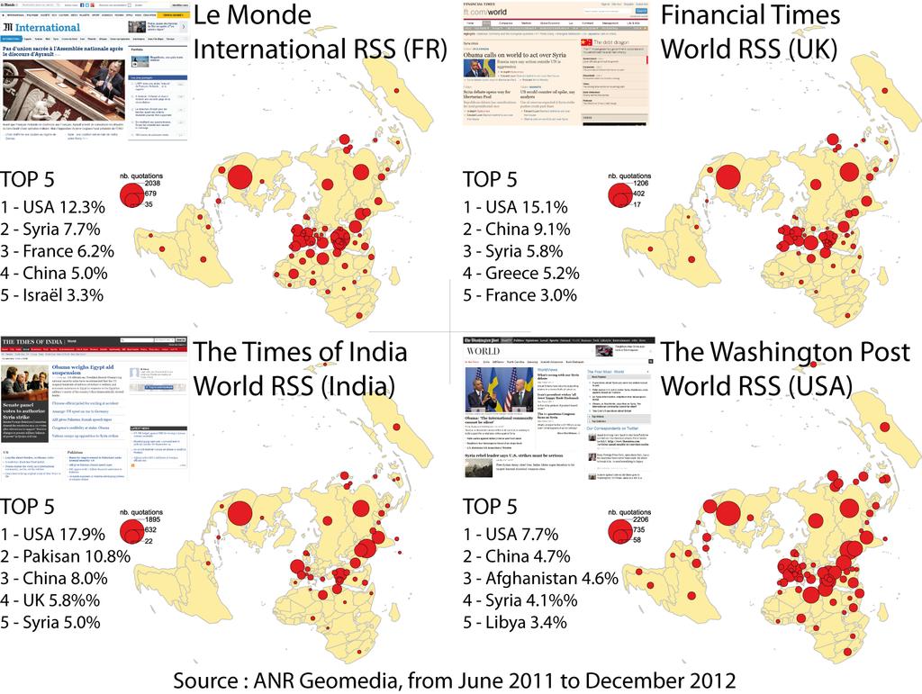
23 Le Monde, 2012 Israel / Palestine. Syrian Crisis
24 Financial Times, 2012 Syrian Crisis Chimerica Region Euro crisis Israel/ Palestin e. «L État : théories et méthodes dans une perspective pluridisciplinaire» UFR GHSS Journée scientifique 23 Mai 2013
25 Washington Post, 2012 Euro Crisis Syrian Crisis Israel / Palestin e. Chimerica Region «L État : théories et méthodes dans une perspective pluridisciplinaire» UFR GHSS Journée scientifique 23 Mai 2013

26 Times of India, 2012 Syrian Crisi Global American Region Israel/ Palestine. «L État : théories et méthodes dans une perspective pluridisciplinaire» UFR GHSS Journée scientifique 23 Mai 2013
27 4. Conclusion Spatial analysis and textual analysis : proposals for a dialogue. 21 February 2017

28 In many cases, sophisticated methods of spatial analysis are applied to data where the quality of identification of places is very poor From BoW to NLP
29 methods Spatial analysis of of text named-entity mining can be applied to places without taking into account the possibility Text Analysis on the Documents of the Barbary Wars
CURRICULUM COURSE OUTLINE
 CURRICULUM COURSE OUTLINE Course Name(s): World Area Studies Grade(s): 9-11 Department: Social Studies Course Length: 1 Semester Pre-requisite: None Textbook/Key Resource: No Primary Textbook Course Description:
Proposed AKS for 6 th Grade Social Studies
 Proposed AKS for 6 th Grade Social Studies A. Map and Globe Skills 1. use cardinal directions 2. use intermediate directions 3. use a letter/number grid system to determine location 4. compare and contrast
Map Of Eastern Hemisphere Labeled
 Map Of Eastern Hemisphere Labeled When somebody should go to the books stores, search instigation by shop, shelf by shelf, it is in reality problematic. This is why we give the book compilations in this
Central Valley School District Social Studies Curriculum Map Grade 7. August - September
 August - September Geographical/Historical Skills Identify and analyze timelines. Construct and use cause and effect charts. Differentiate between fact and opinion. Use of word webs, flip charts, outlines
Texas Essential Knowledge and Skills (TEKS) Science Grade: 6 - Adopted: 2010
 Science Grade: 6 - Adopted: 2010") Main Criteria: Texas Essential Knowledge and Skills (TEKS) Secondary Criteria: Subjects: Science, Social Studies Grade: 6 Correlation Options: Show Correlated Texas Essential Knowledge and Skills (TEKS)
Main Criteria: Texas Essential Knowledge and Skills (TEKS) Secondary Criteria: Subjects: Science, Social Studies Grade: 6 Correlation Options: Show Correlated Texas Essential Knowledge and Skills (TEKS)
Grade 6 Social Studies
 Unit Title: Africa : Movement Location Place Human Region : Subject/Course: 6 th Grade Social Studies Essential Questions: peoples, cultures and ideas of the world? How is a location identified using map
Population Density and Growth. Distribution of people on Earth
 Population Density and Growth Distribution of people on Earth Population Density! Terminology!! Population density is a measure of how compact or concentrated a population is. It takes area of land into
UN-GGIM: An Overview Stefan Schweinfest, Director (UNSD) Bangkok, 27 March 2015
 Bangkok, 27 March 2015") UN-GGIM: An Overview Stefan Schweinfest, Director (UNSD) Bangkok, 27 March 2015 ggim.un.org UN-GGIM: A global initiative Formal inter-governmental UN Committee of Experts to: Discuss, enhance and coordinate
UN-GGIM: An Overview Stefan Schweinfest, Director (UNSD) Bangkok, 27 March 2015 ggim.un.org UN-GGIM: A global initiative Formal inter-governmental UN Committee of Experts to: Discuss, enhance and coordinate
Map Skills Test. 1. What do we call a person who makes maps? a. mapographer b. cartographer c. geologist d. archaeologist
 Map Skills Test 1. What do we call a person who makes maps? a. mapographer b. cartographer c. geologist d. archaeologist 2. What is the name of the 0 latitude line? a. Equator b. Arctic Circle c. First
Big Data at BBVA Research using BigQuery
 Big Data at BBVA Research using BigQuery Tomasa Rodrigo June 2017 Google Cloud Next Click here to modify the style of the master title Summary 01 What is GDELT and how BigQuery helps us to exploit it 02
21st Century Global Learning
 21st Century Global Learning A focus for 7th grade is on the ever-increasing global interactions in society. This focus includes a study of various societies and regions from every continent. We have already
GACE Middle Grades Social Science Assessment Test at a Glance
 GACE Middle Grades Social Science Assessment Test at a Glance Updated June 2017 See the GACE Middle Grades Social Science Assessment Study Companion for practice questions and preparation resources. Assessment
GEOGRAPHY (GE) Courses of Instruction
 Courses of Instruction") GEOGRAPHY (GE) GE 102. (3) World Regional Geography. The geographic method of inquiry is used to examine, describe, explain, and analyze the human and physical environments of the major regions of the
GEOGRAPHY (GE) GE 102. (3) World Regional Geography. The geographic method of inquiry is used to examine, describe, explain, and analyze the human and physical environments of the major regions of the
LEARNING OUTCOMES SST (G1-G12)
") LEARNING OUTCOMES SST (G1-G12) Grade 1 Learning Outcomes Students will be expected to: - demonstrate an understanding of the importance of interactions between people - demonstrate an understanding of
LEARNING OUTCOMES SST (G1-G12) Grade 1 Learning Outcomes Students will be expected to: - demonstrate an understanding of the importance of interactions between people - demonstrate an understanding of
ia PU BLi s g C o M Pa K T Wa i n CD-1576
 M h M y CD-1576 o M Pa g C n ar ia PU BLi s in K T Wa i n ed National Geography Standards National Geography Standards Teachers leading discussions while completing units and activities is a prerequisite
Peoples, Places and Cultures in Africa, Asia and the Southwest Pacific
 GRADE 7 Peoples, Places and Cultures in Africa, Asia and the Southwest Pacific Course 0470-07 Students in seventh grade explore the history, geography, government, economic systems, current issues, and
Big Data at BBVA Research DEIA Encuentros Digitales. Bilbao
 Tracking geopolitical & social events with Big Data at BBVA Research DEIA Encuentros Digitales. Bilbao Tomasa Rodrigo Cross- Country emerging markets unit September 2015 What is Big Data? Velocity Volume
Developing a global, peoplebased definition of cities and settlements
 Developing a global, peoplebased definition of cities and settlements By Lewis Dijkstra, Lewis.Dijkstra@ec.europa.eu Head of the Economic Analysis Sector DG for Regional and Urban Policy, Regional & Urban
Chapter 9: Looking Beyond Poverty: The Development Continuum
 Chapter 9: Looking Beyond Poverty: The Development Continuum Using measures such as Gross Domestic Product (GDP), Gross National Income (GNI), and more recently the Human Development Index (HDI), various
Social Studies Framework K-12 ( ) 1
 1") RIVERVIEW SCHOOL DISTRICT NO. 407 STRAND CIVICS (GOVERNMENT) ECONOMICS HISTORY GEOGRAPHY Grade K Me & My Community Working together Purpose of rules Being a community contributor Compare/contrast needs
RIVERVIEW SCHOOL DISTRICT NO. 407 STRAND CIVICS (GOVERNMENT) ECONOMICS HISTORY GEOGRAPHY Grade K Me & My Community Working together Purpose of rules Being a community contributor Compare/contrast needs
Macroscopic Analysis of Large-scale Systems
 MPI MIS WV Seminar Leipzig, 12 th November 2013 Macroscopic Analysis of Large-scale Systems Robin Lamarche-Perrin Reviewers: Bernard Moulin and Éric Fleury Examiners: Salima Hassas and Brigitte Plateau
Complete the following: a. Lines of latitude are parallel to the equator. Name:
 Name: Date: Social Studies Introduction: Basic Geography Period: Latitude Latitude is defined as a measurement of distance in degrees north and south of the equator. The word latitude is derived from the
Discovering the World of Geography
 Discovering the World of Geography Grades 7 8 By MYRL SHIREMAN COPYRIGHT 2003 Mark Twain Media, Inc. ISBN 10-digit: 1-58037-230-9 13-digit: 978-1-58037-230-5 Printing No. CD-1576 Mark Twain Media, Inc.,
Unit of Study: Physical Geography & Settlement Patterns; Culture & Civilizations; and The Spread of Ideas
 6 th Grade Social Studies 1 st Nine Weeks TEKS Unit of Study: Physical Geography & Settlement Patterns; Culture & Civilizations; and The Spread of Ideas 6.1) History. The student understands that historical
Critical Thinking. about GEOGRAPHY. The Middle East. Jayne Freeman
 Critical Thinking about GEOGRAPHY The Middle East Jayne Freeman WALCH EDUCATION The classroom teacher may reproduce materials in this book for classroom use only. The reproduction of any part for an entire
AP Human Geography Summer Homework 2016 JW Mitchell High School Mrs. Daniel
 AP Human Geography Summer Homework 2016 JW Mitchell High School Mrs. Daniel hdaniel@pasco.k12.fl.us Welcome to A.P. Human Geography. I am excited that you decided to take this journey to learn more about
September 14, 2013 Objective: How does geography impact history? What important features exist that have shaped societies?
 Lowenhaupt 1 September 14, 2013 Objective: How does geography impact history? What important features exist that have shaped societies? Warm-Up: In your binder, answer the following question: Imagine you
The study of Geography and the use of geographic tools help us view the world in new ways.
 S How does Geography help us understand our world? What factors shape the Earth s different environments? 7.1.9 7.2.9 BIG IDEAS COMPETENCIES Text pages or The study of Geography and the use of geographic
Instructor: Shashi Krishna Fall Everything is somewhere - Finding a Focus for Spatial Study is Geography
 Geography 1303.001 002 Instructor: Shashi Krishna Fall 2011 Everything is somewhere - Finding a Focus for Spatial Study is Geography Geography is the science of place. Its vision is grand, its views panoramic.
relationships between physical environments an society
 Lesson Plans Geography Grade 9 Mrs. Newgard Monday, December 7 o Objective: Find out what has affected the modern development of the Arabian Peninsula. Go over Arabian Peninsula map together Notes 18.4
Social Studies Curriculum Sixth Grade
 Social Studies Curriculum Sixth Grade A. History Students will examine the key historic movements, events, and figures that contributed to the development of modern Europe and American nations from early
Boundaries and Borders
 Political Geography Origins: Antecedent Boundaries and Borders Existed in prehistoric times Usually align with physical boundaries Pyrenees between France/Spain Cultural linguistic borders between Germanic
Asia. JigsawGeo. Free Printable Maps for Geography Education. Try our geography games for the ipod Touch or iphone.
 Free Printable Maps for Geography Education Map with region names shown Map without names, for coloring or quizzes Map with coordinate system, for location practice Answer key for coordinate system quiz
DISTRIBUTION COURSES THAT CAN BE USED TOWARD THE B.A. IN GLOBAL STUDIES ELECTIVES IN GLOBAL ECONOMICS, POLITICS AND CULTURE. Distribution Courses
 DISTRIBUTION COURSES THAT CAN BE USED TOWARD THE B.A. IN GLOBAL STUDIES ELECTIVES IN GLOBAL ECONOMICS, POLITICS AND CULTURE Humanities Division (LT, AA) Distribution Courses Literature (LT) (Check Regional
*BOLD text indicates Prioritized Standard May GSE Seventh Grade Social Studies Curriculum
 *BOLD text indicates Prioritized Standard 1 GSE Seventh Grade Social Studies Curriculum Standards: SS7G5; G6; G7; G8 (G8c) 4 Weeks Standards: SS7H2 (H2c) 3 Weeks Standards: SS7CG3 Standards: SS7E4; E5;
GEOGRAPHY YEAR 11 ATAR 2019 COURSE OUTLINE
 GEOGRAPHY YEAR 11 ATAR 2019 COURSE OUTLINE Geography ATAR Year 11 Semester 1 Unit 1 Natural and ecological hazards 1 3 Geographical skills Mapping skills identify and interpret a variety of topographic
... Asia. Based on Bloom s Taxonomy. Human & Movement. Location Place. Regions. Environment. Interactions
 ... Asia Location Place Human & Environment Interactions Movement Regions LEVEL 1 Knowledge Match Show or Label List Information Recall Details (5Ws + H) Find Information LEVEL 2 Comprehension LEVEL 3
Prentice Hall. World Explorer: People, Places, Cultures Grade 7. Oklahoma Priority Academic Student Skills (PASS) for Grade 7 World Geography
 for Grade 7 World Geography") Prentice Hall World Explorer: People, Places, Cultures 2007 Grade 7 C O R R E L A T E D T O for Grade 7 1. Locate, gather, analyze, and apply information from primary and secondary sources. WORLD GEOGRAPHY
Prentice Hall World Explorer: People, Places, Cultures 2007 Grade 7 C O R R E L A T E D T O for Grade 7 1. Locate, gather, analyze, and apply information from primary and secondary sources. WORLD GEOGRAPHY
An Investigation on Employment Situation of Sociology Graduates and Effective Foctors Influencing on It
 165 An Investigation on Employment Situation of Sociology Graduates and Effective Foctors Influencing on It S. Ahmadi 1 One of the most important social problems in Iran is widespread unemployment of university
Stillwater Area Schools Curriculum Guide for Elementary Social Studies
 Stillwater Area Schools Curriculum Guide for Elementary Social Studies Grade Four Draft March 21, 2006 Minnesota and the St. Croix Valley I. Historical Skills A. The student will acquire skills of chronological
Northwestern Consolidated Schools of Shelby County. Curriculum. World Studies (Eastern Hemisphere) Prepared by. Rich Ballard
 Prepared by. Rich Ballard") Northwestern Consolidated Schools of Shelby County Curriculum World Studies (Eastern Hemisphere) 7th Grade Prepared by Rich Ballard 2012-2013 1 Triton Central Middle School Vision Statement We are committed
Northwestern Consolidated Schools of Shelby County Curriculum World Studies (Eastern Hemisphere) 7th Grade Prepared by Rich Ballard 2012-2013 1 Triton Central Middle School Vision Statement We are committed
Which diversity in the hierarchical organisation of urban systems in Europe?
 Which diversity in the hierarchical organisation of urban systems in Europe? Denise Pumain Université Paris I, UMR Géographie-cités Céline Rozenblat Université de Lausanne 1 A geographical ontology of
Amarillo ISD Grade 6 Standards
 Amarillo Independent School District follows the Texas Essential Knowledge and Skills (TEKS). All of AISD curriculum and documents and resources are aligned to the TEKS. The State of Texas State Board
East View Cartographic
 New Developments in Access to Russian Military Mapping 1 + affiliate of East View Publications (est. 1989) + EVP is by far the largest supplier of vernacular-language open-source information from Russia/CIS
Bengt Kjellson Chair of the Executive Committee UN-GGIM: Europe. 2 nd Joint UN-GGIM: Europe ESS Meeting 11 th March 2016, Luxembourg
 Bengt Kjellson Chair of the Executive Committee UN-GGIM: Europe 2 nd Joint UN-GGIM: Europe ESS Meeting 11 th March 2016, Luxembourg A global geospatial mandate At its 47th plenary in July 2011, ECOSOC,
By Geri Flanary To accompany AP Human Geography: A Study Guide 3 rd edition By Ethel Wood
 Session 1 By Geri Flanary To accompany AP Human Geography: A Study Guide 3 rd edition By Ethel Wood WHAT IS DEMOGRAPHY? It is the scientific or statistical study of population. It comes from the Greek
Alleghany County Schools Curriculum Guide GRADE/COURSE: World Geography
 GRADE/COURSE: World 2013-14 GRADING PERIOD: 1 st Six Weeks Time Frame Unit/SOLs SOL # Strand Resource Assessment 8 days* The student will use maps, globes, satellite images, photographs, or diagrams to
Ohio s State Tests ANSWER KEY & SCORING GUIDELINES GRADE 6 SOCIAL STUDIES PART 1
 Ohio s State Tests ANSWER KEY & SCORING GUIDELINES GRADE 6 SOCIAL STUDIES PART 1 Table of Contents Questions 1 4: Content Summary and Answer Key...1 Question 1: Question and Scoring Guidelines...3 Question
Writing Methodology of a Geopolitical Analysis. [Structure, Concepts and Terms]
![Writing Methodology of a Geopolitical Analysis. [Structure, Concepts and Terms]](/thumbs/94/119410065.jpg "Writing Methodology of a Geopolitical Analysis. [Structure, Concepts and Terms]") Writing Methodology of a Geopolitical Analysis. [Structure, Concepts and Terms] International Crisis Management Conference ATHENA 2008 Athens 2-5 july 2008 Presentation of Dr. Ioannis Th. Mazis, Professor
Writing Methodology of a Geopolitical Analysis. [Structure, Concepts and Terms] International Crisis Management Conference ATHENA 2008 Athens 2-5 july 2008 Presentation of Dr. Ioannis Th. Mazis, Professor
A Correlation of. Eastern Hemisphere. Ohio s Learning Standards Social Studies: K-12 Grade 6
 A Correlation of Eastern Hemisphere To Grade 6 to,, Grade 6 Introduction This document demonstrates how, Eastern Hemisphere, Ohio Edition, meets : K-12 Social Studies for Grade 6. Correlation page references
relationships between physical environments an society o Objective: Connect issues going on in East Africa with the United States Bell Ringer
 Monday, February 1 o Objective: Show the knowledge of East Africa s physical land and culture 21.2 Quiz Eastern Africa country and capital quiz Research current event articles in East Africa Watch CNN
Global Studies A and B Mr. Lord
 1. ARRIVE ON TIME. Global Studies A and B Mr. Lord michael.lord@orecity.k12.or.us Global Studies A and B Classroom Rules and Grading Expectations 2. BE PREPARED BOTH MENTALLY AND PHYSICALLY FOR CLASS.
Course Outcome Summary
 Course Information: Description: Instruction Level: Total Credits: Prerequisites: Textbooks: Human Geography The starting point of this class will include basic building block skills, such as how to read
Global Data Catalog initiative Christophe Charpentier ArcGIS Content Product Manager
 Global Data Catalog initiative Christophe Charpentier ArcGIS Content Product Manager ccharpentier@esri.com We are in a global economy Global Economy Business and Operations are now global Strategic need
DEPARTMENT OF GLOBAL STUDIES AND GEOGRAPHY COURSES OFFERED - SPRING 17 SEMESTER GEOGRAPHY
 DEPARTMENT OF GLOBAL STUDIES AND GEOGRAPHY COURSES OFFERED - SPRING 17 SEMESTER What Should You Take First? GEOGRAPHY Besides our Senior Seminars (and Geog 160), our classes can be taken at any time, whether
Global maritime connectivity: a long-term perspective
 Global maritime connectivity: a long-term perspective César Ducruet To cite this version: César Ducruet. Global maritime connectivity: a long-term perspective. Port Technology International, Maritime Information
Social Studies Continuum
 Historical Skills chronological thinking understand that we can learn about the past from different sorts of evidence begin to use historical resources apply research skills by investigating a topic in
International Studies Program Electives
 International Studies Program Electives Elective courses may be selected from an array of academic areas, including international studies, anthropology, applied communications studies, art and design,
HPISD CURRICULUM (SOCIAL STUDIES, GRADE 6)
") HPISD CURRICULUM (SOCIAL STUDIES, GRADE 6) EST. NUMBER OF DAYS: 6A 10 DAYS, 6B 15 DAYS UNIT NAME Unit Overview Generalizations/Enduring Understandings TOPIC 6A: NORTH AFRICA TOPIC 6B: SOUTHWEST ASIA A-B:
HPISD CURRICULUM (SOCIAL STUDIES, GRADE 6) EST. NUMBER OF DAYS: 6A 10 DAYS, 6B 15 DAYS UNIT NAME Unit Overview Generalizations/Enduring Understandings TOPIC 6A: NORTH AFRICA TOPIC 6B: SOUTHWEST ASIA A-B:
POTENTIAL COURSES FOR CEP STUDENTS AND THEIR AREAS OF INTERST
 POTENTIAL COURSES FOR CEP STUDENTS AND THEIR AREAS OF INTERST C ENV 110 Food & Environment CHSTU 320 Food Sovereignty in Mexico and the United States ANTH 361 Anthropology of Food ANTH 488 Agroecology
AP Human Geography Summer Assignment
 P Human Geography Summer ssignment P Human Geography is not a traditional geography class. Instead of learning about the locations of physical and political features, this course focuses on the interactions
GRADE 8 LEAP SOCIAL STUDIES ASSESSMENT STRUCTURE. Grade 8 Social Studies Assessment Structure
 Grade 8 Social Studies Assessment Structure 1 In 2013-2014, the grade 8 LEAP test continues to assess Louisiana s social studies benchmarks. The design of the multiple-choice sessions of the test remains
DEPARTMENT OF GLOBAL STUDIES AND GEOGRAPHY COURSES OFFERED - FALL 18 SEMESTER GEOGRAPHY
 DEPARTMENT OF GLOBAL STUDIES AND GEOGRAPHY What Should You Take First? COURSES OFFERED - FALL 18 SEMESTER GEOGRAPHY Besides our Senior Seminars (and Geog 160), our classes can be taken at any time, whether
Egypt-NOAA Cooperation: Advancing our Environmental Science, Technology, and Education
 Egypt-NOAA Cooperation: Advancing our Environmental Science, Technology, and Education T. G. Onsager NOAA Space Weather Prediction Center and NWS International Activities Office (one-year detail) Terry.Onsager@noaa.gov
Multimedia on Nuclear Reactor Physics In order to improve education and training quality, a Multimedia on Nuclear Reactor Physics has been developed.
 MULTIMEDIA ON NUCLEAR REACTOR PHYSICS Prof. PhD. Javier Dies, Doctor Engineer Professor Chair in Nuclear Engineering g Upc- Barcelona-Tech, Spain Nuclear Engineering Research Group (NERG), Departament
Name three countries in Europe.
 Name three countries in Europe. I will be able to identify the 5 themes of geography for Europe and locate the countries and capitals of Europe and the major physical features. People: Past: Through the
International Student Enrollment Fall 2018 By CIP Code, Country of Citizenship, and Education Level Harpur College of Arts and Sciences
 International Student Enrollment Fall 2018 By CIP Code, Country of Citizenship, and Education Level Harpur College of Arts and Sciences CIP Code Description Citizenship Graduate Undergrad Total 00.0000
1 st Six Weeks # of Days. Unit # and Title Unit 1 Geography Overview
 1 st Six Weeks # of Days Unit # and Title Unit 1 Geography Overview Orange Grove ISD Instructional Planning Information and Process Standards The Process Standards Must Be Included in Each Unit # of Class
World Geography to ALL Students book (teacher book).
.") Sample Pages are from the What I Need to Know to Successfully Teach World Geography to ALL Students book (teacher book). This book contains the content in the student book, the reformatted Standards for
Sample Pages are from the What I Need to Know to Successfully Teach World Geography to ALL Students book (teacher book). This book contains the content in the student book, the reformatted Standards for
NAEP released item, Grade 8
 Find the political map of Africa and the land use map. Which city is a major center of manufacturing and trade? A) Kinshasa, Congo B) Tunis, Tunisia C) Lusaka, Zambia D) Luanda, Angola Key Find the political
Summer 2017 Global Studies Recommended Course List
 Summer 2017 Global Studies Recommended Course List Students must work with advisors to determine whether courses on this list will work with their Major Plan of Study. Courses should be considered as options
TOPIC 8: POPULATION DISTRIBUTION AND URBANIZATION
 TOPIC 8: POPULATION DISTRIBUTION AND URBANIZATION Concept of population distribution Factors affecting population distribution and density Urbanization: Concept and issues associated Introduction WORLD
D ESK A TLAS.COM MAPS N YSTROM NYSTROM. Name
 MAPS A TLAS.COM Exploring NystromDeskAtlas.com The resources in NystromDeskAtlas.com will help you learn more about our world. The site s maps, graphs, photos, and links offer a wealth of information about
Final report for the Expert Group on the Integration of Statistical and Geospatial Information, May 2015
 Final report for the Expert Group on the Integration of Statistical and Geospatial Information, May 2015 Global geographic classification and geocoding practices Executive summary This final report was
(Emerging?) topics in resilience research perspectives from a critical urban and regional studies view
 topics in resilience research perspectives from a critical urban and regional studies view") (Emerging?) topics in resilience research perspectives from a critical urban and regional studies view Thilo Lang Head of Department Regional Geography of Europe Leibniz Institute for Regional Geography
(Emerging?) topics in resilience research perspectives from a critical urban and regional studies view Thilo Lang Head of Department Regional Geography of Europe Leibniz Institute for Regional Geography
Word Cards. 2 map. 1 geographic representation. a description or portrayal of the Earth or parts of the Earth. a visual representation of an area
 Name: Date: Hour: Word Cards 1 geographic representation a description or portrayal of the Earth or parts of the Earth Example: A map is a representation of an actual location or place. 2 map a visual
Knowledge and understanding Geographical skills. Sample pages. features people processes world places events environments characteristics
 1.1 What is geography? Knowledge and understanding Geographical skills verbal linguistic visual spatial 1 Give two reasons why it is important to study geography. 2 Use words from the box below to complete
YORK UNIVERSITY - UNIVERSITÉ YORK
 Faculty of Liberal Arts and Professional Studies Administrative Studies 1,538 1,323 336 309 3,506 0 0 1 0 1 African Studies 0 0 0 0 0 3 6 2 3 14 Anthropology 49 90 9 30 178 0 0 0 0 0 Applied Mathematics
Seymour Centre 2017 Education Program 2071 CURRICULUM LINKS
 Suitable for: Stage 5 Stage 6 HSC Subject Links: Seymour Centre 2017 Education Program 2071 CURRICULUM LINKS Science Stage Content Objective Outcomes Stage 5 Earth and Space ES3: People use scientific
SDI Developments in the World s Currently Existing Mega Cities
 SDI Developments in the World s Currently Existing Mega Cities Silke Boos and Hartmut Müller FIG Working Week 2009 Surveyors Key Role in Accelerated Development, Eilat, Israel, 3-8 May 2009 TS 1B SDI in
SKILLS (MA State Standards/Learning Outcomes)
") BRISCOE MIDDLE SCHOOL, BEVERLY, MA SOCIAL STUDIES CURRICULUM MAP & PACING GUIDE REVISED: JUNE 2012 GRADE 7 AUTHORS & GRADE-7 TEACHERS: Mr. Brian Bayer-Larson/Ms. Joy Benosky/Mr. Adam Olbash SEPTEMBER OCTOBER
BRISCOE MIDDLE SCHOOL, BEVERLY, MA SOCIAL STUDIES CURRICULUM MAP & PACING GUIDE REVISED: JUNE 2012 GRADE 7 AUTHORS & GRADE-7 TEACHERS: Mr. Brian Bayer-Larson/Ms. Joy Benosky/Mr. Adam Olbash SEPTEMBER OCTOBER
6 th Grade: Regions and People of the World ESC Suggested Pacing Guide
 6 th Grade: Regions and People of the World ESC Suggested Pacing Guide 2008-09 The sixth grade year focuses on the study of world regions. The concentration is geographic rather than historic. Students
Complementary Studies Elective Courses
 Complementary Studies Elective Courses Effective July 1, 2016 The Complementary Studies component of the Bachelor of Engineering Degree programs at Lakehead University consists of three parts. Students
Social Studies Grade 2 - Building a Society
 Social Studies Grade 2 - Building a Society Description The second grade curriculum provides students with a broad view of the political units around them, specifically their town, state, and country.
London and Paris In the networks of multinational firms
 Canterbury - 2011 London and Paris In the networks of multinational firms Prof. Céline Rozenblat Institute of Geography - University of Lausanne Switzerland ESPON FOCI project 2008-2011 Future orientation
Wayne E. Sirmon GEO 301 World Regional Geography
 Wayne E. Sirmon GEO 301 Geography 301 Geography 301 MAP: A graphic representation of a portion of the earth s surface dawn to scale, as seen from above. Types of Maps Climate maps give general information
TYPES OF GOVERNMENTS
 While the terms country, state, and nation are often used interchangeably, there is a difference. A State (note the capital "S") is a self-governing political entity. The term State can be used interchangeably
Unit 1 Welcome to the World
 Unit Welcome to the World There are five fields of learning in social studies. We learn about the world and its people by studying geography, history, economics, government, and culture. A Mongolian yurt,
5 th Grade Social Studies Goals for the First Trimester Miss Gaull
 5 th Grade Social Studies Goals for the First Trimester Overview: American People, American Land The American People Government by the People Free Enterprise Lands and Regions Resources and the Environment
1. Match the words in the first column to the meaning in the second column. [5]
![1. Match the words in the first column to the meaning in the second column. [5]](/thumbs/96/126839765.jpg "1. Match the words in the first column to the meaning in the second column. [5]") Exercise 1: [40 POINTS] 1. Match the words in the first column to the meaning in the second column. [5] Equator Around earth between the Equator and the Poles. Greenwich meridian Half of earth. Longitude
Exercise 1: [40 POINTS] 1. Match the words in the first column to the meaning in the second column. [5] Equator Around earth between the Equator and the Poles. Greenwich meridian Half of earth. Longitude
Enrollment at a Glance Fall 2015
 1. Number of Students Enrolled at Tenth Day of Fall Term 2011 2012 2013 2014 2015 3,705 ( 100.0% ) 3,626 ( 100.0% ) 3,706 ( 100.0% ) 3,746 ( 100.0% ) 3,891 ( 100.0% ) New 1 1,051 ( 28.4% ) 1,063 ( 29.3%
Seasonal Forecast for the area of the east Mediterranean, Products and Perspectives
 Seasonal Forecast for the area of the east Mediterranean, Products and Perspectives Dr Kleanthis Nicolaides Senior Meteorological Officer Department of Meteorology The need for weather forecasts from where
INTERNATIONAL S T U D E N T E N R O L L M E N T
 The University of California at Berkeley INTERNATIONAL S T U D E N T E N R O L L M E N T Fall 2008 Prepared by: Berkeley International Office 2299 Piedmont Avenue Berkeley, CA 94720-2321 510.642.2818 http://internationaloffice.berkeley.edu/
Norwich City Schools Social Studies 6
 Social Studies 6 Topic: Maps and Globes and Graphs and Time Transferable Concepts: change 3: Geography Geography Geographers use maps, globes, and graphs to study the Earth and everything on it. Types
Cultural Geography. Chapter 1
 Cultural Geography Chapter 1 What is Geography? The study of the interaction of all physical and human phenomenon at individual places, and how interactions among places form patterns and organize space.
Lesson Plans. Geography. Grade 9. Mrs. Newgard. Monday, February 22
 Monday, February 22 o Objective: Compare and Contrast two African regions South African Map Quiz South Africa Current Events Lesson Plans Geography Grade 9 Mrs. Newgard Tuesday, February 23 relationships
Students will able to: Define Geography Explain the 5 Themes Analyze the 5 Themes with an example
 What is Geography? Students will able to: Define Geography Explain the 5 Themes Analyze the 5 Themes with an example What is Geography Geography is about spatial thinking The questions we want to ask What
Unit 1: Geography and Social Studies Skills
 Unit 1: Geography and Social Studies Skills Standard(s) of Learning: WHI.1 The student will improve skills in historical research and geographical analysis by a) Identifying, analyzing, and interpreting
Study scope. 13 MENA countries: Morocco, Algeria,
 Rich Place, Poor Place How MENA will overcome spatial disparities Publication due April 2010 Study scope 13 MENA countries: Morocco, Algeria, Tunisia, i Libya, Egypt, West Bank and Gaza, Jordan, Syria,
ESPON evidence on European cities and metropolitan areas
 BEST METROPOLISES Final Conference 18 April 2013, Warsaw ESPON evidence on European cities and metropolitan areas Michaela Gensheimer Structure of Intervention Content Part I: What is the ESPON 2013 Programme?