Our Endangered Coastal Ecosystems:
|
|
|
- Alexandrina Felicia Floyd
- 6 years ago
- Views:
Transcription

1 Our Endangered Coastal Ecosystems: an Eco climatic and Risk Analysis using GIS and Remote Sensing SANGA-NGOIE Kazadi and Shoko KOBAYASHI Climate and Ecosystems Dynamics Health, Environment and Life Science Institute Ritsumeikan Asia Pacific University e mail: sangank@apu.ac.jp
2 Contents 1. Introduction: Definition and Role of Coastal Ecosystems 2. Changes, impacts and risks in the Asia Pacific Area 3. Our role within this Research Group 4. Some cases studies (Mie, Japan) 5. Concluding remarks
3 Contents 1. Introduction: Definition and Role of Coastal Ecosystems 2. Changes, impacts and risks in the Asia Pacific Area 3. Our role within this Research Group 4. Some cases studies (Mie, Japan) 5. Concluding remarks

4 The Coastal Zone and Coastal Ecosystems Modest surface of the globe: 26 millions km2 Sustained Land Ocean Atmosphere interactions Physical, biological and biogeochemical interactions Important role in the global flow of matter and energy

5 Coastal Ecosystems Estuaries, wetlands, intertidal flats, Mangrove and swamp forests Lagoons, salt ponds, rocks and sand beaches Seagrass, coral reefs, continental shelf

6 Sustainable land ocean atmospheric flow of matter and energy 1. Biochemical cycle of all land driven material entering the sea 2. Most of geochemical & biological activities in the biosphere 15% of oceanic primary production 80% of organic matter burial 90% of sedimentary mineralization 3. 40% of World ecosystem service value and natural capital 4. Human population (40% within 100 km) and human activities

7 Ever increasing human population and man made transformations (Cape Town, South Africa) 40% of world population living within 100 km from the ocean coasts Deep changes to the shape, contents and functions of the ecosystem Scenic shoreline cities, ports, resort beaches, land reclamation, etc
8 Major Coastal Ecosystems in the World Millennium Ecosystem Assessment (2005).
9 Contents 1. Introduction: Definition and Role of Coastal Ecosystems 2. Changes, impacts and risks in the Asia Pacific Area Sea level rise due to Global Warming Floods due to typhoons, storms and tsunamis Land claim, urbanization and coastal development Upland activities involving land cover change A combination of any of these elements 3. Our role within this Research Group 4. Some cases studies (Mie, Japan) 5. Concluding remarks
10 (IPCC 2007, WG II)
11 (IPCC 2007, WG I)

12 (IPCC 2007, WG I)

13 Vulnerability of Coastal Deltas to Sea level Rise (IPCC 2007, WG II)


14 Indian Ocean Tsunami and its aftermath Dec 2004: Tsunami devastated the region of Banda Aceh


15 Climate Change and Extreme Weathers Frequent Typhoons, Severe Storms, Floods and Water Disasters


16 Impact of flooding in Phnom Penh, Cambodia These images show the extent of flooding and extensive ditches and canals used for irrigation 2000: Taken during the period of flooding 2001: Taken after the flood waters had receded


17 Water Disaster due to Typhoons and Heavy Rains Floods in the Nagoya Area, September 2000

18 Replacement of mangroves by aquaculture in Thon Buri, Thailand : Area is caught in the battle between needs of people versus the welfare of the coastal areas 2002: Shows extensive aquaculture ponds (blue patches inland)


19 Mangrove Forests Destruction for Shrimp Ponds (Samut Songkram, Thailand) Abandoned Shrimp Ponds now used for salt production
20


21 Land reclamation changes along Isahaya Bay, Japan 1993: Turning tidal lands into farmlands 2001: The straight line of the sea wall is visible 2003: The area has been fully reclaimed from the sea

22 Dramatic changes in Huang He Delta, China Images show the mouth of the Yellow River and the emergence of a huge parrot headed peninsula : Huang He s yellow color is the result of huge loads of sediments


23 Changes in Huang He Delta, China From 1989 to 1995 the Yellow River delta area grew From 1995 to 2000 the Yellow River delta area shrank Credit: NASA Earth Observatory


24 Changes due to construction of Three Gorges Dam, China 1987: Nature of the river and surrounding landscape before the dam 2004: The enormous dam is clearly visible


25 Land Cover Changes Upland Natural Climatic change and extreme weathers Land development by human activities Heat Waves and Forests Fires, Deforestation Desertification, Drought and Famine
26 Contents 1. Introduction: Definition and Role of Coastal Ecosystems 2. Changes, impacts and risks in the Asia Pacific Area 3. Our role within this Research Group GIS (Geographical Information Systems) Remote Sensing Technology and Data Simulation and Prediction scenarios Decision Support Systems: prevention, mitigation, preparedness 4. Some cases studies (Mie, Japan) 5. Concluding remarks
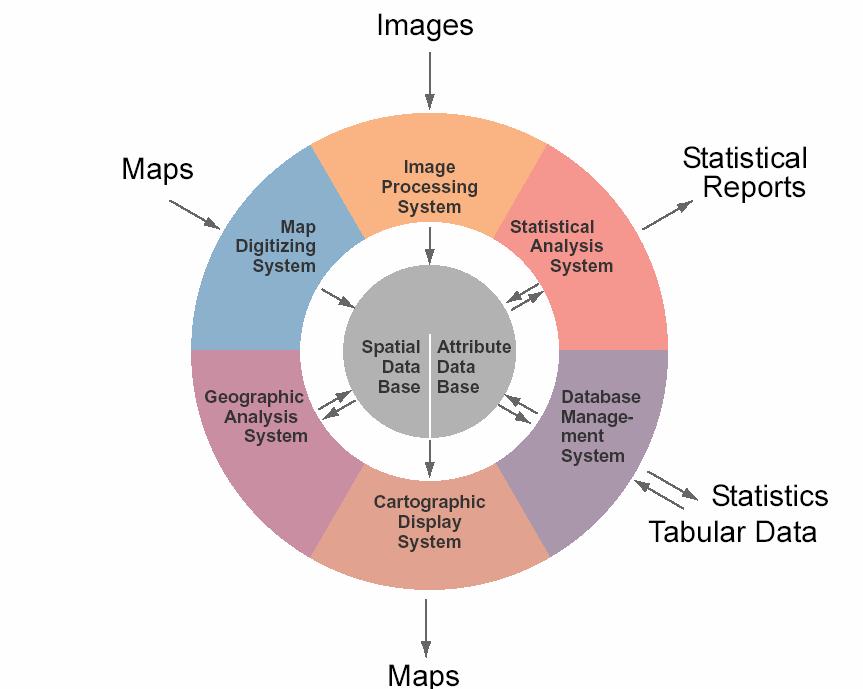
27 Why GIS and Why Remote Sensing? Remote Sensing: allows to grasp the state of, or the change in, the ecosystem over a broad area within a sequence of temporal scenes (qualitatively) GIS (Geographic Information Systems) makes it possible: to query for features or location of specific state or changes to quantitatively measure the state or changes to simulate and predict changes to create quantitative scenarios for sound Decision Making, based on single or multi criteria analysis
28 2 1 GIS
29 What can we do with GIS? Organization ( 組織化 ) Visualization ( 視覚化 ) Spatial Query ( 空間探索 ) Combination ( 結合 ) Analysis ( 解析 ) Prediction ( 予測 ) Decision Support ( 意思決定支援 )
30 Contents 1. Introduction: Definition and Role of Coastal Ecosystems 2. Changes, impacts and risks in the Asia Pacific Area 3. Our role within this Research Group 4. Some cases studies using GIS and RS (Mie, Japan) Impacts of sea level rise in Ise Bay Risks assessment using LU/LC map in Tsu City Tsunami Risk assessment in Kii Nagashima Tsunami Risk assessment and population preparedness/awareness in Nishiki 5. Concluding remarks
31 Global Warming Temperature (T) Sea Surface Level (SSL)


32 Changes due to Sea Level Rise (Yokkaichi Kuwana Area, Mie) 鉄道 国道 20cm 上昇 1m 上昇
")
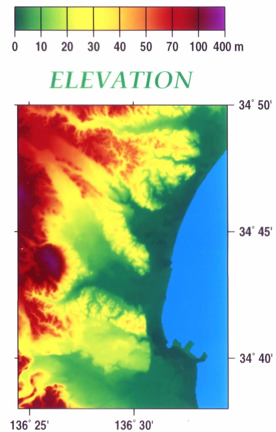
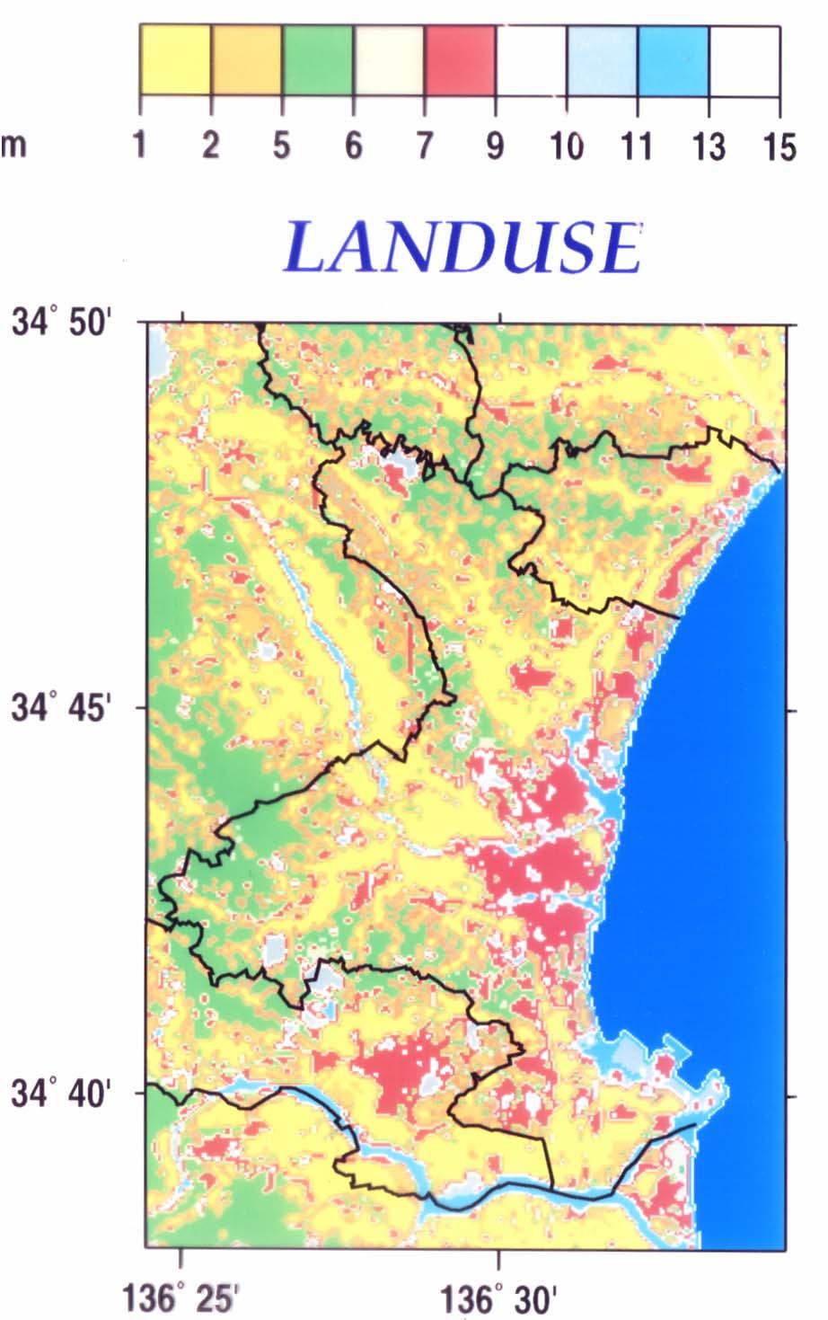
33 Land Use/ Land Cover Classification (Tsu) Fields Coniferous Mixed Others Wastelands Barren Water City Residence Industry Golf Court Grassy Sparse Mixed JR Railways Highway National Prefectural Roads Local Adm. limits TSU area (LANDSAT, 1987)
34
35 Sea level rise Risk Assessment per LU/LC category in Tsu, Mie (between 津市の被害の割合 2010 and 2060) 600 (hectares) ha 年 海水域 Water body 海浜 Beach 河川敷 Estuaries 湖沼 池 Wetlands/Mars その他の用地 h 空地 Miscellaneous 幹線交通用地 Non occupied 建物用地 Rails and Roads 荒地 Built up area 森林 Wasteland 畑 Forests 田 Orchards Rice Fields
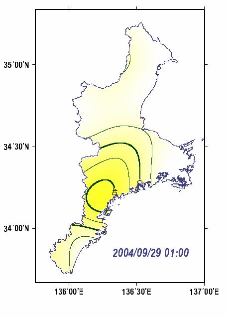
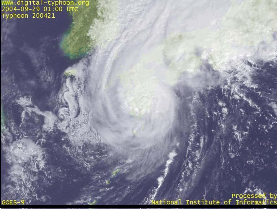
36 (a) (b) 2004/09/29 10:00 JST Figure 1
37 Tokai/Tonankai/Nankai Earthquake Simulation - risk assesssment and preparedness in Mie - Scenario: Magnitude M8.7 earthquake off the Pacific Coast Just after the earthquake, - First wave: about 10 min - Second wave: about 20 min maximum 5m (Kii-Nagashima) maximum 7m (Nishiki) People have about 10 min to leave their homes and run for security to the escape areas.


38 Tsunami disaster simulation Kii Nagashima, Mie 95% of the Town submerged under a 5m wave Awareness Preparedness Mitigation

 Now: population 2,556")
39 Nishiki Village, Mie Devasted by un Tsunami caused by a M7.9 earthquake on (20 km off) (Tsunami: 6m high; 447 houses destroyed; 64 dead) Now: population 2,556 (M:1,211; F:1,345)

40 Location of the 25 Refuge sites in Nishiki No name 津波避難所 標高 避難所構造 避難位置高さ 01 福羅会館 4m 1F 0m 02 錦中学校グランド 6m 屋外 0m 03 錦中学校 5m 3F 8m 04 東町避難所 40m プレハブ 0m 05 谷山会館 10m 1F 0m 06 浅間山避難所 32m 屋外 0m 07 中町避難所 14m プレハブ 0m 08 錦神社 19m 屋外 0m 09 錦漁業協同組合 3m 3F 6m 10 伊勢農協紀勢支店 3m 3F 6m 11 清甫園避難所 20m プレハブ 0m 12 的場防災会館 14m 2F 3m 13 金蔵寺 17m 屋外 0m 14 社会福祉センター 3m 2F 3m 15 老人福祉センター 2m 2F 3m 16 釜土避難所 28m プレハブ 0m 17 浅ヶ谷防災会館 12m 1F 0m 18 ジロハゲ避難所 32m 屋外 0m 19 錦タワー 4m 5F 12m 20 錦小学校 7m 3F 8m 21 錦小学校グランド 6m 屋外 0m 22 錦あおぞら保育園 22m 1F 0m 23 錦みなとホール 28m 1F 0m 24 役場錦支所 32m 3F 8m 25 高岡会館 7m 1F 0m (m)
41 Vulnerability of the Refuge sites - 11 out the 25 sites will be under waters! -Only a few sites are safely above the wave level (m)
42 Preparedness, Awareness and Mitigation Strategy Truly safe: 3 sites Relatively Safe: 11 sites Dangerous: 5 sites Not safe : 6 sites People have to instructed to run for safety to the TRULY SAFE SITES in case of Tsumani!
43 Preparedness, Awareness and Mitigation Strategy % of the population live in the high risk area % of those who did not run for safety live in the high risk area % of those who ran for safety are from the high risk area % of people living in the high risk area did not run for safety - Most of those who run went to wrong and unsafe sites!

44 The most appropriate Site


45 The shortest distance to the safe site Case 1 Case 2 Start Point Objective Start Point Objective
46 Contents 1. Introduction: Definition and Role of Coastal Ecosystems 2. Changes, impacts and risks in the Asia Pacific Area 3. Our role within this Research Group 4. Some cases studies using GIS and RS (Mie, Japan) 5. Concluding remarks

47 Our role: Data integration: spatial observation, numerical (NWP), statistical Decision Support System: risk, mitigation and prevention scenarios for sound Decision Making
48

49 Integrated HAZARD MAP of Major Coastal Ecosystems in the Asia Pacific Area Using GIS & RS

50 The End Thank you very much for your attention! For any contact: e mail: sangank@apu.ac.jp Tel: Fax:
Introduction to Environmental Geology, 5e Case History: Indonesian Tsunami Indonesian Tsunami (2) Introduction Historic Tsunamis
 Introduction Historic Tsunamis") 1 2 3 4 5 6 7 8 9 Introduction to Environmental Geology, 5e Chapter 7 Tsunami Case History: Indonesian Tsunami December 26, 2004, within a few hours, close to 250,000 people were killed With no warning
1 2 3 4 5 6 7 8 9 Introduction to Environmental Geology, 5e Chapter 7 Tsunami Case History: Indonesian Tsunami December 26, 2004, within a few hours, close to 250,000 people were killed With no warning
Introduction to Environmental Geology, 5e
 Lecture Presentation prepared by X. Mara Chen, Salisbury University Introduction to Environmental Geology, 5e Edward A. Keller Chapter 7 Tsunami Case History: Indonesian Tsunami December 26, 2004, within
Introduction to Multi-hazard Risk-based Early Warning System in Japan
 Introduction to Multi-hazard Risk-based Early Warning System in Japan Yasuo SEKITA (Mr) Director-General, Forecast Department Japan Meteorological Agency (JMA) Natural Disasters in Asia Source: Disasters
Search and Digitalization of Maps at the National Diet Library
 Search and Digitalization of Maps at the National Diet Library Katsuhito Furuya Map Room Humanities Division Reader Services and Collections Department 1 Today s Topic 1.Features and collections of the
Report. Developing a course component on disaster management
 Report Developing a course component on disaster management By Chira Prangkio Tawee Chaipimonplin Department of Geography, Faculty of Social Sciences, Chiang Mai University Thailand Presented at Indian
Japan disaster Mitigation and prevention information XML format (JMX) is in operation! 6 Apr 2011 Yoshiaki SUGIYAMA Planning Division, JMA
 is in operation! 6 Apr 2011 Yoshiaki SUGIYAMA Planning Division, JMA") Japan disaster Mitigation and prevention information XML format (JMX) is in operation! 6 Apr 2011 Yoshiaki SUGIYAMA Planning Division, JMA First of All The 2011 off the Pacific coast of Tohoku Earthquake
Japan disaster Mitigation and prevention information XML format (JMX) is in operation! 6 Apr 2011 Yoshiaki SUGIYAMA Planning Division, JMA First of All The 2011 off the Pacific coast of Tohoku Earthquake
Earthquake Hazards. Tsunami
 Earthquake Hazards Tsunami Measuring Earthquakes Two measurements that describe the power or strength of an earthquake are: Intensity a measure of the degree of earthquake shaking at a given locale based
Hurricanes. Cause: a low pressure storm system over warm ocean water. Effect: potential massive widespread destruction and flooding.
 Hurricanes Hurricanes Cause: a low pressure storm system over warm ocean water. Effect: potential massive widespread destruction and flooding. Hurricanes also known as: cyclone (Indian Ocean) or typhoon
Tsunami! Beyond the Book. FOCUS Book
 FOCUS Book Use the engineering design process to design a structure that will protect a coastal town from possible tsunami damage. Brainstorm design ideas for your structure with a group of classmates.
Earthquake Hazards. Tsunami
 Earthquake Hazards Tsunami Review: What is an earthquake? Earthquake is the vibration (shaking) and/or displacement of the ground produced by the sudden release of energy. The point inside the Earth where
Word Cards. 2 map. 1 geographic representation. a description or portrayal of the Earth or parts of the Earth. a visual representation of an area
 Name: Date: Hour: Word Cards 1 geographic representation a description or portrayal of the Earth or parts of the Earth Example: A map is a representation of an actual location or place. 2 map a visual
South, Southeast, and East Asia. Physical Geography
 South, Southeast, and East Asia Physical Geography Mountains v Mountains are important in Asia because they influence: A. Population patterns B. Movement of people and goods C. Climate Mountains v The
The Restoration Process from the Great East Japan Earthquake, and Perspectives for the Sustainable Society by Creating Cultural Landscapes
 Session 3 Restoration from the Huge Natural Disasters, and Creating Cultural Landscapes for the Sustainable Society The Restoration Process from the Great East Japan Earthquake, and Perspectives for the
2015 年度研究活動報告理工学術院 先進理工 応用物理学科小澤徹 Department of Applied Physics, Waseda University
 2015 年度研究活動報告理工学術院 先進理工 応用物理学科小澤徹 Tohru OZAWA Department of Applied Physics, Waseda University 出版された論文 R. Carles, T. Ozawa Finite time extinction for nonlinear Schrödinger equation in 1D and 2D, Commun.
Strategic approach towards Post Tsunami Mitigation and Conservation of the Sri Lankan coastline
 Strategic approach towards Post Tsunami Mitigation and Conservation of the Sri Lankan coastline Dr. S.S.L.Hettiarachchi Dr. S.P.Samarawickrama University of Moratuwa Illustrated via a Case Study for the
Sea-level Rise on Cape Cod: How Vulnerable Are We? Rob Thieler U.S. Geological Survey Woods Hole, MA
 Sea-level Rise on Cape Cod: How Vulnerable Are We? Rob Thieler U.S. Geological Survey Woods Hole, MA Outline Sea-level and coastal processes Past sea-level change Predictions for the future Coastal responses
Physical Geography: Patterns, Processes, and Interactions, Grade 11, University/College Expectations
 Geographic Foundations: Space and Systems SSV.01 explain major theories of the origin and internal structure of the earth; Page 1 SSV.02 demonstrate an understanding of the principal features of the earth
Name period date assigned date due date returned. Natural Disasters
 Name period date assigned date due date returned Match the following natural disaster to its description. Write the capital letter of the definition in the blank in front of the natural disaster. 1. tornado
IMPACTS OF SEA LEVEL RISE in Bangkok, Thailand
 IMPACTS OF SEA LEVEL RISE in Bangkok, Thailand Hiroaki KAKIUCHI Chuo Mapping Co., Ltd Takekazu AKAGIRI, Takahito KUROKI, Tohru NAGAYAMA Geographic Survey Institute, Min. of Construction, JAPAN Shunji MURAI,
Disaster Prevention Education in Japan. Yamaguchi University Fusanori Miura
 Disaster Prevention Education in Japan Yamaguchi University Fusanori Miura Brief history of disaster prevention education in Japan PC Software Internet Useful sites Many disasters Revision of educational
Flash flood disaster in Bayangol district, Ulaanbaatar
 Flash flood disaster in Bayangol district, Ulaanbaatar Advanced Training Workshop on Reservoir Sedimentation Management 10-16 October 2007. IRTCES, Beijing China Janchivdorj.L, Institute of Geoecology,MAS
Source region of the earthquake
 Disasters of port facilities due to 2011 Great East Japan Earthquake Yoshiaki Kikuchi Port & Airport Research Institute Contents Outline of the earthquake Measured Tsunami height Breakwater disasters by
What Are Disasters? The Rescue Kids Trio!
 The Rescue Kids Trio! What Are Disasters? This manual was made possible through funding by the Council of Local Authorities for International Relations. Disasters and emergency preparedness Emergency preparedness
Mapping Coastal Change Using LiDAR and Multispectral Imagery
 Mapping Coastal Change Using LiDAR and Multispectral Imagery Contributor: Patrick Collins, Technical Solutions Engineer Presented by TABLE OF CONTENTS Introduction... 1 Coastal Change... 1 Mapping Coastal
教育啓蒙への利活用を考慮した防災技術情報アーカイブシステムの開発 (2013)
") Title Program 1 : Preparedness Program fo Impact Author(s) SOE, Aye Aye Citation 教育啓蒙への利活用を考慮した防災技術情報アーカイブシステムの開発 (2013) Issue Date 2013-06 URL http://hdl.handle.net/2433/175523 Right Type Article Textversion
Title Program 1 : Preparedness Program fo Impact Author(s) SOE, Aye Aye Citation 教育啓蒙への利活用を考慮した防災技術情報アーカイブシステムの開発 (2013) Issue Date 2013-06 URL http://hdl.handle.net/2433/175523 Right Type Article Textversion
Taking an advantage of innovations in science and technology to develop MHEWS
 Taking an advantage of innovations in science and technology to develop MHEWS Masashi Nagata Meteorological Research Institute, Tsukuba, Ibaraki, Japan Japan Meteorological Agency 1 Why heavy rainfalls
AW3D - The world`s first five-meter-resolution global 3D map and its application to disaster management
 2017 NTT DATA Corporation AW3D - The world`s first five-meter-resolution global 3D map and its application to disaster management August, 24 th Ken Tsutsui, Project Manager NTT DATA Corporation AW3D -
ASSESSMENT OF TRAFFIC DISTURBANCE CONSIDERING EARTHQUAKE IN SNOW SEASON
 ASSESSMENT OF TRAFFIC DISTURBANCE CONSIDERING EARTHQUAKE IN SNOW SEASON Toshihiko MIZUTA 1 1 Associate Professor, Dept. of Civil and Environmental Engineering, Akita National College of Technology, 1-1,
Understanding disaster risk ~ Lessons from 2009 Typhoon Morakot, Southern Taiwan
 Understanding disaster risk ~ Lessons from 2009 Typhoon Morakot, Southern Taiwan Wen Chi Lai, Chjeng-Lun Shieh Disaster Prevention Research Center, National Cheng-Kung University 1. Introduction 08/10
Term Knowledge Using and applying Grade Criteria Autumn 1 Assessment window October Natural hazards pose major risks to people and property.
 Assessment Schedule Year 9 2015/6 Term Knowledge Using and applying Grade Criteria Autumn 1 Assessment window October 2015 3.1.1.2 Tectonic Natural hazards pose major risks to people and property. Definition
This table connects the content provided by Education Perfect to the NSW Syllabus.
 Education Perfect Geography provides teachers with a wide range of quality, engaging and innovative content to drive positive student learning outcomes. Designed by teachers and written by our in-house
The Coast: Beaches and Shoreline Processes
 1 2 3 4 5 6 7 8 9 The Coast: es and Shoreline Processes Trujillo & Thurman, Chapter 10 Oceanography 101 Chapter Objectives Recognize the various landforms characteristic of beaches and coastal regions.
Chapter 21 Southwest Asia: Harsh & Arid Lands
 Name Hour Chapter 21 Southwest Asia: Harsh & Arid Lands Essential Question: How has the physical geography of Asia influenced the development of these regions (i.e. history, population distribution, &
An analysis on the relationship between land subsidence and floods at the Kujukuri Plain in Chiba Prefecture, Japan
 doi:10.5194/piahs-372-163-2015 Author(s) 2015. CC Attribution 3.0 License. An analysis on the relationship between land subsidence and floods at the Kujukuri Plain in Chiba Prefecture, Japan Y. Ito 1,
Subject Area: Geography
 Long Term Planning Overview Key Stage 3 Subject Area: Geography Academic : 08-9 7 Assessment Your Island Home the physical and human geography of the UK and will investigate weather patterns, population
The Coast: Beaches and Shoreline Processes Trujillo & Thurman, Chapter 10
 The Coast: es and Shoreline Processes Trujillo & Thurman, Chapter 10 Oceanography 101 Chapter Objectives Recognize the various landforms characteristic of beaches and coastal regions. Identify seasonal
Disaster RISK Management : Bhutanese Scenario
 Disaster RISK Management : Bhutanese Scenario Expert Group Meeting (EGM) on Geo-referenced Information Systems for Disaster Risk Management (Geo-DRM) and sustaining the Community of Practice (COP), Bangkok,
BUILDING STRUCTURES ON OR NEAR STEEP SLOPES
 BUILDING STRUCTURES ON OR NEAR STEEP SLOPES Benefits of Building Structures on or Near Steep Slopes Why would you ever do this? In some instances, it is the steep slope that people want to be near. Like
Natural Disasters in Member Countries (2002 Summary)
") 4.2 Member Countries and their Disaster Characteristics: Table 5: Natural Disasters in Member Countries (2002 Summary) (Country/Disaster Type/Disaster Characteristics) Data Country DisType Count of TotAff
4.2 Member Countries and their Disaster Characteristics: Table 5: Natural Disasters in Member Countries (2002 Summary) (Country/Disaster Type/Disaster Characteristics) Data Country DisType Count of TotAff
WHAT IS THE EARTH MADE OF? LITHOSPHERE AND HYDROSPHERE
 UNIT 8 WHAT IS THE EARTH MADE OF? LITHOSPHERE AND HYDROSPHERE TABLE OF CONTENTS 1 THE STRUCTURE OF THE EARTH... 2 2 THE FORMATION OF THE RELIEF: INTERNAL AND EXTERNAL FORCES.... 2 2.1 Internal forces:
held on 4 June 2013 Prof. Yoshimori Honkura, Program Officer of Japan Science and Technology Agency (JST) Jakarta, Indonesia Pan Pacific Hotel)
 Jakarta, Indonesia Pan Pacific Hotel)") Overview of the Outcomes from e-asia JRP Disaster Prevention Workshop held on 4 June 2013 Prof. Yoshimori Honkura, Program Officer of Japan Science and Technology Agency (JST) Jakarta, Indonesia (@Sari
Overview of the Outcomes from e-asia JRP Disaster Prevention Workshop held on 4 June 2013 Prof. Yoshimori Honkura, Program Officer of Japan Science and Technology Agency (JST) Jakarta, Indonesia (@Sari
DATA BASE DEVELOPMENT OF ETA (ESTIMATED TIME OF ARRIVAL) FOR TSUNAMI DISASTER MITIGATION AT SOUTHWESTERN CITIES OF ACEH, INDONESIA
 FOR TSUNAMI DISASTER MITIGATION AT SOUTHWESTERN CITIES OF ACEH, INDONESIA") 6 th South China Sea Tsunami Workshop Nanyang Technology University, Singapore, 6-8 November 2013 DATA BASE DEVELOPMENT OF ETA (ESTIMATED TIME OF ARRIVAL) FOR TSUNAMI DISASTER MITIGATION AT SOUTHWESTERN
6 th South China Sea Tsunami Workshop Nanyang Technology University, Singapore, 6-8 November 2013 DATA BASE DEVELOPMENT OF ETA (ESTIMATED TIME OF ARRIVAL) FOR TSUNAMI DISASTER MITIGATION AT SOUTHWESTERN
Earthquake Hazards. Tsunami
 Earthquake Hazards Tsunami Review: What is an earthquake? Earthquake is the vibration (shaking) and/or displacement of the ground produced by the sudden release of energy. The point inside the Earth where
Impacts of Climate Change and Water-Related Disaster Reduction Management in the Asia-Pacific Region
 Impacts of Climate Change and Water-Related Disaster Reduction Management in the Asia-Pacific Region Katumi MUSIAKE Professor, Fukushima University Secretary General, Asia Pacific Association of Hydrology
Measuring Disaster Risk for Urban areas in Asia-Pacific
 Measuring Disaster Risk for Urban areas in Asia-Pacific Acknowledgement: Trevor Clifford, Intl Consultant 1 SDG 11 Make cities and human settlements inclusive, safe, resilient and sustainable 11.1: By
Advanced Image Analysis in Disaster Response
 Advanced Image Analysis in Disaster Response Creating Geographic Knowledge Thomas Harris ITT The information contained in this document pertains to software products and services that are subject to the
Determination of risk-based warning criteria
 Determination of risk-based warning criteria Risk-based Warning Provide Risk-based Information Users are interested in what the weather might do rather than what the weather might be, no matter how scientifically
Developed in Consultation with Florida Educators
 Developed in Consultation with Florida Educators Table of Contents Next Generation Sunshine State Standards Correlation Chart... 7 Benchmarks Chapter 1 The Practice of Science...................... 11
Vietnam Coastal Erosion - Cause and Challenges -
 Administration of Sea and Islands Center for Oceanography University of Transport and Communications, Hanoi Vietnam Vietnam Coastal Erosion - Cause and Challenges - Presenters: Pham Hoang KIEN Le Van CONG
Geography Teach Yourself Series Topic 4: Global Distribution of Land Cover
 Geography Teach Yourself Series Topic 4: Global Distribution of Land Cover A: Level 14, 474 Flinders Street Melbourne VIC 3000 T: 1300 134 518 W: tssm.com.au E: info@tssm.com.au TSSM 2016 Page 1 of 7 Contents
Emerging Needs, Challenges and Response Strategy
 Emerging Needs, Challenges and Response Strategy Development of Integrated Observing Systems in China JIAO Meiyan Deputy Administrator China Meteorological Administration September 2011 Geneva Outline
RISK ASSESSMENT COMMUNITY PROFILE NATURAL HAZARDS COMMUNITY RISK PROFILES. Page 13 of 524
 RISK ASSESSMENT COMMUNITY PROFILE NATURAL HAZARDS COMMUNITY RISK PROFILES Page 13 of 524 Introduction The Risk Assessment identifies and characterizes Tillamook County s natural hazards and describes how
Outline of Sediment Disaster Early Warning in Japan
 JICA training(disaster Management for Landslide and Sediment-related Disaster) Outline of Sediment Disaster Early Warning in Japan December 2, 2014 Masaru KUNITOMO National Institute for Land and Infrastructure
What causes a tsunami?
 Listen: Have this page read to you [1] Have this page read to you [2] A tsunami is a series of waves in the sea caused by a movement on the sea floor. New Zealand is at risk from tsunami because it has
Disaster Prevention and Management in Asia: The Context of Human Security and Its Relevance to Infrastructure Planning and Management
 Disaster Prevention and Management in Asia: The Context of Human Security and Its Relevance to Infrastructure Planning and Management Rajib Shaw http://www.iedm.ges.kyoto-u.ac.jp/ Contents Background and
Activity 2.2: Recognizing Change (Observation vs. Inference)
") Activity 2.2: Recognizing Change (Observation vs. Inference) Teacher Notes: Evidence for Climate Change PowerPoint Slide 1 Slide 2 Introduction Image 1 (Namib Desert, Namibia) The sun is on the horizon
Activity 2.2: Recognizing Change (Observation vs. Inference) Teacher Notes: Evidence for Climate Change PowerPoint Slide 1 Slide 2 Introduction Image 1 (Namib Desert, Namibia) The sun is on the horizon
Satellite Remote Sensing for Ocean
 Satellite Remote Sensing for Ocean August 17, 2017 Masatoshi Kamei RESTEC All rights reserved RESTEC 2015 Contents 1. About RESTEC and Remote Sensing 2. Example of Remote Sensing Technology 3. Remote Sensing
N05/3/GEOGR/HP2/ENG/TZ0/XX/Q GEOGRAPHY HIGHER LEVEL PAPER 2. Monday 7 November 2005 (morning) 2 hours 30 minutes INSTRUCTIONS TO CANDIDATES
 2 hours 30 minutes INSTRUCTIONS TO CANDIDATES") IB GEOGRAPHY HIGHER LEVEL PAPER 2 DIPLOMA PROGRAMME PROGRAMME DU DIPLÔME DU BI PROGRAMA DEL DIPLOMA DEL BI 88055202 Monday 7 November 2005 (morning) 2 hours 30 minutes INSTRUCTIONS TO CANDIDATES Do not
IB GEOGRAPHY HIGHER LEVEL PAPER 2 DIPLOMA PROGRAMME PROGRAMME DU DIPLÔME DU BI PROGRAMA DEL DIPLOMA DEL BI 88055202 Monday 7 November 2005 (morning) 2 hours 30 minutes INSTRUCTIONS TO CANDIDATES Do not
Reconstruction after the 311 East Japan Earthquake
 Reconstruction after the 311 East Japan Earthquake Paper prepared for The International Forum on Future Living Forum December 13, 2012 Taipei Tetsuo Kidokoro Associate Professor (Urban and Regional Planning)
THE EARTH S RELIEF SOCIAL SCIENCES 1º ESO
 THE EARTH S RELIEF SOCIAL SCIENCES 1º ESO 1. THE STRUCTURE OF THE EARTH The Earth is divided into layers: The crust is the surface layer. It is a thin, solid layer made of rock. The Earth s crust has a
Disclaimer. This report was compiled by an ADRC visiting researcher (VR) from ADRC member countries.
 from ADRC member countries.") Disclaimer This report was compiled by an ADRC visiting researcher (VR) from ADRC member countries. The views expressed in the report do not necessarily reflect the views of the ADRC. The boundaries and
Disclaimer This report was compiled by an ADRC visiting researcher (VR) from ADRC member countries. The views expressed in the report do not necessarily reflect the views of the ADRC. The boundaries and
Why Are Communities at Risk from Coastal Hazards?
 Chapter 2 Why Are Communities at Risk from Coastal Hazards? The Indian Ocean Tsunami of December 2004 raised awareness worldwide of the potentially devastating impacts of tsunamis. Coastal communities
CAN THO URBAN DEVELOPMENT AND RESILIENCE PROJECT
 CAN THO URBAN DEVELOPMENT AND RESILIENCE PROJECT 1 Phnom Penh Can Tho City HCM City EAST SEA 2 1 3 Highest Water Level WATER LEVEL RAISE IN CAN THO DURING LAST 40 YEARS 4 2 Land subsidence a threat that
How does erosion happen?
 How does erosion happen? By National Geographic, adapted by Newsela staff on 10.03.17 Word Count 682 Level 830L These rock formations, in Bryce Canyon National Park, Utah, are called hoodoos. Although
Cambridge International Examinations Cambridge International General Certificate of Secondary Education
 Cambridge International Examinations Cambridge International General Certificate of Secondary Education *7731101867* ENVIRONMENTAL MANAGEMENT 0680/21 Paper 2 October/November 2014 1 hour 45 minutes Candidates
M14/3/GEOGR/SP2/ENG/TZ0/XX/Q GEOGRAPHY STANDARD LEVEL PAPER 2. Monday 19 May 2014 (morning) 1 hour 20 minutes INSTRUCTIONS TO CANDIDATES
 1 hour 20 minutes INSTRUCTIONS TO CANDIDATES") M14/3/GEOGR/SP2/ENG/TZ0/XX/Q 22145203 GEOGRAPHY STANDARD LEVEL PAPER 2 Monday 19 May 2014 (morning) 1 hour 20 minutes INSTRUCTIONS TO CANDIDATES Do not open this examination paper until instructed to do
M14/3/GEOGR/SP2/ENG/TZ0/XX/Q 22145203 GEOGRAPHY STANDARD LEVEL PAPER 2 Monday 19 May 2014 (morning) 1 hour 20 minutes INSTRUCTIONS TO CANDIDATES Do not open this examination paper until instructed to do
Geography Curriculum. Key Stage 1
 Geography Curriculum Key Stage 1 Year 1 In the first term, students explore a variety of maps of the local environment, including the Academy grounds. They use a paper location to plan a route. They also
UNIT 11 SOUTH ASIA SG 1 - PHYSICAL GEOGRAPHY & THE ENVIRONMENT
 UNIT 11 SOUTH ASIA SG 1 - PHYSICAL GEOGRAPHY & THE ENVIRONMENT I. PHYSICAL GEOGRAPHY TAKE OUT YOUR PHYSICAL MAP OF SOUTH ASIA A. The Himalayan Mountains form the northern boundary of the region (color
TOPIC NATURAL DISASTERS AND MITIGATION CLASS VIII. What is a Disaster?
 TOPIC NATURAL DISASTERS AND MITIGATION CLASS VIII What is a Disaster? A disaster (from Greek meaning, bad star ) is a natural or man-made event that negatively affects life, property, livelihood or industry
World Geography. WG.1.1 Explain Earth s grid system and be able to locate places using degrees of latitude and longitude.
 Standard 1: The World in Spatial Terms Students will use maps, globes, atlases, and grid-referenced technologies, such as remote sensing, Geographic Information Systems (GIS), and Global Positioning Systems
The UN-GGIM: Europe core data initiative to encourage Geographic information supporting Sustainable Development Goals Dominique Laurent, France
 INSPIRE conference Strasbourg 6 September 2017 The UN-GGIM: Europe core data initiative to encourage Geographic information supporting Sustainable Development Goals Dominique Laurent, France Introduction
Integrated and Multi-Hazard Disaster Management
 GeoSmart Asia 2016: GI for Disaster Preparedness and Risk Reduction Bandung, Indonesia 12 October 2016 Integrated and Multi-Hazard Disaster Management Lim Choun Sian & Nurfashareena Muhamad Centre for
Physical Geography of East Asia
 Physical Geography of East Asia Satellite View of China Landforms of China China s Geography China Miles 0 250 500 1,000 1,500 2,000 United States 3 rd largest country in the world. Comparable to the US
Trends of Natural Disasters in the Asia- Pacific Region and the Direction of Disaster Management
 2016 APEC SCCC, Arequipa, Peru Session 6 - Human Security: Food, Health, Natural Disasters and Environmental Issues Trends of Natural Disasters in the Asia- Pacific Region and the Direction of Disaster
Semi-enclosed seas. Estuaries are only a particular type of semi-enclosed seas which are influenced by tides and rivers
 Semi-enclosed seas Estuaries are only a particular type of semi-enclosed seas which are influenced by tides and rivers Other semi-enclosed seas vary from each other, mostly by topography: Separated from
Safer Building and Urban Development ( 安全な建物づくり まちづくりづ ) Contents ( 内容 ) 1)Lessons from building damage by earthquake motions and/or tsunami ( 振動被害または
 Contents ( 内容 ) 1)Lessons from building damage by earthquake motions and/or tsunami ( 振動被害または") Safer Building and Urban Development ( 安全な建物づくり まちづくりづ ) Contents ( 内容 ) 1)Lessons from building damage by earthquake motions and/or tsunami ( 振動被害または津波被害からの教訓 ) 2)Way of thinking for reconstruction (
Safer Building and Urban Development ( 安全な建物づくり まちづくりづ ) Contents ( 内容 ) 1)Lessons from building damage by earthquake motions and/or tsunami ( 振動被害または津波被害からの教訓 ) 2)Way of thinking for reconstruction (
Asia. Africa. Antarctica. Europe. North America. AdventureHomeschool.com. South America. Australia
 North America Europe Asia Africa South America Australia Antarctica AdventureHomeschool.com Use the map on the 1 st page to determine the answers Storms that are 75 200 mph which form in the Atlantic Ocean
2018 年 ( 平成 30 年 ) 7 月 13 日 ( 金曜日 ) Fri July 13, 2018
 7 月 13 日 ( 金曜日 ) Fri July 13, 2018") 2018 年 ( 平成 30 年 ) 13 日 ( 金曜日 ) Fri July 13, 2018 発行所 (Name) : 株式会社東京証券取引所 所在地 (Address) : 103-8220 東京都中央日本橋兜町 2-1 ホームヘ ーシ (URL) : https://www.jpx.co.jp/ 電話 (Phone) : 03-3666-0141 2-1 Nihombashi Kabutocho,
2018 年 ( 平成 30 年 ) 13 日 ( 金曜日 ) Fri July 13, 2018 発行所 (Name) : 株式会社東京証券取引所 所在地 (Address) : 103-8220 東京都中央日本橋兜町 2-1 ホームヘ ーシ (URL) : https://www.jpx.co.jp/ 電話 (Phone) : 03-3666-0141 2-1 Nihombashi Kabutocho,
Natural Processes. Were you prepared for the fast approaching storm? Were you able to take shelter? What about pets, livestock or plants?
 Have you ever been caught in a storm? You are outside on a summer night and all of a sudden here come the wind, lightning and heavy rain. It starts raining so hard that you can hardly see in front of you.
Current Status of Vietnam Coastal Erosion and Major Measures for Mitigation
 Vietnam Administration of Sea and Islands Center for Oceanography University of Transport and Communications Current Status of Vietnam Coastal Erosion and Major Measures for Mitigation Case Study: Thanh
THE DEPOSITS OF TSUNAMIS WESLEY PESANTEZ, CATHERINE NIELD, COLIN WINTER
 THE DEPOSITS OF TSUNAMIS WESLEY PESANTEZ, CATHERINE NIELD, COLIN WINTER AN OVERVIEW OF OUR SEMINAR WHAT IS A TSUNAMI WHY STUDY TSUNAMIS PROPERTIES OF TSUNAMIS TSUNAMI HYDRODYNAMICS IDEALIZED DEPOSITS SEDIMENT
For the multiple-choice questions, completely fill in the circle alongside the appropriate answer.
 DRAFT SPECIMEN MATERIAL A-level GEOGRAPHY Paper 1 Physical geography Specimen Question Paper Time allowed: 2 hours 30 minutes Materials For this paper you must have: a pencil a rubber a ruler. You may
Wainui Beach Management Strategy (WBMS) Summary of Existing Documents. GNS Tsunami Reports
 Summary of Existing Documents. GNS Tsunami Reports") Wainui Beach Management Strategy (WBMS) Summary of Existing Documents GNS Tsunami Reports a) Review of Tsunami Hazard and Risk in New Zealand ( National Risk Report ) b) Review of New Zealand s Preparedness
Wainui Beach Management Strategy (WBMS) Summary of Existing Documents GNS Tsunami Reports a) Review of Tsunami Hazard and Risk in New Zealand ( National Risk Report ) b) Review of New Zealand s Preparedness
INDIANA ACADEMIC STANDARDS FOR SOCIAL STUDIES, WORLD GEOGRAPHY. PAGE(S) WHERE TAUGHT (If submission is not a book, cite appropriate location(s))
 WHERE TAUGHT (If submission is not a book, cite appropriate location(s))") Prentice Hall: The Cultural Landscape, An Introduction to Human Geography 2002 Indiana Academic Standards for Social Studies, World Geography (Grades 9-12) STANDARD 1: THE WORLD IN SPATIAL TERMS Students
Prentice Hall: The Cultural Landscape, An Introduction to Human Geography 2002 Indiana Academic Standards for Social Studies, World Geography (Grades 9-12) STANDARD 1: THE WORLD IN SPATIAL TERMS Students
How Geographers View the World: Human Geography. ESSENTIAL QUESTION: How does geography influence the way people live?
 How Geographers View the World: Human Geography ESSENTIAL QUESTION: How does geography influence the way people live? Geographers Think Spatially Gefffffdgfhfjgjp Guiding Question: What does it mean to
Earth-Space Science 6 12
 Earth-Space Science 6 12 Section 08 1 Knowledge of the nature of science 1. Analyze processes of scientific inquiry. 2. Evaluate models used in science to explain patterns observed in nature (e.g., rock
Reactive Fluid Dynamics 1 G-COE 科目 複雑システムのデザイン体系 第 1 回 植田利久 慶應義塾大学大学院理工学研究科開放環境科学専攻 2009 年 4 月 14 日. Keio University
 Reactive Fluid Dynamics 1 G-COE 科目 複雑システムのデザイン体系 第 1 回 植田利久 慶應義塾大学大学院理工学研究科開放環境科学専攻 2009 年 4 月 14 日 Reactive Fluid Dynamics 2 1 目的 本 G-COE で対象とする大規模複雑力学系システムを取り扱うにあたって, 非線形力学の基本的な知識と応用展開力は不可欠である. そこで,
New GCSE Geography AQA
 Learning Checklist Half Term 1 26 th September 3 rd October 10 th October 17 th October 1.1.1 Tectonic Hazards Plate tectonics theory. Global distribution of earthquakes and volcanic eruptions and their
DOWNLOAD OR READ : GIS BASED FLOOD LOSS ESTIMATION MODELING IN JAPAN PDF EBOOK EPUB MOBI
 DOWNLOAD OR READ : GIS BASED FLOOD LOSS ESTIMATION MODELING IN JAPAN PDF EBOOK EPUB MOBI Page 1 Page 2 gis based flood loss estimation modeling in japan gis based flood loss pdf gis based flood loss estimation
Sri Lanka has a coastline of km excluding the shoreline of bays and inlets.
 Defining and Demarcating Coastal zones in Sri Lanka Procedure, Challenges and What needs to be done? Dr. Anil Premaratne Director General Coast Conservation Coast Conservation Department Sri Lanka 1 Sri
Coastal Vulnerability Assessment in Semarang City, Indonesia Based on Sea Level Rise and Land Subsidence Scenarios
 Coastal Vulnerability Assessment in Semarang City, Indonesia Based on Sea Level Rise and Land Subsidence Scenarios I. M. Radjawane, D. Hartadi and W. R. Lusano Oceanography Research Division Fac. of Earth
Disaster Management and Spatial Data An Experience of Sri Lanka for Joint project team meeting 2012
 Disaster Management and Spatial Data An Experience of Sri Lanka for Joint project team meeting 2012 1 by Padma Kumara Withana Provincial Surveyor General Uva Province 2 Out line ü Introduction ü Natural
Hazard Resilience Index (HRI) Earthquakes, Tsunamis, and Volcanoes
 Earthquakes, Tsunamis, and Volcanoes") Hazard Index (HRI) Earthquakes, Tsunamis, and Volcanoes Earthquakes Tsunamis Volcano-Ash Falls, Projectiles and Lateral Blasts, Pyroclastic Flows and Lava Flows Earthquakes, Tsunamis and Volcanoes Please
Hazard Index (HRI) Earthquakes, Tsunamis, and Volcanoes Earthquakes Tsunamis Volcano-Ash Falls, Projectiles and Lateral Blasts, Pyroclastic Flows and Lava Flows Earthquakes, Tsunamis and Volcanoes Please
QU: How do we define natural hazards? AIM: To explain community vulnerability and resilience using established geographical models.
 QU: How do we define natural hazards? AIM: To explain community vulnerability and resilience using established geographical models. ST: Account for the difference in eruption height and explosivity of
WMO Statement on the State of the Global Climate Preliminary conclusions for 2018 and WMO Greenhouse Bulletin
 WMO Statement on the State of the Global Climate Preliminary conclusions for 2018 and WMO Greenhouse Bulletin Dr Elena Manaenkova Deputy Secretary General World Meteorological Organisation Statement on
Geol 117 Lecture 18 Beaches & Coastlines. I. Types of Coastlines A. Definition:
 I. Types of Coastlines A. Definition: 1. Shore = narrow zone where ocean meets land (e.g. beach) 2. Coast is a broad area where both ocean and land processes act a. Includes onshore marshes, dunes, sea
Modeling the Change of Mangrove Forests in Irrawaddy Delta, South Myanmar
 International Journal of Sciences: Basic and Applied Research (IJSBAR) ISSN 2307-4531 (Print & Online) http://gssrr.org/index.php?journal=journalofbasicandapplied ---------------------------------------------------------------------------------------------------------------------------
2014 Summer training course for slope land disaster reduction Taipei, Taiwan, Aug
 MINISTRY OF SCIENCE AND TECHNOLOGY HYDROTECH RESEARCH INSTITUTE MINISTRY OF NATURAL RESOURCES AND ENVIRONMENT VIETNAM INSTITUTE OF GEOSCIENCES AND MINERAL RESOURCES (VIGMR) 2014 Summer training course
Hazard Zonation for Glacial Lake Outburst Flood (GLOF) in Bhutan Himalaya
 in Bhutan Himalaya") Hazard Zonation for Glacial Lake Outburst Flood (GLOF) in Bhutan Himalaya A mode of Adaptation to the impacts of climate change DGM-NCAP Project Karma Department of Geology & Mines Ministry of Economic
Hazard Zonation for Glacial Lake Outburst Flood (GLOF) in Bhutan Himalaya A mode of Adaptation to the impacts of climate change DGM-NCAP Project Karma Department of Geology & Mines Ministry of Economic
Weathering, Erosion, and Deposition
 Weathering, Erosion, and Deposition E Q : H O W I S T H E E A R T H A F F E C T E D B Y C O N S T R U C T I V E A N D D E S T R U C T I V E F O R C E S? http://player.discoveryeducation.com/index.cfm?guidassetid=6b1e329e-5a77-4b36-bfa9-1d307f75441c&blnfromsearch=1&productcode=us