GIS Based poverty Mapping for integrated development of slums ITC, The Netherlands, Enschede, 21 st -23 rd May 2008
|
|
|
- Emery Owen Newman
- 6 years ago
- Views:
Transcription
1 Housing the Urban Poor Urban Sanitation Research &Documentation Poverty Mapping GIS Based poverty Mapping for integrated development of slums ITC, The Netherlands, Enschede, 21 st -23 rd May 2008
2 shelter associates NGO established 1993 architects and planners Pune, Sangli, Aurangabad, Thane, Pimpri-Chinchwad micro (slum) level to macro (city) level
3 baandhani collective of women and men in slums working to empower poor communities focus on women taking charge of settlement and housing improvements
4 Primary objective of Shelter Associates/ Baandhani deliver basic services and housing to the urban poor through mainstream planning processes.


5 Handled a range of projects from solid waste management to resettlement.

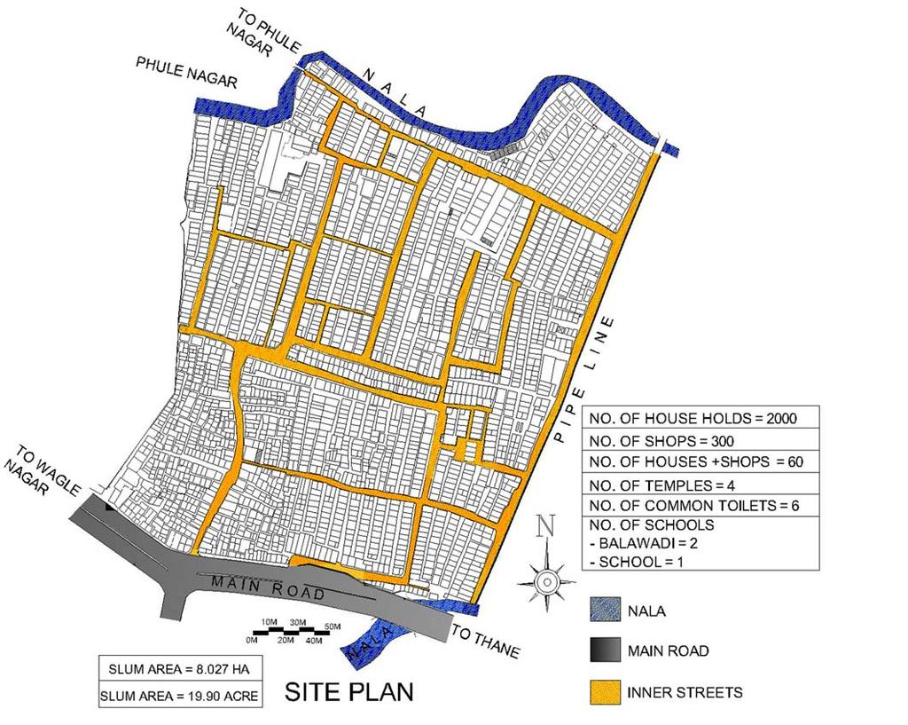
6 Implemented GIS based poverty mapping in Pune in The slums surveyed by SA can be clearly seen spread across 14 administrative Wards. Over households were covered in over 200 slum pockets

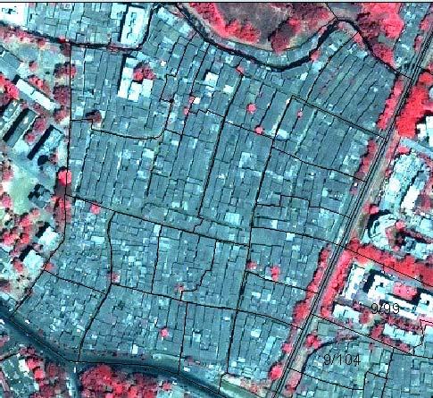
7 Satellite Image in the year 1999


8 household and settlement level surveys carried out by trained slum dwellers plane-table maps of every slum by professional surveyors Integration of spatial and socio economic data on GIS software by SA

9 Settlement info by clicking edge of slum

10 Household information pops up by clicking on any house
11 Type Of Structure
12 Primary Source Of Water Supply
13 Voter ID Card

14 Ownership Of Structure
15 Access to Sanitation

16 Solid Waste Disposal

17 Area of Structure in sq. mts.
18 60.0% 50.0% 52.5% Public Sector (0.8%) Private Sector (2.3%) Self Employed (7.1%) 40.0% 30.0% Skilled Construction Worker (11.3%) Unskilled Construction Worker (52.5%) Professional (0.1%) 20.0% Skilled Labour (4.4%) 10.0% 0.0% 0.8% 2.3% 7.1% 11.3% 9.6% 11.0% 4.4% 0.1% 0.8% Semi-skilled Labour (11.0%) Unskilled Labour (9.6%) Miscellaneous (0.8%) Occupation

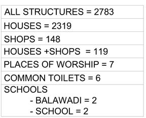
19 Fact Sheet
20 USE OF THE DATA AT THE SETTLEMENT LEVEL

21 Locating Toilet blocks in Panchsheelnagar, CIDCO

22 Kamgar Putla Slum, Pune in Orange which gets flooded every year because it is located by the river Mutha.
23 The houses in blue are on 95 electoral roll and eligible for resettlement.
24 The houses in orange get displaced by the proposed submersible road.

25 The yellow houses displaced by Sangam bridge widening.


26 Before.. After.. Before and After Kamgar Putala. Families have settled down well even after being relocated 8kms from original place of residence.
27 Delivery of Basic Sanitation in slums of Sangli Miraj-Kupwad Corporation SMKMC founded in 1998 by merging 3 municipal councils of Sangli, Miraj and Kupwad In 2001, SA worked with SMKMC to list out all the slums within the municipal limits and carried out a quick survey for each settlement to enlist the services that were present. A fact sheet was created for each slum In 2002, two pilot sanitation projects implemented settlements were identified for sanitation projects covering 3500 families
28 Survey Findings of Phase 1 work in SMKMC The location of all the 99 slums within the SMKMC limits. slumdots zone2 zone1 zone3 zone4
29 Water Distribution in SMKMC SangliWaterlines MirajWaterExt MirajIntWater Wards with good water distribution Wards partly serviced with waterlines Ward with no waterlines Wards with hardly any waterlines
30 Sewage Distribution in SMKMC sewerline MirajSewerLines Wards with good sewer systems Wards with partial sewer systems Wards with no sewerline Wards with hardly any sewersystems An area plan of Sangli-Miraj-Kupwad Corporation showing the existing sewage distribution within the corporation limits.
31 Slum Location in Relation to Sewage Distribution in SMKMC The slums in blue have sewage distribution. There are 78 slums which have no access to toilet facilities.


32 Holding meetings in small groups to enable better participation Building Federations in slums


33 Sanjay Nagar Khaja Vasti Kolhapur Chawl Jatkar Samaj
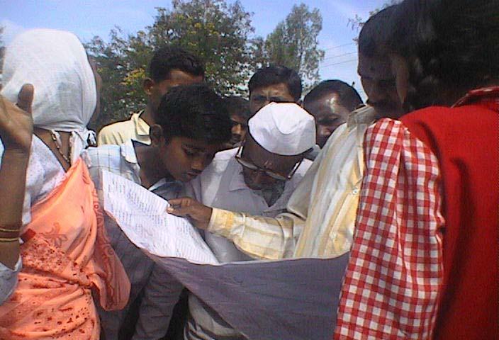
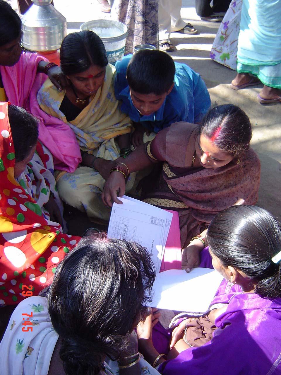
34 Communities studying the Maps and Designs


35 Sharing information and making decisions based on the findings. Meetings with Stakeholders including Municipal Commissioner, officers, councilors and community leaders.
36 The data findings had a major impact on the total project. 1. SA demonstrated that 3 slums could be given the option of individual toilets and this could be accomplished well within the Nirmal Bharat Abhiyan funds that had been approved by the Government. 2. Brought it to the notice of the local government that the 2001 GR allowed NGO s and CBO s to construct toilets in settlements and therefore urged the local govt. not to tender it out to contractors. 3. Got MHADA Mumbai to endorse this in principle.

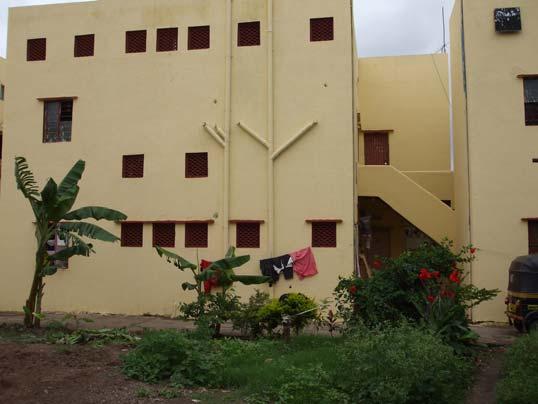
37 Using the Maps and data for locating toilet sites within settlements. Inspecting Kolhapur chawl map to identify space for a community toilet Final location of toilet block The place identified was a very small one and ownership was claimed by a family. SA got the 7/12 extract which showed otherwise and with help of SMKMC claimed the land for the toilet block through legal battle.


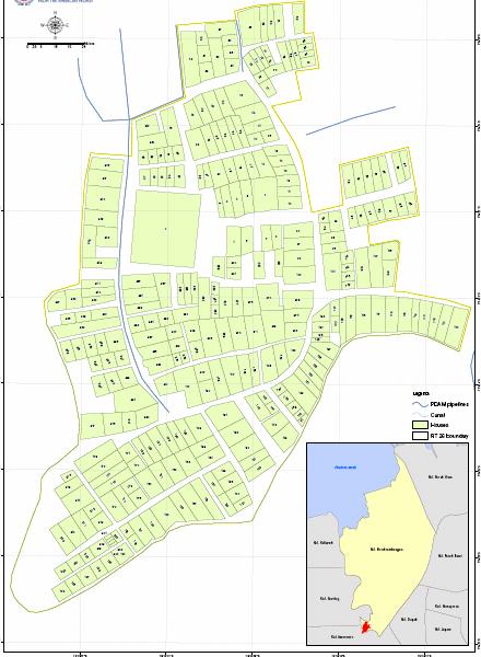
38 A 10 seats toilet block was built in spite of efforts by landowner to physically stall the process. The local Baandhani women ensured that the construction went off without a hitch.


39 The Way Forward The Kids channel The kids channel- formal inauguration by Municipal Commissioner and the local councilor on 8 th January 2008

40 Jatkar before..

41 Jatkar After..
42 Can Remote sensing be used for service delivery?


43 High Tenement densities. With two storied structures it is not possible to view details within slum using remote sensing techniques

44 Dyaneshwarnagar slum Wartak Ward, Thane
45 DYANESHWARNAGAR SLUM PLAN 2320


46 Google image of Settlement AutoCAD map of the same settlement


47 Satellite image indicating 150 structures Autocad map showing 320 structures Remote sensing techniques can give extent of slum and help monitor horizontal expansion over a period of time.

48 Satellite image of Ward Morekrembangan, Surabaya, Indonesia

49 Map by PDAM By Shelter Associates

50 Satellite Aerial Photograph of Ward 45 with GPS Boundary Track superimposed

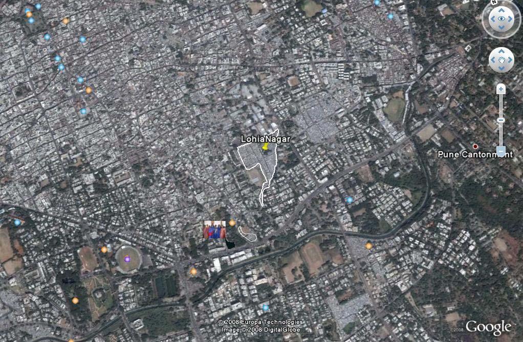
51 Shelter Associates version of map with Slums in position : Dandekar Pul : Dandekar Pul : Indira Nagar 4 : Ramabai Ambedkar 5 : Hirabaug 6 : Sathe Colony 7 : Zagade 8 : Ekbote Colony 9 : Lohiya Nagar 10: Gorpade Peth : Joshi Wada 12 : Ambil Odha 13 : Ghorpadi Peth : Parvati 248


52 Inaccuracies in DP The Ambil-odha is shown flowing straight in the DP whereas it actually curves around the slum.
53 THE WAY FORWARD WITHIN SA
54

55 Superimposing and linking GIS based mapping info on remote sensing images for effective monitoring of growth of slums and effective planning: 1. Ghole Road Ward Office Ward 23 Ward 24 Ward 30 Ward Yerawada Ward Office Ward 3 Ward 11 Ward Sangam Wadi Ward Office Ward 2 Ward 9 Ward 10 Ward 25


56 Google image of Pune wards imported onto GIS platform showing slums. A fact sheet for each slum is flagged onto it.
57
58 ISSUES AND CONCERNS REGARDING USE OF GIS AND REMOTE SENSING TECHNOLOGY by URBAN LOCAL BODIES: Cost of HRSI. Often cities reluctant to invest in these images. Costs of GIS software's: licensed copies dedicated to only one computer. Costs of carrying out detailed mapping and socio economic surveys Frequent changes in administrative head and staff members within departments Scattered information systems between departments using different base maps -bringing them onto one platform
59 Thank You
WORLD COUNCIL ON CITY DATA
 WORLD COUNCIL ON CITY DATA WCCD ISO 37120 STANDARDIZED CITY DATA TO MEET UN SDG TARGETS UN WORLD DATA FORUM Presented by: James Patava www.dataforcities.org @wccitydata PUBLICATION OF THE FIRST ISO STANDARD
DELHI URBAN RESILIENCE PROJECT
 DELHI URBAN RESILIENCE PROJECT Informed citizen-led action improves resilience of high-risk East Delhi communities Photograph SEEDS/ Siddharth Behl Source: The Indian express http//indianexpress.com/article/cities/delhi/unprepared-for-disaster-ten-of-citys-11-districts-prone-to-fires-building-collapse-looms-in-9/#sthash.vheum8rx.dpuf
Together towards a Sustainable Urban Agenda
 Together towards a Sustainable Urban Agenda The City We (Youth) Want Preliminary findings from youth consultations Areas Issue Papers Policy Units 1.Social Cohesion and Equity - Livable Cities 2.Urban
ANALYSING THE DIVERSITY OF DEPRIVED AREAS IN MUMBAI, INDIA
 ANALYSING THE DIVERSITY OF DEPRIVED AREAS IN MUMBAI, INDIA MONIKA KUFFER (M.KUFFER@UTWENTE.NL) KARIN PFEFFER, RICHARD SLIUZAS, ISA BAUD, MARTIN VAN MAARSEVEEN Source: Google Earth CONTENT OF PRESENTATION
The purpose of this report is to recommend a Geographic Information System (GIS) Strategy for the Town of Richmond Hill.
 Strategy for the Town of Richmond Hill.") Staff Report for Committee of the Whole Meeting Department: Division: Subject: Office of the Chief Administrative Officer Strategic Initiatives SRCAO.18.12 GIS Strategy Purpose: The purpose of this report
Staff Report for Committee of the Whole Meeting Department: Division: Subject: Office of the Chief Administrative Officer Strategic Initiatives SRCAO.18.12 GIS Strategy Purpose: The purpose of this report
Diversity of global slum conditions is a universal spatial definition of slums feasible?
 Diversity of global slum conditions is a universal spatial definition of slums feasible? Richard Sliuzas ITC Expert Group Meeting on Slum Mapping 21-23 May 2008 INTERNATIONAL INSTITUTE FOR GEO-INFORMATION
Chapter 10 Human Settlement Geography Book 1 Class 12
 CHAPTER 10 HUMAN SETTLEMENTS 1. RURAL, SUB URBAN AND URBAN SETTLEMENTS: This classification is common worldwide but the criteria differ from country to country. 5. Criteria for classification differs from
Module - 3 GIS MAPPING, MIS AND GIS UNDER RAY
 Module - 3 1 GIS MAPPING, MIS AND GIS MIS INTEGRATION UNDER RAY Role of GIS & MIS under RAY Under the scheme, two step implementation strategy has been adopted i.e. preparation of SFCPoAs on whole city
Local EPM Implementation Process in 5 stages
 Local PM Implementation Process in 5 stages 3. Working groups 1. City nvironmental Profile/ Outlook 5. Consolidation & Institutionalisation 4. Strategy & Action plans 2. City Consultation Urban nvironmental
Community Participation in Land Governance Through Citywide Community Mapping GLTN Learning Exchange, Bayview Hotel, Manila November 7, 2017
 Community Participation in Land Governance Through Citywide Community Mapping GLTN Learning Exchange, Bayview Hotel, Manila November 7, 2017 Community-Led, Citywide Settlement Profiling and Mapping as
Travel behavior of low-income residents: Studying two contrasting locations in the city of Chennai, India
 Travel behavior of low-income residents: Studying two contrasting locations in the city of Chennai, India Sumeeta Srinivasan Peter Rogers TRB Annual Meet, Washington D.C. January 2003 Environmental Systems,
DEBANS - Sanitation CASE STUDY KOLHAPUR
 DEBANS - Sanitation FOR SMALL & MEDIUM TOWNS CASE STUDY KOLHAPUR Bangalore, April 16 th, 2010 Pedro Kraemer BORDA South Asia, Program Coordinator Bremen Overseas Research and Development Association (BORDA)
MODERNIZATION OF THE MUNICIPAL MAPPING USING HIGH END GNSS SYSTEM AND GIS SOFTWARE
 MODERNIZATION OF THE MUNICIPAL MAPPING USING HIGH END GNSS SYSTEM AND GIS SOFTWARE Mr. R. A. R. Khan Assistant Engineer, Sewerage Utility Management Centre (SUMC) Municipal Corporation Of Greater Mumbai
The Use of Geographic Information Systems (GIS) by Local Governments. Giving municipal decision-makers the power to make better decisions
 by Local Governments. Giving municipal decision-makers the power to make better decisions") The Use of Geographic Information Systems (GIS) by Local Governments Giving municipal decision-makers the power to make better decisions Case Study: Examples of GIS Usage by Local Governments in North
The Use of Geographic Information Systems (GIS) by Local Governments Giving municipal decision-makers the power to make better decisions Case Study: Examples of GIS Usage by Local Governments in North
The World Bank Indonesia National Slum Upgrading Project (P154782)
") Public Disclosure Authorized EAST ASIA AND PACIFIC Indonesia Social, Urban, Rural and Resilience Global Practice Global Practice IBRD/IDA Investment Project Financing FY 2017 Seq No: 2 ARCHIVED on 19-May-2017
Public Disclosure Authorized EAST ASIA AND PACIFIC Indonesia Social, Urban, Rural and Resilience Global Practice Global Practice IBRD/IDA Investment Project Financing FY 2017 Seq No: 2 ARCHIVED on 19-May-2017
2 nd Semester. Core Courses. C 2.1 City and Metropolitan Planning. Module 1: Urban Structure and Growth Implications
 2 nd Semester Core Courses C 2.1 City and Metropolitan Planning Module 1: Urban Structure and Growth Implications Growth of cities; cities as engine of growth; urban sprawl; land value, economic attributes
The World Bank Indonesia National Slum Upgrading Project (P154782)
") Public Disclosure Authorized EAST ASIA AND PACIFIC Indonesia Social, Urban, Rural and Resilience Global Practice Global Practice IBRD/IDA Investment Project Financing FY 2017 Seq No: 4 ARCHIVED on 04-Apr-2018
Public Disclosure Authorized EAST ASIA AND PACIFIC Indonesia Social, Urban, Rural and Resilience Global Practice Global Practice IBRD/IDA Investment Project Financing FY 2017 Seq No: 4 ARCHIVED on 04-Apr-2018
Urban Hydrology - A Case Study On Water Supply And Sewage Network For Madurai Region, Using Remote Sensing & GIS Techniques
 RESEARCH INVENTY: International Journal of Engineering and Science ISBN: 2319-6483, ISSN: 2278-4721, Vol. 1, Issue 8 (November 2012), PP 07-12 www.researchinventy.com Urban Hydrology - A Case Study On
Urban dependence on ecosystem services: a spatially explicit analysis of a megacity riverside settlement
 Urban dependence on ecosystem services: a spatially explicit analysis of a megacity riverside settlement Derek Vollmer PhD Candidate (Prof. Dr. Adrienne Grêt-Regamey, advisor) ETH Zürich/Future Cities
GIS Geographical Information Systems. GIS Management
 GIS Geographical Information Systems GIS Management Difficulties on establishing a GIS Funding GIS Determining Project Standards Data Gathering Map Development Recruiting GIS Professionals Educating Staff
International Guidelines on Access to Basic Services for All
 International Guidelines on Access to Basic Services for All Presentation and initials lessons from implementation Accessibility to services in regions and cities : measures and policies, OECD 18 June
URP 701: GENERAL STUDIES
 TOPREC/NITP SYLLABUS 3.0 FINAL EXAMINATION 3.1 PART I URP 701: GENERAL STUDIES Study of Nigeria history, culture and arts in pre-colonial time. Nigerian perception of the world, Culture areas in Nigeria
Route 120 Build-out Analysis Using CommunityViz Scenario 360
 Route 120 Build-out Analysis Using CommunityViz Scenario 360 Jennifer Lingeman CommunityViz Technical Resource Center UNH Complex Systems Research Center jennifer.lingeman@unh.edu NH GRANIT o Central GIS
SA Geospatial Analysis Platform (GAP) Methodology*, collaborators & data sources
 Methodology*, collaborators & data sources") SA Geospatial Analysis Platform (GAP) Methodology*, collaborators & data sources Mesoframe CSIR, dti, the Presidency & GTZ Demarcation of South Africa into a grid of 50 Km 2 mesozones, nested within important
SA Geospatial Analysis Platform (GAP) Methodology*, collaborators & data sources Mesoframe CSIR, dti, the Presidency & GTZ Demarcation of South Africa into a grid of 50 Km 2 mesozones, nested within important
Presented to Sub-regional workshop on integration of administrative data, big data and geospatial information for the compilation of SDG indicators
 Presented to Sub-regional workshop on integration of administrative data, big data and geospatial information for the compilation of SDG indicators 23-25 April,2018 Addis Ababa, Ethiopia By: Deogratius
Space Technology for Implementation of SDGs in the Pacific Region
 Space Technology for Implementation of SDGs in the Pacific Region 13 15 September 2016, Nadi, Fiji Tae Hyung KIM ICT and Disaster Risk Reduction Division (IDD) UNESCAP 1 Contents 1. What are SDGs? How
Role of GIS in Tracking and Controlling Spread of Disease
 Role of GIS in Tracking and Controlling Spread of Disease For Dr. Baqer Al-Ramadan By Syed Imran Quadri CRP 514: Introduction to GIS Introduction Problem Statement Objectives Methodology of Study Literature
Improvements for Kosovo's spatial planning system / [presentation given in May 2011]
![Improvements for Kosovo's spatial planning system / [presentation given in May 2011]](/thumbs/95/122511393.jpg "Improvements for Kosovo's spatial planning system / [presentation given in May 2011]") Rochester Institute of Technology RIT Scholar Works Theses Thesis/Dissertation Collections 2011 Improvements for Kosovo's spatial planning system / [presentation given in May 2011] Luan Nushi Follow this
Rochester Institute of Technology RIT Scholar Works Theses Thesis/Dissertation Collections 2011 Improvements for Kosovo's spatial planning system / [presentation given in May 2011] Luan Nushi Follow this
Measuring Disaster Risk for Urban areas in Asia-Pacific
 Measuring Disaster Risk for Urban areas in Asia-Pacific Acknowledgement: Trevor Clifford, Intl Consultant 1 SDG 11 Make cities and human settlements inclusive, safe, resilient and sustainable 11.1: By
RETA 6422: Mainstreaming Environment for Poverty Reduction Category 2 Subproject
 RETA 6422: Mainstreaming Environment for Poverty Reduction Category 2 Subproject A. Basic Data 1. Subproject Title: Poverty-Environment Mapping to Support Decision Making 2. Country Director: Adrian Ruthenberg
Dr.Sinisa Vukicevic Dr. Robert Summers
 Dr.Sinisa Vukicevic Dr. Robert Summers "Planning" means the scientific, aesthetic, and orderly disposition of land, resources, facilities and services with a view to securing the physical, economic and
GEOGRAPHIC INFORMATION SYSTEMS Session 8
 GEOGRAPHIC INFORMATION SYSTEMS Session 8 Introduction Geography underpins all activities associated with a census Census geography is essential to plan and manage fieldwork as well as to report results
Changing Urban Built-up Area of Sangli-Miraj and Kupwad Municipal Corporation, Maharashtra (India): Using Satellite Data and GIS
: Using Satellite Data and GIS") Changing Urban Built-up Area of Sangli-Miraj and Kupwad Municipal Corporation, Maharashtra (India): Using Satellite Data and GIS Authors & Affiliation: Dr. Pradip Ashok Saymote Assist. Professor, P.G.
Changing Urban Built-up Area of Sangli-Miraj and Kupwad Municipal Corporation, Maharashtra (India): Using Satellite Data and GIS Authors & Affiliation: Dr. Pradip Ashok Saymote Assist. Professor, P.G.
Estimated Amount (Rs.)
") Tender no.-pm/pwd/tender/2013-14/132 Date:- 08/11/13 Sealed Tender Paper in printed form, as specified, are invited by the Chairman, from reliable, resourceful and bonafied Agencies with Sound technical
Tender no.-pm/pwd/tender/2013-14/132 Date:- 08/11/13 Sealed Tender Paper in printed form, as specified, are invited by the Chairman, from reliable, resourceful and bonafied Agencies with Sound technical
COMMUNITY SERVICE AREA
 INSTITUTE FOR TRIBAL ENVIRONMENTAL PROFESSIONALS Tribal Waste and Response Assistance Program (TWRAP) Developing and Implementing a Tribal Integrated Solid Waste Management Plan April 12-14, 2016 Palm
An online data and consulting resource of THE UNIVERSITY OF TOLEDO THE JACK FORD URBAN AFFAIRS CENTER
 An online data and consulting resource of THE JACK FORD URBAN AFFAIRS CENTER THE CENTER FOR GEOGRAPHIC INFORMATION SCIENCE AND APPLIED GEOGRAPHICS DEPARTMENT OF GEOGRAPHY AND PLANNING THE UNIVERSITY OF
Roadmap to Stability
 Landslide Policy Committee for Aizawl City February 2014 Technical Support by: Aizawl is in earthquake hazard zone V and highly prone to natural, man-made and earthquake induced landslides. In order to
Techniques for Science Teachers: Using GIS in Science Classrooms.
 Techniques for Science Teachers: Using GIS in Science Classrooms. After ESRI, 2008 GIS A Geographic Information System A collection of computer hardware, software, and geographic data used together for
Preparing the GEOGRAPHY for the 2011 Population Census of South Africa
 Preparing the GEOGRAPHY for the 2011 Population Census of South Africa Sharthi Laldaparsad Statistics South Africa; E-mail: sharthil@statssa.gov.za Abstract: Statistics South Africa (Stats SA) s Geography
The World Bank Community Development Program Support Project-Phase III (P144637)
") Public Disclosure Authorized AFRICA Cameroon Social, Urban, Rural and Resilience Global Practice Global Practice IBRD/IDA Investment Project Financing FY 2016 Seq No: 5 ARCHIVED on 21-Dec-2017 ISR30226
Public Disclosure Authorized AFRICA Cameroon Social, Urban, Rural and Resilience Global Practice Global Practice IBRD/IDA Investment Project Financing FY 2016 Seq No: 5 ARCHIVED on 21-Dec-2017 ISR30226
A participatory approach to monitoring slum conditions: an example from Ethiopia
 7 A participatory approach to monitoring slum conditions: an example from Ethiopia Background One important prerequisite for improving slum conditions is local intervention strategies that build on adequate
Towards National Geographic Information System in Nepal
 2 nd High Level Forum on Global Geospatial Information Management, Qatar National Convention Centre, Doha, Qatar, 4 6 February, 2013 Towards National Geographic Information System in Nepal Krishna Raj
MODULE 1 INTRODUCING THE TOWNSHIP RENEWAL CHALLENGE
 MODULE 1 INTRODUCING THE TOWNSHIP RENEWAL CHALLENGE FOCUS OF THE MODULE Township renewal challenges and developmental outcomes covered in this module: Historical origins of townships and the inherited
CURRICULUM VITAE Mthobeli Vaaltyn
 CURRICULUM VITAE Mthobeli Vaaltyn 2880 Dwarhane Street Browns Farm Philippi 7785 Cell: 071 3720 456 E-Mail: mvaaltyn4@gmail.com PERSONAL DETAILS Surname First Name(s) : Vaaltyn : Mthobeli Date of Birth
GIS BASED OPTIMAL ROUTE ANALYSIS FOR THE TRANSPORTATION OF SOLID WASTE- A CASE STUDY FROM HYDERABAD CITY
 GIS BASED OPTIMAL ROUTE ANALYSIS FOR THE TRANSPORTATION OF SOLID WASTE- A CASE STUDY FROM HYDERABAD CITY Ramesh Kumar.R 1, Prof. Ch. Ramakrishna 2 1,2 Department of Environmental Studies, GITAM University,
Towards Reliable Spatial Database of Informal Areas in Greater Cairo Region
 KEYWORDS informal areas, unreliable spatial data, spatial data collecting, capacity building SUMMARY The uncontrolled and rapid increase of Egypt s cities is a major problem of the country. More than the
Copernicus Overview. Major Emergency Management Conference Athlone 2017
 Copernicus Overview Major Emergency Management Conference Athlone 2017 Copernicus is a European programme implemented by the European Commission. The services address six thematic areas: land, marine,
Empowering water/wastewater network management with GIS
 Empowering water/wastewater network management with GIS Ioannis Kavouras_GIS Manager Surveying Engineer, MSc, MBA The Company responsible for fresh water distribution & sanitation serving 1.500.000 citizens
The Governance of Land Use
 The planning system Levels of government and their responsibilities The Governance of Land Use COUNTRY FACT SHEET NORWAY Norway is a unitary state with three levels of government; the national level, 19
Bishkek City Development Agency. Urban Planning Bishkek
 Bishkek City Development Agency Urban Planning Bishkek Bishkek City Development Agency Official name City budget Population Area GRP Import value Export value External trade turnover Foreign direct investments
UNITED NATIONS E/CONF.96/CRP. 5
 UNITED NATIONS E/CONF.96/CRP. 5 ECONOMIC AND SOCIAL COUNCIL Eighth United Nations Regional Cartographic Conference for the Americas New York, 27 June -1 July 2005 Item 5 of the provisional agenda* COUNTRY
Achieving the Vision Geo-statistical integration addressing South Africa s Developmental Agenda. geospatial + statistics. The Data Revolution
 Achieving the Vision Geo-statistical integration addressing South Africa s Developmental Agenda geospatial + statistics The Data Revolution humble beginnings, present & future - South Africa UN World Data
Asia Pacific Ministerial Conference on Housing and Urban Development (APMCHUD) Meeting of the Working Group on Urban and Rural Planning and Management
 Meeting of the Working Group on Urban and Rural Planning and Management") Asia Pacific Ministerial Conference on Housing and Urban Development (APMCHUD) Meeting of the Working Group on Urban and Rural Planning and Management August 16 17, 2012 New Delhi Recommendations of the
Asia Pacific Ministerial Conference on Housing and Urban Development (APMCHUD) Meeting of the Working Group on Urban and Rural Planning and Management August 16 17, 2012 New Delhi Recommendations of the
A/Prof. Mark Zuidgeest ACCESSIBILITY EFFECTS OF RELOCATION AND HOUSING PROJECT FOR THE URBAN POOR IN AHMEDABAD, INDIA
 A/Prof. Mark Zuidgeest ACCESSIBILITY EFFECTS OF RELOCATION AND HOUSING PROJECT FOR THE URBAN POOR IN AHMEDABAD, INDIA South African Cities Network/University of Pretoria, 09 April 2018 MOBILITY Ability
URBAN LAND USE STRATEGIES AND INFRASTRUCTURE PROVISION IN AHMEDABAD CITY
 URBAN LAND USE STRATEGIES AND INFRASTRUCTURE PROVISION IN AHMEDABAD CITY 1 HARSH M PATEL, 2 BHUPENDRA M MARVADI 1 Student, M.E. Infrastructure Engineering, Dept. of Civil Engineering, L.D.R.P. Institute
Diffusion of GIS in Public Policy Doctoral Program
 Diffusion of GIS in Public Policy Doctoral Program By Fulbert Namwamba PhD Southern University This presentation demonstrate how GIS was introduced in the Public Policy Doctoral Program at Southern University,
MPOs SB 375 LAFCOs SCAG Practices/Experiences And Future Collaborations with LAFCOs
 Connecting LAFCOs and COGs for Mutual Benefits MPOs SB 375 LAFCOs SCAG Practices/Experiences And Future Collaborations with LAFCOs Frank Wen, Manager Research & Analysis Land Use & Environmental Planning
ANGOLA: PARTICIPATORY MAPPING OF URBAN POVERTY. By Allan Cain, Development Workshop
 ANGOLA: PARTICIPATORY MAPPING OF URBAN POVERTY By Allan Cain, Development Workshop Angola: Participatory Mapping of Urban Poverty BY ALLAN CAIN, DEVELOPMENT WORKSHOP This paper explains a method for measuring
Land Use in the context of sustainable, smart and inclusive growth
 Land Use in the context of sustainable, smart and inclusive growth François Salgé Ministry of sustainable development France facilitator EUROGI vice president AFIGéO board member 1 Introduction e-content+
Preparation of Database for Urban Development
 Preparation of Database for Urban Development By PunyaP OLI, 1. Chairman, ERMC (P) Ltd., Kathmandu, Nepal. Email: punyaoli@ermcnepal.com 2. Coordinator, Himalayan College of Geomatic Engineering and Land
The World Bank Tamil Nadu Sustainable Urban Development Program (P150395)
") Public Disclosure Authorized SOUTH ASIA India Social, Urban, Rural and Resilience Global Practice Global Practice IBRD/IDA Investment Project Financing FY 2015 Seq No: 6 ARCHIVED on 02-Dec-2017 ISR29908
Public Disclosure Authorized SOUTH ASIA India Social, Urban, Rural and Resilience Global Practice Global Practice IBRD/IDA Investment Project Financing FY 2015 Seq No: 6 ARCHIVED on 02-Dec-2017 ISR29908
DBSA Knowledge Week Yusuf Patel South African Planning Institute
 Sustainable Human Settlements - Institutional Issues DBSA Knowledge Week Yusuf Patel South African Planning Institute 20 October 2010 Spatial Planning for Long Term Apartheid engineered spatial economy
New Prospects for Peripheral Rural Regions Helmut Hiess Glasgow, 19th of May 2010
 New Prospects for Peripheral Rural Regions Helmut Hiess Glasgow, 19th of May 2010 ÖROK: Organisation & Tasks Austrian Conference on Spatial Planning (ÖROK, since 1971): Joint organisation by Federal level,
Open Cities Project. The World Bank, South Asia Region. Background
 Open Cities Project The World Bank, South Asia Region Opencitiesproject.com Background The World Bank s South Asia Region (SAR) is proud to announce its new Open Cities Project. The goal of this project
Corporate. Information. Railway Infrastructure Administrator. Year indracompany.com
 geospatial and mobility Corporate Geographic Information System of ADIF Railway Infrastructure Administrator. Year 2009-2010 Corporate Geographic Information System of ADIF ADIF. Spanish Administrator
Charles N. MUNDIA 1 and Eunice W. NDUATI 2
 Charles N. MUNDIA 1 and Eunice W. NDUATI 2 1 Dedan Kimathi University of Technology 2 Jomo Kenyatta University of Agriculture and Technology Abstract: Urbanization in numerous developing countries is occurring
Weather Climate Science to Service Partnership South Africa
 PROJECTS UNDERWAY Title of the Weather Climate Science to Service Partnership South Africa Together, building on an existing strong partnership, South African Weather Service and the Met Office will build
Establishment of WINDS Ground Station in Sri Lanka. By G.K.D. Amarawardena Additional Secretary Ministry of Disaster Management Sri Lanka
 Establishment of WINDS Ground Station in Sri Lanka By G.K.D. Amarawardena Additional Secretary Ministry of Disaster Management Sri Lanka Contents Background SAS Implementation Progress of WINDS establishment
Policy Note 6. Measuring Unemployment by Location and Transport: StepSA s Access Envelope Technologies
 6 Measuring Unemployment by Location and Transport: StepSA s Access Envelope Technologies Introduction Increasing emphasis is coming onto spatial planning as government in South Africa moves to address
Legal problems of environmental management. Spatial planning and space management. M. Gajewski 2014 / 2015
 Legal problems of environmental management Spatial planning and space management M. Gajewski 2014 / 2015 Course contents (in brief) Constitutional basis of the environment protection system. General principles
About the Author: UID data in SPRS profiler. Representation code. Character. STATE OF INDIA Census code of UID-1
 Formulation of Policy & strategies for slum development through Slum Permanent Record System with GIS as E-TOOL Hema Dudhwala Founder and Principal of SPRS Research foundation Director& Proprietor of AAPIL
Cartographic Division Proposal
 Cartographic Division Proposal Steve Henderson, Public Works Engineer Background The City of Gulf Shores is expected to purchase or lease additional buildings across the street from City Hall to accommodate
The World Bank Community Development Program Support Project-Phase III (P144637)
") Public Disclosure Authorized AFRICA Cameroon Social, Urban, Rural and Resilience Global Practice Global Practice IBRD/IDA Investment Project Financing FY 2016 Seq No: 6 ARCHIVED on 27-Jun-2018 ISR33107
Public Disclosure Authorized AFRICA Cameroon Social, Urban, Rural and Resilience Global Practice Global Practice IBRD/IDA Investment Project Financing FY 2016 Seq No: 6 ARCHIVED on 27-Jun-2018 ISR33107
A Summary of State DOT GIS Activities. Presented at the 2000 AASHTO GIS-T Symposium Minneapolis, MN
 A Summary of State DOT GIS Activities Presented at the 2000 AASHTO GIS-T Symposium Minneapolis, MN Information Sources E-mail survey of state DOT GIS managers 49 State DOTs responded in 2000 Results compared
Urbanization and Sustainable Development of Cities: A Ready Engine to Promote Economic Growth and Cooperation
 Urbanization and Sustainable Development of Cities: A Ready Engine to Promote Economic Growth and Cooperation Wan Portia Hamzah Institute of Strategic and International Studies (ISIS) Malaysia 10 September
Public Participatory GIS (ppgis), training & webgis in Mare Nostrum. Anna Spiteri, IRMCo Haifa, Israel, 5th March 2013
, training & webgis in Mare Nostrum. Anna Spiteri, IRMCo Haifa, Israel, 5th March 2013") Public Participatory GIS (ppgis), training & webgis in Mare Nostrum Anna Spiteri, IRMCo Haifa, Israel, 5th March 2013 What is ppgis? Why do we need it? Who participates? Where do we do it? When do we do
Public Participatory GIS (ppgis), training & webgis in Mare Nostrum Anna Spiteri, IRMCo Haifa, Israel, 5th March 2013 What is ppgis? Why do we need it? Who participates? Where do we do it? When do we do
National Spatial Development Perspective (NSDP) Policy Coordination and Advisory Service
 Policy Coordination and Advisory Service") National Spatial Development Perspective (NSDP) Policy Coordination and Advisory Service 1 BACKGROUND The advances made in the First Decade by far supersede the weaknesses. Yet, if all indicators were
National Spatial Development Perspective (NSDP) Policy Coordination and Advisory Service 1 BACKGROUND The advances made in the First Decade by far supersede the weaknesses. Yet, if all indicators were
GEOMATICS SURVEYING AND MAPPING EXPERTS FOR OVER 35 YEARS
 GEOMATICS SURVEYING AND MAPPING EXPERTS FOR OVER 35 YEARS 2 GEOMATICS AND SURVEYING SOLUTIONS SPANNING THE ENTIRE PROJECT LIFECYCLE 1,000+ 250+ 24 Surveying professionals Active field crews Geomatics offices
ENVIRONMENTALLY ORIENTED PLANNING FOR HUMAN SETTLEMENTS
 40 TOPIC 7 ENVIRONMENTALLY ORIENTED PLANNING FOR HUMAN SETTLEMENTS Scope The process of rapid population growth and urbanization taking place in practically all the less developed countries will have an
Write a report (6-7 pages, double space) on some examples of Internet Applications. You can choose only ONE of the following application areas:
 on some examples of Internet Applications. You can choose only ONE of the following application areas:") UPR 6905 Internet GIS Homework 1 Yong Hong Guo September 9, 2008 Write a report (6-7 pages, double space) on some examples of Internet Applications. You can choose only ONE of the following application
UPR 6905 Internet GIS Homework 1 Yong Hong Guo September 9, 2008 Write a report (6-7 pages, double space) on some examples of Internet Applications. You can choose only ONE of the following application
E Geographic Information System. Created By: Freda Rocker Pearl River County Mapping
 E-9-1-1 Geographic Information System Created By: Freda Rocker Pearl River County Mapping frocker@pearlrivercounty.net Overview of Pearl River County E-9-1-1 Communications District GIS In 1998 the Pearl
Author(s): Charles K. Cover, P.E. Federal Energy Regulatory Commission
: Charles K. Cover, P.E. Federal Energy Regulatory Commission") Using GIS to Help Manage a National Energy Program Author(s): Charles K. Cover, P.E. Federal Energy Regulatory Commission The Federal Energy Regulatory Commission (FERC) has statutory oversight on key
Using GIS to Help Manage a National Energy Program Author(s): Charles K. Cover, P.E. Federal Energy Regulatory Commission The Federal Energy Regulatory Commission (FERC) has statutory oversight on key
The World Bank Tamil Nadu Sustainable Urban Development Program (P150395)
") Public Disclosure Authorized Public Disclosure Authorized Public Disclosure Authorized Public Disclosure Authorized SOUTH ASIA India Social, Urban, Rural and Resilience Global Practice Global Practice
Public Disclosure Authorized Public Disclosure Authorized Public Disclosure Authorized Public Disclosure Authorized SOUTH ASIA India Social, Urban, Rural and Resilience Global Practice Global Practice
The Current Status and Reform Strategies of GIS Projects for Urban Infrastructure Management in Korea
 The Current Status and Reform Strategies of GIS Projects for Urban Infrastructure Management in Korea Prof. CHOI Yun-Soo and KOH June-Hwan, Republic of Korea Key words: GIS, Urban Infrastructure, Underground
SDI Development in Georgia. Mari Khardziani Head of International Relations Unit National Agency of Public Registry
 SDI Development in Georgia Mari Khardziani Head of International Relations Unit National Agency of Public Registry Kehl, Germany September 5, 2017 2 National Agency of Public Registry Legal Entity of Public
John A. Ritter, Ph.D. Oregon Institute of Technology
 Oregon Institute of Technology Department t of Geomatics A GIS Degree That Merges GIS with Surveying Presented By Presented By John A. Ritter, Ph.D. Oregon Institute of Technology Presentation Objectives
The project, born from an idea of the Provincial College of the Surveyors of Trapani and from the synergy between the administration of Mazara del
 The project, born from an idea of the Provincial College of the Surveyors of Trapani and from the synergy between the administration of Mazara del Vallo, with the Surveyors Professional Organizations :
- facilitate the preparation of landslide inventory and landslide hazard zonation maps for the city, - development of precipitation thresholds,
 Date of Submission 29.03.2012 IPL Project Proposal Form 2012 (MAXIMUM: 3 PAGES IN LENGTH) 1. Project Title: (2 lines maximum)-introducing Community-based Early Warning System for Landslide Hazard Management
Thoughts toward autonomous land development. Introduction
 Thoughts toward autonomous land development Spatial Transformation of Regular grid Irrigation Frameworks Bangkok and Cairo A Work in Progress Information based on student workshop June 2009 and earlier
REPORT ON INVESTMENTS
 REPORT ON INVESTMENTS D.T2.3.3 Investments for technical equipment for the implementation of Web-GIS platform in Mantova 1 Local support group designing Mantova Web-GIS platform. Picture by Maria Giulia
RESTRUCTURING PAPER ON A PROPOSED PROJECT RESTRUCTURING LK WATER SUPPLY AND SANITATION IMPROVEMENT PROJECT APPROVED ON JUNE 24, 2015
 Public Disclosure Authorized The World Bank REPORT NO.: RES33110 Public Disclosure Authorized RESTRUCTURING PAPER ON A PROPOSED PROJECT RESTRUCTURING OF Public Disclosure Authorized LK WATER SUPPLY AND
GIS Streamlines Carlton s Sewer Improvement Process Presented by: John M. Langhans, PE Jared W. DeMaster, PE MSA Professional Services, Inc.
 GIS Streamlines Carlton s Sewer Improvement Process Presented by: John M. Langhans, PE Jared W. DeMaster, PE MSA Professional Services, Inc. November 21, 2013 APWA Conference, Brooklyn Park, MN MSA Professional
Vanessa Nadalin Lucas Mation IPEA - Institute for Applied Economic Research Regional Studies Association Global Conference Fortaleza 2014
 Spatial distribution of sanitation and income inequality in Brazilian Slums Vanessa Nadalin Lucas Mation IPEA - Institute for Applied Economic Research Regional Studies Association Global Conference Fortaleza
How GIS can be used for improvement of literacy and CE programmes
 How GIS can be used for improvement of literacy and CE programmes Training Workshop for Myanmar Literacy Resource Center (MLRC) ( Yangon, Myanmar, 11 20 October 2000 ) Presented by U THEIN HTUT GEOCOMP
MALDIVES. Regional Expert Workshop On Land Accounting For SDG Monitoring & Reporting (25-27 th Sept 2017) - Fathimath Shanna, Aishath Aniya -
 - Fathimath Shanna, Aishath Aniya -") MALDIVES Regional Expert Workshop On Land Accounting For SDG Monitoring & Reporting (25-27 th Sept 2017) - Fathimath Shanna, Aishath Aniya - ABOUT MALDIVES Approximately 860 km long and 120 km wide Consists
MALDIVES Regional Expert Workshop On Land Accounting For SDG Monitoring & Reporting (25-27 th Sept 2017) - Fathimath Shanna, Aishath Aniya - ABOUT MALDIVES Approximately 860 km long and 120 km wide Consists
The purpose of this paper is to explain the concept
 THE INTER-DIMENSIONAL ANALYSIS OF URBAN DEVELOPMENT: A Guide to the Organisation of Cases and Their Linkages by Michael Safier Development Planning Unit (DPU) University College London Michael Safier 2001
ITHUBA COMMUNITY CENTRE BLACKBURN VILLAGE SOCIAL SUSTAINABLE INTERGRATED PROGRAM
 Response to How the City s approached on attaining Urban Opportunities, Social Capital through meaningful collaborations & partnerships that places people at the heart. ITHUBA COMMUNITY CENTRE BLACKBURN
Favorable potential zone map using Remote sensing and GIS
 Favorable potential zone map using Remote sensing and GIS M. Devarajan & S.Mohan GIS Cell, Hydrogeology Wing Tamilnadu Water Supply and Drainage Board, Chennai Abstract: TWAD Board is shouldering the responsibility
What s Happening in My Watershed?
 What s Happening in My Watershed? How Implementing a GIS system to Utilize Spatial Data and Digital Collection Techniques can help Solve Watershed Issues. Mindi J. Parsell City of Tulsa Stormwater Quality
Assessment of Directed Land Use Development in Chennai Metropolitan Area
 85 Journal on Design and Manufacturing Technologies, Vol.1, No.1, November 2007 Assessment of Directed Land Use Development in Chennai Metropolitan Area 1 2 Sampath Kumar V, Helen Santhi M 1 2 Professor,