Customized Mapping Solutions
|
|
|
- Candice Woods
- 6 years ago
- Views:
Transcription


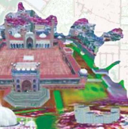
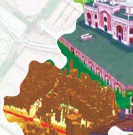
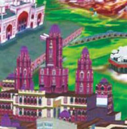
1 Customized Mapping Solutions Hydrography Transportation Building Property Database Utilities Cadastre Landuse/Landcover Elevation Layers Administrative Boundaries


2 DELHI GOVERNMENT TEAM DELHI-MAKING THINGS HAPPEN DoIT Govt. of NCT of Delhi

3 Commitment towards g-governance 01 Geospatial Delhi Limited as a geo-knowledge enterprise of the Government of Delhi with its expertise in the domain of GIS ensures the utilization of its proficiency to propose ideas/concepts & conversion of the same into effectively implemented solutions for the g-governance. GSDL aims to gear up the capital to pioneer for the effective and successful implementation of the g-governance initiatives thus portraying the country as a lead example in the arena. This would not only ornament the country's facades geospatially but also highlight it on the Geospatial map of the world. Our Experience with the DSSDI dataset 02 Utilization of DSSDI data set for applications in various g-governance initiatives has enriched the organizations experience in the domain. Listed below are a few ongoing projects/services being taken up by GSDL: System for Maintenance and Updation of Spatial Infrastructure of Delhi Jal Board (DJB) assisted by Field Sheets There is a regular process of updation of GIS data in Delhi Jal Board and about 500 such cases of maintenance, asset creation & liable updations are reported annually in the department. This process requires mapping of assets on field and updation as GIS database. GSDL initiated the creation, printing & submission of DJB utility maps on three levels viz. division-wise, ward-wise and field sheets on 1:1,000 scale which will be used by DJB field staff for planning and maintenance purpose. These field sheets will be the base for the utility data updation mechanism. The further updation of assets will be marked on these sheets by the DJB field staff. They can also show their planning alternatively on these sheets. The proposed mechanism will form the cyclic process of updation in the department. Underground/Overground utilities of Delhi Jal Board: Division: Southwest-I, Zone: Southwest -I

4 East Delhi Municipal Corporation Collection of property tax is a major source of revenue for the local government. The gaps in the tax collection could be Geospatially assessed which could assist in a precise estimation of the same. With this objective in mind, a project- Joint validation of Geospatial property data and the MCD linked data with (East Delhi Municipal Corporation)EDMC tax inspector and legacy digitization of EDMC property ledger is being carried out for EDMC. Steps for joint validation of DSSDI and MCD data includes correlation of DSSDI building & building unit data with MCD ledger data & data of online tax payer; Map of Geeta Colony, Block-14 showing the status of property tax paid or not paid. digitization of tax paid history from MCD ledger and updation of online tax payer information to DSSDI data. Through this information status list of tax payers is prepared. To ease the visualization of tax payer location, block wise or colony wise map has been prepared. After spatial joining and sorting of data, analysis is being done on each and every individual record to identify the status category as Tax Paid & Not Paid based upon criteria as suggested by EDMC. Regularization of Unauthorized Colonies The utilization of the Geospatial database for the delineation of the unauthorized colony boundaries and regularization of the same by the GNCTD is a commendable example of its type. The unauthorized colony boundaries are delineated based on the defined guidelines and subsequently the maps are composed and submitted to the Urban Development Authority along with the built-up percentage of the colony. Temporal aerial photographs are being used for features / calculation of built-up percentage. This work is being carried out for approximately 1650 colonies of Delhi. The colonies are being considered for regularization, as per the guidelines which are based upon the built up percentage of the colony in the defined term. The application of the dataset in defining the re-development strategy for the colonies is also proposed and is under consideration.
. The high resolution database of GSDL coupled with secondary data availed from other stake holders are extensively being used.")
5 Zone 'O' Mapping Map showing the distribution of 895 colonies regularised in phase-1 GSDL is support party of Management Action Group (MAG) on Environment Planning & Coordination of MPD-2021 to prepare a plan of Yamuna river bed in Delhi (Zone O of MPD-2021). The high resolution database of GSDL coupled with secondary data availed from other stake holders are extensively being used. Highest flood level (207m) mapping around Old Delhi Railway Bridge Master Plan of Drainage in Delhi GSDL is actively coordinating with IIT Delhi and Department of Irrigation & Flood Control for preparing the Drainage Master Plan of the city.


6 PDM Application PDM is a unique combination of an industry standard server supporting an open source in-house code intended to facilitate different engineering departments of Delhi Govt. to plan the excavation; safely dig an area of any place and monitor the progress of the activity till the project is over and get historical excavation data or reports. This application is to ease the departments for planning and getting utility and spatial information of the area of interest. The application ultimately aims a smooth coordination among the stakeholders; to save time, money and effort and at the same time reduces the risk considerably. The next phase of the application for online enrollment of contractors and granting permission on a single window interface is in progress. Capacity building to ensure efficient and transparent g-governance Outreach Activities Hon ble Lt. Governor addressing the Students With the aim to enhance Geo-Literacy and promote geographical thinking ability among the masses GSDL conducts various training sessions and other outreach activities for a versatile level of users which could include domain experts from the departments to the school going students. The workshop Sensitizing schools with the versatility of GIS conducted for the school students to honor the concurrence of GIS Day with the Children's day on November 14, 2012 is an example of the same.
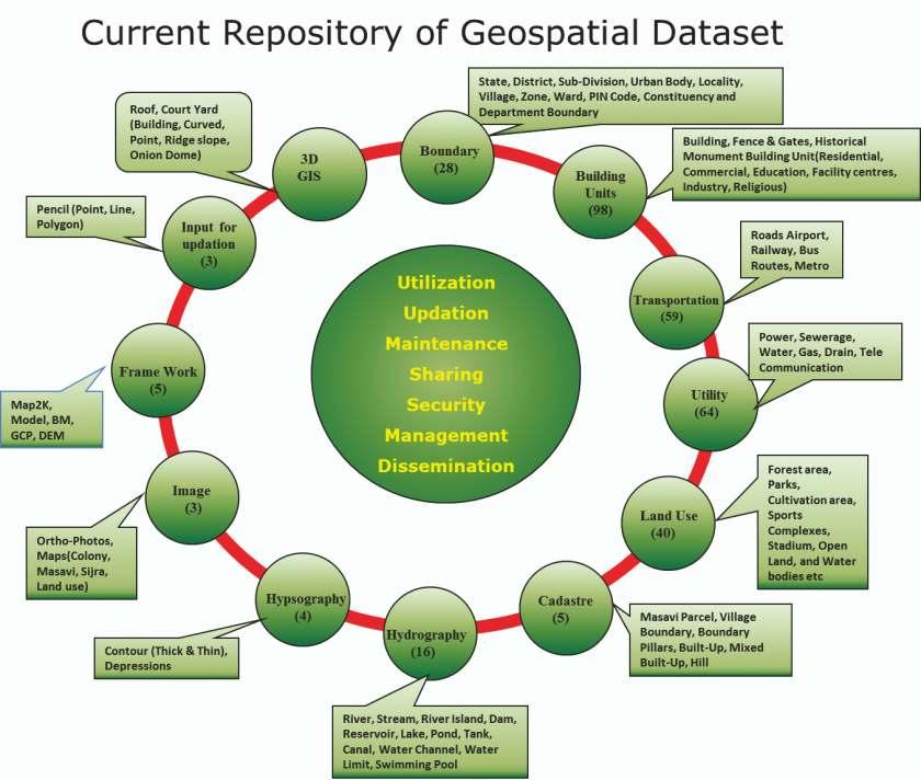
7 03 Our Strength As per the Delhi Geospatial Data Infrastructure Act 2011, Geospatial Delhi Limited is the custodian of the affluent database prepared during the Delhi State Spatial Data Infrastructure project. The project has bestowed Delhi with an extremely rich database with all the infrastructure and facilities of the city mapped at a scale of 1:2000. Geospatial Delhi Limited formulated initially as a Special Purpose Vehicle to assist the project is now empowered as a company and is the custodian of DSSDI database. The base strength of the organization lies in the combination of rich heritage of DSSDI data and a versatile pool of across the domain resources with their core specialization in GIS. Experience for prototyping and implementing Geo-Governance in Delhi enable us to be a prominent consultant in the field. Our Approach Government Department Nodal Officers Geospatial Delhi Limited Requirement Analysis 04 Proof of Concept Technical Proposal Rich DSSDI Database/ Simulated DSSDI Database GSDL proposes to expand its presence to every nook and corner of the country through strategic partnership with companies and the state government. 05 About GSDL Geospatial Delhi Limited is a geo-knowledge enterprise of the Govt. of NCT of Delhi, empowered as per the Delhi Geospatial Data Infrastructure Act on 1st August 2012 through a notification by the order of Lt. Governor of the National Territory of Delhi (NCTD). Geospatial Delhi Limited is a Government of Delhi Company with the authorized share capital of 150,00,00,000/- (Rupees One Hundred Fifty Crore) divided into 15,00,00,000 (Fifteen Crore) equity shares of Rs. 10/-(Rupees Ten) each. GSDL is registered under companies act, 1956.
8 The Delhi Geospatial Act 06 The Delhi Geospatial Data Infrastructure (management control, administration, security and safety) Act, 2011was passed by the Legislative Assembly of National Capital Territory of Delhi on 23rd March, It received the assent of Lt. Governor of Delhi on 6th April 2011 and came into force from 1st March, Maintenance and updation of geospatial data Responsibilities of GSDL as per the Delhi Geospatial Data Infrastructure Act, 2011 Developing geo-portal and applications pertaining to the usage of geospatial data for the various departments and the citizens of Delhi Providing value added and consultancy services to the Government Management and sharing of geospatial data by GSDL Utilization of geospatial data at the same time ensuring its safety and security Support various line departments to update the attributes pertaining to them Monitor and regulate any excavation/de velopmental activity by any contractor/ department This act lays down the foundation to monitor and regulate online, any excavation work or developmental activity carried on by any contractor or department, be it private or government, in the entire capital. Board of Directors Board of Directors is the governing body of the organization. The Directors of the company are the secretary level officials from various stakeholder departments, nominated from time to time by the Government of Delhi. Chairperson GNCTD is the Chairman of GSDL and Managing Director being the key functionary. 07 Products & Services Map Products Data Products Analysis/Modeling Results G-governance solutions Customized Software Applications Tablet Customization GIS Consultancy Training & Capacity Building


9 Core Competencies e/g-governance Solutions Application Development Mapping and Surveying Capacity Building Aerial/GPS/TS Survey System Integration Position and Navigation GIS Solution and Services Strategic Consulting Project Management Web GIS Applications Database Services Photogrammetric Solutions Remote Sensing Solutions 08 Domains of Expertise GSDL offers specialized GIS Solutions in the following domains. These domains have been derived through clubbing a set of stakeholder departments and are led as the verticals of the organization: Utility Management Cluster specializes in the domain and supports various utility companies covering the areas of gas distribution/ transmission, electric distribution/ transmission, telecommunications, cable and water/ sewer. Our team is a blend of technological know-how for digital mapping from variety of sources including satellite images, aerial photographs, GPS field data and existing maps leading to the GIS database creation and analysis and modeling of the same for various utility projects. 3D projected view a) Over ground b) Under ground
10 Land and Property Cluster specializes in the Geospatial Solutions for Land & Property related departments like Delhi Development Authority, Revenue Department, Municipal Corporation of Delhi & Forest and Wild life. The cluster constitutes a team of technical domain experts and offers cutting edge geospatial solutions for land development, planning, property tax and forest & ecology. Urban planning and development Municipal services Property taxation Geospatial Solutions for Land and Property Integrated LIS Encroachment and change detection Urban sprawl mapping Transport/Navigation Applications team constitutes Geospatial experts with experience in road network analysis and data preparation associated with traffic management. The team also provides specialist services in respect of the highway, traffic and parking aspects of development planning. The versatile database of the DSSDI project and the experiments on the same for the conceptualization of projects and services also ornaments the organizations expertise in various multi modal navigation applications. Transportation planning and traffic management. Spatial accessibility Geospatial Solutions for Transport and Navigation Navigation applications Multi modal route planning
11 Infrastructure &Taxation team is an amalgam of GIS experts to support the community redevelopment initiatives in a way that revitalizes the economic and environmental health of neighborhoods. Maintenance of Existing Infrastructure Site Suitability Assessment and Planning Assessment of Environmental Impact by mega structures Designing Sustainable Infrastructures Social Sector Services team facilitates geographically enabled decision making and location allocation factor in the social space. An efficient system of governance requires geographically referenced information of various cultural aspects of the society like health facilities, public distribution system, educational system etc. which assist the economic development and facility management. The cluster is aligned to define and suggest an operative approach for the dissemination of the cultural resources in the society. Facility management Resource allocation Geospatial Applications in Social Sector Planning Socio-economic planning Social media integration and networking Demographic Services: The stakeholders of the cluster include departments dealing with statistics of human population like the electoral and the census departments. The cluster offers expert solutions for demographic analysis and offers end to end geospatial solutions that might include tablet applications for survey to desktop applications for analysis which might assist in various administrative and planning purposes like new boundary delineations, modifications of the existing boundaries based on demographics and interdepartmental boundary reconciliation. Geospatial Solutions for Demographic Services Tablet Based Survey Migration Transition Demographic Profiling Representation and Analysis of Population size


12 Emergency Services: Emergency Services cluster deals with Geospatial services in the domain of disaster management which include information generation, data updation and designing decision support system etc. The skilled team specializing in the domain of use of Geospatial technology in Disaster Management offers solutions for disaster planning based upon the real world situation. Land inundation with the rise of water level Environment Clearance Services: Environment Clearance Services cluster capitalizes the capabilities of the Geospatial Technologies to solve a wide range of environmental problems, which are mostly related to urban areas and of anthropogenic origin. The cluster is entitled to carry out mapping, analysis and modeling of spatio-temporal data for the concerned Govt. departments to assist in planning, assessment and protection of the environment. Solid Waste Dumping Site in Ghazipur


13 Capacity Building and Outreach: The team comprises of a pool of experts from different domains and is engaged in various capacity building and outreach activities primarily focusing upon the usage and applications of geospatial database and its various analytical applications to serve different work groups. The intent is basically to generate interest among people towards the usage and prospective applications of Geospatial technologies in their routine work and create a pool of expert professionals in the domain. Various Seminars and Workshops Organized by Geospatial Delhi Limited Operations and Data Management Services: The team constitutes of experts with experience in core GIS data handling and is responsible for maintaining and updating the versatile database inherited from the DSSDI project. Systems and Software Development: The company maintains stateof-the-art System and Software development centre equipped with enterprise leading-edge hardware, software and networking infrastructures and is involved in developing and maintaining high end applications to support the governance related decisions made by the Government of Delhi. It is also developing high end applications for utilization of DSSDI data for a number of citizen centric services. GSDL is committed to take all necessary steps for furthering the cause of g-governance.
14


15 Our Stakeholders
16 Geospatial Delhi Limited (GSDL) rd 3 Level, 'C' Wing, Vikas Bhawan-II, Civil Lines, New Delhi Ph: , Fax No , geo.spatial.delhi@gmail.com exposition.consultants@gmail.com
COUNTY SPATIAL DATA INFRASTRUCTURE PRESENTATION: BY: GEOFREY CHERUIYOT NAIROBI CITY COUNTY
 . COUNTY SPATIAL DATA INFRASTRUCTURE PRESENTATION: BY: GEOFREY CHERUIYOT NAIROBI CITY COUNTY FRAMEWORK FOR AN INTEGRATED SPATIAL DATA INFRASTRUCTURE County GIS GIS : A computer based information system
GIS Monroe Geographic Information System March 14, 2018
 GIS Monroe Geographic Information System March 14, 2018 Goals Maintain Enterprise/County-wide geo-database Increase spatial accuracy of data Build and acquire more data layers Increase use of GIS; as another
Geospatial SDI Portal for effective Governance of Pune METROPOLIS region
 Geospatial SDI Portal for effective Governance of Pune METROPOLIS region Mr. Praveen Gautam Senior Manager 19 th January 2018 PMRDA Overview Provide a Spatial Framework for the entire region with various
GEOGRAPHIC INFORMATION SYSTEMS Session 8
 GEOGRAPHIC INFORMATION SYSTEMS Session 8 Introduction Geography underpins all activities associated with a census Census geography is essential to plan and manage fieldwork as well as to report results
Preparation of Database for Urban Development
 Preparation of Database for Urban Development By PunyaP OLI, 1. Chairman, ERMC (P) Ltd., Kathmandu, Nepal. Email: punyaoli@ermcnepal.com 2. Coordinator, Himalayan College of Geomatic Engineering and Land
Oman NSDI Business Values and Future Directions. Hassan Alawi Alghazali Acting Director General National Spatial Data Infrastructure
 Oman NSDI Business Values and Future Directions Hassan Alawi Alghazali Acting Director General National Spatial Data Infrastructure Presentation Outline Geospatial Maturity Current Challenges NCSI s Role
GEOMATICS. Shaping our world. A company of
 GEOMATICS Shaping our world A company of OUR EXPERTISE Geomatics Geomatics plays a mayor role in hydropower, land and water resources, urban development, transport & mobility, renewable energy, and infrastructure
CHAPTER 22 GEOGRAPHIC INFORMATION SYSTEMS
 CHAPTER 22 GEOGRAPHIC INFORMATION SYSTEMS PURPOSE: This chapter establishes the administration and use of to improve the quality and accessibility of Department s spatial information and support graphical
2018 NASCIO Award Submission Category: Cross-Boundary Collaboration and Partnerships. Project Title: Tennessee Wildfires: A Coordinated GIS Response
 2018 NASCIO Award Submission Category: Cross-Boundary Collaboration and Partnerships Project Title: Tennessee Wildfires: A Coordinated GIS Response Sevier County, Tennessee State of Tennessee, Emergency
Declaration Population and culture
 Declaration Population and culture The ministers of the parties to the Alpine Convention regard the socio-economic and socio-cultural aspects mentioned in Article 2, Paragraph 2, Item a., as being central
A Preliminary Model of Community-based Integrated Information System for Urban Spatial Development
 A Preliminary Model of Community-based Integrated Information System for Urban Spatial Development Bauni HAMID 1, Devin DEFRIZA 2 1 2 CAITAD (Center of Applied Information Technology in Planning and Design),
Brazil Paper for the. Second Preparatory Meeting of the Proposed United Nations Committee of Experts on Global Geographic Information Management
 Brazil Paper for the Second Preparatory Meeting of the Proposed United Nations Committee of Experts on Global Geographic Information Management on Data Integration Introduction The quick development of
GIS Geographical Information Systems. GIS Management
 GIS Geographical Information Systems GIS Management Difficulties on establishing a GIS Funding GIS Determining Project Standards Data Gathering Map Development Recruiting GIS Professionals Educating Staff
THE SPATIAL DATA WAREHOUSE OF SEOUL
 THE SPATIAL DATA WAREHOUSE OF SEOUL Jae-Ho Han The Seoul Metropolitan Government Seoul City Hall, Taepyeongno 1(il)-ga, Jung-gu, Seoul 100-744, Korea djhjha@hanmail.net Impyeong Lee Dept. of Geoinformatics,
WELCOME & INTRODUCTIONS
 GIS Monroe Geographic Information System January 31, 2018 WELCOME & INTRODUCTIONS Chip Thomas, Ritter GIS Sarah Schrader, Acct. Mgr., ESRI Chris Beyett, Solutions Engineer, ESRI Colleen Hinzmann, IT Director,
SDI Development in Georgia. Mari Khardziani Head of International Relations Unit National Agency of Public Registry
 SDI Development in Georgia Mari Khardziani Head of International Relations Unit National Agency of Public Registry Kehl, Germany September 5, 2017 2 National Agency of Public Registry Legal Entity of Public
Evaluating e-government : implementing GIS services in Municipality
 Evaluating e-government : implementing GIS services in Municipality Municipality of Thessaloniki - G.I.S. Unit Misirloglou Symeon Head of the GIS Unit ESRI UC - 2016 The GIS Section - subset of the department
Corporate. Information. Railway Infrastructure Administrator. Year indracompany.com
 geospatial and mobility Corporate Geographic Information System of ADIF Railway Infrastructure Administrator. Year 2009-2010 Corporate Geographic Information System of ADIF ADIF. Spanish Administrator
Realizing benefits of Spatial Data Infrastructure A user s perspective from Environment Agency - Abu Dhabi
 Realizing benefits of Spatial Data Infrastructure A user s perspective from Environment Agency - Abu Dhabi Anil Kumar Director, Environment Information Management 26 April 2012 Geospatial World Forum,
STEREO ANALYST FOR ERDAS IMAGINE Stereo Feature Collection for the GIS Professional
 STEREO ANALYST FOR ERDAS IMAGINE Stereo Feature Collection for the GIS Professional STEREO ANALYST FOR ERDAS IMAGINE Has Your GIS Gone Flat? Hexagon Geospatial takes three-dimensional geographic imaging
RETA 6422: Mainstreaming Environment for Poverty Reduction Category 2 Subproject
 RETA 6422: Mainstreaming Environment for Poverty Reduction Category 2 Subproject A. Basic Data 1. Subproject Title: Poverty-Environment Mapping to Support Decision Making 2. Country Director: Adrian Ruthenberg
Land Administration and Cadastre
 Geomatics play a major role in hydropower, land and water resources and other infrastructure projects. Lahmeyer International s (LI) worldwide projects require a wide range of approaches to the integration
"GIS-Sofia" Ltd. geospatial data integration in SOFCAR geographic information system and providing services March 2018, Sofia
 "GIS-Sofia" Ltd. geospatial data integration in SOFCAR geographic information system and providing services Geographical Information System Sofia " Ltd....the beginning... Established in 1999, as a Sofia
Techniques for Science Teachers: Using GIS in Science Classrooms.
 Techniques for Science Teachers: Using GIS in Science Classrooms. After ESRI, 2008 GIS A Geographic Information System A collection of computer hardware, software, and geographic data used together for
Ministry of ICT of I.R.IRAN
 The ECO 8/6 mill km 2 10 Slamic countries ~330 mill people Oil, Gas, Industries,Tourism 2 Issue transformation in last decade Problem solving needs more integrated approach More interaction &complexity
The Global Statistical Geospatial Framework and the Global Fundamental Geospatial Themes
 The Global Statistical Geospatial Framework and the Global Fundamental Geospatial Themes Sub-regional workshop on integration of administrative data, big data and geospatial information for the compilation
Oman NSDI Supporting Economic Development. Saud Al-Nofli Director of Spatial Data Directorate General of NSDI, NCSI
 Oman NSDI Supporting Economic Development 2017 Saud Al-Nofli Director of Spatial Data Directorate General of NSDI, NCSI "It s critical to make correct decisions the first time to optimize the Investments
CENSUS MAPPING WITH GIS IN NAMIBIA. BY Mrs. Ottilie Mwazi Central Bureau of Statistics Tel: October 2007
 CENSUS MAPPING WITH GIS IN NAMIBIA BY Mrs. Ottilie Mwazi Central Bureau of Statistics E-mail: omwazi@npc.gov.na Tel: + 264 61 283 4060 October 2007 Content of Presentation HISTORICAL BACKGROUND OF CENSUS
Excel Geomatics: Offering Excellence with Unique Consultancy & Services
 Excel Geomatics: Offering Excellence with Unique Consultancy & Services Providing consultancy and value Added Services using Remote Sensing, Photogrammetry and LiDAR in areas such as Agriculture, Forestry,
Statewide Topographic Mapping Program
 Statewide Topographic Mapping Program February 28, 2018 www.dotd.la.gov Outline Purpose of the Statewide Topographic Mapping Program History Breakdown of R.S. 48:36 - Topographic Mapping Statewide Topographic
Understanding China Census Data with GIS By Shuming Bao and Susan Haynie China Data Center, University of Michigan
 Understanding China Census Data with GIS By Shuming Bao and Susan Haynie China Data Center, University of Michigan The Census data for China provides comprehensive demographic and business information
7 GEOMATICS BUSINESS SOLUTIONS - ANNUAL REPORT 2006
 7 GEOMATICS BUSINESS SOLUTIONS - ANNUAL REPORT 2006 The Planning and Economic Development Committee recommends the adoption of the recommendation contained in the following report November 30, 2006, from
for Effective Land Administration
 Role of Geospatial Technology in Land Information System(LIS) for Effective Land Administration Dr. Deb Jyoti Pal Sections Role of GIS in Land Records Proposed Work Flow Case Studies Role of GIS Creating
About the Presenter. Dr. Nassim Al-Abed. Transport
 1. معلومات أساسية عن الداي رة Abu Dhabi Department of Transport Enterprise GIS Application GeoTRANS Presented by: Dr. Nassim Al-AbedAbed GIS Section March 28, 2011 24th Annual GIS-T Symposium Hershey,
IC ARTICLE LAND SURVEYORS
 IC 25-21.5 ARTICLE 21.5. LAND SURVEYORS IC 25-21.5-1 Chapter 1. Definitions IC 25-21.5-1-1 Application of chapter Sec. 1. The definitions in this chapter apply throughout this article. As added by P.L.23-1991,
Second High Level Forum on GGIM Seminar on Regional Cooperation in Geospatial Information Management Doha, Qatar, 7 February 2013
 Second High Level Forum on GGIM Seminar on Regional Cooperation in Geospatial Information Management Doha, Qatar, 7 February 2013 Overview on Geospatial Activities in Egypt BY : Eng.Nahla Seddik Mohamed
Exploit your geodata to enable smart cities and countries
 Exploit your geodata to enable smart cities and countries Carsten Rönsdorf, Head of Advisory Services Middle East Practice Manager Future Cities, standards and 3D 24 November 2014 Importance of Standards
The Emerging Role of Enterprise GIS in State Forest Agencies
 The Emerging Role of Enterprise GIS in State Forest Agencies Geographic Information System (GIS) A geographic information system (GIS) is a computer software system designed to capture, store, manipulate,
Council Workshop on Neighbourhoods Thursday, October 4 th, :00 to 4:00 p.m. Burlington Performing Arts Centre
 Council Workshop on Neighbourhoods Thursday, October 4 th, 2012 1:00 to 4:00 p.m. Burlington Performing Arts Centre Agenda Introductions Warm-Up Exercise Presentation Exercise Neighbourhood Planning Break
Spatial Statistical Information Services in KOSTAT
 Distr. GENERAL WP.30 12 April 2010 ENGLISH ONLY UNITED NATIONS ECONOMIC COMMISSION FOR EUROPE (UNECE) CONFERENCE OF EUROPEAN STATISTICIANS EUROPEAN COMMISSION STATISTICAL OFFICE OF THE EUROPEAN UNION (EUROSTAT)
GIS = Geographic Information Systems;
 What is GIS GIS = Geographic Information Systems; What Information are we talking about? Information about anything that has a place (e.g. locations of features, address of people) on Earth s surface,
a national geological survey perspective François ROBIDA BRGM (French Geological Survey)
") a national geological survey perspective François ROBIDA BRGM (French Geological Survey) Pre-Conference Seminar on Socio-Economic Value of Geospatial for National and Regional Development 21 August 2017,
a national geological survey perspective François ROBIDA BRGM (French Geological Survey) Pre-Conference Seminar on Socio-Economic Value of Geospatial for National and Regional Development 21 August 2017,
June 19 Huntsville, Alabama 1
 June 19 Huntsville, Alabama 1 Real-Time Geospatial Data: The Fusion of PI and ArcGIS Enabling Smarter Facilities Management OSIsoft and Esri Mapping and Location Analytics Platform Supporting Your Use
Challenges and Potentials of Place Based Information Management in Nepal"
 Nineteenth United Nations Regional Cartographic Conference for Asia and the Pacific, Bangkok, Thailand, 29 October 1 November 2012 Challenges and Potentials of Place Based Information Management in Nepal"
Geospatial Technologies for Resources Planning & Management
 Geospatial Technologies for Resources Planning & Management Lal Samarakoon, PhD Director, Geoinformatics Center Asian Institute of Technology, Thailand Content Geoinformatics for SDG Information Integration
Opportunities and challenges of HCMC in the process of development
 Opportunities and challenges of HCMC in the process of development Lê Văn Thành HIDS HCMC, Sept. 16-17, 2009 Contents The city starting point Achievement and difficulties Development perspective and goals
Combining Geospatial and Statistical Data for Analysis & Dissemination
 Combining Geospatial and Statistical Data for Analysis & Dissemination (with Special Reference to Qatar Census 2010) Presentation by Mansoor Al Malki, Director of IT Department Qatar Statistics Authority
MALDIVES. Regional Expert Workshop On Land Accounting For SDG Monitoring & Reporting (25-27 th Sept 2017) - Fathimath Shanna, Aishath Aniya -
 - Fathimath Shanna, Aishath Aniya -") MALDIVES Regional Expert Workshop On Land Accounting For SDG Monitoring & Reporting (25-27 th Sept 2017) - Fathimath Shanna, Aishath Aniya - ABOUT MALDIVES Approximately 860 km long and 120 km wide Consists
MALDIVES Regional Expert Workshop On Land Accounting For SDG Monitoring & Reporting (25-27 th Sept 2017) - Fathimath Shanna, Aishath Aniya - ABOUT MALDIVES Approximately 860 km long and 120 km wide Consists
Diffusion of GIS in Public Policy Doctoral Program
 Diffusion of GIS in Public Policy Doctoral Program By Fulbert Namwamba PhD Southern University This presentation demonstrate how GIS was introduced in the Public Policy Doctoral Program at Southern University,
Creating a Staff Development Plan with Esri
 Creating a Staff Development Plan with Esri Michael Green David Schneider Guest Presenter: Shane Feirer, University of California Esri UC 2014 Technical Workshop Agenda What is a Staff Development Plan?
Compact guides GISCO. Geographic information system of the Commission
 Compact guides GISCO Geographic information system of the Commission What is GISCO? GISCO, the Geographic Information System of the COmmission, is a permanent service of Eurostat that fulfils the requirements
National Land Use Policy and National Integrated Planning Framework for Land Resource Development
 Title National Land Use Policy and National Integrated Planning Framework for Land Resource Development Duration: 32 Weeks Objective: Adoption of appropriate land use planning approaches to: Maintain the
Ministry of Health and Long-Term Care Geographic Information System (GIS) Strategy An Overview of the Strategy Implementation Plan November 2009
 Strategy An Overview of the Strategy Implementation Plan November 2009") Ministry of Health and Long-Term Care Geographic Information System (GIS) Strategy An Overview of the Strategy Implementation Plan November 2009 John Hill, Health Analytics Branch Health System Information
Ministry of Health and Long-Term Care Geographic Information System (GIS) Strategy An Overview of the Strategy Implementation Plan November 2009 John Hill, Health Analytics Branch Health System Information
GEOVEKST A Norwegian Program for Cost Sharing in Production, Updating and Administration of Geographic Data
 GEOVEKST A Norwegian Program for Cost Sharing in Production, Updating and Administration of Dr. Anne Kirsten S. HØSTMARK, Norway Key words: Mapping in large scale, formal co-operation, cost sharing, standarised
Global Geospatial Information Management Country Report Finland. Submitted by Director General Jarmo Ratia, National Land Survey
 Global Geospatial Information Management Country Report Finland Submitted by Director General Jarmo Ratia, National Land Survey Global Geospatial Information Management Country Report Finland Background
Esri and GIS Education
 Esri and GIS Education Organizations Esri Users 1,200 National Government Agencies 11,500 States & Regional Agencies 30,800 Cities & Local Governments 32,000 Businesses 8,500 Utilities 12,600 NGOs 11,000
Economic and Social Council
 United Nations Economic and Social Council Distr.: General 18 July 2016 Original: English Committee of Experts on Global Geospatial Information Management Sixth session New York, 3-5 August 2016 Item 2
2007 / 2008 GeoNOVA Secretariat Annual Report
 2007 / 2008 GeoNOVA Secretariat Annual Report Prepared for: Assistant Deputy Minister and Deputy Minister of Service Nova Scotia and Municipal Relations BACKGROUND This report reflects GeoNOVA s ongoing
Presented to Sub-regional workshop on integration of administrative data, big data and geospatial information for the compilation of SDG indicators
 Presented to Sub-regional workshop on integration of administrative data, big data and geospatial information for the compilation of SDG indicators 23-25 April,2018 Addis Ababa, Ethiopia By: Deogratius
The Governance of Land Use
 The planning system Levels of government and their responsibilities The Governance of Land Use COUNTRY FACT SHEET NORWAY Norway is a unitary state with three levels of government; the national level, 19
The National Spatial Data Infrastructure of Zambia Shlomi SIVAN, Israel. Key words: National Land Audit, GIS, LIS, Common Spatial Data
 The National Spatial Data Infrastructure of Zambia Shlomi SIVAN, Israel Key words: National Land Audit, GIS, LIS, Common Spatial Data SUMMARY One of Zambia's important challenges is to recognize the title
Oregon Department of Transportation. Geographic Information Systems Strategic Plan
 Oregon Department of Transportation Geographic Information Systems Strategic Plan Adopted May, 2000 By the GIS Steering Committee Last printed 10/2/2012 4:20:00 PM Page Geographic Information Systems Strategic
Spatial Data Availability Energizes Florida s Citizens
 NASCIO 2016 Recognition Awards Nomination Spatial Data Availability Energizes Florida s Citizens State of Florida Agency for State Technology & Department of Environmental Protection Category: ICT Innovations
The National Spatial Strategy
 Purpose of this Consultation Paper This paper seeks the views of a wide range of bodies, interests and members of the public on the issues which the National Spatial Strategy should address. These views
SOLUTIONS ADVANCED GIS. TekMindz are developing innovative solutions that integrate geographic information with niche business applications.
 ADVANCED GIS SOLUTIONS TekMindz are developing innovative solutions that integrate geographic information with niche business applications. TEK INDZ TM GIS Services Overview At the leading edge of geospatial
Proposed Scope of Work Village of Farmingdale Downtown Farmingdale BOA Step 2 BOA Nomination Study / Draft Generic Environmental Impact Statement
 Proposed Scope of Work Village of Farmingdale Downtown Farmingdale BOA Step 2 BOA Nomination Study / Draft Generic Environmental Impact Statement The scope of work that follows incorporates and covers
GIS ADMINISTRATOR / WEB DEVELOPER EVANSVILLE-VANDERBURGH COUNTY AREA PLAN COMMISSION
 GIS ADMINISTRATOR / WEB DEVELOPER EVANSVILLE-VANDERBURGH COUNTY AREA PLAN COMMISSION SALARY RANGE INITIATION $43,277 SIX MONTHS $45,367 POSITION GRADE PAT VI The Evansville-Vanderburgh County Area Plan
Impact Policies Enabling Value Enhancement of Geospatial Information in Canadian Economy and Society
 1 Impact Policies Enabling Value Enhancement of Geospatial Information in Canadian Economy and Society May 26, 2015 Prashant Shukle, Director General Canada Centre for Mapping and Earth Observation Increased
Building a National Data Repository
 Building a National Data Repository Mladen Stojic, Vice President - Geospatial 1/30/2013 2012 Intergraph Corporation 1 Information has meaning and gives power only when shared and distributed. Information,
Demonstration of a local SDI solution with several stakeholders in pilot areas in line with EU best practices
 EU Twinning project for the Agency of Land Relations and Cadaster (ALRC)- Organization, Streamlining and Computerization Process in Mapping in the Republic of Moldova. Demonstration of a local SDI solution
Proposal for a DIRECTIVE OF THE EUROPEAN PARLIAMENT AND OF THE COUNCIL. establishing an infrastructure for spatial information in the Community
 Proposal for a DIRECTIVE OF THE EUROPEAN PARLIAMENT AND OF THE COUNCIL establishing an infrastructure for spatial information in the Community INSPIRE http://inspire.jrc.it/ Alessandro Annoni 1 EU Commission
UN GGIM and National SDI Strategy
 MSDI Open Forum on 26 th January 2016 Contributing to the successful delivery of MSDI UN GGIM and National SDI Strategy Hiroshi Murakami Deputy Administrator Geospatial Information Authority of Japan Geospatial
Key Elements of the Geographical Information System of Mexico *
 UNITED NATIONS E/CONF.99/IP.1 ECONOMIC AND SOCIAL COUNCIL Ninth United Nations Regional Cartographic Conference for the Americas New York, 10-14 August 2009 Item 7(a) of the provisional agenda Strategy,
Desktop GIS for Geotechnical Engineering
 Desktop GIS for Geotechnical Engineering Satya Priya Deputy General Manager (Software) RMSI, A-7, Sector 16 NOIDA 201 301, UP, INDIA Tel: +91-120-2511102 Fax: +91-120-2510963 Email: Satya.Priya@rmsi.com
National Disaster Management Centre (NDMC) Republic of Maldives. Location
 Republic of Maldives. Location") National Disaster Management Centre (NDMC) Republic of Maldives Location Country Profile 1,190 islands. 198 Inhabited Islands. Total land area 300 sq km Islands range b/w 0.2 5 sq km Population approx.
National Disaster Management Centre (NDMC) Republic of Maldives Location Country Profile 1,190 islands. 198 Inhabited Islands. Total land area 300 sq km Islands range b/w 0.2 5 sq km Population approx.
Climate Risk Visualization for Adaptation Planning and Emergency Response
 Climate Risk Visualization for Adaptation Planning and Emergency Response NCR Flood Fact Finding Workshop Ricardo Saavedra ricardo@vizonomy.com Social Media, Mobile, and Big Data St. Peter s Basilica,
Basic Act on the Advancement of Utilizing Geospatial Information
 Basic Act on the Advancement of Utilizing Geospatial Information (Act No. 63 of May 30, 2007) Table of Contents Chapter I General Provisions (Articles 1 to 8) Chapter II Basic Plan for the Advancement
Section 2. Indiana Geographic Information Council: Strategic Plan
 Section 2. Indiana Geographic Information Council: Strategic Plan Introduction A geographic information system (GIS) is an automated tool that allows the collection, modification, storage, analysis, and
Report from the Geographic Information Coordinating Council
 Report from the Geographic Information Coordinating Council Presented by: Dr. Lee Mandell, Chair North Carolina Geographic Information Coordinating Council What is GIS? Geography plays a role in nearly
Economic and Social Council
 United Nations Economic and Social Council Distr.: General 23 May 2012 Original: English E/CONF.101/100 Tenth United Nations Conference on the Standardization of Geographical Names New York, 31 July 9
2-4 April 2019 Taets Art and Event Park, Amsterdam CLICK TO KNOW MORE
 Co-Host Host 2-4 April 2019 Taets Art and Event Park, Amsterdam CLICK TO KNOW MORE Delhi Jal Board, INDIA Improving Revenue Management for Urban Water Supply through Spatially Enabled Systems: Applied
The Role of Urban Planning and Local SDI Development in a Spatially Enabled Government. Faisal Qureishi
 The Role of Urban Planning and Local SDI Development in a Spatially Enabled Government Faisal Qureishi 1 Introduction A continuous increase in world population combined with limited resources has lead
GIS Visualization: A Library s Pursuit Towards Creative and Innovative Research
 GIS Visualization: A Library s Pursuit Towards Creative and Innovative Research Justin B. Sorensen J. Willard Marriott Library University of Utah justin.sorensen@utah.edu Abstract As emerging technologies
GOVERNMENT MAPPING WORKSHOP RECOVER Edmonton s Urban Wellness Plan Mapping Workshop December 4, 2017
 GOVERNMENT MAPPING WORKSHOP 12.4.17 RECOVER Edmonton s Urban Wellness Plan Mapping Workshop December 4, 2017 In July of 2017, City Council directed administration to develop RECOVER, Edmonton s Urban Wellness
INSPIRE Basics. Vlado Cetl European Commission Joint Research Centre. https://ec.europa.eu/jrc/
 INSPIRE Basics Vlado Cetl European Commission Joint Research Centre https://ec.europa.eu/jrc/ Serving society Stimulating innovation Supporting legislation Outline SDI? Why European SDI? INSPIRE Policy
geographic patterns and processes are captured and represented using computer technologies
 Proposed Certificate in Geographic Information Science Department of Geographical and Sustainability Sciences Submitted: November 9, 2016 Geographic information systems (GIS) capture the complex spatial
why is a national or regional context important?
 The need Accessibility to opportunities, Efficient movement of people and goods, Environmental Health Strength and competitiveness of the economy, Availability and cost of energy, Safety and Security,
RESOLUTION NO
 RESOLUTION NO. 09-2017 Adopting Job Descriptions for Engineering and GIS Manager and GIS Analyst and Amending the Pay Resolution to Accommodate Said Positions and Amending the Staffing Chart to Accommodate
2 nd Semester. Core Courses. C 2.1 City and Metropolitan Planning. Module 1: Urban Structure and Growth Implications
 2 nd Semester Core Courses C 2.1 City and Metropolitan Planning Module 1: Urban Structure and Growth Implications Growth of cities; cities as engine of growth; urban sprawl; land value, economic attributes
1The Many Uses of GIS
 1The Many Uses of GIS BUILDING EUROPEAN SPATIAL DATA INFRASTRUCTURES In April 2006, Esri president Jack Dangermond gave a presentation on the INSPIRE Directive at the European Union (EU) Interparliamentary
UNESCO World Heritage Centre - Arab States Unit
 UNESCO World Heritage Centre - Arab States Unit Post-Conflict Reconstruction in the Middle East Context and in the Old City of Aleppo in Particular UNESCO Headquarter, 18-19 June 2015 ACTION PLAN resulting
PUBLIC HEALTH ASSOCIATION OF AUSTRALIA Strategic Plan
 PUBLIC HEALTH ASSOCIATION OF AUSTRALIA Strategic Plan March 2017 20 Napier Close Deakin ACT Australia 2600 PO Box 319 Curtin ACT Australia 2605 Table of Contents Introduction... 2 Vision for a healthy
GIS present situation in Japan
 GIS present situation in Japan September 26, 2006 INTERPREVENT 2006 in Niigata University Geographic Information Analysis Research Div. Geography and Crustal Dynamics Research Senter Geographical Survey
REPORT ON INVESTMENTS
 REPORT ON INVESTMENTS D.T2.3.3 Investments for technical equipment for the implementation of Web-GIS platform in Mantova 1 Local support group designing Mantova Web-GIS platform. Picture by Maria Giulia
The purpose of this report is to recommend a Geographic Information System (GIS) Strategy for the Town of Richmond Hill.
 Strategy for the Town of Richmond Hill.") Staff Report for Committee of the Whole Meeting Department: Division: Subject: Office of the Chief Administrative Officer Strategic Initiatives SRCAO.18.12 GIS Strategy Purpose: The purpose of this report
Staff Report for Committee of the Whole Meeting Department: Division: Subject: Office of the Chief Administrative Officer Strategic Initiatives SRCAO.18.12 GIS Strategy Purpose: The purpose of this report
The Added Value of Geospatial Data in a Statistical Office. Pedro Diaz Munoz Director Sectoral and Regional Statistics EUROSTAT European Commission
 The Added Value of Geospatial Data in a Statistical Office Pedro Diaz Munoz Director Sectoral and Regional Statistics EUROSTAT European Commission Why integrate Responsibility of all the information we
Status & Challengers of Cook Islands GEO DRM. Cook Islands GEO S/GIS History
 Status & Challengers of Cook Islands GEO DRM By Patrick A. ARIOKA Planning & Advisory Officer EMERGENCY MANAGEMENT COOK ISLANDS Cook Islands GEO S/GIS History 1990 NZODA/MFAT trained by Landcare Research
Country Report on SDI Activities in Singapore *
 UNITED NATIONS E/CONF.100/CRP.9 ECONOMIC AND SOCIAL COUNCIL Eighteenth United Nations Regional Cartographic Conference for Asia and the Pacific Bangkok, 26-29 October 2009 Item 7(a) of the provisional
Business Model for sustainable regional development by tourism
 Business Model for sustainable regional development by tourism Why EuroVeloPark Banat? Steps to Success Action proposal 1. Drawing of the Basis Map 2. Data Acquisition, POIs, etc. 3. Printed Map and Distribution
Aboriginal communities strengthen governance with location-based tools in the 21st century
 Aboriginal communities strengthen governance with location-based tools in the 21st century Today, Aboriginal communities are taking advantage of the geomatics technologies that underpin popular online