SEMANTIC ALIGNMENT OF DOCUMENTS WITH 3D CITY MODELS
|
|
|
- Ronald Franklin
- 6 years ago
- Views:
Transcription
1 SEMANTIC ALIGNMENT OF DOCUMENTS WITH 3D CITY MODELS Camille Tardy 1, Laurent Moccozet 2 and Gilles Falquet 1 University of Geneva 1 Institute ICLE 2 Institute of Services Science FACULTÉ DES SCIENCES ÉCONOMIQUES ET SOCIALES Institut de recherche en ingénierie des connaissances et logiques de l espace
2 A Digital Library of Urban resources Documents 3D city Models content/uploads/2009/03/vancouver1980.png 2


3 Context Requires access to Task content/uploads/2009/03/vancouver1980.png 3
4 Problem Statement Navigates/ Looks at Establish semantic links between 3DCM objects and documents content/uploads/2009/03/vancouver1980.png 4
5 ContextualisaFon Represent the documents in context Visually link documents to the 3D object Requires : 1. Compute the semantic alignment relationships 2. Compute the user interface layout 5


6 Related Work 3D visualisation : NIRVE [1], Periscope[2] Contextualisation in space : Geocoding process in GIS [3] Visualisation : World Explorer [4] 6
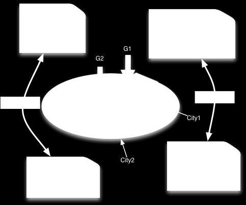
7 A Model to Compute the Links Coverage Geonames CityGML Urbamet Annotation Domain Ontologies Link document- object content/uploads/2009/03/vancouver1980.png Semantic alignment of documents with 3D city models, C. Tardy et al. 7
8 IndexaFon and AnnotaFon Documents are indexed Annotation RDF \ile Coverage Space Time 3d object annotation CityGML representation and Geonames identi\ication 8


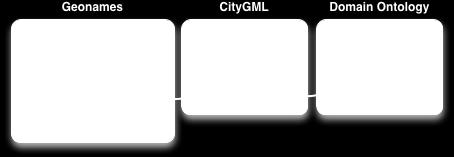
9 Ontology Alignment Indexation vocabularies CityGML Geonames Urbamet Domain Ontologies 9
10 IdenFficaFon Geonames CityGML Urbamet Domain Ontologies Link document- object content/uploads/2009/03/vancouver1980.png 10
11 IdenFfying city objects From CityGML to Geonames Position Function Rules to solve ambiguities 11

12 IdenFficaFon of City Objects 12
13 A Model to Compute the Links Coverage Geonames CityGML Urbamet Annotation Domain Ontologies Link document- object content/uploads/2009/03/vancouver1980.png Semantic alignment of documents with 3D city models, C. Tardy et al. 13
14 Find the connecfons Type of links Explicit (Boolean value) Direct or indirect connection Suggestion (Weight value) Through non- geographic entities Object is not contained in the 3DCM 14
15 Alignment Algorithm Input Document corpora (indexed) 3D city model (indexed) Output Matrix of links M(doc,obj) Focus on the spatial coverage 15
16 Algorithm One document, one object Cov(obj) Cov(doc) or vice versa CityGML/Geonames Search_link function 4 cases : 1. Direct link 2. Direct link by class 3. Link through non- geographic entities 4. Link by spatial proximity 16
17 Direct Link Cov(obj) G : Geneva airport G: Geneva airport Cov(doc) M(doc,obj)= true 17
")

=true")
18 Direct Link by Class Cov(obj) G : Geneva airport airport_ building M(doc,obj)=true Cov(doc) 18
 G: HUG")
19 Link through Non- geographic EnFFes Cov(obj) G: HUG surgery Idx(doc) M(doc,obj)=1/semantic_distance( surgery, HUG ) 19


 = f")


20 Link by SpaFal Proximity e not in cov(model) e and f are spatially close G: e G: e Cov(doc) Cov(model) = f (geoname) M(doc,obj)= 1/euclidean_distance(e,f) 20
21 ParFcular SituaFons The object is a group Storeys 21
 = Switzerland (geoname) Idx(doc) = Swiss, airline,")
22 Example : Geneva Airport aviation.com/ Cov(doc) = Switzerland (geoname) Idx(doc) = Swiss, airline, tablets, crew 22
")

23 Example : Geneva Airport Cov(obj) = BuildingFunctionType : Airport_Building (citygml) Cov(model) = Geneva Canton (geoname) e (geoname ) = label : Aéroport Genève- Cointrin, feature code : S.AIRP (Airport) 23
24 Example : Geneva Airport Switzerland contains Geneva Canton Idx(doc) contains airline Link between doc and all airports objects in the model M(doc,obj)=true - > explicit_link 24

 = Uni")

25 Example : University of Geneva Cov(doc) = Uni Dufour (geoname), Storey : name = 1 (CityGML) 25


26 Example : University of Geneva Obj is a group of 4 storeys : v o4 Storey : name = 3 v o3 Storey : name = 2 v o2 Storey : name = 1 v o1 Storey : name = 0 Cov(obj) = Uni Dufour (geoname) 26
27 Example : University of Geneva Cov(doc) and Cov(obj) contains Uni Dufour Cov(doc) - > Storey Search link with obj sub- objects Cov(o2)= Uni Dufour, Storey : name = 1 M(doc,o2)=true 27
28 Conclusion Semantic indexing Identify links through numerous connections Future Work : Evaluation via a use case Deal with fuzzy area Develop the different visualisation technics Develop the query system 28
29 References 1. W. Wiza, K. Walczak, W. Cellary, Proc. of the 9th Int. Conf. on 3D Web Technology. Periscope - A System for Adaptive 3D Visualization of Search Results (2004) 2. J. Cugini, S. Laskowski, M. Sebrechts, Proc. of IST/SPIE's 12th Annual Int. Symposium: Electronic Imaging. Design of 3D visualization of search results: Evolution and evaluation (2000) 3. C.B. Jones, A.I. Abdelmoty, D. Finch, G. Fu, S. Vaid, Proc. of the 3rd Int. Conf. on Geographic Information Science. The SPIRIT Spatial Search Engine: Architecture, Ontologies and Spatial Indexing (2004) 4. S. Ahern, M. Naaman, R. Nair, J.H.I. Yang, Proc. of the 7th JCDL. World explorer: visualizing aggregate data from unstructured text in geo- referenced collections (2007) 29
Spatial Information Retrieval
 Spatial Information Retrieval Wenwen LI 1, 2, Phil Yang 1, Bin Zhou 1, 3 [1] Joint Center for Intelligent Spatial Computing, and Earth System & GeoInformation Sciences College of Science, George Mason
A Simple Tags Categorization Framework Using Spatial Coverage to Discover Geospatial Semantics. TARDY, Camille, MOCCOZET, Laurent, FALQUET, Gilles
 Proceedings Chapter A Simple Tags Categorization Framework Using Spatial Coverage to Discover Geospatial Semantics TARDY, Camille, MOCCOZET, Laurent, FALQUET, Gilles Abstract There exist many popular crowdsourcing
Improving Geographical Data Finder Using Tokenize Approach from GIS Map API
 Improving Geographical Data Finder Using Tokenize Approach from GIS Map API Antveer Kaur Department of computer science Banasthali University, Jaipur, Rajasthan, India bntsnghbrr940@gmail.com Shweta Kumari
UBGI and Address Standards
 Workshop on address standards UBGI and Address Standards 2008. 5.25 Copenhagen, Denmark Sang-Ki Hong Convenor, WG 10 1 Evolution of Geographic Information Visualization Feature (Contents) Context Accessibility
UC Berkeley International Conference on GIScience Short Paper Proceedings
 UC Berkeley International Conference on GIScience Title Deriving Locational Reference through Implicit Information Retrieval Permalink https://escholarship.org/uc/item/0tn5s4v9 Journal International Conference
From Research Objects to Research Networks: Combining Spatial and Semantic Search
 From Research Objects to Research Networks: Combining Spatial and Semantic Search Sara Lafia 1 and Lisa Staehli 2 1 Department of Geography, UCSB, Santa Barbara, CA, USA 2 Institute of Cartography and
Extracting Touristic Information from Online Image Collections
 2012 Eighth International Conference on Signal Image Technology and Internet Based Systems Extracting Touristic Information from Online Image Collections Edoardo Ardizzone *, Francesco Di Miceli **, Marco
These modules are covered with a brief information and practical in ArcGIS Software and open source software also like QGIS, ILWIS.
 Online GIS Training and training modules covered are: 1. ArcGIS, Analysis, Fundamentals and Implementation 2. ArcGIS Web Data Sharing 3. ArcGIS for Desktop 4. ArcGIS for Server These modules are covered
ADAPTABLE DASHBOARD FOR VISUALIZATION OF ORIGIN-DESTINATION DATA PATTERNS
 ADAPTABLE DASHBOARD FOR VISUALIZATION OF ORIGIN-DESTINATION DATA PATTERNS Ieva Dobrāja, PhD Candidate Prof. Dr. Menno-Jan Kraak Dr. Yuri Engelhardt NCG Symposium 2017 ADAPTABLE DASHBOARD FOR VISUALIZATION
ADAPTABLE DASHBOARD FOR VISUALIZATION OF ORIGIN-DESTINATION DATA PATTERNS
 ADAPTABLE DASHBOARD FOR VISUALIZATION OF ORIGIN-DESTINATION DATA PATTERNS Ieva Dobrāja, PhD Candidate Prof. Dr. Menno-Jan Kraak Dr. Yuri Engelhardt NCG Symposium 2017 ADAPTABLE DASHBOARD FOR VISUALIZATION
GEOGRAPHICAL INFORMATION SYSTEMS. GIS Foundation Capacity Building Course. Introduction
 GEOGRAPHICAL INFORMATION SYSTEMS. GIS Foundation Capacity Building Course. Introduction In recent times digital mapping has become part and parcel of our daily lives with experience from Google Maps on
Geographic Analysis of Linguistically Encoded Movement Patterns A Contextualized Perspective
 Geographic Analysis of Linguistically Encoded Movement Patterns A Contextualized Perspective Alexander Klippel 1, Alan MacEachren 1, Prasenjit Mitra 2, Ian Turton 1, Xiao Zhang 2, Anuj Jaiswal 2, Kean
Cláudio Carneiro dell Ecole Polytechnique Federale de Lausanne
 URBAN UTILITY _ milano 22 03 2013 LA COSTRUZIONE DEL DATO COME PRESUPPOSTO DELLA DECISIONE PRIMA SESSIONE THE USE 3D GIS AND LIDAR DATA FOR URBAN PLANNING AND DECISION MAKING Cláudio Carneiro dell Ecole
MEU A cartographic-based web-platform for urban energy management and planning
 MEU A cartographic-based web-platform for urban energy management and planning Massimiliano Capezzali 1, Gaëtan Cherix 2, 1 Energy Center, Ecole Polytechnique Fédérale de Lausanne (EPFL), 1015 Lausanne
GIS-based Smart Campus System using 3D Modeling
 GIS-based Smart Campus System using 3D Modeling Smita Sengupta GISE Advance Research Lab. IIT Bombay, Powai Mumbai 400 076, India smitas@cse.iitb.ac.in Concept of Smart Campus System Overview of IITB Campus
Overview of CityGML. Dave Capstick, Ordnance Survey Research Department
 Overview of CityGML Dave Capstick, Ordnance Survey Research Department Introduction Why is citygml necessary CityGML development who is responsible? Ordnance Surveys interest 3D modelling basic concepts
The Relevance of Spatial Relation Terms and Geographical Feature Types
 The Relevance of Spatial Relation Terms and Geographical Feature Types Reporter Chunju Zhang Date: 2012-05-29 1 2 Introduction Classification of Spatial Relation Terms 3 4 5 Calculation of Relevance Conclusion
GIS CONCEPTS ARCGIS METHODS AND. 2 nd Edition, July David M. Theobald, Ph.D. Natural Resource Ecology Laboratory Colorado State University
 GIS CONCEPTS AND ARCGIS METHODS 2 nd Edition, July 2005 David M. Theobald, Ph.D. Natural Resource Ecology Laboratory Colorado State University Copyright Copyright 2005 by David M. Theobald. All rights
Finding geodata that otherwise would have been forgotten GeoXchange a portal for free geodata
 Finding geodata that otherwise would have been forgotten GeoXchange a portal for free geodata Sven Tschirner and Alexander Zipf University of Applied Sciences FH Mainz Department of Geoinformatics and
Smart Cities: Visualization
 Smart Cities: Visualization ISO/IEC JTC 1/SC24 Meetings 20-25 January 2019 Seoul, Korea Peter Ryan 1 and Myeong Won Lee 2 1 Defence Science & Technology Group, Australia 2 University of Suwon, Korea Presentation
Multiscale Spatio-Temporal Data Aggregation and Mapping for Urban Data Exploration
 Multiscale Spatio-Temporal Data Aggregation and Mapping for Urban Data Exploration Etienne Co me1 and Anaı s Remy2 1- Universite Paris-Est, COSYS, GRETTIA, IFSTTAR, F-77447 Marne-la-Valle e, France 2-
Comparison between ontology distances (preliminary results)
") Comparison between ontology distances (preliminary results) Jérôme David, Jérôme Euzenat ISWC 2008 1 / 17 Context A distributed and heterogenous environment: the semantic Web Several ontologies on the
Comparison between ontology distances (preliminary results) Jérôme David, Jérôme Euzenat ISWC 2008 1 / 17 Context A distributed and heterogenous environment: the semantic Web Several ontologies on the
Universities of Leeds, Sheffield and York
 promoting access to White Rose research papers Universities of Leeds, Sheffield and York http://eprints.whiterose.ac.uk/ This is an author produced version of a paper published in International Journal
TOWARDS AN INTEGRATED VISUALIZATION OF SEMANTICALLY ENRICHED 3D CITY MODELS: AN ONTOLOGY OF 3D VISUALIZATION TECHNIQUES
 TOWARDS AN INTEGRATED VISUALIZATION OF SEMANTICALLY ENRICHED 3D CITY MODELS: AN ONTOLOGY OF 3D VISUALIZATION TECHNIQUES Claudine Métral, Nizar Ghoula and Gilles Falquet Centre universitaire d informatique,
Spatio-Textual Indexing for Geographical Search on the Web
 Spatio-Textual Indexing for Geographical Search on the Web Subodh Vaid 1, Christopher B. Jones 1, Hideo Joho 2 and Mark Sanderson 2 1 School of Computer Science, Cardiff University, UK email: {c.b.jones,
3D Urban Information Models in making a smart city the i-scope project case study
 UDC: 007:528.9]:004; 007:912]:004; 004.92 DOI: 10.14438/gn.2014.17 Typology: 1.04 Professional Article 3D Urban Information Models in making a smart city the i-scope project case study Dragutin PROTIĆ
UNIT 4: USING ArcGIS. Instructor: Emmanuel K. Appiah-Adjei (PhD) Department of Geological Engineering KNUST, Kumasi
 Department of Geological Engineering KNUST, Kumasi") UNIT 4: USING ArcGIS Instructor: Emmanuel K. Appiah-Adjei (PhD) Department of Geological Engineering KNUST, Kumasi Getting to Know ArcGIS ArcGIS is an integrated collection of GIS software products ArcGIS
UNIT 4: USING ArcGIS Instructor: Emmanuel K. Appiah-Adjei (PhD) Department of Geological Engineering KNUST, Kumasi Getting to Know ArcGIS ArcGIS is an integrated collection of GIS software products ArcGIS
ToxiCat: Hybrid Named Entity Recognition services to support curation of the Comparative Toxicogenomic Database
 ToxiCat: Hybrid Named Entity Recognition services to support curation of the Comparative Toxicogenomic Database Dina Vishnyakova 1,2, 4, *, Julien Gobeill 1,3,4, Emilie Pasche 1,2,3,4 and Patrick Ruch
Canadian Board of Examiners for Professional Surveyors Core Syllabus Item C 5: GEOSPATIAL INFORMATION SYSTEMS
 Study Guide: Canadian Board of Examiners for Professional Surveyors Core Syllabus Item C 5: GEOSPATIAL INFORMATION SYSTEMS This guide presents some study questions with specific referral to the essential
GEOGRAPHIC INFORMATION SYSTEMS Session 8
 GEOGRAPHIC INFORMATION SYSTEMS Session 8 Introduction Geography underpins all activities associated with a census Census geography is essential to plan and manage fieldwork as well as to report results
Basics of GIS reviewed
 Basics of GIS reviewed Martin Breunig Karlsruhe Institute of Technology martin.breunig@kit.edu GEODETIC INSTITUTE, DEPARTMENT OF CIVIL ENGINEERING, GEO AND ENVIRONMENTAL SCIENCES, CHAIR IN GEOINFORMATICS
Understanding Interlinked Data
 Understanding Interlinked Data Visualising, Exploring, and Analysing Ontologies Olaf Noppens and Thorsten Liebig (Ulm University, Germany olaf.noppens@uni-ulm.de, thorsten.liebig@uni-ulm.de) Abstract Companies
GIS CONCEPTS ARCGIS METHODS AND. 3 rd Edition, July David M. Theobald, Ph.D. Warner College of Natural Resources Colorado State University
 GIS CONCEPTS AND ARCGIS METHODS 3 rd Edition, July 2007 David M. Theobald, Ph.D. Warner College of Natural Resources Colorado State University Copyright Copyright 2007 by David M. Theobald. All rights
Desktop GIS for Geotechnical Engineering
 Desktop GIS for Geotechnical Engineering Satya Priya Deputy General Manager (Software) RMSI, A-7, Sector 16 NOIDA 201 301, UP, INDIA Tel: +91-120-2511102 Fax: +91-120-2510963 Email: Satya.Priya@rmsi.com
INTRODUCTION. In March 1998, the tender for project CT.98.EP.04 was awarded to the Department of Medicines Management, Keele University, UK.
 INTRODUCTION In many areas of Europe patterns of drug use are changing. The mechanisms of diffusion are diverse: introduction of new practices by new users, tourism and migration, cross-border contact,
A Semantic Enhanced Model for Effective Spatial Information Retrieval
 A Semantic Enhanced Model for Effective Spatial Information Retrieval Adeyinka Akanbi, Olusanya Agunbiade, Olumuyiwa Dehinbo, Sadiq Kuti To cite this version: Adeyinka Akanbi, Olusanya Agunbiade, Olumuyiwa
Dynamic Ontology Service for Historical Persons and Places Based on Crowdsourcing
 Dynamic Ontology Service for Historical Persons and Places Based on Crowdsourcing 22.1.2016, COST RRL WG2 Workshop Jouni Tuominen Semantic Computing Research Group (SeCo), http://seco.cs.aalto.fi, Aalto
Hyderabad , A.P, India. Pretoria Campus, South Africa.
 A Semantic Enhanced Model for effective Spatial Information Retrieval Adeyinka K. Akanbi 1, Olusanya Y. Agunbiade 2, Sadiq Kuti 3, Olumuyiwa J. Dehinbo 4 1 Institute of Science & Technology, Jawaharlal
4CitySemantics. GIS-Semantic Tool for Urban Intervention Areas
 4CitySemantics GIS-Semantic Tool for Urban Intervention Areas Nuno MONTENEGRO 1 ; Jorge GOMES 2 ; Paulo URBANO 2 José P. DUARTE 1 1 Faculdade de Arquitectura da Universidade Técnica de Lisboa, Rua Sá Nogueira,
Joint MISTRAL/CESI lunch workshop 15 th November 2017
 MISTRAL@Newcastle Joint MISTRAL/CESI lunch workshop 15 th November 2017 ITRC at Newcastle ITRC at Newcastle MISTRAL at Newcastle New approach to infrastructure data management to open-up analytics, modelling
On the convergence of 3D-GIS, CAD and 3D Simulation
 On the convergence of 3D-GIS, CAD and 3D Simulation V. Coors, Stuttgart University of Applied Science, Volker.Coors@hft-stuttgart.de Urban information space Due to improved tools for the design and acquisition
Framework for on an open 3D urban analysis platform based on OGC Web Services
 Platzhalter für Bild, Bild auf Titelfolie hinter das Logo einsetzen Framework for on an open 3D urban analysis platform based on OGC Web Services Marc-O. Löwner & Thomas Adolphi (née Becker) Technische
3-D visualization of Urban Environmental Quality indicators
 3-D visualization of Urban Environmental Quality indicators Using the CityGML standard Cláudio CARNEIRO 1 ; François GOLAY 1 ; Stéphane JOOST 1 ; Gilles DESTHIEUX 2 ; Adrien Vieira de MELLO 3 ; Eugenio
An Information System Design Theory for Spatial Decision Support System Development
 Association for Information Systems AIS Electronic Library (AISeL) AMCIS 2004 Proceedings Americas Conference on Information Systems (AMCIS) December 2004 An Information System Design Theory for Spatial
Indexing Structures for Geographic Web Retrieval
 Indexing Structures for Geographic Web Retrieval Leonardo Andrade 1 and Mário J. Silva 1 University of Lisboa, Faculty of Sciences Abstract. Context-aware search in mobile web environments demands new
Spatializing Research Hypotheses a long- term research vision for
 Spatializing Research Hypotheses a long- term research vision for spatial@ucsb Werner Kuhn Center for Spatial Studies a vision for spatial Spatial computing shall reach the same level of general utility
Smart Cities: Data Representation Model
 Smart Cities: Data Representation Model ISO/IEC JTC 1/SC24 Meetings 19-24 January 2019 Seoul, Korea Peter Ryan 1 and Myeong Won Lee 2 1 Defence Science & Technology Group, Australia 2 University of Suwon,
HANDLING UNCERTAINTY IN INFORMATION EXTRACTION
 HANDLING UNCERTAINTY IN INFORMATION EXTRACTION Maurice van Keulen and Mena Badieh Habib URSW 23 Oct 2011 INFORMATION EXTRACTION Unstructured Text Information extraction Web of Data Inherently imperfect
GIS Software. Evolution of GIS Software
 GIS Software The geoprocessing engines of GIS Major functions Collect, store, mange, query, analyze and present Key terms Program collections of instructions to manipulate data Package integrated collection
INTELLIGENT MAPS FOR VISION ENHANCED MOBILE INTERFACES IN URBAN SCENARIOS
 INTELLIGENT MAPS FOR VISION ENHANCED MOBILE INTERFACES IN URBAN SCENARIOS Linde Vande Velde 1*, Patrick Luley 2, Alexander Almer 2, Christin Seifert 2, and Lucas Paletta 2** 1. Tele Atlas, Gent, Belgium
John Laznik 273 Delaplane Ave Newark, DE (302)
") Office Address: John Laznik 273 Delaplane Ave Newark, DE 19711 (302) 831-0479 Center for Applied Demography and Survey Research College of Human Services, Education and Public Policy University of Delaware
Office Address: John Laznik 273 Delaplane Ave Newark, DE 19711 (302) 831-0479 Center for Applied Demography and Survey Research College of Human Services, Education and Public Policy University of Delaware
Making interoperability persistent: A 3D geo database based on CityGML
 Making interoperability persistent: A 3D geo database based on CityGML Alexandra Stadler, Claus Nagel, Gerhard König, Thomas H. Kolbe Technische Universität Berlin Chair of Geoinformation Science Motivation
GENERALIZATION IN THE NEW GENERATION OF GIS. Dan Lee ESRI, Inc. 380 New York Street Redlands, CA USA Fax:
 GENERALIZATION IN THE NEW GENERATION OF GIS Dan Lee ESRI, Inc. 380 New York Street Redlands, CA 92373 USA dlee@esri.com Fax: 909-793-5953 Abstract In the research and development of automated map generalization,
A critical evaluation of ontology languages for geographic information retrieval on the Internet
 Journal of Visual Languages and Computing 16 (2005) 331 358 Journal of Visual Languages & Computing www.elsevier.com/locate/jvlc A critical evaluation of ontology languages for geographic information retrieval
Automatically generating keywords for georeferenced images
 Automatically generating keywords for georeferenced images Ross S. Purves 1, Alistair Edwardes 1, Xin Fan 2, Mark Hall 3 and Martin Tomko 1 1. Introduction 1 Department of Geography, University of Zurich,
Acknowledgments xiii Preface xv. GIS Tutorial 1 Introducing GIS and health applications 1. What is GIS? 2
 Acknowledgments xiii Preface xv GIS Tutorial 1 Introducing GIS and health applications 1 What is GIS? 2 Spatial data 2 Digital map infrastructure 4 Unique capabilities of GIS 5 Installing ArcView and the
The Global Statistical Geospatial Framework and the Global Fundamental Geospatial Themes
 The Global Statistical Geospatial Framework and the Global Fundamental Geospatial Themes Sub-regional workshop on integration of administrative data, big data and geospatial information for the compilation
Modeling and Managing the Semantics of Geospatial Data and Services
 Modeling and Managing the Semantics of Geospatial Data and Services Werner Kuhn, Martin Raubal, Michael Lutz Institute for Geoinformatics University of Münster (Germany) {kuhn, raubal, m.lutz}@uni-muenster.de
UNDER REVIEW. Abstract
 UNDER REVIEW Getting To Know ArcGIS Desktop By: Ormsby, Napoleon, Burke, Groessl, and Bowden, (2010). Format: (Softcover, 592 pp. ISBN: 9781589482609) Publisher: Redlands, California: ESRI Press Abstract
The Significance and Role of GIS and CSDI in Smart City Development
 The Significance and Role of GIS and CSDI in Smart City Development Dr. Kenneth Tang Immediate Past President, HKGISA Chairman, Spatial Data Infrastructure (SDI) Committee, Smart City Consortium 20 June
Tutorial: Urban Trajectory Visualization. Case Studies. Ye Zhao
 Case Studies Ye Zhao Use Cases We show examples of the web-based visual analytics system TrajAnalytics The case study information and videos are available at http://vis.cs.kent.edu/trajanalytics/ Porto
Where do I live? Geography teaching resource. Paula Owens. Primary. Locating own home address
 Where do I live? Locating own home address Paula Owens Geography teaching resource Primary Digimap for Schools Geography Resources Where do I live Level Context Location Primary Locating own home address
Web 3D Service & CityGML Update
 Technische Universität Berlin Web 3D Service & CityGML Update Thomas H. Kolbe Institute for Geodesy and Geoinformation Science Berlin University of Technology kolbe@igg.tu-berlin.de 2nd of November, 2007
Environmental & Socio-economic impacts of mass rapid transit using GIS
 Environmental & Socio-economic impacts of mass rapid transit using GIS BITS Pilani Pilani Campus Dr. Rajiv Gupta, Senior Professor, Department of Civil Engineering, Birla Institute of Technology and Science
USING GIS IN WATER SUPPLY AND SEWER MODELLING AND MANAGEMENT
 USING GIS IN WATER SUPPLY AND SEWER MODELLING AND MANAGEMENT HENRIETTE TAMAŠAUSKAS*, L.C. LARSEN, O. MARK DHI Water and Environment, Agern Allé 5 2970 Hørsholm, Denmark *Corresponding author, e-mail: htt@dhigroup.com
ArcGIS Pro: Essential Workflows STUDENT EDITION
 ArcGIS Pro: Essential Workflows STUDENT EDITION Copyright 2018 Esri All rights reserved. Course version 6.0. Version release date August 2018. Printed in the United States of America. The information contained
A General Framework for Conflation
 A General Framework for Conflation Benjamin Adams, Linna Li, Martin Raubal, Michael F. Goodchild University of California, Santa Barbara, CA, USA Email: badams@cs.ucsb.edu, linna@geog.ucsb.edu, raubal@geog.ucsb.edu,
Valdosta State University Strategic Research & Analysis
 Christopher Neasbitt, Programmer Analyst Associate (cjneasbi@valdosta.edu) Kristina M. Cragg, Ph.D., Assistant to the President for Strategic Research & Analysis (kmcragg@valdosta.edu) Amir Atabekov, Student
7th FIG Regional Conference Spatial Data Serving People: Land Governance and the Environment - Building the Capacity
 7th FIG Regional Conference Spatial Data Serving People: Land Governance and the Environment - Building the Capacity Hanoi, Vietnam, 19-22 October 2009 ------------------ TS 3A - SDI in Support of Urban
Part 1: Fundamentals
 Provläsningsexemplar / Preview INTERNATIONAL STANDARD ISO 19101-1 First edition 2014-11-15 Geographic information Reference model Part 1: Fundamentals Information géographique Modèle de référence Partie
Specialist Meeting on Spatial Concepts in GIS and Design Santa Barbara, California. Geo-Spatial Design
 Specialist Meeting on Spatial Concepts in GIS and Design Santa Barbara, California Geo-Spatial Design Creativity is the synapse between two normally disassociated matrices of thought. Arthur Koestler William
How to make R, PostGIS and QGis cooperate for statistical modelling duties: a case study on hedonic regressions
 How to make R, PostGIS and QGis cooperate for statistical modelling duties: a case study on hedonic regressions Olivier Bonin To cite this version: Olivier Bonin. How to make R, PostGIS and QGis cooperate
Key Words: geospatial ontologies, formal concept analysis, semantic integration, multi-scale, multi-context.
 Marinos Kavouras & Margarita Kokla Department of Rural and Surveying Engineering National Technical University of Athens 9, H. Polytechniou Str., 157 80 Zografos Campus, Athens - Greece Tel: 30+1+772-2731/2637,
Exploring Visualization of Geospatial Ontologies Using Cesium
 Exploring Visualization of Geospatial Ontologies Using Cesium Abhishek V. Potnis, Surya S. Durbha Centre of Studies in Resources Engineering, Indian Institue of Technology Bombay, India abhishekvpotnis@iitb.ac.in,
Spatializing time in a history text corpus
 Zurich Open Repository and Archive University of Zurich Main Library Strickhofstrasse 39 CH-8057 Zurich www.zora.uzh.ch Year: 2014 Spatializing time in a history text corpus Bruggmann, André; Fabrikant,
Geospatial Semantics for Topographic Data
 Geospatial Semantics for Topographic Data E. Lynn Usery U.S. Geological Survey Abstract. Whereas The National Map of the U.S. Geological Survey is based on data models and processes of geographic information
DP Project Development Pvt. Ltd.
 Dear Sir/Madam, Greetings!!! Thanks for contacting DP Project Development for your training requirement. DP Project Development is leading professional training provider in GIS technologies and GIS application
Exploring Spatial Relationships for Knowledge Discovery in Spatial Data
 2009 International Conference on Computer Engineering and Applications IPCSIT vol.2 (2011) (2011) IACSIT Press, Singapore Exploring Spatial Relationships for Knowledge Discovery in Spatial Norazwin Buang
NOKIS an ISO Based Metadata System
 NOKIS an ISO 19115 Based Metadata System Carsten Heidmann BAW Hamburg (Tyskland) Overview Project NOKIS/NOKIS++ NOKIS Editor Metadata Infrastructure Germany NOKIS Tools: Survey Planning Tool Conclusions
Alexander Klippel and Chris Weaver. GeoVISTA Center, Department of Geography The Pennsylvania State University, PA, USA
 Analyzing Behavioral Similarity Measures in Linguistic and Non-linguistic Conceptualization of Spatial Information and the Question of Individual Differences Alexander Klippel and Chris Weaver GeoVISTA
BIM-GIS Oriented Inteligente Knowledge Discovery
 BIM-GIS Oriented Inteligente Knowledge Discovery H. Kiavarz 1, M. Jadidi 1, A. Rajabifard 2, G. Sohn 1 1 Geomatics Engineering, Department of Earth & Space Science & Engineering, York University, Toronto,
Citation for published version (APA): Andogah, G. (2010). Geographically constrained information retrieval Groningen: s.n.
: Andogah, G. (2010). Geographically constrained information retrieval Groningen: s.n.") University of Groningen Geographically constrained information retrieval Andogah, Geoffrey IMPORTANT NOTE: You are advised to consult the publisher's version (publisher's PDF) if you wish to cite from
University of Groningen Geographically constrained information retrieval Andogah, Geoffrey IMPORTANT NOTE: You are advised to consult the publisher's version (publisher's PDF) if you wish to cite from
Pushing the Standards Edge: Collaborative Testbeds to Accelerate Standards Development and Implementation
 Pushing the Standards Edge: Collaborative Testbeds to Accelerate Standards Development and Implementation Mark E. Reichardt President mreichardt@opengeospatial.org 31 October 2006 2006 Open Geospatial
Chapter 10: BIM for Facilitation of Land Administration Systems in Australia
 Chapter 10: BIM for Facilitation of Land Administration Systems in Australia Sam Amirebrahimi Introduction With the introduction of the concept of 3D Cadastre and extensive efforts in this area, currently
Geospatial Ontology Trade Study
 Ontology for the Intelligence Community (OIC-2007) November 28-29, 2007 Columbia, Maryland Geospatial Ontology Trade Study James Ressler 1, Mike Dean 2 1 a james.ressler@ngc.com Northrop Grumman Corporation
Assessing pervasive user-generated content to describe tourist dynamics
 Assessing pervasive user-generated content to describe tourist dynamics Fabien Girardin, Josep Blat Universitat Pompeu Fabra, Barcelona, Spain {Fabien.Girardin, Josep.Blat}@upf.edu Abstract. In recent
Visualizing Uncertainty: How to Use the Fuzzy Data of 550 Medieval Texts?
 Visualizing Uncertainty: How to Use the Fuzzy Data of 550 Medieval Texts? Stefan Jänicke, Institut für Informatik, Universität Leipzig David Joseph Wrisley, Department of English, American University of
Lecture 1: Geospatial Data Models
 Lecture 1: GEOG413/613 Dr. Anthony Jjumba Introduction Course Outline Journal Article Review Projects (and short presentations) Final Exam (April 3) Participation in class discussions Geog413/Geog613 A
The Role of Ontology in Improving Gazetteer Interaction
 International Journal of Geographical Information Science Vol. 00, No. 00, Month 200x, 1 24 The Role of Ontology in Improving Gazetteer Interaction Krzysztof Janowicz & Carsten Keßler Institute for Geoinformatics,
Developing Geo-temporal Context from Implicit Sources with Geovisual Analytics
 Developing Geo-temporal Context from Implicit Sources with Geovisual Analytics Brian Tomaszewski 1 1 The Pennsylvania State University, Department of Geography, 302 Walker Building University Park, PA,
GIS-based Smart Campus System using 3D Modeling
 GIS-based Smart Campus System using 3D Modeling Hardik Panchal & Rizwan Khan, Smita Sengupta, GISE Advance Lab, Indian Institute of Technology, Bombay, India N.L. Sarda, Dept. Of Computer Science, Indian
A CARTOGRAPHIC DATA MODEL FOR BETTER GEOGRAPHICAL VISUALIZATION BASED ON KNOWLEDGE
 A CARTOGRAPHIC DATA MODEL FOR BETTER GEOGRAPHICAL VISUALIZATION BASED ON KNOWLEDGE Yang MEI a, *, Lin LI a a School Of Resource And Environmental Science, Wuhan University,129 Luoyu Road, Wuhan 430079,
A Distributed GIS Architecture for Research in Baalbek Based on CISAR
 234 Frank Henze A Distributed GIS Architecture for Research in Baalbek Based on CISAR Abstract: Research underway in Baalbek extends from the immediate vicinity of the excavation areas to the monumental
12th AGILE International Conference on Geographic Information Science 2009 page 1 of 9 Leibniz Universität Hannover, Germany
 12th AGILE International Conference on Geographic Information Science 2009 page 1 of 9 A Framework for the Generalization of 3D City Models Richard Guercke and Claus Brenner Institute of Cartography and
CSCE 561 Information Retrieval System Models
 CSCE 561 Information Retrieval System Models Satya Katragadda 26 August 2015 Agenda Introduction to Information Retrieval Inverted Index IR System Models Boolean Retrieval Model 2 Introduction Information
THE WASHINGTON COASTAL ATLAS
 THE ICAN COASTAL ATLAS MEDIATOR PROTOTYPE AND CONNECTING THE WASHINGTON COASTAL ATLAS Liz O Dea 1, Yassine Lassoued 2, Tanya Haddad 3, Declan Dunne 2 1 GIS Services Unit, WA State Dept. of Ecology 2 Coastal
ArcGIS Platform For NSOs
 ArcGIS Platform For NSOs Applying GIS and Spatial Thinking to Official Statistics Esri UC 2014 Demo Theater Applying GIS at the NSO Generic Statistical Business Process Model (GSBPM) 1 Specify Needs 2
GOVERNMENT GIS BUILDING BASED ON THE THEORY OF INFORMATION ARCHITECTURE
 GOVERNMENT GIS BUILDING BASED ON THE THEORY OF INFORMATION ARCHITECTURE Abstract SHI Lihong 1 LI Haiyong 1,2 LIU Jiping 1 LI Bin 1 1 Chinese Academy Surveying and Mapping, Beijing, China, 100039 2 Liaoning
Semantic Evolution of Geospatial Web Services: Use Cases and Experiments in the Geospatial Semantic Web
 Semantic Evolution of Geospatial Web Services: Use Cases and Experiments in the Geospatial Semantic Web Joshua Lieberman, Todd Pehle, Mike Dean Traverse Technologies, Inc., Northrop Grumman Information
Lecture 3 GIS outputs. Dr. Zhang Spring, 2017
 Lecture 3 GIS outputs Dr. Zhang Spring, 2017 Model of the course Using and making maps Navigating GIS maps Map design Working with spatial data Geoprocessing Spatial data infrastructure Digitizing File